Additional Policies & Objectives for Local Area Plans Ashbourne LAP. Ashbourne
|
|
|
- Marshall Dennis
- 6 years ago
- Views:
Transcription
1 Ashbourne Strategic Policies SP 1 To operate an Order of Priority for the release of residential lands in compliance with the requirements of CS OBJ 6 of the County Development Plan as follows: i) The lands identified with an A2 New Residential land use zoning objective corresponds with the requirements of Table 2.4 Housing Allocation & Zoned Land Requirements in Volume I of this County Development Plan and are available for residential development within the life of this Development Plan. SP 2 ii) The lands identified with an A2 New Residential land use zoning objective but qualified as Residential Phase II (Post 2019) are not available for residential development within the life of this Development Plan. To operate an Order of Priority for release of lands identified for E2 General Enterprise & Employment in compliance with the requirements of ED OBJ 2 as follows: i) The lands identified with an E2 General Enterprise & Employment land use zoning objective are available for development within the life of this Development Plan. ii) The lands identified with an E2 General Enterprise & Employment land use zoning objective but qualified as Phase II will only be available for development when all of the Phase I lands have been developed or being developed (i.e. permission granted and development substantially completed) and may be available within the life of this Development Plan. iii) Should a significant development be proposed which could not be accommodated only within the lands identified as Phase I, lands within Phase II may be considered in this regard. The development of the lands identified as Phase II will be subject to the preparation and agreement of a Framework Plan with the Planning Authority prior to the submission of any planning application on said lands. Policies Flood Risk FR POL 1 FR POL 2 FR POL 3 To manage flood risk and development in Ashbourne in line with policies WS 29 WS 36 inclusive in Volume I of this County Development Plan. Where existing development in the development envelop is at potential risk of flooding (A1 Existing Residential, B1 Town Centre & G1 Community Infrastructure land use zoning objectives refer) as identified on the land use zoning objectives map, any significant extensions / change of use / reconstruction shall be subject to an appropriately detailed Flood Risk Assessment in line with the policies (WS POL 29-36) contained in Volume I of the County Development Plan. Any future planning applications lodged with respect to the sites identified on the land use zoning objectives map as having the benefit of an extant planning permission in the general Killegland area to the south west of
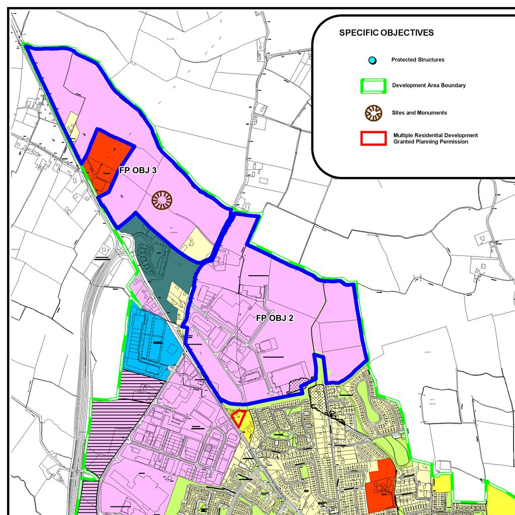
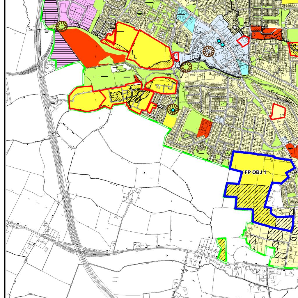
2 Objectives Flood Risk Ashbourne shall be accompanied by an appropriately detailed Flood Risk Assessment. The Flood Risk Assessment shall clearly assess flood risks, management measures and demonstrate compliance with the The Planning System and Flood Risk Management Guidelines for Planning Authorities (November 2009). The Flood Risk Assessment shall consider the Sequential Approach within the subject site and would typically involve allocating water compatible development within Flood Zones A and Zone B. Buildings should be sited at an appropriate finished floor level, which should be above the 1 in 100 year flood level, with an allowance for freeboard and climate change. FR OBJ To seek to implement the recommendations of the Fingal East Meath Flood Risk Assessment and Management Study (FEMFRAMS) as applicable to the River Broadmeadow with particular regard to ensuring that the existing culverts of the river in Ashbourne are maintained and kept clear of obstructions at all times and that a defence asset monitoring and maintenance programme is undertaken. Land Use FP OBJ 1 Framework Plan Area 1 This Framework Plan relates to lands at Milltown to the south of Ashbourne and extends to 19.9 hectares in area hectares is included within Phase I and a further 9.74 hectares is within Phase II. It is intended that the lands shall provide a primary school site, lands for recreational purposes and residential development. The Framework Plan for these lands shall include, inter alia: A mix of uses to include educational, residential, playing pitches & recreational lands shall be provided; Details of overall site and building layout; High quality residential development with a mixture of housing types; A comprehensive landscaping scheme; A primary school site of 0.77 hectares is to be delivered in conjunction with the development of the Phase 1 residential land; Provision of adequate public lighting and footpaths throughout the lands; High quality design, finish and layout, and; Infrastructural requirements including access for vehicle, pedestrians, cyclists and people with disabilities, car parking and vehicle turning.
3 FP OBJ 2 Framework Plan Area 2 This Framework Plan relates to lands at Ashbourne Business Park extending to 47.4 hectares in area. It is intended that these lands shall provide for light industrial and industrial office type employment in a high quality campus environment. The Framework Plan for these lands shall include, inter alia: A comprehensive landscaping scheme; Details of overall site and building layout; Provision of adequate public lighting and footpaths throughout the lands; High quality design, finish and layout; Infrastructural and services requirements including access for vehicles, pedestrians, cyclists and people with disabilities, car parking and vehicle turning; Access via the existing entrance off the L5018 or utilising existing access points onto the national road network. Access arrangements shall be determined as part of the Framework Plan; Provision of a civic amenity facility, and; Provision of a machinery/storage depot of approximately 0.5 hectares/1 acre (objective ECON DEV OBJ 10 of Ashbourne Local Area Plan refers). FP OBJ 3 Framework Plan Area 3 This Framework Plan relates to lands off the N2 and L5018 to the northwest of the Ashbourne Business Park. These lands extend to 30.46ha in area. Existing residences have been omitted from this zoning and zoned according to their current use. A Framework Plan has been prepared by the Planning Authority in relation to these lands. Any development within this area shall generally accord with the agreed Framework Plan. Section 4.3 of the Meath County Development Plan outlines that a specific local zoning objective may be applied to lands within a broad zoning category where the Council is seeking to achieve a special objective. The Framework Plan 2 lands are identified with an E2, General Enterprise & Employment (Category 1) land use zoning objective. However, these lands represent a unique opportunity as an extremely well serviced site within the fringe of South Meath and Metropolitan Dublin. The site is well placed along the route of the main Eirgrid east/west inter-connector between Woodland, Co. Meath and Deeside (UK) which offers great opportunities for enterprises that require guaranteed delivery of power. Furthermore, the site is bisected by both the Aurora Telcom National Network and An Bord Gáis pipeline providing excellent fibre based broadband and power connections. The local zoning objective set down for these lands is as follows: To provide for the development of data centre facilities and associated related industries set in open parkland with extensive landscaping, a high architectural standard of layout and building design. Employment types other than those strictly related to data storage shall show a clear process related requirement to locate in proximity to a data centre. A data centre is a facility used to house computer systems and associated components, such as telecommunications and storage systems. It generally includes redundant or backup power supplies, redundant data communications connections, environmental controls (e.g. air conditioning, fire suppression) and security devices. Any revisions to the Framework Plan shall require the prior written agreement of the Planning Authority.
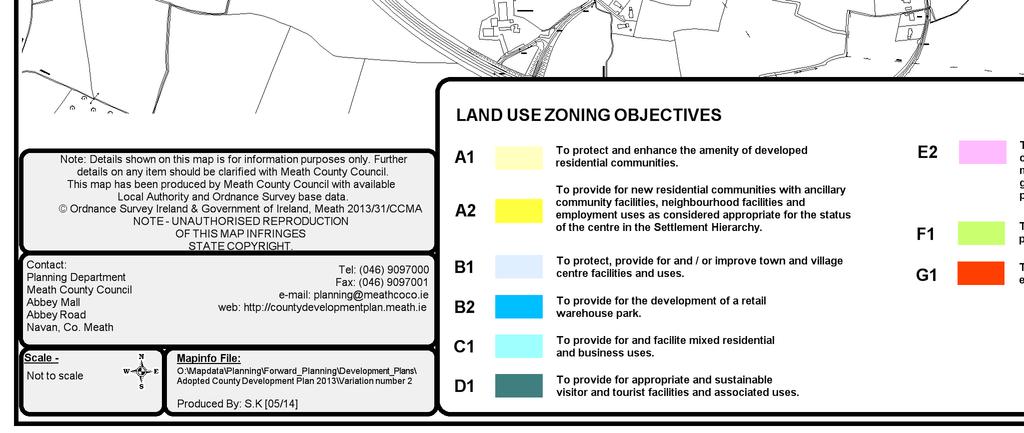
4 Ashbourne Local Area Plan Residential & Employment Land Evaluation Ashbourne Local Area Plan Residential & Employment Land Evaluation 1.0 Household Allocation The Core Strategy contained in Volume 1 of the Meath County Development Plan allocates 637 no. units (which include 50% headroom) to Ashbourne over the lifetime of the Plan. Table 1 is an extract from Table 2.4 of the Core Strategy as it relates to Ashbourne. Table 1: Housing Allocation and Zoned Land Requirements for Ashbourne Household Allocation Av. Net Density Applicable unit/ha Quantity of Residential Zoned Land Required Available Land Zoned for Residential Use (ha) Available Land Zoned for Mixed Use incl. Residential (ha) 1 Total Available Zoned Land (ha) Deficit/ Excess (ha) According to Table 2.5 of the County Development Plan, there were 1,356 no. units with planning permission in Ashbourne at the time of preparation of the Meath County Development Plan This is revised downwards slightly to 1,322 no. units in It is clear from Table 1 above that there was a significant excess of residential zoned land contained in the Local Area Plan for Ashbourne as adopted in 2009 in comparison to that now required to satisfy the household allocation provided for in the Core Strategy. The Ashbourne Local Area Plan is legally obliged to be consistent with the Meath County Development Plan, its Core Strategy and with the household projections and population growth contained therein. In order to do this, an evidence based approach was developed to evaluate the lands which benefitted from a residential land use zoning objective. 2.0 Residential Land Evaluation The amended land use zoning objectives map has identified the lands required to accommodate the household allocation of 637 no. units provided for under the Core Strategy. It should be noted that there is already headroom included in the household allocations of 50% and thus there is no justification for the release of any additional lands over and above those specified in Table 4 and illustrated on the land use zoning objectives map for Ashbourne. The requirement for any further release of residential zoned land in Ashbourne will be assessed following the making of the next County Development Plan in line with the population projections contained therein. The sites that were evaluated are detailed in Table 2. The location of these lands is illustrated on the maps in Appendix 2 to Volume 5 (Residential Land Evaluation Maps). In carrying out the residential land evaluation, a strong emphasis was placed on a sequential approach to development, in line with the guidance contained in Section of the County Development Plan. The use of the Justification Test for lands at risk of flooding was not considered necessary in light of the extent and nature of alternative residential zoned land at a lower risk of flooding. The evaluation of the development areas therefore excluded those areas within the identified flood risk mapping. The evaluation also excluded all sites with the benefit of an extant permission and sites approximating 0.5 hectares in area. 1 Note that the figure entered represents 30% of the total available mixed use land zoning, reflecting that residential uses would be a subsidiary use in these zoning categories that relate to town and village centre sites and edge of centre sites.
5 The following factors, which were considered to constitute the proper planning and sustainable development of the area and which take into account policy at county, regional and national level, have been used to determine the suitability of specific lands for residential development in Ashbourne: Proximity to the town centre: maximise the utility of existing and proposed future infrastructure including public transport options; Availability of public transport: To maximise public transport investment, it is important that land use planning underpins its efficiency by sustainable transport patterns; Availability of community and social infrastructure facilities with particular regard to the proximity to educational facilities; Consistency with sequential approach to urban expansion and contribution to a compact urban form. The development of infill sites makes a significant contribution in this regard. Leapfrogging beyond other available sites will not be considered favourably, and; Whether the site is serviced. Distance to the town centre, schools (primary and secondary) and bus stops was calculated on the basis of concentric circles. The town centre was taken to be at the Parochial Hall on Frederick Street. Sites scored 1 point if they were less than 500 metres distance from the point of interest; 2 points if the distance was 500 metres; 3 points if the distance was between 501 metres and 1 kilometre; 4 points if the distance was 1 kilometre and 5 points if the distance was in excess of 1 kilometre. Table 3 details the results of this evaluation. The sites that scored the highest in the evaluation (sites 1-5) have been prioritised for release during the lifetime of the Meath County Development Plan All other sites evaluated are indicated as being in Phase II (Post 2011). The phasing map attached gives effect to this assessment. Sites G and F located in south Ashbourne, in an unserviced area removed from the town centre, ranked the lowest. The timeline for release, if appropriate, of these lands will be considered post 2019 in accordance with the relevant Meath County Development Plan in place at that time. Having consulted with the Department of Education and Skills, the existing G1 Community Infrastructure zoned lands in Killegland has been expanded to potentially accommodate three no. schools. Furthermore, land zoned for residential development (Phase I) in south Ashbourne includes an additional area of 0.77 hectares for the provision of a school to be delivered in conjunction with the development of the residential lands. Table 2: Description of individually zoned available sites evaluated Site Location Hectares A Land to the north of Ashewood Glenn east of Hunters Lane 2.17 B Land to the north of Archerstown Wood residential development 3.14 C Land south of the Community Centre and Ashbourne Community school 3.3 D Land fronting onto R135 south of the Briars residential development and 1.85 to the rear of existing residences E Land surrounded by existing residences adjacent to R135 just north of 4.05 the Ninemilestone roundabout F Land off the R125 to the east of a row of existing residences 1.05 G Land off the L adjacent to a number of existing residences on 1.12 large plots H Land fronting onto the L to the rear of a row of existing 1.63 residences I Land to the west of the Briars residential development 8.11 J Land to the south of Alderbrook residential development 9.39
6 K Land to the east of Churchfields residential development and west of Bourne View 0.8 Table 3: Evaluation of individually zoned available sites for residential development Site Name A B C D E F G H I J K Proximity to town centre Proximity to Education Proximity to public transport Infill Opportunity Land Serviced Total Ranking The potential yield set down below in Table 4 is based on a density of 35 units per hectare in accordance with the Meath County Development Plan (Table 2.4). This density was reduced for edge of town sites located in south Ashbourne in an unserviced area. Each application for residential development will however be assessed on its own merits through the development management process. The total yield accruing from the sites ranked 1-5 is 607 no. units and the total area of available land is 18.8ha. Table 4: Yield and Rank of residential lands evaluated Site Zoning Land Area (ha) Density Yield Rank Phase C A I J A I K A I A A I B A I D A II E A II I A II H A II G A II F A II 3.0 Employment Land Evaluation As noted in Table 1 in Chapter 2, the majority of the population, approximately 63%, in Ashbourne, were recorded as being in employment at the time of the Census However, statistics also showed that a significant portion of the population was commuting substantial distances resulting in significant journey times to access employment. It will be a primary aim of the Planning Authority to attract sustainable forms of employment to Ashbourne to stimulate economic growth locally and to counter existing unsustainable commuting patterns. The economic development of Ashbourne will be promoted in order to create a more sustainable community whereby people can reside close to where they are employed. Sufficient lands will be zoned for employment generating development throughout the Plan area and the adequacy of employment generating land supply will be closely monitored throughout the Plan period.
7 ED OBJ 2 of the Meath County Development Plan requires that the review of Local Area Plans to ensure consistency with the new County Development Plan and in particular the Core Strategy contained therein also requires a review of the appropriateness of the nature, location and quantum of industrial and employment generating land use in individual centres and in the preparation of development and zoning objectives for towns and villages that are to be included in the County Development Plan. This has been undertaken for Ashbourne. The land use zoning objectives map clearly identifies the supply of land for enterprise and employment as well as commercial development and will generate the requisite level of job creation needed for Ashbourne s growing population. The quantity and take up of lands identified for enterprise and employment use will be closely monitored during the lifespan of this County Development Plan in order to ensure that a sufficient quantity available to meet demand. There are approximately 47 hectares of enterprise and employment zoned lands in Ashbourne to date with a further 75 hectares available for further development. This will ensure sufficient lands are available for employment generating uses for the life of this Plan and beyond and having regard to the available water services capacity. The primary focus of enterprise and employment uses in Ashbourne has been to the north of the town, initially on the Ballybin Road (Ashbourne Industrial Estate) and more recently towards the Rath roundabout. Meath County Council considers it preferable to consolidate existing developments rather than commencing further greenfield sites for employment uses, in effect applying a sequential approach to enterprise development. Meath County Council has prioritised those lands which remain available (26.6 hectares) adjoining Ashbourne Business Park which shall include for the provision of a civic amenity facility and approximately 0.5 hectares/1 acre for the use as a depot. These lands shall be subject to the requirements of a Framework Plan (FP 2) to ensure their co-coordinated and integrated development. In addition, lands extending to hectares in area have also been prioritised to the northwest of the Ashbourne Business Park to provide for, inter alia, data centre facilities and associated related industries. These lands are subject to the requirements of a Framework Plan (FP 3) which has been prepared by Meath County Council to guide development in this general area. In addition, there remain sites available within Ashbourne Business Centre (Ballybin Road). The lands identified with an E2 General Enterprise and Employment land use zoning objective on the western side of the Ballybin Road to the south of the existing Ashbourne Retail Park (12 hectares) and lands to the south of Ashbourne Business Centre (3.6 hectares) have been identified as Phase II Enterprise lands on the land use zoning objectives map.
8
Additional Policies & Objectives for Local Area Plans Ashbourne LAP. Ashbourne
 Ashbourne Strategic Policies SP 1 To operate an Order of Priority for the release of residential lands in compliance with the requirements of CS OBJ 6 of the County Development Plan as follows: i) The
DRAFT for a State Policy for Healthy Spaces and Places
 DRAFT for a State Policy for Healthy Spaces and Places 1 DRAFT State Policy for Healthy spaces and Places 1. Purpose To encourage the use and development of land that builds healthy communities through
Exhibit 1 PLANNING COMMISSION AGENDA ITEM
 Exhibit 1 PLANNING COMMISSION AGENDA ITEM Project Name: Grand Junction Circulation Plan Grand Junction Complete Streets Policy Applicant: City of Grand Junction Representative: David Thornton Address:
Douglas Land Use and Transportation Strategy (DLUTS) Summary. August 2013
 Summary. August 2013") Douglas Land Use and Transportation Strategy (DLUTS) Summary August 2013 Background Douglas is a large and popular residential suburb of approximately 30,000 persons on the periphery of Cork City along
Douglas Land Use and Transportation Strategy (DLUTS) Summary August 2013 Background Douglas is a large and popular residential suburb of approximately 30,000 persons on the periphery of Cork City along
Living Streets response to the Draft London Plan
 Living Streets response to the Draft London Plan Contents Living Streets response to the Draft London Plan... 1 About Living Streets... 2 Summary... 2 Consultation response... 3 Chapter 1: Planning London
March Maidstone Integrated Transport Strategy Boxley Parish Council Briefing Note. Context. Author: Parish Clerk 2 March 2016
 Context. Author: Parish Clerk 2 The Draft Integrated Transport Policy (DITS) sets out a vision and objectives, and identifies a detailed programme of interventions to support the Maidstone Borough Local
Chapter 7. Transportation. Transportation Road Network Plan Transit Cyclists Pedestrians Multi-Use and Equestrian Trails
 Chapter 7 Transportation Transportation Road Network Plan Transit Cyclists Pedestrians Multi-Use and Equestrian Trails 7.1 TRANSPORTATION BACKGROUND The District of Maple Ridge faces a number of unique
Speed Limit Policy Isle of Wight Council
 APPENDIX B Speed Limit Policy Isle of Wight Council 2009 Contents Section 1 Introduction 1.1 Links with the Local Transport Plan Section 2 Speed Limits on Urban Roads and Residential Areas 2.1 20mph Limits
Ormond & McKinnon Walks Response to Draft Glen Eira Community Plan
 Response to Draft Glen Eira Community Plan We would like to take this opportunity to thank Glen Eira City Council for the opportunity to comment on the Glen Eira Draft Community Plan. Below is an outline
Active Travel Towns Funding Scheme Project Proposal. Sligo. Sligo Local Authorities
 Active Travel Towns Funding Scheme 2014-2016 Project Proposal for Sligo by Sligo Local Authorities Introduction Over the last two years, Sligo Local Authorities have implemented years 1 & 2 of their 5
This objective implies that all population groups should find walking appealing, and that it is made easier for them to walk more on a daily basis.
 Walking for life The Norwegian Walking Strategy Guro Berge Norwegian public Roads Administration "Walking for life" is the slogan for the National Walking Strategy that is now being formulated in Norway.
9. Parking Supporting Statement
 9. Parking Supporting Statement Content 1. Setting the Scene 2. Vision 3. Parking and the Shared Priorities 4. Issues 5. Delivery Programme in the first Plan Period 2001/02 2005/06 6. Good Practice 7.
Section 2 Strategic Alignment. Contents
 Section 2 Strategic Alignment Contents 2 Strategic Alignment... 2 2.1 General... 2 2.2 SmartGrowth Strategy and Implementation Plan... 2 2.3 Walking and Cycling Strategy... 3 2.4 Built Environment Strategy...
Proposed. City of Grand Junction Complete Streets Policy. Exhibit 10
 Proposed City of Grand Junction Complete Streets Policy Exhibit 10 1 City of Grand Junction Complete Streets Policy Vision: The Complete Streets Vision is to develop a safe, efficient, and reliable travel
Making Dublin More Accessible: The dublinbikes Scheme. Martin Rogers Colm Keenan 13th November 2012
 : The dublinbikes Scheme Martin Rogers Colm Keenan 13th November 2012 Modal Splits for Dublin 2001-2011 Dublin Mode Share Summary - Persons Crossing Canal Cordon 07.00-10.00 Year Total All PT % Car % Walk
21.07 TRANSPORT CONNECTIVITY AND INFRASTRUCTURE
 21.07 TRANSPORT CONNECTIVITY AND INFRASTRUCTURE 21.07-1 Connectivity and Choice Transport connectivity and mode choice are critical to achieving productive, sustainable and socially just cities. Travel
Active Travel Strategy Dumfries and Galloway
 Active Travel Strategy Dumfries and Galloway Our Active Travel Strategy The agreed Interventions for Dumfries and Galloway Council s Local Transport Strategy includes an action to Develop an Active Travel
University of Victoria Campus Cycling Plan Terms of Reference. 1.0 Project Description
 University of Victoria Campus Cycling Plan Terms of Reference 1.0 Project Description The Campus Cycling Plan, a first for the University, will provide a comprehensive and coordinated approach to support
Dundalk Western Transportation Infrastructure. Supplementary Development Contribution Scheme
 Comhairle Baile Dhún Dealgan Dundalk Town Council Comhairle Chondae Lú Louth County Council Dundalk Western Transportation Infrastructure Supplementary Development Contribution Scheme Adopted by Louth
FAQ s Walsh Road / Ferguson Road Pilot Scheme
 FAQ s Walsh Road / Ferguson Road Pilot Scheme What is happening? Traffic calming measures are being installed as a pilot. Temporary Bollards will be installed to the east of 1 Ferguson Road and a Temporary
Strategy for Walking & Cycling Action Plan
 Strategy for Walking & Cycling Action Plan To achieve higher levels of walking and cycling activity, the destinations which people access have to be available within suitable distances and designed to
Douglas Land Use and Transportation Study
 Douglas Land Use and Transportation Study Summary: Key: Yellow Box = key project information Green Box = project recommendations Grey Box = anticipated project outcomes Background: It is an objective of
Berwick Health and Education Precinct: Casey Amendment C207 (Part 1) Submission to Planning Panels Victoria
 Submission to Planning Panels Victoria") Berwick Health and Education Precinct: Casey Amendment C207 (Part 1) Submission to Planning Panels Victoria August 2018 CONTENTS 1 Executive summary... 1 2 Summary of the amendment... 2 3 Submission...
Berwick Health and Education Precinct: Casey Amendment C207 (Part 1) Submission to Planning Panels Victoria August 2018 CONTENTS 1 Executive summary... 1 2 Summary of the amendment... 2 3 Submission...
4. ENVIRONMENTAL IMPACT ANALYSIS 9. TRANSPORTATION AND TRAFFIC
 4. ENVIRONMENTAL IMPACT ANALYSIS 9. TRANSPORTATION AND TRAFFIC 4.9.1 INTRODUCTION The following section addresses the Proposed Project s impact on transportation and traffic based on the Traffic Study
Active Transportation Infrastructure Investment A Business Case
 Active Transportation Infrastructure Investment A Business Case In 2016, the Real Estate Foundation awarded the Capital Regional District a $50,000 grant for Shifting Gears: Land Use Change through Active
Wicklow County Council Chomairle Chontae Chill Mhantáin. Traffic Calming Policy
 Chomairle Chontae Chill Mhantáin Adopted by Wicklow County Council on the 11th of June, 2012 Contents Section Page 1. Introduction 3 2. Legislation 3 3. Guidance Documentation 3 4. Policy Objectives &
Appendix N(b): Portishead Station Outline Travel Plan
: Portishead Station Outline Travel Plan") Portishead Branch Lane (MetroWest Phase 1): Environment Impact Assessment Appendix N(b): Portishead Station Outline Travel Plan Prepared for West of England Councils September 2017 1 The Square Temple
Portishead Branch Lane (MetroWest Phase 1): Environment Impact Assessment Appendix N(b): Portishead Station Outline Travel Plan Prepared for West of England Councils September 2017 1 The Square Temple
DESIGN CODE. Enterprise West Harlow London Road North Design Code 21
 DESIGN CODE Enterprise West Essex @ Harlow London Road North Design Code 21 4 MAXIMUM BUILDING HEIGHTS 4.1 Table 4A sets out maximum building height standards for each character area within the LDO boundary.
APPELLANT S STATEMENT OF CASE
 TOWN & COUNTRY PLANNING ACT 1990 (AS AMENDED) APPEAL BY FOCUS INTERNATIONAL CHRISTIAN CENTRE (FICC) AGAINST REFUSAL OF PLANNING PERMISSION BY THE LONDON BOROUGH OF HILLINGDON PLANNING PERMISSION IS SOUGHT
Phone: Ref No: 06/2018/0884
 Development Directorate Preston City Council Town Hall Lancaster Road Preston PR1 2RL FAO Ben Sandover Phone: 01772 533855 Email: david.allen@lancashire.gov.uk Ref No: 06/2018/0884 Date: 20 September 2018
Draft Greater Sydney Region Plan
 Powered by TCPDF (www.tcpdf.org) Draft Greater Sydney Region Plan Submission_id: 31452 Date of Lodgment: 15 Dec 2017 Origin of Submission: Online Organisation name: UNSW Sydney Organisation type: Other
THE PLANNING AND. Transport and the law Integrated transport planning Strategies Responsibilities of local government and road controlling authorities
 The planning and policy context Transport and the law Integrated transport planning Strategies Responsibilities of local government and road controlling authorities THE PLANNING AND POLICY CONTEXT Providing
Offaly Local Authorities Traffic Calming Policy April 2016
 Offaly Local Authorities Traffic Calming Policy April 2016 Charlie McCarthy, Senior Engineer, Roads and Infrastructure, Offaly County Council, Aras An Chontae, Charleville Road, Tullamore, Co. Offaly.
The role of the Authority in promoting sustainable transport. Gerry Murphy South East Regional Assembly 27 th May 2011
 The role of the Authority in promoting sustainable transport Gerry Murphy South East Regional Assembly 27 th May 2011 Who we are National Transport Authority established on 1 st December 2009 Dublin Transport
Warfield Neighbourhood Plan: 4.4 Infrastructure
 Warfield Neighbourhood Plan: 4.4 Infrastructure Previously decided Policy headings: Policy WNP16 Transport Impact of Development Policy WNP17 Transport Proposals Policy WNP18 New School Buildings Policy
CUERDEN TRANSPORT PROPOSALS
 1 CUERDEN TRANSPORT PROPOSALS The transport assessment, submitted with the Cuerden development planning application, looks at access to the site and the impact on the local road network in detail. This
CITY OF VAUGHAN EXTRACT FROM COUNCIL MEETING MINUTES OF OCTOBER 30, 2012
 CITY OF VAUGHAN EXTRACT FROM COUNCIL MEETING MINUTES OF OCTOBER 30, 2012 Item 31, Report No. 39, of the Committee of the Whole, which was adopted without amendment by the Council of the City of Vaughan
Capital and Strategic Planning Committee. Item III - B. April 12, WMATA s Transit-Oriented Development Objectives
 Capital and Strategic Planning Committee Item III - B April 12, 2018 WMATA s Transit-Oriented Development Objectives Page 24 of 76 Washington Metropolitan Area Transit Authority Board Action/Information
Cycling and Walking Investment Strategy & Local Cycling and Walking Infrastructure Plans
 Cycling and Walking Investment Strategy & Local Cycling and Walking Infrastructure Plans 1 Investing in cycling and walking contributes to a broad range of cross-cutting policy objectives Cycling and walking
TRAFFIC IMPACT STUDY CRITERIA
 Chapter 6 - TRAFFIC IMPACT STUDY CRITERIA 6.1 GENERAL PROVISIONS 6.1.1. Purpose: The purpose of this document is to outline a standard format for preparing a traffic impact study in the City of Steamboat
HAMILTON BIKING PLAN OUR VISION: A BIKE FRIENDLY CITY
 HAMILTON BIKING PLAN 2015-2045 OUR VISION: A BIKE FRIENDLY CITY INTRODUCTION Biking as a travel option is experiencing a resurgence internationally and in New Zealand, growing as a familyfriendly and healthy
Transport Assessment Haine Road Ramsgate CT12 5ET
 Haine Road Ramsgate CT12 5ET September 2016 39 Cossington Road Canterbury Kent CT1 3HU Tel 01227 472128 www.rmbconsultants.co.uk This report has been prepared by in accordance with the instructions of
2. Context. Existing framework. The context. The challenge. Transport Strategy
 Transport Strategy Providing quality connections Contents 1. Introduction 2. Context 3. Long-term direction 4. Three-year priorities 5. Strategy tree Wellington City Council July 2006 1. Introduction Wellington
Circulation in Elk Grove includes: Motor vehicles, including cars and trucks
 Circulation, as it is used in this General Plan, refers to the many ways people and goods move from place to place in Elk Grove and the region. Circulation in Elk Grove includes: Motor vehicles, including
Determining bicycle infrastructure preferences A case study of Dublin
 *Manuscript Click here to view linked References 1 Determining bicycle infrastructure preferences A case study of Dublin Brian Caulfield 1, Elaine Brick 2, Orla Thérèse McCarthy 1 1 Department of Civil,
Transit boulevard: A new road type for Sydney s Growth Centres
 Transit boulevard: A new road type for Sydney s Growth Centres Cleaver, M. A., de Roos, M. P., NSW Centre for Road Safety, Roads and Traffic Authority, NSW Collins, G., Network Services, Roads and Traffic
What s the issue for transport in Cardiff?
 Demand for travel The number of commuters travelling to work in Cardiff has increased from 190,000 in 2001 to 198,000 in 2010, with some 124,000 Cardiff residents travelling across the city daily to their
Final Plan 20 December 2016
 Final Plan 20 December 2016 Introduction Aims of the Travel Plan How do we travel? Understanding travel behaviours? The University Master Plan and its implications Galway City sustainable transport policies
Rochester Area Bike Sharing Program Study
 roc bike share Rochester Area Bike Sharing Program Study Executive Summary ~ January 2015 JANUARY 2015 8484 Georgia Avenue, Suite 800 Silver Spring, MD 20910 3495 Winton Pl., Bldg E, Suite 110 Rochester,
Seal Extension Guidelines. Asset Management and Systems
 Seal Extension Guidelines 1. Guideline Definitions AADT - Annual Average Daily Traffic is measured at regular annual (or greater) intervals and adjusted for seasonal effects, using an approved traffic
Delivering the. Strategy 7.0
 7.0 Delivering the Strategy 7.1 Introduction This chapter presents a framework for the delivery of the strategy. Key challenges and opportunities are identified that will have an impact on the successful
Infrastructure Policies
 Infrastructure Policies 1. Primary Healthcare Health facilities in Ashtead comprise, Ashtead Private Hospital, two GP surgeries at Gilbert House and St Stephens, two Dental practices, the Arch and Tudor
Part 3: Active travel and public transport planning in new housing developments
 1 Linking active travel and public transport to housing growth and planning Part 3: Active travel and public transport planning in new housing developments Active Travel Toolkit Slide Pack July 2017 Linking
TRANSPORT AND MOVEMENT
 TRANSPORT AND MOVEMENT Movement Strategy Public Transport Cycling and Walking Road Network Parking Standards Transport Impact Assessments Traffic Management Policies DRAFT POOLBEG PLANNING SCHEME Movement
ADOT Statewide Bicycle and Pedestrian Program Summary of Phase IV Activities APPENDIX B PEDESTRIAN DEMAND INDEX
 ADOT Statewide Bicycle and Pedestrian Program Summary of Activities APPENDIX B PEDESTRIAN DEMAND INDEX May 24, 2009 Pedestrian Demand Index for State Highway Facilities Revised: May 29, 2007 Introduction
Building a Liveable Ottawa 2031 Backgrounder 5: Barrhaven/Riverside South/Leitrim
 Building a Liveable Ottawa 2031 Backgrounder 5: Barrhaven/Riverside South/Leitrim Wards 3 and 22 Official Plan Transportation Master Plan Cycling Plan Pedestrian Plan October 2013 ottawa.ca/liveableottawa
Corpus Christi Metropolitan Transportation Plan Fiscal Year Introduction:
 Introduction: The Safe, Accountable, Flexible, Efficient Transportation Equity Act: A Legacy for Users (SAFETEA-LU) has continued the efforts started through the Intermodal Surface Transportation Efficiency
Standing Committee on Policy and Strategic Priorities. Mount Pleasant Industrial Area Parking Strategy and Access Improvements
 POLICY REPORT Report Date: April 23, 2018 Contact: Lon LaClaire Contact No.: 604.873.7722 RTS No.: 9944 VanRIMS No.: 08-2000-20 Meeting Date: May 16, 2018 TO: FROM: SUBJECT: Standing Committee on Policy
Amendments to Essex Highway Maintenance Strategy Maintenance Policy and Standards April 2008
 Amendments to Essex Highway Maintenance Strategy Maintenance Policy and Standards April 2008 The following amendments to the wording of the maintenance strategy apply following the revised maintenance
WEST CENTRAL DRAFT DISTRICT PLAN SUBMISSION 3 HASSAL ST WESTMEAD
 Ref: OBF 170330 LGSC - DDP Sub 30 March 2017 Greater Sydney Commission PO Box 257 PARRAMATTA NSW 2124 Attention: District Commissioner - Professor Edward Blakely Dear Professor Ed Blakeley, WEST CENTRAL
Appendix 12 Parking on footways and verges
 Appendix 12 Parking on footways and verges Legal position Parking on footways and verges whether wholly or partly is banned throughout London, unless signs are placed to allow parking. The ban requires
Moving Cambridge. City of Cambridge Transportation Master Plan Public Consultation Centre. March 7, :00 8:00 PM.
 City of Cambridge Transportation Master Plan Public Consultation Centre March 7, 2018 5:00 8:00 PM Region of Waterloo City of Cambridge Transportation Master Plan Public Consultation Centre March 7, 2018
Chapter 2. Bellingham Bicycle Master Plan Chapter 2: Policies and Actions
 Chapter 2 Bellingham Bicycle Master Plan Chapter 2: Policies and Actions Chapter 2: Policies and Actions The Bicycle Master Plan provides a road map for making bicycling in Bellingham a viable transportation
PERSONALISED TRAVEL PLANNING IN MIDLETON, COUNTY CORK
 PERSONALISED TRAVEL PLANNING IN MIDLETON, COUNTY CORK Elaine Brick Principal Transport Planner AECOM Abstract Smarter Travel funding was awarded to the Chartered Institute of Highways and Transportation
connectivity through walking and cycling
 active design case study the national forest: connectivity through walking and cycling active design principles in action: 1. ACTIVITY FOR ALL 2. WALKABLE COMMUNITIES 3. CONNECTED WALKING & CYCLING ROUTES
Public Consultation on Braintree Integrated Transport Package (ITP) HAVE YOUR. Consultation open from 24 September to 5 November 2018 SAY
 HAVE YOUR. Consultation open from 24 September to 5 November 2018 SAY") Public Consultation on Braintree Integrated Transport Package (ITP) HAVE YOUR SAY Consultation open from 24 September to 5 November 2018 Contents Introduction 3 Background 4 Springwood Drive Roundabout
Public Consultation on Braintree Integrated Transport Package (ITP) HAVE YOUR SAY Consultation open from 24 September to 5 November 2018 Contents Introduction 3 Background 4 Springwood Drive Roundabout
Environment and Public Works Committee Presentation
 Mixed Use Centers Complete Streets Guidelines Project Environment and Public Works Committee Presentation December 10, 2008 Project Objectives: Conduct an inter-departmental and agency process to study
Prepared For: Shieldbay Developments Inc. c/o Matson, McConnell Ltd. 2430A Bloor Street West Toronto, Ontario M6S 1P9.
 Prepared For: Shieldbay Developments Inc. c/o Matson, McConnell Ltd. 2430A Bloor Street West Toronto, Ontario M6S 1P9 Prepared By: URS Canada Inc. 4 th Floor, 30 Leek Crescent Richmond Hill, Ontario L4B
TRAFF IC CALMING POLICY
 TRAFF IC CALMING POLICY Policy No: 45396 Approved by Council 28 May 2008 C11/05/08 Further amendment by Council 22 June 2011 vide c08/06/11 Contents 1 Problem Statement 1 2 Desired Outcomes 2 3 Strategic
ABERDEEN: CITY OF THE FUTURE
 ABERDEEN: CITY OF THE FUTURE A contribution towards discussions on a future transport strategy for Aberdeen and its Region Prepared by the Centre for Transport Research University of Aberdeen June 2010
A127/A130 Fairglen Interchange Improvement Schemes. Information Leaflet February 2017
 A127/A130 Fairglen Interchange Improvement Schemes Information Leaflet February 2017 1 2 Foreword By Councillor Kevin Bentley Essex is continuing to grow as a vibrant economic hub and as a fantastic place
Cycle traffic and the Strategic Road Network. Sandra Brown, Team Leader, Safer Roads- Design
 Cycle traffic and the Strategic Road Network Sandra Brown, Team Leader, Safer Roads- Design Highways England A Government owned Strategic Highways Company Department for Transport Road Investment Strategy
Walking and urban planning. Maurizio TIRA Environmental Engineer, Full Professor of Town and regional planning Università degli Studi di Brescia
 Walking and urban planning Environmental Engineer, Full Professor of Town and regional planning Università degli Studi di Brescia The presentation analyses the main obstacles to walking and shows how planning
MILTON ROAD LLF PROJECT UPDATE
 Greater Cambridge City Deal MILTON ROAD LLF PROJECT UPDATE 9 th May 2017 Project objectives Comprehensive priority for buses in both directions wherever practicable; Additional capacity for sustainable
MOUNTAIN HOUSE SPECIFIC PLAN I 9.1 INTRODUCTION ASSUMPTIONS TRANSPORTATION FACILITIES TRANSPORTATION IMPROVEMENTS PHASING 9.
 CHAPTER NINE: TRANSPORTATION AND CIRCULATION 9.1 INTRODUCTION 9.1 9.2 ASSUMPTIONS 9.1 9.3 TRANSPORTATION FACILITIES 9.1 9.4 TRANSPORTATION IMPROVEMENTS PHASING 9.3 LIST OF FIGURES LIST OF TABLES Figure
Transportation Master Plan Advisory Task Force
 Transportation Master Plan Advisory Task Force Network Alternatives & Phasing Strategy February 2016 BACKGROUND Table of Contents BACKGROUND Purpose & Introduction 2 Linking the TMP to Key Council Approved
Draft Central District Plan
 Powered by TCPDF (www.tcpdf.org) Draft Central District Plan Submission_id: 31675 Date of Lodgment: 15 Dec 2017 Origin of Submission: Online Organisation name: Arkadia Property Services Organisation type:
Solana Beach Comprehensive Active Transportation Strategy (CATS)
") Solana Beach Comprehensive Active Transportation Strategy (CATS) 3.0 Goals & Policies The Solana Beach CATS goals and objectives outlined below were largely drawn from the Solana Beach Circulation Element
Solana Beach Comprehensive Active Transportation Strategy (CATS) 3.0 Goals & Policies The Solana Beach CATS goals and objectives outlined below were largely drawn from the Solana Beach Circulation Element
E4 Cycle Route Exeter University to Redhayes Bridge. - Recommendations from Exeter Cycling Campaign
 E4 Cycle Route Exeter University to Redhayes Bridge - Recommendations from Exeter Cycling Campaign 1.0 Introduction Exeter Cycling Campaign has prepared this report to provide recommendations for Devon
Launceston's Transport Futures. Greater travel options for the people of Launceston
 Launceston's Transport Futures Greater travel options for the people of Launceston Final Draft 13 Jan 2014 1 Page Number Executive summary 3 What is Transport Futures? 4 Vision 6 Economy, access and liveability
Transportation Consultants. Construction Consultants PROPOSED RESIDENTIAL DEVELOPMENT ON LAND AT WILBURTON ROAD, HADDENHAM TRANSPORT ASSESSMENT
 PROPOSED RESIDENTIAL DEVELOPMENT ON LAND AT WILBURTON ROAD, HADDENHAM TRANSPORT ASSESSMENT Client: Gladman Developments Ltd February 2014 Transportation Consultants Woolstone Centre, 1-2 Mill Lane, Woolstone,
QUEENSTOWN TOWN CENTRE TRANSPORT STRATEGY
 QUEENSTOWN TOWN CENTRE TRANSPORT STRATEGY Consultation Document April 2015 This is a summary of the Draft Strategy, which is on the Council s website at www.qldc.govt.nz The summary is designed as an introduction
TRANSPORTATION ELEMENT
 TRANSPORTATION ELEMENT Transportation Element - X Background The Transportation Element is new to the Comprehensive Plan, mandated by the 2007 amendment to the South Carolina Comprehensive Planning Act.
A1307 Haverhill to Cambridge: Approval to consult on transport improvement concepts
 Report To: Greater Cambridge City Deal Executive Board 3 March 2016 Lead Officer: Graham Hughes, Executive Director of Economy, Transport and Environment, Cambridgeshire County Council A1307 Haverhill
Regional Bus Priority
 Regional Bus Priority Recommendation(s) That the Board: i) Notes the systematic review for bus priority measures on the proposed Frequent Transit Network (FTN). Executive summary The New Network public
WELCOME TO OPEN HOUSE # 1 June 14, 2017
 Langstaff Road Weston Road to Highway 7 Class Environmental Assessment Study WELCOME TO OPEN HOUSE # 1 June 14, 2017 Please sign in and join our mailing list Purpose of Open House #1 & Study Area York
2.40 Cycle parking - section 32 evaluation for the Proposed Auckland Unitary Plan
 2.40 Cycle parking - section 32 evaluation for the Proposed Auckland Unitary Plan 1 OVERVIEW AND PURPOSE...2 1.1 Subject Matter of this Section...2 1.2 Resource Management Issue to be addressed...2 1.3
The European Transport Safety Council s proposals for a safety component in a future EU Cycling Strategy
 The European Union s Role in Promoting the Safety of Cycling Brussels, 26th May 2016 The European Transport Safety Council s proposals for a safety component in a future EU Cycling Strategy Maurizio TIRA,
This page intentionally left blank.
 This page intentionally left blank. COMMUNITY Coweta Community Overview Coweta Coweta, a residential community located in Wagoner County, is a suburb of Tulsa situated southeast of the metropolitan area
EAST HERTFORDSHIRE DISTRICT PLAN CONSULTATION
 EAST HERTFORDSHIRE DISTRICT PLAN CONSULTATION Stevenage Borough Council representations December 2016 Summary The East Hertfordshire District Plan [EHDP] is the equivalent of the Stevenage Borough District
31. Rosses Point Mini-Plan
 County Development Plan 2017-2023 Volume 2, Chapter 31 Rosses Point Mini-Plan 31. Rosses Point Mini-Plan Village profile Rosses Point is a coastal settlement located approximately 8 km north-west of Sligo
City of Wayzata Comprehensive Plan 2030 Transportation Chapter: Appendix A
 A1. Functional Classification Table A-1 illustrates the Metropolitan Council s detailed criteria established for the functional classification of roadways within the Twin Cities Metropolitan Area. Table
Progress Table GreenStep HIA Best Practices
 Executive Summary The HIA will guide the City of Marshall and the GreenStep Committee in prioritizing its involvement in the Minnesota GreenStep Cities Program to advance best practices that leverage improving
ATTACHMENT 4 - TDM Checklist. TDM Checklist Overview
 ATTACHMENT 4 - TDM Checklist TDM Checklist Overview The proposed checklist rates developments on the degree to which they are TDM and transit supportive. Points are assigned based on the level of transit
September HAWKHURST PARISH COUNCIL Page 1 of 13 SPORTS STRATEGY FINAL
 September 2017 HAWKHURST PARISH COUNCIL Page 1 of 13 SPORTS STRATEGY FINAL Table of Contents EXECUTIVE SUMMARY 3 1. INTRODUCTION 4 2. LOCAL CONTEXT 5 3. OBJECTIVES 7 4. PRIORITIES 8 5. FUNDING OPTIONS
CHAPTER 7.0 IMPLEMENTATION
 CHAPTER 7.0 IMPLEMENTATION Achieving the vision of the Better Streets Plan will rely on the ability to effectively fund, build and maintain improvements, and to sustain improvements over time. CHAPTER
West Dimond Blvd Upgrade Jodhpur Street to Sand Lake Road
 West Dimond Blvd Jodhpur St to Sand Lake CSS Transportation Project Summary Municipality of Anchorage Project # 05 005 Project Manager: John Smith, P.E. (MOA PM&E) Project Administrator: Julie Makela,
Nomination. Halton Region in Context
 Transportation Association of Canada Sustainable Urban Transportation Award Nomination of: Region of Halton Regional Transportation Master Plan Study March 2005 Nominated by: Nomination The TAC Sustainable
PROPOSED RESIDENTIAL SUBDIVISION
 PROPOSED RESIDENTIAL SUBDIVISION PART OF TARNEIT ROAD & 1121 DOHERTYS ROAD, TARNEIT Prepared For: TCG (RM) Developments Pty Ltd MARCH 2014 OUR REF: 16740R#1 PROPOSED RESIDENTIAL SUBDIVISION PART OF TARNEIT
ONE SIZE DOESN T FIT ALL RECONCILING OVERLAPPING TRANSPORT NETWORKS IN A CONSTRAINED URBAN ENVIRONMENT
 One Size Doesn t Fit All S Corbett, C Chenery Page 1 ONE SIZE DOESN T FIT ALL RECONCILING OVERLAPPING TRANSPORT NETWORKS IN A CONSTRAINED URBAN ENVIRONMENT Authors/Presenters: Sam Corbett, Principal Transport