CREATION AND ASSESSMENT OF AN INDEX OF BIOTIC INTEGRITY FOR COLDWATER, SOUTHEASTERN MINNESOTA STREAMS. Jeffrey W. Quinn
|
|
|
- Tabitha Carpenter
- 5 years ago
- Views:
Transcription
1 Conservation Biology Research Grants Program Division of Ecological Services Minnesota Department of Natural Resources CREATION AND ASSESSMENT OF AN INDEX OF BIOTIC INTEGRITY FOR COLDWATER, SOUTHEASTERN MINNESOTA STREAMS Jeffrey W. Quinn Advisor: Dr. Neal D. Mundahl Field assistant: Dennis E. Boxrud Department of Biology Winona State University P.O. Box 5838 Winona, Minnesota June 1994
2 Acknowledgments. This study was funded in part by a grant from the Minnesota Department of Natural Resources Nongame Program. I thank Dr. Neal Mundahl for his generous gift of time and expertise in guiding me through this study.
3 Abstract Based upon fish collections from 50 stream locations (40 coldwater sites) in southeastern Minnesota, a coldwater Index of Biotic Integrity (IBI) was developed to assess water and habitat quality within streams of this region. Eight fish community characteristics or metrics were determined to be useful in assessing water and habitat quality at the sites examined, and were used to determine an IBI score for each stream site. These metrics included: 1) proportion of individuals as trout and sculpin, 2) proportion of individuals as tolerant, 3) proportion of Individuals as Intolerant, 4) proportion of individuals as creek chubs and blacknose dace, 5) proportion of individuals as generalist feeders, 6) proportion of individuals as insectivores, 7) coldwater fish per 150 m, and 8) proportion of individuals with anomalies. Based upon this coldwater IBI, 24 of the coldwater sites examined were rated as "good" or "fair", whereas the remaining 16 coldwater sites were rated as either "poor" or "very poor". No stream site was rated "excellent", although one location was borderline "good/excellent". The coldwater IBI developed during this project appeared to be successful in evaluating stream water and habitat quality at the coldwater sites examined. Further validation, refinement, and expanded use of this index is suggested within coldwater streams in Minnesota to improve its usefulness as a biomonitoring tool within the state.
4 Introduction The Index of Biotic Integrity (IBI) was created by Karr (1981) as a device to quantify "biotic quality" of lotic environments using fish community attributes. The IBI was designed not only to measure water quality parameters, but also instream habitat quality and availability (Karr et al. 1986). Fish communities have been considered excellent indicators of the biotic health of lotic systems because they are relatively long-lived organisms, which may reflect both long and short-term stream quality (Karr et al. 1986). Also, fish occupy higher trophic levels, and are thus indicative of conditions of lower trophic levels (Karr et al. 1986). Furthermore, fish are relatively easy to collect, identify, and have life histories which are generally well-known (Karr et al. 1986). Karr (1981) originally designed the IBI for midwestern warmwater streams and rivers. However, regional application of the IBI has often required considerable modification of Karr's (1981) original metrics (Miller et al. 1988). In regions with low species richness, the IBI especially has required extensive modification, but those modifications "underscore the flexibility of IBI rather than undermine it" (Miller et al. 1988). The objective of the present study was to create a regional IBI for southeastern Minnesota coldwater streams. Several authors have addressed the difficulty of applying the IBI to coldwater streams due to their relatively depauperate nature (Miller et al. 1988; Kwak 1993). However, as in warmwater systems, fish community assemblages should exhibit general and predictable tendencies with increasing environmental degradation and habitat destruction in coldwater streams (Miller et al. 1988). Southeastern Minnesota is a region with karst topography. The streams of this heterogeneous region are derived primarily from groundwater resources, via coldwater springs (Mundahl 1992). Often, contaminated groundwater inflow and abusive watershed land practices (primarily agricultural) have degraded streams within the region (Troelstup and Perry 1989). The coldwater IBI was created with the intent of providing a general measure of the biotic health of area streams, enabling fish managers to better understand how riparian watershed changes influence the biotic health of a stream.
5 Methods Fish assemblages were sampled at 51 sites in Winona, southern Wabasha, and eastern Olmsted counties, in southeastern Minnesota. Sites generally were sampled near bridges, or areas which made access to the stream easier. Emphasis was placed on sampling a variety of tributaries of the Whitewater River, and streams within Winona County. At each site, a 150-m segment was measured and marked. Beginning at the downstream end of each site, fish were collected using a Smith-Root Type VII backpack electrofisher and dipnets. Fish were identified, counted, examined for abnormalities, and then returned alive to the stream. Voucher specimens of all species collected at a site, except trout, were preserved in 10% formalin for laboratory confirmation of field identifications using the taxonomic key by Eddy and Underhill (1978). Voucher specimens were stored in the Winona State University Museum of Natural History. Watershed area above each site was determined using a 1:253,440 scale topographic map, and a Dietzgen Model D1806 polar planimeter. The 51 sites sampled were used in creation of the coldwater IBI. The procedure outlined by Karr et al. (1986) was used in creating the coldwater IBI. Then, the index was applied to the sites used to create the model to determine if the scores each stream received correlated with field observations and data from Boxrud and Gallagher (1992). In addition, the coldwater index was tested on 15 independent sites studied by Quinn (1994), and 18 independent data sets obtained from Dr. Neal Mundahl at Winona State University, to assess the effectiveness of the coldwater IBI. However, Quinn (1994) used a 50-meter, three-pass removal sampling procedure; therefore, only the first-pass data were adjusted (by multiplying by three) to 150-m sampling segments. Quinn (1994) sampled stream reaches with and without artificial habitat structures (rehabilitated and unrehabilitated sites). The 18 data sets obtained from Dr. Mundahl include two sites on Gilmore Creek (13 sampling occasions), one I site from Pleasant Valley Creek, and four sites on the South Branch of the Whitewater River. Those sites were sampled
6 using a single-pass procedure, with sampling reaches ranging from meters in length. Data from the eighteen sampling occasions were adjusted to 150-meters stream length. Fish were assigned to their perspective fish groupings (examples are trophic guilds, tolerance rankings) using information from Eddy and Underhill (1978), Ohio EPA (1988), Bailey et al. (1992), Steedman (1988), Leonard and Orth (1986), Miller et al. (1988), Lee et al. (1980), range distribution maps, and personal observation. Results and Discussion From the 51 sites sampled, 9588 fish, representing 27 species, and eight families were captured (Table 1). On average, 188 fish were captured within a 150-m site, with each stream reach averaging five species. Individuals collected at a 150-m site ranged from 0 to 726 fish, with species richness per site ranging from 0 to 12. The family represented by the highest number of species was Cyprinidae, with nine species. Furthermore, the family Percidae was represented by seven species. Both Ictaluridae and Salmonidae were represented by three species, and Cottidae was represented by two species. The families Catostomidae, Gasterosteidae, and Petromyzontidae were represented by only one species. Blacknose dace was the nongame fish captured at the greatest number of sites, being present at 32 of the 51 sites sampled. Nongame species found at 20 sites or more included white sucker (28 sites), creek chub (24 sites), longnose dace (21 sites), and johnny darter (20 sites). Nongame species present at one site only include logperch, mud darter, bigmouth shiner, black bullhead, and tadpole madtom. American brook lamprey, a state "special concern" species was present at three sites, totaling 11 individuals. A total of 87 fish with anomalies (including spinal curvature, missing fins and operculum, tumors and missing eyes), were collected from the 51 sites, of which blacknose dace, white sucker, and longnose dace had 92% of the anomalies.
7 Trout (brook, brown, or rainbow) were present at 40 of the 51 sites sampled. A total of 1775 trout was captured, comprising 18.5% of the fish community sampled. Brown trout were present at 93% of the sites where a trout species was captured, accounting for 85% of individual trout sampled. Brook trout accounted for 15% of the total trout population, and were captured in 9 of the 40 sites where trout were present. A single rainbow trout was captured in the South Branch of the Whitewater River, where they are stocked (Minnesota Department of Natural Resources-Lake City Personnel). Sites were divided into two general categories, those with and without trout. Only sites with trout present were categorized as coldwater, and used in creating the coldwater IBI. Streams are commonly categorized as coldwater based on presence of trout (Kwak 1993). The sites without trout were categorized as warmwater, and used only for comparative reasons in testing several metrics. Creation of the Cold water IBI. The IBI as created by Karr (1981) utilized 12 metrics which fall into three generalized categories of species richness and composition, trophic composition, and fish abundance and condition (Table 2). The southeastern Minnesota coldwater IBI utilizes eight metrics, representing the general categories in roughly the same proportion as the original IBI (Table 3). Eight of the original 12 metrics used by Karr (1981) were considered inappropriate for use in southeastern Minnesota's coldwater streams. Metrics modified or used from Karr (1981) include proportion of individuals as intolerant, proportion of individuals as generalist feeders, proportion of individuals as insectivores, and proportion of individuals having anomalies. Proportion of individuals as tolerant was modified from Mundahl et al. (1992). Metrics created for the coldwater IBI include proportion of individuals as trout and sculpin, proportion of individuals as creek chub and blacknose dace, and coldwater fish per 150 meters. Other metrics tested, but
8 determined inappropriate for use, included proportion as simple lithophilic spawners, number of darter and sculpin species, and number of minnow species. Modifying the IBI for cold water streams Karr (1981) stated that increased species richness is indicative of good habitat and water quality in warmwater midwestern streams. However, species richness was not considered a metric valuable for determining water quality of small, coldwater southeastern Minnesota streams. Vannote et al. (1980) noted that fish communities show a shift from low diversity in coldwater streams to more diverse communities at warmwater steams. Pristine coldwater streams in southeastern Minnesota generally have climax communities of trout and sculpin, with few other associated species (N. Mundahl, personal communication). As coldwater streams are degraded, removal of riparian vegetation and other agricultural practices tend to increase water temperature. Troelstrup and Perry (1989) found that stream temperature, turbidity, and percent occurrence of sediment on substrate were highest at sites adjacent to agricultural lands in watersheds of the Root River basin, southeastern Minnesota. Temperature increases from stream degradation appear to become progressively disadvantageous to trout and sculpin, thus allowing warmwater species to invade the degraded system. Therefore, high species richness was not a characteristic of coldwater streams that was considered indicative of good water quality and habitat availability, thus the metric was deleted. Number and identity of darter species, sunfish species, and sucker species were not used as metrics. Those metrics utilize the relative intolerant nature of each family grouping to detect increasing stream degradation. However, in the context of depauperate, coldwater streams, limited number of species within those families were present. Therefore, proportion as trout and sculpin was used as a replacement metric which is sensitive to environmental degradation. Trout and sculpin tend to dominate coldwater, southeastern Minnesota streams. In addition, Kwak (1993) found that the best single predictor of trout production in southeastern
9 Minnesota was percent eroded bank. Thus, as streams in southeastern Minnesota are degraded by agricultural usage (which includes temperature degradation), proportion of individuals as trout and sculpin tends to decrease. Proportion of individuals as intolerant was retained as a metric for use in coldwater, southeastern Minnesota streams. Karr et al. (1986) used decreasing proportion as intolerant fish as indicative of increasing stream degradation. Two species, American brook lamprey and longnose dace, were species classified as intolerant that are present in southeastern Minnesota streams (Table 4). The Ohio EPA (1988) classified both species as rare intolerants. Karr et al. (1986) concluded that midwestern streams with high proportions of green sunfish were indicative of poor water quality conditions due to their exceptional tolerance to a variety of environmental impairments. However, green sunfish were absent from the majority of watersheds in southeastern Minnesota. Both creek chubs and blacknose dace were species that appeared exceptionally tolerant to poor water quality and habitat conditions. Proportion of individuals as creek chub and blacknose dace were combined as an indicator of exceptionally tolerant species after range distributions indicated that, collectively, both species cover the vast majority of southeastern streams watersheds, whereas each species separately did not occur in all major watersheds. In addition, Leonard and Orth (1986) and Steedman (1985) used proportion of creek chubs and Rhinichthys in their respective studies of the Central Appalachian Mountains and Central Ontario streams. Proportion of individuals as omnivores was retained as a metric. However, the definition of an omnivore (Karr et al. 1986) requires that a species consume at least 25% plant and 25% animal matter. Precise information on the diets of southeastern Minnesota fish species were not available. Therefore, the metric was used as proportion as generalist feeders. Proportion of individuals as insectivorous cyprinids was modified to simply proportion of individuals as insectivores because of the depauperate nature of coldwater streams.
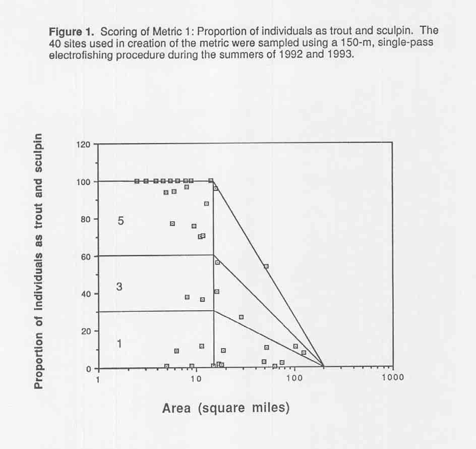
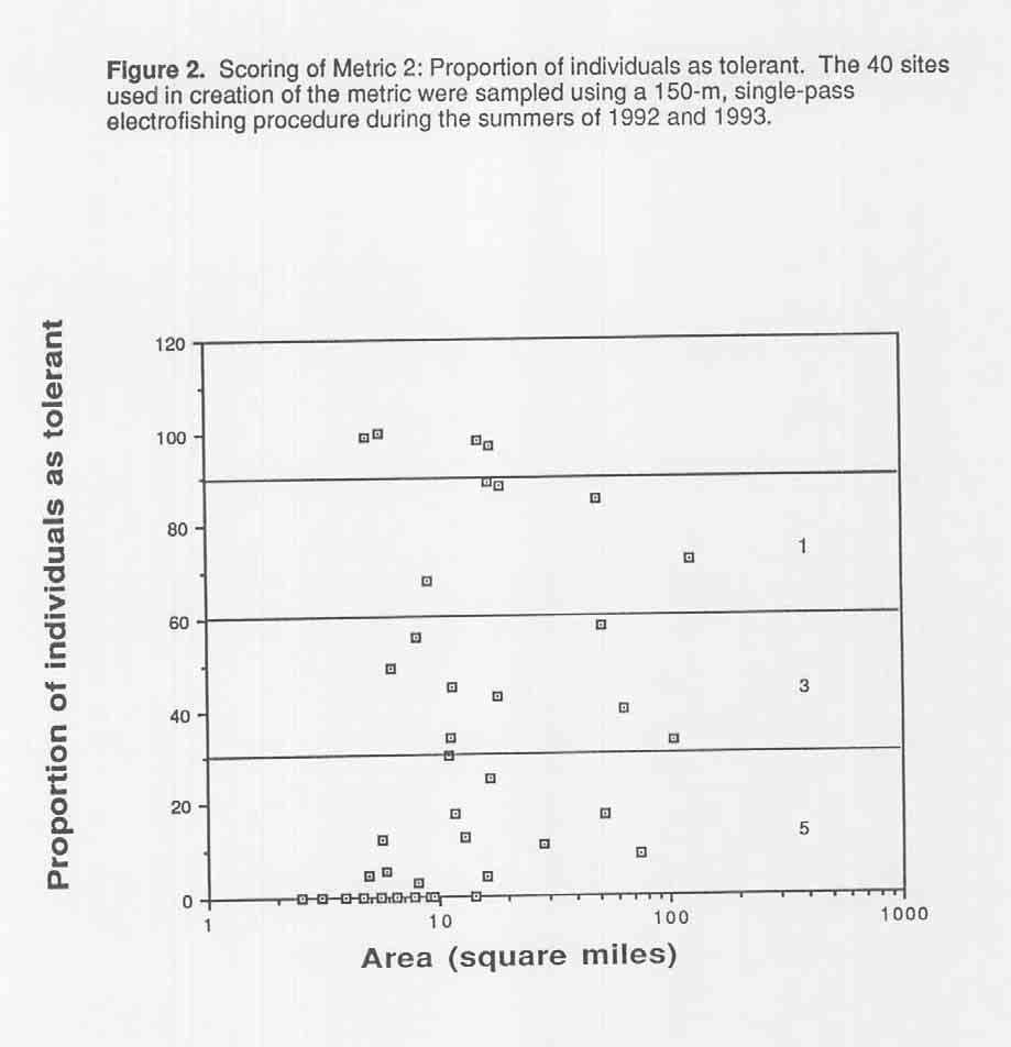
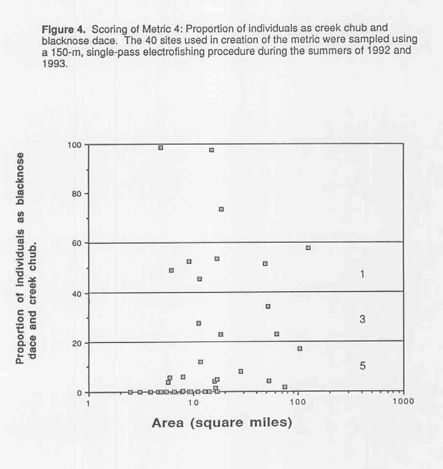
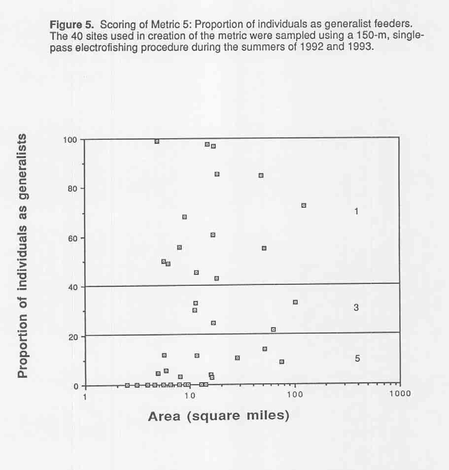
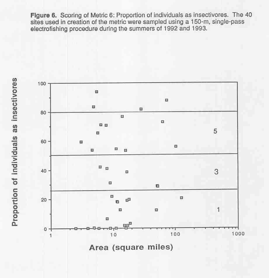
10 Adult trout are the only piscivores in coldwater, southeastern Minnesota streams. Since trout were not measured or aged, proportion of individuals as piscivores was deleted. Number of individuals in a sample was modified to coldwater fish per 150 m. Fish were classified as coldwater based on field observations and range distributions (Lee et al. 1980). Fish classified as coldwater include slimy sculpin, mottled sculpin, American brook lamprey, brown trout, brook trout, rainbow trout, longnose dace and brook stickleback (Table 4). Creek chub and blacknose dace are coldwater fish which were not included in the metric due to their exceptional tolerance to degradation. Both white sucker and johnny darter were species found in greater than 20 sites in southeastern Minnesota streams. However, both species were observed in highest abundance in streams which were not coldwater. In addition, white sucker is a tolerant species. Therefore, neither species was included in the scoring of the metric. Proportion of individuals as hybrids was not used as a metric due to difficulty in recognizing non-centrarchid hybrid species in the field. Proportion of individuals with anomalies was retained as used by Karr (1981). Scoring the metrics Metrics were scored using the procedure outlined by Karr (1991). All metrics were plotted against the log transformation of watershed area, and if any correlation was apparent, a maximum expected value line was drawn to include 90% of the reference data points. The area under the line was then subdivided into three equal areas. The areas were assigned numerical values of 5 (good), 3 (fair), or 1 (poor). During instances in which no correlation with watershed area was apparent, the alternate trisection method was used. A horizontal line containing approximately 95% of the points was drawn, and the area under the line was then trisected. Numerous possibilities occurred in placing the lines drawn during scoring of the metrics. Therefore, best professional judgment and other literature values were referenced.
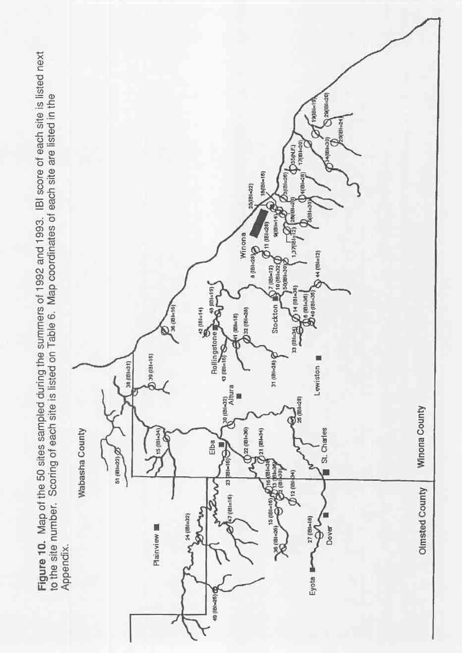
11 Metric 1 (proportion of individuals as trout and sculpin) appeared negatively correlated with watershed areas greater than 17 square miles (Figure 1). Below 17square miles, scoring was held constant. Metrics 2-5 (proportion of individuals as tolerant, proportion of individuals as creek chub and blacknose dace, proportion of individuals as generalist feeders, and proportion of individuals as insectivores) did not appear correlated with watershed area (Figures 2, 4-6). Therefore, those metrics were scored using the alternative trisection method. Metric 6 (proportion of individuals as intolerant) appeared positively correlated with watershed area (Figure 3). Metric 7 (coldwater fishes per 150 m) appeared negatively correlated with watershed areas greater than 11 square miles (Figure 7). Metric 8 (proportion of individuals with anomalies) was scored using proportions determined by Leonard and Orth (1986) (Figure 8). The coldwater, southeastern Minnesota IBI utilized eight metrics, thus the range of possible IBI scores was from 8 to 40. IBI scores of the sites were categorized into their respective integrity classes based upon the percentages that Karr et al. (1986) used for the 12-metric, midwestern U.S. warmwater IBI. Therefore, a score of was assigned the integrity class of "excellent" (Table 5). The integrity class of "good" ranged from 38-32, and "fair" ranged from 31 to 27. IBI scores assigned to the integrity class of "poor" and "very poor" ranged from and 18-8, respectively. Scoring of sites used in creation of the coldwater IBI IBI scores of the 40 sites used in creating the coldwater IBI ranged from 12 to 38 (Figures 9-10, Table 6). Warmwater sites, not used in creation of the index, received coldwater IBI scores ranging from 12 to 31 (Table 6). IBI scores of the 40 sites, with and without the warmwater sites, were plotted against watershed area on Figures 11 and 12. Based on visual observations and invertebrate studies from Boxrud and Gallagher (1992), sites chosen as being representative of the best streams in the area included Garvin Brook (sites 6,13,40), and Beaver Creek (site 45). Furthermore, sites assumed to be representative of non-degraded waters had
12 IBI scores of 32 or higher, which is characteristic of "good" water quality. Based on visual observations, sites assumed to be extremely degraded included a stream which runs through Latsch State Park (site 36), Big Trout Creek (site 20), and West Burns Valley Creek (site 37). These sites all had IBI scores of less than 18, which is characteristic of streams with very poor biotic health. The scoring of sites on the Whitewater River system was supported by the findings of Boxrud and Gallagher's (1992) invertebrate studies. In the best professional judgment of the author of the present study, the coldwater IBI appeared to assign sites used in creation of the index to appropriate integrity classes. IBI scores of the sites from Quinn (1994) ranged from 16 to 34 (Table 7). Little variability was apparent between rehabilitated (improved) and unrehabilitated (reference) sites within four of the five streams. However, in the improvement project at the Middle Branch of the Whitewater River, 1131 scores were higher at rehabilitated sites than at unrehabilitated sites. The two unrehabilitated sites were upstream from the two rehabilitated sites. Both upstream, unrehabilitated sites scored "poor" on the IBI ratings (scores of 24 and 26). The downstream rehabilitated sites had IBI scores of 32 and 34, which are indicative of "good" water quality and habitat availability. Boxrud and Gallagher (1992) found a rehabilitated stream section of the Middle Branch of the Whitewater River contained better habitat for stream invertebrates than an upstream, unrehabilitated site. In addition, Boxrud and Gallagher (1992) found stream quality for invertebrates at a downstream, unrehabilitated site was like that of the rehabilitated section. That downstream site (site 16) scored the highest IBI (IBI = 38) value of any stream in southeastern Minnesota that was examined. The coldwater IBI was applied to 13 data sets, collected at two sites on Gilmore Creek during the months of June and October, between 1991 and 1993 (Table 8). Scores from the upstream Wildwood Road sites ranged from 28 to 30, and the scores from the downstream St. Mary's site ranged from 26 to 30. Comparatively, the site used in creation of the IBI at Wildwood
13 Road sampled during July 1992 scored 32 (Figure 13). Gilmore Creek endured no major visually obvious changes between the time period from 1991 to present, thus it was expected that IBI scores of the two sites would remain relatively constant over time. The Wildwood Road site varied little over seven differing sampling occasions between June 13, 1991 to October 5, In addition, IBI scores of the site near St. Mary's College varied little between five independent samplings during The coldwater IBI was applied to four independent sites on the South Branch of the Whitewater River, which were sampled on September 25 and October 2, 1990 (Table 8). All sites lacked trout, so the sites served as warmwater references. The site furthest downstream, scored the highest value of the four sites (IBI = 26). Both sites in the middle reaches of the stream had calculated IBI scores of 14. The furthest upstream site scored the lowest of the South Branch independent sites, having an IBI score of 10. Streams, under normal circumstances, should exhibit a continuum of decreasing IBI scores from upstream to downstream. However, the independent sites on the South Branch of the Whitewater River exhibited higher IBI scores downstream and lower scores upstream. The stream's headwaters are located on an agricultural plain, and as the stream proceeds downstream, it enters the forested Whitewater Wildlife Management Area. As the stream enters the management area, it appeared that effects from increased shading and small, coldwater tributaries provided better coldwater habitat downstream. Also, the furthest downstream site contained trout during a later sampling occasion used in creation of the coldwater IBI. Furthermore, the banks of the stream within Whitewater Wildlife Management Area are not continually degraded by the immediate activities of cattle. Thus, biotic conditions of the stream appeared better for coldwater fish communities downstream. The coldwater IBI was applied to one independent site on Pleasant Valley Creek (Table 8). The site scored an IBI of 26 (poor). A separate sampling occasion used in creation of the coldwater IBI (site 4) at the same locality, which was sampled before the independent occasion,
14 received an IBI score of 28 (fair). The decreased IBI score of the second sampling occasion was expected because the riparian corridor of the stream experienced increased housing development during the time period between the two samplings (N. Mundahl, personal communication). In addition, the stream bed was observed as having higher quantities of sand and silt during the second sampling occasion (N. Mundahl, personal communication). IBI scores of the 40 coldwater sites used in creation of the index were plotted against each metric (Table 9; Figures 13-20). Proportion of individuals as tolerant (metric 2) and proportion of individuals as generalist feeders (metric 5) individually explained 77% and 76% of the variability in the coldwater IBI, respectively (Figures 14, 17). Metrics created for the coldwater IBI, metrics 1(proportion of individuals as trout and sculpin), 4 (proportion of individuals as creek chubs and blacknose dace), and 7 (coldwater fish per 150 m), individually explained 49%, 62%, and 37% of the variability in the coldwater IBI, respectively (Figures 1,16,19). Therefore, all metrics created during the present study appear to contribute to the IBI. Proportion of individuals as insectivores explained 28% of the variability in the coldwater IBI (Figure 18). Both proportion of individuals as intolerant and proportion of individuals with anomalies explained little variability in the coldwater IBI (Figures 15, 20). The present study proposes a basis for stream managers to assess changes in the biotic health of southeastern Minnesota's coldwater streams. However, since the index was created and applied to a limited number of sites, further validation of the metrics proposed during the present study is needed. In particular, proportion of individuals as intolerant should be scrutinized. Karr et al. (1986) listed mottled sculpin as an intolerant species. However, during the present study sculpin were not used as intolerant fish because other literature did not list sculpin as intolerant, and they were prominent in the scoring of three other metrics. Also, the intolerant metric should be further examined during future studies to determine if higher-gradient streams are more likely to contain coldwater, intolerant fish. Both intolerant species used in the present study, longnose dace and American brook lamprey, were observed most frequently in streams with higher-gradients. Only
15 further study will elucidate the true value of the metrics used during the course of the present study. Furthermore, the southeastern Minnesota coldwater IBI should only be tested by experienced aquatic biologists, because no management device can "substitute for the knowledge and expertise of an experienced, well informed stream ecologist when it comes to stewardship of our flowing waters" (Kwak 1993). Literature Cited Bailey, P.A., K.W. Enblom, S.R. Hanson, and P.A. Renard A fish community analysis of the Minnesota River Watershed: preliminary report. Minnesota Pollution Control Agency, St. Paul. 121 p. Internship report. Winona State University, Winona, MN Eddy, S. and J.C. Underhill How to know the freshwater fishes. W.C. Brown. Co., Dubuque, IA. 215 p. Karr, J.R Assessment of biotic integrity using fish communities. Fisheries 6: Karr, J.R., K.D. Fausch, P.L. Angermeier, P.R. Yant, and I.J. Schlosser Assessing biological integrity in running waters: a method and its rationale. Illinois Natural History Survey. Special Publication 5. Champaign, Illinois Karr, J.R Biological integrity: a long-neglected aspect of water resource management. Ecological Applications 1: Kwak, T.J Influence of physical and biotic factors on trout production dynamics in southeastern Minnesota. Ph.D. Dissertation. University of Minnesota. St. Paul, MN. 205 p. Lee, D.S., C.R. Gilbert, C.H. Hocutt, R.E. Jenkins, D.E. McAllister, and J.R. Stauffer, Jr Atlas of North American Freshwater Fishes. North Carolina State Museum of Natural History. 867 p. Leonard, P.M. and D.J. Orth Application and testing of an Index of Biotic Integrity in small, coolwater streams. Transactions of the American Fisheries Society. 115: Miller, D.L., P.M. Leonard, R.M. Hughes, J.R. Karr, P.B. Moyle, L.H.Schrader, B.A. Thompson, R.A. Daniels, K.D. Fausch, G.A. Fitshugh, J.R. Gammon, D.B. Haliwell, P.L. Angermeier, and K.J. Orth Regional applications of an index of biotic integrity for use in water resource management. Fisheries 13: Mundahl, N.D., K.L. Gallagher, D.E. Boxrud, and A.M. Bilicki A preliminary assessment of fish communities in the Whitewater River, with special emphasis on the Middle Branch. Department of Biology. Winona State University. Winona, MN.
16 Ohio EPA Biological criteria for the protection of aquatic life: Volume II. Users manual for biological field assessment of Ohio waters. Ohio Environmental Protection Agency, Columbus. Quinn, J.W Effects of trout rehabilitation projects on nongame fish communities in five southeastern Minnesota streams. Department of Biology. Winona State University. Winona, MN. Troelstrup, N.H. and J.A. Perry Water quality in southeastern Minnesota streams: observations along a gradient of land use and geology. Journal of the Minnesota Academy of Science 55 (1): Steedman, R.J Modification and assessment of an index of biotic integrity to quantify stream quality in southern Ontario. Can. J. Fish. Aquat. Sci. 45: Vannote, R.L. G.W. Minshall, K.W. Cummins, J.R. Sedell, and C.E. Cushing The River Continuum Concept. Can. J. Fish. Aquat. Sci. 37:
17 Table 1. Species collected at 51 sites in Winona, Wabasha, and Olmsted counties, MN, during the summers of Fish were sampled using a 150-m, single-pass electrofishing procedure. Scientific name Common name Family name Number of sites captured Ameiurus melas Black bullhead Ictaluridae 1 Ameiurus natalis Yellow bullhead Ictaluridae 2 Campostoma anomalum Central stoneroller Cyprinidae 7 Catostomus commersoni White sucker Catostomidae 28 Cottus bairdl Mottled sculpin Cottidae 5 Cottus cognatus Slimy sculpin Cottidae 6 Culaea inconstans Brook stickleback Gasterosteidae 13 Etheostoma asprigene Mud darter Percidae 1 Etheostoma caeruleum Rainbow darter Percidae 2 Etheostoma flabellare Fantail darter Percidae 11 Etheostoma nigrum Johnny darter Percidae 20 Lampetra appendix American brook lamprey Petromyzontidae 3 Lepomis cyanellus Green sunfish Percidae 4 Lepomis macrochirus Bluegill sunfish Percidae 2 Luxilus cornutus Common shiner Cyprinidae 4 Notropis dorsalis Bigmouth shiner Cyprinidae 1 Noturus gyrinus Tadpole madtom Ictaluridae 1 Oncorhynchus mykiss Rainbow trout Salmonidae 1 Percina caprodes Logperch Percidae 1 Phoxinus erythrogaster Southern redbelly dace Cyprinidae 3 Pimephales notatus Bluntnose minnow Cyprinidae 6 Rhinichthys atratulus Blacknose dace Cyprinidae 32 Rhinichthys cataractae Longnose dace Cyprinidae 21 Salmo trutta Brown trout Salmonidae 37 Salvelinus fontinalis Brook trout Salmonidae 9 Semotilus atromaculatus Creek chub Cypdnidae 24 Umbra limi Central mudminnow Cyprinidae 6
18 Table 2. Metrics used by Karr (1986) to assess fish communities in the midwestern United States. Category l Metric Species richness and composition 1. Total number of fish species. 2. Number and identity of darter species. 3. Number and identity of sunfish species. 4. Number and identity of sucker species. 5. Proportion of individuals as intolerant. 6. Proportion of individuals as green sunfish. Trophic composition 7. Proportion of individuals as omnivores. 8. Proportion of individuals as insectivorous cyprinids. 9. Proportion of individuals as piscivores. Fish abundance and condition 10. Number of individuals in a sample. 11. Proportion of individuals as hybrids. 12. Proportion of individuals with anomalies.
19 Table 3. IBI metrics used to assess stream fish communities in cold water, southeastern Minnesota streams. Scoring criteria 4 Category Metric Species composition: 1. Proportion of individuals as see Figure 1 trout and sculpin 2. Proportion of individuals as <30% 30-60% >60% tolerant. 3. Proportion of individuals as see Figure 3 intolerant. 4. Proportion of individuals as <20% 20-40% >40% creek chubs and blacknose dace. Trophic composition: 5. Proportion of individuals as <20% 20-40% >40% generalist feeders. 6. Proportion of individuals as >50% 25-50% <25% insectivores. Fish abundance and condition: 7. Coldwater fish per 150 m. see Figure 7 8. Proportion of individuals <0.5% % <1 with anomalies.
20 Table 4. Classification of fishes captured in southeastern Minnesota during summer 1992, Insectivore G - Generalist T - Tolerant R - Intolerant C - Coldwater fish * not used in calculations due to exceptionally tolerant status. Scientific name Common name Trophic guild Tolerance Cold water fish Ameiurus melas Black bullhead I T Ameiurus natalis Yellow bullhead I T Campostoma anomalum Central stoneroller Catostomus commersoni White sucker G T Cottus bairdi Mottled sculpin I C Cottus cognatus Slimy sculpin I C Culaea inconstans Brook stickleback I C Etheostoma asprigene Mud darter Etheostoma caeruleum Rainbow darter I Etheostoma flabellare Fantail darter I Etheostoma nigrum Johnny darter I Lampetra appendix American brook lamprey R C Lepomis cyanellus Green sunfish G T Lepomis macrochirus Bluegill sunfish I Luxilus comutus Common shiner I Notropis dorsalis Bigmouth shiner I Noturus gydnus Tadpole madtom Oncorhynchus mykiss Rainbow trout C Percina caprodes Logperch I Phoxinus erythrogasfer Southern redbelly dace Pimephales notatus Bluntnose minnow G Rhinichthys atratulus Blacknose dace G T C* Rhinichthys cataractae Longnose dace I T C Salmo trutta Brown trout R C Salvelinus fontinalis Brook trout C Semotilus atromaculatus Creek chub G T C* Umbra limi Central mudminnow I T
21 Table 5. Description of integrity classes. Modified from Karr et al. (1986) g Total IBI score Integrity class Attributes d Excellent - Comparable to the best situations without human disturbance. The most intolerant forms are present; balanced trophic structure Good - Partial or complete loss of most intolerant forms; trophic structure shows signs of stress; coldwater fish abundance less than optimal Fair - Intolerant forms absent. Increasing proportions of warmwater species; highly skewed trophic structure Poor - Dominated by generalist feeders and tolerant forms; severe reduction in abundance of nontolerant coldwater fish; anomalies may by present 8-18 Very poor - Few fish present, mostly generalist feeders tolerant forms; anomalies common
22 Table 6. IBI scoring of the 51 sites used in creation of the coldwater IBI. Sites were sampled using a 150-m, single pass electrofishing procedure during the summers of 1992 and Metric used in scoring are listed on Table 3. Location of the sites are shown on Figure 10. Sites with an asterisk are warmwater, and were only used as references. Site ml m2 m3 m4 m5 m6 m7 m8 Total 1* * * * * * * * * * *
23 Table 7. IBI scores of independent sites studied by Quinn (1994). All sites were sampled during summer Metrics used in scoring the sites are listed on Table 3. Site m1 m2 m3 m4 m5 m6 m7 m8 IBI Score Garvin Brook: Improved Reference Reference # Little Trout Creek: Improved Reference Big Trout Creek: Improved Reference Reference West Indian Creek: Improved Reference Middle Branch of the Whitewater River: Improved Reference Improved # Reference #
24 Table 8. IBI scores from independent sites obtained from Dr. Neal Mundahl. The South Branch of the Whitewater River sites were sampled from September 25 and October 2, Metrics used in scoring the sites are listed on Table 3. Site Date sampled m1 m2 m3 m4 m5 m6 m7 m8 IBI score Pleasant Valley Creek Gilmore Creek Wildwood road: St. Mary's: South Branch of the Whitewater River Site Site Site Site
25 Table 9. Percent variability in the coldwater IBI explained by each individual metric. Metric Percent explained 2 Metric 1: proportion of individuals as 49.4 trout and sculpin Metric 2: proportion of individuals as 76.9 tolerant Metric 3: proportion of individuals as 4.70 intolerant Metric 4: proportion of individuals as 62.2 creek chub and blacknose dace Metric 5: proportion of individuals as 76.3 generalists Metric 6: proportion of individuals as 27.7 insectivores Metric 7: coldwater fish per 150 m 37.4 Metric 8: proportion of individuals 1.30 with anomalies
26
27

28
29
30
31
32
33
34
35
36
37
38
39
40
41
42
43 Appendix 1. Map coordinates of the sites used in creation of the coldwater, southeastern Minnesota IBI. Site Stream Map Coordinates Date sampled 1 West Burns Valley Creek T1 06N RAW S3 6/25/92 2 Middle Branch of the Whitewater River T1 07N R11 W S35 6/26/92 3 Pleasant Valley Creek T106N R7W S1 7/1/92 4 Pleasant Valley Creek TI 06N R7W S12 7/1/92 5 East Burns Valley Creek T1 06N R7W S10 7/6/92 6 Garvin Brook TI 06N R8W S8 7/7/92 7 Garvin Brook TI 07N R8W S34 7/8/92 8 Gilmore Creek T107N R7W S20 7/9/92 9 Main Burns Valley Creek T107N R7W S36 7/10/92 10 Gilmore Creek T107N R7W S31 7/15/92 11 Gilmore Creek TI 07N R7W S29 7/16/92 12 Middle Branch of the Whitewater River T106N R11 W S3 7/17/92 13 Middle Branch of the Whitewater River T107N R11 W S35 7/17/92 14 Garvin Brook T106N R8W S5 7/28/92 15 Warmwater Trib. of M.B.W.W. River T107N R11W S32 7/29/92 16 Middle Branch of the Whitewater River TI 07N R11 W S26 7/29/92 17 Cedar Creek T1 06N R6W S11 7/30/92 18 Main Burns Valley Creek T1 07N R7W S36 7/31/92 19 Big Trout Creek T106N R6W S13 8/3/92 20 Big Trout Creek T106N R6W S23 8/4/92 21 Trout Run Creek Ti 07N R10W S29 8/5/92 22 Middle Branch of the Whitewater River TI 07N R10W S20 8/5/92 23 North Branch of the Whitewater River T107N R10W S8 8/10/92 24 North Branch of the Whitewater River T1 08N R11 W S32 9/10/92 25 Main Burns Valley Creek T107N R7W S36 8/11 /92 26 South Branch of the Whitewater River T106N R10W S2 8/12/92 27 South Branch of the Whitewater River T106N R11 W S20 8/12/92 28 Bums Valley Creek T107N R7W S35 8/17/92 29 Little Trout Creek TI 06N R5W S19 8/20/92 30 South Branch of the Whitewater River T107N R10W S14 8/24/92 31 Rupprecht Creek T1 07N R9W S35 NE 1/4 6/15/93 32 Rupprecht Creek T1 07N R9W S24 NE 1/4 6/16/93 33 Peterson Creek TI 06N R8W S7 NE 1/4 6/21/93 34 Cedar Creek TI 06N R6W S28 NW 1/4 6/23/93 35 Homer Creek T106N R6W S9 NW 1/4 6/24/93 36 Latsch State Park Creek T108N R9W S12 NE 1/4 6/28/93 37 West Burns Valley Creek T107 R5W S4 SE 1/4 6/28/93 38 Trout Creek T108 R9W S5 NW 1/4 7/1/93 39 Trout Creek T108 R9W S17 NW 1/4 7/1/93 40 Garvin Brook T108 R5W S8 SW 1/4 7/6/93 41 Bear Creek T108 R6W S13 NW 1/4 7/7/93 42 Speltz Creek T108 R8W S31 SE 1/4 7/9/93 43 Straight Valley Creek T108 R9W S11 NE 1/4 7/22/93 44 Stockton Creek T106 R8W S14 NE 1/4 7/28/93 45 Beaver Creek T108N R10W S15 SW 1/4 8/2/93 46 Warmwater Trib. MBWW River T106 RI 2W S1 NE 1/4 8/5/93 47 Logan Creek T107 RI 1W S8 SE 1/4 8/10/93 48 Rollingstone Creek T107 R8W S4 SW 1/4 8/12/93 49 North Branch of the Whitewater River T107 R1 2W S4 SW 1/4 8/13/93 50 Gilmore Creek T107N R7W S31 SE 1/4 8/19/93 51 East Indian Creek T109 R10W S29 SE 1/4 8/25/93
Conewago Creek Initiative. Fish Survey Report for the Conewago Creek
 Conewago Creek Initiative Fish Survey Report for the Conewago Creek A compilation of historic fish survey data from 97, 973, 7, for three locations along the Conewago Creek Prepared by Kristen Kyler for
Conewago Creek Initiative
 Conewago Creek Initiative The Conewago Creek Revisited Fish Survey Report A compilation of historic fish survey data from 197, 1973, 7, 1, and 15 for three locations along the Conewago Creek Prepared by
BA1 BA2 BA3 BA4 BA5 BA6 CP1 CP2 CP3 CP4 CP5 CP6
 Table 1: Results of fish collections within or adjacent to the Boyne Secondary Plan Area conducted by C. Portt and Associates. Station locations are provided in Figure 1. Stations BA1-BA6 were collected
OHIO DEPARTMENT OF TRANSPORTATION Division of Planning, Office of Environmental Services 1980 West Broad Street, Columbus, Ohio 43223
 August 06, 2007 OHIO DEPARTMENT OF TRANSPORTATION Division of Planning, Office of Environmental Services 1980 West Broad Street, Columbus, Ohio 43223 U.S. Army Corps of Engineers Ohio Regulatory Transportation
FISHES OF THE KNIFE LAKE WATERSHED IN KANABEC AND MILLE LACS COUNTIES OF MINNESOTA. Konrad Schmidt, Vice-President
 Conservation Biology Research Grants Program Division of Ecological Services Minnesota Department of Natural Resources FISHES OF THE KNIFE LAKE WATERSHED IN KANABEC AND MILLE LACS COUNTIES OF MINNESOTA
Preakness Brook - FIBI098
 Preakness Brook - FIBI098 Preakn ess B rook Preakness " ( FIBI098 Naachtpunkt Brook 202 80 IBI Ratings FIBI Sampling Location Excellent Small Streams (1st and 2nd Order) Good Fair Large Streams (3rd Order
SUMMARY OF RESULTS FIBI054
 SUMMARY OF RESULTS FIBI054 1. Stream Name: Lamington River 2. Sampling Date: 7/10/2007 3. Sampling Location: McCann Mill Road 4. Municipality Tewksbury Township 5. County: Hunterdon 6. Watershed Management
Beaver Brook - FIBI047 Hope
 Beaver Brook - FIBI047.-,80 Silve r Lake Mud dy Br ook % Hope Honey Run Beaver Brook FIBI047 #S #S FIBI Sampling Location Small Streams (1st and 2nd Order) Large Streams (3rd Order and Above) N 0 1 2 3
Montgomery Parks Biological Monitoring in the Anacostia Watershed of Montgomery County RESOURCE ANALYSIS SECTION
 Montgomery Parks Biological Monitoring in the Anacostia Watershed of Montgomery County PARK PLANNING & STEWARDSHIP Doug Redmond, Natural Resources Manager Montgomery County Department of Parks September
EFFECTS OF TROUT STREAM HABITAT REHABILITATION PROJECTS ON NONGAME FISH COMMUNITIES IN FIVE SOUTHEASTERN MINNESOTA STREAMS. Jeffrey W.
 Conservation Biology Research Grants Program Division of Ecological Services Minnesota Department of Natural Resources EFFECTS OF TROUT STREAM HABITAT REHABILITATION PROJECTS ON NONGAME FISH COMMUNITIES
Pohatcong Creek - FIBI033
 DELAWARE RIVER Pohatcong Creek - FIBI033 Drainage Area of FIBI033: 9.8 Square Miles Surface Water Quality Classification of FIBI033: FW2-TM Washington #S "! 3 1 % P ohatcong Creek FIBI033 "! 57 Merri l
Fish faunal changes in Otsego Lake s Shadow Brook watershed following application of best management practices
 Fish faunal changes in Otsego Lake s Shadow Brook watershed following application of best management practices Ryan J. Reynolds 1, Joseph C. Lydon 2 and John R. Foster 3 Abstract: This study was conducted
Little Flat Brook - FIBI065
 Little Flat Brook - FIBI065 Beerskill Cre ek 15 FIBI065 Little Flat Br ook Layton 15 FIBI Sampling Location Small Streams (1st and 2nd Order) Large Streams (3rd Order and Above) SUMMARY OF RESULTS FIBI065
Rouge Fish Surveys
 Rouge Fish Surveys 2011-16 Friends of the Rouge January 2017 Partially funded by the Areas of Concern Program Office of the Great Lakes (OGL), DEQ Additional data provided by MDNR and MDEQ Fall 2016 Sampling
Full Project Proposal
 PROJECT NAME: FIELD OFFICE: Full Project Proposal NFPP Phase I - Ferson-Otter Creek Dam Removal/Modification Project, Fox River Watershed, Illinois Carterville NFWCO PROJECT COORDINATOR: Nate Caswell FONS
F I B I ST 519 OP 57. [ Excellent [ Fair. [ Poor. U p p e r D e l a w a r e W M A 1. C e n t r a l D e l a w a r e W M A 1 1.
 L o p a t c o n g C r e e k F I B I 0 0 4 # Allens Mills Uniontown # ST 519 U p p e r D e l a w a r e W M A 1 Lopatcong Creek 22 OP 57 [ 78 Still Valley # C e n t r a l D e l a w a r e W M A 1 1 FIBI Rating
[ # [ Excellent [ Fair. Upper Delaware WMA 1. North and South Branch Raritan WMA 8. Holland. Milford FIBI026. Frenchtown. Central Delaware WMA 11
 North and Sou Upper Delaware WMA 1 North and South Branch Raritan WMA 8 Holland # # Milford [ # FIBI026 Frenchtown Central Delaware WMA 11 FIBI Rating [ Excellent [ Fair [ Good [ Poor Stream Order 1st,
Cool (or Warm-transitional) Stream
 Stream") Cool (or Warm-transitional) Stream A Brief Ecological Description of this Michigan River Type Cool Stream segments are defined (by the Michigan Department of Natural Resources, Fisheries Division) as typically
Cool (or Warm-transitional) Stream A Brief Ecological Description of this Michigan River Type Cool Stream segments are defined (by the Michigan Department of Natural Resources, Fisheries Division) as typically
Evaluation of Newbury Weirs (Rock Riffles) for Improving Habitat Quality and Biotic Diversity in Illinois Streams.
 for Improving Habitat Quality and Biotic Diversity in Illinois Streams.") Evaluation of Newbury Weirs (Rock Riffles) for Improving Habitat Quality and Biotic Diversity in Illinois Streams. Report submitted to The Wildlife Preservation Fund Illinois Department of Natural Resources
Evaluation of Newbury Weirs (Rock Riffles) for Improving Habitat Quality and Biotic Diversity in Illinois Streams. Report submitted to The Wildlife Preservation Fund Illinois Department of Natural Resources
SUMMARY OF RESULTS FIBI098
 SUMMARY OF RESULTS FIBI098 1. Stream Name: Preakness Brook 2. Sampling Date: 7/9/2009 3. Sampling Location: Preakness Avenue 4. Municipality Totowa 5. County: Passaic 6. Watershed Management Area: 4 7.
Thunder Bay River Assessment Appendix. Appendix 2
 Appendix 2 Known past and present fish distributions in the River system. Distribution of fishes were compiled from Bailey et al. (2003) and from records located at the Michigan Department of Natural Resources
American Currents Spring 1993 Vol 19 No 1
 -22- PUTTING BACK THE PIECES by Konrad Schmidt, St. Paul, Minnesota The Knife River meanders some 25 miles through small farms and woodlands in east central Minnesota before joining the Snake River near
Fisheries Review with Respect to Stormwater Management for Milton/Navan Road Property
 Fax: 613.935.6295 Mr. Jean-Luc Rivard 3223701 CANADA INC. 98 rue Lois Gatineau, QC J8Y 3R7 July 23, 2014 Re.: Fisheries Review with Respect to Stormwater Management for Milton/Navan Road Property Mr. Rivard:
Minnesota Department of Natural Resources Division of Fish and Wildlife Section of Fisheries. Stream Survey Report. Three Mile Creek 2011
 Minnesota Department of Natural Resources Division of Fish and Wildlife Section of Fisheries Stream Survey Report Three Mile Creek 2011 By Joseph D. Stewig Montrose Area Fisheries Office TABLE OF CONTENTS
Fish community assessment in the Harpeth River prior to the removal of the dam at Franklin, TN
 Fish community assessment in the Harpeth River prior to the removal of the dam at Franklin, TN Submitted to Dorie Bolze, Harpeth River Watershed Association By Frank Fiss and Nathan Singer, Tennessee Wildlife
Proposed Reclassification of Cherry Creek, North Platte River Basin, Wyoming. October 25, 2010
 Proposed Reclassification of Cherry Creek, North Platte River Basin, Wyoming October 25, 2010 Waterbody: Location: Tributary to: Cherry Creek - Mainstem from headwaters downstream to the confluence with
Cold-transitional Stream
 Cold-transitional Stream A Brief Ecological Description of this Michigan River Type Cold-transitional Stream segments are defined (by the Michigan Department of Natural Resources, Fisheries Division) as
[ Excellent [ Fair. Millbrook FIBI039. Calno. Upper Delaware WMA 1. Pahaquarry. Stream Order 1st, 2nd & 3rd Order. FIBI Rating.
 @ Millbrook [ @ FIBI039 Calno Upper Delaware WMA 1 @ Pahaquarry FIBI Rating [ Excellent [ Fair [ Good [ Poor Stream Order 1st, 2nd & 3rd Order 4th Order & Higher É 0 2 4 Miles SUMMARY OF RESULTS FIBI039
Cold-transitional Small River
 Cold-transitional Small River A Brief Ecological Description of this Michigan River Type Cold-transitional Small River segments are defined (by the Michigan Department of Natural Resources, Fisheries Division)
Warm Stream. A Brief Ecological Description of this Michigan River Type
 Warm Stream A Brief Ecological Description of this Michigan River Type Warm Stream segments are defined (by the Michigan Department of Natural Resources, Fisheries Division) as typically having drainage
(/ North Branch Raritan River - FIBI031 % FIBI031
 North Branch Raritan River - FIBI031 Drainage Area of FIBI031: 172.7 Square Miles Surface Water Quality Classification of FIBI031: FW2-NT.-,7 8.-,287 (/ 20 2 North Branch Raritan Chambers Brook (/ 2 2
Pequannock River - FIBI077
 Pequannock River - FIBI077 Canistear Rsvr. Clint on Brook Clinton R svr. k R r. idge Rs v Echo Lake Oa 23 Pequann ock R iver FIBI077 Kinnelon 287 23 FIBI Sampling Location Small Streams (1st and 2nd Order)
Lake Superior. Ontonagon River Assessment. Ontonagon. Rockland. Victoria Dam. Bergland. Bergland. Dam. Bruce Crossing Agate Falls. Kenton Lower.
 Sand shiner otropis stramineus feeding - sand and gravel substrate - shallow pools in medium size streams, lakes, and impoundments - clear water and low gradient - rooted aquatic vegetation preferred -
Proposed Reclassification of Deer Creek, North Platte River Basin, Wyoming
 Proposed Reclassification of Deer Creek, North Platte River Basin, Wyoming October 25, 2010 Waterbody: Location: Tributary to: Deer Creek - Mainstem from headwaters downstream to the confluence with the
Report prepared for: Prepared by: January 2002 BEAK Ref
 AQUATIC ENVIRONMENTAL STUDY KANATA WEST CONCEPT PLAN Report prepared for: ROBINSON CONSULTANTS Prepared by: BEAK INTERNATIONAL INCORPORATED 14 Abacus Road Brampton, Ontario L6T 5B7 January 2002 BEAK Ref.
Cold Small River. A Brief Ecological Description of this Michigan River Type
 Cold Small River A Brief Ecological Description of this Michigan River Type Cold Small River segments are defined (by the Michigan Department of Natural Resources, Fisheries Division) as typically having
(/ Neshanic River - FIBI023 "! 3 1. ø ø 52 3 ø 57 9 FIBI023
 Neshanic River - FIBI023 Drainage Area of FIBI023: 23.1 Square Miles Surface Water Quality Classification of FIBI023: FW2-NT ø 52 3 ø 57 9 Neshanic River (/ 20 2 FIBI023 % #S Neshanic River Back Brook
Tahquamenon River Assessment Appendix
 DNR DEPARTMENT OF NATURAL RESOURCES MICHIGAN STATE OF MICHIGAN DEPARTMENT OF NATURAL RESOURCES SR45 Appendix February 2008 Tahquamenon River Assessment Appendix James R. Waybrant and Troy G. Zorn www.michigan.gov/dnr/
Using Habitat Guilds to Develop Habitat Suitability Criteria for a Warmwater Stream Fish Assemblage. Jason Persinger, Don Orth,, Tammy Newcomb
 Using Habitat Guilds to Develop Habitat Suitability Criteria for a Warmwater Stream Fish Assemblage Jason Persinger, Don Orth,, Tammy Newcomb Shenandoah River Basin North Fork Shenandoah River 20% discharge
PA FISH AND BOAT COMMISSION COMMENTS AND RECOMMENDATIONS February 16, Tributaries to the Tioga-Hammond Lake Complex (404A)
") PA FISH AND BOAT COMMISSION COMMENTS AND RECOMMENDATIONS February 16, 2012 WATER: Tributaries to the Tioga-Hammond Lake Complex (404A) EXAMINED: July - August 2007 BY: Wnuk, Frey, and Koser Bureau Director
PA FISH AND BOAT COMMISSION COMMENTS AND RECOMMENDATIONS February 16, 2012 WATER: Tributaries to the Tioga-Hammond Lake Complex (404A) EXAMINED: July - August 2007 BY: Wnuk, Frey, and Koser Bureau Director
Introduction. Fluvial Geomorphology Hydrogeology. to minimize the consumption of paper resources.
 Duffins Creek State of the Watershed Report Aquatic Habitat and Species June 2002 Other topics in this series for both the Duffins Creek and the Carruthers Creek include: Introduction Study Area Human
STUDY PERFORMANCE REPORT
 STUDY PERFORMANCE REPORT State: Michigan Project No.: F-80-R-7 Study No.: 230654 Title: Evaluation of brown trout and steelhead competitive interactions in Hunt Creek, Michigan. Period Covered: October
HURON RIVER WATERSHED
 Brown bullhead (Ameiurus nebulosus) feeding - larger streams and rivers, lakes and impoundments - clear cool water with little clayey silt - moderate amounts of aquatic vegetation - sand, gravel, or muck
THE MYSTERY CAVE EXPEDITIONS by Konrad Schmidt, Saint Paul, Minnesota
 -26- THE MYSTERY CAVE EXPEDITIONS by Konrad Schmidt, Saint Paul, Minnesota Mystery Cave, located about 7 miles southeast of Spring Valley in southeastern Minnesota, was purchased in 1988 as an addition
Trip Report: Eagle Creek, Arizona
 Trip Report: Eagle Creek, Arizona 15-17 June 2009 Participants: Abraham Karam, Brian Kesner, and Mike Childs Native Fish Lab Marsh & Associates, LLC 5016 South Ash Avenue Suite 108 Tempe, Arizona 85282
Alberta Conservation Association 2017/18 Project Summary Report
 Alberta Conservation Association 2017/18 Project Summary Report Project Name: Abundance, Distribution, Spawning, and Thermal Habitat of Westslope Cutthroat Trout and Bull Trout in the Stimson Creek Watershed
Michigan Department of Natural Resources Status of the Fishery Resource Report Page 1
 Michigan Department of Natural Resources 2008-59 Status of the Fishery Resource Report Page 1 Bowens Manistee County, (T24N R16W Sec. 11, 12, 13, 14, 15, 24, and 30). Last surveyed 2008 Mark A. Tonello
Target Fish Communities and the MA Water Policy
 Target Fish Communities and the MA Water Policy Todd Richards MA Division of Fisheries and Wildlife Todd.Richards@state.ma.us MA Water Policy (2004) Principle: Protect Fish and Wildlife Habitat Recommendation:
Proposed Reclassification of Horse Creek, North Platte River Basin in Goshen County, Wyoming
 Proposed Reclassification of Horse Creek, North Platte River Basin in Goshen County, Wyoming October 25, 2010 Waterbody: Location: Tributary to: Horse Creek - Mainstem from the confluence with Stinking
Manistee River Assessment Appendix
 DNR STATE OF MICHIGAN DEPARTMENT OF NATURAL RESOURCES Number 21 June 1998 River Assessment Appendix Thomas J. Rozich www.dnr.state.mi.us FISHERIES DIVISION SPECIAL REPORT MICHIGAN DEPARTMENT OF NATURAL
Minnesota Department of Natural Resources Division of Fish and Wildlife Section of Fisheries. Stream Survey Report. Luxemburg Creek.
 Minnesota F-29-R(P)-24 Area 315 Study 3 March 2016 Minnesota Department of Natural Resources Division of Fish and Wildlife Section of Fisheries Stream Survey Report Luxemburg Creek 2015 Mark Pelham Sauk
SUMMARY REPORT FOR LAKE ST. MALO FISHERIES ASSESSMENT. Prepared for the St. Malo and District Wildlife Association
 SUMMARY REPORT FOR LAKE ST. MALO FISHERIES ASSESSMENT Prepared for the St. Malo and District Wildlife Association Presented by August 25, 2014 Study dates thus far: Date Tasks February 16 Fishing derby;
Assessing the Sustainability ad Biological Integrity of Water Resources Using Fish Communities
 Assessing the Sustainability ad Biological Integrity of Water Resources Using Fish Communities Edited by CRC Press Boca Raton London New York Washington, D.C. Contents FOREWORD: Wayne S. Davis SECTION
State of San Francisco Bay 2011 Appendix O Steelhead Trout Production as an Indicator of Watershed Health
 State of San Francisco Bay 2011 Appendix O Steelhead Trout Production as an Indicator of Watershed Health Gordon Becker and Katherine Smetak, Center for Ecosystem Management and Restoration 290 Introduction
Herring Highway A Study of a New Fish Passage for River Herring at Rock Creek National Park
 Bridging the Watershed An Outreach Program of the Alice Ferguson Foundation in Partnership with the National Park Service and Area Schools Herring Highway A Study of a New Fish Passage for River Herring
Va n Saun Mill Brook. FIBI062a !(208!( 4 !( 20. !( FIBI062a !( 7 !( 67 !( 3 !( 5 !( 21 !(120 !(495 !(139 !(440. !( Good. !( Poor.
 VanSaunMillBrook FIBI062a Brook Va n Saun Mill Brook HirshfeldBroo k!( 20 Pas saicriver Fleis cher Bro ok!(208 Sprout!( 4 " River Edge!( FIBI062a Metzler Brook 46!( 21 Be rryscre ek!( 17 80 Hacke nsack
I L L IN 0 I S PRODUCTION NOTE. University of Illinois at Urbana-Champaign Library Large-scale Digitization Project, 2007.
 I L L IN 0 I S UNIVERSITY OF ILLINOIS AT URBANA-CHAMPAIGN PRODUCTION NOTE University of Illinois at Urbana-Champaign Library Large-scale Digitization Project, 007. Submit to: Division of Natural Heritage
FISHES OF THE NIOBRARA RIVER AT AGATE FOSSIL BEDS NATONAL MONUMENT 2011 SURVEY. Submitted to the U.S. National Park Service, Midwest Region
 FISHES OF THE NIOBRARA RIVER AT AGATE FOSSIL BEDS NATONAL MONUMENT 2011 SURVEY Submitted to the U.S. National Park Service, Midwest Region By RICHARD H. STASIAK, GEORGE R. CUNNINGHAM, SCOTT FLASH, ANDREA
Michigan Dept. of Natural Resources Status of the Fishery Resource Report Page 1. Weber Lake Cheboygan County, T34N, R3W, Sec.
 Michigan Dept. of Natural Resources 2012-143 Status of the Fishery Resource Report Page 1 Weber Lake Cheboygan County, T34N, R3W, Sec. 31 Neal Godby, Fisheries Biologist Environment Weber Lake is a 28.5-acre
NEVADA DEPARTMENT OF WILDLIFE STATEWIDE FISHERIES MANAGEMENT
 NEVADA DEPARTMENT OF WILDLIFE STATEWIDE FISHERIES MANAGEMENT FEDERAL AID JOB PROGRESS REPORTS F-20-52 2016 REDBAND TROUT EASTERN REGION NEVADA DEPARTMENT OF WILDLIFE, FISHERIES DIVISION ANNUAL JOB PROGRESS
PA FISH AND BOAT COMMISSION COMMENTS AND RECOMMENDATIONS February 16, Coles Creek Basin (405C) Sullivan/Columbia/Luzerne Counties
 Sullivan/Columbia/Luzerne Counties") PA FISH AND BOAT COMMISSION COMMENTS AND RECOMMENDATIONS February 16, 2012 WATER: Coles Creek Basin (405C) Sullivan/Columbia/Luzerne Counties EXAMINED: July and August 2009 BY: Wnuk, Frey, and Precone
PA FISH AND BOAT COMMISSION COMMENTS AND RECOMMENDATIONS February 16, 2012 WATER: Coles Creek Basin (405C) Sullivan/Columbia/Luzerne Counties EXAMINED: July and August 2009 BY: Wnuk, Frey, and Precone
STEELHEAD SURVEYS IN OMAK CREEK
 STEELHEAD SURVEYS IN OMAK CREEK 2002 Annual Report Prepared by Chris Fisher John Arterburn Colville Confederated Tribes Fish and Wildlife Department P.O. Box 150 Nespelem, WA 99155 Prepared for Project
NEVADA DEPARTMENT OF WILDLIFE STATEWIDE FISHERIES MANAGEMENT
 NEVADA DEPARTMENT OF WILDLIFE STATEWIDE FISHERIES MANAGEMENT FEDERAL AID JOB PROGRESS REPORTS F-20-50 2014 BILK CREEK RESERVOIR WESTERN REGION 1 NEVADA DEPARTMENT OF WILDLIFE, FISHERIES DIVISION JOB PROGRESS
Movement and Recolonization of Potomac Sculpin in a Virginia Stream
 North American Journal of Fisheries Management 29:196 204, 2009 American Fisheries Society 2009 DOI: 10.1577/M07-101.1 [Article] Movement and Recolonization of Potomac Sculpin in a Virginia Stream MARK
Minnesota Department of Natural Resources Division of Fish and Wildlife Section of Fisheries. Stream Survey Report. Cold Spring Creek.
 Minnesota F-29-R(P)-24 Area 315 Study 3 March 2015 Minnesota Department of Natural Resources Division of Fish and Wildlife Section of Fisheries Stream Survey Report Cold Spring Creek 2014 Mark Pelham Montrose
MINNESOTA DEPARTMENT OF NATURAL RESOURCES DIVISION OF FISH AND WILDLIFE SECTION OF FISHERIES. Completion Report
 This document is made available electronically by the Minnesota Legislative Reference Library as part of an ongoing digital archiving project. http://www.leg.state.mn.us/lrl/lrl.asp Minnesota F-29-R(P)-26
Distribution. PFBC Northcentral Region Law Enforcement Office, Attention: WCO Kraynak, 1150 Spring Creek Road, Bellefonte, PA 16823
 Distribution Pennsylvania Department of Environmental Protection, Northcentral Region Office, Attention: Steve Means, 208 West Third St. Suite 101, Williamsport, PA 17701 PFBC Northcentral Region Law Enforcement
La ming t onriver 206 FIBI078 !(183 !( 10 !(182 !( 57. !( Good. !( Poor FIBI078. !( Excellent. Lamington
 er iver Lamington River FIBI078 questr iv eru NT ek 80 206 W illsb rook!(183 Mu s cone tcong 80 46 ackery Brook cong t!(182 46 M u scone Broo k Mine Budd Lake Dr ake s Brook!( 10 R M usc onetc ong River!(
Fish Survey of Arctic Lake (ID # ), Scott County, Minnesota in 2012
, Scott County, Minnesota in 2012") Snapping Turtle from Arctic Lake, September 2012 Fish Survey of Arctic Lake (ID #70-0085), Scott County, Minnesota in 2012 Survey Dates: September 18-20, 2012 MnDNR Permit Number: 18362 Prepared for: Shakopee
Snapping Turtle from Arctic Lake, September 2012 Fish Survey of Arctic Lake (ID #70-0085), Scott County, Minnesota in 2012 Survey Dates: September 18-20, 2012 MnDNR Permit Number: 18362 Prepared for: Shakopee
Fish community assessment of the Harpeth River before and after a habitat restoration project in Franklin, Tennessee
 Fish community assessment of the Harpeth River before and after a habitat restoration project in Franklin, Tennessee Submitted to the Southeast Aquatic Resources Partnership and Harpeth River Watershed
Flint River Assessment Appendix
 14 Appendix 3 Distribution Maps of Fish Species This appendix contains maps of past and known present fish distributions within the River watershed. The distributions of fish species were compiled from
Appendix 1. Analyses of 52 lakes in south-central Ontario, Canada to study the relationship of
 1 APPENDICES Appendix 1. Analyses of 52 lakes in south-central Ontario, Canada to study the relationship of environmental factors, symmetrical spatial structure, and asymmetrical spatial structure on fish
The Fish Fauna of Cranberry Bog, Town of Burlington, Otsego County, N.Y.
 80 The Fish Fauna of Cranberry Bog, Town of Burlington, Otsego County, N.Y. Steven M. Foster* ABSTRACT In June 1995 a baseline fish survey of Cranberry Bog was conducted in order to identify the species
Executive Summary. Map 1. The Santa Clara River watershed with topography.
 Santa Clara River Steelhead Trout: Assessment and Recovery Opportunities December 2005 Prepared By: Matt Stoecker and Elise Kelley, Ph.D. University of California, Santa Barbara Prepared For: The Santa
Student Worksheet: River Health and Indicator Species
 1 Student Worksheet: River Health and Indicator Species Mink frogs (Lithobates septentrionalis). Credit: Allan G. Austin Activity 1: Biodiversity and Indicator Species Watch the videothe Importance of
American Eels in Virginia Mountain Streams
 American Eels in Virginia Mountain Streams Andy Dolloff 1,Craig Roghair 1, Colin Krause 1, Dawn Kirk 2, Scott Smith 3, Andy Strickland 4 1 US Forest Service, Southern Research Station 2 GW-Jeff National
2014 Threatened and Endangered Fish Survey of. East Loon Lake and West Loon Lake. Lake County, Illinois
 2014 Threatened and Endangered Fish Survey of East Loon Lake and West Loon Lake Lake County, Illinois Prepared by Integrated Lakes Management 120 LeBaron St. Waukegan, IL 60085. Chris Ryan Chris Rysso
Data Report : Russian River Basin Steelhead and Coho Salmon Monitoring Program Pilot Study
 Data Report 1999-1: Russian River Basin Steelhead and Coho Salmon Monitoring Program Pilot Study Sonoma County Water Agency 215 West College Avenue Santa Rosa, California 951 Prepared by David Cook Senior
First Record of Chrosomus erythrogaster (Cypriniformes: Cyprinidae) in the Mobile Basin
 in the Mobile Basin") First Record of Chrosomus erythrogaster (Cypriniformes: Cyprinidae) in the Mobile Basin Author(s): C. Keith Ray, Milton Tan, and Jonathan W. Armbruster Source: Southeastern Naturalist, 13(4):N33-N36. 2014.
First Record of Chrosomus erythrogaster (Cypriniformes: Cyprinidae) in the Mobile Basin Author(s): C. Keith Ray, Milton Tan, and Jonathan W. Armbruster Source: Southeastern Naturalist, 13(4):N33-N36. 2014.
Cedar Lake Comprehensive Survey Report Steve Hogler and Steve Surendonk WDNR-Mishicot
 Cedar Lake- 2006 Comprehensive Survey Report Steve Hogler and Steve Surendonk WDNR-Mishicot ABSTRACT Cedar Lake is a 142 acre lake located in the southwest corner of Manitowoc County. It is a seepage lake
Lower Dolores River Corridor Planning Meeting Jim White Colorado Division of Wildlife
 Lower Dolores River Corridor Planning Meeting Jim White Colorado Division of Wildlife Objectives Overview of cold and warm water fishes in the Dolores River including: Flow and Fish Management Distribution
Distribution of fish in a small mountain stream in relation to temperature
 Distribution of fish in a small mountain stream in relation to temperature by Bert Edison Pierce A THESIS Submitted to the Graduate Faculty in partial fulfillment of the requirements for the degree of
6TH PELLETIER BROOK LAKE T15 R9, Aroostook Co. U.S.G.S. Gardner Pond, Maine (7 1/2 )
") 6TH PELLETIER BROOK LAKE T15 R9, Aroostook Co. U.S.G.S. Gardner Pond, Maine (7 1/2 ) Fishes Brook trout Minnows Blacknose dace Pearl dace Physical Characteristics Area - 27 acres Average depth - 2 feet
6TH PELLETIER BROOK LAKE T15 R9, Aroostook Co. U.S.G.S. Gardner Pond, Maine (7 1/2 ) Fishes Brook trout Minnows Blacknose dace Pearl dace Physical Characteristics Area - 27 acres Average depth - 2 feet
Fish and Mussel Surveys in Hudson Mills Metropark, Huron River
 Fish and Mussel Surveys in Hudson Mills Metropark, Huron River Prepared by: Peter J. Badra and Amy L. Derosier Michigan Natural Features Inventory P.O. Box 30444 Lansing, MI 48909-7944 For: December 22,
FISH Collections Sources Suggested References Symbols and Abbreviations SR:
 FISH Beyond the ten to twelve sport fish and the four to five well known trash fish, few of our 70 species are known beyond the moniker minnows. Indeed, more than half of our fish are no larger than a
Survey for Fishes in Freeman Creek System and North River, Fayette and Tuscaloosa Counties, Alabama, on 26 May Submitted to:
 Survey for Fishes in Freeman Creek System and North River, Fayette and Tuscaloosa Counties, Alabama, on 26 May 2012 Submitted to: Mike Watts 15439 Byler Trace Northport, AL By: Bernard R. Kuhajda, Ph.D.
NEVADA DEPARTMENT OF WILDLIFE STATEWIDE FISHERIES MANAGEMENT FEDERAL AID JOB PROGRESS REPORT F STREAM FISHERIES MANAGEMENT WESTERN REGION
 NEVADA DEPARTMENT OF WILDLIFE STATEWIDE FISHERIES MANAGEMENT FEDERAL AID JOB PROGRESS REPORT F-20-50 2014 STREAM FISHERIES MANAGEMENT WESTERN REGION NEVADA DEPARTMENT OF WILDLIFE, FISHERIES DIVISION ANNUAL
The relationship between the spatial distribution of common carp and their environmental DNA in a small lake
 The relationship between the spatial distribution of common carp and their environmental DNA in a small lake Jessica Eichmiller*, Przemyslaw Bajer, and Peter Sorensen Department of Fisheries, Wildlife,
Chapter 5: Survey Reports
 Manual of Fisheries Survey Methods II: with periodic updates : Survey Reports James C. Schneider and J. W. Merna Suggested citation: Schneider, James C. and J. W. Merna. 2000. Survey reports. in Schneider,
Elk Lake, Antrim and Grand Traverse counties T. 28, 29 N., R. 8, 9 W., Sec. many. Lake surveys. began at 40 feet
 Elk Lake, Antrim and Grand Traverse counties T. 28, 29 N., R. 8, 9 W., Sec. many Physical and chemical data surveyed August 1931 Temperature ( F) Secchi disk (feet) 9. 6 Surface 74 Bottom 45 PH 8.0 Thermocline
Example Applications
 Example Applications The following example applications are intended to present how the tools developed for Trout Unlimited s Brook Trout Conservation Portfolio and Range-wide Assessment of Habitat Condition
Fishes of Vermont Vermont Natural Heritage Inventory Vermont Fish & Wildlife Department 22 March 2017
 Fishes of Vermont Vermont Natural Heritage Inventory Vermont Fish & Wildlife Department 22 March 2017 The following is a list of fish species known to regularly occur in Vermont. Historic species (not
Chagrin River TMDL Appendices. Appendix F
 Appendix F The following are excerpts from the Eastern Brook Trout Joint Venture s Conservation Strategy (Working Draft v.6), Conserving the Eastern Brook Trout: Strategies for Action Found at: http://www.easternbrooktrout.org/constrategy.html
Assessment of Nearshore Fish Populations in Lake Ripley, Jefferson County, Wisconsin
 Assessment of Nearshore Fish Populations in Lake Ripley, Jefferson County, Wisconsin 2012 Assessment of Nearshore Fish Populations in Lake Ripley, Jefferson County, Wisconsin Contributors: David Marshall,
Alberta Conservation Association 2018/19 Project Summary Report
 Alberta Conservation Association 2018/19 Project Summary Report Project Name: Ram River Bull Trout Assessment Fisheries Program Manager: Peter Aku Project Leader: Chad Judd Primary ACA staff on project:
Fish Assemblages and Stream Conditions in the Kishwaukee River Basin: Spatial and Temporal Trends,
 Fish Assemblages and Stream Conditions in the Kishwaukee River Basin: Spatial and Temporal Trends, 2001 2011 Karen D. Rivera April 2012 Introduction The Kishwaukee River Basin covers an area of approximately
NEVADA DEPARTMENT OF WILDLIFE STATEWIDE FISHERIES MANAGEMENT
 NEVADA DEPARTMENT OF WILDLIFE STATEWIDE FISHERIES MANAGEMENT FEDERAL AID JOB PROGRESS REPORT F-20-50 2014 LAHONTAN CUTTHROAT TROUT STUDY WESTERN REGION NEVADA DEPARTMENT OF WILDLIFE, FISHERIES DIVISION
Volume 1 of 2. March Kim Guadagno, Lt. Governor
 New Jersey Department of Environmental Protection Water Monitoring and Standards Salvelinus fontinalis FISH IBI REPORT 2009 SAMPLING Round 2, Year 5 of 5 Volume 1 of 2 March 2011 State of New Jersey Chris
Amendment to a Biological Assessment/Evaluation completed for the Coon Creek Land Disposal completed December Grand Valley Ranger District
 Amendment to a Biological Assessment/Evaluation completed for the Coon Creek Land Disposal completed December 2007 Grand Valley Ranger District Grand Mesa, Uncompahgre, Gunnison National Forests Prepared
Columbia Lake Dam Removal Project
 Columbia Lake Dam Removal Project The Columbia Lake dam located 1/4 mile upstream of the Paulins Kill River's confluence with the Delaware River in Knowlton Township, Warren County has been proposed for