Appendix A Photo Set
|
|
|
- Clarissa Rogers
- 5 years ago
- Views:
Transcription
1 Appendix A Photo Set
2 Fish Habitat Inventory, Mattamy Richmond Lands, Spring 2009 Submitted To: Susan Murphy Mattamy Homes 123 Huntmar Drive Ottawa, Ontario K2S 1B9 KILGOUR & ASSOCIATES LTD Bank Street, Ottawa, Ontario, K1H 1B8 Canada p: f: Project Number hac \\kilgouracer\1 bruce\h project work\1 active projects\mattamy 0003 richmond\ inventories and report\report\existing conditions final\february 2010\appendices\appendix 10\appendix 10 final.doc i
3 Spring Fish Habitat Inventory, Richmond EXECUTIVE SUMMARY The purpose of this study was to identify the use by Northern Pike of potential of spawning habitat along the eastern edge Mattamy s land holdings in Richmond, along the Arbuckle and Moore drains. Additionally, our survey tracked water levels in Moore Branch along and across the Mattamy s property. The floodplain within the meander belts of the Arbuckle Drain above the Fortune St. Bridge and of the lower Moore Branch near its confluence with the Arbuckle provides a broad, shallow grassy step that would likely provide ideal conditions for pike spawning when covered with spring flood waters. The RVCA observed young-of-the-year (YOY) pike in this area in 1999 and Kilgour & Associates Ltd. captured a YOY pike here in Weekly site visits to the Arbuckle Drain and Moore Branch began March 19, 2009 and continued until April 26, 2009, with one final site visit on May 28 and included extensive searches for the presence of pike eggs. Adult pike were not observed in the Arbuckle Drain or Moore Branch on any site visit, while fish eggs were also not found in submerged vegetation on any site visit. There was, thus, no evidence of pike spawning in the vicinity of the Arbuckle Drain and Moore Branch, and the confluence of those two watercourses. Pike may not have used this area for spawning because of generally lower water levels and less suitable spawning habitat. Kilgour & Associates Ltd. hac \\kilgouracer\1 bruce\h project work\1 active projects\mattamy 0003 richmond\ inventories and report\report\existing conditions final\february 2010\appendices\appendix 10\appendix 10 final.doc i
4 Spring Fish Habitat Inventory, Richmond TABLE OF CONTENTS 1.0 INTRODUCTION MATERIALS AND METHODS RESULTS AND DISCUSSION LITERATURE CITED...5 List of Figures Figure 1. Map of the study area on Mattamy s Richmond property....2 Figure 2. Water temperature profile for Site 1 (Arbuckle) and Site 4 (Upper Moore) as recorded using Hobo automatic temperature sensors...4 List of Tables Table 1. Summary of water depth (cm) at each station....4 List of Appendices Appendix 1 Photo Set Kilgour & Associates Ltd. hac \\kilgouracer\1 bruce\h project work\1 active projects\mattamy 0003 richmond\ inventories and report\report\existing conditions final\february 2010\appendices\appendix 10\appendix 10 final.doc ii
5 Spring Fish Habitat Inventory, Richmond 1.0 INTRODUCTION The purpose of this study was to identify the use by Northern Pike of potential of spawning habitat along the eastern edge Mattamy s land holdings in Richmond, along the Arbuckle and Moore drains. Additionally, our survey tracked water levels in Moore Branch along and across the Mattamy s property. Northern pike (Esox lucius) spawns along the marshy edges of lakes and along the spring flooded banks of streams where the pike s eggs can stick to the vegetation. While the main channels of the Arbuckle Drain above the Fortune St. Bridge and of the lower Moore Branch near its confluence with the Arbuckle are distinctly U shaped with steep sides and strong currents, the floodplain within the meander belt of these streams provides a broad, shallow grassy step that would likely provide ideal conditions for pike spawning when covered with spring flood waters (Figure 1). The RVCA observed young-of-the-year (YOY) pike in this area in Kilgour & Associates Ltd. captured a YOY pike here in MATERIALS AND METHODS Weekly site visits to the Arbuckle Drain and Moore Branch began March 19, 2009 and continued until April 26, 2009, with one final site visit on May 28. During each visit, Anthony Francis dip netted extensively along the overhanging grass of the main channel of the Arbuckle Drain and lower Moore Branch, searching for the presence of pike eggs. Additionally, five sites were marked with six-foot long rebar stakes driven into the stream bed to serve as location markers for consistent depth measurements (Figure 1). Site 1 included a second stake on the grassy bank, the only flooded grassy step of the sort to provide likely potential spawning habitat. However, even at the highest flood level year, the water level here was likely too shallow to be of use to pike (maximum 10 cm and cut off from the main channel by a ridge of grass). A sixth site (on the west side of the property) was also regularly monitored for temperature and photographed to observe how water levels varied. However, no consistent location was established here to monitor depth as the water flowed randomly across a dirt road over a collapsed culvert. Water temperatures were taken at these sites on each visit. Additionally, Hobo continuous-temperature monitoring sensors were installed at Sites 1 and 4. Kilgour & Associates Ltd. 1
.")
6 Spring Fish Habitat Inventory, Richmond Figure 1. Map of the study area on Mattamy s Richmond property. 3.0 RESULTS AND DISCUSSION Pike spawning generally occurs in the early spring at ice-off once water temperatures reach 4-7 C (Scott and Crossman, 1973). While these conditions usually occur around mid April in the Ottawa area, this year s warm dry spring led to the early start date for our survey. By March 19 many of the surrounding fields were nearly snow free and the Arbuckle and lower sections of the Moore were already ice free (see photographs in Appendix A). By about April 5th, water temperatures in the both of these reaches were generally above 4 C (Figure 2). By April 26, temperatures were consistently above 10 C thus marking the likely end of pike spawning. Adult pike were not observed in the Arbuckle Drain or Moore Branch on any site visit, while fish eggs were also not found in submerged vegetation on any site visit. There was, thus, no evidence of pike spawning in the vicinity of the Arbuckle Drain and Moore Branch, and the confluence of those two watercourses. Pike may not have used this area for spawning because of generally lower water levels and less suitable spawning habitat. Last year s near record snowfall of 436 cm, including 117 cm in March alone, provided plenty of water to flood areas adjacent to the drains, thus providing a greater amount of potential pike spawning area. Pictures from previous years suggest that water backs up behind the Fortune Street culvert, increasing shallow but potential pike spawning areas upstream. The snow accumulation was less this year (220 Kilgour & Associates Ltd. 2
7 Spring Fish Habitat Inventory, Richmond cm total with only 17 cm through February and March). Informal polling of residents whose property is adjacent to the Arbuckle Drain suggested that water levels were lower throughout the late winter and spring and that the banks were never flooded in contrast to the spring of The highest recorded water level in the Arbuckle (Site 1) was 79 cm on March 19, This allowed for 10 cm of water on the grassy shelf next to the main channel. This was the only location where this minimal flooding occurred. By April 3, i.e., just before the water reached minimal spawning temperatures, the main channel was down to 69 cm while the shelf had just 4 cm of water and was cut off from the channel by a grassy ridge. Other sites all had very low water levels in their main channels and no water on the adjacent grassy steps (Table 1). Thus the low water levels likely eliminated the potential for spawning habitat this year. While extensive dip netting of the creek failed to turn up any evidence of pike activity (i.e., eggs), other species previously observed in Arbuckle and Moore were found this year, including stickleback, fathead minnows, mud minnows, creek chub and dace. Apart from the lack of pike in 2009, we have an additional general observation regarding the upper sections of the Moore Branch. The first observation concerns the point at which the east-west channel (VG-R3-2) changes from intermittent direct fish habitat to indirect fish habitat. Previous observations of this reach indicated a high spot along the channel located just east of the centre of the property. This high point causes the Moore Branch to dry such that fish east of this point are driven downstream by receding waters, while fish west of the point become stranded. Habitat west of the high point is considered indirect fish habitat. During the spring of 2009, this branch of the watercourse was wet for the first 30 m, and dry further upstream for at least short periods. That observation suggests that the split between direct and indirect fish habitat may be closer to VG-R3 than previously mapped (Kilgour & Associates and Parish Geomorphic, 2009). The high point during this spring was caused only by a very small bump of vegetation, and was easily flooded over by subsequent rainfalls, suggesting the designations of direct and indirect fish habitat should remain as mapped previously (Kilgour & Associates and Parish Geomorphic, 2009). Kilgour & Associates Ltd. 3
8 Spring Fish Habitat Inventory, Richmond Site 1 Site 4 15 Temperature (C) Mar 28-Mar 7-Apr 17-Apr 27-Apr 7-May 17-May 27-May 6-Jun Date Figure 2. Water temperature profile for Site 1 (Arbuckle) and Site 4 (Upper Moore) as recorded using Hobo automatic temperature sensors. Figure Note: An additional Hobo was set at Site 3 (Lower Moore), but disappeared at some point during the field study. Table 1. Summary of water depth (cm) at each station. Date Location March Frozen Frozen March Frozen April NR April NR April NR April dry dry NR Kilgour & Associates Ltd. 4
9 Spring Fish Habitat Inventory, Richmond 4.0 LITERATURE CITED Kilgour & Associates Ltd., and Parish Geomorphic Ltd Mattamy Richmond Lands, Natural Environment & Impact Assessment Study. Prepared for Mattamy Homes, March Scott, W.B. and E.J. Crossman Freshwater Fishes of Canada. Fisheries Research Board of Canada, Bulletin 184. Kilgour & Associates Ltd. 5


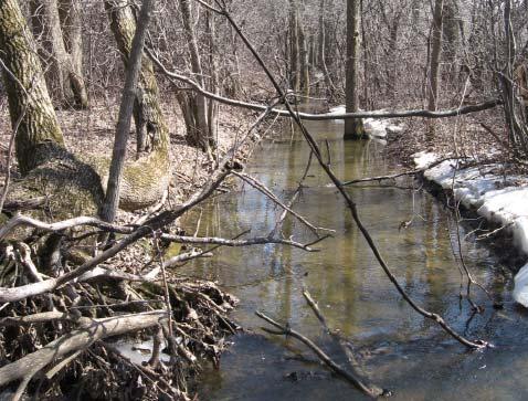
10 Site 1 Site 4, looking south Site 2 Site 3 Site 4, looking west March 19, 2009


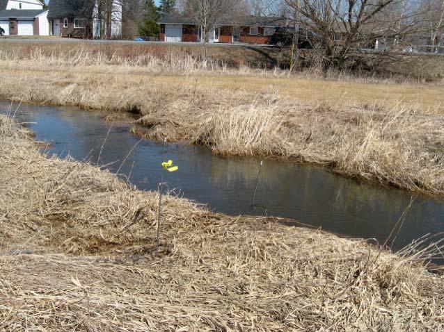
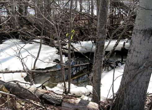
11 Site 1 Site 4, looking south Site 2 Site 5 Site 3 Site 6 March 27, 2009 Site 4, looking west


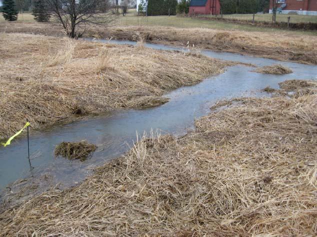
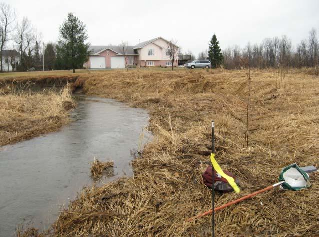
12 Site 1 Site 4, looking south Site 2 Site 5 Site 3 Site 6 April 3, 2009 Site 4, looking west


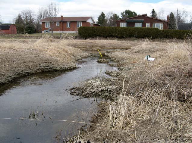
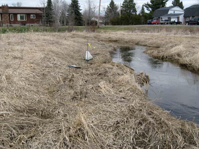
13 Site 1 Site 4, looking south Site 2 Site 5 Site 3 Site 6 April 10, 2009 Site 4, looking west


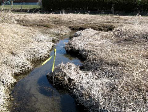
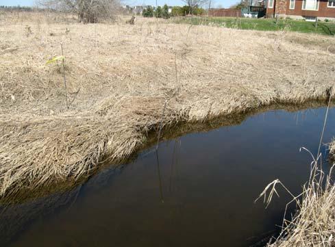
14 Site 1 Site 4, looking south Site 2 Site 5 Site 3 Site 6 Site 4, looking west April 19, 2009


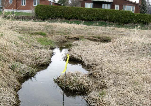
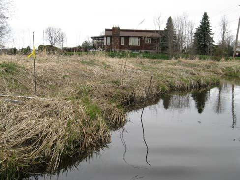
15 Site 1 Site 4, looking south Site 2 Site 5 Site 3 Site 6 April 26, 2009 Site 4, looking west
Minnesota Department of Natural Resources Division of Fish and Wildlife Section of Fisheries. Stream Survey Report. Cold Spring Creek.
 Minnesota F-29-R(P)-24 Area 315 Study 3 March 2015 Minnesota Department of Natural Resources Division of Fish and Wildlife Section of Fisheries Stream Survey Report Cold Spring Creek 2014 Mark Pelham Montrose
Report prepared for: Prepared by: January 2002 BEAK Ref
 AQUATIC ENVIRONMENTAL STUDY KANATA WEST CONCEPT PLAN Report prepared for: ROBINSON CONSULTANTS Prepared by: BEAK INTERNATIONAL INCORPORATED 14 Abacus Road Brampton, Ontario L6T 5B7 January 2002 BEAK Ref.
Minnesota Department of Natural Resources Division of Fish and Wildlife Section of Fisheries. Stream Survey Report. Cold Spring Creek.
 Minnesota F-29-R(P)-24 Area 315 Study 3 March 2013 Minnesota Department of Natural Resources Division of Fish and Wildlife Section of Fisheries Stream Survey Report Cold Spring Creek 2012 Mark Pelham Montrose
Firth Creek Habitat Enhancement Project 1993
 Firth Creek Habitat Enhancement Project 1993 A. R. Langston December 1993 PWFWCP Report No. 77 The Peace/Williston Fish & Wildlife Compensation Program is a cooperative venture of BC Hydro and the provincial
Minnesota Department of Natural Resources Division of Fish and Wildlife Section of Fisheries. Stream Survey Report. Three Mile Creek 2011
 Minnesota Department of Natural Resources Division of Fish and Wildlife Section of Fisheries Stream Survey Report Three Mile Creek 2011 By Joseph D. Stewig Montrose Area Fisheries Office TABLE OF CONTENTS
Alberta Conservation Association 2017/18 Project Summary Report
 Alberta Conservation Association 2017/18 Project Summary Report Project Name: Abundance, Distribution, Spawning, and Thermal Habitat of Westslope Cutthroat Trout and Bull Trout in the Stimson Creek Watershed
Eastern Brook Trout Joint Venture Annual Report The Nature Conservancy 2013
 Eastern Brook Trout Joint Venture Annual Report The Nature Conservancy 2013 2013 Annual Performance Report Enhancing Connectivity in the Ash-Black Rock Sub-basin of the West Branch Narraguagus River. Project
APPENDIX 3. Distribution Maps of Fish Species
 APPENDIX 3 Distribution Maps of Fish Species This appendix contains maps of known past and present fish distributions within the Manistique River watershed. The distributions of fish species were compiled
SUMMARY REPORT FOR LAKE ST. MALO FISHERIES ASSESSMENT. Prepared for the St. Malo and District Wildlife Association
 SUMMARY REPORT FOR LAKE ST. MALO FISHERIES ASSESSMENT Prepared for the St. Malo and District Wildlife Association Presented by August 25, 2014 Study dates thus far: Date Tasks February 16 Fishing derby;
Job 1. Title: Estimate abundance of juvenile trout and salmon.
 STUDY PERFORMANCE REPORT State: Michigan Project No.: F-53-R-13 Study No.: 461 Title: Population dynamics of juvenile rainbow trout and coho salmon in Lake Superior tributaries Period Covered: April 1,
Fish Passage Culvert Assessment for Cahilty Creek Watershed FIA Project #
 Fish Passage Culvert Assessment for Cahilty Creek Watershed FIA Project # 4602004 Prepared for Weyerhaeuser Company Ltd. Jason Ladyman R.P.F. 1550 Mission Flats Road PO Box 40 Kamloops BC V2C 5K3 Prepared
NORTH RIVER FISH KILL PRELIMINARY REPORT 2014 SUMMARY
 NORTH RIVER FISH KILL PRELIMINARY REPORT 2014 SUMMARY A fish kill on Nor River was reported to e 1-800 Environmental emergency number on August 9, 2014. Representatives from e PEI Department of Environment,
Fish Passage Culvert Inspection (FPCI) Nicklen Creek Watershed
 Nicklen Creek Watershed") Fish Passage Culvert Inspection (FPCI) Nicklen Creek Watershed FPCI Sites funded by FIA Prepared for: Tolko Industries Ltd., Okanagan Regional Woodlands & British Columbia Timber Sales, Okanagan-Shuswap
Fish Passage Culvert Inspection (FPCI) Nicklen Creek Watershed FPCI Sites funded by FIA Prepared for: Tolko Industries Ltd., Okanagan Regional Woodlands & British Columbia Timber Sales, Okanagan-Shuswap
7 8 Mahogany Creek views downstream and upstream along creek corridor from Manotick Main Street (1, 2), Bridgeport Avenue (3, 4) and Century Road
, Bridgeport Avenue (3, 4) and Century Road") Appendix B Photos 1 2 3 4 5 6 7 8 Mahogany Creek views downstream and upstream along creek corridor from Manotick Main Street (1, 2), Bridgeport Avenue (3, 4) and Century Road East (5, 6). Storm sewer
Appendix B Photos 1 2 3 4 5 6 7 8 Mahogany Creek views downstream and upstream along creek corridor from Manotick Main Street (1, 2), Bridgeport Avenue (3, 4) and Century Road East (5, 6). Storm sewer
THE PROPOSED NETWORK RAIL (ESSEX AND OTHERS LEVEL CROSSING REDUCTION) ORDER DEPARTMENT FOR TRANSPORT REFERENCE: TWA/17/APP/05
 ORDER DEPARTMENT FOR TRANSPORT REFERENCE: TWA/17/APP/05") OBJ/148/W 003 H05 PATTENS CROSSING THE PROPOSED NETWORK RAIL (ESSEX AND OTHERS LEVEL CROSSING REDUCTION) ORDER PUBLIC INQUIRY, 18 OCTOBER 2017 DEPARTMENT FOR TRANSPORT REFERENCE: TWA/17/APP/05 OBJECTION
OBJ/148/W 003 H05 PATTENS CROSSING THE PROPOSED NETWORK RAIL (ESSEX AND OTHERS LEVEL CROSSING REDUCTION) ORDER PUBLIC INQUIRY, 18 OCTOBER 2017 DEPARTMENT FOR TRANSPORT REFERENCE: TWA/17/APP/05 OBJECTION
DFO Request for Review - Miller Paving Limited, Carden Quarry, Nov. 16, 2015.
 DFO Request for Review - Miller Paving Limited, Carden Quarry, Nov. 16, 2015. Section D: Description of the Aquatic Environment Upstream of Site The northeast boundary of the property is along the Kirkfield
Alewife Brook, Cape Elizabeth, River Herring Monitoring Summary 2015
 University of Southern Maine USM Digital Commons Publications Casco Bay Estuary Partnership (CBEP) 2-3-2016 Alewife Brook, Cape Elizabeth, River Herring Monitoring Summary 2015 Matt Craig University of
Thunder Bay River Assessment Appendix. Appendix 2
 Appendix 2 Known past and present fish distributions in the River system. Distribution of fishes were compiled from Bailey et al. (2003) and from records located at the Michigan Department of Natural Resources
NEVADA DEPARTMENT OF WILDLIFE STATEWIDE FISHERIES MANAGEMENT
 NEVADA DEPARTMENT OF WILDLIFE STATEWIDE FISHERIES MANAGEMENT FEDERAL AID JOB PROGRESS REPORTS F-20-52 2016 Lake Tahoe Rainbow Trout Study WESTERN REGION NEVADA DEPARTMENT OF WILDLIFE, FISHERIES DIVISION
CLYDE RIVER FISH KILL 2016 PRELIMINARY REPORT
 CLYDE RIVER FISH KILL 2016 PRELIMINARY REPORT November 2016 CLYDE RIVER FISH KILL PRELIMINARY REPORT, NOVEMBER 2016 SUMMARY A fish kill on Clyde River was reported to e Prince Edward Island Department
Lower Dolores River Corridor Planning Meeting Jim White Colorado Division of Wildlife
 Lower Dolores River Corridor Planning Meeting Jim White Colorado Division of Wildlife Objectives Overview of cold and warm water fishes in the Dolores River including: Flow and Fish Management Distribution
Freshwater Fish Assessment
 Alaska Department of Transportation & Public Facilities Seward Highway MP 7-9 6-7 Freshwater Fish Assessment March 14, 8 Prepared by HDR Alaska C Street, Suite 3 Anchorage, Alaska 993 Project Number: BR-BH-NH-OA3
Review of Fish and Fish Habitat Information from the Bearberry Creek Drainage. Alberta Conservation Association Activity Report.
 Review of Fish and Fish Habitat Information from the Bearberry Creek Drainage. Alberta Conservation Kevin Fitzsimmons 1 2005 1 Alberta Conservation Association, Box 1420, Cochrane, Alberta, Canada, T4C
Trip Report: Eagle Creek, Arizona
 Trip Report: Eagle Creek, Arizona 15-17 June 2009 Participants: Abraham Karam, Brian Kesner, and Mike Childs Native Fish Lab Marsh & Associates, LLC 5016 South Ash Avenue Suite 108 Tempe, Arizona 85282
The Fish Fauna of Cranberry Bog, Town of Burlington, Otsego County, N.Y.
 80 The Fish Fauna of Cranberry Bog, Town of Burlington, Otsego County, N.Y. Steven M. Foster* ABSTRACT In June 1995 a baseline fish survey of Cranberry Bog was conducted in order to identify the species
STREAM CLASSIFICATION AND MAPPING. Prepared For. MacMillan Bloedel Ltd. Menzies Bay Division BOX 6000, Campbell River V9W 5E1.
 STREAM CLASSIFICATION AND MAPPING OF STREAMS IN MENZIES AND OYSTER BAY Prepared For MacMillan Bloedel Ltd. Menzies Bay Division BOX 6000, Campbell River V9W 5E1 September 1998 a a North Island Biological
Fish population survey report
 Fish population survey report River Teme 2016 This report provides a summary of results from recent coarse fish population surveys on the River Teme between Tenbury Wells and Powick. The surveys were carried
Interim Guidance Fish Presence Absence
 Interim Guidance Fish Presence Absence Source: Forest Practices Act Guidance for Division 635 of the forest practices act dealing with stream classification when no fish surveys have been done (referenced
MINNESOTA FRESHWATER MUSSEL SURVEY AND RELOCATION PROTOCOL
 MINNESOTA FRESHWATER MUSSEL SURVEY AND RELOCATION PROTOCOL Minnesota Department of Natural Resources, Division of Ecological and Water Resources U.S. Fish and Wildlife Service, Twin Cities Field Office
REMIBAR REMIBAR. Evaluation of mitigation measures for otter in the Remibar project. EC LIFE+ programme LIFE10 NAT/SE/045
 REMIBAR REMIBAR Evaluation of mitigation measures for otter in the Remibar project EC LIFE+ programme LIFE10 NAT/SE/045 1 Author: Niklas Kemi and Torbjörn Nilsson, Trafikverket and Åsa Kestrup, The County
Tahquamenon River Assessment Appendix
 DNR DEPARTMENT OF NATURAL RESOURCES MICHIGAN STATE OF MICHIGAN DEPARTMENT OF NATURAL RESOURCES SR45 Appendix February 2008 Tahquamenon River Assessment Appendix James R. Waybrant and Troy G. Zorn www.michigan.gov/dnr/
STEELHEAD SURVEYS IN OMAK CREEK
 STEELHEAD SURVEYS IN OMAK CREEK 2002 Annual Report Prepared by Chris Fisher John Arterburn Colville Confederated Tribes Fish and Wildlife Department P.O. Box 150 Nespelem, WA 99155 Prepared for Project
COA-F17-F-1343 YEAR END REPORT
 DAVE MARSHALL SALMON RESERVE RESTORATION, MAINTENANCE, AND UPGRADES YEAR END REPORT Prepared for: Fish and Wildlife Compensation Program Prepared by: Edith Tobe, RPBio, Executive Director Box 1791, Squamish,
Jason Blackburn, Paul Hvenegaard, Dave Jackson, Tyler Johns, Chad Judd, Scott Seward and Juanna Thompson
 Alberta Conservation Association (ACA) Date: 2014-2015 Project Name: Owl River Walleye and Aquatic Habitat Assessment Fisheries Program Manager: Peter Aku Project Leader: Tyler Johns Primary ACA staff
Minnesota Department of Natural Resources Division of Fish and Wildlife Section of Fisheries. Stream Survey Report. Luxemburg Creek.
 Minnesota F-29-R(P)-24 Area 315 Study 3 March 2016 Minnesota Department of Natural Resources Division of Fish and Wildlife Section of Fisheries Stream Survey Report Luxemburg Creek 2015 Mark Pelham Sauk
Proposed Reclassification of Cherry Creek, North Platte River Basin, Wyoming. October 25, 2010
 Proposed Reclassification of Cherry Creek, North Platte River Basin, Wyoming October 25, 2010 Waterbody: Location: Tributary to: Cherry Creek - Mainstem from headwaters downstream to the confluence with
STUDY PERFORMANCE REPORT
 STUDY PERFORMANCE REPORT State: Michigan Project No.: F-80-R-4 Study No.: 702 Title: Effects of sediment traps on Michigan river channels Period Covered: October 1, 2002 to September 30, 2003 Study Objectives:
ATTACHMENT F. Minnesota Department of Natural Resources. Marsh Lake Ecosystem Restoration Project
 ATTACHMENT F Minnesota Department of Natural Resources Marsh Lake Ecosystem Restoration Project Mussel Rescue and Translocation Plan for Pomme de Terre River Restoration (Prepared June, 2016) Attachment
ELECTRO-FISHING REPORT 2016 UPPER TWEED
 ELECTRO-FISHING REPORT 2016 UPPER TWEED The electro-fishing programme carried out each summer by The Tweed Foundation is part of our management plan, which details the information that is required to manage
Fish population survey report
 Fish population survey report Upper River Avon Catchment This report provides a summary of results from recent fish population surveys on the Tetbury Avon, Sherston Avon and River Marden The surveys were
Blue Creek Chinook Outmigration Monitoring Technical Memorandum
 Blue Creek Chinook Outmigration Monitoring 2012 Technical Memorandum Prepared by: Andrew Antonetti and Erika Partee Yurok Tribe Fisheries Program PO Box 1027 Klamath, California 95548 In Partnership with:
Bonita Creek Fish Monitoring September 29 October 2, 2015
 Bonita Creek Fish Monitoring September 29 October 2, 2015 Brittany M. Woodward, Kristen G. Humphrey, and Brian R. Kesner Marsh & Associates, LLC 5016 S. Ash Avenue, Suite 108 Tempe, Arizona 85282 Submitted
SUMMARY OF MOVEMENT AND HABITAT USED BY TAGGED BROOK TROUT IN THE MAIN BRANCH AND NORTH BRANCH AU SABLE RIVER DURING SUMMER Data Submitted to:
 SUMMARY OF MOVEMENT AND HABITAT USED BY TAGGED BROOK TROUT IN THE MAIN BRANCH AND NORTH BRANCH AU SABLE RIVER DURING SUMMER 2014 Data Submitted to: Anglers of the Au Sable Submitted by: Dr. Mark R. Luttenton
Fossil Creek Native Fish Repatriation 2009 Implementation Plan Arizona Game and Fish Department
 Fossil Creek Native Fish Repatriation 2009 Implementation Plan Arizona Game and Fish Department MONITORING: Annual monitoring is conducted for each species stocked, typically during late summer or early
FINAL REPORT. Yonkers Creek Migration Barrier Removal Project Wonderstump Road Del Norte County. Submitted By:
 FINAL REPORT Yonkers Creek Migration Barrier Removal Project Wonderstump Road Del Norte County Submitted By: Del Norte County Community Development Department Yonkers Creek Migration Barrier Removal Project
Alberta Conservation Association 2018/19 Project Summary Report
 Alberta Conservation Association 2018/19 Project Summary Report Project Name: Ram River Bull Trout Assessment Fisheries Program Manager: Peter Aku Project Leader: Chad Judd Primary ACA staff on project:
Chinook Salmon Spawning Study Russian River Fall 2005
 Chinook Salmon Spawning Study Russian River Fall 2005 Sonoma County Water Agency 2150 West College Avenue Santa Rosa, California 95401 Prepared by David Cook - Senior Environmental Specialist March 27,
Geography of the Lower Fitzroy and navigation problems
 Geography of the Lower Fitzroy and navigation problems A topographic map of the Fitzroy estuary readily indicates why the Fitzroy River has proved difficult for shipping to negotiate. The river meanders
Discussion on the Selection of the Recommended Fish Passage Design Discharge
 Discussion on the Selection of the Recommended Fish Passage Design Discharge Introduction The provision of fish passage is a requirement for most proposed culvert and bridge installations in Alberta, depending
Identifying Areas with Potential to Contain High Value Fish Habitat (HVFH) June 2007
 June 2007") Identifying Areas with Potential to Contain High Value Fish Habitat (HVFH) June 2007 1 High Value Fish Habitat INTENT: To apply added precautionary protection to those special areas deemed of high value
Identifying Areas with Potential to Contain High Value Fish Habitat (HVFH) June 2007 1 High Value Fish Habitat INTENT: To apply added precautionary protection to those special areas deemed of high value
Chadbourne Dam Repair and Fish Barrier
 Chadbourne Dam Repair and Fish Barrier Final Report for the Western Native Trout Initiative Prepared by: Carol Endicott Yellowstone Cutthroat Trout Conservation Biologist Montana Fish, Wildlife & Parks
SURVEY METHODOLOGY. April 15, Rob Livick City of Morro Bay Public Services Director/City Engineer 955 Shasta Avenue San Luis Obispo, CA 93401
 April 15, 2011 Rob Livick City of Morro Bay Public Services Director/City Engineer 955 Shasta Avenue San Luis Obispo, CA 93401 SUBJECT: Summary Letter Report for Tidewater Goby and Steelhead Monitoring
Ontario Ministry of Transportation (MTO) Restoring Fish Passage to a Tributary of the Saugeen River
 Restoring Fish Passage to a Tributary of the Saugeen River") Ontario Ministry of Transportation (MTO) Restoring Fish Passage to a Tributary of the Saugeen River 2017 Transportation Association of Canada Environmental Achievement Award Nomination Submission Prepared
Ontario Ministry of Transportation (MTO) Restoring Fish Passage to a Tributary of the Saugeen River 2017 Transportation Association of Canada Environmental Achievement Award Nomination Submission Prepared
Flint River Assessment Appendix
 14 Appendix 3 Distribution Maps of Fish Species This appendix contains maps of past and known present fish distributions within the River watershed. The distributions of fish species were compiled from
Regulatory Guidelines for Managing the Muskellunge Sport Fishery in Ontario
 Regulatory Guidelines for Managing the Muskellunge Sport Fishery in Ontario Fisheries Section Fish and Wildlife Branch Ontario Ministry of Natural Resources June 2003 Updated August 2005 Regulatory Guidelines
Final Bull Trout Redd Monitoring Report for the Wallowa Falls Hydroelectric Project
 Final for the Wallowa Falls Hydroelectric Project East Fork Wallowa River barrier to upstream fish migration, photo courtesy of Kendrick Moholt (FERC No. P-308) December 18, 2017 Prepared by: Jeremiah
Nechako white sturgeon are an Endangered Species
 Nechako white sturgeon are an Endangered Species There are likely less than 350 Nechako white sturgeon, and historically there were over 5000 in the Nechako Watershed. Endangered as per the Species at
Lake Superior. Ontonagon River Assessment. Ontonagon. Rockland. Victoria Dam. Bergland. Bergland. Dam. Bruce Crossing Agate Falls. Kenton Lower.
 Sand shiner otropis stramineus feeding - sand and gravel substrate - shallow pools in medium size streams, lakes, and impoundments - clear water and low gradient - rooted aquatic vegetation preferred -
COLORADO RIVER RECOVERY PROGRAM RECOVERY PROGRAM FY 2015 ANNUAL PROJECT REPORT PROJECT NUMBER: 160
 COLORADO RIVER RECOVERY PROGRAM RECOVERY PROGRAM FY 215 ANNUAL PROJECT REPORT PROJECT NUMBER: 16 I. Project Title: Assessment of Stocked Razorback Sucker Reproduction in the Lower Green and Lower Colorado
STREAM SURVEY File form No..
 scanned for KRIS THE RESOURCES AGENCY OF CALIFORNIA California Department of Fish and Game STREAM SURVEY File form No.. Date: September 4, 1969. NAME: North Fork Schooner Gulch Creek COUNTY: Mendocino.
Fisheries Review with Respect to Stormwater Management for Milton/Navan Road Property
 Fax: 613.935.6295 Mr. Jean-Luc Rivard 3223701 CANADA INC. 98 rue Lois Gatineau, QC J8Y 3R7 July 23, 2014 Re.: Fisheries Review with Respect to Stormwater Management for Milton/Navan Road Property Mr. Rivard:
Lye Brook Amphibian Monitoring. Update. For the Vermont Monitoring Cooperative
 Lye Brook Amphibian Monitoring Update 2010 (Covering 1995-2009) For the Vermont Monitoring Cooperative Erin Talmage and James S. Andrews Amphibian Monitoring in the Lye Brook Wilderness Region of the Green
FISH PASSAGE ALTERNATIVES ANALYSIS ON PENNYPACK CREEK AT VERREE ROAD DAM AND ROOSEVELT BOULEVARD DAM PHILADELPHIA, PENNSYLVANIA
 FISH PASSAGE ALTERNATIVES ANALYSIS ON PENNYPACK CREEK AT VERREE ROAD DAM AND ROOSEVELT BOULEVARD DAM PHILADELPHIA, PENNSYLVANIA Prepared for: One Parkway, 10 th Floor 1515 Arch Street Philadelphia, PA
Abundance of Steelhead and Coho Salmon in the Lagunitas Creek Drainage, Marin County, California
 scanned for KRIS Abundance of Steelhead and Coho Salmon in the Lagunitas Creek Drainage, Marin County, California Prepared for: Marin Municipal Water District 220 Nellen Drive Corte Madera, California
Bonita Creek Fish Monitoring November 4 6, 2015
 Bonita Creek Fish Monitoring November 4 6, 2015 Brittany M. Woodward, Kristen G. Humphrey, and Brian R. Kesner Marsh & Associates, LLC 5016 S. Ash Avenue, Suite 108 Tempe, Arizona 85282 Submitted to Bureau
Climate Change Adaptation and Stream Restoration. Jack Williams;
 Climate Change Adaptation and Stream Restoration Jack Williams; jwilliams@tu.org 1 Goals for this presentation Develop strategies for adapting streams to climate impacts by Thinking like a watershed Understanding
STUDY PERFORMANCE REPORT
 STUDY PERFORMANCE REPORT State: Michigan Project No.: F-81-R-3 Study No.: 491 Title: Evaluation of lake sturgeon Acipenser fulvescens populations in the St. Clair River and Lake St. Clair Period Covered:
1 INTRODUCTION AND SUMMARY
 December 10, 2012 Pacific Booker Minerals 1702 1166 Alberni Street Vancouver, British Columbia V6E 3Z3 Erik Tornquist Executive VP and COO Dear Mr. Erik Tornquist: 1 INTRODUCTION AND SUMMARY This letter
STUDY PERFORMANCE REPORT
 STUDY PERFORMANCE REPORT State: Michigan Project No.: F-35-R-24 Study No.: 682 Title: Pond rearing of juvenile lake sturgeon Period Covered: April 1, 1998 to September 30, 1999 Study Objective: To determine
Great Lakes Coastal Wetland Communities: Vulnerabilities to Climate Change and Response to Adaptation Strategies
 Great Lakes Coastal Wetland Communities: Vulnerabilities to Climate Change and Response to Adaptation Strategies CCAF Wetlands Study Investigators: Susan Doka Fisheries & Oceans, Great Lakes Lab for Fisheries
Fish population survey report
 Fish population survey report River Lugg This report provides a summary of results from recent fish population surveys on the River Lugg between Leominster and Hereford. The surveys were carried out to
Project Completion Abstract Fish Passage Activity ( Engineering Activities)
") Project Completion Abstract Fish Passage Activity ( Engineering Activities) SUBMIT COMPLETED FORM TO DISTRICT MANAGER AND FIA ADMINISTRATOR AFTER PROJECT COMPLETION SECTION A GENERAL INFORMATION Recipient:
Project Completion Abstract Fish Passage Activity ( Engineering Activities) SUBMIT COMPLETED FORM TO DISTRICT MANAGER AND FIA ADMINISTRATOR AFTER PROJECT COMPLETION SECTION A GENERAL INFORMATION Recipient:
Juvenile Salmon Use of Knik Arm Estuaries. Hannah N. Ramage
 Juvenile Salmon Use of Knik Arm Estuaries Hannah N. Ramage Literature Review Function of estuaries for juvenile salmon Migration pathway Pink salmon use estuaries as a neutral pathway (Simenstad 1982)
Go Home Bay Walleye Re-introduction Project
 Eastern Georgian Bay Stewardship Council www.helpourfisheries.com Go Home Bay Walleye Re-introduction Project Eastern Georgian Bay Stewardship Council July 27, 2010 Walleye summer fingerlings planted in
Native Suckers of the Chuska Mountains and Defiance Plateau GLENN SELBY-FISH BIOLOGIST
 Native Suckers of the Chuska Mountains and Defiance Plateau GLENN SELBY-FISH BIOLOGIST Native Species on the Chuska Mts and Defiance Plateau Speckled Dace Bluehead sucker Zuni bluehead sucker Native Suckers
Finescale Dace. Appendix A: Fish. Chrosomus neogaeus. New Hampshire Wildlife Action Plan Appendix A Fish-60
 Finescale Dace Chrosomus neogaeus Federal Listing State Listing Global Rank State Rank Regional Status SC S3 Photo by John Lyons Justification (Reason for Concern in NH) Finescale dace are vulnerable to
NEVADA DEPARTMENT OF WILDLIFE STATEWIDE FISHERIES MANAGEMENT
 NEVADA DEPARTMENT OF WILDLIFE STATEWIDE FISHERIES MANAGEMENT FEDERAL AID JOB PROGRESS REPORTS F-20-52 2016 REDBAND TROUT EASTERN REGION NEVADA DEPARTMENT OF WILDLIFE, FISHERIES DIVISION ANNUAL JOB PROGRESS
Judd Lake Adult Sockeye Salmon Data Report 2012
 Judd Lake Adult Sockeye Salmon Data Report 2012 Prepared by: Nathan Weber, Biologist July 2013 The Judd Lake Project was made possible through a State of Alaska Designated Legislative Grant. This page
2012 Susitna River Water Temperature and Meteorological Field Study
 (FERC No. 14241) 2012 Susitna River Water Temperature and Meteorological Field Study Appendix A Prepared for Prepared by URS Corporation Tetra Tech Inc. February 2013 APPENDIX A: PHOTOGRAPHS AND SITE INFORMATION
Proposed Reclassification of Deer Creek, North Platte River Basin, Wyoming
 Proposed Reclassification of Deer Creek, North Platte River Basin, Wyoming October 25, 2010 Waterbody: Location: Tributary to: Deer Creek - Mainstem from headwaters downstream to the confluence with the
Tahquamenon River Assessment
 State owned land USFS land Superior Lower Falls USGS Gauging Station Superior Tahquamenon s Belle s Slater s Bass Betty B Dollarville Flooding Eckerman McMillan Mud East Kaks Twin McPhee s Hulbert Hulbert
Fish Community. Fish Habitat, Streams and Rivers
 Clear, Ston(e)y and White Lake Plan Fish Community The lakes support a cool/warm water fishery including muskellunge, walleye, largemouth and smallmouth bass, yellow perch, pumpkinseed, rockbass, blue
Final Fish Salvage & Temporary Tailrace Barrier Report for the Wallowa Falls Hydroelectric Project Tailrace. (FERC No. P-308) December 18, 2017
 December 18, 2017") Final for the Wallowa Falls Hydroelectric Project Tailrace (FERC No. P-308) December 18, 2017 Prepared by: Jeremiah Doyle PacifiCorp 825 NE Multnomah Street Portland, OR 97232 December 18, 2017 Page 1
Final for the Wallowa Falls Hydroelectric Project Tailrace (FERC No. P-308) December 18, 2017 Prepared by: Jeremiah Doyle PacifiCorp 825 NE Multnomah Street Portland, OR 97232 December 18, 2017 Page 1
2013 Fish and Fish Habitat Survey Results
 Prepared for HUSKY OIL OPERATIONS LIMITED 707 8 th Avenue SW Box 6525, Station D Calgary, Alberta T2P 3G7 2013 Fish and Fish Habitat Survey Results Slater River Project EL494 Tulita District, Sahtu Region,
Holderness. The Three Watersheds within the Newfound Lake Drainage Dorchester. Groton Plymouth. Ashland. Hebron. Canaan. Bridgewater.
 Background Brook trout are the only native stream dwelling trout species in New Hampshire, having a historic range that extended from Georgia to eastern Canada. It is believed that wild brook trout were
APPENDIX A PHOTOGRAPHIC SUMMARY. RAINY RIVER PROJECT Final Environmental Assessment Report
 APPENDIX A PHOTOGRAPHIC SUMMARY RAINY RIVER PROJECT APPENDIX A: PHOTOGRAPHIC SUMMARY LIST OF PHOTOGRAPHS PAGE Plate 1: (RRP) core processing facility... 1 Plate 2: Typical exploration drilling operations...
Thanks to Burt Strom, Dick Pearce, and Ed Lombardo, Sr. for their help and information.
 The upper section of the Wood River that runs approximately two miles downstream from the bridge on State Route 165 contains a number of significant pools. Although the river is constantly changing through
Final Fish Salvage & Temporary Tailrace Barrier Report for the Wallowa Falls Hydroelectric Project Tailrace. (FERC No. P-308) December 20, 2018
 December 20, 2018") Final Fish Salvage & Temporary Tailrace Barrier Report for the Wallowa Falls Hydroelectric Project Tailrace (FERC No. P-308) December 20, 2018 Prepared by: Jeremiah Doyle PacifiCorp 825 NE Multnomah Street
Final Fish Salvage & Temporary Tailrace Barrier Report for the Wallowa Falls Hydroelectric Project Tailrace (FERC No. P-308) December 20, 2018 Prepared by: Jeremiah Doyle PacifiCorp 825 NE Multnomah Street
Sports Fish Spawning Surveys Results of sports fish spawning surveys, June 2016-June 2017 in the West Coast Fish & Game Region
 Sports Fish Spawning Surveys 2016-2017 Results of sports fish spawning surveys, June 2016-June 2017 in the West Coast Fish & Game Region Lee Crosswell, Fish & Game Officer, July 2017 Rainbow Trout, Geologist
Total Suspended Solids, Stable Flow, and Wet Weather Event Monitoring in the Bass River Watershed. December The Cadmus Group, Inc.
 Total Suspended Solids, Stable Flow, and Wet Weather Event Monitoring in the Bass River Watershed December 2004 The Cadmus Group, Inc. Grand Valley State University Annis Water Resources Institute Submitted
Executive Summary Mount Milligan 2004
 Executive Mount Milligan 2004 Mt. Milligan Lake is a shallow and productive, 24 ha, marl bottomed lake situated 110 km southwest of Mackenzie. A stocking assessment was conducted at Mt. Milligan Lake between
Redd Dewatering and Juvenile Salmonid Stranding in the Lower Feather River,
 Redd Dewatering and Juvenile Salmonid Stranding in the Lower Feather River, 2005-2006 Interim Report for NOAA Fisheries Prepared by: California Department of Water Resources Division of Environmental Services
Assessment of Baseline Geomorphic Features at. Proposed Stream Crossings On The Proposed County Road 595. Marquette County, Michigan
 Assessment of Baseline Geomorphic Features at Proposed Stream Crossings On The Proposed County Road 595 Marquette County, Michigan Prepared for: Kennecott Eagle Minerals Company Marquette, Michigan Prepared
Understanding the Impacts of Culvert Performance on Stream Health
 Understanding the Impacts of Culvert Performance on Stream Health Kristin Thomas Aquatic Ecologist Michigan Trout Unlimited Transportation and the Environment Conference 12/5/2018 Importance of adequately
Fish Survey of Arctic Lake (ID # ), Scott County, Minnesota in 2012
, Scott County, Minnesota in 2012") Snapping Turtle from Arctic Lake, September 2012 Fish Survey of Arctic Lake (ID #70-0085), Scott County, Minnesota in 2012 Survey Dates: September 18-20, 2012 MnDNR Permit Number: 18362 Prepared for: Shakopee
Snapping Turtle from Arctic Lake, September 2012 Fish Survey of Arctic Lake (ID #70-0085), Scott County, Minnesota in 2012 Survey Dates: September 18-20, 2012 MnDNR Permit Number: 18362 Prepared for: Shakopee
SITE SPECIFIC GUIDELINES FOR OPERATIONS DURING PACIFIC HERRING SPAWN WINDOWS
 SITE SPECIFIC GUIDELINES FOR OPERATIONS DURING PACIFIC HERRING SPAWN WINDOWS Prepared by: Introduction The Fisheries Act prohibits activities which cause the harmful alteration, disruption or destruction
FISH PASSAGE IMPROVEMENT in California s Watersheds. Assessments & Recommendations by the Fish Passage Forum
 FISH PASSAGE IMPROVEMENT in California s Watersheds Assessments & Recommendations by the Fish Passage Forum FISH PASSAGE IMPROVEMENT in California s Watersheds The mission of the Fish Passage Forum is
Alberta Conservation Association 2018/19 Project Summary Report. Project Name: North Saskatchewan River Drainage Fish Sustainability Index Data Gaps
 Alberta Conservation Association 2018/19 Project Summary Report Project Name: North Saskatchewan River Drainage Fish Sustainability Index Data Gaps Fisheries Program Manager: Peter Aku Project Leader:
Creation of Fish and Wildlife Habitat on the Closed Salmon Harbour Mine in Minto, NB
 Creation of Fish and Wildlife Habitat on the Closed Salmon Harbour Mine in Minto, NB M. Coleman 1, R. Rutherford 2, RA Currie 3 1 NB Power 2 Thaumas Environmental Consultants Ltd 3 RA Currie Ltd. Location
WFC 10 Wildlife Ecology & Conservation Nov. 29, Restoration Ecology: Rivers & Streams. Lisa Thompson. UC Cooperative Extension
 Restoration Ecology: Rivers and Streams WFC 10 29 Nov 2010 Restoration of ecosystems often involves creating new systems with only partial resemblance to the original ecosystems Lisa Thompson Fisheries