Evaluation of Newbury Weirs (Rock Riffles) for Improving Habitat Quality and Biotic Diversity in Illinois Streams.
|
|
|
- Martin Stanley
- 5 years ago
- Views:
Transcription
1 Evaluation of Newbury Weirs (Rock Riffles) for Improving Habitat Quality and Biotic Diversity in Illinois Streams. Report submitted to The Wildlife Preservation Fund Illinois Department of Natural Resources By Hope R. Dodd* and David H. Wahl Center for Aquatic Ecology and Conservation Illinois Natural History Survey April 2007 *Present address: National Park Service, Missouri State University, Biology Department, 901 S National Avenue, Springfield, MO page 1
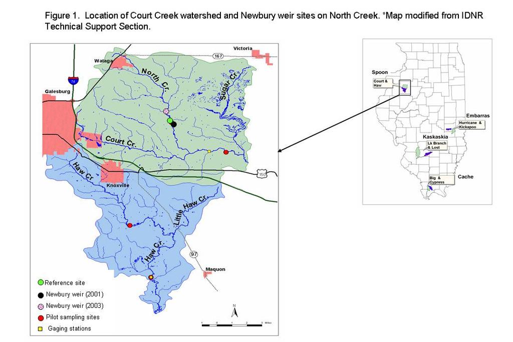
2 Introduction In predominately agricultural watersheds, such as those in Illinois, remediation techniques have been used for reducing nonpoint source pollution (see Gale et al. 1993). In 1998, the Illinois Natural History Survey in conjunction with the Illinois Department of Natural Resources (IDNR) began collecting baseline data on four Illinois watersheds that were targeted for extensive remediation practices. One watershed in the Spoon River basin has completed the implementation phase. As part of our study on the effects of watershed-wide remediation, we also began assessing the effects of two sets of Newbury weirs (rock riffle structures installed in summer 2001 and a second set in spring 2003) on abiotic and biotic parameters of stream quality. From a scientific and management perspective, there is still a great deal to be learned about the relative effectiveness of individual practices in particular environmental settings and how fish and invertebrate assemblages respond to these practices under various environmental conditions. By assessing individual practices, we can inform watershed planning committees which types of practices will have the greatest impact on stream quality, thus, aiding their decisions in watershed remediation planning. The goal of this study was to increase our understanding of riffle structures for improving stream quality in Illinois watersheds. Our specific objectives were to assess changes in physical habitat due to installation of Newbury weirs and assess the response of macroinvertebrate and fish assemblages to this particular type of remediation practice. Study Site and Methods For our study on rock riffle structures, sites were located in the Court Creek Watershed, a tributary to the Spoon River basin (Figure 1). In 2001 and 2003, Newbury weirs (rock riffle structures) were installed in two separate stream reaches on North Creek (tributary to Court Creek), Knox County, IL. We monitored these two weir sites and a reference site before and after weir installation. At the site where Newbury weirs were installed in 2001 (NW1), we monitored habitat, fish, and invertebrates twice before (fall 2000 and spring 2001) and seven times after (late summer and spring ) weir placement. At the second set of weirs installed in 2003 (NW2), we collected habitat, fish, and invertebrate data twice before (fall 2002 and spring 2003) and four times after (late summer and spring and spring 2006) weir implementation. The control or reference site on North Creek was also sampled at approximately the same time as the two treated sites. Length of both treated and reference sites were approximately 20 times mean bankfull width (Gough 1997) to ensure that at least one riffle-run-pool sequence was sampled. At all three sites, physical habitat and bank/riparian cover was measured using a quantitative point/transect method (Stanfield et al.1998). Fish were collected using IDNR s standard protocol of a single pass with an AC electric seine using block nets to enclose the stream reach (Bayley et al. 1989). Macroinvertebrates were quantitatively sampled using a stratified random sampling design whereby habitats were sampled in proportion to their availability. We used a coring device in pool areas and a Hess sampler in riffles. At both weir sites, changes in abiotic and biotic parameters were assessed by comparing these characteristics of stream quality before and after implementation. Analysis of Variance was used to determine significant differences in habitat and biota between before and after time periods. An alpha value of 0.05 was used to determine significant changes in habitat and biotic communities. page 2
3 Results We found significant changes in habitat and biotic communities at these Newbury weir sites on North Creek. Several habitat variables showed a significant change between pre- and post-weir periods; however, the biotic community showed less of a change after implementation. Newbury Weir Site 1 At the first set of weirs installed in 2001 (NW1 site), we found that both point substrate and maximum substrate sizes significantly increased after weir installation due to placement of large rock in the stream to simulate natural riffles (p point sub. = 0.04, p max sub. = 0.02, Table 1). Although depth did not significantly increase in the post-weir period, we found that width and width/depth ratio was marginally significantly different (p < 0.10, Table 1) with average width increasing and width/depth ratio decreasing after weir installation. Average surface area sampled increased significantly (p = 0.04) following weir construction, possibly due to readjustment and shifting of the stream bed and banks, creating a wider channel. Overall, in-stream fish cover increased after implementation as indicated by the percentage of no fish cover decreasing after implementation (p no cover <0.001, Table 2). We did find that the percent of unembedded wood cover decreased (p <0.001); however, the percentage of embedded flat rock increased (p = 0.044). Percent habitat composition and in-stream vegetation changed more with season than between time periods (Tables 1 and 2). In late summer/early fall, habitat consisted primarily of pools with smaller amounts of run and slow riffle habitat. On the dates sampled in late spring, habitat composition was more diverse with larger percent run, slow riffle, and fast riffle habitat. Conversely, the amount of in-stream vegetation showed an opposite trend with higher percentage and more diverse types of vegetation in late summer/early fall than in late spring samples with the exception of the spring 2004 date. These trends in habitat composition and vegetation are probably due to higher water levels in the spring creating riffle and run habitat and preventing in-stream vegetation from becoming established; while, in the late summer, water levels are lower creating more slow flowing pooled areas and allowing vegetation to grow in the stream. As a result of these seasonal trends, we found no significant differences in habitat composition and only a marginally significant difference (p <0.10, Table 2) in filamentous algae between pre- and post-weir dates. Fish species richness and catch per unit effort (CPUE) did not significantly change after weir installation (Table 3). However, we observed a dramatic decline in CPUE a year following weir placement followed by a steady increase through time to numbers more similar to pre-weir conditions. We also found a shift in community composition after the weirs were installed. Percent composition of catostomids and centrarchids were marginally significantly higher after weir placement (p catostomids = 0.07, p centrarchids = 0.08), and percentage of smallmouth bass increased immediately after weir placement followed by a decline to pre-weir conditions four years after implementation. Since installation of these weirs, three new ictalurid species have been found at NW1 (black bullhead, channel catfish, and stonecat). This increase in catostomids and centrarchids and the appearance of black bullhead and channel catfish is potentially due to the creation of deeper scour pools located downstream of the riffle structures. page 3
4 At the first set of weirs, invertebrate taxa richness within riffles significantly increased after weir placement (p riffle richness = 0.04, Table 4). Although no other invertebrate parameters we analyzed changed significantly between the two time periods, we did observe a few shifts in community composition. Total taxa richness and the more sensitive insect taxa in the Ephemeroptera, Plecoptera, and Trichoptea (%EPT) families also increased after implementation. Relative abundance (catch per area, CPA) did not show a significant change after weir placement, but CPA in glide habitats did show a seasonal trend with higher numbers in the fall with the exception of the spring 2004 sampling date (Table 4). Newbury Weir Site 2 At the second set of weirs installed in 2003 (NW2), we found evidence that the structures affected physical habitat and the biota. However, fewer parameters significantly changed as a result of implementation compared to the changes at the NW1 site. After weir placement, the width/depth ratio significantly decreased (p = 0.002) due to the marginally significant increase in depth (p = 0.07, Table 5). Unlike the NW1 site, substrate did not significantly change, but average maximum substrate was marginally significantly larger after implementation (p = 0.08). As with the NW1 site, we observed an increase in amount of fish cover at the NW2 site following weir placement as evidenced by the marginally significant decline in amount of streambed with no cover (p = 0.07, Table 6). A seasonal trend in habitat composition and in-stream vegetation was also apparent at this weir site (Tables 5 and 6). Percentage of riffle and run habitats were greater in spring when flows are presumably higher due to spring rains. Late summer/fall sample dates tended to have higher percent of vegetation when flows are low and stable, allowing them to establish in the stream. Although percent vegetation showed a seasonal trend, we did find a significant decrease in filamentous algae after weir implementation (p = 0.003, Table6). We found no significant changes in our fish assemblage parameters after weir installment at the NW2 site and observed no dramatic decline in CPUE as we did at the NW1 site (Table 7). However, we did find similar shifts in assemblage composition as seen at the NW1 site. We found a marginally significant increase in percent centrarchids (p = 0.08) and percent smallmouth bass (p = 0.09) in the post-weir sample dates. We also found an increase in average number of darters which was not observed at the NW1 site. Invertebrate taxa richness within glide habitats significantly decreased after implementation (p glide richness = 0.03, Table 8), unlike at the NW1 site which showed an increase in richness in riffle habitats. No other invertebrate parameters significantly changed between the pre- and post-weir periods, but we did detect shifts in the community that oppose those shifts seen at the NW1 site. We observed %EPT decreased on average after implementation as opposed to NW1 where %EPT increased (Table 4). We also found a marginally significant increase in the Family Biotic Index (FBI) during the post-weir period (p = 0.08). Based on tolerance of the invertebrates present at NW2 site, water quality changed from fairly poor (average FBI = 6.1) in the pre-weir period to poor (7.0) in the post-weir period. This decrease in the sensitive EPT taxa and increase in FBI score suggests that some change in physical or chemical habitat quality may be impacting the invertebrate community at this site. page 4
5 Discussion and Summary Results from monitoring of Newbury weirs supports the idea that these structures change channel morphology characteristics of the stream. We found similar changes in channel morphology at both sites; implementation of rock riffle structures increased the amount of larger, stable substrate, created wider and deeper pool areas, and increased fish cover. In addition to changes in habitat, we found some similarities in the shifts and trends of fish community composition following weir placement. Percentage of centrachid species (which typically prefer pools with moderate to slow flows) increased following implementation, indicating that these structures do create new habitats important for several fish species. Comparing the two weir sites, we did find differences in their effects on stream fish and invertebrates when these structures are located at different drainage areas. At the NW1 site (located at a larger drainage area), shifts in fish assemblages included increased abundance of ictalurids and three new ictalurid species. Two of these new ictalurid species are larger bodied species (channel catfish and black bullhead) and typically prefer deeper pools. At the NW2 site, the number of darters (which are smaller species that typically prefer faster riffles) increased after weir placement. The difference in how the fish communities reacted to the weir implementation at the two sites is likely due to the downstream site (NW1) being closer in proximity to larger water (Court Creek) and, therefore, allowing colonization by bigger species in the newly created scour pools. Changes in invertebrate communities showed very different patterns between the two weir sites. At the downstream weir site, invertebrates showed an improvement in number of taxa present in riffles and percentage of sensitive EPT taxa; whereas, the upstream weir site (NW2) showed a decline in percentage of EPT taxa and an increase in tolerant taxa (i.e., FBI score increased) following implementation. One explanation for this difference in response could be due to local land use and water quality issues at the upstream weir site. Through assessment of these riffle structures at two different drainage areas within a watershed, we can obtain a more comprehensive examination of how these structures affect stream ecosystems in different environmental settings. By gaining a fuller understanding of the effects of rock riffles in streams, managers will be better able to predict the effectiveness of these structures in other Illinois watersheds of similar size. Literature Cited Bayley, P. B., R. W. Larimore, and D. C. Dowling Electric seine as fish sampling gear in streams. Transactions of the American Fisheries Society 118: Gale, J. A., D. E. Line, D. L. Osmond, S. W. Coffey, J. Spooner, J. A. Arnold, T. J. Hoban, and R. C. Wimberly Evaluation of the experimental rural clean water program. National Water Quality Evaluation Project, NCSU Water Quality Group, Biological and Agricultural Engineering Department, North Carolina State University, Raleigh, NC, USA. page 5
6 Gough, S. C Stream classification and assessment. The Nature Conservancy, Peoria, Illinois Field Office, Peoria, Illinois, USA. Hilsenhoff, W.L Rapid field assessment of organic pollution with a family-level biotic index. Journal of North American Benthological Society 7: Plafkin, J.L., M.T. Barbour, K.D. Porter, S.K. Gross, and R.M. Hughes Rapid bioassessment protocols for use in streams and rivers. benthic macroinvertebrates and fish. EPA/444/4-89/0001. Office of Water Regulations and Standards, United States Environmental Protection Agency, Washington, DC. Stanfield, L., M. Jones, M. Stoneman, B. Kilgour, J. Parish, G. Wichert Stream assessment protocol for Ontario. v Stewart-Oaten, A., W. W. Murdoch, and K. R. Parker Environmental impact assessment: "pseudoreplication" in time? Ecology 67: page 6
7 page 7
8 Table 1. Mean and standard errors (in parentheses) of channel morphology features and habitat composition at the Newbury Weir site (NW1) in the Court Creek watershed located 300m downstream of our upper North Creek pilot site (reference). Weirs were installed in June An alpha value of 0.05 was used to detect significant difference in pre- and post-weir dates. Pre-weir Post-weir 10/00 5/01 Mean (SE) 8/01 6/02 9/02 5/03 8/03 6/04 9/04 Mean (SE) P-value Ave. Sample Area (218.5) (217.1) 0.04 Ave. Width (m) (1.1) (0.3) 0.07 Ave. Depth (mm) (58.4) (45.1) 0.12 Width/Depth Ratio (1.0) (1.2) 0.09 Ave. Pt. Substrate (mm) (1.4) (10.4) 0.04 Ave. Max Substrate (mm) (2.1) (17.5) 0.02 Ave. Velocity (m/s) (0.13) (0.05) 0.72 % Pool (31.7) (8.7) 0.31 % Run (10.5) (3.8) 0.44 % Slow Riffle (13.0) (3.2) 0.14 % Fast Riffle (7.5) (2.1) 0.46 % Island (0.0) (0.7) 0.46 page 8
9 Table 2. Mean and standard errors (in parentheses) of percent in-stream cover and vegetation at the Newbury Weir site in the Court Creek watershed located 300m downstream of our upper North Creek pilot site (reference). Weirs were installed in June An alpha value of 0.05 was used to detect significant difference in pre- and post-weir dates. Pre-weir Post-weir 10/00 5/01 Mean (SE) 8/01 6/02 9/02 5/03 8/03 6/04 9/04 Mean (SE) P-value Cov er U. Flat Rock (0.0) (1.9) U. Round Rock (0.0) (3.9) U. Wood (1.5) (0.4) E. Flat Rock (0.0) (1.0) E. Round Rock (0.0) (1.4) No Cover (1.5) (2.1) Vegetation Macrophytes (1.0) (5.6) Filamentous Algae ) (4.0) Terrestrial (4.5) (3.5) No Vegetation (10.0) (9.5) page 9
10 Table 3. List of fish species, numbers collected, species richness, and percent cyprinids, catastomids, centrachids, and smallmouth bass (SMB) in pre- and post-weir construction at the Newbury weir site (NW1) located 300m downstream of the upper North Creek pilot site (reference). Weirs were installed in June Pre-weir Post-weir Species Scientific Name 10/00 5/01 8/01 6/02 9/02 5/03 8/03 6/04 9/04 Catostomidae Golden redhorse Moxostoma erythrurum Northern hog sucker Hypentelium nigricans Quillback Carpiodes cyprinus White sucker Catostomus commersoni Centrarchidae Bluegill Lepomis macrochirus Bluegill Lepomis macrochirus x Green sunfish hybrid x L. cyanellus Green sunfish Lepomis cyanellus Largemouth bass Micropterus salmoides Smallmouth bass Micropterus dolomieu Cyprinidae Bigmouth shiner Notropis dorsalis Blacknose dace Rhinichthys atratulus Bluntnose minnow Pimephales notatus Carp Cyprinus carpio Central stoneroller Campostoma anomalum Creek chub Semotilus atromaculatus Golden shiner Notemigonus crysoleucas Hornyhead chub Nocomis biguttatus Red shiner Cyprinella lutrensis Redfin shiner Lythrurus umbratilus Sand shiner Notropis ludibundus Southern redbelly dace Phoxinus erythrogaster Striped shiner Luxilus chrysocephalus page 10
11 Table 3. Continued Ictaluridae Black bullhead Ameiurus melas Channel catfish Ictalurus punctatus Slender madtom Noturus exilis Stonecat Noturus flavus Yellow bullhead Ameiurus natalis Percidae Johnny darter Etheostoma nigrum Orangethroat darter Etheostoma spectabile Total Catch Species Richness Catch per hour of electroshocking % cyprinids % catostomids % centrachids %SMB page 11
12 Table 4. Macroinvertebrate abundance (numbers per m 2 ), taxa richness, Family Biotic Index (FBI), percent Ephemeroptera, Plecoptera, Trichoptera (EPT), and percent Oligocheates for each date and habitat type sampled at the Newbury Weir (treated, NW1) site located 300m downstream of our upper North Creek site (reference). Weirs were installed in June Pre-weir Post-weir 10/00 5/01 Mean (SE) 10/01 7/02 10/02 5/03 8/03 6/04 9/04 Mean (SE) Total CPA (no./m 2 ) (45966) (47365) CPA: Glides (39810) (46249) CPA: Riffles (1844) (6647) Total Richness (0.5) (2.5) Richness: Glides (5.5) (1.1) Richness: Riffles (2.5) (2.2) %EPT (0.6) (6.5) % Oligocheates (1.3) (4.90 FBI (0.1) (0.3) Water FBI Quality Excellent Very Good Good Fair Fairly Poor Poor Very Poor * from Hilsenhoff (1988) page 12
13 Table 5. Mean and standard errors (in parentheses) of channel morphology features and habitat composition at the Newbury Weir site (NW2) in the Court Creek watershed located approximately 2 miles upstream of our upper North Creek pilot site (reference). Weirs were installed in June An alpha value of 0.05 was used to detect significant difference in pre- and post-weir dates. Pre-weir Post-weir 10/02 4/03 Mean (SE) 9/03 6/04 9/04 5/06 Mean (SE) P-value Ave. Sample Area (51.0) (119.6) 0.3 Ave. Width (m) (0.2) (0.7) 0.3 Ave. Depth (mm) (20.5) (45.0) 0.07 Width/Depth Ratio (0.8) (0.4) Ave. Pt. Substrate (mm) (6.1) (6.6) Ave. Max Substrate (mm) (2.5) (9.0) Ave. Velocity (m/s) (0.04) (0.03) % Pool (13.4) (11.2) % Run (6) (7.3) 0.85 % Slow Riffle (1) (4.3) % Fast Riffle (6.5) (1.2) % Island (0) (0.8) page 13
14 Table 6. Mean and standard errors (in parentheses) of percent in-stream cover and vegetation at the Newbury Weir site in the Court Creek watershed located approximately 2 miles upstream of our upper North Creek pilot site (reference). Weirs were installed in June An alpha value of 0.05 was used to detect significant difference in pre- and post-weir dates. Pre-weir Post-weir 10/02 4/03 Mean (SE) 9/03 6/04 9/04 5/06 Mean (SE) P-value Cover U. Flat Rock (1.0) (0.8) U. Round Rock (0.0) (2.6) 0.98 U. Wood (1.5) (0.6) E. Flat Rock (1.5) (0.7) 0.74 E. Round Rock (0.0) (0.7) E. Wood (1.0) (0.6) 1 No Cover (0.0) (3.6) Vegetation Macrophytes (6.0) (10.5) Filamentous Algae (1.0) (1.3) Moss (0.0) (0.5) Terrestrial (0.0) (5.6) 0.26 No Vegetation (8.0) (9.2) page 14
15 Table 7. List of fish species, numbers collected, species richness, and percent cyprinids, catostomids, centrachids, and smallmouth bass (SMB) in pre-weir and post-weir construction periods at the Newbury weir site (NW2) located two miles upstream of the upper Court Creek site (reference). Weirs were installed in June Pre-weir Post-weir Species Scientific Name 10/02 4/03 9/03 6/04 9/04 5/06 Catostomidae Golden redhorse Moxostoma erythrurum Northern hog sucker Hypentelium nigricans Quillback Carpiodes cyprinus River carpsucker Carpiodes carpio Shorthead redhorse Moxostoma macrolepidotum White sucker Catostomus commersoni Centrarchidae Bluegill Lepomis macrochirus Bluegill Lepomis macrochirus x Green sunfish hybrid x L. cyanellus Green sunfish Lepomis cyanellus Largemouth bass Micropterus salmoides Smallmouth bass Micropterus dolomieu Cyprinidae Bigmouth shiner Notropis dorsalis Blacknose dace Rhinichthys atratulus Bluntnose minnow Pimephales notatus Central stoneroller Campostoma anomalum Common shiner Luxilius cornutus Creek chub Semotilus atromaculatus Fathead minnow Pimephales promelas Hornyhead chub Nocomis biguttatus Red shiner Cyprinella lutrensis Redfin shiner Lythrurus umbratilus Sand shiner Notropis ludibundus Southern redbelly dace Phoxinus erythrogaster Spotfin shiner Cyprinella spiloptera Striped shiner Luxilus chrysocephalus page 15
16 Table 7. continued. Ictaluridae Black bullhead Ameiurus melas Stonecat Noturus flavus Yellow bullhead Ameiurus natalis Percidae Johnny darter Etheostoma nigrum Orangethroat darter Etheostoma spectabile Total Catch Species Richness Catch per hour of electrofishing % cyprinids % catostomids % centrachids %SMB page 16
17 Table 8. Macroinvertebrate abundance (numbers per m 2 ), taxa richness, Family Biotic Index (FBI), percent Ephemeroptera, Plecoptera, Trichoptera (EPT), and percent Oligocheates for each date and habitat type sampled at the Newbury Weir (treated, NW2) site located approximately 2 miles upstream of our upper North Creek pilot site (reference). Weirs were installed in June Pre-weir Post-weir 10/02 4/03 Mean (SE) 9/03 6/04 9/04 5/06 Mean (SE) Total CPA (no./m 2 ) (116150) (69439) CPA: Glides (95886) (56853) CPA: Riffles (20265) (13790) Total Richness (2.5) (2.8) Richness: Glides (1.5) (0.9) Richness: Riffles (1.0) (3.3) %EPT ( (2.0) % Oligocheates (9.3) (8.7) FBI (0.4) (0.2) Water FBI Quality Excellent Very Good Good Fair Fairly Poor Poor Very Poor * from Hilsenhoff (1988) page 17


")
. a.")
18 Pictures of the 2001 Newbury weir site before weirs (a), 3 months after weirs (b), 3 years after weirs installed (c) and picture of reference site (d). a. b. c. d. page 18


. e. f.")
19 Pictures depicting gaging station on North Creek (e), invertebrate sampling (f), habitat sampling (g), and fish sampling (h). e. f. g. h. page 19
Conewago Creek Initiative. Fish Survey Report for the Conewago Creek
 Conewago Creek Initiative Fish Survey Report for the Conewago Creek A compilation of historic fish survey data from 97, 973, 7, for three locations along the Conewago Creek Prepared by Kristen Kyler for
Full Project Proposal
 PROJECT NAME: FIELD OFFICE: Full Project Proposal NFPP Phase I - Ferson-Otter Creek Dam Removal/Modification Project, Fox River Watershed, Illinois Carterville NFWCO PROJECT COORDINATOR: Nate Caswell FONS
Conewago Creek Initiative
 Conewago Creek Initiative The Conewago Creek Revisited Fish Survey Report A compilation of historic fish survey data from 197, 1973, 7, 1, and 15 for three locations along the Conewago Creek Prepared by
BA1 BA2 BA3 BA4 BA5 BA6 CP1 CP2 CP3 CP4 CP5 CP6
 Table 1: Results of fish collections within or adjacent to the Boyne Secondary Plan Area conducted by C. Portt and Associates. Station locations are provided in Figure 1. Stations BA1-BA6 were collected
FISHES OF THE KNIFE LAKE WATERSHED IN KANABEC AND MILLE LACS COUNTIES OF MINNESOTA. Konrad Schmidt, Vice-President
 Conservation Biology Research Grants Program Division of Ecological Services Minnesota Department of Natural Resources FISHES OF THE KNIFE LAKE WATERSHED IN KANABEC AND MILLE LACS COUNTIES OF MINNESOTA
Rouge Fish Surveys
 Rouge Fish Surveys 2011-16 Friends of the Rouge January 2017 Partially funded by the Areas of Concern Program Office of the Great Lakes (OGL), DEQ Additional data provided by MDNR and MDEQ Fall 2016 Sampling
American Currents Spring 1993 Vol 19 No 1
 -22- PUTTING BACK THE PIECES by Konrad Schmidt, St. Paul, Minnesota The Knife River meanders some 25 miles through small farms and woodlands in east central Minnesota before joining the Snake River near
Fisheries Review with Respect to Stormwater Management for Milton/Navan Road Property
 Fax: 613.935.6295 Mr. Jean-Luc Rivard 3223701 CANADA INC. 98 rue Lois Gatineau, QC J8Y 3R7 July 23, 2014 Re.: Fisheries Review with Respect to Stormwater Management for Milton/Navan Road Property Mr. Rivard:
Fish community assessment in the Harpeth River prior to the removal of the dam at Franklin, TN
 Fish community assessment in the Harpeth River prior to the removal of the dam at Franklin, TN Submitted to Dorie Bolze, Harpeth River Watershed Association By Frank Fiss and Nathan Singer, Tennessee Wildlife
Fish faunal changes in Otsego Lake s Shadow Brook watershed following application of best management practices
 Fish faunal changes in Otsego Lake s Shadow Brook watershed following application of best management practices Ryan J. Reynolds 1, Joseph C. Lydon 2 and John R. Foster 3 Abstract: This study was conducted
Lake Superior. Ontonagon River Assessment. Ontonagon. Rockland. Victoria Dam. Bergland. Bergland. Dam. Bruce Crossing Agate Falls. Kenton Lower.
 Sand shiner otropis stramineus feeding - sand and gravel substrate - shallow pools in medium size streams, lakes, and impoundments - clear water and low gradient - rooted aquatic vegetation preferred -
Preakness Brook - FIBI098
 Preakness Brook - FIBI098 Preakn ess B rook Preakness " ( FIBI098 Naachtpunkt Brook 202 80 IBI Ratings FIBI Sampling Location Excellent Small Streams (1st and 2nd Order) Good Fair Large Streams (3rd Order
OHIO DEPARTMENT OF TRANSPORTATION Division of Planning, Office of Environmental Services 1980 West Broad Street, Columbus, Ohio 43223
 August 06, 2007 OHIO DEPARTMENT OF TRANSPORTATION Division of Planning, Office of Environmental Services 1980 West Broad Street, Columbus, Ohio 43223 U.S. Army Corps of Engineers Ohio Regulatory Transportation
Fish Assemblages and Stream Conditions in the Kishwaukee River Basin: Spatial and Temporal Trends,
 Fish Assemblages and Stream Conditions in the Kishwaukee River Basin: Spatial and Temporal Trends, 2001 2011 Karen D. Rivera April 2012 Introduction The Kishwaukee River Basin covers an area of approximately
John K. Tucker Illinois Natural History Survey 1005 Edwardsville Road Wood River, Illinois USA
 Transactions of the Illinois State Academy of Science (1994), Volume 87, 1 and 2, pp. 99-109 Checklist of the Freshwater Fishes of the Little Wabash River Drainage in Effingham County, Illinois with Comments
Survey for Fishes in Freeman Creek System and North River, Fayette and Tuscaloosa Counties, Alabama, on 26 May Submitted to:
 Survey for Fishes in Freeman Creek System and North River, Fayette and Tuscaloosa Counties, Alabama, on 26 May 2012 Submitted to: Mike Watts 15439 Byler Trace Northport, AL By: Bernard R. Kuhajda, Ph.D.
Au Sable River Assessment Appendix
 54 Appendix 3 Appendix 3. Known past and present fish distributions in the Au Sable River system. Distributions of fishes were compiled from records located at the University of Michigan Museum of Zoology
(/ Neshanic River - FIBI023 "! 3 1. ø ø 52 3 ø 57 9 FIBI023
 Neshanic River - FIBI023 Drainage Area of FIBI023: 23.1 Square Miles Surface Water Quality Classification of FIBI023: FW2-NT ø 52 3 ø 57 9 Neshanic River (/ 20 2 FIBI023 % #S Neshanic River Back Brook
CLASSIFICATION OF OKLAHOMA RIVERS AND PRELIMINARY DEVELOPMENT OF AN INDEX OF BIOTIC INTEGRITY
 CLASSIFICATION OF OKLAHOMA RIVERS AND PRELIMINARY DEVELOPMENT OF AN INDEX OF BIOTIC INTEGRITY Jeroen Gerritsen, T Michael T. Barbour, T Charles A. Potts, OKWR Oklahoma Streams (RF) Oklahoma Watersheds
Fish community assessment of the Harpeth River before and after a habitat restoration project in Franklin, Tennessee
 Fish community assessment of the Harpeth River before and after a habitat restoration project in Franklin, Tennessee Submitted to the Southeast Aquatic Resources Partnership and Harpeth River Watershed
BASELINE FISH COMMUNITY STUDY REPORT
 BASELINE FISH COMMUNITY STUDY REPORT BLALOCK HYDROELECTRIC PROJECT FERC NO. 14338 Prepared for: Spartanburg Water System Spartanburg, South Carolina Prepared by: Lexington, South Carolina www.kleinschmidtgroup.com
(/ North Branch Raritan River - FIBI031 % FIBI031
 North Branch Raritan River - FIBI031 Drainage Area of FIBI031: 172.7 Square Miles Surface Water Quality Classification of FIBI031: FW2-NT.-,7 8.-,287 (/ 20 2 North Branch Raritan Chambers Brook (/ 2 2
Little Flat Brook - FIBI065
 Little Flat Brook - FIBI065 Beerskill Cre ek 15 FIBI065 Little Flat Br ook Layton 15 FIBI Sampling Location Small Streams (1st and 2nd Order) Large Streams (3rd Order and Above) SUMMARY OF RESULTS FIBI065
Fish Phenology in an Urban Stream
 Summer (July) 2013 American Currents Fish Phenology in an Urban Stream Even under pristine conditions, streams and the life they support lead a dynamic existence. Woody snags come and go with windfall
SUMMARY OF RESULTS FIBI098
 SUMMARY OF RESULTS FIBI098 1. Stream Name: Preakness Brook 2. Sampling Date: 7/9/2009 3. Sampling Location: Preakness Avenue 4. Municipality Totowa 5. County: Passaic 6. Watershed Management Area: 4 7.
Trip Report: Eagle Creek, Arizona
 Trip Report: Eagle Creek, Arizona 15-17 June 2009 Participants: Abraham Karam, Brian Kesner, and Mike Childs Native Fish Lab Marsh & Associates, LLC 5016 South Ash Avenue Suite 108 Tempe, Arizona 85282
Investigating reproduction and abundance of bighead carp (Hypophthalmichthys nobilis) and silver carp (H. molitrix) in the Greenup pool, Ohio River
 and silver carp (H. molitrix) in the Greenup pool, Ohio River") Investigating reproduction and abundance of bighead carp (Hypophthalmichthys nobilis) and silver carp (H. molitrix) in the Greenup pool, Ohio River Nathan Fleshman Dr. Thomas Jones Photo: USGS Photo: USGS
Investigating reproduction and abundance of bighead carp (Hypophthalmichthys nobilis) and silver carp (H. molitrix) in the Greenup pool, Ohio River Nathan Fleshman Dr. Thomas Jones Photo: USGS Photo: USGS
Student Worksheet: River Health and Indicator Species
 1 Student Worksheet: River Health and Indicator Species Mink frogs (Lithobates septentrionalis). Credit: Allan G. Austin Activity 1: Biodiversity and Indicator Species Watch the videothe Importance of
I L L IN 0 I S PRODUCTION NOTE. University of Illinois at Urbana-Champaign Library Large-scale Digitization Project, 2007.
 I L L IN 0 I S UNIVERSITY OF ILLINOIS AT URBANA-CHAMPAIGN PRODUCTION NOTE University of Illinois at Urbana-Champaign Library Large-scale Digitization Project, 007. Submit to: Division of Natural Heritage
F I B I ST 519 OP 57. [ Excellent [ Fair. [ Poor. U p p e r D e l a w a r e W M A 1. C e n t r a l D e l a w a r e W M A 1 1.
 L o p a t c o n g C r e e k F I B I 0 0 4 # Allens Mills Uniontown # ST 519 U p p e r D e l a w a r e W M A 1 Lopatcong Creek 22 OP 57 [ 78 Still Valley # C e n t r a l D e l a w a r e W M A 1 1 FIBI Rating
Fish Survey of Arctic Lake (ID # ), Scott County, Minnesota in 2012
, Scott County, Minnesota in 2012") Snapping Turtle from Arctic Lake, September 2012 Fish Survey of Arctic Lake (ID #70-0085), Scott County, Minnesota in 2012 Survey Dates: September 18-20, 2012 MnDNR Permit Number: 18362 Prepared for: Shakopee
Snapping Turtle from Arctic Lake, September 2012 Fish Survey of Arctic Lake (ID #70-0085), Scott County, Minnesota in 2012 Survey Dates: September 18-20, 2012 MnDNR Permit Number: 18362 Prepared for: Shakopee
Thunder Bay River Assessment Appendix. Appendix 2
 Appendix 2 Known past and present fish distributions in the River system. Distribution of fishes were compiled from Bailey et al. (2003) and from records located at the Michigan Department of Natural Resources
Pequannock River - FIBI077
 Pequannock River - FIBI077 Canistear Rsvr. Clint on Brook Clinton R svr. k R r. idge Rs v Echo Lake Oa 23 Pequann ock R iver FIBI077 Kinnelon 287 23 FIBI Sampling Location Small Streams (1st and 2nd Order)
CREATION AND ASSESSMENT OF AN INDEX OF BIOTIC INTEGRITY FOR COLDWATER, SOUTHEASTERN MINNESOTA STREAMS. Jeffrey W. Quinn
 Conservation Biology Research Grants Program Division of Ecological Services Minnesota Department of Natural Resources CREATION AND ASSESSMENT OF AN INDEX OF BIOTIC INTEGRITY FOR COLDWATER, SOUTHEASTERN
MINNESOTA DEPARTMENT OF NATURAL RESOURCES DIVISION OF FISH AND WILDLIFE SECTION OF FISHERIES. Completion Report
 This document is made available electronically by the Minnesota Legislative Reference Library as part of an ongoing digital archiving project. http://www.leg.state.mn.us/lrl/lrl.asp Minnesota F-29-R(P)-26
Beaver Brook - FIBI047 Hope
 Beaver Brook - FIBI047.-,80 Silve r Lake Mud dy Br ook % Hope Honey Run Beaver Brook FIBI047 #S #S FIBI Sampling Location Small Streams (1st and 2nd Order) Large Streams (3rd Order and Above) N 0 1 2 3
Fish By Dennis Skadsen
 Fish By Dennis Skadsen A total of 66 species of fish have been recorded as occurring in the lakes, streams and rivers located in the northeast South Dakota counties covered by this publication. This total
The relationship between the spatial distribution of common carp and their environmental DNA in a small lake
 The relationship between the spatial distribution of common carp and their environmental DNA in a small lake Jessica Eichmiller*, Przemyslaw Bajer, and Peter Sorensen Department of Fisheries, Wildlife,
Annex B SUPPLEMENTAL INFORMATION. Table of Contents. Scientific Names of Select Plants and Animals. Fish species collected in Curwensville Lake
 Annex B SUPPLEMENTAL INFORMATION Table of Contents Scientific Names of Select Plants and Animals Fish species collected in Curwensville Lake Alternative Plans Percentage of Future Years with Drawdowns
OTTER TAIL RIVER PROJECT (FERC NO ) OTTER TAIL POWER COMPANY INITIAL STUDY REPORT 2017 AQUATIC STUDIES APRIL 26, 2018
 OTTER TAIL POWER COMPANY INITIAL STUDY REPORT 2017 AQUATIC STUDIES APRIL 26, 2018") OTTER TAIL RIVER PROJECT (FERC NO. 10853) OTTER TAIL POWER COMPANY INITIAL STUDY REPORT 2017 AQUATIC STUDIES APRIL 26, 2018 1 STUDY LIST Study Name Status Baseline Fisheries Completed June-August 2017
OTTER TAIL RIVER PROJECT (FERC NO. 10853) OTTER TAIL POWER COMPANY INITIAL STUDY REPORT 2017 AQUATIC STUDIES APRIL 26, 2018 1 STUDY LIST Study Name Status Baseline Fisheries Completed June-August 2017
Pohatcong Creek - FIBI033
 DELAWARE RIVER Pohatcong Creek - FIBI033 Drainage Area of FIBI033: 9.8 Square Miles Surface Water Quality Classification of FIBI033: FW2-TM Washington #S "! 3 1 % P ohatcong Creek FIBI033 "! 57 Merri l
Proposed Reclassification of Deer Creek, North Platte River Basin, Wyoming
 Proposed Reclassification of Deer Creek, North Platte River Basin, Wyoming October 25, 2010 Waterbody: Location: Tributary to: Deer Creek - Mainstem from headwaters downstream to the confluence with the
Minnesota Department of Natural Resources Division of Fish and Wildlife Section of Fisheries. Stream Survey Report. Three Mile Creek 2011
 Minnesota Department of Natural Resources Division of Fish and Wildlife Section of Fisheries Stream Survey Report Three Mile Creek 2011 By Joseph D. Stewig Montrose Area Fisheries Office TABLE OF CONTENTS
Herring Highway A Study of a New Fish Passage for River Herring at Rock Creek National Park
 Bridging the Watershed An Outreach Program of the Alice Ferguson Foundation in Partnership with the National Park Service and Area Schools Herring Highway A Study of a New Fish Passage for River Herring
[ # [ Excellent [ Fair. Upper Delaware WMA 1. North and South Branch Raritan WMA 8. Holland. Milford FIBI026. Frenchtown. Central Delaware WMA 11
 North and Sou Upper Delaware WMA 1 North and South Branch Raritan WMA 8 Holland # # Milford [ # FIBI026 Frenchtown Central Delaware WMA 11 FIBI Rating [ Excellent [ Fair [ Good [ Poor Stream Order 1st,
Select Stream Fishes of North Texas
 Select Stream Fishes of North Texas Greg Conley, Pollution Biologist Adam Whisenant, Regional Biologist Texas Parks and Wildlife Department Kills and Spills Team 11810 FM 848 Tyler, Texas 75707 Fish ID
Extant and Extirpated Native Fishes of Aravaipa Creek (Stefferud and Reinthal 2004)
") Aravaipa Creek REMNANT NATIVE FISH COMMUNITIES IN THE GILA RIVER BASIN RETAINING FIVE OR MORE NATIVE SPECIES (not including species extirpated and then reintroduced) STREAM NO. OF NATIVE FISH SPECIES REMAINING
Aravaipa Creek REMNANT NATIVE FISH COMMUNITIES IN THE GILA RIVER BASIN RETAINING FIVE OR MORE NATIVE SPECIES (not including species extirpated and then reintroduced) STREAM NO. OF NATIVE FISH SPECIES REMAINING
SUMMARY OF RESULTS FIBI054
 SUMMARY OF RESULTS FIBI054 1. Stream Name: Lamington River 2. Sampling Date: 7/10/2007 3. Sampling Location: McCann Mill Road 4. Municipality Tewksbury Township 5. County: Hunterdon 6. Watershed Management
[ Excellent [ Fair. Millbrook FIBI039. Calno. Upper Delaware WMA 1. Pahaquarry. Stream Order 1st, 2nd & 3rd Order. FIBI Rating.
 @ Millbrook [ @ FIBI039 Calno Upper Delaware WMA 1 @ Pahaquarry FIBI Rating [ Excellent [ Fair [ Good [ Poor Stream Order 1st, 2nd & 3rd Order 4th Order & Higher É 0 2 4 Miles SUMMARY OF RESULTS FIBI039
Using Habitat Guilds to Develop Habitat Suitability Criteria for a Warmwater Stream Fish Assemblage. Jason Persinger, Don Orth,, Tammy Newcomb
 Using Habitat Guilds to Develop Habitat Suitability Criteria for a Warmwater Stream Fish Assemblage Jason Persinger, Don Orth,, Tammy Newcomb Shenandoah River Basin North Fork Shenandoah River 20% discharge
Flint River Assessment Appendix
 14 Appendix 3 Distribution Maps of Fish Species This appendix contains maps of past and known present fish distributions within the River watershed. The distributions of fish species were compiled from
I L L I N 0 PRODUCTION NOTE. University of Illinois at Urbana-Champaign Library Large-scale Digitization Project, 2007.
 I L L I N S UNIVERSITY OF ILLINOIS AT URBA-CHAMPAIGN PRODUCTION NOTE University of Illinois at Urbana-Champaign Library Large-scale Digitization Project, 7. Uf'HS cft, Natural History Survey Library Illinois
Fish and Mussel Surveys in Hudson Mills Metropark, Huron River
 Fish and Mussel Surveys in Hudson Mills Metropark, Huron River Prepared by: Peter J. Badra and Amy L. Derosier Michigan Natural Features Inventory P.O. Box 30444 Lansing, MI 48909-7944 For: December 22,
Report prepared for: Prepared by: January 2002 BEAK Ref
 AQUATIC ENVIRONMENTAL STUDY KANATA WEST CONCEPT PLAN Report prepared for: ROBINSON CONSULTANTS Prepared by: BEAK INTERNATIONAL INCORPORATED 14 Abacus Road Brampton, Ontario L6T 5B7 January 2002 BEAK Ref.
Proposed Reclassification of Cherry Creek, North Platte River Basin, Wyoming. October 25, 2010
 Proposed Reclassification of Cherry Creek, North Platte River Basin, Wyoming October 25, 2010 Waterbody: Location: Tributary to: Cherry Creek - Mainstem from headwaters downstream to the confluence with
Warm Stream. A Brief Ecological Description of this Michigan River Type
 Warm Stream A Brief Ecological Description of this Michigan River Type Warm Stream segments are defined (by the Michigan Department of Natural Resources, Fisheries Division) as typically having drainage
APPENDIX 3. Distribution Maps of Fish Species
 APPENDIX 3 Distribution Maps of Fish Species This appendix contains maps of known past and present fish distributions within the Manistique River watershed. The distributions of fish species were compiled
Montgomery Parks Biological Monitoring in the Anacostia Watershed of Montgomery County RESOURCE ANALYSIS SECTION
 Montgomery Parks Biological Monitoring in the Anacostia Watershed of Montgomery County PARK PLANNING & STEWARDSHIP Doug Redmond, Natural Resources Manager Montgomery County Department of Parks September
Arizona Game and Fish Department Region VI Fisheries Program
 Arizona Game and Fish Department Region VI Fisheries Program Saguaro Lake Fish Survey Report April 18 th 21 st, 2016 Author: Bryant Dickens Report Date: July 7, 2016 The Arizona Game and Fish Department
Cool (or Warm-transitional) Stream
 Stream") Cool (or Warm-transitional) Stream A Brief Ecological Description of this Michigan River Type Cool Stream segments are defined (by the Michigan Department of Natural Resources, Fisheries Division) as typically
Cool (or Warm-transitional) Stream A Brief Ecological Description of this Michigan River Type Cool Stream segments are defined (by the Michigan Department of Natural Resources, Fisheries Division) as typically
Caro Impoundment, Tuscola County
 Caro Impoundment is a 200 acre impoundment of the Cass River located one mile south of the Village of Caro in Tuscola County. Caro Dam, originally constructed in 1906 for water supply to Michigan Sugar
SUMMARY REPORT FOR LAKE ST. MALO FISHERIES ASSESSMENT. Prepared for the St. Malo and District Wildlife Association
 SUMMARY REPORT FOR LAKE ST. MALO FISHERIES ASSESSMENT Prepared for the St. Malo and District Wildlife Association Presented by August 25, 2014 Study dates thus far: Date Tasks February 16 Fishing derby;
Quillback (Carpoides cyprinus)
") t. Joseph Assessment Appendix Quillback (Carpoides cyprinus) feeding - clear to turbid water - Michigan - sand, sandy gravel, sandy silt, or clay-silt substrate - medium- to low-gradient rivers and streams;
t. Joseph Assessment Appendix Quillback (Carpoides cyprinus) feeding - clear to turbid water - Michigan - sand, sandy gravel, sandy silt, or clay-silt substrate - medium- to low-gradient rivers and streams;
Fisheries Sampling Technical Memorandum
 Appendix C Fisheries Sampling Technical Memorandum 2016 Google MEMORANDUM TO: FROM: Tom Mahood, P.Eng., CH2M Arnie Fausto, M.Sc., and Erica Wilkinson, B.A., ERPG, Matrix Solutions Inc. SUBJECT: Fisheries
FISH PROTECTION ACTIVITIES AT PRADO DAM, CORONA, CA.
 San Marino Environmental Associates 560 South Greenwood Avenue, San Marino, CA 91108 (626) 792-2382 FAX (626) 792-8233 s FISH PROTECTION ACTIVITIES AT PRADO DAM, CORONA, CA. Prepared for: U. S. Army Corps
Elk Lake, Antrim and Grand Traverse counties T. 28, 29 N., R. 8, 9 W., Sec. many. Lake surveys. began at 40 feet
 Elk Lake, Antrim and Grand Traverse counties T. 28, 29 N., R. 8, 9 W., Sec. many Physical and chemical data surveyed August 1931 Temperature ( F) Secchi disk (feet) 9. 6 Surface 74 Bottom 45 PH 8.0 Thermocline
Fish Populations of the Middle Loup River, Nebraska
 University of Nebraska - Lincoln DigitalCommons@University of Nebraska - Lincoln Transactions of the Nebraska Academy of Sciences and Affiliated Societies Nebraska Academy of Sciences 1976 Fish Populations
Little Calumet River Rapid Response Fish Identification and Enumeration Branch Summary Report
 Little Calumet River Rapid Response Fish Identification and Enumeration Branch Summary Report Introduction A rotenone rapid response was completed on a 2.6-mile section of the Little Calumet River immediately
Cedar Lake Comprehensive Survey Report Steve Hogler and Steve Surendonk WDNR-Mishicot
 Cedar Lake- 2006 Comprehensive Survey Report Steve Hogler and Steve Surendonk WDNR-Mishicot ABSTRACT Cedar Lake is a 142 acre lake located in the southwest corner of Manitowoc County. It is a seepage lake
May Biological and Habitat Study of the Olentangy River, 2005 and City of Delaware Dam Removals
 May 2010 Biological and Habitat Study of the Olentangy River, 2005 and 2009 City of Delaware Dam Removals HUC 05060001 10 07 Delaware Run-Olentangy River Delaware County, Ohio OHIO EPA Technical Report
Minnow and Small Fish Assemblages Of Pewaukee Lake, Wisconsin
 Minnow and Small Fish Assemblages Of Pewaukee Lake, Wisconsin Wisconsin Lutheran College, Biology Dept. Technical Bulletin 09, December 29, 2006 Prepared by Benjamin Bondow, William Hudzinski, Matthew
Manistee River Assessment Appendix
 DNR STATE OF MICHIGAN DEPARTMENT OF NATURAL RESOURCES Number 21 June 1998 River Assessment Appendix Thomas J. Rozich www.dnr.state.mi.us FISHERIES DIVISION SPECIAL REPORT MICHIGAN DEPARTMENT OF NATURAL
Fish Survey of Nathan s Lake, Boyer Chute National Wildlife Refuge. Corey Lee, Fisheries Technician William Davison, Fisheries Technician
 Fish Survey of Nathan s Lake, Boyer Chute National Wildlife Refuge Corey Lee, Fisheries Technician William Davison, Fisheries Technician U.S. Fish and Wildlife Service Columbia Fishery Resources Office
FISH ASSEMBLAGE STRUCTURE FOLLOWING IMPOUNDMENT OF A GREAT PLAINS RIVER
 Western North American Naturalist 65(1), 2005, pp. 53 63 FISH ASSEMBLAGE STRUCTURE FOLLOWING IMPOUNDMENT OF A GREAT PLAINS RIVER Michael C. Quist 1,3, Wayne A. Hubert 1, and Frank J. Rahel 2 ABSTRACT.
Appendix 1. Analyses of 52 lakes in south-central Ontario, Canada to study the relationship of
 1 APPENDICES Appendix 1. Analyses of 52 lakes in south-central Ontario, Canada to study the relationship of environmental factors, symmetrical spatial structure, and asymmetrical spatial structure on fish
BLUE RIDGE PARKWAY FISH SURVEY, 2007
 Spring 2014 American Currents 2 BLUE RIDGE PARKWAY FISH SURVEY, 2007 In 2004 I was offered a contract to survey fishes along the Blue Ridge Parkway for the National Park Service Inventory and Monitoring
MINNESOTA DEPARTMENT OF NATURAL RESOURCES DIVISION OF FISHERIES AND WILDLIFE. Gamefish Assessment Report
 Minnesota DNR F-29-R(P) Area F312 February 1, 2013 MINNESOTA DEPARTMENT OF NATURAL RESOURCES DIVISION OF FISHERIES AND WILDLIFE Gamefish Assessment Report Spring Gamefish Assessment on the Mississippi
Final Report Project 06(h) EPA 10
 EPA 10") Final Report Project 06(h) EPA 10 Impact of the Removal of the Secor Road Dam on the Fish Community Structure and Composition in the Ottawa River, Ohio. Summer 2004 Fall 2007 Summer 2008 submitted to Matt
Final Report Project 06(h) EPA 10 Impact of the Removal of the Secor Road Dam on the Fish Community Structure and Composition in the Ottawa River, Ohio. Summer 2004 Fall 2007 Summer 2008 submitted to Matt
Tahquamenon River Assessment Appendix
 DNR DEPARTMENT OF NATURAL RESOURCES MICHIGAN STATE OF MICHIGAN DEPARTMENT OF NATURAL RESOURCES SR45 Appendix February 2008 Tahquamenon River Assessment Appendix James R. Waybrant and Troy G. Zorn www.michigan.gov/dnr/
Introduction. Fluvial Geomorphology Hydrogeology. to minimize the consumption of paper resources.
 Duffins Creek State of the Watershed Report Aquatic Habitat and Species June 2002 Other topics in this series for both the Duffins Creek and the Carruthers Creek include: Introduction Study Area Human
feeding - downstream sections of large rivers, lakes, and impoundments
 River Assessment Appendix Shorthead redhorse (Moxostoma macrolepidotum) feeding - downstream sections of large rivers, lakes, and impoundments - rocky substrates - swift water near riffles - clear to slightly
MIDDLE FORK RESERVOIR Wayne County 2004 Fish Management Report. Christopher C. Long Assistant Fisheries Biologist
 MIDDLE FORK RESERVOIR Wayne County 2004 Fish Management Report Christopher C. Long Assistant Fisheries Biologist FISHERIES SECTION INDIANA DEPARTMENT OF NATURAL RESOURCES DIVISION OF FISH AND WILDLIFE
2014 Threatened and Endangered Fish Survey of. East Loon Lake and West Loon Lake. Lake County, Illinois
 2014 Threatened and Endangered Fish Survey of East Loon Lake and West Loon Lake Lake County, Illinois Prepared by Integrated Lakes Management 120 LeBaron St. Waukegan, IL 60085. Chris Ryan Chris Rysso
Proposed Reclassification of Horse Creek, North Platte River Basin in Goshen County, Wyoming
 Proposed Reclassification of Horse Creek, North Platte River Basin in Goshen County, Wyoming October 25, 2010 Waterbody: Location: Tributary to: Horse Creek - Mainstem from the confluence with Stinking
MISSISSIPPI MAKEOVER A Plan for Restoration, Just Around the Bend
 MISSISSIPPI MAKEOVER A Plan for Restoration, Just Around the Bend Interim Report Card 2013 Project coordinated by the Dakota County Soil and Water Conservation District and sponsored by the Minnesota Pollution
JadEco, LLC PO BOX 445 Shannon, IL 61078
 Introduction: With the assistance of Lake Holiday staff and volunteers, we were able to conduct an AC electrofishing survey on May 8, 27. Water temperatures were 2.3 C (8.5 F) and water clarity was decent
The Uptake of Mercury and Relationship to Food Habits of Target Fish Species in the South River and South Fork Shenandoah River
 The Uptake of Mercury and Relationship to Food Habits of Target Fish Species in the South River and South Fork Shenandoah River G. Murphy, T. Newcomb, and D. Orth Department of Fisheries and Wildlife Sciences
FISH Collections Sources Suggested References Symbols and Abbreviations SR:
 FISH Beyond the ten to twelve sport fish and the four to five well known trash fish, few of our 70 species are known beyond the moniker minnows. Indeed, more than half of our fish are no larger than a
Minnesota Department of Natural Resources Division of Fish and Wildlife Section of Fisheries. Stream Survey Report. St. Francis River 2004
 Minnesota F-29-R(P)-17 Area 315 Study 3 April 2005 Minnesota Department of Natural Resources Division of Fish and Wildlife Section of Fisheries Stream Survey Report St. Francis River 2004 By Eric R. Altena
Penny Road Pond Population Survey
 Located in Barrington Hills on the south side of Penny Rd. west of Old Sutton Rd. This small 7 acre pond has a maximum depth of 4.6 feet and is connected to Spring Creek. The fish population of Penny Road
Status of Fishes in Selected Adirondack Lakes: Eight Decades of Changing Assemblage Composition
 The Open Fish Science Journal, 2011, 4, 21-39 21 Open Access Status of Fishes in Selected Adirondack Lakes: Eight Decades of Changing Assemblage Composition Robert A. Daniels 1, *, Robert T. Bombard 2,
Appendix C Bill Cross Rapids Freshwater Mussel and Fishery Study Plan
 Appendix C Bill Cross Rapids Freshwater Mussel and Fishery Study Plan Study Plan Freshwater Mussel and Fishery Study Bill Cross Rapids Grandfather Falls Hydroelectric Project FERC Project No. 1966 March
Boone River Watershed Stream Fish and Habitat Monitoring, IA
 Boone River Watershed Stream Fish and Habitat Monitoring, IA 2017 Annual Progress Report to: Fishers and Farmers Partnership U.S. Fish and Wildlife Service Boone River Watershed The Nature Conservancy
EVALUATION OF THE FISH COMMUNITY AND GAME FISH POPULATIONS IN SUGAR CREEK (MONTGOMERY AND PARKE COUNTIES)
") EVALUATION OF THE FISH COMMUNITY AND GAME FISH POPULATIONS IN SUGAR CREEK (MONTGOMERY AND PARKE COUNTIES) 2000 Fish Management Report Douglas C. Keller Fisheries Biologist FISHERIES SECTION INDIANA DEPARTMENT
EVALUATION OF THE FISH COMMUNITY AND GAME FISH POPULATIONS IN SUGAR CREEK (MONTGOMERY AND PARKE COUNTIES) 2000 Fish Management Report Douglas C. Keller Fisheries Biologist FISHERIES SECTION INDIANA DEPARTMENT
Rat Cove and Brookwood Point littoral fish survey, 2002
 Rat Cove and Brookwood Point littoral fish survey, 2 Katie Wayman 1 INTRODUCTION During the summer of 2, efforts to monitor the Otsego Lake littoral fish community continued with trap netting at both Rat
THE LONG-TERM ILLINOIS RIVER FISH POPULATION MONITORING PROGRAM
 T E C H N I C A L R E P O R T THE LONG-TERM ILLINOIS RIVER FISH POPULATION MONITORING PROGRAM Project F-101-R-20 Annual Report to the Illinois Department of Natural Resources Michael A. McClelland and
Standing Stocks of Fish in Some Iowa Streams, with a Comparison of Channelized and Natural Stream Reaches in the Southern Iowa Drift Plain
 Proceedings of the Iowa Academy of Science Volume 94 Number Article 8 1987 Standing Stocks of Fish in Some Iowa Streams, with a Comparison of Channelized and Natural Stream Reaches in the Southern Iowa
Fisheries Survey of White Rapids Flowage, Marinette County Wisconsin during Waterbody Identification Code
 Fisheries Survey of White Rapids Flowage, Marinette County Wisconsin during 25 Waterbody Identification Code 6343 Michael Donofrio Fisheries Supervisor Wisconsin Department of Natural Resources Peshtigo,
Lake LeAnn 2018 Fish Survey
 Lake LeAnn 2018 Fish Survey June 21, 2018 Prepared for: Lake LeAnn Property Owners Association Prepared by: ADVANCED ECOLOGICAL MANAGEMENT 22071 7 Mile Road Reed City, MI 49677 Table of Contents 1.0 INTRODUCTION...
MARTINDALE POND Wayne County 2004 Fish Management Report. Christopher C. Long Assistant Fisheries Biologist
 MARTINDALE POND Wayne County 2004 Fish Management Report Christopher C. Long Assistant Fisheries Biologist Fisheries Section Indiana Department of Natural Resources Division of Fish and Wildlife I.G.C.