MEMORANDUM Comfort Lake-Forest Lake Watershed District
|
|
|
- Lizbeth Wade
- 5 years ago
- Views:
Transcription
1 MEMORANDUM Comfort Lake-Forest Lake Watershed District To: Board of Managers Date: December 7, 2016 From: Mike Kinney Subject: 2016 Watercraft Inspections and AIS Report Summaries Watercraft Inspection Summary Presentation Mike Sorensen will provide a summary presentation of the 2016 watercraft inspection program results. He will cover topics such as: the total number of inspection hours logged at each access, the total number of inspections performed at each access, the total number of drain plug violations, and more. He has already sent detailed lake-specific reports to each of the three local lake associations. Aquatic Invasive Species Report Summaries and Maps Additionally, Blue Water Science maps and summaries of AIS surveys performed in 2016 will be provided at the December meeting. These summaries will include the main takeaways from the surveys which will inform planning for The full reports will be submitted for Board review at the January 26, 2016 regular board meeting. Steve McComas will give a presentation on his findings at the January meeting as well. District and engineering staff have begun planning for 2017 AIS program activities using available information from Blue Water Science, experiences from 2016, and 2017 budget figures. Attached: 2016 Watercraft Inspection Yearend Summary


2 Comfort Lake Forest Lake Watershed District 2016 Watercraft Inspections In 2016, 4 full-time level 1 inspectors and 3 full-time level 2 inspectors operating a decontamination unit spent 3,077.5 hours at landings in the CLFLWD inspecting watercraft and educating boaters. 4,033 inspections were completed this year. This is up from 3,877 inspections completed in Total Inspection Hours Per Season (Forest Lake, Bone Lake, Comfort Lake) 3, , Roughly 1% of boaters entering the water had plants, animals, water, mud etc. on their boat at the time of inspection. This is similar to % of boaters arriving at the launch had their drain plug in. This is down from 2.7% in , , Inspectors averaged 1.3 inspections per hour. This is up from 1.1 inspections per hour in


3 Entrance inspections were performed on: 231 watercraft that had previously been in spiny water flea-infested lakes Of this, 36 were in the infested lake less than 24 hours earlier. Previous Locations of Watercraft Prior to Launching at Bone Lake, Comfort Lake or Forest Lake 83 watercraft that had previously been in starry stonewort-infested lakes Of this, 8 were in the infested lake less than 24 hours earlier. Spiny Water Flea Starry Stonewort *Zebra mussels have been found in Forest Lake, however they have not been found in any other District Lake therefore zebra mussels infested lakes are included in this identification.

4 Bone Lake, July 15, 2016 Curlyleaf Pondweed and Eurasian Watermilfoil Delineation, Treatment, and Assessment for Bone Lake, Washington County, Minnesota in 2016 Delineation Treatment Assessment CLP April 15, May 16 No treatment June 2 and 14 EWM May 16, July 15 August 3 (0.69 acres) September 14 Prepared for: Comfort Lake/Forest Lake Watershed District Forest Lake, Minnesota December 2016 Prepared by: Steve McComas Jo Stuckert Blue Water Science
 is a 221 acre lake located in Washington County, Minnesota.")
5 Curlyleaf Pondweed and Eurasian Watermilfoil Delineation, Treatment, and Assessment for Bone Lake, Washington County, Minnesota in 2016 Summary Curlyleaf Pondweed (CLP) Delineation, Treatment, and Assessment: Bone Lake (MnDNR ID # ) is a 221 acre lake located in Washington County, Minnesota. An initial curlyleaf pondweed delineation was conducted on April 15, 2016 by Blue Water Science to characterize areas that could be treated. Results of the curlyleaf delineation on April 15, 2016 found curlyleaf pondweed present at 3 sample sites. No areas were delineated for treatment. However, a curlyleaf assessment conducted on June 2, 2016, found curlyleaf pondweed had increased to 39 sites at light to heavy densities. A second curlyleaf assessment conducted on June 14, 2016 found curlyleaf at 42 sites with light to heavy growth (Figure S1). It appears curlyleaf had sprouted and grew in a number of areas throughout June. This type of growth for curlyleaf pondweed in June is fairly uncommon. Figure S1. [left] Curlyleaf pondweed was found at 3 sample sites in Bone Lake on April 15, [right] Curlyleaf pondweed was found at 42 sample sites on June 14, Key: green = light growth, yellow = moderate growth, and red = heavy growth. -i-
6 Eurasian Watermilfoil (EWM) Delineation, Treatment, and Assessment: Eurasian watermilfoil (EWM) was verified in Bone Lake in In 2016, an initial EWM delineation was conducted on May 16 and 3 areas totaling 3.2 acres were delineated. However most of the EWM growth was either to close to water lilies or water lilies were growing within the delineated area. Treatment was not conducted and a second delineation was conducted on July 15, EWM was found at 36 sites, mostly on the north and south ends of the lake, with light to heavy growth out to 4 feet of water depth (Figure S2). Two areas totaling 0.6 acres were delineated for treatment. On August 3, 2016, a total of 0.69 acres of EWM was treated in 2 areas (Figure S2). A follow-up assessment was conducted on September 14, 2016 and a several areas of heavy EWM growth mainly in the south end of the lake were observed. In addition, EWM distribution had significantly increased compared to the July 15 survey. EWM was found in patches of light growth around much of the nearshore area of Bone Lake. This widespread EWM distribution had not previously been observed. It is difficult to predict if this widespread growth will be present in 2017 or if it will die back over the winter and not be present in Figure S2. [left] EWM coverage for Bone Lake on July 15, [right] EWM coverage for Bone Lake on September 14, Key: green = light growth, yellow = moderate growth, and red = heavy growth. -ii-

7 Heron Taking Flight off a Trapnet in Little Comfort Lake, September 2016 Fish Survey for Little Comfort Lake, 2016 Fish Survey Conducted: September 14-16, 2016 Minnesota DNR Permit Number: Prepared for: Comfort Lake/Forest Lake Watershed District and Minnesota DNR Prepared by: Steve McComas and Jo Stuckert Blue Water Science St. Paul, MN September 2016
8 Fish Survey for Little Comfort Lake, 2016 Summary Fish Surveys: A total of 12 fish species were sampled using 4 trapnets set over 2-nights in Little Comfort Lake on September 15-16, The fish catch was dominated by bluegill sunfish. The number of bluegills caught per net was high with the average haul of 84.4 bluegills per net (Table S1). This is higher than the normal range of bluegill sunfish per lift for a lake like Little Comfort lake. In the 2016 survey, 2 adult carp were sampled for an average of 0.3 carp/net. This represents a low to moderate carp abundance. Carp have been sampled in previous fish surveys as well also at low numbers (Table S1). Carp likely have a low to moderate impact on water quality in Little Comfort Lake. It is likely that carp can move back and forth from Comfort to Little Comfort through the Highway 8 culvert as well. The abundant bluegill population should limit successful in-lake carp spawning in Little Comfort Lake. Table S1. Little Comfort Lake trapnet results for the fish survey conducted in 1980, 1985, 1990, and 2000 by the MNDNR and in 2016 by Blue Water Science. Fish data are shown as fish/trapnet June 20 (MnDNR) 1985 June 17 (MnDNR) 1990 June 18 (MnDNR) 2000 June 22 (MnDNR) 2016 September 15 and 16 (8 nets) (Blue Water Science) DNR Range Black bullhead Black crappie Bluegill Bowfin (dogfish) Brown bullhead Carp Golden shiner 0.8 Green sunfish Hybrid sunfish NA Largemouth bass Northern pike NA Pumpkinseed Walleye 0.1 White crappie White sucker Yellow bullhead Yellow perch Summary - i
 June 10, 2016 EWM June 10, 2016 July 18, 2016 (13.")
9 Curlyleaf Pondweed in Forest Lake on June 10, 2016 Curlyleaf Pondweed and Eurasian Watermilfoil Delineation, Treatment, and Assessment for Forest Lake, Washington County, 2016 Delineation Treatment Assessment CLP April 12, 2016 May 2, 2016 (113.7 acres) June 10, 2016 EWM June 10, 2016 July 18, 2016 (13.9 acres) September 15, 2016 Prepared for: Comfort Lake/Forest Lake Watershed District Forest Lake, Minnesota Prepared by: Steve McComas Blue Water Science St. Paul, MN December 2016

10 Curlyleaf Pondweed and Eurasian Watermilfoil Delineation, Treatment, and Assessment for Forest Lake, Washington County, 2016 Summary Curlyleaf Pondweed (CLP) Delineation, Treatment, and Assessment: Curlyleaf pondweed distribution and abundance were evaluated April 12, Later, on May 2, 2016 based on that delineation, a total of 113 acres on the 2,271 acre lake were treated to control excessive growth of curlyleaf. A follow-up curlyleaf assessment was conducted on June 10, 2016 In the delineation survey, curlyleaf was somewhat widespread (Figure S1) and potential future heavy growth was estimated at 113 acres. A total of acres of curlyleaf areas were treated in May 2, The June curlyleaf assessment found curlyleaf growth was light to heavy (Figure S1). Curlyleaf control in the treated areas was below expectations. Several treated areas had poor control. Based on records submitted by the applicator, average water depths used to calculate the quantity of gallons of herbicide to apply were too low and areas were under-dosed with Aquathol, likely producing poor control. This will be corrected in Figure S1. [left] DELINEATION: Map of curlyleaf pondweed distribution from the April 12, 2016 survey. Approximately 114 acres were delineated for CLP treatment. Treatment areas are outlined in red. [right] ASSESSMENT: Map of curlyleaf pondweed assessment sites for June 10, Key: green dots = light growth, yellow dots = moderate growth, red dots = heavy growth, and black dots = no curlyleaf growth. Red outline areas indicates treatment areas. Purple line is the boat track. -i-


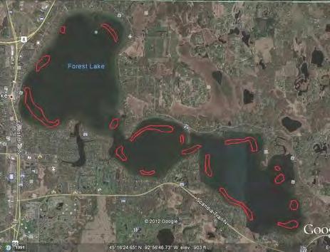
11 Forest Lake Curlyleaf Treatment Areas for Figure S2. Curlyleaf treatment areas in 2009 through ii-

. Figure S3. [left] DELINEATION: Map of EWM distribution from the June 10, 2016 survey. Approximately 13.")
12 Eurasian Watermilfoil (EWM) Delineation, Treatment, and Assessment: EWM distribution and abundance were evaluated June 10, Based on that delineation, a total of 13.9 acres on the 2,271 acre lake were treated on July 18 to control heavy growth of Eurasian watermilfoil. About 2 months after the EWM treatment, an EWM assessment on September 15, 2016 found good control in the treated areas with mostly light growth in a few scattered spots. No EWM was observed in Lakes 2 and 3 in 2016 (Figure S3). Figure S3. [left] DELINEATION: Map of EWM distribution from the June 10, 2016 survey. Approximately 13.9 acres were delineated for EWM treatment. [right] ASSESSMENT: Map of EWM assessment on September 15, Key: green dots = light growth, yellow dots = moderate growth, red dots = heavy growth, and black dots = no EWM growth. Forest Lake EWM Treatment Areas for 2015 and 2016 Figure S4. Curlyleaf treatment areas in 2015 and iii-

13 Flowering Rush in Forest Lake, July, 2016 Flowering Rush Delineation, Control, and Assessment for Forest Lake, Washington County, Minnesota, 2016 Delineation: July 14 and 15, 2016 Herbicide Treatments on 36 acres: August 3 and 31, 2016 Assessment: September 21, 2016 Prepared for: Washington County and Comfort Lake/Forest Lake Watershed District Prepared by: Steve McComas Blue Water Science December 2016
14 Flowering Rush Delineation, Control, and Assessment for Forest Lake, Washington County, Minnesota, 2016 Summary In 2016, Forest Lake flowering rush coverage was delineated at 83,189 square feet (1.9 acres) on July 14 and 15, 2016 (Table S1). After controlling flowering rush with herbicide treatments, flowering rush coverage was found to have decreased to 9,183 square feet (0.21 acres) on the assessment survey on September 21, This was a decrease of flowering rush coverage of 89%. Most of the area that decreased was from large flowering rush beds that were treated twice with a diquat herbicide. Only 3 new sites, small in area, appeared from July to September in The third year of the flowering rush program was At the end of 2016, a total of 243 sites of flowering rush had been observed from 2014 to On the September 21, 2016 assessment date, 81 sites of flowering rush were observed. The area of flowering rush decreased from October of 2014 to September of 2016 indicating the flowering rush control program was reducing the distribution and density of flowering rush. Although the estimated total area of flowering rush was around 0.21 acres in September of 2016, a typical flowering rush response is for regrowth from the rhizomes and some regrowth would be expected in Continuing to control areas of flowering rush should reduce abundant regrowth but it appears eradication will be a challenge. The steps for controlling flowering rush in the next few years include the following three methods. 1. Continue treating large areas of flowering rush with diquat. 2. Cut or treat small patches 2 or 3 times/season. 3. Continue to remove flowerheads before seeds are produced which should help reduce areas of flowering rush colonization. Table S1. Summary of flowering rush sites and areas for 2014, 2015, and July 22, 2014 (Delineation) Number of sites with plants 1 st Lake 2 nd Lake 3 rd Lake Total Area Area Area Number of (sf) (sf) (sf) sites with Number of sites with plants Number of sites with plants , ,990 (estimated based on Oct 8 survey) plants 34+ (not including 3 rd lake) Area (sf) 340,740 (estimated) 2 nd Lake was treated with diquat on September 9, 2014 October 8, , , ,125 (Assessment) July 17, 2015 (Delineation) , , ,299 2 nd and 3 rd Lakes were treated by cutting in July and August; 3 rd Lake treated with diquat twice in August, 2015 September 28, 2015 (Assessment) , ,411 (new sites compared to 2014) (11) -- (13) -- (25) -- (49) -- July 14 and 15, 2016 (Delineation) , , ,189 2 nd and 3 rd Lakes were treated with diquat twice in August, 2016 September 21, 2016 (Assessment) , ,183 (new sites compared to 2015) (0) -- (0) -- (3) Summary - i
.")
15 Initial Flowering Rush Delineation - July 14-15, 2016 A flowering rush delineation was conducted on July 14-15, A total of 182 flowering rush sites with areas ranging from 5 square feet to greater than 1,000 square feet were found (Figure S1). A majority of the flowering rush sites were small and somewhat scattered in the nearshore area often in water depths of less than 3 feet. Although 3 areas of continuous flowering rush beds were delineated, many of the small patches could be considered to be continuous as well. A total area of 83,189 square feet of flowering rush was estimated in the July delineation. Figure S1. Flowering rush delineation on July 14-15, Summary - ii

16 Flowering Rush Treatment Map A total of 36 acres of flowering rush was treated with diquat on two occasions on August 3 and August 31. Although the area of flowering rush did not total 36 acres, previous treatment research in the Detroit Lakes area found treating large areas was more effective than treating small, individual patches. The applicator delineated the large areas to be treated. A number of small patches were treated as well. Also an area of about 600 square feet by a public access on Lake 2 was handcut on several dates by CLFLWD staff as an experiment. Figure S2. Flowering rush treatment areas for August 3, and 31, Summary - iii
. Flowering rush was found at 81 sites, mostly in small patches of less than 100 square feet. Figure S3.")
17 Flowering Rush Assessment About 3 weeks after the August 31 diquat application, flowering rush sites in Forest Lake were assessed. Except for 2 areas in 3 rd Lake, flowering rush control was very good (Figure S3). Flowering rush was found at 81 sites, mostly in small patches of less than 100 square feet. Figure S3. Flowering rush assessment on September 21, Summary - iv

18 Underwater View of Coontail with Attached Filamentous Algae in Comfort Lake on June 14, 2016 Curlyleaf Pondweed and Eurasian Watermilfoil Delineation, Treatment, and Assessment for Comfort Lake and Little Comfort Lake, Chisago County, 2016 Delineation Treatment Assessment CLP April 15, 2016 No treatment June 14, 2016 EWM May 6 and 22, 2016 May 11, 2016 (7.5 acres) June 14 and September 14, 2016 Prepared for: Comfort Lake/Forest Lake Watershed District Forest Lake, Minnesota December 2016 Prepared by: Steve McComas Jo Stuckert Blue Water Science

.")
19 Curlyleaf Pondweed and Eurasian Watermilfoil Delineation, Treatment, and Assessment for Comfort Lake and Little Comfort Lake, Chisago County, 2016 Summary Curlyleaf Pondweed Delineation and Assessment Surveys: A curlyleaf pondweed delineation for distribution and abundance was conducted on both Comfort and Little Comfort Lakes on April 15, In the delineation survey, curlyleaf was found at 1 site in Comfort Lake and at 1 site in Little Comfort (Figure S1). No areas were delineated for treatment. About 2 months later, in the June curlyleaf assessment, curlyleaf was found at 5 sites in Comfort and at 2 sites in Little Comfort. Where curlyleaf was present, growth was light in June (Figure S1). Figure S1. [left] DELINEATION: Map of curlyleaf pondweed distribution on the April 15, 2016 survey. TREATMENT: No curlyleaf pondweed treatment was conducted in [right] ASSESSMENT: Map of curlyleaf pondweed assessment sites for June 14, Key: black dot = no curlyleaf, green dot = light growth, yellow dot = moderate growth, and red dot = heavy growth. -i-
.")


20 Eurasian Watermilfoil (EWM) Delineation, Treatment, and Assessment Surveys: An Eurasian watermilfoil delineation for distribution and abundance was conducted on May 6, 2016 and EWM was found at 72 sites. Four treatment areas totaling 7.5 acres were delineated. Treatment of the 7.5 acres in 4 areas occurred on May 11 (Figure S2). A subsequent EWM follow-up survey occurred on May 22 and additional EWM that was missed on the May 6 delineation was observed primarily in the southeast end of Comfort Lake (Figure S2). After the May 11 treatment, which was based on the May 6 delineations, EWM had decreased and was found at 19 sites in the June 14, 2016 assessment. EWM growth was light to moderate with good control in the treated areas (Figure S2). At the end of the summer, another EWM assessment was conducted. EWM was found to have sprouted in a number of new spots including new areas on the western shore in the nearshore area around Comfort Lake. A total of 58 EWM sites were found. It appears EWM is fairly well distributed around much of Comfort Lake in relatively shallow water, generally less than 5 feet. Figure S2. [top-left] DELINEATION: Map of EWM distribution from the May 6 and 22, 2016 survey. [top-right] ASSESSMENT: Map of EWM sites for June 14, [bottom-left] ASSESSMENT: Map of EWM sites for September 14, TREATMENT: EWM treatment occurred on May 11, Key: black dot = no curlyleaf, green dot = light growth, yellow dot = moderate growth, and red dot = heavy growth. -ii-
Fish Survey of Arctic Lake (ID # ), Scott County, Minnesota in 2012
, Scott County, Minnesota in 2012") Snapping Turtle from Arctic Lake, September 2012 Fish Survey of Arctic Lake (ID #70-0085), Scott County, Minnesota in 2012 Survey Dates: September 18-20, 2012 MnDNR Permit Number: 18362 Prepared for: Shakopee
Snapping Turtle from Arctic Lake, September 2012 Fish Survey of Arctic Lake (ID #70-0085), Scott County, Minnesota in 2012 Survey Dates: September 18-20, 2012 MnDNR Permit Number: 18362 Prepared for: Shakopee
Aquatic Plant Point-Intercept Survey for Pike Lake, Scott County, Minnesota
 Campers on Pike Lake, Scott County, Minnesota, 2015 Aquatic Plant Point-Intercept Survey for Pike Lake, Scott County, Minnesota [Plant Survey Conducted August 24, 2015] Prepared for: Prior Lake/Spring
Fish Survey of Goose Lake (ID # ), Ramsey County, Minnesota in 2012
, Ramsey County, Minnesota in 2012") Softshell Turtle from Goose Lake, July 2012 Fish Survey of Goose Lake (ID #62-0034), Ramsey County, Minnesota in 2012 Survey Dates: July 16-18, 2012 MnDNR Permit Number: 18362 Prepared for: VLAWMO and
Softshell Turtle from Goose Lake, July 2012 Fish Survey of Goose Lake (ID #62-0034), Ramsey County, Minnesota in 2012 Survey Dates: July 16-18, 2012 MnDNR Permit Number: 18362 Prepared for: VLAWMO and
Aquatic Plant Point-Intercept Survey for Cates Lake, Scott County, Minnesota
 American Lotus in Cates Lake, Scott County, Minnesota, 2016 Aquatic Plant Point-Intercept Survey for Cates Lake, Scott County, Minnesota [Plant Survey Conducted August 29, 2016] Prepared for: Prior Lake-Spring
Lake information report
 Lake information report: Minnesota DNR Page of 5 Lake information report jf Prinlable senior Name: Spring Nearest Town: Spring Lake (Scott) Primary County: Scott Survey Date: 08/02/200 Inventory Number:
Big Bend Lake Population Survey
 Big Bend Lake Survey Located in Des Plaines on East River Rd. just south of Golf Rd. This 27 acre body of water has a depth of 27.8 feet; however because it is connected to the Des Plaines River by a spillway,
Shallow Lake Management Strategies. Steve McComas Blue Water Science Shallow Lakes Forum April 2014
 Shallow Lake Management Strategies Steve McComas Blue Water Science Shallow Lakes Forum April 2014 Shallow Lakes and Ponds Are Similar Shallow Lake Goal: Clear water and macrophytes. Clear Turbid Aquatic
Cedar Lake Comprehensive Survey Report Steve Hogler and Steve Surendonk WDNR-Mishicot
 Cedar Lake- 2006 Comprehensive Survey Report Steve Hogler and Steve Surendonk WDNR-Mishicot ABSTRACT Cedar Lake is a 142 acre lake located in the southwest corner of Manitowoc County. It is a seepage lake
Current Status and Management Recommendations for the Fishery in the Cloverleaf Chain of Lakes
 Current Status and Management Recommendations for the Fishery in the Cloverleaf Chain of Lakes Jason Breeggemann Senior Fisheries Biologist Wisconsin Department of Natural Resources Outline DNR fisheries
Penny Road Pond Population Survey
 Located in Barrington Hills on the south side of Penny Rd. west of Old Sutton Rd. This small 7 acre pond has a maximum depth of 4.6 feet and is connected to Spring Creek. The fish population of Penny Road
Waupaca Chain O' Lakes Anonymous Stakeholder Survey Surveys Distributed: 804 Surveys Returned: 432 Response Rate: 54% Chain Property
 Waupaca Chain O' Lakes Anonymous Stakeholder Survey Surveys Distributed: 84 Surveys Returned: 432 Rate: 54% Chain Property 1. On which lake of the Chain do you reside or own property? Percent Columbia
MARTINDALE POND Wayne County 2004 Fish Management Report. Christopher C. Long Assistant Fisheries Biologist
 MARTINDALE POND Wayne County 2004 Fish Management Report Christopher C. Long Assistant Fisheries Biologist Fisheries Section Indiana Department of Natural Resources Division of Fish and Wildlife I.G.C.
Rolling Knolls Pond Population Survey
 Located near the town of Elgin on the west side of Rohrssen Rd. between Illinois Route 58 and U.S.- 20. This small 1.8 acre pond has a maximum depth of 7.5 feet and is occasionally influenced by Poplar
Leech Lake Update 5/20/2009 Walker Area Fisheries Office State Hwy. 371 NW Walker, MN
 Frequency (N) Leech Lake Update 5/20/2009 Walker Area Fisheries Office 07316 State Hwy. 371 NW Walker, MN 56484 218-547-1683 Greetings! This update is part of a series of reports the Minnesota Department
Busse Reservoir South Lateral Pool Population Survey
 Busse Reservoir South Lateral Pool Survey Located in Elk Grove Village south of Higgins Rd. between RT 53/I-290 and Arlington Heights Rd. Busse Reservoir is comprised of three pools making up a total of
2014 Threatened and Endangered Fish Survey of. East Loon Lake and West Loon Lake. Lake County, Illinois
 2014 Threatened and Endangered Fish Survey of East Loon Lake and West Loon Lake Lake County, Illinois Prepared by Integrated Lakes Management 120 LeBaron St. Waukegan, IL 60085. Chris Ryan Chris Rysso
Michigan Dept. of Natural Resources Status of the Fishery Resource Report Page 1. Weber Lake Cheboygan County, T34N, R3W, Sec.
 Michigan Dept. of Natural Resources 2012-143 Status of the Fishery Resource Report Page 1 Weber Lake Cheboygan County, T34N, R3W, Sec. 31 Neal Godby, Fisheries Biologist Environment Weber Lake is a 28.5-acre
I Region I Area I DOW Number / County I DOW Lake Name I Acreage I
 LAKE MANAGEMENT PLAN 814 Bp I Region I Area I DOW Number / County I DOW Lake Name I Acreage I I I # I f 2 Duluth F213 690036 St Louis Salo DOW:149 Plan: 137 Long Range Goal: Manage for walleye with a gillnet
LAKE DIANE Hillsdale County (T8-9S, R3W, Sections 34, 3, 4) Surveyed May Jeffrey J. Braunscheidel
 Surveyed May Jeffrey J. Braunscheidel") Michigan Department of Natural Resources Status of the Fishery Resource Report No. 2003-4, 2003 LAKE DIANE Hillsdale County (T8-9S, R3W, Sections 34, 3, 4) Surveyed May 2001 Jeffrey J. Braunscheidel Environment
Michigan Department of Natural Resources Status of the Fishery Resource Report No. 2003-4, 2003 LAKE DIANE Hillsdale County (T8-9S, R3W, Sections 34, 3, 4) Surveyed May 2001 Jeffrey J. Braunscheidel Environment
Tampier Lake Population Survey
 Located in Palos Park on 131 st St. between Wolf and Will-Cook Rd. s. Tampier Lake has 131 acres of fishable water, with a maximum depth of 9.4 feet. Walleye, northern pike, largemouth bass and channel
Sag Quarry - West Population Survey
 Located in Lemont on RT 83 and Archer Ave. just north of 111 th St. Like Sag Quarry East, this lake is an old limestone quarry, 14 acres in size and with a maximum depth of 10.3 feet. The species found
MIDDLE FORK RESERVOIR Wayne County 2004 Fish Management Report. Christopher C. Long Assistant Fisheries Biologist
 MIDDLE FORK RESERVOIR Wayne County 2004 Fish Management Report Christopher C. Long Assistant Fisheries Biologist FISHERIES SECTION INDIANA DEPARTMENT OF NATURAL RESOURCES DIVISION OF FISH AND WILDLIFE
Fisheries Survey of Saratoga Lake
 Fisheries Survey of Saratoga Lake 7- Mark D. Cornwell Kevin Poole State University of New York College of Agriculture & Technology Department of Fisheries & Wildlife Cobleskill, NY ABSTRACT: This survey
JadEco, LLC PO BOX 445 Shannon, IL 61078
 Introduction: With the assistance of Lake Holiday staff and volunteers, we were able to conduct an AC electrofishing survey on May 8, 27. Water temperatures were 2.3 C (8.5 F) and water clarity was decent
CORRESPONDENCE/MEMORANDUM
 CORRESPONDENCE/MEMORANDUM State of Wisconsin DATE: November 13, 2012 FILE REF: [Click here and type file ref.] TO: FROM: Mike Donofrio Harpt Lake File Steve Hogler SUBJECT: 2012 Harpt Lake Electrofishing
DOW# West Twin Lake
 DOW# 69-0696 West Twin Lake West Twin Lake has a surface area of 120.4 acres and is located on the east side of St. Louis County Road 31, south of Highway 2. West Twin Lake has a maximum depth of 18 feet
Aquatic Plant Management and Importance to Sport Fisheries
 Aquatic Plant Management and Importance to Sport Fisheries Presentation to Michigan Inland Lakes Convention May 2014 Mike Maceina Professor Emeritus School of Fisheries, Aquaculture, and Aquatic Sciences
Bode Lake - South Population Survey
 Bode Lake - South Survey Located in Hoffman Estates on the north side of Bode Rd. 1 mile west of Barrington Rd. Bode Lake is made up of two lakes along Poplar Creek; the larger and deeper Bode Lake South
Inventory # Perch Lake
 Inventory # 9-036 Perch Lake Perch Lake is a double-basin lake. The southern, shallow portion of the lake is 414 acres, making it the largest wild rice lake on the Reservation. The fish communities sampled
Lake information report
 Page of 5 Lake information report Name: Whitewater Nearest Town: Hoyt Lakes Primary County: St. Louis Survey Date: 08/3/2007 Inventory Number: 69037600 Public Access Information Ownership Type Description
Fish Survey of Parkers Lake (ID # ), City of Plymouth, Hennepin County, Minnesota in 2013
, City of Plymouth, Hennepin County, Minnesota in 2013") Northern Pike from Parkers Lake, July, 2013 Fish Survey of Parkers Lake (ID #270107), City of Plymouth, Hennepin County, Minnesota in 2013 Survey Dates: July 2324, 2013 MnDNR Permit Number: 19241 Prepared
Northern Pike from Parkers Lake, July, 2013 Fish Survey of Parkers Lake (ID #270107), City of Plymouth, Hennepin County, Minnesota in 2013 Survey Dates: July 2324, 2013 MnDNR Permit Number: 19241 Prepared
Schiller Pond Population Survey
 Located in the town of Schiller Park on Irving Park Rd. just west of Cumberland Ave. This small 6 acre pond has a maximum depth of 6.3 feet. In addition to largemouth bass and bluegill, Schiller Pond is
Crooked Lake Oakland County (T4N, R9E, Sections 3, 4, 9) Surveyed May James T. Francis
 Surveyed May James T. Francis") Michigan Department of Natural Resources Status of the Fishery Resource Report No. 2004-1, 2004 Crooked Lake Oakland County (T4N, R9E, Sections 3, 4, 9) Surveyed May 2002 James T. Francis Environment Crooked
Michigan Department of Natural Resources Status of the Fishery Resource Report No. 2004-1, 2004 Crooked Lake Oakland County (T4N, R9E, Sections 3, 4, 9) Surveyed May 2002 James T. Francis Environment Crooked
Lake Winnibigoshish Fisheries Information Newsletter
 Lake Winnibigoshish Fisheries Information Newsletter 03/21/2016 An annual fisheries newsletter for Lake Winnibigoshish In This Issue 2016 Population Assessment Invasive Species VHS Interesting Links Invasive
Fish Community and Aquatic Ecosystem Responses to the Cessation of Eurasian Watermilfoil Chemical Treatment on Lake Ellwood, Wisconsin
 Fish Community and Aquatic Ecosystem Responses to the Cessation of Eurasian Watermilfoil Chemical Treatment on Lake Ellwood, Wisconsin Greg G. Sass Wisconsin Department of Natural Resources Fisheries and
2010 Fishing Opener Prognosis. Central Region
 2010 Fishing Opener Prognosis Central Region Hinckley PINE COUNTY Pokegama, Cross, Island, Oak and North and South Big Pine Lakes are typically the best lakes for targeting walleye in Pine County. They
Lake information report
 Page 1 of 6 Lake information report Name: Saganaga Nearest Town: Grand Marais Primary County: Cook Survey Date: 08/08/2011 Inventory Number: 16063300 walleye stocking. Purchase a walleye stamp. Your voluntary
Caro Impoundment, Tuscola County
 Caro Impoundment is a 200 acre impoundment of the Cass River located one mile south of the Village of Caro in Tuscola County. Caro Dam, originally constructed in 1906 for water supply to Michigan Sugar
Chateaugay Lakes Milfoil Control Program
 Chateaugay Lakes Milfoil Control Program Summary of Activities and Findings for June August 29 Prepared By: Daniel L. Kelting Executive Director Adirondack Watershed Institute Paul Smith's College P.O.
Wampum Lake Population Survey
 Wampum Lake Survey Located in Thornton on Thornton-Lansing Rd. 1½ mile west of Torrence Ave. Wampum Lake is 35 acres is size and has a maximum depth of 14.1 feet. Northern pike, largemouth bass, bluegill,
BIG TWIN LAKE Kalkaska County (T28N, R05W, Section 18, and T28N, R06W, Section 13) Surveyed May 1999
 Surveyed May 1999") Michigan Department of Natural Resources Status of the Fishery Resource Report No. 2001-1, Year 2001 BIG TWIN LAKE Kalkaska County (T28N, R05W, Section 18, and T28N, R06W, Section 13) Surveyed May 1999
Michigan Department of Natural Resources Status of the Fishery Resource Report No. 2001-1, Year 2001 BIG TWIN LAKE Kalkaska County (T28N, R05W, Section 18, and T28N, R06W, Section 13) Surveyed May 1999
Quemahoning Reservoir
 Pennsylvania Fish & Boat Commission Biologist Report Quemahoning Reservoir Somerset County May 2011 Trap Net, Gill Net and Electrofishing Survey Quemahoning Reservoir is an 899 acre impoundment located
Preventing Aquatic Invasive Species
 Preventing Aquatic Invasive Species Photo by: Alison Fox, University of Florida, Bugwood.org Photo by: Chris Evans, Illinois Wildlife Action Plan, Bugwood.org Many drops make a bucket, many buckets make
Spring Coming This Spring! Walleye Population and Angler Study (Page 5)
") Spring 2019 Coming This Spring! Walleye Population and Angler Study (Page 5) SPRING NEWSLETTER, 2019 Lake Washington Improvement Assn. PO Box 68 Dassel, MN 55325 www.lakewashingtonassn.com Email: info@lakewashingtonassn.com
Spring 2019 Coming This Spring! Walleye Population and Angler Study (Page 5) SPRING NEWSLETTER, 2019 Lake Washington Improvement Assn. PO Box 68 Dassel, MN 55325 www.lakewashingtonassn.com Email: info@lakewashingtonassn.com
McGinty Slough Population Survey
 Located in Lemont, north of 131 st St and west of Will-Cook Rd. and is 38 acres with a depth of 8.2 feet. This lake is walk in access only, to access the lake walk the multi-use trail ether from 131 st
O Malley s Ponds Population Survey
 O Malley s Ponds Survey The newest fishing lake within the Forest Preserves of Cook County, O Malley Ponds were acquired by the District in 2005. Located in Sauk Village at the intersection of Sauk Trail
Maple Lake Population Survey
 Maple Lake Survey Located in Willow Springs approximately 1 mile west of Willow Springs Rd. (104 th Ave.) at Wolf Rd. and 95 th St. Constructed in the 1920 s this 60 acre lake drops down to 20.4 feet in
Trapnet Fish Surveys for Sweeney Lake ( ) and Twin Lake ( ), Hennepin County, September 17-19, 2013
 and Twin Lake ( ), Hennepin County, September 17-19, 2013") Trapnet catch from Sweeney Lake, September 2013 Trapnet Fish Surveys for Sweeney Lake (27-0035-01) and Twin Lake (27-0035-02), Hennepin County, September 17-19, 2013 MnDNR Permit Number 19414 Submitted
Trapnet catch from Sweeney Lake, September 2013 Trapnet Fish Surveys for Sweeney Lake (27-0035-01) and Twin Lake (27-0035-02), Hennepin County, September 17-19, 2013 MnDNR Permit Number 19414 Submitted
Lake St. Clair Fish Community and Fishery
 Lake St. Clair Fish Community and Fishery Megan Belore Ontario Ministry of Natural Resources and Forestry Mike Thomas Michigan Department of Natural Resources Fish Community Fish Community Mixture of warm
Upper/Lower Owl Creek Reservoir
 Upper/Lower Owl Creek Reservoir Schuylkill County 2018 Largemouth Bass Survey Upper Owl Creek Reservoir and Lower Owl Creek Reservoir are 67-acre and 26-acre impoundments, respectively, created by two
Pennsylvania Fish & Boat Commission Biologist Report. Wilmore Dam. Cambria County. May 2011 Trap Net, Electrofishing and Hoop Net Survey
 Pennsylvania Fish & Boat Commission Biologist Report Wilmore Dam Cambria County May 2011 Trap Net, Electrofishing and Hoop Net Survey Wilmore Dam is a 195 acre impoundment located in central Cambria County
NW REGION OUTLOOK FOR 2018 FISHING OPENER. April 17, 2018
 NW REGION OUTLOOK FOR 2018 FISHING OPENER April 17, 2018 Ice-out across Northwest Minnesota will be much later than normal this spring. The snowpack across much of the region is 6-12 inches with 24-36
Waubee Lake Kosciusko County Fish Management Report 2006
 Waubee Lake Kosciusko County Fish Management Report 2006 Jed Pearson, fisheries biologist Fisheries Section Indiana Department of Natural Resources Division of Fish and Wildlife I.G.C.-South, Room W273
LAKE MANAGEMENT PLAN
 LAKE MANAGEMENT PLAN Region Area DOW Number County DOW Lake Name Acreage 2 Duluth F213 69-0041 St. Louis Bassett DOW: 436 Plan: 442 Long Range Goal: Manage for walleye with a gillnet catch rate greater
Summary of and Initial Response to public comments on MN Department of Natural Resources proposal to manage new waters for Muskellunge
 Summary of and Initial Response to public comments on MN Department of Natural Resources proposal to manage new waters for Muskellunge Summary of and Initial Response to public comments: This document
BEAVER DAM LAKE Kosciusko County 2005 Fish Management Report. Angela C. Benson Assistant Biologist
 BEAVER DAM LAKE Kosciusko County 2005 Fish Management Report Angela C. Benson Assistant Biologist Fisheries Section Indiana Department of Natural Resources Division of Fish and Wildlife I.G.C.-South, Room
Mud Bay SLELO-PRISM Water Chestnut & Hydrilla Surveillance 2012
 St. Lawrence Eastern Lake Ontario Partnership for Regional Invasive Species Management Mud Bay Water Chestnut & Hydrilla Surveillance 2012 June 27 th (Water Chestnut) & August 2 (Hydrilla), 2012 Figure
SOONER LAKE MANAGEMENT PLAN
 SOONER LAKE MANAGEMENT PLAN Background Lake Sooner impounds Greasy Creek, 15 miles south of Ponca City in Noble and Pawnee Counties, Oklahoma (Figure 1). The Grease Creek basin that Sooner Lake impounds
KICKAPOO LAKE Shakamak State Park Sullivan, Greene, and Clay Counties 2009 Fish Management Report. David S. Kittaka Fisheries Biologist
 KICKAPOO LAKE Shakamak State Park Sullivan, Greene, and Clay Counties 2009 Fish Management Report David S. Kittaka Fisheries Biologist Fisheries Section Indiana Department of Natural Resources Division
A SURVEY OF THE PRETTY LAKE FISH COMMUNITY, LARGEMOUTH BASS AND WALLEYE POPULATIONS AND FISH HARVEST LaGrange County 2010
 A SURVEY OF THE PRETTY LAKE FISH COMMUNITY, LARGEMOUTH BASS AND WALLEYE POPULATIONS AND FISH HARVEST LaGrange County 2010 Larry A. Koza Assistant Fisheries Biologist Fisheries Section Indiana Department
Status Review and Management Outline for Quality Bluegill and Black Crappie Populations in the Grand Rapids Area.
 Status Review and Management Outline for Quality Bluegill and Black Crappie Populations in the Grand Rapids Area. Revised in 2013 By David L. Weitzel Assistant Area Fisheries Supervisor MN DNR, Grand Rapids
LAKE PLEASANT Steuben County 2006 Fish Management Report. Larry A. Koza Assistant Fisheries Biologist
 LAKE PLEASANT Steuben County 2006 Fish Management Report Larry A. Koza Assistant Fisheries Biologist Fisheries Section Indiana Department of Natural Resources Division of Fish and Wildlife I.G.C.-South,
2014 Island Lake Survey June 13 th, 2014 Andrew Plauck District Fisheries Biologist Report Prepared 4 March 2015
 2014 Island Lake Survey June 13 th, 2014 Andrew Plauck District Fisheries Biologist Report Prepared 4 March 2015 BACKGROUND - A fish survey was requested due to a moderately severe winterkill in Island
Starry Stonewort in Silver Lake Washington County, WI BRAD STECKART AIS COORDINATOR FOR WASHINGTON AND WAUKESHA COUNTIES
 Starry Stonewort in Silver Lake Washington County, WI BRAD STECKART AIS COORDINATOR FOR WASHINGTON AND WAUKESHA COUNTIES Brad Steckart -AIS coordinator for Washington and Waukesha Counties -Graduated from
Introduction: JadEco, LLC PO BOX 445 Shannon, IL 61078
 Introduction: was contacted to collected data on the fishery for Lake Holiday. AC Electroshocking was conducted at 2 locations on September 28, 2015. Fish population data was collected for a total of 100
Fisheries Survey of White Rapids Flowage, Marinette County Wisconsin during Waterbody Identification Code
 Fisheries Survey of White Rapids Flowage, Marinette County Wisconsin during 25 Waterbody Identification Code 6343 Michael Donofrio Fisheries Supervisor Wisconsin Department of Natural Resources Peshtigo,
December 18, Dear Sir/Madam,
 December 18, 2000 Dear Sir/Madam, We are writing to bring you up-to-date on our efforts to develop fish community objectives for the St. Lawrence River. First of all, we want to thank you for participating
Pond Management. Dan Lekie Agriculture & Natural Resource Agent K-State Research & Extension Johnson County
 Pond Management Dan Lekie Agriculture & Natural Resource Agent K-State Research & Extension Johnson County Pond Management Basics Plant ID and Control Fish Management Wildlife Concerns Management Options
Arrowhead Lake Population Survey
 Located in Palos Heights at 135 th St, east of Harlem Ave. Arrowhead Lake is a 13 acre body of water with a maximum depth of 12.6 feet. Fish species found in this lake include largemouth bass, bluegill,
Fish Assesment of Lake Nokomis (ID # ), Hennepin County, Minnesota in 2008
, Hennepin County, Minnesota in 2008") Lake Nokomis, July 10, 2008 Fish Assesment of Lake Nokomis (ID #27-0019), Hennepin County, Minnesota in 2008 Survey Dates: July 10-11, 2008 MnDNR Permit Number: 15384 Submitted to: Minneahaha Creek Watershed
Lake Nokomis, July 10, 2008 Fish Assesment of Lake Nokomis (ID #27-0019), Hennepin County, Minnesota in 2008 Survey Dates: July 10-11, 2008 MnDNR Permit Number: 15384 Submitted to: Minneahaha Creek Watershed
Job 1 Part JOB 1, PART 2: SUMMARY OF CONOWINGO DAM WEST FISH LIFT OPERATIONS, 2009
 2.0 JOB 1, PART 2: SUMMARY OF CONOWINGO DAM WEST FISH LIFT OPERATIONS, 2009 Lawrence M. Miller Normandeau Associates U. S. Fish and Wildlife Service 1921 River Road Harrisburg, Pennsylvania Drumore, Pennsylvania
An Assessment of the Fish Community in Lake Acworth
 An Assessment of the Fish Community in Lake Acworth By John Damer Fisheries Biologist Georgia Department of Natural Resources Wildlife Resources Division Fisheries Section Calhoun, GA 30701 July 2008 Introduction
NEVADA DEPARTMENT OF WILDLIFE STATEWIDE FISHERIES MANAGEMENT
 NEVADA DEPARTMENT OF WILDLIFE STATEWIDE FISHERIES MANAGEMENT FEDERAL AID JOB PROGRESS REPORTS F-20-48 2012 RYE PATCH RESERVOIR WESTERN REGION NEVADA DEPARTMENT OF WILDLIFE, FISHERIES DIVISION JOB PROGRESS
Onondaga Lake Fishery: 2011 Fact Sheet
 October, 2011 Onondaga County Department of Water Environment Protection SUNY College of Environmental Science and Forestry Joanne M. Mahoney, County Executive Tom Rhoads, P.E., Commissioner Onondaga Lake
Green Lake Population Survey
 Located next to the Green Lake Aquatic Center in Calumet City on the north side of 159 th St, east of Torrence Ave. Size can be deceiving; this 5 acre lake is the deepest lake in the District with a maximum
CARL BLACKWELL LAKE MANAGEMENT PLAN
 CARL BLACKWELL LAKE MANAGEMENT PLAN Background Lake Carl Blackwell impounds Stillwater Creek, 10 miles west of Stillwater in Payne County, Oklahoma (Figure 1). The lake covers 3,370 surface acres and was
RLAA 2018 Annual Meeting Minutes May 1, 2018
 RLAA 2018 Annual Meeting Minutes May 1, 2018 The Rice Lake Area Association (RLAA) held their annual members meeting on Tuesday, May 1st from 6:30-9:30 pm at the Cambria Suites motel in Maple Grove. The
SKIATOOK LAKE MANAGEMENT PLAN
 SKIATOOK LAKE MANAGEMENT PLAN Background Skiatook Lake impounds Hominy Creek, 5 miles west of Skiatook in Osage County, Oklahoma (Figure 1). Skiatook Lake covers 10,540 surface acres and was constructed
Delaware River Seine Survey: 2012 Sampling Summary
 Delaware River Seine Survey: 2012 Sampling Summary Fish and Wildlife employees pull in the seine net From June 18 to November 21, 2012, biologists conducted the Delaware River Seine Survey. Over the course
MIDDLE FORK RESERVOIR Wayne County 2006 Fish Management Report. Christopher C. Long Assistant Fisheries Biologist
 MIDDLE FORK RESERVOIR Wayne County 2006 Fish Management Report Christopher C. Long Assistant Fisheries Biologist Fisheries Section Indiana Department of Natural Resources Division of Fish and Wildlife
Crawford Reservoir. FISH SURVEY AND MANAGEMENT INFORMATION Eric Gardunio, Fish Biologist Montrose Service Center
 FISH SURVEY AND MANAGEMENT INFORMATION General Information: Crawford Reservoir is a popular fishery that provides angling opportunity for yellow perch, channel catfish, northern pike, rainbow trout, black
Proposed Changes to Bag and Size Limits Minnesota/Wisconsin Border Waters of the Mississippi River
 Proposed Changes to Bag and Size Limits Minnesota/Wisconsin Border Waters of the Mississippi River The Minnesota and Wisconsin DNRs are jointly reviewing fishing regulations on Pools 3-9 of the Mississippi
LAKE SURVEY REPORT DRAFT VERSION PRELIMINARY DATA (AS OF 08/24/2018) Fisheries Management. DOW Number: Survey ID Date: 08/21/2018
 Fisheries Management. DOW Number: Survey ID Date: 08/21/2018") Fisheries Management DRAFT VERSION PRELIMINARY DATA (AS OF 8//8) Lake Name: Sisseton Survey Type: Standard Survey DOW Number: 6-- Survey ID Date: 8//8 Lake Identification Alternate Lake Name: Primary Lake
Fisheries Management DRAFT VERSION PRELIMINARY DATA (AS OF 8//8) Lake Name: Sisseton Survey Type: Standard Survey DOW Number: 6-- Survey ID Date: 8//8 Lake Identification Alternate Lake Name: Primary Lake
KEY. Drought: On a scale of 1 5 with more icons meaning the. species has a high growth rate.
 KEY Growth: On a scale of 1 5, with more icons meaning the species has a high growth rate. Reproduction: On a scale of 1 5 with more icons meaning the species has a high reproductive rate. Spread: On a
Beaver Creek Reserve Meets Success In 6-County AIS Prevention Effort. Anna Mares Beaver Creek Reserve April 13 th, 2011
 Beaver Creek Reserve Meets Success In 6-County AIS Prevention Effort Anna Mares Beaver Creek Reserve April 13 th, 2011 Outline Beaver Creek Reserve Five-county AIS Survey of Lakes With Public Access in
SUMMARY REPORT FOR LAKE ST. MALO FISHERIES ASSESSMENT. Prepared for the St. Malo and District Wildlife Association
 SUMMARY REPORT FOR LAKE ST. MALO FISHERIES ASSESSMENT Prepared for the St. Malo and District Wildlife Association Presented by August 25, 2014 Study dates thus far: Date Tasks February 16 Fishing derby;
NURSERY POND Fish Management Report. Jason C. Doll Assistant Fisheries Biologist
 NURSERY POND 2004 Fish Management Report Jason C. Doll Assistant Fisheries Biologist FISHERIES SECTION INDIANA DEPARTMENT OF NATURAL RESOURCES DIVISION OF FISH AND WILDLIFE I.G.C. South, Room W273 402
Status of Lake Erie s Western Basin Fish Populations: Trends and Environmental Conditions
 Status of Lake Erie s Western Basin Fish Populations: Trends and Environmental Conditions Jeff Tyson Ohio Department of Natural Resources Ohio Division of Wildlife Status of the Lake Erie s Western Basin
REEL FACTS. Regulations. Limblines Fishing with limblines and set hooks is prohibited at Lake Washington.
 Lake Washington 19 REEL FACTS Nathan Aycock Fisheries Biologist NathanA@mdwfp.state.ms.us (61) 432-2 General Information: Lake Washington is a 3, acre oxbow lake of the Mississippi River. It is one of
Ebert Lake 8 Lime Lake - 13
 8 - Number of responses Number of Responses Amount of Aquatic Plant Growth..5..5. Amount of aquatic plant growth.5 7. very_little right_amount dense_growth not_sure no_response 6 5 Dense_growth Choked_growth
Lake wide Milfoil Management Efforts
 Lake Winnipesaukee Lake wide Milfoil Management Efforts Gilford Island Association Winter Meeting March 5, 2016 Presented by: Patricia Tarpey Lake Winnipesaukee Association Gilford Conservation Commission
Aquatic Invasive Species - A Case for Prevention. Background on the impact to lakes so far
 Aquatic Invasive Species - A Case for Prevention Background on the impact to lakes so far The attack against our lake legacy is well underway. We may not realize it but Aquatic Invasive Species are spreading
Warmwater Fisheries Assessments 2014
 NJDEP Division of Fish and Wildlife Bureau of Freshwater Fisheries Warmwater Fisheries Assessments 2014 New Jersey has over 400 impoundments open to the general public for fishing and thousands more in
Minnesota Department of Natural Resources
 Minnesota Department of Natural Resources Fisheries Management DRAFT VERSION - PRELIMINARY DATA (AS OF 7/7/) Lake Name: Bloody Survey Type: Standard Survey DOW Number: -4- Survey ID Date: 7// Lake Identification
NEW OAKLAND CITY LAKE Gibson County 2007 Fish Management Report. Michelle L. Weinman Assistant Fisheries Biologist
 E OAKLAD CITY LAKE Gibson County 2007 Fish Management Report Michelle L. einman Assistant Fisheries Biologist Fisheries Section Indiana Department of atural Resources Division of Fish and ildlife I. G.
Comprehensive Fisheries Survey of High Falls Reservoir, Marinette County Wisconsin during 2004 and Waterbody Identification Code
 Comprehensive Fisheries of High Falls Reservoir, Marinette County Wisconsin during 2004 and 2005 Waterbody Identification Code 540600 Justine Hasz Senior Fisheries Biologist Wisconsin Department of Natural
Minnesota Department of Natural Resources
 Minnesota Department of Natural Resources Fisheries Management Lake Name: Colby Survey Type: Population Assessment DOW Number: 699 Survey ID Date: 7// Lake Identification Alternate Lake Name: Partridge
Public Input to St. Lawrence River Fisheries Community Objectives
 Public Input to St. Lawrence River Fisheries Community Objectives Tommy L. Brown, Human Dimensions Research Unit, Cornell University Steven R. LaPan, New York State Department of Environmental Conservation,
Fishing/Outreach Survey, 2013 Report
 AGFD Aquatic Invasive Species Program Fishing/Outreach Survey, 2013 Report Location: Bartlett Lake and Lake Pleasant, Maricopa County, Arizona; Lake Havasu, Mohave County, Arizona. Date: February 2013
Fishing/Outreach Survey, 2014 Report
 AGFD Aquatic Invasive Species Program Fishing/Outreach Survey, 2014 Report Location: Bartlett Lake and Lake Pleasant, Maricopa County, Arizona; Lake Havasu, Mohave County, Arizona; Lake Powell, Cochise