Use of Conservation Moorings as a Component of Eelgrass Restoration in two Massachusetts Harbors
|
|
|
- Colleen Lamb
- 5 years ago
- Views:
Transcription


1 Use of Conservation Moorings as a Component of Eelgrass Restoration in two Massachusetts Harbors Massachusetts Bays Program Division of Marine Fisheries Jay Baker, Tay Evans, Mass Bays Program MarineFisheries
 Temperate species that ranges in North America from the Canadian Maritimes to So")
2 The Seagrass Picture in Massachusetts and Cape Cod Bay Dominant species is eelgrass (Zostera marina) Temperate species that ranges in North America from the Canadian Maritimes to Southeastern U.S. Ecosystem services range from nursery and forage habitat to sediment stabilization and shoreline protection Once abundant to the point of navigational nuisance, now declining at an alarming rate* Sensitivity to changes in water quality and other stressors have made it a sentinel of coastal environmental change
3 MassDEP Seagrass Monitoring Program Began as a comprehensive mapping effort in 1995 Delineate seagrass beds (Zostera and Rupia) in embayments and nearshore waters from 1:20,000 true color aerial photos Repeated flyovers in 2000 and 2006 to provide a 12 year picture of status and trends in eelgrass over the time period Costello, C.T. and W.J. Kenworthy Twelve year mapping and change analysis of eelgrass (Zostera marina) areal abundance in Massachusetts (U.S.A.) identifies statewide declines. Estuaries (in press)
4 MassDEP Seagrass Monitoring Program Region Median decline (% y -1 ) Massachusetts Bay South Cape Cod Buzzards Bay The Islands From Costello, C.T. and W.J. Kenworthy. 2010
5 MassDEP Seagrass Monitoring Program Area Mapped (ha) Location Gloucester Harbor (-4.21) (9.46) Salem Harbor (-33.86) (9.73) Lynn Harbor (-2.21) (0.97) Boston Harbor (-22.11) (29.22) Cohasset Harbor (0.75) (-0.88) Scituate Harbor (-2.97) 4.17 (-0.04) Duxbury/Plymouth H (-2.77) (-0.50) -3.59%/yr -0.5%/yr From Costello, C.T. and W.J. Kenworthy. 2010
6 MassDEP Seagrass Monitoring Program Area Mapped (ha) Location POTW Upgrades Gloucester Harbor (-4.21) (9.46) Salem Harbor (-33.86) (9.73) Lynn Harbor (-2.21) (0.97) Late 1990s (CSOs) Boston Harbor (-22.11) (29.22) 2000 Cohasset Harbor (0.75) (-0.88) 2000 Scituate Harbor (-2.97) 4.17 (-0.04) 2000 Duxbury/Plymouth H (-2.77) (-0.50) %/yr -0.5%/yr
 documented through this mapping effort say little about patchiness,")
7 Extent vs. Condition DEP mapping effort is the resource for tracking areal extent Large scale changes (the literal 20,000 foot view) documented through this mapping effort say little about patchiness, integrity, and condition Impacts documented by MA DEP are associated primarily with water quality There are many other localized but important impacts to eelgrass beds CSO mitigation Coastal development Boating infrastructure (navigational channels, markers, and moorings)
8
9
10
11

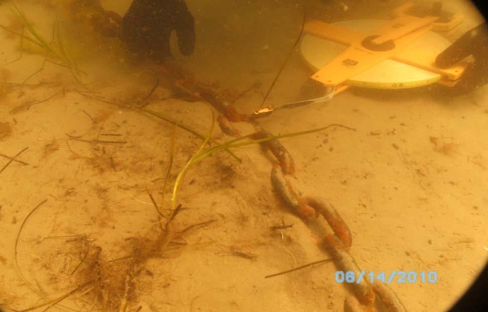
12 Notes on Moorings Traditional moorings constructed with a block and chain Chain provides scope and play and allows the vessel to swing with changing tides and wind patterns Block anchors the system to the substrate Chain drags a large circular scar in the eelgrass, creating a denuded zone, resuspending sediment, and creating a sink for detritus Block itself creates bottom shear stress and a scour area around its perimeter.


13 Notes on Moorings
 in all of Massachusetts...12,005 ha Total ha of mooring field located in eelgrass in all of Massachusetts.")
14 Intersection of Eelgrass Meadows and Mooring Fields Total hectares of eelgrass (2001) in MA Bay...3,191 ha Total ha of mooring field located in eelgrass in MA Bay...67 ha Total hectares of eelgrass (2001) in all of Massachusetts...12,005 ha Total ha of mooring field located in eelgrass in all of Massachusetts ha Eelgrass beds containing moorings in Massachusetts Bay 2.1% Number of moorings in eelgrass beds in Massachusetts Bay 402 Eelgrass beds containing moorings in Massachusetts 2.6% Number of moorings in eelgrass beds in Massachusetts 1872

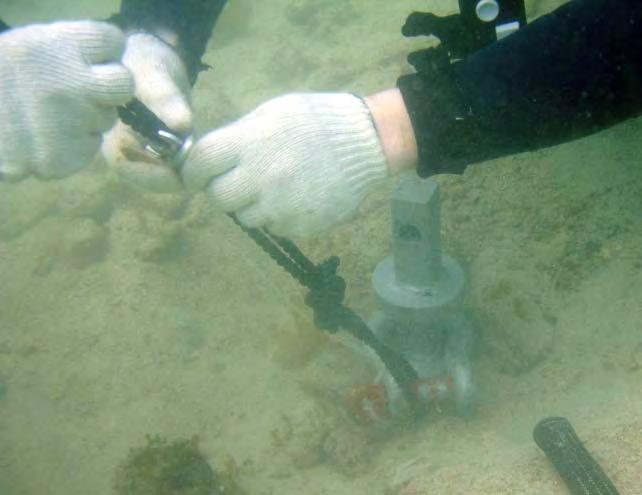
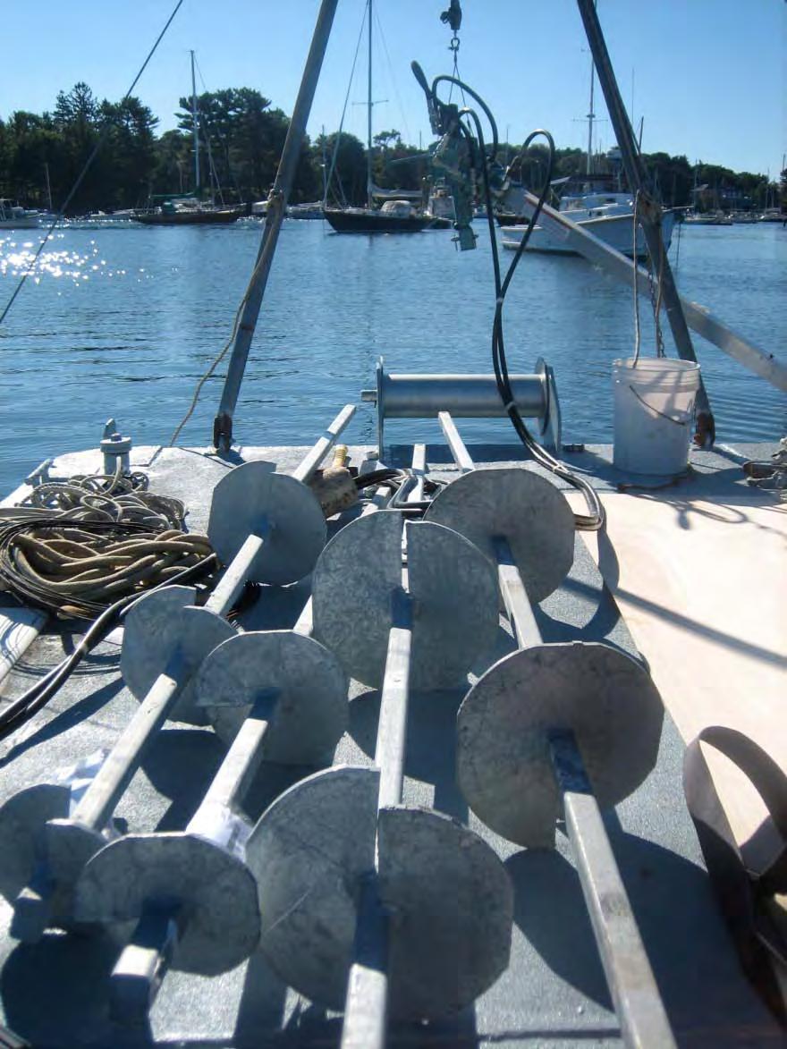
15 Does Technology Hold the Key? Conservation Moorings Chain is replaced with a floating elastic rode that provides play but eliminates contact with the substrate and eliminates scour Block is replaced with a helical anchor, which reduces the footprint from square meters to square centimeters Manufacturers claim Increased holding power Reduced maintenance costs Reduced wear and tear on vessels

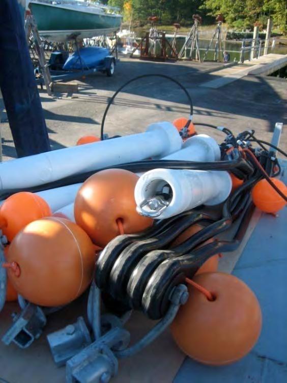
16 Royce Randlett Royce Randlett
17 Is it Legal to Site Mooring in Eelgrass Beds? Harbor masters have an exemption from the Army Corps of Engineers permitting process to place moorings, but this does not apply to eelgrass beds Private marinas must file for a Category 2 ACOE general permit for all mooring facilities ACOE requires mitigation for blocks and chains located within an eelgrass bed ACOE provides an escape route. If placed within a mooring scar, private boat owners can replace their traditional mooring with a conservation mooring under category 1 (non-reporting).
18 Objectives of Our Study 1) Assess the impact of conservation moorings (or lack of impact) on eelgrass beds in comparison to traditional moorings 2) Determine whether additional restoration activities (eelgrass transplants) are necessary for recolonization of mooring scars 3) Demonstrate the use of conservation moorings to boat owners, harbormasters and marina operators in Massachusetts 4) Make appropriate policy recommendations
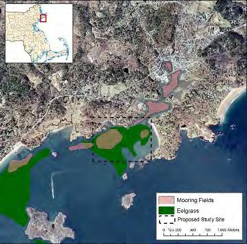
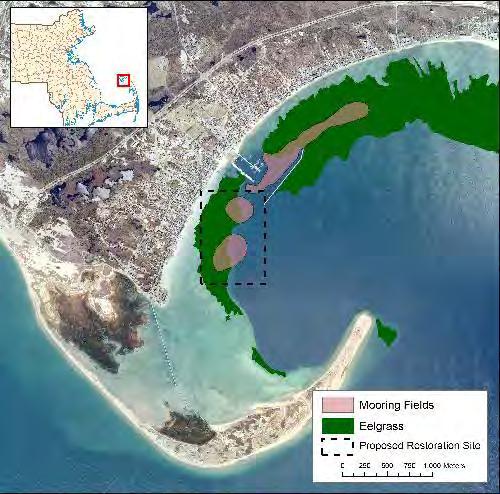
19 Methods 1) Replace 7 traditional moorings with conservation moorings in two distinct Massachusetts Harbors (Manchester and Provincetown) 2) Transplant eelgrass into a subset of the scars 3) Monitor the recovery 1) Diver surveys 2) Video transects 3) Water quality monitoring 4) Aerial photos 4) Document boater experience with the mooring systems
 d) Reference natural sand patch surrounded by eelgrass (1) e) Reference natural eelgrass meadow")
20 Treatments a) Traditional block and chain moorings and associated scars (3) b) Mooring scars with conservation moorings installed (3) c) Mooring scars with conservation moorings installed and eelgrass transplants (4) d) Reference natural sand patch surrounded by eelgrass (1) e) Reference natural eelgrass meadow (1)
.")
 Drop 12 random quadrats in reference")
21 Monitoring Diver Surveys (all ten moorings and sand patch) Establish transects in four cardinal directions (% cover, shoot density, canopy height). Includes measuring distanced to the edge of the bed (Transplanted scars) assess survival of transplanted shoots (Reference bed) Drop 12 random quadrats in reference bed measuring parameters listed above
 Periodic boater")
22 Monitoring Volunteer Monitoring Underwater video surveys Secchi disk Semiannual over-flights (LightHawk volunteer aviators) Periodic boater surveys
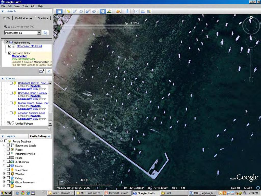
23 Preliminary Results Eight Conservation Moorings installed in Manchester-by-the-Sea Pre-restoration monitoring completed in Manchester Harbor October, 2010 Average diameter of mooring scars N-S = 6.6 m Average diameter of mooring scars E-W = 7.9 m Average area roughly 41 m 2 Going back to our estimate of 1872 moorings, mooring scars may account for 77,000 m2 of direct impacts
24

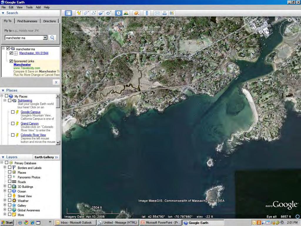
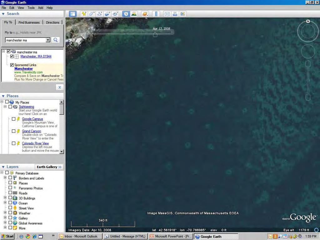
25 Time 0 Flyovers

26 Time 0 Flyovers
27 Considerations/Reflections Extremely difficult to get boat owners to participate in the program lack of faith in the newfangled technology liability concerns Permitting through the ACOE was a major hurdle Offer of free gear seemed to serve as little incentive for private boat owners Gear is expensive for private businesses I became a conservation mooring salesmen Monitoring needs to be kept relatively simple

28 Thanks to Our Funders! Association of National Estuary Programs / NOAA Community Based Restoration Partnership The Nature Conservancy
29 Thanks to Our Many Partners! Massachusetts Division of Marine Fisheries Environmental Protection Agency Town of Manchester Town of Provincetown Salem Sound Coastwatch Association to Preserve Cape Cod Provincetown Center for Coastal Studies LightHawk
Eelgrass Survey PARADISE CAY BELVEDERE, MARIN COUNTY CALIFORNIA. Prepared For:
 Eelgrass Survey PARADISE CAY BELVEDERE, MARIN COUNTY CALIFORNIA Prepared For: Radford (Skid) Hall, Ph.D. Land Planning and Permitting Consultant 500 Airport Blvd., Suite 350 Burlingame, CA 94010 (650)
Restoration of Eelgrass to Upper Casco Bay: Feasibility Tests in Hilary A. Neckles US Geological Survey Augusta, ME
 Restoration of Eelgrass to Upper Casco Bay: Feasibility Tests in 2015 Hilary A. Neckles US Geological Survey Augusta, ME hneckles@usgs.gov Robert J. Orth Eelgrass: Zostera marina * marine flowering plant
Eelgrass Survey Reporting Form 2222 Channel Road Newport Beach, CA Eelgrass (Zostera marina) Survey
 Survey") Eelgrass Survey Reporting Form 2222 Channel Road Newport Beach, CA 92660 Eelgrass (Zostera marina) Survey Survey Date: July 19th, 2013 Report Date: July 26 th, 2013 Prepared by: Coastal Resources Management,
Eelgrass Survey Reporting Form 2222 Channel Road Newport Beach, CA 92660 Eelgrass (Zostera marina) Survey Survey Date: July 19th, 2013 Report Date: July 26 th, 2013 Prepared by: Coastal Resources Management,
Conservation Mooring Study
 University of Massachusetts Boston ScholarWorks at UMass Boston Urban Harbors Institute Publications Urban Harbors Institute 1-1-2013 Conservation Mooring Study Urban Harbors Institute, University of Massachusetts
Seagrass surveys must be conducted between the dates of April 1 st and October 31 st with the following exceptions:
 Florida Fish and Wildlife Conservation Commission (FWC) Recommended Survey Protocols for Estuarine and Marine Submerged Aquatic Vegetation (SAV) related to Permitting Applications 12/14/2011 DRAFT 1) Survey
MAINTENANCE DREDGING IN A SENSITIVE ENVIRONMENT CASE STUDY: MANCHESTER ENTRANCE CHANNEL
 MAINTENANCE DREDGING IN A SENSITIVE ENVIRONMENT CASE STUDY: MANCHESTER ENTRANCE CHANNEL Carlos G. Peña, P.E. 1 ABSTRACT Eelgrass (Zostera marina) is a shallow water plant species common in coastal regions
Good Mooring to You! Jensen Beach Mooring Field. Kathy Fitzpatrick, P.E. Coastal Engineer, Martin County
 Good Mooring to You! Kathy Fitzpatrick, P.E. Coastal Engineer, Martin County Penny Cutt Regional Manager, Coastal Systems International Mooring Field Advantages Provide a safe and secure anchorage at a
Eelgrass and Macroalgae Presence/Absence Preliminary Surveys BHP Proposed Grays Harbor Potash Export Facility A Task 400
 Memorandum 40600-HS-MEM-55036 Revision 0 Date: 26 July 2018 Subject: Eelgrass and Macroalgae Presence/Absence Preliminary Surveys BHP Proposed Grays Harbor Potash Export Facility A17.0202.00 Task 400 INTRODUCTION
APPLICANT: Pacific Northwest National Laboratory Attention: Mr. Charles Brandt 1529 West Sequim Bay Road Sequim, Washington 98382
 US Army Corps of Engineers Seattle District Joint Public Notice Application for a Department of the Army Permit and a Washington Department of Ecology Water Quality Certification and/or Coastal Zone Management
N. Tay Evans Marine Fisheries Biologist & Technical Review Coordinator
 Massachusetts Division of Marine Fisheries Marine Fisheries Resource Recommendations: Time-of-Year Restrictions N. Tay Evans Marine Fisheries Biologist & Technical Review Coordinator Massachusetts Division
RESEARCH Massachusetts Recreational Boater Survey. Project Summary
 Coastal and Marine Spatial Planning RESEARCH Project Summary 2010 Massachusetts Recreational Boater Survey The 2010 Massachusetts Recreational Boater Survey gathered spatial and economic data relating
Essential Fish Habitat Description White hake (Urophycis tenuis)
") Description White hake (Urophycis tenuis) In its Report to Congress: Status of the Fisheries of the United States (September 1997), NMFS determined white hake is not currently overfished, but it is approaching
Description White hake (Urophycis tenuis) In its Report to Congress: Status of the Fisheries of the United States (September 1997), NMFS determined white hake is not currently overfished, but it is approaching
The Massachusetts Division of Marine Fisheries River Herring Count Summary Results. Prepared by: John Sheppard.
 The Massachusetts Division of Marine Fisheries 2012 River Herring Count Summary Results Prepared by: John Sheppard March 22, 2013 River herring have experienced declining populations across their native
Florida Seagrass Integrated Mapping and Monitoring Program
 Florida Seagrass Integrated Mapping and Monitoring Program - 2004 The following document is composed of excerpts taken from the 2011 publication, Seagrass Integrated Mapping and Monitoring for the State
Management of Shellfish Aquaculture and Propagation in Massachusetts Waters
 Management of Shellfish Aquaculture and Propagation in Massachusetts Waters Chris Schillaci Aquaculture and Propagation Project Massachusetts Division of Marine Fisheries Shellfish In Massachusetts Massachusetts
NOAA Fisheries Service (NMFS) Update on North Atlantic Right Whale Recovery Actions
 Update on North Atlantic Right Whale Recovery Actions") NOAA Fisheries Service (NMFS) Update on North Atlantic Right Whale Recovery Actions Asaro, M.J. 1 1 National Marine Fisheries Service, Greater Atlantic Regional Fisheries Office, 55 Great Republic Dr,
NOAA Fisheries Service (NMFS) Update on North Atlantic Right Whale Recovery Actions Asaro, M.J. 1 1 National Marine Fisheries Service, Greater Atlantic Regional Fisheries Office, 55 Great Republic Dr,
Coastal and marine recreation in New England is ingrained in the region s economic and
 RECREATION Coastal and marine recreation in New England is ingrained in the region s economic and social fabric. Recreation on the ocean and coast includes many of New Englanders most time-honored and
Red Bay Seagrass Bed recommendation to the Department of Environment Northern Ireland
 Seagrass Bed recommendation to the Department of Environment Northern Ireland Northern Ireland would recommend the large subtidal seagrass bed present in the Red Bay/Waterfoot Bay area of Co. Antrim (Fig.
Friends of Semiahmoo Bay Society Eelgrass Transplant Pilot Project May 6, 2007, Blackie Spit, Surrey, BC.
 Friends of Semiahmoo Bay Society Eelgrass Transplant Pilot Project May 6, 2007, Blackie Spit, Surrey, BC. Prepared for: Friends of Semiahmoo Bay Society Prepared by: Ramona C. de Graaf, BSc., MSc., Emerald
Orange County MPA Watch A n n u a l R e p o r t
 Orange County MPA Watch 2 0 1 4 A n n u a l R e p o r t WHAT IS AN MPA? Marine Protected Areas (MPAs) are discrete geographic marine or estuarine areas designed to protect or conserve marine life and habitat.
Oceanic Society Reef Research Team: Nicole Crane, Avigdor Abelson, Peter Nelson, Giacomo Bernardi, Michelle Paddack, Kate Crosman
 The coral reef of Tamil (Yap, FSM): Preliminary ecological assessment of reef state and fish assemblages, and potential of conservation for sustainable use Report compiled by vigdor belson, Peter Nelson
City of Pittsfield HARBORMASTER RULES AND REGULATIONS on docks
 City of Pittsfield HARBORMASTER RULES AND REGULATIONS on docks Definitions Dock: Any permanently fixed or floating structure extending from the upland into the water, capable of use for vessel mooring
SOCIETAL GOALS TO DETERMINE ECOSYSTEM HEALTH: A FISHERIES CASE STUDY IN GALVESTON BAY SYSTEM, TEXAS
 SOCIETAL GOALS TO DETERMINE ECOSYSTEM HEALTH: A FISHERIES CASE STUDY IN GALVESTON BAY SYSTEM, TEXAS Anthony S. Pait, NOAA, National Centers for Coastal Ocean Science Thomas P. O Connor, David R. Whitall,
30 DAY PUBLIC NOTICE MAINTENANCE DREDGING OF THE 8-FOOT CHANNEL OF THE FEDERAL NAVIGATION PROJECT IN KENNEBUNK RIVER KENNEBUNK & KENNEBUNKPORT, ME
 fr.iiif.i ~ US Anny Corps of Engineers New England District 696 Virginia Road Concord, MA 01742-2751 Public Notice In Reply Refer to: Mr. Jack Karalius nae-pn-nav@usace.army.mil Programs/Project Management
Essential Fish Habitat Description Atlantic cod (Gadus morhua)
") Description Atlantic cod (Gadus morhua) In its Report to Congress: Status of the Fisheries of the United States (September 1997), NMFS determined the Gulf of Maine stock of cod is considered overfished,
Description Atlantic cod (Gadus morhua) In its Report to Congress: Status of the Fisheries of the United States (September 1997), NMFS determined the Gulf of Maine stock of cod is considered overfished,
Fishing for Energy Fund Project Summaries
 Fishing for Energy Fund Project Summaries Removal of 'ghost' blue crab pots from known hotspots in VA, College of William and Mary, Virginia Institute of Marine Science Virginia Fishing for Energy Fund
Final Waterways Assets and Resources Survey Master Plan for Dredging and Beach Nourishment
 Final Waterways Assets and Resources Survey Master Plan for Dredging and Beach Nourishment For, Massachusetts Prepared For: Dennis Town Hall P.O. Box 2060 485 Main Street Dennis, MA 02660 Prepared By:
Skate Amendment 3 Scoping Hearings Staff summary of comments May 22-24, 2007
 Skate Amendment 3 Scoping Hearings Staff summary of comments May 22-24, 2007 The hearings were sparsely attended, the highest turnout was in Narragansett, RI by a processor and several fishermen that target
How many adult oysters are in the Great Bay Estuary and how has it changed over time?
 Indicator: in the Great Bay Estuary Question How many adult oysters are in the Great Bay Estuary and how has it changed over time? Short Answer The number of adult oysters decreased from over 25 million
City of Pittsfield Harbormaster APPLICATION FOR AN INDIVIDUAL MOORING PERMIT
 City of Pittsfield Harbormaster APPLICATION FOR AN INDIVIDUAL MOORING PERMIT INSTRUCTIONS: This application may only be used for requests to place lake moorings. This application must be completed in its
SEAGRASS MAPPING FOR THE PENRHYN ESTUARY HABITAT ENHANCEMENT PLAN
 SEAGRASS MAPPING FOR THE PENRHYN ESTUARY HABITAT ENHANCEMENT PLAN PREPARED FOR SYDNEY PORTS CORPORATION By D. E. Roberts, S. R. Murray, G. R., Sainty August 2008 TABLE OF CONTENTS INTRODUCTION...3 METHODS...3
Essential Fish Habitat Description Atlantic herring (Clupea harengus)
") Description Atlantic herring (Clupea harengus) In its Report to Congress: Status of the Fisheries of the United States (September 1997), NMFS determined Atlantic herring is not currently overfished. This
Description Atlantic herring (Clupea harengus) In its Report to Congress: Status of the Fisheries of the United States (September 1997), NMFS determined Atlantic herring is not currently overfished. This
Building Coastal Resiliency at Plymouth Long Beach
 Building Coastal Resiliency at Plymouth Long Beach Department of Marine and Environmental Affairs March 30, 2017 Introducing Green Infrastructure for Coastal Resiliency Plymouth Long Beach & Warren s Cove
Essential Fish Habitat OCNMS Advisory Council July 13, 2013
 Essential Fish Habitat OCNMS Advisory Council July 13, 2013 John Stadler Habitat Conservation Division NMFS Northwest Region Essential Fish Habitat (EFH) What is it, where did it come from, and what does
Nearshore Habitat Mapping in Puget Sound Using Side Scan Sonar and Underwater Video
 Nearshore Habitat Mapping in Puget Sound Using Side Scan Sonar and Underwater Video Dana Woodruff, Paul Farley, Amy Borde, John Southard, Ron Thom Battelle Marine Sciences Laboratory Jim Norris Marine
Merepoint Boat Launch Facility Eelgrass Mitigation Measures: 2012 Monitoring Report
 : Prepared for Department of Inland Fisheries and Wildlife 284 State Street Augusta, ME 04333-0041 207-287-8000 by MER Assessment Corporation 14 Industrial Parkway Brunswick, Maine 04011 207-798-7935 (V)
RACHEL COLE National Marine Aquarium, Plymouth
 CITIZEN SCIENCE FOR SEAGRASS IN THE SOUTH WEST: THE COMMUNITY SEAGRASS INITIATIVE RACHEL COLE National Marine Aquarium, Plymouth Seagrasses create important marine habitats for many species and provide
TOWN OF DENNIS 10 YR COMPREHENSIVE DREDGE PERMIT SEPTEMBER 10, 2013
 TOWN OF DENNIS 10 YR COMPREHENSIVE DREDGE PERMIT SEPTEMBER 10, 2013 WHAT IS IT? ALL NECESSARY PERMITS FOR DREDGING FOR PORTIONS OF BASS RIVER, SWAN POND RIVER, SESUIT HARBOR AND CHASE GARDEN CREEK ONE
Determining coral reef impacts associated with boat anchoring and user activity
 Determining coral reef impacts associated with boat anchoring and user activity Protect Our Reefs Grant Interim Report October 1, 2008 March 31, 2009 Donald C. Behringer 1, Thomas K. Frazer 1, Robert A.
Longshore Bar Creation: a viable option for seagrass restoration?
 Longshore Bar Creation: a viable option for seagrass restoration? Lindsay M. Cross, Tampa Bay Estuary Program Holly Greening, Tampa Bay Estuary Program Michael Seifert, Tampa Port Authority Susan Burtnett,
SACO RIVER AND CAMP ELLIS BEACH SACO, MAINE SECTION 111 SHORE DAMAGE MITIGATION PROJECT APPENDIX F ECONOMIC ASSESSMENT
 SACO RIVER AND CAMP ELLIS BEACH SACO, MAINE SECTION 111 SHORE DAMAGE MITIGATION PROJECT APPENDIX F ECONOMIC ASSESSMENT Department of the Army New England District, Corps of Engineers 696 Virginia Road
Storm Preparedness Plan for Manchester, Massachusetts Issued by the Manchester Harbormaster Department. A.
 Manchester-by-the-Sea Harbormaster Harbormaster 10 CENTRAL ST. MANCHESTER, MASSACHUSETTS 01944-1399 OFFICE (978)526-7832 CELL (978)473-2520 FAX (978)526-2001 HARBORMASTER@MANCHESTER.MA.US. Storm Preparedness
Can we minimize the impact of vessel moorings on coastal habitats? An interagency management approach in Queensland
 Can we minimize the impact of vessel moorings on coastal habitats? An interagency management approach in Queensland Kurt Derbyshire 1, Rebecca Batton 1, Nicola Udy 2, Kimberly Foster 3 and Richard Marsh
LEARNING FROM SANDY Webinar 3. Lessons learned. March 26, Beth A. Leonard Director of Technical Services BoatU.S.
 LEARNING FROM SANDY Webinar 3 Lessons learned March 26, 2013 Beth A. Leonard Director of Technical Services BoatU.S. BoatU.S. Catastrophe (CAT) Teams First deployed after Hurricane Alicia hit Houston in
Orange County MPA Watch M o n i t o r i n g H u m a n U s a g e
 Orange County MPA Watch M o n i t o r i n g H u m a n U s a g e WHAT IS AN MPA? Marine Protected Areas (MPAs) are discrete geographic marine or estuarine areas designed to protect or conserve marine life
Managing Chesapeake Bay s Land Use, Fish Habitat, and Fisheries: Studies. Jim Uphoff & Margaret McGinty, Fisheries Service
 Managing Chesapeake Bay s Land Use, Fish Habitat, and Fisheries: Positive Image and or Negative Graphic Case Studies Jim Uphoff & Margaret McGinty, Fisheries Service Maryland Fisheries Service has been
Eastern Shore Islands Area of Interest Community Newsletter
 Eastern Shore Islands Area of Interest Community Newsletter Fall 2018 1ỊNTRODUCTION In addition to information on our Fisheries and Oceans Canada (DFO) website, we have now created a seasonal, community
Orange County MPA Watch A n n u a l R e p o r t
 Orange County MPA Watch 2 0 1 5 A n n u a l R e p o r t WHAT IS AN MPA? Marine Protected Areas (MPAs) are discrete geographic marine or estuarine areas designed to protect or conserve marine life and habitat.
Video-Based Mapping of Oyster Bottom in the Upper Piscataqua River, Sturgeon Creek, and Spruce Creek
 University of New Hampshire University of New Hampshire Scholars' Repository PREP Reports & Publications Institute for the Study of Earth, Oceans, and Space (EOS) 1-21-2009 Video-Based Mapping of Oyster
Cat Island Chain Restoration
 Cat Island Chain Restoration 1820s Fox River Military Road Map to Fort Howard 1845 Chart of Green Bay & Fox River Cat Island Chain - 1938 Cat Island Brown County Aerial Photography, 1938 Historic Western
Puget Sound Shorelines. Waves and coastal processes. Puget Sound shorelines: Effects of beach armoring
 Puget Sound Shorelines Puget Sound shorelines: Effects of beach armoring Waves and coastal processes Factors affecting wave energy hitting the coast Processes transporting sediment along coastlines What
Summary Report for Sarasota Bay
 Summary Report for Sarasota Bay Contacts: Jay Leverone, Sarasota Bay Estuary Program Jon Perry and Rene Janneman, Sarasota County Greg Blanchard, Manatee County Kristen Kaufman, Southwest Florida Water
Chapter I: Marine Resources
 NOTE TO READERS: This is a draft of the Kennebunk Comprehensive Plan. The Comprehensive Plan provides us with a description of the town today in a range of categories, and identifies issues and recommendations
Spatial/Seasonal overlap between the midwater trawl herring fishery and predator focused user groups
 Spatial/Seasonal overlap between the midwater trawl herring fishery and predator focused user groups A working paper submitted to the Herring PDT Micah Dean July 26, 2017 Introduction A goal of Amendment
Fine-Scale Survey of Right and Humpback Whale Prey Abundance and Distribution
 DISTRIBUTION STATEMENT A. Approved for public release; distribution is unlimited. Fine-Scale Survey of Right and Humpback Whale Prey Abundance and Distribution Joseph D. Warren School of Marine and Atmospheric
STATE OF MAINE DEPARTMENT OF MARINE RESOURCES
 STATE OF MAINE DEPARTMENT OF MARINE RESOURCES IN THE MATTER OF THE APPLICATION OF GREAT ) EASTERN MUSSEL FARMS FOR AN AQUACULTURE ) FINDINGS OF FACT, LEASE LOCATED OFF OF HADLEY POINT IN THE ) CONCLUSIONS
New York District Briefing Template
 New York District Briefing Template New York District US Army Corps of Engineers Insert Text Here Dredging Windows Workshop November 30, 2011 Aquatic Biological Survey Winter Flounder Jenine Gallo & Kate
UPPER BEACH REPLENISHMENT PROJECT RELATED
 ASSESSMENT OF SAND VOLUME LOSS at the TOWNSHIP of UPPER BEACH REPLENISHMENT PROJECT RELATED to the LANDFALL OF HURRICANE SANDY - PURSUANT TO NJ-DR 4086 This assessment is in response to Hurricane Sandy
Green crabs: invaders in the Great Marsh Featured scientist: Alyssa Novak from the Center for Coastal Studies/Boston University
 Name Green crabs: invaders in the Great Marsh Featured scientist: Alyssa Novak from the Center for Coastal Studies/Boston University Research Background: Marshes are areas along the coast that flood with
Public Notice U.S. Army Corps In Reply to Application Number CENAB-OP-RMS (NATIONAL HARBOR (FORMERLY PORT Baltimore District AMERICA])
![Public Notice U.S. Army Corps In Reply to Application Number CENAB-OP-RMS (NATIONAL HARBOR (FORMERLY PORT Baltimore District AMERICA])](/thumbs/89/100795623.jpg "Public Notice U.S. Army Corps In Reply to Application Number CENAB-OP-RMS (NATIONAL HARBOR (FORMERLY PORT Baltimore District AMERICA])") Public Notice U.S. Army Corps In Reply to Application Number of Engineers CENAB-OP-RMS (NATIONAL HARBOR (FORMERLY PORT Baltimore District AMERICA]) 88-01361 PN 14-05 Comment Period: January 16, 2014 to
Public Notice U.S. Army Corps In Reply to Application Number of Engineers CENAB-OP-RMS (NATIONAL HARBOR (FORMERLY PORT Baltimore District AMERICA]) 88-01361 PN 14-05 Comment Period: January 16, 2014 to
Comparative growth of pinfish in field mesocosms across marsh, oyster, and soft-bottom habitat types in a Mississippi estuary
 Comparative growth of pinfish in field mesocosms across marsh, oyster, and soft-bottom habitat types in a Mississippi estuary Virginia Shervette and Fran Gelwick Department of Wildlife and Fisheries Sciences
Keywords: marine habitat recovery, derelict fishing gear
 Marine habitat recovery after derelict fishing net removal. Jeff June*, Kyle Antonelis, Natural Resources Consultants, Inc. Seattle, WA. *Corresponding author: jjune@nrccorp.com Keywords: marine habitat
Habitat Fact Sheets. Rocky habitats are dominated by seaweeds and often mussels, which rely on the rocks for attachment.
 Habitat Fact Sheets Habitats in the Gulf of Maine serve many important roles for the environment and for humans as well. These include: cycling nutrients, filtering pollution, trapping sediments, storing
BAYKEEPER. Utilizing Volunteers in Baykeeper s Oyster Restoration Program
 NY/NJ BAYKEEPER Utilizing Volunteers in Baykeeper s Oyster Restoration Program Meredith Comi, Oyster Restoration Program Director Hooked on our Waters October 19, 2013 Baykeeper s Mission PROTECT, PRESERVE,
Expanding Anchoring Away
 Expanding Anchoring Away Vessel taxonomy &territorial waters Maritime and admiralty law distinguished The right to navigate Federal navigational servitude as applied CZMA, reverse federalism & Florida
Case Study 3. Case Study 3: Cebu Island, Philippines MPA Network 10
 Case studies of mpa networks Case Study 3: Cebu Island, Philippines MPA Network 10 Location and background Cebu Island in the Philippines lies in the center of the Visayan Islands, known as an area high
Project Webpage:
 Project Webpage: http://nature.ly/marinesatlanticbightera Coastal Data and Full Metadata: http://easterndivision.s3.amazonaws.com/marine/sab MA/SABMACoastalEcosystems.zip Coastal Chapter: http://easterndivision.s3.amazonaws.com/marine/sab
Changes in dominant species of seagrass bed off Iwakuni, Seto Inland Sea, Japan
 Changes in dominant species of seagrass bed off Iwakuni, Seto Inland Sea, Japan Kenji SUGIMOTO, Yorihide ASAOKA Toshinobu TERAWAKI and Mitsumasa OKADA Background 1 Seagrass Highly productive components
Seagrass Surveys in Kampot
 Coastal Annual Forum 23 rd October 2014 Sihanoukville, Cambodia Seagrass Surveys in Kampot Presentation by Louis Bourne INTERNATIONAL UNION FOR CONSERVATION OF NATURE Presentation Overview Location and
Essential Fish Habitat
 Pacific Fishery Management Council Fact sheet: Essential Fish Habitat Habitat is the environment where an animal lives, feeds, and reproduces. Identifying fish habitat is complex because fish move through
COMMERCIAL & RECREATIONAL FISHING
 COMMERCIAL & RECREATIONAL FISHING Commercial fishing in New England has a long and storied history. Its importance culturally and economically has lasted hundreds of years, becoming a part of many tales
Coastal Wetlands Protection Act. Fisheries Management, Marine Sanctuaries and Closures
 , STATE AND LOCAL AUTHORITY FOR MARINE PROTECTION (2014). MISSISSIPPI 1 State Authority for Protection Summary of State Authorities Mississippi has several options for conserving marine habitat; however,
 Page 1 of 6 Nav-Aid Basics Unlike the roads and highways that we drive on, the waterways we go boating on do not have road signs that tell us our location, the route or distance to a destination, or of
APPENDIX A AGENCY COORDINATION
 APPENDIX A AGENCY COORDINATION Page left blank intentionally Paul J. Diodati Director August 25, 2010 Commonwealth of Massachusetts Division of Marine Fisheries Annisquam River Marine Fisheries Station
Underwater Videographic and Hydroacoustic Eelgrass Survey Chimacum/Irondale Beach Restoration Site September 12, 2006
 Underwater Videographic and Hydroacoustic Survey Chimacum/Irondale Beach Restoration Site September 12, 2006 by James G. Norris and Ian E. Fraser Submitted To: North Olympic Salmon Coalition PO Box 699
LAKE JESUP VEGETATION MAPPING: AN INTER-AGENCY COLLABORATION. Lakshmi Sankaran, GISP Public Works Department, Seminole County
 LAKE JESUP VEGETATION MAPPING: AN INTER-AGENCY COLLABORATION Lakshmi Sankaran, GISP Public Works Department, Seminole County LAKE JESUP Area - 12 sq miles Shoreline - 53 miles Watershed - 136 sq miles
Significant Ecological Marine Area Assessment Sheet
 Significant Ecological arine Area Assessment Sheet Name: ouhora arbour arine Values Summary: The entrance subtidal channel, tidal flats, seagrass mangrove and saltmarsh habitats of ouhora arbour have given
Thanks to: -Current and former Habitat staff -Fish Program Marine Fish Division & Region 6 Staff
 Thanks to: -Current and former Habitat staff -Fish Program Marine Fish Division & Region 6 Staff - Overview Intro to forage fish What they are and why are they important Nearshore Forage Fish Habitat surveys
National Marine Fisheries Service, Habitat Conservation Division:
 National Marine Fisheries Service, Habitat Conservation Division: Essential Fish Habitat, South East Florida Coral Reef Initiative and Land- Based Sources of Pollution effects on Critical Fisheries Habitats
Saco River Maintenance Dredge PROJECT PLAN AND TIMELINE JUNE 15, 2017
 Saco River Maintenance Dredge 2017-2018 PROJECT PLAN AND TIMELINE JUNE 15, 2017 Overview Last dredged in 1994 Removing ~150,000 cy of sand and silt from the upper and lower reaches Disposal sites: In-River
Comparison of Acoustic and Aerial Photographic Methods for Quantifying the Distribution of Submersed Aquatic Vegetation in Sagamore Creek, NH
 Comparison of Acoustic and Aerial Photographic Methods for Quantifying the Distribution of Submersed Aquatic Vegetation in Sagamore Creek, NH by Bruce Sabol, Elizabeth Lord, Kevin Reine, and Deborah Shafer
Living Shorelines: Considerations for Advancing Coastal Resiliency
 Living Shorelines: Considerations for Advancing Coastal Resiliency Elaine Mahoney 1, James Turek 2, Janine Harris 3, and Karen Greene 4 1 NOAA Coastal Services Center, NY 2 NOAA Restoration Center, Narragansett,
An Introduction To Marine Charts
 An Introduction To Marine Charts //captnmike.com Revised August 29, 2011 An Illustrated introduction to U. S. Aids to Navigation in the Shilshole Bay area of Puget Sound, Washington. The chart symbols
Biogeographic Assessment of Florida Keys National Marine Sanctuary
 Biogeographic Assessment of Florida Keys National Marine Sanctuary NOAA National Centers for Coastal Ocean Science NOAA Florida Keys National Marine Sanctuary Florida Fish and Wildlife Commission Photos
NOAA s Role in Chesapeake Bay
 NOAA s Role in Chesapeake Bay NOAA Chesapeake Bay Office Mission To understand, predict and explain changes in the Chesapeake Bay ecosystem, and to coordinate efforts to conserve and manage coastal and
The Blue Heron Slough Conservation Bank
 1 The Blue Heron Slough Conservation Bank CONSERVATION BANKING July 19-23, 2010 CASE STUDY SERIES The Blue Heron Slough Conservation Bank (Washington) I. OVERVIEW & BACKGROUND: Location: Snohomish River
SECTION II NM 18/16 NAVIGATION PUBLICATIONS SAILING DIRECTIONS CORRECTIONS. provide calving area functions in Unit 2, are: (2743)
") NAVIGATION PUBLICATIONS SAILING DIRECTIONS CORRECTIONS PUB 146 16 Ed 2014 LAST NM 12/15 Pub. 146 has been updated to 26 March 2016, including Notice to Mariners 13/2016, and can be downloaded from the
NAVIGATION PUBLICATIONS SAILING DIRECTIONS CORRECTIONS PUB 146 16 Ed 2014 LAST NM 12/15 Pub. 146 has been updated to 26 March 2016, including Notice to Mariners 13/2016, and can be downloaded from the
Nicholas Brown. 31 Bennett Rd Wolfeboro NH Application submitted
 Nicholas Brown 31 Bennett Rd Wolfeboro NH 03894 603-856-5454 Nick4634@gmail.com Application submitted 8-12-2017 Description of proposed project A. General Methodology The site located approximately 600
Quantitative Freshwater Mussel Survey Date Prepared: 11/20/2017
 PARTNERSHIP FOR THE DELAWARE ESTUARY Science Group Quantitative Freshwater Mussel Survey Date Prepared: 11/20/2017 Prepared By: Kurt Cheng Suggested Citation: Cheng, K. 2017. Quantitative Freshwater Mussel
Time Will Tell: Long-term Observations of the Response of Rocky-Habitat Fishes to Marine Reserves in Puget Sound
 Time Will Tell: Long-term Observations of the Response of Rocky-Habitat Fishes to Marine Reserves in Puget Sound Wayne A. Palsson, Robert E. Pacunski, and Tony R. Parra Washington Department of Fish and
Managing Development and Chesapeake Bay s Estuarine Fish
 Managing Development and Chesapeake Bay s Estuarine Fish Habitat Image and or Graphic Fisheries James H. Uphoff Jr. and Margaret M. McGinty Maryland Fisheries Service Funded through USFWS Federal Aid Maryland
New Jersey Coastal Zone Overview. The New Jersey Beach Profile Network (NJBPN) 3 Dimensional Assessments. Quantifying Shoreline Migration
 3 Dimensional Assessments. Quantifying Shoreline Migration") New Jersey Coastal Zone Overview The New Jersey Beach Profile Network (NJBPN) Objectives Profile Locations Data Collection Analyzing NJBPN Data Examples 3 Dimensional Assessments Methodology Examples Quantifying
New Jersey Coastal Zone Overview The New Jersey Beach Profile Network (NJBPN) Objectives Profile Locations Data Collection Analyzing NJBPN Data Examples 3 Dimensional Assessments Methodology Examples Quantifying
Impacts of breakwaters and training walls
 Across the eastern seaboard of Australia, breakwaters and training walls have instigated fundamental perturbations to coastal and estuary processes. This has induced long-term changes to foreshore alignments,
Review of the current impacts of Dredge Spoil Islands and water circulation on adjacent seagrass beds Swansea Flats
 Office of the Lake Macquarie and Catchment Co-ordinator Review of the current impacts of Dredge Spoil Islands and water circulation on adjacent seagrass beds Swansea Flats March 2004 TABLE OF CONTENTS
11426 Moorage Way P.O. Box 368 LaConner, WA Phone: Fax:
 Skagit River System Cooperative 11426 Moorage Way P.O. Box 368 LaConner, WA 98257-368 Phone: 36-466-7228 Fax: 36-466-447 www.skagitcoop.org BULL TROUT USE OF SWINOMISH RESERVATION WATERS Eric Beamer, Rich
Derelict crab trap removal and prevention in southern New Jersey coastal bays: big implications for smaller scale systems
 Derelict crab trap removal and prevention in southern New Jersey coastal bays: big implications for smaller scale systems Principal investigators: Mark Sullivan, Steve Evert, Pete Straub, Melanie Reding,
Repeat Monitoring of Seagrass Beds for Project Next Generation Autumn 2016
 Repeat Monitoring of Seagrass Beds for Project Next Generation Autumn 2016 Prepared by April 2016 Project Next Generation: Repeat Seagrass Monitoring: Autumn 2016 1 Repeat Monitoring of Seagrass Beds for
Comments to The Clinton Shellfish Commission Winter 2007 Meeting Discussion Tuesday, January 9, 2007 Timothy C. Visel
 Comments to The Clinton Shellfish Commission Winter 2007 Meeting Discussion Tuesday, January 9, 2007 Timothy C. Visel Restoration or Mitigation of Navigational Dredging Projects Hammonassett Natural Oyster
PLANNING TO KEEP WELLFLEET SPECIAL
 PLANNING TO KEEP WELLFLEET SPECIAL HEATHER MCELROY Wellfleet Conservation Trust Annual Meeting : August 18, 2018 Mission of the Cape Cod Commission To protect the unique values and quality of life on Cape