23/06/14 Pungarehu 1
|
|
|
- Corey Pierce
- 5 years ago
- Views:
Transcription

1 23/06/14 Pungarehu 1


2 Longfin in the wild Longfin ready for the heke 2
3 GOAL: Revitalise traditional fishing practices of Whanganui Iwi OBJECTIVES 1. To assess the state of traditional fisheries and supporting habitat 2. To identify traditional fisheries management used by Whanganui Iwi 3. Complete a research report to inform management decisions affecting our taonga METHODS Iden%fica%on of taonga species, fishing prac%ces and suppor%ng habitat A review of all available literature including submissions and reports was completed. Taonga species, fishing prac?ces and suppor?ng habitat were iden?fied 3
 Poha (nets), pah (stone pa) River and estuary")
4 Species of tradi?onal significance in marine and freshwater environments Taonga species Main tradi5onal fishing prac5ce Aqua5c environment and habitat Inanga (whitebait) Poha (nets), pah (stone pa) River and estuary ripo (rapids), river bank, gravel Koaro (whitebait) Poha, pah River and estuary ripo, river bank, gravel Banded, short- jawed, & giant kokopu (whitebait) Poha, pah River and estuary ripo, river bank, gravel Ngaore (common smelt) Poha, pah River and estuary ripo, river bank, gravel Papanoko (torrenoish) Poha, pah River and estuary ripo, river bank, gravel Toitoi (upland, common, redfin, and Cran s bully) Poha, pah River and estuary ripo, river bank, gravel Karohi (whitebait) Poha, pah River and estuary ripo, river bank, gravel Pariri Bobbing (s?ck with worm) River and estuary ripo Kakahi (freshwater mussel) Rukukai (hand gathering) River mud and sand banks Koura (tau koura = freshwater täruke = saltwater) Freshwater crayfish=tau koura (using rahurahu fern), Saltwater crayfish=taaruke Tau koura=river and tributaries kakahi beds Taaruke=Rohe moana reefs Piharau (lamprey) Utu piharau (weir) River - Ripo Tuna (longfin and shoroin eel) Paa auroa/paa tuna, hïnaki, bobbing, rama matarau (torch & spear), Aho hii ika matau River, lakes, tributaries Ripo, driuwood/ snags along the river bank, deep pools (hook & line), harakeke rope Pa5ki (flaoish) Poha, rama matarau River and estuary mudflats and sandy inter5dal/sub5dal areas Kanae (grey and yellow- Poha River and estuary eyed mullet) Kahawai Poha, Aho hii ika matau River and estuary 4
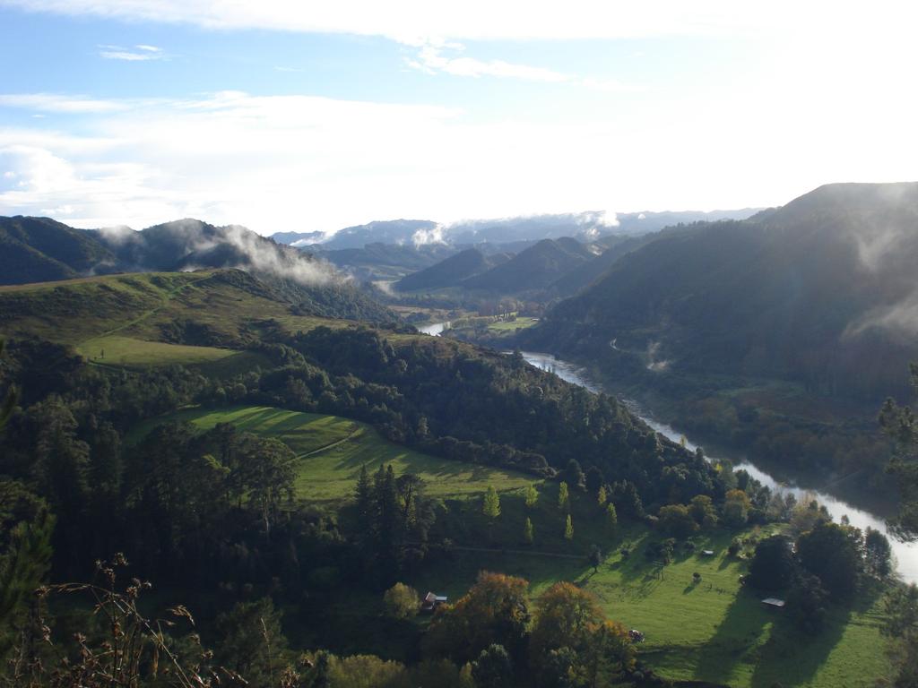
5 Rapid name: Upokopoito Site number: 1 Approximate distance from river mouth: 43km Site photo Topography Stored in WRMTB database High cliffs on the both sides of the river papa cliffs run along the length of the rapid. Right bank is gradual slope flavens out to farmland; stock can access awa. A large gravel bank forms an island at this site: - a man- made wall lies at the top end of the ley side of the island - two man- made walls lie at the bovom of the island The main channel is to the right of the gravel island Depth Profile Water flow Water clarity Water level: Low=L, Mid=M, High=H Site accessibility Substratum State of river bank Shallow around the island, deepens towards river banks. Deepest in middle of both channels Fast flowing current Water ranged from opaque colour in centre of channels through to clear water in the shallows Very low compared to the average water level Requires a boat to access this site Gravel, sand and silt. DriYwood and large logs lie along the steep papa cliff side of the river and run the length of the rapid up to a kilometre downstream to Te Auokura rapid Mainly willow and poplar trees around the edges of the river bank with some na?ve plants scavered throughout the area. Pasture extends to the riverbank in places up and downstream of the site. There is obvious visual evidence that erosion affects this site. Goats and pigs were observed grazing the steep papa cliff side. CaVle also have access to the river up and downstream where the steep sided bank slopes away to hill country terrain Rapid name: Te Auokura Site number: 2 Approximate distance from river mouth: 42km Site photo Stored in WRMTB database Topography Steep sided bank slopes away to undula?ng hill country on one side of the river. On the other side a road follows the river cubng through steep hill country. Depth Profile Deep from river bank to river bank Water flow Fast flowing current in the middle of the river a result of man- made walls that channel the water Water clarity Predominantly clear water on the inside of the man- made walls, through to opaque in the middle (deepest sec?on) Water level Very low compared to the average water level Site accessibility This site is difficult to access by land, having to nego?ate down a steep bank covered in na?ve bush Substratum Gravel, sand and silt. DriYwood and logs are stranded in a large back current from one river bank out to approximately 20 metres into the river and extend about 250 metres downstream State of river bank Sand/silt river bank transi?ons from steep grassy banks to regenera?ng na?ve shrub. Some pasture on one side above the high river bank. Very livle visual evidence that erosion affects this site. 5
6 Rapid name: Whakaruawaka Site number: 4 Approximate distance from river mouth: 38km Site photo Stored in WRMTB database Topography Gradual inclines on both sides of the river that rise steeply Depth Profile A deep groyne runs for 500m upstream of the rapid. The depth profile gets shallow across the rapid and deepens downstream of the rapid Water flow Fast flowing current Water clarity Clear in the back current (eddy), opaque where the current is swiy Water level Very low compared to the average water level Site accessibility Access from road side Substratum Gravel, sand and silt. This site has a large gravel bed (approx 1.5 acres). DriYwood and logs occur along both river banks. State of river bank Pasture on one side and large poplar trees & willow trees on the other side. Erosion of the river bank is evident at this site CaVle were observed grazing the river bank. Rapid name: : Paetawa Site number: 5 Approximate distance from river mouth: 36km Site photo Stored in WRMTB database Topography Steep river banks drop ver?cally for approximately 10m before mee?ng the waters edge. Depth Profile Shallow on one side of the gravel bed (island during low water levels) and deep on the other side Water flow Fast flowing current on the deep side of the island and slower flowing current in the shallow region Water clarity Clear in the shallows, opaque in deep water Water level Very low compared to the average water level Site accessibility Access through private property and down the steep sided river bank Substratum There was a large kakahi bed between the rapids - vital koura habitat. Manmade rock wall is present at this site. Submerged snags occur along both sides of the river for a distance of approximately 2kms downstream. State of river bank Both banks have patches of regenera?ng na?ve bush, large poplar & willow trees. Farmland extends to the steep sided river bank in areas. Erosion of the river bank is evident at this site CaVle were observed grazing the river bank. 6
7 CONCLUSION Tragically, large tuna are no longer in abundance because the rhythm of annual ebb and flow of tuna in the River has been altered by water diversions, pollu?on, habitat degrada?on and unsustainable levels of commercial fishing, farming This pilot study highlights some key observa?ons: Large numbers of healthy tuna that were caught throughout the year using many different methods (catches regularly exceeded 2000 tuna in a single night) no longer happens Catch rates have been reduced to a frac?on of past levels, eroding the primary food supply of whänau and hapu of the Whanganui River. 7
8 tradi?onal sites have been eliminated through erosion. Erosion is magnified during flood events because farmers and?mber merchants have removed large na?ve trees along the River, reducing the stability of the papa riverbank Large tuna (over 4kg) used to be common. Current catches indicate this is no longer the case. Therefore, the observed decline in size and number of tuna within our mahinga kai may be due to a combination of anthropogenic effects, such as: The Whanganui River no longer flows to the same rhythm because hydro-power schemes have diverted the flow of water at 18 locations on the River in order to generate renewable sustainable power. The obvious impacts of the diversions are: obstruction to the downstream migration of adult tuna (reducing breeding capacity) obstruction to the upstream migration of juvenile tuna (limiting recruitment to areas below diversions) reduction in the amount of water in the River at any given time (increasing mortality during summer months when water levels are naturally low) 8
9 Erosion, a result of significant deforestation along parts of the River to provide for agriculture and forestry, reduces water quality and alters preferred tuna habitat. Erosion may also have an adverse effect on potential food sources of tuna. Pollution and destruction of habitat from gravel mining operations and agricultural development may have an adverse effect on the health of tuna as well as impacting potential food sources of tuna. Introduced exotic species like trout compete for the preferred food source of tuna Commercial fishing has reduced the number and size of tuna, and still continues in the lower reaches of the Whanganui River Enormous gravel banks once snaked along the River, changing shape with each new flood event, providing essen?al habitat for tuna and prey alike large boulders made up a significant propor?on of these large gravel banks. Flow- rates altered by hydro- power scheme diversions introduced post 1960 reduce the effect flood events have on moving and reshaping gravel beds in the River. 9
10 The removal of river stone and boulders has reduced vital tuna habitat. Large- scale extrac?on began around 1882 with the removal of vast amounts of stone par?cularly large river boulders that were crushed and used to supply large- scale development of roads. NIWA (FAR 2008/7) iden?fied large boulders in a tributary in the Whanganui River as significant habitat for excep?onally high tuna biomass. WHERE TO NOW? RURUKU WHAKATUPUA TE MANA O TE AWA TUPUA WILL ESTABLISH : A FISHERIES COORDINATION GROUP TO CONTRIBUTE TO THE PROTECTION, MANAGEMENT AND SUSTAINABLE UTILISATION OF FISHERIES WITHIN THE WHANGANUI RIVER CTACHMENT A COLLABORATIVE PROCESS TO EXPLORE THE DEVELOPMENT OF A REGULATORY MECHANISM UNDER THE FISHERIES ACT TO PROVIDE FOR THE MANAGEMENT OF CUSTOMARY FOOD GATHERING BY IWI INTERESTS IN THE WHANGANUI RIVER. 10
Field survey of the fish populations of the lower Mohaka River
 Field survey of the fish populations of the lower Mohaka River Glenn Maclean May 2014 HBRC Publication No. 4872 Report No. RM16-53 CMB 93, RD 2, Owhango 3990 E glenn@technicallytrout.co.nz W www.technicallytrout.co.nz
What does science tell us about Tuna? Tuna biology.101. Erica Williams, Jacques Boubée & Wakaiti Dalton
 What does science tell us about Tuna? Tuna biology.101 Erica Williams, Jacques Boubée & Wakaiti Dalton Types of tuna Anguillidae (Tuna, Puhi, Anguilliformes) is the family name of fish that includes all
Alton Perrie, Environmental Science Department. Jo Beaglehole, Environmental Policy Department Juliet Milne, Environmental Science Department
 MEMO PREPARED BY REVIEWED BY Alton Perrie, Environmental Science Department Jo Beaglehole, Environmental Policy Department Juliet Milne, Environmental Science Department DATE 11 September 2014 Indigenous
Kaituna River fish inventory
 Kaituna River fish inventory NIWA Client Report: HAM2005-047 April 2005 NIWA Project: BOP04223 Kaituna River fish inventory Jacques Boubée Cindy Baker Prepared for Environment Bay of Plenty NIWA Client
SCIENCE & RESEARCH SERIES N0.15 FISHES OF THE TE ARAI RIVER. R. T. T. Stephens
 SCIENCE & RESEARCH SERIES N0.15 FISHES OF THE TE ARAI RIVER by R. T. T. Stephens Published by Head Office, Department of Conservation, P.O. Box 10-420 Wellington, New Zealand. ISSN 0113-3713 ISBN 0-478-01139-3
Big Spring Creek Habitat Enhancement and Fishery Management Plans
 Big Spring Creek Habitat Enhancement and Fishery Management Plans November 5, 2012 Big Spring Events and Activities Center Newville, PA Charlie McGarrell Regional Habitat Biologist Pennsylvania Fish and
Draft report on one day visit to Brampton Bryan, R. Teme
 Dr Nick Giles & Associates, 50 Lake Road, Verwood, Dorset, BH31 6BX. Telephone 01202 824245 Fax 01202 828056 email nickgiles@cix.co.uk Consultants : Freshwater Fisheries, Conservation & Wetland Ecology
Cindy Baker 2. Warrick Powrie 1 Dudley Bell 1
 Boat electrofishing of the Waikato River upstream and downstream of the Huntly Power Station: spring 2010 CBER Contract Report 115 Client report prepared for Genesis Energy Ltd by Brendan J Hicks 1 Cindy
Know Your River Conwy Salmon & Sea Trout Catchment Summary
 Know Your River Conwy Salmon & Sea Trout Catchment Summary Introduction This report describes the status of the salmon and sea trout populations in the Conwy catchment. Bringing together data from rod
DECEMBER 2003 Instream habitat assessment for the Waikanae River
 DECEMBER 3 Instream habitat assessment for the Waikanae River Laura Watts Resource Investigations Department Executive Summary An instream habitat investigation of the Waikanae River was performed to assess
BEFORE THE GISBORNE DISTRICT COUNCIL. IN THE MATTER of the Resource Management Act 1991
 BEFORE THE GISBORNE DISTRICT COUNCIL IN THE MATTER of the Resource Management Act 1991 AND IN THE MATTER the Gisborne District Council Proposed Regional Freshwater Plan STATEMENT OF EVIDENCE OF JAMIE QUIRK
The Rules in the Plan may vary for particular activities if they are to occur in a Scheduled water body, in order to protect the waterbody s values.
 To: From: Freshwater Advisory Group Lois Easton Date: 4 June 2014 SUBJECT: Regional Plan: Scheduled Waterbodies Introduction This paper outlines how significant freshwater values of particular waterbodies
River Medway Upper Medway Fly Fishers
 River Medway Upper Medway Fly Fishers An Advisory Visit by the Wild Trout Trust April 2015 1 1. Introduction This report is the output of a site meeting and walk-over survey of a 2-km stretch of the River
Modification of the floodgates and drainage patterns into Lake Pounui: implications for fish passage
 Modification of the floodgates and drainage patterns into Lake Pounui: implications for fish passage Charles Mitchell &Associates Biological Consultants Te Manu Road, RD 2 Rotorua Published by Department
Warm-up # 7 A day 5/17 - B day 5/18 UPDATE YOUR TABLE OF CONTENTS
 Warm-up # 7 A day 5/17 - B day 5/18 UPDATE YOUR TABLE OF CONTENTS Question: List all examples of surface water on Earth. Answer: Rivers and streams, lakes and reservoirs, (ponds) wetlands, estuaries and
Fish population survey report
 Fish population survey report Upper River Avon Catchment This report provides a summary of results from recent fish population surveys on the Tetbury Avon, Sherston Avon and River Marden The surveys were
Nechako white sturgeon are an Endangered Species
 Nechako white sturgeon are an Endangered Species There are likely less than 350 Nechako white sturgeon, and historically there were over 5000 in the Nechako Watershed. Endangered as per the Species at
Know Your River Conwy Salmon & Sea Trout Catchment Summary
 Know Your River Conwy Salmon & Sea Trout Catchment Summary Introduction This report describes the status of the salmon and sea trout populations in the Conwy catchment. Bringing together data from rod
FISH PASSAGE IMPROVEMENT in California s Watersheds. Assessments & Recommendations by the Fish Passage Forum
 FISH PASSAGE IMPROVEMENT in California s Watersheds Assessments & Recommendations by the Fish Passage Forum FISH PASSAGE IMPROVEMENT in California s Watersheds The mission of the Fish Passage Forum is
Advisory Visit. Bradshaw Brook, Lancashire. August 2010
 Advisory Visit Bradshaw Brook, Lancashire August 2010 1.0 Introduction This report is the output of a site visit undertaken by Tim Jacklin of the Wild Trout Trust to the Bradshaw Brook, Bolton, Lancashire
Thanks to Burt Strom, Dick Pearce, and Ed Lombardo, Sr. for their help and information.
 The upper section of the Wood River that runs approximately two miles downstream from the bridge on State Route 165 contains a number of significant pools. Although the river is constantly changing through
MCCAW REACH RESTORATION
 Final Report MCCAW REACH FISH RESTORATION PHASE B Jack McCaw Inland Empire Action Coalition http://www.wwccd.net/ Phone: 509-956-3777 Hours: 8:00-4:30 Walla Walla County Conservation District Snake River
JAP Additional Information Sheet
 JAP Additional Information Sheet Block 15: Purpose and Need The USACE purpose of the project is to provide a safe and reliable whitewater park for the recreational public in a city park, which will provide
Puget Sound Shorelines. Waves and coastal processes. Puget Sound shorelines: Effects of beach armoring
 Puget Sound Shorelines Puget Sound shorelines: Effects of beach armoring Waves and coastal processes Factors affecting wave energy hitting the coast Processes transporting sediment along coastlines What
Native fishery species of significance in the Taranaki region
 Native fishery species of significance in the Taranaki region Review of the Regional Freshwater Plan for Taranaki Taranaki Regional Council Private Bag 713 Stratford 4352 February 2016 Document: 1190381
Field survey of the fish populations of the lower Ngaruroro River
 Field survey of the fish populations of the lower Ngaruroro River Glenn Maclean March 2014 HBRC Publication No. 4873 Report No. RM16-54 CMB 93, RD 2, Owhango 3990 E glenn@technicallytrout.co.nz W www.technicallytrout.co.nz
STREAM SURVEY File form No..
 scanned for KRIS THE RESOURCES AGENCY OF CALIFORNIA California Department of Fish and Game STREAM SURVEY File form No.. Date: September 4, 1969. NAME: North Fork Schooner Gulch Creek COUNTY: Mendocino.
X.B WETLANDS ROGUE RIVER ESTUARY
 X.B WETLANDS ROGUE RIVER ESTUARY The Rogue River has a drainage area of 5,100 square miles, yet the estuary of the Rogue River is one of the smallest in Oregon, measuring approximately 1,880 acres during
Fish Community. Fish Habitat, Streams and Rivers
 Clear, Ston(e)y and White Lake Plan Fish Community The lakes support a cool/warm water fishery including muskellunge, walleye, largemouth and smallmouth bass, yellow perch, pumpkinseed, rockbass, blue
Salmon Five Point Approach restoring salmon in England
 Salmon Five Point Approach restoring salmon in England Our Mission To restore the abundance, diversity and resilience of salmon stocks throughout England We will do this by:- a) Maximising the production
The Salmonid Species. The Salmonid Species. Definitions of Salmonid Clans. The Salmonid Species
 The Salmonid Species The Salmonid Species N. American salmon (2 more Asian species) Chinook ( King ) Coho ( Silver ) Sockeye Chum ( Dog ) Pink ( Humpy ) Sea-run trout Steelhead, Cutthroat, Dolly Varden
Te Aitanga a Mahaki & Te Wai Maori Trust
 Te Aitanga a Mahaki & Te Wai Maori Trust Ian Ruru March 2008 1 Executive Summary Combined arrival patterns of shortfin (Anguilla australis) and longfin (A. dieffenbachii) glass eels were examined and compared
Lake Rotorua and Tributaries
 Lake Rotorua and Tributaries EASTERN R EGION Lake Rotorua & tributaries Trout fishing on Lake Rotorua and its tributary streams is considered world-class. There are few places with trout fishing of such
In the Matter of the Resource Management Act 1991
 Before the Southland Regional Council In the Matter of the Resource Management Act 1991 And In the Matter of Resource consent application by Alliance Group Limited for water and discharge permits associated
Please find attached evidence in support of petition 2014/114 requesting:
 David Meek Clerk of the Primary Production Committee Parliament Buildings WELLINGTON 18 June 2017 Dear David Meek Re: Petition 2014/114 of Kyleisha Jade Foote and 3,156 others I am writing in regards to
Harbours, bays and estuaries. at the edges of land and sea
 Harbours, bays and estuaries at the edges of land and sea Our prized snapper Snapper are fish that live not too far offshore mainly around the coasts of the North Island. They are one of New Zealand s
Appendix 7: Fisheries Management
 Appendix 7: Fisheries Management 1. Introduction 2. Whitebait The roles and responsibilities of central and local authorities regarding the current management of the Waikato River fisheries are encompassed
4 Piharau / Kanakana (Lamprey)
") 4 Piharau / Kanakana (Lamprey) Family: Geotriidae Species: Geotria australis Lampreys are sometimes referred to as primitive fish-like animals (McDowall 1990) as they differ from true bony fishes in not
4 Piharau / Kanakana (Lamprey) Family: Geotriidae Species: Geotria australis Lampreys are sometimes referred to as primitive fish-like animals (McDowall 1990) as they differ from true bony fishes in not
Mid-Columbia Fisheries Enhancement Group Annual Report Fiscal Year 06: July 1, 2005 June 30, 2006
 Mid-Columbia Fisheries Enhancement Group Annual Report Fiscal Year 06: July 1, 2005 June 30, 2006 Mission Statement The mission of the Mid-Columbia Fisheries Enhancement Group is to restore self-sustaining
WHAT ARE ECOSYSTEMS? Dr. V. N. Nayak Professor of Marine Biology (Retd)
") WHAT ARE ECOSYSTEMS? Dr. V. N. Nayak Professor of Marine Biology (Retd) An ECOSYSTEM is an interacting system of plant, animals, and humans and the surrounding environment. An ecosystem contains living
WHAT ARE ECOSYSTEMS? Dr. V. N. Nayak Professor of Marine Biology (Retd) An ECOSYSTEM is an interacting system of plant, animals, and humans and the surrounding environment. An ecosystem contains living
Estuarine Shoreline Stabilization
 Estuarine Shoreline Stabilization Property Owner s Guide to Determining the Most Appropriate Stabilization Method Estuarine shorelines are dynamic features that experience continued erosion. Land is lost
EXTENT OF OBSERVATION
 scanned for KRIS THE RESOURCES AGENCY OF CALIFORNIA Department of Fish and Game STREAM SURVEY Date: May 25 and 31, 1977. NAME: Unnamed Stream (Tributary to Sonoma Creek) COUNTY: Sonoma. STREAM SECTION:
fish passage Guideline and Review for the Auckland Region
 fish passage guidelines for the Auckland Region June 2000 Technical Publication No. 131 ISSN 1175 205X fish passage Acknowledgements Project Leader: Mace Ward Authors 1 : J. Boubee E. Williams J. Richardson
Know Your River - River Ogmore Salmon and Sea Trout Catchment Summary
 Know Your River - River Ogmore Salmon and Sea Trout Catchment Summary Introduction This report describes the status of the salmon and sea trout populations in the Ogmore catchments. Bringing together data
REPORT TO THE MINISTER OF NATURAL RESOURCES. Pursuant to an appointment made by the Honourable Frank S. Miller, Minister of Natural
 Room 569, Fifth Floor, Mowat Block, Queen's Park, Toronto, Ontario. M7A la2 IN THE MATTER OF The Lakes and Rivers Improvement Act; AND IN THE MATTER OF An application by Rudolph Adam for approval under
COLUMBIA LAKE DAM REMOVAL PROJECT
 COLUMBIA LAKE DAM REMOVAL PROJECT Major Goals of the Columbia Lake Dam Removal: Reconnect 10 miles of the Paulins Kill River to the Delaware River, restoring natural flow regime and sediment transport.
Level 2: River Module
 National Water Safety Management Programme Level 2: River Module Safeguarding lives in, on and near water This resource is the approved material for the RLSS UK s National Water Safety Management Programme
Minnesota Department of Natural Resources Division of Fish and Wildlife Section of Fisheries. Stream Survey Report. Luxemburg Creek.
 Minnesota F-29-R(P)-24 Area 315 Study 3 March 2016 Minnesota Department of Natural Resources Division of Fish and Wildlife Section of Fisheries Stream Survey Report Luxemburg Creek 2015 Mark Pelham Sauk
Steelhead Society of BC. Thompson River Watershed Restoration and Enhancement Project #4 Nicola River Bank Stabilization and Enhancement Project
 Steelhead Society of BC Presents: Thompson River Watershed Restoration and Enhancement Project #4 Nicola River Bank Stabilization and Enhancement Project Application for Funding December 2013 1.0 BACKGROUND
6.2 Biomass Estimation of Invasive Fish
 6.2 Biomass Estimation of Invasive Fish Brendan J Hicks, Jeroen Brijs 1, Adam Daniel 2, Dai KJ Morgan 3 & Nicholas Ling The University of Waikato, Hamilton, New Zealand Present addresses: 1 University
Five Counties Salmonid Conservation Program - Fish Passage Design Workshop. February 2013
 Program - Aquatic Organisms and Stream Crossings Ecological Connectivity A watershed is a network of channels that drain a common boundary. Channel characteristics formed by interaction of precipitation,
P.O.Box 23 Sw an Reach 3903 Victoria Phone E m ail- bigpond.com
 Lynton.G.Barr P.O.Box 23 Sw an Reach 3903 Victoria Phone 03 5156 4674 E m ail- delbarr1@ bigpond.com Around the Jetties Information Sheet Prepared by Lynton Barr Banning Netting at the Gippsland Lakes
Coastal management has lagged behind the growth in population leading to problems with pollution
 Fifty percent of the population of the industrialized world lives within 100 km of a coast. Coastal management has lagged behind the growth in population leading to problems with pollution and natural
Our foundation introduce Nature and conservation in Lake Izunuma Uchinuma.
 Our foundation introduce Nature and conservation in Lake Izunuma Uchinuma. The photo shows morning flight of greater white fronted geese. The geese leave their roosts for foraging at rice fields in the
Fish Survey Report and Stocking Advice for Loch Milton. (Loch a Mhuilinn), May 2011
, May 2011") Fish Survey Report and Stocking Advice for Loch Milton (Loch a Mhuilinn), May 2011 Jonah Tosney Freshwater Fisheries Biologist Wester Ross Fisheries Trust 1 Loch Milton (Loch a Mhuilinn) Fish Survey Report
Fish Survey Report and Stocking Advice for Loch Milton (Loch a Mhuilinn), May 2011 Jonah Tosney Freshwater Fisheries Biologist Wester Ross Fisheries Trust 1 Loch Milton (Loch a Mhuilinn) Fish Survey Report
Frequently Asked Questions About Revised Critical Habitat and Economic Analysis for the Endangered Arroyo Toad
 Q Frequently Asked Questions About Revised Critical Habitat and Economic Analysis for the Endangered Arroyo Toad Q. What is the arroyo toad? The arroyo toad (Bufo californicus) is a small, light greenish-grey
Waikanae River Environmental Strategy. 12. Arapawaiti/Otaihanga Reach
 74 Waikanae River Environmental Strategy 12. Arapawaiti/Otaihanga Reach Figure 12: Arapawaiti/Otaihanga Reach 75 PART C: Protecting and Improving the River Corridor / Arapawaiti/Otaihanga Reach Waikanae
Focus on New Sites for Caves and Reefs Issues Identified. Dr. Leyla Knittweis-Mifsud Department of Biology, Faculty of Science University of Malta
 Focus on New Sites for Caves and Reefs Issues Identified Dr. Leyla Knittweis-Mifsud Department of Biology, Faculty of Science University of Malta Presentation Overview Areas of conservation potential within
Report #071 2 nd Hikurangi Swamp tuna fatality Survey Report to WDC & NRC
 1 20.06.2014 To Whangarei District Council and Northland Regional Council Cc,DOC, NIWA, hapuu and stakeholders. Report #071 2 nd Hikurangi Swamp tuna fatality Survey 18.06.2014 Report to WDC & NRC The
Know Your River River Loughor Salmon and Sea Trout Catchment Summary
 Know Your River River Loughor Salmon and Sea Trout Catchment Summary Introduction This report describes the status of the salmon and sea trout populations in the Loughor catchments. Bringing together data
RIVER CONONISH INVERTEBRATE SURVEY Dr Kjersti Birkeland
 RIVER CONONISH INVERTEBRATE SURVEY 26 Dr Kjersti Birkeland Background The Cononish, the upper reaches of the River Dochart, should be very important for spring salmon but surveys by the Tay District Salmon
THE RIVER ALUN (aka ALYN)
") THE RIVER ALUN (aka ALYN) Advisory Visit Report Undertaken On behalf of the Wild Trout Trust By Ron Holloway MIFM 22 nd April 2002-04-25 The River Alun The Rossett & Gresford Fly Fishing Club R H Associates
THE RIVER ALUN (aka ALYN) Advisory Visit Report Undertaken On behalf of the Wild Trout Trust By Ron Holloway MIFM 22 nd April 2002-04-25 The River Alun The Rossett & Gresford Fly Fishing Club R H Associates
Productivity per unit area (m 2 ) Total Productivity (global)
 Total Productivity (global)") Productivity per unit area (m 2 ) Total Productivity (global) 1 Important concepts: Biodiversity and Fishery Stocks. Looked at lot of diversity in class what is happening to it and why? Biodiversity variety
Productivity per unit area (m 2 ) Total Productivity (global) 1 Important concepts: Biodiversity and Fishery Stocks. Looked at lot of diversity in class what is happening to it and why? Biodiversity variety
IFM SCOTLAND S CODE of GOOD PRACTICE for FRESHWATER FISHERIES MANAGEMENT part 1: Salmon & Trout
 IFM SCOTLAND S CODE of GOOD PRACTICE for FRESHWATER FISHERIES MANAGEMENT part 1: Salmon & Trout Guides to freshwater fisheries management have been one of the pillars of the British publishing industry
Know Your River Dee Salmon & Sea Trout Catchment Summary
 Know Your River Dee Salmon & Sea Trout Catchment Summary Introduction This report describes the status of the salmon and sea trout populations in the Dee catchment. Bringing together data from rod catches,
Columbia Lake Dam Removal Project
 Columbia Lake Dam Removal Project The Columbia Lake dam located 1/4 mile upstream of the Paulins Kill River's confluence with the Delaware River in Knowlton Township, Warren County has been proposed for
RESILIENCE THROUGH RESTORATION
 RESILIENCE THROUGH RESTORATION RECLAMATION DISTRICT NO. 1601 TWITCHELL ISLAND SAN JOAQUIN RIVER SETBACK LEVEE PROJECT TWITCHELL ISLAND BASICS Nearly 12 miles of levee Storm drainage facilities Protects
Fish Texas AQUATIC ECOSYSTEMS
 27 Additionally, healthy aquatic communities in Texas rivers, reservoirs and estuaries provide unparalleled recreational opportunities to millions of Texans. Our fresh and saltwater environments vary from
Environment, Climate Change and Land Reform Committee. Environmental impacts of salmon farming. Written submission from Fisheries Management Scotland
 Environment, Climate Change and Land Reform Committee Environmental impacts of salmon farming Written submission from Fisheries Management Scotland Fisheries Management Scotland are the representative
Hydraulic Modeling of Stream Enhancement Methods
 Hydraulic Modeling of Stream Enhancement Methods Matthew J. Curry John J. Levitsky Abstract Development within watersheds increases the amounts of runoff causing stream erosion and degradation of stream
Cross-Vane Plan View FIN-UP Habitat Consultants, Inc. 220 Illinois Avenue Manitou Springs, CO (719) P.
 P.") STREAM CHANNEL STRUCTURE DRAWINGS ISIONS W (Channel Width) (Varies) Thalweg & Flow Direction Individually Placed Footer Rocks 5' to 6' by 2' thick (Min. 2 rows of footer rocks placed tightly together with
STREAM CHANNEL STRUCTURE DRAWINGS ISIONS W (Channel Width) (Varies) Thalweg & Flow Direction Individually Placed Footer Rocks 5' to 6' by 2' thick (Min. 2 rows of footer rocks placed tightly together with
Impacts of Aquatic Invasive Species on the Lake Superior Fishery. by Jeff Gunderson Minnesota Sea Grant Program
 Impacts of Aquatic Invasive Species on the Lake Superior Fishery by Jeff Gunderson Minnesota Sea Grant Program Can humans really impact the fishery of such a large waterbody? Lake Superior Fishery Change
Know Your River River Afan Salmon and Sea Trout Catchment Summary
 Know Your River River Afan Salmon and Sea Trout Catchment Summary Introduction This report describes the status of the salmon and sea trout populations in the Afan catchments. Bringing together data from
Winter Drawdown Issues of Concern
 Winter Drawdown Issues of Concern Wetland Connectivity Amphibians Fisheries Winter Drawdown Wetland Connectivity Wetland complex near Osprey Creek is not responsive to lake level Wetland at upper end of
UNIT 4E. SALMON SUPPLEMENTAL INFORMATION
 UNIT 4E. SALMON SUPPLEMENTAL INFORMATION In the STUDENT HANDOUTS/TEACHER PAGES Section of this unit, we have provided you with a host of information from various sources to supplement not only this unit,
Oceans Humans both depend on it and threaten it with their activities
 Oceans Humans both depend on it and threaten it with their activities Oceans Water covers nearly ¾ of the Earth s surface More than 50% of the world s population lives within an hour of the coast Oceans
Columbia Lake Dam Removal Project
 Columbia Lake Dam Removal Project Major Goals of the Columbia Lake Dam Removal: Reconnect 10 miles of the Paulins Kill River to the Delaware River, restoring natural flow regime and sediment transport.
Swimming against the tide gates. Paul Franklin
 Swimming against the tide gates Paul Franklin Introduction Flood & tide gates used worldwide Act as physical barriers Modify aquatic environment Impact on aquatic communities What are tide gates? How do
MINISTRY OF ENVIRONMENT ENVIRONMENTAL STEWARDSHIP DIVISION FISH AND WILDLIFE BRANCH. Horsefly River Angling Management Plan
 MINISTRY OF ENVIRONMENT ENVIRONMENTAL STEWARDSHIP DIVISION FISH AND WILDLIFE BRANCH Horsefly River Angling Management Plan January 30 th, 2006 Area/Fishery Description The Horsefly River watershed provides
Jason Blackburn, Paul Hvenegaard, Dave Jackson, Tyler Johns, Chad Judd, Scott Seward and Juanna Thompson
 Alberta Conservation Association (ACA) Date: 2014-2015 Project Name: Owl River Walleye and Aquatic Habitat Assessment Fisheries Program Manager: Peter Aku Project Leader: Tyler Johns Primary ACA staff
Lake Powell Fish Report May 2, 2018 Lake Elevation: 3609 Water temperature: F By: Wayne Gustaveson or Wayneswords.
 Lake Powell Fish Report May 2, 2018 Lake Elevation: 3609 Water temperature: 59-64 F By: Wayne Gustaveson http://www.wayneswords.com or Wayneswords.net It s typically springtime weather with some warm days
Know Your River - Clwyd Salmon & Sea Trout Catchment Summary
 Know Your River - Clwyd Salmon & Sea Trout Catchment Summary Introduction This report describes the status of the salmon and sea trout populations in the Clwyd catchment. Bringing together data from rod
Habitat Fact Sheets. Rocky habitats are dominated by seaweeds and often mussels, which rely on the rocks for attachment.
 Habitat Fact Sheets Habitats in the Gulf of Maine serve many important roles for the environment and for humans as well. These include: cycling nutrients, filtering pollution, trapping sediments, storing
Chesil Beach, Dorset UK High energy, shingle coastline. Brighton Beach, Sussex UK Pebble beach
 Beaches: Depositional landform Extends from the highest high tide to the lowest low tide. Very important temporary store in coastal system. Accretion: sediment returning to the visible portion of a beach
New England Atlantic Salmon Programs DPS Delineations
 New England Atlantic Salmon Programs DPS Delineations (CA) Outer Bay of Fundy Gulf of Maine Central New England 6,000 5,000 4,000 3,000 2,000 1,000 GOM CNE LIS Long Island Sound 0 1967 1969 1971 1973 1975
HARRY AND LAURA NOHR CHAPTER OF TROUT UNLIMITED
 HARRY AND LAURA NOHR CHAPTER OF TROUT UNLIMITED BLUE RIVER HABITAT IMPROVEMENT PROJECT 2017 Report Prepared by the Project Committee Harry and Laura Nohr Chapter of Trout Unlimited 1 Sponsorship and Partners
SUSTAINING THE NATIVE FRESHWATER FISHERY OF TE TAU IHU: AN IWI PERSPECTIVE
 SUSTAINING THE NATIVE FRESHWATER FISHERY OF TE TAU IHU: AN IWI PERSPECTIVE A Andrew, 4Sight Consulting on behalf of Te Tau Ihu Fisheries Forum ABSTRACT (300 WORDS MAXIMUM) The concept of whakapapa binds
COA-F17-F-1343 YEAR END REPORT
 DAVE MARSHALL SALMON RESERVE RESTORATION, MAINTENANCE, AND UPGRADES YEAR END REPORT Prepared for: Fish and Wildlife Compensation Program Prepared by: Edith Tobe, RPBio, Executive Director Box 1791, Squamish,
Michigan Department of Natural Resources Status of the Fishery Resource Report Page 1
 Michigan Department of Natural Resources 2007-33 Status of the Fishery Resource Report Page 1 Grand Sable Lake Alger County, T49N, R14W, Sec. Many Lake Superior watershed, last year surveyed 2004 James
AND EVIDENCE OF ROBERT DAWSON
 BEFORE THE CANTERBURY REGIONAL COUNCIL UNDER the Environment Canterbury (Temporary Commissioners and Improved Water Management) Act 2010 AND IN THE MATTER of the Proposed Waiau Hurunui River Regional Plan
RIVERS KIDS HOPE AUS. THEMED MENTOR HOUR. Background: Interesting River Facts
 KIDS HOPE AUS. THEMED MENTOR HOUR RIVERS Background: Interesting River Facts The longest river in the world is the Nile River, it reaches around 6650 kilometers in length (4132 miles). More Nile River
As temporary grade control facilities along waterways until final stabilization is established.
 Check Dams (CD) EC-12 Description Check dams are temporary grade control structures placed in drainage channels to limit the erosivity of stormwater by reducing flow velocity. Check dams are typically
Fisheries and Lake Management Planning. CAP Mtg Nov21,2012 Brett Tregunno Aquatic Biologist, Kawartha Conservation
 Fisheries and Lake Management Planning CAP Mtg Nov21,2012 Brett Tregunno Aquatic Biologist, Kawartha Conservation Outline Aquatic Habitat Types Fish Communities Significance of Resource Current Management
Waikato Regional Council Technical Report 2014/12 Flow requirements for fish habitat in the Ohinemuri River, Waihou River and selected tributaries
 Waikato Regional Council Technical Report 2014/12 Flow requirements for fish habitat in the Ohinemuri River, Waihou River and selected tributaries www.waikatoregion.govt.nz ISSN 2230-4355 (Print) ISSN
Marine Ecosystems. Aquatic Ecosystems Section 2
 Marine Ecosystems Marine ecosystems are located mainly in coastal areas and in the open ocean. Organisms that live in coastal areas adapt to changes in water level and salinity. Organisms that live in
Trout Unlimited Comments on the Scope of Environmental Impact Statement for the Constitution Pipeline Project, Docket No. PF12-9
 October 9, 2012 Kimberly D. Bose, Secretary Federal Energy Regulatory Commission 888 First Street, NE, Room 1A Washington, DC 20426 RE: Trout Unlimited Comments on the Scope of Environmental Impact Statement
Components of a Barrage
 Components of a Barrage Definition The only difference between a weir and a barrage is of gates, that is the flow in barrage is regulated by gates and that in weirs, by its crest height. Barrages are costlier
Water Habitat Model. Outcome: Materials: Teacher Instructions: : Identify the components of an animal habitat..
 Water Habitat Model Outcome: 4-1-03: Identify the components of an animal habitat.. Materials: Shoe boxes (1 per student) Art supplies: Glue and/or tape Paint and brushes for the background Plasticine/clay
Guidance Note. Hydropower Guidance Note: HGN 8 Fish Passage. When do you need to install a fish pass?
 Guidance Note Hydropower Guidance Note: This guidance note is not intended as a statement of law. It should be read in combination with, and in the context of, the relevant enactments and EU obligations.
Seagrasses of the Virgin Islands
 Seagrasses of the Virgin Islands Seagrasses are flowering plants that live underwater. These marine plants resemble the land species of grasses in that they have long blade-like leaves. Seagrasses grow