HOW TO BEST USE YOUR ELECTRONICS: CHARTING, SONAR, AND IMAGING. By: Captain Tom Blackburn
|
|
|
- Arthur Gregory
- 5 years ago
- Views:
Transcription


1 HOW TO BEST USE YOUR ELECTRONICS: CHARTING, SONAR, AND IMAGING By: Captain Tom Blackburn
2 Topics I. INTRODUCTION II. CHARTING A TREMENDOUS FISH FINDING TOOL III. CHARTING - SIGNIFICANT CHARTING AND NAVIGATIONAL AIDS IV. CHARTING WAYPOINT UTILIZATION V. SONAR PAST AND PRESENT VI. SONAR TRANSDUCERS A PRIMER VI. SONAR INTERPRETING DISPLAYS VII. IMAGING DOWN AND SIDE IMAGING VII. SUMMARY INTERACTIVE APPLICATION
3 Introduction Computers everywhere Technology makes our lives easier but changes rapidly The 80 / 20 rule.

4 Indicates where you have been (Trail) and your current position Waypoints have many uses. Navigation where you are going and how best to get there CHARTING: A TREMENDOUS FISH FINDING TOOL
5 CHARTING: A TREMENDOUS FISH FINDING TOOL Charting/Mapping identifies Lake Structures to include flats, deep holes, River and Creek Channels and topographical formations a. Fishing on Flats in late Fall, Winter, and early Spring b. Underwater humps are prime target areas for Umbrella Rigs c. Certain underwater points present opportunities for fishing d. Creek and River Channels Down Lines and Trolling e. Road Bed Identification fish follow road beds f. Deep bays and pockets Ex: Shady Grove North and South
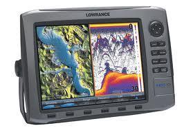
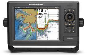
6 Significant charting and navigational aids Point-1 Antenna from Lowrance: Precision GPS Receiver with Electronic Compass AS GPS HS: Antenna from Humminbird: Precision GPS Receiver with Heading Sensor; also provides fast position fixes accurate within 2.5 meters. Navionics by Lowrance: Lake maps/charts on a card inserted into your unit. Navionics Gold, Platinum, HotMaps Platinum, etc. Lakemaster by Humminbird: Identified a range of water depth with Smartstrike by Humminbird: Conditions under which one or more fish are caught apply the software and it will identify similar contours, depths, etc. within a certain distance of your location. color. I-Pilot Link by MinnKota/Humminbird: Access trolling motor through sonar unit allowing for functions such as spot-lock, cruise control, navigation to a way point, etc. When used in conjunction with Lakemaster chart allows for follow-the-contour feature Pinpoint GPS / MotorGuide Gateway by Lowrance: Similar to I-Pilot Link for Lowrance and Motor Guide Xi5 trolling motors except for follow-the-contour.
7 CHARTING WAYPOINT UTILIZATION Most units will allow you to save one or more thousand waypoints. Waypoints different pictures for different use trees, underwater obstructions, etc. Waypoints may be used to mark trees and brush piles in more shallow water. When trolling with Lead Core/Down Riggers, waypoints may be used to mark fish. Waypoint the fish until you no long see them. This can help to avoid trolling over waters in which fish are not present. Apply one or more waypoints when finding fish for Down Line fishing. Application of waypoints in conjunction with your sonar and imaging may lead to a trolling chart for umbrella rig purposes.
8 CHARTING WAYPOINT UTILIZATION How about a different waypoint for water temperature? Example: Caught fish in Two Mile with surface water temperature of 80 degrees why not establish a special waypoint for surface water temps linked to catching fish? Then, establish a chart with the specific waypoint linked to places where fish were caught. Use your creativity and imagination to establish waypoints for a specific purpose.
9 SONAR WHERE IT WAS AND WHERE IT IS TODAY Sonar: Sound, Navigation, Ranging Developed during WW II to detect submarines Sonar: consists of a transmitter, transducer, receiver and display Sonar: transmitter emits sound pulses from your unit through the transducer. The sound pulses detect the bottom, fish, trees, etc. and this information is returned to the unit where it presents a display.

10 Sonar Efficient transducer success: properly High power transmitter installed Sensitive receiver High resolution/contrast display The display of almost all units is in color.
11 TRANSDUCERS A PRIMER Transducers: 50 khz; 83 khz; 200 khz; 455 khz: 200 khz works fine on Lanier. (Helpful Hint: Using the transducer while it is out of the water will shorten its life.) Transducer: 50 khz works well in deep saltwater. Transducers: Cone angles. The 200 khz generally has a 20 degree cone angle the shape is more elliptical than conical.

12 Chart for a 200 khz, 20 Degree Transducer: CONE ANGLE DEPTH - FEET DIAMETER 20 DEGREES 18 Feet 35 Feet 53 Feet 71 Feet Rule of Thumb: To determine the approximate diameter for 200 khz, divide depth by three. General Rule: higher frequencies are better suited for more shallow water.
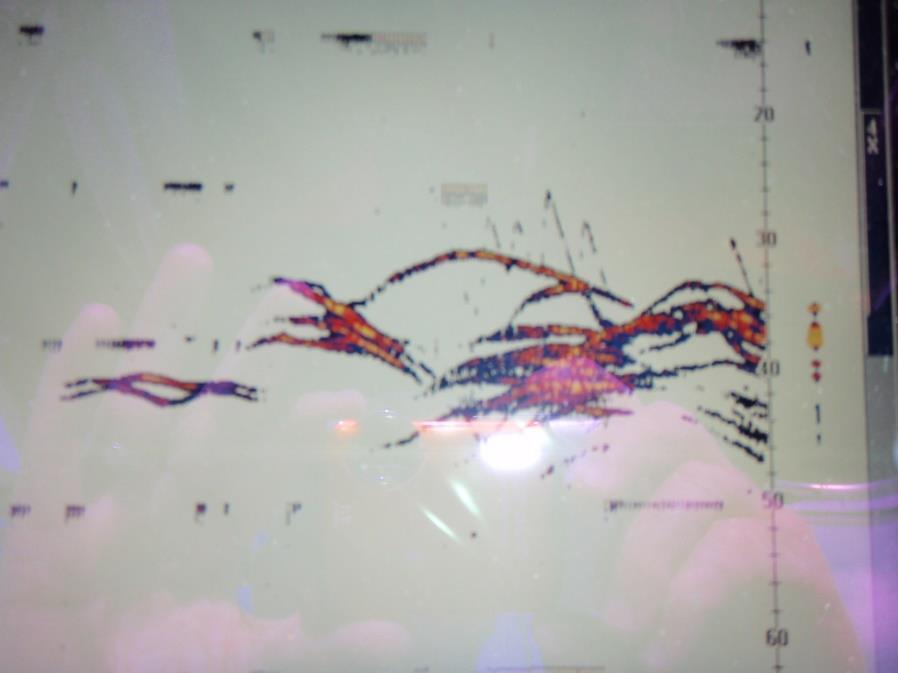
13 SONAR INTERPRETING DISPLAYS
14 During the summer, photo plankton and other microorganisms will be on the surface during the early morning hours. This helps to explain why fishermen see schools of Threadfin Shad on the surface early in the morning during the summer. The Threads are feasting on the plankton. Note: Threads thrive and reproduce in warm water.
15 During the summer, photo plankton and other microorganisms will be on the surface during the early morning hours. However, as the Sun casts its light on the water, plankton and microorganisms find their way to 30 to 40 feet where they many times appear as fish on your Display! The Display and Down Imaging can be very deceiving because in many cases your units are reporting arches. With its food source now at or near a thermocline, Threads usually retreat to deeper water.
16 During the warmest periods of summer in the morning, you will find Threadfin Shad on the surface feasting on plankton and microorganisms. Some plankton is sensitive to light; therefore, Threads will follow these small critters to greater depths as more light is emitted on the water.
17 During the fall and spring, Threadfin Shad can be found in shallow to fairly deep water remember that they thrive best in warm water temperature above 50 degrees F.
18 During the coldest periods of winter, Threadfin Shad are prime targets for Striped Bass as well as Spotted Bass. The Threads are very sensitive to water temperatures and will always seek the warmest water temperatures available to them. Because the Threads are a favorite for Stripers, it s always a good idea to fish around them. However, your fishing method(s) (Boards, Down Lines, Flat Lines) should be influenced by the depth of the Threads
19 While Blueback Herring thrive in cold water, they are susceptible to death should water temperatures fall to 44 degrees F. With water temperatures in the range of 45 to 50 in the winter your display will show them as a thin horizontal ban usually red in color
20 Blueback Herring thrive in cold water. During the summer a thermocline forms on the lake around 32 feet or so. Translationthe water form the surface to 32 fee is too warm for them to be comfortable. So during this time you will find them in a deeper depth. Regarding their display, look for inverted V s.

21 SONAR DISPLAY FISH

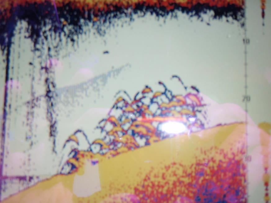
22 SONAR DISPLAY FISH

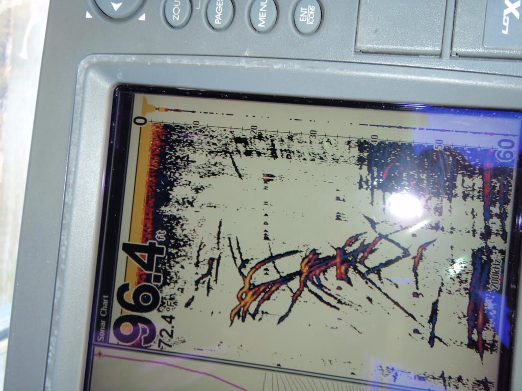
23 SONAR DISPLAY FISH
24 DOWN AND SIDE IMAGING: WHAT IS IT AND DO YOU NEED IT Benefits of Imaging: Down and side imaging or down scan/side scan encompass a very narrow beam, both straight down and side-to-side this contrasts with the traditional transducer which provides for the traditional cone shape. The result: a much more detailed display image. Also, the imaging transducer operates at a higher frequency, which generally results in greater resolution.
25 Can down and side imaging be a part of a large unit that also has sonar and charting features? Yes, as a matter of fact, this seems to be the current trend.
26 When turned on and your boat is traveling 2.5 mph or higher, down imaging is extremely effective in the identification of submerged structure such as trees and brush piles. On the other hand, if you are using Spot Lock or a similar feature and there is very little boat movement, down scan is not very effective.
27 Down Imaging A form of confirmation. Yep, down imaging confirms what your sonar picture is reporting or not reporting. On many days your down imaging will display both fish and bait that your sonar unit failed to report!


28 Side Imaging uses the same transducer. In some cases, images may be captured 240 feet on either or both sides of the boat. Excellent fish-finding tool.
29 Do I need Imaging? Yes, if the cost is within your fishing budget, I recommend the purchase. Why? Imaging detects both bait and fish which some sonar may not always display. It also confirms fish, trees, and structure and in many cases clearly reports a tree while the sonar display could easily be interpreted to be fish!

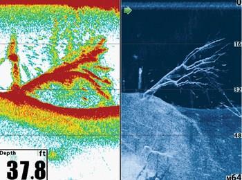
30 Example of Down Imaging
31 SUMMARY: LET S WRAP UP THIS PRESENTATION WITH AN INTERACTIVE DISCUSSION.
32 APPLICATION CRITERIA: Time of the year: July 30 Weekday Where: Six Mile Creek Sunrise to 2:00 P.M. Water temperature at Six Mile #10 at sunrise: 85 1:00 PM: 83 Wind: Light and variable Full Weather: Bright Sun with very few clouds. High of 92 F. Weather forecast for July 31: Same as July 30 Day of the Week: When: Water temperature at Six Mile #1 at Lake Level: Barometric Pressure: Steady On July 29 you started at Six Mile #10 and caught two Stripers. After 10:00 AM, you had some difficulty finding more fish in Six Mile. What tools do you have available? Charting, Sonar, Imaging? Questions: Where will you start your search? Why? What tools will you use?

33 For your use and information, see copy of map of Six Mile.
THE LAKE FACTOR WATER TEMPERATURES & CURRENTS
 THE LAKE FACTOR WATER TEMPERATURES & CURRENTS A fisherman s ability to reliably control the speed & temperature at the lure is one of the key to catching great lakes fish. Those fisherman that are willing
Precision Sonar. Electronics Tip of the Week. Sonar Accessory website:
 Precision Sonar Electronics Tip of the Week Sonar Accessory website: http://precisionsonar.com/index.htm Use Electronic Topo Maps & Lowrance StructureScan To Locate High Percentage Areas In our sonar class
To Book a trip call or visit our website
 To Book a trip call 270-703-6133 or visit our website www.kicknbass.net October 27th, 2011 Lake Conditions Lake Levels As of this morning both lakes are holding steady at winter pool give or take a few
CELEBRATING 30 YEARS
 1988-2017 CELEBRATING 30 YEARS 1st Place - Jason & Rich Shaw 1st Place 1 Lake news 1 Tournament Sponsor 2 Big Bass 2 Results (Places) 3 Event Pictures 4-7 Ledge Fishing 8-9 Complete Results 10 AOY Race
Utilizing Vessel Based Mobile LiDAR & Bathymetry Survey Techniques for Survey of Four Southern California Breakwaters
 Utilizing Vessel Based Mobile LiDAR & Bathymetry Survey Techniques for Survey of Four Southern California Breakwaters Western Dredging Association: Pacific Chapter September 2012 Insert: Pipe Location
To Book a trip call or visit our website
 To Book a trip call 270-703-6133 or visit our website www.kicknbass.net May 10, 2013 Lake Conditions Lake Levels Note: Both Dams will be Spilling Until Further Notice. As of this morning both lakes are
Experience Great Fishing
 To Book a trip call 270-703-6133 or visit our website www.kicknbass.net April 25, 2014 Lake Conditions Both lakes are within inches of summer pool. For more information including a generation schedule
INTRODUCTION TO STRUCTURE FISHING: IDENTIFICATION OF FISH LOCATIONS STRUCTURE FISHING
 INTRODUCTION TO STRUCTURE FISHING: IDENTIFICATION OF FISH LOCATIONS Featuring: - Migration Theory of fish. - Structure types: Point Bar Underwater Hump Channel Man Made - Understanding Breaks & Breaklines
To Book a trip call or visit our website
 Feb. 28, 2013 Lake Conditions To Book a trip call 270-703-6133 or visit our website www.kicknbass.net Lake Levels As of this morning both lakes are approximately 2 feet above winter pool. Some gates are
To Book a trip call or visit our website
 To Book a trip call 270-703-6133 or visit our website www.kicknbass.net March 7, 2014 Lake Conditions Several of the gates are open at Kentucky Dam creating significant current in the lake. Boat Ramp Conditions
Using Sonar for Navigation
 Using Sonar for Navigation By Steve Dashew We spend a lot of time cruising in remote areas, where charts tend to be out-of-date or nonexistent. For years we've been thinking about using sonar for navigation
Experience Great Fishing Adventures On the Kick n Bass Pontoon
 == To Book a trip call 270-703-6133 or visit our website www.kicknbass.net May 9, 2014 Lake Conditions Both lakes are about a foot over summer pool. Kentucky Dam will be spilling until further notice.
_A - 747c_&_777c2_Man_Eng.qxp 10/2/2006 1:40 AM Page c and 777c 2 Operations Manual _A
 531526-1_A - 747c_&_777c2_Man_Eng.qxp 10/2/2006 1:40 AM Page 1 747c and 777c 2 Operations Manual 531526-1_A 531526-1_A - 747c_&_777c2_Man_Eng.qxp 10/2/2006 1:40 AM Page 2 Thank You! Thank you for choosing
echo 200, 300, and 500 Series Owner s Manual
 echo 200, 300, and 500 Series Owner s Manual November 2013 190-01709-00_0A Printed in Taiwan All rights reserved. Under the copyright laws, this manual may not be copied, in whole or in part, without the
IF YOU ARE PLANNING ON VISITING OUR LAKES I HIGHLY RECOMMEND THE FOLLOWING BUSINESSES FOR ALL YOUR FISHING AND BOATING NEEDS:
 November 11, 2016 Kentucky Lake: Water Level at Kentucky Dam - 354.44 Surface Temperature - 65 Lake Barkley: Water Level at Barkley Dam - 354.45 Surface Temperature - 65 Both lakes are a few inches over
141c Operations Manual _B
 141c Operations Manual 531442-1_B Thank You! Thank you for choosing Humminbird, America's #1 name in fishfinders. Humminbird has built its reputation by designing and manufacturing top-quality, thoroughly
500 Series Operations Manual _A
 500 Series Operations Manual 531521-1_A Thank You! Thank you for choosing Humminbird, America's #1 name in fishfinders. Humminbird has built its reputation by designing and manufacturing topquality, thoroughly
Recommended operating guidelines (ROG) for sidescan Sidescan sonar ROG in wrapper.doc English Number of pages: 9 Summary:
 for sidescan Sidescan sonar ROG in wrapper.doc English Number of pages: 9 Summary:") Title: Author(s): Document owner: Recommended operating guidelines (ROG) for sidescan sonar Dave Long (BGS) Dave Long (BGS) Reviewed by: Janine Guinan (MI) 07/09/07 Workgroup: MESH action: 2.1 Version:
Title: Author(s): Document owner: Recommended operating guidelines (ROG) for sidescan sonar Dave Long (BGS) Dave Long (BGS) Reviewed by: Janine Guinan (MI) 07/09/07 Workgroup: MESH action: 2.1 Version:
14/10/2013' Bathymetric Survey. egm502 seafloor mapping
 egm502 seafloor mapping lecture 10 single-beam echo-sounders Bathymetric Survey Bathymetry is the measurement of water depths - bathymetry is the underwater equivalent of terrestrial topography. A transect
To Book a trip call or visit our website *** Special Announcement ***
 To Book a trip call 270-703-6133 or visit our website www.kicknbass.net March 8th, 2012 *** Special Announcement *** Relief is in sight involving the Eggners Ferry Bridge and a plan to reopen it to traffic.
Challenges in determining water surface in airborne LiDAR topobathymetry. Amar Nayegandhi, Dewberry 15 th Annual JALBTCX Workshop, June 11 th 2014
 Challenges in determining water surface in airborne LiDAR topobathymetry Amar Nayegandhi, Dewberry 15 th Annual JALBTCX Workshop, June 11 th 2014 Why topobathy LiDAR? Complements acoustic (multi-beam sonar)
To Book a trip call or visit our website
 To Book a trip call 270-703-6133 or visit our website www.kicknbass.net Oct. 27th, 2012 Lake Conditions Lake Levels As of this morning both lakes approximately 2.75 feet below summer pool and on a steady
To Book a trip call or visit our website
 April 5, 2013 Lake Conditions To Book a trip call 270-703-6133 or visit our website www.kicknbass.net Lake Levels As of this morning both lakes are approximately 1.75 below summer pool and on a slow rise.
Lake Powell Fish Report May 2, 2018 Lake Elevation: 3609 Water temperature: F By: Wayne Gustaveson or Wayneswords.
 Lake Powell Fish Report May 2, 2018 Lake Elevation: 3609 Water temperature: 59-64 F By: Wayne Gustaveson http://www.wayneswords.com or Wayneswords.net It s typically springtime weather with some warm days
To Book a trip call or visit our website
 To Book a trip call 270-703-6133 or visit our website www.kicknbass.net May 23, 2014 To all of You Have a Happy and Safe Memorial Day! Lake Conditions This week we ve had steady conditions and both lakes
Fall Crappie Fishing is HOT on the Kick n Bass Pontoon. Book Your Trip NOW!
 Oct. 4th, 2013 To Book a trip call 270-703-6133 or visit our website www.kicknbass.net Fall Crappie Fishing is HOT on the Kick n Bass Pontoon. Book Your Trip NOW! (Photo Left) Steve Hall & J.B. Fischer
BOTTOM MAPPING WITH EM1002 /EM300 /TOPAS Calibration of the Simrad EM300 and EM1002 Multibeam Echo Sounders in the Langryggene calibration area.
 BOTTOM MAPPING WITH EM1002 /EM300 /TOPAS Calibration of the Simrad EM300 and EM1002 Multibeam Echo Sounders in the Langryggene calibration area. by Igor Kazantsev Haflidi Haflidason Asgeir Steinsland Introduction
Fall Crappie Fishing is HOT on the Kick n Bass Pontoon. Book Your Trip NOW!
 To Book a trip call 270-703-6133 or visit our website www.kicknbass.net Friday October 25th, 2013 Fall Crappie Fishing is HOT on the Kick n Bass Pontoon. Book Your Trip NOW! (Photo L) Now there s one happy
To Book a trip call or visit our website
 To Book a trip call 270-703-6133 or visit our website www.kicknbass.net March 16th, 2012 Lake Conditions Lake Levels and Water Conditions As of this morning both lakes were approximately 1.5 feet above
FISHFINDER OPERATIONS
 SPOT Spot-Lock LOCK FISHFINDER OPERATIONS minnkotamotors.com 55 How WAYPOINT NAVIGATION Works WAYPOINT REMOTE OPERATIONS Waypoints are stored positions that allow you to mark areas of interest or navigation
York River Marine Debris Survey (Off-season)
") York River Marine Debris Survey- Marine Debris Removal Jan/Feb 2006 (Off-season) Kirk Havens David Stanhope Kory Angstadt Center for Coastal Resources Management Virginia Institute of Marine Science Sarah
York River Marine Debris Survey- Marine Debris Removal Jan/Feb 2006 (Off-season) Kirk Havens David Stanhope Kory Angstadt Center for Coastal Resources Management Virginia Institute of Marine Science Sarah
PAPER 2 THEORY QUESTIONS
 PAPER 2 THEORY QUESTIONS 1 (a) Water waves are transverse waves. Sound is a longitudinal wave. (i) Describe the difference between transverse waves and longitudinal waves. In your account, draw a diagram
Copicut Reservoir Sidescan Sonar. Fall River, MA May 7, 2013
 Copicut Reservoir Sidescan Sonar Fall River, MA May 7, 2013 1 Table of Contents Section 1: Mission Overview... 3 Background... 3 Vehicle General Information... 3 Vehicle Mission Details... 4 Area of Operation...
Advantages of Using Combined Bathymetry and Side Scan Data in Survey Processing T.M. Hiller, L.N. Brisson
 Advantages of Using Combined Bathymetry and Side Scan Data in Survey Processing T.M. Hiller, L.N. Brisson EdgeTech, West WareHam MA, USA EdgeTech 6205 Combined Bathymetric and Side Scan Sonar EdgeTech
USER S GUIDE DepthTrax 1H HawkEye Portable Depth Finder (DT1H)
") USER S GUIDE DepthTrax 1H HawkEye Portable Depth Finder (DT1H) Thank you for purchasing a HawkEye product, and welcome to the innovations of NorCross Marine Products, Inc. To ensure safety and many years
USER S GUIDE DepthTrax 1H HawkEye Portable Depth Finder (DT1H) Thank you for purchasing a HawkEye product, and welcome to the innovations of NorCross Marine Products, Inc. To ensure safety and many years
Prime Feeding Times For Gilbertsville, KY Date Temps Sun Data Moon Data Moon Phase Major Times Minor Times Prediction. 3% Waxing Crescent
 To Book a trip call 270-703-6133 or visit our website www.kicknbass.net Dec. 14 th, 2012 Lake Conditions Lake Levels As of this morning both lakes are sitting approximately 1.5 foot above winter pool.
Operations Manual. Matrix 10 Matrix 27. Matrix 17 Matrix 37. offered by Busse-Yachtshop.de _A
 Operations Manual 531284-2_A Matrix 10 Matrix 27 Matrix 17 Matrix 37 Thank You! Thank you for choosing Humminbird, America's #1 name in fishfinders. Humminbird has built its reputation by designing and
When fishing gets tough, trust Fish Hawk. For over 30-years Fish Hawk Electronics has been giving anglers speed, temperature, and depth information
 When fishing gets tough, trust Fish Hawk. For over 30-years Fish Hawk Electronics has been giving anglers speed, temperature, and depth information at the downrigger ball. Maintaining proper lure speed
To Book a trip call or visit our website
 Aug. 29, 2014 To Book a trip call 270-703-6133 or visit our website www.kicknbass.net Lake Conditions This week both lakes are approximately 2.5 feet below summer pool and falling slightly during the seasonal
Navigation with Leeway
 Navigation with Leeway Leeway, as we shall use the term, means how much a vessel is pushed downwind of its intended course when navigating in the presence of wind. To varying extents, knowledge of this
Advanced PMA Capabilities for MCM
 Advanced PMA Capabilities for MCM Shorten the sensor-to-shooter timeline New sensor technology deployed on off-board underwater systems provides navies with improved imagery and data for the purposes of
TRANSDUCER RESOURCE GUIDE EN_A
 TRANSDUCER RESOURCE GUIDE 532651-1EN_A THANK YOU! Thank you for choosing Humminbird, the #1 name in marine electronics. Humminbird has built its reputation by designing and manufacturing top quality, thoroughly
To Book a trip call or visit our website
 To Book a trip call 270-703-6133 or visit our website www.kicknbass.net Jan. 31, 2013 Lake Conditions Lake Levels As of this morning both lakes are approximately ½ foot above winter pool. The gates are
DOWNLOAD OR READ : TROLLING FOR STRIPED BASS AND BLUEFISH PDF EBOOK EPUB MOBI
 DOWNLOAD OR READ : TROLLING FOR STRIPED BASS AND BLUEFISH PDF EBOOK EPUB MOBI Page 1 Page 2 trolling for striped bass and bluefish trolling for striped bass pdf trolling for striped bass and bluefish How
today s fishermen by Dennis Foster I Defining technology for Modern electronics play a key role in fishing success
 Modern electronics play a key role in fishing success Defining technology for today s fishermen by Dennis Foster I In the last few decades the ever-increasing presence of technology-specifically computer
Marine Mammal Acoustic Tracking from Adapting HARP Technologies
 DISTRIBUTION STATEMENT A: Approved for public release; distribution is unlimited. Marine Mammal Acoustic Tracking from Adapting HARP Technologies Sean M. Wiggins and John A. Hildebrand Marine Physical
To Book a trip call or visit our website
 To Book a trip call 270-703-6133 or visit our website www.kicknbass.net October 20th, 2011 Lake Conditions Lake Levels As of this morning both lakes are approximately 4 feet below summer pool, give or
To Book a trip call or visit our website
 To Book a trip call 270-703-6133 or visit our website www.kicknbass.net April 20th, 2012 Lake Conditions Lake Levels As of this morning both lakes were approximately 2.5 feet below summer pool and in the
PIRANHA I & 2 OPERATION GUIDE
 PIRANHA I & 2 OPERATION GUIDE Thank You Thank you for purchasing a Piranha fishfinder from Humminbird, America s #1 Manufacturer of quality consumer marine electronics WARNING! This device should not be
To Book a trip call or visit our website
 To Book a trip call 270-703-6133 or visit our website www.kicknbass.net July 11, 2014 Lake Conditions This week both lakes are at summer pool. For more information including a generation schedule visit
INTERNATIONAL HYDROGRAPHIC SURVEY STANDARDS
 INTERNATIONAL HYDROGRAPHIC SURVEY STANDARDS by Gerald B. MILLS 1 I. Background The International Hydrographic Organization (IHO) traces its origin to the establishment of the International Hydrographic
Prime Feeding Times For Gilbertsville, KY Date Temps Sun Data Moon Data Moon Phase Major Times Minor Times Prediction. 38% Waning Crescent
 To Book a trip call 270-703-6133 or visit our website www.kicknbass.net Dec.7 th, 2012 Lake Conditions Lake Levels As of this morning both lakes are sitting approximately one foot above winter pool. For
Scanning Sonar and ROV Operations. For Underwater SAR Imaging Applications
 Scanning Sonar and ROV Operations For Underwater SAR Imaging Applications This training module provides information specific to integrating scanning sonar onto an ROV platform and fundamentals in using
Specifications for Synchronized Sensor Pipe Condition Assessment (AS PROVIDED BY REDZONE ROBOTICS)
") Specifications for Synchronized Sensor Pipe Condition Assessment (AS PROVIDED BY REDZONE ROBOTICS) A. Scope of Work The work covered by these specifications consists of furnishing all materials, labor,
Specifications for Synchronized Sensor Pipe Condition Assessment (AS PROVIDED BY REDZONE ROBOTICS) A. Scope of Work The work covered by these specifications consists of furnishing all materials, labor,
 Page 1 of 6 Nav-Aid Basics Unlike the roads and highways that we drive on, the waterways we go boating on do not have road signs that tell us our location, the route or distance to a destination, or of
To Book a trip call or visit our website
 To Book a trip call 270-703-6133 or visit our website www.kicknbass.net Nov. 5th, 2015 Lake Levels Caution Lower water levels! Know where you are at all times when running and use the channel markers,
PiranhaMAX & Fishin Buddy MAX
 PiranhaMAX & Fishin Buddy MAX Thank You! Thank you for choosing Humminbird, the #1 name in marine electronics. Humminbird has built its reputation by designing and manufacturing top-quality, thoroughly
Largemouth Bass: Smallmouth Bass: Productive Lures: Crappie:
 April 10, 2015 Kentucky Lake: Water Level at Kentucky Dam - 356.68 Surface Temperature - 62 Lake Barkley: Water Level at Barkley Dam - 356.80 Surface Temperature - 62 Both lakes are about 2.5 feet below
Marine Towed Array Surveys of Ostrich Bay, Lake Erie and Puerto Rico.
 Marine Towed Array Surveys of Ostrich Bay, Lake Erie and Puerto Rico. Chet Bassani, Nagi Khadr, Chris Gibson and Jim McDonald Advanced Sensors and Analysis Div., SAIC Cary, NC Marine Towed Array (MTA)
SEASONS SPRING SUMMER FALL WINTER DIRECT CORRELATION BETWEEN SEASONS AND WATER TEMPS
 LAKE EVERGREEN DEC. 27, 2014 CRAPPIE BASICS 2014 SEASONS SPRING SUMMER FALL WINTER DIRECT CORRELATION BETWEEN SEASONS AND WATER TEMPS 3 T S TO HELP YOU CATCH MORE CRAPPIE TEMPS TACTICS TACKLE ALIGNING
Walleye are caught on bottom bouncers with worms, on plastic baits retrieved close to the. May 30, Bluegill Prizes Awarded this Week.
 Lake Powell Fish Report May 30, 2018 Lake Elevation: 3611 Water temperature: 67-74 F By: Wayne Gustaveson http://www.wayneswords.com or Wayneswords.net Lake Powell continues to rise with inflow doubling
Nautical Navigation: Final Quiz
 Name: Nautical Navigation Final Quiz Class: (ver. 03/09/15) Date: Page 1 of 9 Nautical Navigation: Final Quiz There are three sections: Multiple Choice, True/False, and Short Answer. For the multiple choice,
January (Santa) Fred England, TSBA Member and Sponsor
 Fred England, TSBA Member and Sponsor") January 2014 (Santa) Fred England, TSBA Member and Sponsor Letter from the Prez As I begin my term as President of TSBA I want to start by thanking Doug Steffe for his leadership over the last few years.
January 2014 (Santa) Fred England, TSBA Member and Sponsor Letter from the Prez As I begin my term as President of TSBA I want to start by thanking Doug Steffe for his leadership over the last few years.
Emerging Subsea Networks
 THE FUTURE OF MARINE SURVEY APPLICATIONS FOR SUBMARINE CABLES Ryan Wopschall (Fugro) Email: rwopschall@fugro.com Fugro Pelagos, Inc. - 3574 Ruffin Road, San Diego, California 92123 USA Abstract: New advances
To Book a trip call or visit our website
 To Book a trip call 270-703-6133 or visit our website www.kicknbass.net July 20 th, 2013 Lake Conditions Lake Levels Both lakes are approximately ½ foot above summer pool but projected to be at summer
MARINE NAVIGATION LESSON PLAN See That Sound?
 Marine Navigation Hydrography Lesson Plan MARINE NAVIGATION LESSON PLAN See That Sound? Theme Hydrographic Survey Links to Overview Essays and Resources Needed for Student Research http://oceanservice.noaa.gov/topics/navops/hydrosurvey/
Lake Mead Fishing Fun
 Lake Mead Fishing Fun Lake Mead Fishing Fun Location: : Lake Mead can only be described as really, really big. Located in Southern Nevada as part of the Colorado River System, it lies along the Arizona-Nevada
To Book a trip call or visit our website
 To Book a trip call 270-703-6133 or visit our website www.kicknbass.net October 6th, 2011 Lake Conditions Lake Levels As of this morning both lakes are approximately 3 feet below summer pool, give or take
Small Footprint Topo-Bathymetric LiDAR
 May 8, 2013 Small Footprint Topo-Bathymetric LiDAR PNAMP Remote Sensing Forum Russ Faux, Co-CEO, WSI Amar Nayegandhi, Manager of Elevation Technologies, Dewberry Colin Cooper, Senior Analyst, WSI Watershed
INTRODUCTION TO NETWORK WIND 3 MOUNTING THE UNIT 14 SELECTING THE DISPLAY MODE 5 ABBREVIATIONS AND DEFINITIONS 17
 CONTENTS CONTENTS 1 INSTALLATION 14 GENERAL INTRODUCTION TO B&G NETWORK 2 SITING THE UNIT 14 INTRODUCTION TO NETWORK WIND 3 MOUNTING THE UNIT 14 EXAMPLE SYSTEMS USING NETWORK WIND 4 SPECIFICATION 16 SELECTING
Hydrographic Surveying Methods, Applications and Uses
 Definition: Hydrographic Surveying Methods, Applications and Uses It is the branch of surveying which deals with any body of still or running water such as a lake, harbor, stream or river. Hydrographic
MARITIME UNIVERSITY IN SZCZECIN ORGANIZATIONAL UNIT: FACULTY OF NAVIGATION - DEPARTMENT OF NAVIGATION DEVICES. Instruction
 MARITIME UNIVERSITY IN SZCZECIN ORGANIZATIONAL UNIT: FACULTY OF NAVIGATION - DEPARTMENT OF NAVIGATION DEVICES Instruction PRINCIPLE OF OPERATION AND HANDLING OF THE NAVIGATION ECHOSOUNDER (Echosonda GPSMAP
Pascagoula River Marsh 2017 REEL FACTS Stephen Brown Fisheries Biologist
 Pascagoula River Marsh 217 REEL FACTS Stephen Brown Fisheries Biologist stephenb@mdwfp.state.ms.us General Information: The Pascagoula River marsh is 25 acres of tidal creeks, canals, bays, and streams
EFFECTIVE & RELIABLE INSPECTION OF FIN-FAN COOLER TUBES
 7 th MENDT Conference Bahrain - 2015 EFFECTIVE & RELIABLE INSPECTION OF FIN-FAN COOLER TUBES ANDREAS BOENISCH & ABDUL RAHMAN TAQATEQ CONTENT - Short overview Fin Fan Cooler & Tube Types, Tube corrosion
To Book a trip call or visit our website
 To Book a trip call 270-703-6133 or visit our website www.kicknbass.net Aug. 3rd, 2013 Lake Conditions Lake Levels Both lakes are approximately ¾ foot below summer pool and in the midst of a slow drawdown.
To Book a trip call or visit our website
 Aug 10th, 2012 To Book a trip call 270-703-6133 or visit our website www.kicknbass.net Lake Conditions Lake Levels As of this morning both lakes approximately 6 inches below summer pool and on a very slow,
This guide relates to the CPN Series Chart Plotters CPN700i and CPN1010i
 This guide relates to the CPN Series Chart Plotters CPN700i and CPN1010i For older GPS Chart Plotters, the manual is available for download at www.standardhorizon.com or by contacting Marine Product Support
Calaveras Big Trees State Park--South Grove Loop
 Copyright 1999 by Jeff Robinson. You are free to use and reproduce this description for personal, not-for-profit, and not-forbusiness use. Any reproduction other than for personal use, including businesses,
Fishing Updates / Comments. Bad Fishing Joke
 Published Bi-Weekly: Week of February 11, 2016 Fishing Updates / Comments Lake Fishing Update (from Ken Sturdivant) - CLARK HILL IS DOWN 1.5 FEET, HIGH 40 S Bass fishing if fair. A good bait is the jig
To Book a trip call or visit our website
 July 27th, 2012 Lake Conditions To Book a trip call 270-703-6133 or visit our website www.kicknbass.net Lake Levels As of this morning both lakes are within inches of summer pool and basically holding
Ross Barnett Reservoir 2019
 Ross Barnett Reservoir 19 Reel Facts Ryan Jones Fisheries Biologist Ryan.Jones@wfp.ms.gov (1) 89-31 General Information: Ross Barnett Reservoir is a 33, acre impoundment of the Pearl River. It consists
The Dalles Dam Powerhouse Trash Rack ROV Inspection Report
 The Dalles Dam Powerhouse Trash Rack ROV Inspection Report Report date: 8/21/13; Inspection conducted for: ROV Inspection by: Inspection location: The Dalles Dam, POC Robert Cordie; NWP Office of Dive/
Pascagoula River Marsh 2018 REEL FACTS Stephen Brown Fisheries Biologist
 Pascagoula River Marsh 218 REEL FACTS Stephen Brown Fisheries Biologist stephenb@mdwfp.state.ms.us General Information: The Pascagoula River marsh is 25 acres of tidal creeks, canals, bays, and streams
New Bedford Fishing Heritage Center
 Lesson Title: Duration: 1-50 minute class period Overview: Students practice geography and math skills while learning about their relevancy to commercial fishing such as pinpointing locations, locating
Claytor Lake View of the Claytor Lake dam from Claytor Lake State Park s boat ramp.
 Claytor Lake 2007 Imagine yourself on a waterbody that is more like a wide river than a lake. When you do, you will have a picture of Claytor Lake. Claytor Lake, a 4,475-acre reservoir, stretches northeastward
ROUTES CAN MESS IT UP
 ROUTES CAN MESS IT UP FROM THIS SEASON, CHART SUPPLIERS NAVIONICS, C-MAP AND BLUECHART, OFFER AUTOMATIC ROUTE PLANNING. WE HAVE TESTED ALL. THE DIFFERENCES IN BOTH USER INTERFACE AND QUALITY OF THE ROUTES
Level MEASUREMENT 1/2016
 Level MEASUREMENT 1/2016 AGENDA 2 A. Introduction B. Float method C. Displacer method D. Hydrostatic pressure method E. Capacitance method G. Ultrasonic method H. Radar method I. Laser method J. Level
To Book a trip call or visit our website
 June 1st, 2012 To Book a trip call 270-703-6133 or visit our website www.kicknbass.net Lake Conditions Lake Levels As of this morning both lakes were approximately 1.5 feet below summer pool and basically
To Book a trip call or visit our website
 To Book a trip call 270-703-6133 or visit our website www.kicknbass.net Jan. 11, 2013 Lake Conditions Lake Levels As of this morning both lakes are approximately ½ foot above winter pool. For additional
Doppler current meter
 JLN-652 Doppler current meter JRC's new 240 khz Doppler current meter: the smartest way to increase your catch Unique 3D twist mode presentation Measuring up and down current 50 independent measuring layers
Ross Barnett Reservoir 2018
 Ross Barnett Reservoir 18 Reel Facts Ryan Jones Fisheries Biologist Ryanj@mdwfp.state.ms.us (61) 89-341 General Information: Ross Barnett Reservoir is a 33, acre impoundment of the Pearl River. It consists
Lake Powell Fishing Report July 23, 2014 Lake Elevation: 3608 Water Temperature F By: Wayne Gustaveson
 Lake Powell Fishing Report July 23, 2014 Lake Elevation: 3608 Water Temperature 77-85 F By: Wayne Gustaveson http://www.wayneswords.com STRIPERS BOILING! Big news began pouring in on July 25th. Stripers
E4014 Construction Surveying. Hydrographic Surveys
 E4014 Construction Surveying Hydrographic Surveys Charts And Maps Hydrographic Chart an information medium and a tool for maritime traffic for the safety and ease of navigation contains information on
Homework 2 Bathymetric Charts [based on the Chauffe & Jefferies (2007)]
![Homework 2 Bathymetric Charts [based on the Chauffe & Jefferies (2007)]](/thumbs/75/72427079.jpg "Homework 2 Bathymetric Charts [based on the Chauffe & Jefferies (2007)]") 1 MAR 110 HW-2 - Bathy Charts Homework 2 Bathymetric Charts [based on the Chauffe & Jefferies (2007)] 2-1. BATHYMETRIC CHARTS Bathymetric charts are maps of a region of the ocean used primarily for navigation
1 MAR 110 HW-2 - Bathy Charts Homework 2 Bathymetric Charts [based on the Chauffe & Jefferies (2007)] 2-1. BATHYMETRIC CHARTS Bathymetric charts are maps of a region of the ocean used primarily for navigation
October Greg Dee, with his new personal best
 October 2013 Greg Dee, with his new personal best Letter from the Prez Greetings Fishing Friends, The Fall fishing season has arrived. This last month, East TN lakes and rivers have had an aggressive drop
New Highly Productive Phased Array Ultrasonic Testing Machine for Aluminium Plates for Aircraft Applications
 19 th World Conference on Non-Destructive Testing 2016 New Highly Productive Phased Array Ultrasonic Testing Machine for Aluminium Plates for Aircraft Applications Christoph HENKEL 1, Markus SPERL 1, Walter
To Book a trip call or visit our website
 To Book a trip call 270-703-6133 or visit our website www.kicknbass.net July 26 th, 2013 Lake Conditions Lake Levels Both lakes at summer pool and projected to stay that way for the next several days.
Navigation & Orienteering: Pre- Test
 Name: Class: Answer Key Date: Page 1 of 7 Navigation & Orienteering: Pre- Test There are three sections: Multiple Choice, True/False, and Short Answer. For the multiple choice, please select the BEST answer
2014 Advantage Boating Sail Canada Basic Cruising Standard. Section III: Part B Safety Safety Guidelines and Avoiding Hazards
 Section III: Part B Safety Safety Guidelines and Avoiding Hazards Lesson Outline Lesson Objectives Introduction Navigation lights Distress signals Hazards Radar reflector Summary Quiz 2 Lesson Objectives
StriperTackle Charters StriperTackle Charter Service, Year Round Striper Fishing
 1 of 5 12/9/2010 9:14 PM ArkansasStripers.com Striper Fishing Guides Live Shad for Stripers Catch and Release Can Kill Stripers Live Wells for Stripers Striper Age Weight Chart Spawning Best Times To Catch