Iron Mining In the Penokee Range- What s at Risk Penokee Range
|
|
|
- Kory Higgins
- 5 years ago
- Views:
Transcription

1 Iron Mining In the Penokee Range- What s at Risk Penokee Range Dale A. Thomas/NP Studios

2 Introduction The Penokee Gogebic Range extends 25 miles in far northern Wisconsin, through Iron and Ashland counties. The range consists of two steep, parallel ridges that dominate the local landscape rising 1200 feet from nearby Lake Superior. The topography of the area and the variety of soil conditions result in a wide range of habitat that supports a diverse group of species and natural communities. For decades, this property has been managed for hardwood timber production, including maple and yellow birch. Pine, hemlock, ash and aspen are also on the property. Currently, the majority of the land is enrolled in Wisconsin s Managed Forest Law. Managed Forest Law requires a management plan to sustain production of timber products and large areas for public recreational uses, including hunting, hiking, and snowmobiling. The forests provide habitat and hunting opportunities for upland birds and big game including, ruffed grouse, white-tail deer and black bear. The forests are close to the state s reintroduced elk herd. Many of the streams on the property are Class I trout streams with naturally reproducing populations of brook, brown and rainbow trout. The majority of the Penokee Range is owned by RGGS Land and Minerals out of Houston Texas and La Point Mining Co in Minnesota. Together, these companies control a narrow 22-mile, 22,000 acre band in the Penokee Range from southwest of Hurley, WI to about six miles west of Mellen, WI. The Cline Group, out of Florida, has secured an option to obtain the mineral rights held for this property and has created a subsidiary called Gogebic Taconite (G-TAC) to move forward with the mining of iron. Why is this land important The Penokee mining land encompasses: Nearly 35 square miles of northern hardwood forest, Fifty-six miles of perennial river and stream frontage on more than 20 waterways, Frontage on English and Beaver lakes. It is in close proximity to Copper Falls State Park, The Nature Conservancy/DNR cooperative project at Caroline Lake State Natural Area, Devil s Creek State Fishery Area, Segments of the North Country National Trail. This land helps maintain the forest cover in a landscape that links the Chequamegon-Nicolet National Forest in northern Wisconsin to the Ottawa National Forest in the Upper Peninsula of Michigan. This land provides habitat for wide ranging mammals, such as timber wolves and Pine martins, and for breeding populations of migrant songbirds, such as the black-throated blue warbler. Dale A Thomas/NP Studios View from top of Mount Whittlesey 2
.")
.")
3 The Penokee Range is identified as an important area of high conservation significance due to its unique geology; many rare plants, animals and forest communities; and high quality recreational opportunities (WI Land Legacy Rpt, 2006). This landscape was included in the DNR s Forest Legacy Assessment of Need (2001); The Wisconsin Wildlife Action Plan identified the Penokee Range as an Important Bird Area and a Conservation Opportunity Area of Continental Significance to maintain a large continuous climate change resistant forest (2008). The Penokees have also been identified by The Nature Conservancy and its partners in the Great Lakes Ecoregional Plan (2000) as a large block of forest important for declining forest birds such as the golden-winged warbler, blackburnian warbler and goshawk. The forests also provide an important function in maintaining the quality and quantity of water that eventually empties into the Kakagon/Bad River Sloughs a United State Department of Interior designated National Natural Landmark. Mount Whittlesey Matt Dallman/TNC Scott W. Mulcahy Scott W. Mulcahy Robert A. Kleppin Lawrence Michael Robert A. Kleppin 3

4 Bad River Risks to Unique Water Resources Matt Dallman/TNC The Penokee mining land has the potential to impact a large portion of the headwaters of the Bad River watershed. Fifty-six miles of perennial, and 15 miles of intermittent waterways flow through the mining land. Due to their high elevation and close proximity to Lake Superior, the Penokees average over 200 inches of snow a year. The quantity, temperature, and nutrients of this water have significant impacts on water resources downstream including the Bad River, the Kakagon/Bad River sloughs and finally Lake Superior. The Bad River flows through a wide variety of habitats in a relatively short span. Starting in the forested heights of the Penokee range it quickly drops through deep forests in Copper Falls State Park and over the escarpment into spectacular canyons and waterfalls. Below Copper Falls, the Bad River flows through lowland forests and out to the sloughs where the river meets Lake Superior. Segments of the Bad River, Kakagon River, Bear Trap Creek, and Wood Creek are all designated as Outstanding Natural Resource Waters by the State of Wisconsin. These systems are all dependent on surface and ground water that originates in the Penokee Range. The Bad River also provides important spawning habitat for the lake sturgeon and many game fish. At the mouth of the Bad River are some of the largest and highest quality coastal wetlands in the Great Lakes. The 16,000-acre Kakagon/Bad River Sloughs, which have been called Wisconsin s Everglades, are an ecosystem of national significance and were designated as a National Natural Landmark by the U.S. Dept. of the Interior in The Kakagon-Bad River Sloughs are home to many threatened and endangered species such as the Piping Plover, Trumpeter Swan, Yellow Rail, Bald Eagle, wood turtle, and ram s-head lady-slipper orchid. 4


5 The Penokee range is also a key piece of the land for drinking water. This area makes up the headwaters of the drinking water source both surface and groundwater, for the Municipalities of Ashland, Mellen, Highbridge, Marengo, Odanah, and Upson. Finally the rise in elevation of the Penokees creates the hydrologic pressure that supports the abundance of artesian wells found along the Chequamegon Bay shoreline. Within Lake Superior itself, the ground water upwellings generated by this hydrologic pressure are critical spawning areas for many great lakes fishes. Ryan Brady Long Island, Lake Superior Gerald H. Emmerich, Jr. Piping Plover Chequamegon Bay Ted Cline 5
 Erickson Creek Opergard Creek Ballou Creek (E) Gehrman Creek Potato River (O) Barr Creek (E) Gravelly Brook Rocky Run Camp Six Creek Happy Creek Rouse")
6 The following rivers/streams flow through the Penokee mining property (E and O indicate that portions of these waterways are designated as Exceptional or Outstanding Resource Waters): Apple Creek Edies Creek Montreal Creek Bad River (E and O) Erickson Creek Opergard Creek Ballou Creek (E) Gehrman Creek Potato River (O) Barr Creek (E) Gravelly Brook Rocky Run Camp Six Creek Happy Creek Rouse Creek City Creek Hardscrabble Creek Tafelski Creek Devils Creek (E) Javorsky Creek (E) Tyler Forks (E and O) Dunn Creek Krause Creek (E) Several unnamed 6


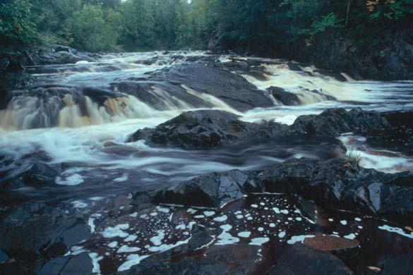
7 Kakagon Sloughs Tyler Forks Dale A. Thomas/NP Studios Tyler Forks Falls Dale A. Thomas/NP Studios Dale A Thomas/NP Studios Tyler Fork Falls Dale A. Thomas/NP Studios 7

8 Conclusion This document gives a short summary of the natural resources that have the potential to be impacted by mining activities in the Penokee Range. It is critical that these unique resources be identified, the threats to them recognized, and all efforts made to protect them. The Nature Conservancy believes there are many questions that need be answered to make sound policy decisions on this issue. What is the exact location and extent of actually strip mine Expansion plan what is the potential scale of this mine 5, 10, 50 years How much water (actual) will this mine use, where will it come from and how will it be returned to the system What will be leached form the exposed rock, how will this be contained from reaching surface and ground water and how will it be treated What impact will this mine have on surface and ground water How does the groundwater move away from this site and what impact will that have on local communities How will the mine impact surface water, quality, quantity, timing and temperature How will this project impact endangered species It is our hope that due diligence is done so that thoughtful and informed decision are made on how to proceed with any mining operation in this area. It is an area of the state that The Nature Conservancy and its partners have been working in for a long time and we hope our experience can help inform good policy decisions on this issue. Howard Moon Caroline Lake, Headwaters to Bad River Gerald H. Emmerich, Jr. Contact: Casey Eggleston The Nature Conservancy 633 W. Main Street Madison, WI ceggleston@tnc.org Gerald H. Emmerich, Jr. 8
Wildlife Introduction
 Wildlife Introduction The wildlife section of this chapter is divided into sections for various habitats and groups of species. Old growth, snags and downed wood, and riparian areas are unique habitats
Overview Open Space and Recreation
 Overview Open Space and Recreation Open Space Plan (2004) Environmental Priority Areas Town Character Priority Areas Recreational Facilities maintained by the Town RSU 21 Recreational Facilities in Kennebunk
What was the historic coaster fishery like?
 1 of 6 1/30/2012 12:25 PM Home About Topics Contact Us Fishing Calendar Fish ID Tips FAQs Hack Noyes Research Vessel Is it a unique strain long lost from Wisconsin's shoreline? Fisheries Reports Tributaries
Black Sturgeon Regional Plan
 Black Sturgeon Regional Plan This is one of twenty Regional Plans that support implementation of the Lake Superior Biodiversity Conservation Strategy (Strategy). The Strategy, prepared and overseen by
JC Mesa Ranch. Colorado - San Miguel County - Telluride
 Commanding stunning views of Telluride and surrounding peaks, the 2,379 deeded-acre JC Mesa Ranch is one of the only remaining undeveloped and unencumbered ranches in the Telluride area. Surrounded by
The Value of Springs to The Petersen Ranch
 The Value of Springs to The Petersen Ranch Location 60 miles SW of Austin 50 miles North of San Antonio 12 miles West of Blanco 18 miles SE of Fredericksburg 8 miles SW of Luchenbach Ranch Overview 800
Executive Summary. Map 1. The Santa Clara River watershed with topography.
 Santa Clara River Steelhead Trout: Assessment and Recovery Opportunities December 2005 Prepared By: Matt Stoecker and Elise Kelley, Ph.D. University of California, Santa Barbara Prepared For: The Santa
Minnesota TREK MINNESOTA TRAIL SELF-GUIDED TOUR 6TH - 8TH GRADE. Minnesota Trek 6 8th grades 1
 Minnesota TREK MINNESOTA TRAIL SELF-GUIDED TOUR 6TH - 8TH GRADE Minnesota Trek 6 8th grades 1 Welcome to the MINNESOTA ZOO Minnesota Trek Self-Guided Tour USE THE MINNESOTA TREK TO HELP YOU LEARN HOW...
Ruffed Grouse Conservation Plan Executive Report
 Ruffed Grouse Conservation Plan Executive Report prepared by Dessecker, Norman and Williamson prepared by Dessecker, Norman and Williamson Ruffed Grouse Conservation Plan Ruffed Grouse Conservation Plan
Minnesota Deer Population Goals
 This document is made available electronically by the Minnesota Legislative Reference Library as part of an ongoing digital archiving project. http://www.leg.state.mn.us/lrl/lrl.asp Minnesota Deer Population
Camelot at Strawberry Pinnacles
 Camelot at Strawberry Pinnacles Your Well-Earned Slice of Paradise Duchesne County, Utah 7.53 Acres $749,000 3616 Elmwood Street, Salt Lake City, UT 84106 801-870-1801 info@landrancher.com Welcome to Camelot
UNDERSTANDING YOUR ESTUARY Level IA- ESTUARY SEARCH
 UNDERSTANDING YOUR ESTUARY Level IA- ESTUARY SEARCH Kakagon/Bad River Sloughs, a Lake Superior estuary located on the Bad River Reservation near Ashland, WI. GOAL Select one Wisconsin estuary to study
The Greater Sage-Grouse:
 The Greater Sage-Grouse: Hunter opinions regarding potential conservation strategies in eleven western states For: National Wildlife Federation October 30, 2014 PO Box 6435 Fernandina Beach, FL 32035 Tel
Designated Trout Stream Additions Arrowhead Creek
 Designated Trout Stream Additions Arrowhead Creek A small reach of Arrowhead Creek was inadvertently left off the list of sections when the stream was originally designated. This designation would fill
YELLOWSTONE RANCH PRESERVE HEBGEN LAKE, MONTANA
 YELLOWSTONE RANCH PRESERVE HEBGEN LAKE, MONTANA PROPERTY OVERVIEW CONTENTS: PROPERTY OVERVIEW...3 CONSERVATION EASEMENT...5 WHISKEY JUG CABIN...6 THE MARINA...7 MAP...8 WILDLIFE...10 YELLOWSTONE REGION...11-3
FOR SALE Sprague River Ranch
 FOR SALE Sprague River Ranch Klamath County, OR 30,620 ± Total acres 15,620 Deeded acres 15,000 Leased acres $23,350,000 The Sprague River Ranch is the quintessential combination of a recreational and
021 Deer Management Unit
 021 Deer Management Unit Geographic Location: Deer Management Unit (DMU) 021 is 1,464 square miles in size and is located in the central Upper Peninsula (UP). This DMU is dominated by publicly owned land
Minnesota Deer Population Goals. East Central Uplands Goal Block
 Minnesota Deer Population Goals East Central Uplands Goal Block Minnesota DNR Section of Wildlife, 2015 Final Deer Population Goals Block 4: East Central Uplands The following pages provide a description
RESTORING 400 ACRES OF TIDAL MARSH IN THE SNOHOMISH RIVER DELTA
 RESTORING 400 ACRES OF TIDAL MARSH IN THE SNOHOMISH RIVER DELTA Marya Moses, Danny Moses, Neil Moses, and Robert Moses fish on Tulalip Bay, near the mouth of the Snohomish River Estuary. QWULOOLT IS A
Minnesota Department of Natural Resources Division of Fish and Wildlife Section of Fisheries. Stream Survey Report. Luxemburg Creek.
 Minnesota F-29-R(P)-24 Area 315 Study 3 March 2016 Minnesota Department of Natural Resources Division of Fish and Wildlife Section of Fisheries Stream Survey Report Luxemburg Creek 2015 Mark Pelham Sauk
no-take zone 1 of 5 Channel Islands National Marine Sanctuary, California
 This website would like to remind you: Your browser (Apple Safari 4) is out of date. Update your browser for more security, comfort and the best experience on this site. Encyclopedic Entry no-take zone
Owyhee Hikes February & April, 2009
 Owyhee Hikes February & April, 2009 I did a 22 mile loop hike along the Snake River at Swan Falls to view petroglyphs and to find locations to fish for Bass, Catfish and Crappie later in the summer. I
Woods Creek Ranch DRIGGS, IDAHO
 Woods Creek Ranch DRIGGS, IDAHO Woods Creek Ranch DRIGGS, IDAHO Introduction: Woods Creek Ranch is a sportsman s paradise located in the heart of Teton Valley, Idaho, less than 3 miles from downtown Driggs
NEVADA DEPARTMENT OF WILDLIFE STATEWIDE FISHERIES MANAGEMENT
 NEVADA DEPARTMENT OF WILDLIFE STATEWIDE FISHERIES MANAGEMENT FEDERAL AID JOB PROGRESS REPORTS F-20-52 2016 REDBAND TROUT EASTERN REGION NEVADA DEPARTMENT OF WILDLIFE, FISHERIES DIVISION ANNUAL JOB PROGRESS
Chagrin River TMDL Appendices. Appendix F
 Appendix F The following are excerpts from the Eastern Brook Trout Joint Venture s Conservation Strategy (Working Draft v.6), Conserving the Eastern Brook Trout: Strategies for Action Found at: http://www.easternbrooktrout.org/constrategy.html
Alberta Conservation Association 2018/19 Project Summary Report. Project Name: North Saskatchewan River Drainage Fish Sustainability Index Data Gaps
 Alberta Conservation Association 2018/19 Project Summary Report Project Name: North Saskatchewan River Drainage Fish Sustainability Index Data Gaps Fisheries Program Manager: Peter Aku Project Leader:
Broken Bar W Ranch TETON VALLEY, IDAHO. Hunting Ranching Fly Fishing Conservation
 Broken Bar W Ranch TETON VALLEY, IDAHO Hunting Ranching Fly Fishing Conservation Broken Bar W Ranch TETON VALLEY, IDAHO Introduction: The Broken Bar W Ranch is located in Driggs, Idaho, the county seat
Conservation Planning in Vermont
 Conservation Planning in Vermont Today s outline 1. A primer on conservation biology 2. VT Wildlife Action Plan 3. How VTRANS & Fish and Wildlife work together 4. Discussion: How can we better work together?
Section 2: Biodiversity at Risk
 Section 2: Biodiversity at Risk Preview Classroom Catalyst Objectives Biodiversity at Risk Current Extinctions Species Prone to Extinction How Do Humans Cause Extinctions? Habitat Destruction and Fragmentation
Franklin County Ranch Hunting, Fishing, Recreation, Cattle Hardwoods, Lakes, Ponds, Waterfowl Habitat, Pastures
 Franklin County Ranch Hunting, Fishing, Recreation, Cattle Hardwoods, Lakes, Ponds, Waterfowl Habitat, Pastures +/- 4,335 Contiguous Acres Janet G. Helm Ranch Broker P.O. Box 399 Van Horn, TX 79855 915-828-3532
EXECUTIVE SUMMARY Feasibility Study on the Reintroduction of Gray Wolves to the Olympic Peninsula
 EXECUTIVE SUMMARY Feasibility Study on the Reintroduction of Gray Wolves to the Olympic Peninsula Prepared by U.S. Fish and Wildlife Service Western Washington Office Introduction Historical records indicate
Wapiti Lodge WAPATI, WYOMING. Hunting Ranching Fly Fishing Conservation
 Wapiti Lodge WAPATI, WYOMING Hunting Ranching Fly Fishing Conservation Wapati Lodge WAPATI, WYOMING Introduction: Nestled in a spectacular setting along the North Fork Highway, the 4.68-acre Wapiti Lodge
7D Ranch & Cattle Companuy 2,544 ACRES FOR SALE IN SAN SABA COUNTY $10,216,000
 7D Ranch & Cattle Companuy 2,544 ACRES FOR SALE IN SAN SABA COUNTY $10,216,000 Location Map DESCRIPTION: 7D Ranch and Cattle Company is a premium 2,544 acre turnkey ranching operation located just north
Attention, taxpayers. There's a
 Nongame Wildlife Calls for Help Pine marten There's something new and wild lurking in of all places! your Minnesota tax forms. Watch for it! Attention, taxpayers. There's a new line on your income tax
1748 The Ohio. a trading post near Piqua to trade items made in England for. in big demand.
 Ohio Wildlife History Timeline 1748 The Ohio Company builds a trading post near Piqua to trade items made in England for furs. Beaver are in big demand. 1770 George Washington mapped Ohio lands given to
Final Review of New Information Appendix E AMPs-Sheep Allotments in Gravelly Mountains. c,llorttarta 'Fisft, MADISON RANGER DISTRICT.
 RECEIVED + MAR 2 2 2017 c,llorttarta 'Fisft, MADISON RANGER DISTRICT J'Wi e 1400 South 19 th Avenue Bozeman MT 59718-5495 March 20, 2017 Dale Olsen Madison Ranger District 5 Forest Service Road Ennis,
Wisconsin s Citizen-Based Monitoring Partnership Program and Trout Unlimited Driftless Area Restoration Effort (TUDARE)
") Wisconsin s 2010-11 Citizen-Based Monitoring Partnership Program and Trout Unlimited Driftless Area Restoration Effort (TUDARE) TUDARE Stream Monitoring Sites Established in 2010-2011 Summary Prepared
Wisconsin s 2010-11 Citizen-Based Monitoring Partnership Program and Trout Unlimited Driftless Area Restoration Effort (TUDARE) TUDARE Stream Monitoring Sites Established in 2010-2011 Summary Prepared
RANCH & FARM SALES PRESENTS. Hunt Mill Hollow Ranch 730 +/- ACRES $1,900 PER ACRE
 SOUTHWEST RANCH & FARM SALES PRESENTS Hunt Mill Hollow Ranch 730 +/- ACRES $1,900 PER ACRE High Fenced, World-Class Oklahoma Hunting & Recreational Ranch. Secluded high in the Ozark Mountains of northeast
PRISTINE. PRIVATE. PERFECT.
 PRISTINE. PRIVATE. PERFECT. A sublime parcel of the American West, Inyanga Ranch consists of over 530 acres of beautiful river frontage, ponds, meadows and historic cabins at the end of a box canyon, protected
Managing Woodlands for Wisconsin s Coastal Trout Streams
 Protecting Water Quality and Stream Habitat 1 in Wisconsin streams in Lake Superior (left) and Lake Michigan (right) watersheds. Watershed boundaries ONE-THIRD OF WISCONSIN S TROUT STREAMS FLOW INTO LAKE
Cat Island Chain Restoration
 Cat Island Chain Restoration 1820s Fox River Military Road Map to Fort Howard 1845 Chart of Green Bay & Fox River Cat Island Chain - 1938 Cat Island Brown County Aerial Photography, 1938 Historic Western
DESCRIBE THE HABITAT REQUIREMENTS AND OTHER FACTORS THAT AFFECT WILDLIFE SPECIES NATURAL RESOURCE I FISHERY AND WILDLIFE MANAGEMENT OBJECTIVE 5.
 DESCRIBE THE HABITAT REQUIREMENTS AND OTHER FACTORS THAT AFFECT WILDLIFE SPECIES NATURAL RESOURCE I FISHERY AND WILDLIFE MANAGEMENT OBJECTIVE 5.03 HABITAT THE BASIC REQUIREMENTS OF FOOD, COVER, WATER,
Teton Darby Ranch TETON VALLEY, IDAHO
 Teton Darby Ranch TETON VALLEY, IDAHO Teton Darby Ranch TETON VALLEY, IDAHO Introduction: The Teton Darby Ranch is the combination of two adjacent ranches, Double Creek Ranch and Broken Bar W Ranch, totaling
Alberta Conservation Association 2007/08 Project Summary Report
 Alberta Conservation Association 2007/08 Project Summary Report Project Name: Provincial Habitat Securement Program Project Leader: Darren Dorge Primary ACA staff on this project: Boreal (NW): Ed Kolodychuk;
FACT SHEET I. LOCATION
 STEAMBOAT ISLAND HABITAT REHABILITATION AND ENHANCEMENT PROJECT (HREP) SCOTT COUNTY, IOWA, UPPER MISSISSIPPI RIVER RESTORATION-ENVIRONMENTAL MANAGEMENT PROGRAM ROCK ISLAND DISTRICT FACT SHEET I. LOCATION
Michigan Dept. of Natural Resources Status of the Fishery Resource Report Page 1. Weber Lake Cheboygan County, T34N, R3W, Sec.
 Michigan Dept. of Natural Resources 2012-143 Status of the Fishery Resource Report Page 1 Weber Lake Cheboygan County, T34N, R3W, Sec. 31 Neal Godby, Fisheries Biologist Environment Weber Lake is a 28.5-acre
Bitch Creek Canyon Ranch
 Bitch Creek Canyon Ranch LAMONT, IDAHO Fly Fishing Hunting Ranching Conservation Bitch Creek Canyon Ranch LAMONT, IDAHO Introduction: Within close driving distance to some of Idaho s most prestigious fisheries,
Water of the Rogue Valley
 Water of the Rogue Valley An Activity Book for Grades 3-5 Welcome! You are about to embark on a journey of exploration. Your adventure begins at school and continues at North Mountain Park. This workbook
Beaver Valley Ranch Steamboat Springs, Colorado
 Beaver Valley Ranch Steamboat Springs, Colorado Introduction Hidden in the heart of one of Colorado s last unspoiled mountain valleys, Beaver Valley Ranch is tailor-made for hunting and fishing of exceptional
Fall River Ranch ASHTON, IDAHO
 Fall River Ranch ASHTON, IDAHO Fall River Ranch ASHTON, IDAHO Introduction: Located in Idaho s wild and scenic Henry s Fork Basin in the heart of the Greater Yellowstone Ecosystem, the Fall River Ranch
Deer Management Unit 252
 Deer Management Unit 252 Geographic Location: Deer Management Unit (DMU) 252 is 297 miles 2 in size and is primarily in southeastern Marquette, southwestern Alger and northwestern Delta County. This DMU
placed on the market.
 With Mimbres River frontage and tremendous grass forage, this jewel in New Mexico s Southern Gila Region is a must have for the discriminating buyer looking to have it all in one easily operated grazing
Teton River Confluence Ranch TETON VALLEY, IDAHO
 Teton River Confluence Ranch TETON VALLEY, IDAHO Teton River Confluence Ranch TETON VALLEY, IDAHO TETON RIVER CONFLUENCE RANCH INTRODUCTION Introduction: Teton River Confluence Ranch possesses that rare
TWO FORKS RANCH A5 REAL ESTATE. 790 Acres. Smiths Fork - Lincoln County - Wyoming
 TWO FORKS RANCH 790 Acres Smiths Fork - Lincoln County - Wyoming A5 REAL ESTATE WWW.A5REALESTATE.COM QUICK FACTS Located in the upper Smiths Fork drainage of Lincoln County, Wyoming, the Two Forks Ranch
6TH PELLETIER BROOK LAKE T15 R9, Aroostook Co. U.S.G.S. Gardner Pond, Maine (7 1/2 )
") 6TH PELLETIER BROOK LAKE T15 R9, Aroostook Co. U.S.G.S. Gardner Pond, Maine (7 1/2 ) Fishes Brook trout Minnows Blacknose dace Pearl dace Physical Characteristics Area - 27 acres Average depth - 2 feet
6TH PELLETIER BROOK LAKE T15 R9, Aroostook Co. U.S.G.S. Gardner Pond, Maine (7 1/2 ) Fishes Brook trout Minnows Blacknose dace Pearl dace Physical Characteristics Area - 27 acres Average depth - 2 feet
White Horse Canyon Ranch
 White Horse Canyon Ranch Modoc County, California Proudly Offered By 707 Merchant Street, Suite 100, Vacaville, Ca 95688 (707) 455-4444 Office (707) 455-0455 Fax info@caoutdoorproperties.com Introduction
North Park Ranch for Sale North Park Ranch for Sale. Double M Ranch Jackson County, CO
 Double M Ranch Jackson County, CO Professionally Developed Trout Fishery and Recreational Ranch Over 2 miles of trophy fishing on the Michigan River One hour from Steamboat Springs Resort Recreational
Deer Management Unit 127
 Deer Management Unit 127 Area Description Deer Management Unit (DMU) 127 is 328 sq. miles in size and is found in far western Gogebic County surrounding Ironwood, Bessemer and adjacent rural communities.
Macutagon Creek to Russell s Landing
 Day Trips Macutagon Creek to Russell s Landing Manitouwadge Public Consultation Committee Canoe Route #13 #13 MACUTAGON CREEK TO RUSSELL S LANDING This route is suitable to all levels of paddlers but due
CHAPTER 4 DESIRED OUTCOMES: VISION, GOALS, AND OBJECTIVES
 CHAPTER 4 DESIRED OUTCOMES: VISION, GOALS, AND OBJECTIVES Vision One of the first steps in developing this Plan was articulating a vision - a clear statement of what the Plan strives to achieve and what
Rebirth of the Pigeon River: Song of the Morning Dam Removal Project
 Major funding for this project was provided by: Michigan Department of Natural Resources Aquatic Habitat Grant Program $293,000 Golden Lotus, Inc. $100,000 Great Lakes Fishery Trust $46,000 Pigeon River
United States Department of the Interior
 United States Department of the Interior FISH AND WILDLIFE SERVICE Green Bay Ecological Services Field Office 2661 SCOTT TOWER DRIVE NEW FRANKEN, WI 54229 PHONE: (920)866-1717 FAX: (920)866-1710 Consultation
Alberta Conservation Association 2017/18 Project Summary Report
 Alberta Conservation Association 2017/18 Project Summary Report Project Name: Abundance, Distribution, Spawning, and Thermal Habitat of Westslope Cutthroat Trout and Bull Trout in the Stimson Creek Watershed
Deer Management Unit 152
 Deer Management Unit 152 Geographic Location: Deer Management Unit (DMU) 152 is 386 miles 2 in size and is primarily in southwestern Marquette County. This DMU falls within the moderate snowfall zone and
Bill Hanson US Fish & Wildlife Service
 Bill Hanson US Fish & Wildlife Service Queen Charlotte Goshawk Photo: Rich Lowell Endangered Species Goals and Purpose of the Endangered Species Act Who Manages the ESA? US Fish and Wildlife Service National
Faler Creek Ranch DANIEL, WYOMING. Fly Fishing Hunting Ranching Conservation
 Faler Creek Ranch DANIEL, WYOMING Fly Fishing Hunting Ranching Conservation Faler Creek Ranch DANIEL, WYOMING Introduction: Faler Creek Ranch is comprised of 91 acres, providing stunning views of the Wyoming
Note: You do not need to be a Wisconsin landowner; we ll consider any woodland owner in the Midwest region.
 COVERTS COOPERATOR APPLICATION for the 2018 Wisconsin Coverts Project Workshop at Kemp Natural Resources Station in Woodruff, WI August 16-19, 2018 We re looking for private landowners who are interested
Climate Change Adaptation and Stream Restoration. Jack Williams;
 Climate Change Adaptation and Stream Restoration Jack Williams; jwilliams@tu.org 1 Goals for this presentation Develop strategies for adapting streams to climate impacts by Thinking like a watershed Understanding
High Uinta Wilderness
 High Uinta Wilderness July 5-7, 2010 Elevation: 10,000 11,000 Grayling, Brook, Cutthroat It was that time of year again to do my annual backpacking/fly fishing trip with my brothers. This year my brothers
WFC 10 Wildlife Ecology & Conservation Nov. 29, Restoration Ecology: Rivers & Streams. Lisa Thompson. UC Cooperative Extension
 Restoration Ecology: Rivers and Streams WFC 10 29 Nov 2010 Restoration of ecosystems often involves creating new systems with only partial resemblance to the original ecosystems Lisa Thompson Fisheries
Ministry of Forests, Lands and Natural Resource Operations
 For Immediate Release 2015FLNR0004-000035 January 15, 2015 INFORMATION BULLETIN Government acting to save endangered caribou VICTORIA - The Ministry of Forests, Lands and Natural Resource Operations is
Michigan Department of Natural Resources Status of the Fishery Resource Report Page 1
 Michigan Department of Natural Resources 2008-59 Status of the Fishery Resource Report Page 1 Bowens Manistee County, (T24N R16W Sec. 11, 12, 13, 14, 15, 24, and 30). Last surveyed 2008 Mark A. Tonello
Rocky Water Ranch 1375+/- Acres Hamilton County, Texas $4,812,500 ($3,500/acre)
") 1375+/- Acres Hamilton County, Texas $4,812,500 ($3,500/acre)! Bret Polk Mobile: (254) 965-0349 Office: (214) 361-9191 LOCATION: The Rocky Water Ranch is located approximately 4 miles South of Hico, Texas,
1375+/- Acres Hamilton County, Texas $4,812,500 ($3,500/acre)! Bret Polk Mobile: (254) 965-0349 Office: (214) 361-9191 LOCATION: The Rocky Water Ranch is located approximately 4 miles South of Hico, Texas,
Deer Management Unit 255
 Deer Management Unit 255 Area Description DMU 255 is located primarily in northern Menominee County, but also extends into a small portion of Dickinson, Marquette, and Delta counties. It has totaled 463
2015 Deer Population Goal Setting
 Deer advisory team recommendations Block 4: East Central Uplands The following pages represent deer population goals recommended by the 2015 deer advisory team for Block 4: East Central Uplands (permit
2012 Wildlife Studies
 2012 Wildlife Studies Prepared by Cardno ENTRIX Agency Meeting on Draft 2012 Study Descriptions December 8, 2011 1 Project Components 2 Project Region ADF&G GMUs 3 Wildlife Studies for 2012 W-S1: Wildlife
*attached below (scroll down)*
*") Mon 4/24 Activities Learning Target Students will review the concepts of chapter 13. Class Activities Play Classroom Jeopardy to review for test ---work on Chapter 13 review (due Tue) *attached below (scroll
Mon 4/24 Activities Learning Target Students will review the concepts of chapter 13. Class Activities Play Classroom Jeopardy to review for test ---work on Chapter 13 review (due Tue) *attached below (scroll
Lazy K Ranch DRIGGS, IDAHO. Hunting Ranching Fly Fishing Conservation
 Lazy K Ranch DRIGGS, IDAHO Hunting Ranching Fly Fishing Conservation Lazy K Ranch DRIGGS, IDAHO Introduction: Ideally situated in the heart of Teton Valley, Idaho, the Lazy K Ranch is 3 miles from downtown
2.0 GENERAL DESCRIPTION OF RED LAKE WATERSHED DISTRICT
 2.0 GENERAL DESCRIPTION OF RED LAKE WATERSHED DISTRICT 2.1 LOCATION AND SIZE The RLWD is located in northwestern Minnesota and includes all of Red Lake County and parts of the following counties: Beltrami,
Video zone How wolves change rivers
 Video zone How wolves change rivers Tasks Instructions Do the preparation task first. Then watch the video and do the exercise. You can also read the transcript. Preparation task Match the definitions
Wisconsin Lake Superior Basin Brook Trout Plan
 Wisconsin Lake Superior Basin Brook Trout Plan A Joint Plan Between Wisconsin Department of Natural Resources & U.S. Fish and Wildlife Service May 2005 1 Executive Summary Brook trout (Salvelinus fontinalis)
Copyright 2018 by Jamie L. Sandberg
 Copyright 2018 by Jamie L. Sandberg All rights reserved. This book or any portion thereof may not be reproduced or used in any manner whatsoever without the express written permission of the publisher,
DMU 008 Barry County Deer Management Unit
 DMU 8 Barry County Deer Management Unit Area Description The Barry County Deer Management Unit (DMU) 8 is in the Southwest Region and was once part of the Bellevue deer management unit 38. Bellevue DMU
Importance of un-named tributary streams to Brook Trout populations. Dr. Jonathan M. Niles Dr. Dan Ressler
 Importance of un-named tributary streams to Brook Trout populations. Dr. Jonathan M. Niles Dr. Dan Ressler Pennsylvania Streams All streams of PA have a designated use - Huge resource - 8,011 named tributaries:
SCIENCE AND TECHNOLOGY: CANADA COAST TO COAST
 ACTIVITY DESCRIPTION: This activity shows the abundance of water in and around Canada. By identifying and labeling a number of water bodies and courses, students realize the magnitude of Canada s water
1. What is the National Wildlife Refuge System? 2. Who started the National Wildlife Refuge System? When?
 Honors Biology ANWR Scored Discussion Prep Handout 1 Source: US Fish and Wildlife Service / ANWR Name: Purpose: The purpose of this handout is to help you research some of the basic facts regarding the
DMU 038 Jackson County
 DMU 038 Jackson County Area Description The Jackson Deer Management Unit (DMU), or DMU 038, lies in the Southern Lower Peninsula (SLP) region and covers Jackson County. The DMU consists of five percent
EXECUTIVE SUMMARY. Ontonagon River Assessment
 EXECUTIVE SUMMARY This river assessment is one of a series of documents being prepared by Michigan Department of Natural Resources (MDNR), Fisheries Division, for Michigan rivers. This report describes
Wind Rock Ranch DUBOIS, WYOMING
 Wind Rock Ranch DUBOIS, WYOMING Wind Rock Ranch DUBOIS, WYOMING Introduction: The Wind Rock Ranch is located in Fremont County, Wyoming, six miles south-east of the town of Dubois, WY. The ranch headquarters
Western Great Lakes Region FAN UPDATE
 From: Gary Zimmer [mailto:rgszimm@newnorth.net] Sent: Friday, October 29, 2010 3:51 PM To: FAN Member Subject: FAN Update Western Great Lakes Region FAN UPDATE Volume 10, Issue 3 October 25, 2010 CALL
TRCP National Sportsmen s Survey Online/phone survey of 1,000 hunters and anglers throughout the United States
 #17144 TRCP National Sportsmen s Survey Online/phone survey of 1,000 hunters and anglers throughout the United States Methodology Public Opinion Strategies conducted a national survey of N =1,000 voters
PASSENGER RAIL STATION LOCATION AND DESIGN WORKING GROUP MEETING STOCKBRIDGE
 PASSENGER RAIL STATION LOCATION AND DESIGN WORKING GROUP MEETING STOCKBRIDGE Criteria for Passenger Rail Station Location Municipal Level To objectively compare Target Areas in all communities along the
Circle W Ranch SPRAY, OREGON. Hunting Ranching Fly Fishing Conservation
 Circle W Ranch SPRAY, OREGON Hunting Ranching Fly Fishing Conservation Circle W Ranch SPRAY, OREGON CIntroduction The Circle W Ranch is located in North Central Oregon. The North border of the ranch runs
Over 130 Environmental Groups Oppose Deep Cuts to Environment and Natural Resources Programs in the President s FY18 Budget Proposal
 Over 130 Environmental Groups Oppose Deep Cuts to Environment and Natural Resources Programs in the President s FY18 Budget Proposal March 16, 2017 Dear Senator/Representative: On behalf of our millions
Call for more informa on
 43.4 acres 659 feet road front Fronts Dill Brook Power Phone Mountain Views Lakes The Bottle Lake Forest has 43.4 surveyed acres with year round access on a paved road with electric and phone at the street.
The Calawah River System
 The Calawah River System The Calawah River is the largest tributary of the Bogachiel River and is formed by the confluence of the north and south forks of the Calawah. The two forks of the Calawah, CALAWAH
Introduction to Pennsylvania s Deer Management Program. Christopher S. Rosenberry Deer and Elk Section Bureau of Wildlife Management
 Introduction to Pennsylvania s Deer Management Program Christopher S. Rosenberry Deer and Elk Section Bureau of Wildlife Management To anyone who has carefully studied the situation it is evident that
DOWNLOAD OR READ : GAME AND FISH LAWS OF THE STATE OF LOUISIAN PDF EBOOK EPUB MOBI
 DOWNLOAD OR READ : GAME AND FISH LAWS OF THE STATE OF LOUISIAN PDF EBOOK EPUB MOBI Page 1 Page 2 game and fish laws of the state of louisian game and fish laws pdf game and fish laws of the state of louisian
Creation of Fish and Wildlife Habitat on the Closed Salmon Harbour Mine in Minto, NB
 Creation of Fish and Wildlife Habitat on the Closed Salmon Harbour Mine in Minto, NB M. Coleman 1, R. Rutherford 2, RA Currie 3 1 NB Power 2 Thaumas Environmental Consultants Ltd 3 RA Currie Ltd. Location
Species at Risk. Provincial Government Overview. September 13 rd, Kendra Morgan, R.P.Bio.
 Species at Risk Provincial Government Overview September 13 rd, 2017 Kendra Morgan, R.P.Bio. Environmental Biologist Fish & Aquatic Wildlife Resources Resource Management, MFLNRO (South Coast) Outline