Presence/Absence of Lake Utopia Rainbow Smelt (Osmerus mordax) Large-bodied Population and Small-bodied Population
|
|
|
- Buddy Lyons
- 5 years ago
- Views:
Transcription
1 Maritime Aboriginal Peoples Council IKANAWTIKET Environmental Incorporated Presence/Absence of Lake Utopia Rainbow Smelt (Osmerus mordax) Large-bodied Population and Small-bodied Population April May 2014 Spawning Run Field Study September 30, 2014 Joshua McNeely*, IKANAWTIKET, 172 Truro Heights Road, Truro Heights, NS, Canada B6L 1X1, , Barry LaBillois, MAPC-MAARS, 528 Route 8 Highway, Durham Bridge, NB, Canada E6C 1K5, , blabillois@mapcorg.ca
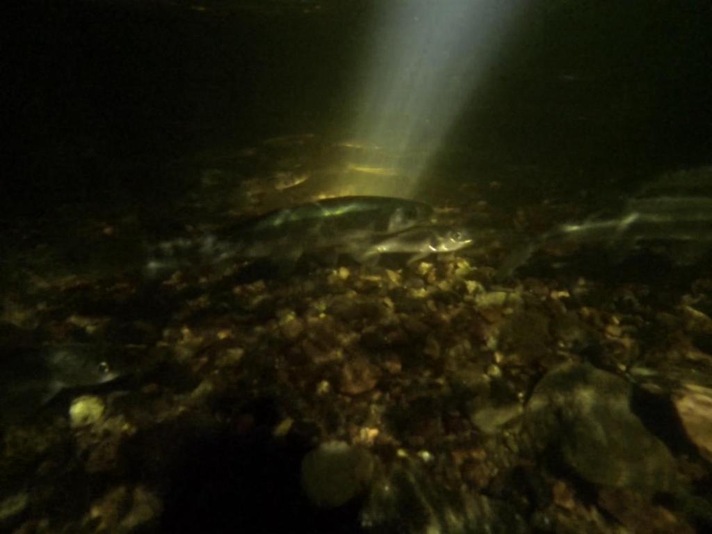
 Spawning with Large-bodied form on Mill Lake Stream, Lake Utopia.")
2 Front Cover Lake Utopia Rainbow Smelts, Large-bodied Form (top) and Small-bodied Form (bottom). Illustrations by Diana McPhail. Taken from COSEWIC, Back Cover Lake Utopia Rainbow Smelts, Giant-bodied form (image center) Spawning with Large-bodied form on Mill Lake Stream, Lake Utopia. Time-Series of four images taken from video by Andy Seeley on April 6, , IKANAWTIKET Environmental Incorporated 172 Truro Heights Road Truro Heights Nova Scotia, Canada B6L 1X1 Tel: Fax: Web: 2
3 Abstract From April 1 to May , the Maritime Aboriginal Peoples Council completed a dedicated presence/absence spawning survey of the sympatric pair of Lake Utopia Rainbow Smelt (LURS) (Osmerus mordax), Large-bodied Population (LbP) and Small-bodied Population (SbP) on historic spawning tributaries of Lake Utopia in Southern New Brunswick. This project was a continuation of a similar project undertaken by the New Brunswick Aboriginal Peoples Council in The projects were jointly developed between the Maritime Aboriginal Peoples Council-Maritime Aboriginal Aquatic Resources Secretariate, IKANAWTIKET Environmental Incorporated, the New Brunswick Aboriginal Peoples Council, and the Department of Fisheries and Oceans Canada-Maritimes Region Species at Risk Office. This survey work also continues a working partnership between the organizations with the aim to continue, over the next few years, a series of dedicated field studies to daily note the presence or absence of LURS spawners which would be useful for the next LURS population assessment, as well as to provide some enumeration survey data (since the presence/absence survey also included rough visual estimates of nightly spawner abundance) to ground-truth the draft Recovery Strategy (March, 2013). For 2014, the project was formalized via a DFO Purchase Order Contract F The study found a total of 16,036 LURS-LbP spawning on Mill Lake Stream from April 1-8, though none were found on Trout Lake Stream. The Summation of the 5 Highest Daily Estimates was 15,750, which was more than 7 ½ times that required to meet the proposed population abundance objective of the draft Recovery Strategy. Fork length measurements were opportunistically observed and it was noted that the average length of LURS-LbP spawners (excluding giant-body form ) were at the extreme low end (~17 cm) of the size range suggested in the draft Recovery Strategy. Unfortunately, weather conditions and high, turbid water prevented LURS-SbP surveys for most of the peak spawning period from late-april to early May. Small numbers of a few hundred each were recorded on Unnamed Brook and Smelt Brook, as well as eggs from previous spawning, during the first week of May. The metric of the Summation of the 5 Highest Daily Estimates for LURS-SbP on Second Brook, Unnamed Brook, and Smelt Brook could not be calculated due to the lack of data. For the second year in a row, LURS-SbP were recorded on Mill Lake Stream. 7,000 spawners were recorded on April 13 th, which brings into question the use of Mill Lake Stream as spawning habitat for LURS-SbP. 3
4 Six key recommendations were proposed for future study: 1. LURS-LbP spawning should be observed annually for at least the next 3-4 years to confirm that the draft Recovery Strategy abundance objective is being met. 2. LURS-LbP should be located and enumerated at times other than spawning, if possible, to confirm that spawning abundance is an appropriate measure of overall population abundance. 3. A mathematical formula should be developed for estimating LURS-LbP fecundity based on length or weight of spawning females and potential spawning success should be estimated as part of future studies. 4. Mill Lake Stream should be monitored as part of the overall monitoring for LURS-SbP spawning, i.e., included with Smelt Brook, Unnamed Brook, and Second Brook surveys. 5. The Critical Habitat component for LURS-SbP should be re-evaluated to include Mill Lake Stream as a spawning stream Critical Habitat. 6. Work should continue to gain access to the LURS-SbP historic spawning streams of Smelt Brook, Unnamed Brook, and Second Brook during the spawning season in order to enumerate LURS-SbP and understand their behaviour and possibly why LURS-SbP may be utilizing Mill Lake Stream. Four additional recommendations were presented for consideration: 7. More thought should be given to the schooling/massing nature for LURS at specific fish passageways and spawning habitat when designing surveys or projects. As was noted, in some instances, schools will stop and in others they will proceed with migration. Until their spawning migratory behaviour is more fully understood, a precautionary approach should be used. 8. A greater emphasis should be placed on threats at a very localized level and more work should be done to survey and improve stream habitat for back-up or secondary spawning locations, in the case that one of the historic spawning sites is lost. 9. Work should continue to validate presence/absence survey results, for example by seining, photographic/video verification of numbers counted, or by mark-recapture methods. The last method may be useful for also helping to determine actual numbers in years when spawning migration is highly pulsed, like in Given that spawning can occur quickly and in unfavourable conditions for field technicians, environmental variables, including moon cycle, should be monitored in order to better understand the cue(s) that initiate spawning migration, so that survey effort is most effective. Partially as a result of this project and the 2013 presence/absence survey, MAPC-MAARS and IKANAWTIKET have gained additional technical and knowledge capacity to undertake a continued presence on Lake Utopia for future LURS spawning runs, provided that funding is available. In addition, MAPC has indicated that it will undertake a leadership role for LURS in the areas of monitoring surveys, watershed planning, and educational/outreach activities, which has been noted in the draft recovery implementation schedule for inclusion in the draft Action Plan currently under development. 4
 (LURS) as well as give a status update as to the growing working relationship between the Department of Fisheries and Oceans Canada (DFO) Maritimes Region Species at Risk Office and MAPC")
5 Introduction This publication is the second in a series produced by the Maritime Aboriginal Peoples Council IKANAWTIKET to report on the spawning runs of the Lake Utopia Rainbow Smelt (Osmerus mordax) (LURS) as well as give a status update as to the growing working relationship between the Department of Fisheries and Oceans Canada (DFO) Maritimes Region Species at Risk Office and MAPC regarding LURS conservation. The introduction and methods recap and update those laid out in the 2013 report, while the results section presents the data for the 2014 spawning season. The report s conclusions looks at both the 2014 spawning run and also highlights similarities or differences to the 2013 spawning run. LURS is a rainbow smelt, consisting of two genetically diverging body forms or populations, consisting of a Large-bodied or normal/giant form (LbP) and a Small-bodied or dwarf form (SbP), which is endemic to Lake Utopia and associated water bodies on the Magaguadavic River system in southwestern New Brunswick (45 10 N, W) (COSEWIC, 2008) (Figure 1). Figure 1: Lake Utopia, New Brunswick (taken from DFO, 2011). 5
6 LURS is a unique smelt being both: 1) obligative potadromous (meaning it can only migrate within freshwater to spawn, unlike other smelt populations which migrate from salt water to freshwater to spawn; LURS being obligative due to barriers preventing migration to salt water); and 2) a sympatric pair of body forms/populations (meaning the two body forms/populations act as separate species but are still dependent on each other for maintaining each other s distinctiveness ). Thus, not only have LURS become genetically distinct from other nearby rainbow smelt populations as a result of their geographic isolation, the sympatrically paired species itself is also rapidly undergoing the process of speciation into two distinct species whilst still occupying the same habitat. This is a phenomenon which only occurs in a few other cases amongst smelt in North America (COSEWIC, 2008). The uniqueness and endemicity of LURS has prompted the Committee on the Status of Endangered Wildlife in Canada (COSEWIC) to assess each body form as a separate Designatable Unit (DU) LURS Large-bodied Population (LURS-LbP) and LURS Small-bodied Population (LURS- SbP). Each was assessed in 2008 as Threatened (COSEWIC, 2008). Currently only LURS-SbP (previously referred to as the Lake Utopia Dwarf Smelt) is Listed under Schedule 1 of the federal Species at Risk Act (SARA); though the draft SARA Recovery Strategy prepared by DFO addresses both DUs as a sympatric pair (DFO, 2013). A SARA Listing has been proposed for LURS-LbP as of Species population data collection and habitat projects for LURS which are undertaken by MAPC are for the benefit of both DUs. Both COSEWIC and DFO have noted the high level of uncertainty with existing population abundance data, as little attention has been paid to undertaking dedicated LURS population surveys in the past. Current population estimates are derived mainly from data which had been gathered opportunistically during LURS genetic studies (COSEWIC, 2008; DFO, 2013). The March 2013 draft SARA Recovery Strategy proposes an interim 5-year abundance objective of 100,000 spawning LURS-SbP and 2,000 spawning LURS-LbP. The draft Recovery Strategy also proposes an interim 5-year distribution objective of maintaining LURS-SbP spawning on the frequently noted spawning sites on Second Brook, Unnamed Brook, and Smelt Brook and maintaining LURS-LbP spawning on the one frequently noted spawning site on Mill Lake Stream (DFO, 2013). Lake Utopia is within the traditional ancestral homeland territories of the Mi kmaq, Maliseet, and Passamaquoddy Peoples, who continue to enjoy treaty liberties to fish throughout all their traditional ancestral homeland territories as usual extended to their heirs and to the heirs of their heirs, forever (Gould & Simple, 1980; NCNS, 1993). The New Brunswick Aboriginal Peoples Council (NBAPC), represents Aboriginal Peoples continuing on their traditional 6
7 ancestral homeland territories (i.e., living off-reserve) throughout modern day New Brunswick. NBAPC maintains a treaty liberty natural life harvesting regime for its members, as well as, annually negotiates a community-level food, social, and ceremonial (FSC) harvest arrangement with DFO under the DFO Aboriginal Fisheries Strategy (NBAPC, 2009). Aboriginal Peoples holding an eco-centric worldview have long expressed concern about habitats and species, which in some ways parallel the interdependent struggle of Aboriginal Peoples for international, national, and local recognition of Aboriginal Peoples rights to lands, waters, and resources and for all of humanity to respect Mother Earth. In the Maritimes Region, Aboriginal Peoples have continued to advocate for species and habitat protection and the protection of Aboriginal and Treaty Rights since before SARA was passed in 2001 (McNeely and Hunka, 2011). MAPC is the intergovernmental leaders forum of the New Brunswick Aboriginal Peoples Council, the Native Council of Nova Scotia, and the Native Council of Prince Edward Island, which advocates for the Mi kmaq/maliseet/passamaquoddy Aboriginal Peoples living on traditional ancestral homeland territories throughout the Maritimes Region (MAPC, 2014). MAPC established the Maritime Aboriginal Aquatic Resources Secretariate (MAPC-MAARS), which is a technical advisory body to the Aboriginal Communal Commercial Fisheries Entities of the three partner Native Councils, to collectively advance the rightful share to Atlantic aquatic resources and aquaculture operations for the sustained, viable economic growth of the Maritime Aboriginal Peoples. IKANAWTIKET Environmental Incorporated is a Registered Charity to promote the preservation of the natural environment by educating and informing the public about environmental issues and biodiversity in the Maritime Provinces, and Aboriginal culture, worldviews, and knowledge in relation to the environment (MAARS, 2013). MAPC-MAARS and IKANAWTIKET continues to advocate for the respect of Mother Earth and respect of Aboriginal, Treaty, and Other Rights through detailed responses to federal and provincial government departments concerning on-going work to develop national SARA policies, SARA Listing recommendations, and recovery planning documents, as well as through educational initiatives and supporting community conservation efforts (McNeely & Hunka, 2011; Hunka & McNeely, 2012). In , NBAPC expressed concern about the status of LURS, as well as the on-going history of the continued slow derogation of Aboriginal and Treaty Rights. NBAPC, in partnership with MAPC-MAARS and IKANAWTIKET, proposed a range of options to DFO- Maritimes to accommodate mutual interests of protecting LURS and respecting Aboriginal, Treaty, and Other Rights; of which, one item proposed was new avenues of government support for NBAPC to undertake additional research and a stewardship lead on LURS (Nash- McKinley and McNeely, 2012). Together NBAPC, MAPC-MAARS, and IKANAWTIKET approached DFO in 2013 to undertake a species at risk project to provide some base-line data to inform both the proposed SARA Listing and Recovery Strategy processes for LURS. The parties agreed to undertake a dedicated 7
8 (though limited in effort) presence/absence survey of LURS during the spawning run of late winter/early spring The results of the 2013 spawning run are presented in the IKANAWTIKET report Presence/Absence of Lake Utopia Rainbow Smelt (Osmerus modax) Large-bodied Population and Small-bodied Population: March-May 2013 Spawning Run Field Study. DFO and MAPC renewed their commitment in March 2014 to undertake a similar presence/absence survey for the April-May 2014 spawning run. It was also agreed that both would work together to coordinate for a DFO-led team to undertake a mark-recapture survey of the LURS-LbP, something which was recommended in the 2013 report. In addition to the two projects described above, MAPC-MAARS-IKANAWTIKET have undertaken LURS habitat projects in 2013 and 2014 funded through the Aboriginal Funds for Species at Risk. As a result of the community s interest in LURS conservation and sustainable use, and the capacity which is being built as a result of these projects, MAPC agreed to take on several leadership and partnership roles for the LURS Action Plan, including: a) annually estimating spawner abundance b) annually monitoring streams for the presence/absence of LURS c) identifying attributes of Critical Habitat, including areas that support spawning, and identifying areas which could be Critical Habitat or spawning areas d) habitat restoration activities e) watershed planning f) general and specific educational and awareness activities In addition to providing raw data for LURS assessment purposes, projects such as this spawning run assessment increases MAPC s overall capacity to undertake on-the-water projects. Thus, an anticipated, though not detailed in this project s Purchase Order arrangement, is a continued building of a working relationship between MAPC and DFO on LURS conservation and sustainable use. Methods MAPC hired two NBAPC community members living near Lake Utopia to survey the known frequented spawning locations for LURS each day/night, weather permitting, during the spawning period of early April to mid-may in order to capture the five highest days/nights of spawner abundance, which is the standardized data set useful for the Recovery Strategy. For the purposes of this report, the two community members are referred to as field technicians ; however, it should be understood that neither has any formal training in conducting species assessments. One of the community members worked on the project last year and they have field experience, while the other one was new to the project. The technicians were supported by MAPC-MAARS and IKANAWTIKET personnel with training and 8
9 experience using presence/absence surveys; and the flexibility of the project allowed for a learning curve. Thus the project was multi-purpose of providing data and increasing technical capacity, though from a strictly technical aspect of the DFO contract, only data and data analysis were required as deliverables. The streams surveyed for the presence/absence of LURS-LbP were: Mill Lake Stream and Trout Lake Stream and for LURS-SbP were: Mill Lake Stream, Trout Lake Stream, Spear Brook, Second Brook, Unnamed Brook, and Smelt Brook. GPS coordinates and descriptions of the survey sites and spawning areas are contained in Tables 3 & 4 in Appendix A, which also includes reference photographs (Figures 3-5) of the Mill Lake Stream spawning habitat and water conditions for Also provided for reference in Appendix A are drawings of: Fig. 7, the lower portion of Mill Lake Stream and Fig. 8, lower portion of Unnamed Brook; including noted spawning locations and important features. The field technicians noted the presence or absence of LURS-LbP and LURS-SbP, as well as the time of day, effort (in hours), and estimated the number of spawners by visual counting/ extrapolating methods. If the survey took place during the night and extended past mid-night, the date reported is that for the beginning of the survey. Learning from the previous year, new field data sheets were developed to more accurately track the activities of the crew and counts throughout the course of a night. Thus, the data provided in this 2014 report is a somewhat finer scale of information than just total nightly abundance, which was reported in In addition to reporting total nightly abundance, the 2014 data was collected at 30 minute to 1 hour intervals when possible, using a 5 minute or 15 minute walkthrough snapshot (depending on survey location) to estimate abundance. During the remainder of the interval, the activity of the spawners was closely monitored to determine what portion of the group had migrated in or out of the stream since the last snapshot. Thus the data was reported as total number of new spawners for each snapshot, and tabulated to determine nightly abundance. This study did not have the objective to measure lengths of LURS, nor to capture LURS for any reason; however, because field technicians did observe that the LURS-LbP seemed to be abnormally small compared to the length range suggested in the draft Recovery Strategy, the field technicians did take opportunistic length measurements. Since, the field technicians did not have a DFO permit to remove LURS-LbP for accurate measurements, the method employed was to hold a ruler next to a resting fish and visually estimate its fork length, without removing the fish from the water. Though there are obvious limitations with such opportunistic measurements, such errors should be on the side of reading length measurements which are larger than the actual fish, e.g., light refraction through water produces a larger image. It is important to note that the most often recommended method for identifying the body-form populations of LURS (Large-body form and Small-body form) is the length of the fish. The draft Recovery Strategy recommends that size classification is the most useful and practical criteria for general description, though other distinctive morphological and genetic characteristics 9
10 exist. Based on the 2011 DFO Recovery Potential Assessment, the draft Recovery Strategy classifies LURS-SbP as less than 170 mm fork length and LURS-LbP as equal to or greater than 170 mm fork length. However, the COSEWIC Status Report, based on older information, suggests that the fork length division between LURS-SbP and LURS-LbP is much lower (150 mm). A clear definition is important for reasons which will be seen in the results of this report concerning the observed average length of LURS-LbP. Results LURS-LbP As per the DFO Purchase Order, surveys began on April 1, The first instance of spawning was recorded on that night at Mill Lake Stream (3,000 spawners). Checks continued each night on Mill Lake Stream through until April 9 th (0 spawners). Peak spawning activity occurred between April 1-7, but with unexpected lows on April 3 rd (270 spawners) and 4 th (8 spawners). Water conditions precluded surveys on April 10 th and 11 th. A follow-up on the 12 th did not find any LURS-LbP. Trout Lake Stream was also checked daily throughout this time period and LURS- LbP were absent (Table 1). A total of 16,036 LURS-LbP spawners were observed on Mill Lake Stream over an 8 day period in which spawners were observed from April 1 to April 8. The peak spawning abundance was 4,000 on April 6 th. The five highest daily summations of spawner abundance were: Apr. 1 (3,000), Apr. 2 (3,000), Apr. 5 (2,750), Apr. 6 (4,000), and Apr. 7 (3,000), for a total of 15,750 (Figure 2). Table 1: Enumeration of LURS-LbP on Mill Lake Stream (MLS) and Trout Lake Stream (TLS) (hashed cells) during the 2014 spawning run Date Stream Start Effort Visual Estimate Time (hrs) Observed Change Daily Total MLS 20: MLS 21: MLS 22: MLS 23: TLS 1: MLS 21: TLS 22: MLS 22: MLS 23: TLS 23: MLS 2: MLS 21: MLS 22: MLS 23: MLS 0:
11 Table 1 (cont.): Enumeration of LURS-LbP on Mill Lake Stream (MLS) and Trout Lake Stream (TLS) (hashed cells) during the 2014 spawning run Date Stream Start Effort Visual Estimate Time (hrs) MLS 1: MLS 21: MLS 22: MLS 22: MLS 23: MLS 0: MLS 21: MLS 22: TLS 23: MLS 0: MLS 1: MLS 1: MLS 5: MLS 6: MLS 22: MLS 23: MLS 0: MLS 0: MLS 1: MLS 1: MLS 2: MLS 3: MLS 4: MLS 4: MLS 5: MLS 21: MLS 21: TLS 21: MLS 22: MLS 22: MLS 23: MLS 23: MLS 23: MLS 21: TLS 22: MLS 22: MLS 23: MLS 1: MLS 21: TLS 22:
12 Table 1 (cont.): Enumeration of LURS-LbP on Mill Lake Stream (MLS) and Trout Lake Stream (TLS) (hashed cells) during the 2014 spawning run Date Stream Start Effort Visual Estimate Time (hrs) MLS 22: MLS 23: MLS 1: MLS 11: TLS 15: Total MLS 16,076 Total TLS 0 Although the purposes of this study did not include the measurement of lengths of LURS and given the limitations of the opportunistic measurements which were taken, as well as the belief that such measurements would produce an error of overestimating size, it is worthy to note that the observed average for an estimated ¾ of LURS-LbP was 17 cm fork length. This would place the fork length of the 2014 spawning run of LURS-LbP at the extreme low end of the length scale (using the DFO, 2011 criteria). LURS-SbP The issue of safely gaining access to the known LURS-SbP spawning streams, namely Second Brook, Unnamed Brook, and Smelt Brook, was not resolved prior to the start of the LURS-SbP spawning run. A combination of cold temperatures and snow kept ice on the lake well into April. This was followed by an extended period of rapid rise in temperature, rain, and gusty wind conditions during the second week of April which, although clearing the lake of ice, still made it dangerous for night-time small boat passage. Water-levels increased dramatically during the second week of April, up to 3 feet in the lake and over the tops of the culverts on Mill Lake Stream. The water levels remained high throughout the end of April and were highly turbid which made stream-side counting impossible. The result was that Second Brook, Unnamed Brook, and Smelt Brook could only be checked for spawning activity on two nights (May 2 and May 9), which likely coincided with the tail end of the spawning run for LURS-SbP. Mill Lake Stream was opportunistically observed on April 13 th, during which 7,000 LURS-SbP spawners were counted. Mill Lake Stream was again opportunistically observed more than a week later and low numbers of LURS-SbP spawners were still present. 20 LURS-SbP were collected on Mill Lake Stream on April 13 th and sent to the DFO St. Andrews Biological Research Station for identification confirmation via gill raker count and/or genetic analysis (Figure 6). Spear Brook and Otter Brook were also intermittently checked when weather conditions were favorable, but no spawning activity was noted. The limited data is presented in Table 2 and Figure 2. 12
13 Table 2: Enumeration of LURS-SbP on Mill Lake Stream (MLS), Trout Lake Stream (TLS), Second Brook (SCB), Unnamed Brook (UNB), and Smelt Brook (SMB) during the 2014 spawning run. Date Stream Start Time Effort (hrs) Visual Estimate Observed Change Daily Total SCB 12: UNB 13: SMB 14: TLS 15: MLS 18: MLS Poor water conditions MLS Poor water conditions MLS 10: MLS 11: MLS 13: MLS Poor water conditions MLS Poor water conditions MLS 11: SCB 14: UNB 15: SMB 18: TLS 18: MLS 19: UNB 20: UNB 23: MLS Poor water conditions Total SCB 0 Total UNB 130 Total SMB 300 Total MLS 7,070 Total TLS 0 13
14 Lake Utopia Rainbow Smelt Spawner Count LbP, MLS SbP, MLS SbP, UNB SbP, SMB Figure 2: Lake Utopia Rainbow Smelt Spawner Count from Apr. 1-May 9, LbP = Large-bodied Population; SbP = Small-bodied Population; MLS = Mill Lake Stream; UNB = Unnamed Brook; SMB = Smelt Brook. As with the LURS-LbP, and in the same manner as stated above, the field technicians also opportunistically measured the length of LURS-SbP. The observed average fork length for an estimated ¾ of the LURS-SbP on Mill Lake Stream was 9-12 cm. Large-bodied v. Giant-bodied This study counted 30 Giant-bodied LURS (greater than 30 cm total body length) spawning amongst the LURS-LbP on Mill Lake Stream. These were included within the counts for LURS- LbP. Photographs and video were taken (e.g., back cover of this report) which show the significant size difference between the Large-bodied form and Giant-bodied form. However, without counting gill rakers or measuring other morphological or genetic characteristics, this study cannot comment further as to the significance of these Giant-bodied form individuals. Video evidence taken on April 6 th shows the Giant-body form and Large-body form spawning with each other on Mill Lake Stream. 14
15 Conclusion & Discussion Spawner Abundance It is believed that this 2014 study captured the majority of the spawning run for LURS-LbP. Therefore an observed estimation is given, unlike for the 2013 study which only proposed a conservative estimate given that key survey dates were missing. The 5 Highest Daily Summations of LURS-LbP Spawner Abundance was 15,750. The abundance of more than 7 ½ times higher than considered necessary lends some credit to the conservative estimate proposed in 2013 of at least 2,600 to 5,500 LURS-LbP spawners. In fact, the 2014 observation alone is high enough to, by itself, meet the draft Recovery Strategy Performance Measure #6: The average of the yearly means [for a 5-year period] of the 5 highest daily summations of the spawner abundance in Mill Lake Stream over the spawning period is no less than 2,000 individuals. During several nights of LURS-LbP Presence/Absence survey work of this study, DFO conducted a separate LURS-LbP Mark/Recapture survey. Though the results of that study are not presented here, it is worthy to note that the ability of this study s Presence/Absence survey team to visually count LURS, closely matched the DFO Mark/Recapture team s ability to capture LURS with nets (which is detailed below). It is suggested that both studies data be compared for evaluating spawner abundance. It is believed that a majority of the LURS-SbP run was missed due to unfavourable weather conditions, high water, and turbidity throughout most of the spawning run, making stream-side visual counting impossible. For a visual comparison of high and low water conditions on Mill Lake Stream please refer to Figure 5 in Appendix A. A few hundred LURS-SbP were counted on Smelt Brook and Unnamed Brook on May 2 nd, which was believed to be the end of the run due to the presence of eggs from previous spawning. However, an unexpectedly large count of LURS-SbP (7,000) was made during an opportunistic survey of Mill Lake Stream on the night of April 13 th. This was unexpected, because, as noted in the 2013 report, LURS-SbP are not known for choosing Mill Lake Stream for spawning. In fact, spawning Critical Habitat for LURS-SbP in the draft Recovery Strategy is restricted to Smelt Brook, Unnamed Brook, and Second Brook. Second, the large number of spawners on Mill Lake Stream came only four days after a night-time observation of zero and six days after the last LURS-LbP spawners were observed. The event was also several days before the expected beginning of the LURS-SbP spawning run on the historic spawning brooks. Unfortunately, Mill Lake Stream was not routinely monitored between April 9-12 and water conditions after the 13 th prevented survey work. It is unknown whether the 7,000 LURS-SbP counted in Mill Lake Stream on April 13 th was part of a longer-term spawning run on Mill Lake Stream, a result of preference switching due to some unknown factor(s) in the other noted spawning streams, or a random event. If the former, the spawning component on Mill Lake Stream would be the earliest of the LURS-SbP spawners and suggests that there may be a 15
16 shorter period for the widely accepted temporal separation which is, in part, used to characterize the two DUs. If the later, what factor(s) are contributing to LURS-SbP selection of Mill Lake Stream as a spawning stream? Characteristics of Spawning Runs LURS-LbP on Mill Lake Stream never migrated above the culverts and 100% spawning for 2014 took place within 85 feet below the culverts. This is in contrast to 2013 when 100% of the spawning was above the culverts. It is likely that this was due to lower water conditions during the 2014 spawning run for LURS-LbP as compared to In fact, during the 2014 LURS-LbP spawning run, the water level in Mill Lake Stream was low enough that no water ran through the small culvert on the north side of the stream. The team observed that even though water levels were high enough for fish to transit the large culvert on the south side of the stream, they chose not to, instead opting to mass at the lower end of the culvert. As noted earlier, the water-levels were much higher toward the end of April-early May, during the LURS-SbP spawning run. On the few days that Mill Lake Stream was surveyed for LURS-SbP, water-levels were high enough for water to pass through both culverts. In this case, LURS-SbP did pass through both culverts and 100% of the LURS-SbP spawning took place above the culverts. It has been widely stated that smelt will migrate as far as possible upstream and spawn in mass below a natural barrier. However, others have noted that what constitutes a natural barrier for smelt passage is still somewhat a mystery. For example, this study showed LURS-LbP spawning below the large culvert on Mill Lake Stream, even though there was enough water passing through the culvert for fish to pass through in order to reach historic spawning areas further upstream. In other streams, LURS-SbP have passed numerous partial blockages on their way to historic spawning areas. After observing LURS for two years in very different water conditions, the team has observed that the schooling/massing behaviour of LURS is particularly strong when the choice is made at a partial obstruction or disturbance. In 2013, it was noted that spawners travelled in and out of the spawning area in large groups, giving a pulsed effect to nightly spawning events. In 2014, spawners more or less entered the stream at a steady rate, amassing at either the lower end of the culvert, in the case of LURS-LbP, or proceeding upstream, in the case of LURS-SbP. Also, on nights when the stream was disturbed as a result of the mark-recapture survey, it was noted that LURS-LbP would amass near the mouth of the stream, and most would not enter. Finally, it has been hypothesized that LURS spawning migration may be cued by the phase of the moon. The LURS 2012 Spawning Season Monitoring Project by Eastern Charlotte Waterways report prepared by Emma Hebb raised that recreational LURS-LbP fishers indicated that LURS-LbP always spawn after the full moon in early April. To substantiate this, the report graphs eight LURS-LbP earliest recorded spawning events with their corresponding early April full moon since While the results were inconclusive because of a lack of data, the data does seem to show that for six of the eight years with data the earliest night of LURS-LbP 16
17 spawning occurs on or within a week of the full moon closest to April 1 st. The report further notes that 2012 was one such year. Although it was not noted in our 2013 report, the first spawning night for LURS-LbP was eight days after the full moon on March 27, However, for 2014, the first observed spawning night for LURS-LbP, which was the first day of the survey, was April 1 st, one day after the new moon, i.e., half-way between full moons. It may also be worthy to note that for 2014, the peak spawning period for LURS-LbP was over a week in duration, whereas in 2013 it was 4-5 days. Moon cycle should continue to be recorded along with water temperature and other environmental variables to help better understand spawning cues. Average Lengths As explained above, during the course of the survey, the field technicians opportunistically observed fork lengths of resting fish without removing them from the water. Though there would be obvious error in such measurements, the observed measurements should be smaller than actual. Thus, the observed average fork length for LURS-LbP of 17 cm is troubling as it suggests 1) the 2014 spawning run of the LURS-LbP was comprised of very small individuals and 2) the actual fork length of those individuals may be significantly smaller. Although, DFO does not know of any fecundity estimates based on fork length for LURS-LbP, the 2011 DFO Recovery Potential Assessment reports the LURS-SbP fecundity estimate to be: Eggs = (Fork Length) This suggests a much greater fecundity for larger females than small females, as much as 6 times more eggs over their given size range. Assuming that a similar relationship exists for LURS-LbP, it is predicted that the fecundity for the 2014 spawning year of LURS-LbP was low. Thus the interpretation of LURS-LbP spawning success for 2014 should be very conservative despite the very high numbers of spawners observed. Given that this study reports high spawning numbers for LURS-LbP but small sizes of individuals (and thus probably lower fecundity), future spawning run surveys should incorporate both counts and length/weight measurements to estimate the overall potential success of the spawning run. This would also require scientific agreement on what would be the fecundity mathematical formula for LURS- LbP. The observed average fork length of LURS-LbP of 17 cm also suggests that the criteria of equal to or greater than 170 mm used as part of the DFO definition for LURS-LbP may need to be revisited. Threats It was again noted that extreme fluctuations in water levels are likely the key threat to egg survivorship. Although smelt have life-history characteristics to compensate for high egg mortality, e.g., mass spawning and fast egg development, the much more extreme water-level fluctuations in Lake Utopia due to the operation of the Saint George hydroelectric dam and rapid water run-off from surrounding agricultural land may put more strain on eggs than for 17
18 what LURS life-history can compensate. In particular, the very small areas used for spawning, make LURS, especially the Large-bodied Population, susceptible to very localized changes in water-level, e.g., potential loss of a high proportion of total eggs due to one localized low-water air exposure event. Also better understood in 2014 was that schools or spawning groups are very sensitive to any changes or disturbances in spawning streams. As noted earlier, the presence of researchers in the water or that water was not passing through both culverts on Mill Lake Stream was correlated to LURS-LbP not migrating upstream, even though migration was technically possible, and probably easy, and ample good historic spawning area was available upstream. Clearly, LURS consider more than just the ability to pass a partial obstruction or disturbance, and a decision is made for or by the group about migration which takes into consideration maintaining a large group for spawning. Although spawning migration in 2014 was not as pulsed as in 2013, it was still noted that group dynamics seem to play a large role in determining when and where to spawn. This characteristic needs to be taken into more detailed consideration in the future when determining the types or levels of threats to LURS or when designing projects. Experience The technical experience of the MAPC crew has grown considerably in the past year. In addition to better, more refined data, as described in the methods, MAPC has also learned much more about the behaviour and life-history of LURS based on daily observations over an extended period of time under varying habitat conditions during the spawning season. The team has also become more proficient at enumerating LURS, as evidenced by a visual estimate of 270 LURS during one survey, which was immediately followed by seining of the stream by DFO for a DFO mark-recapture survey which captured 276 LURS, i.e.., the visual estimate was less than a 3% underestimation of what was captured. Recommended Next Steps Given that the number of LURS-LbP spawners visually counted in Mill Lake Stream during the 5 nights of highest abundance was more than 7 ½ times higher than the draft Recovery Strategy abundance objective of an average of 2,000, and considering the conservative estimate from 2013 which was at least 2 ½ times higher than the objective, it is recommended that: 1. LURS-LbP spawning be observed annually for at least the next 3-4 years to confirm that the draft Recovery Strategy abundance objective is being met; 2. LURS-LbP should be located and enumerated at times other than spawning, if possible, to confirm that spawning abundance is an appropriate measure of overall population abundance; and 3. a mathematical formula should be developed for estimating LURS-LbP fecundity based on length or weight of spawning females and potential spawning success should be estimated as part of future studies. 18
19 Given that 2014 is the second year that LURS-SbP have been noted to spawn on Mill Lake Stream, and in 2014 the spawning component of at least 7,070 was not insignificant, it is recommended that: 4. Mill Lake Stream be monitored as part of the overall monitoring for LURS-SbP, i.e., included with Smelt Brook, Unnamed Brook, and Second Brook surveys; 5. the Critical Habitat component be re-evaluated to include Mill Lake Stream as spawning stream Critical Habitat for LURS-SbP; and 6. work continue to gain better access to the LURS-SbP historic spawning streams of Smelt Brook, Unnamed Brook, and Second Brook during the spawning season in order to enumerate LURS-SbP and understand their behaviour and possibly why LURS-SbP may be utilizing Mill Lake Stream. Other recommendations and suggestions: 7. More thought should be given to the schooling/massing nature for LURS at specific fish passageways and spawning habitat when designing surveys or projects. As was noted, in some instances, schools will stop and in others they will proceed with migration. Until their spawning migratory behaviour is more fully understood, a precautionary approach should be used. 8. A greater emphasis should be placed on threats at a very localized level and more work should be done to survey and improve stream habitat for back-up or secondary spawning locations, in the case that one of the historic spawning sites is lost. 9. Work should continue to validate presence/absence survey results, for example by seining, photographic/video verification of numbers counted, or by mark-recapture methods. The last method may be useful for also helping to determine actual numbers in years when spawning migration is highly pulsed, like in Given that spawning can occur quickly and in unfavourable conditions for field technicians, environmental variables, including moon cycle, should be monitored in order to better understand the cue(s) that initiate spawning migration, so that survey effort is most effective. References COSEWIC COSEWIC Assessment and Update Status Report on the Rainbow Smelt, Lake Utopia Large-bodied Population and Small-bodied Population Osmerus mordax in Canada. Committee on the Status of Endangered Wildlife in Canada. Ottawa. vii + 28 pp. ( DFO Recovery Potential Assessment for Lake Utopia Rainbow Smelt (Osmerus mordax) Designatable Units. DFO Canadian Science Advisory Secretariat Science Advisory Report 2011/004. Ottawa. 18 pp. ( 19
20 DFO Recover Strategy for the Lake Utopia Rainbow Smelt (Osmerus mordax) in Canada. Species at Risk Act Recovery Strategy Series. Fisheries and Oceans Canada. Ottawa. viii + 63 pp. (in publication) Eastern Charlotte Waterways Lake Utopia Rainbow Smelt Summary of 2012 Spawning Season Monitoring Project. Prepared by Emma Hebb. Eastern Charlotte Waterways. Blacks Harbour, New Brunswick. 39 pp. Gould, Gary P. and Semple, Alan J Our Land: The Maritimes: The Basis of the Indian Claim in the Maritime Provinces of Canada. Saint Anns Point Press. Fredericton, New Brunswick. 226 pp. Hunka, Roger and McNeely, Joshua Biodiversity Goals & Targets for Canada are Deficient: Aboriginal Peoples Perspectives on Canada s National 2020 Biodiversity Goals & Targets. Maritime Aboriginal Peoples Council and IKANAWTIKET Environmental Incorporated. Truro Heights, Nova Scotia. i + 34 pp. ( MAARS Maritime Aboriginal Aquatic Resources Secretariate. Maritime Aboriginal Peoples Council. Truro Heights, Nova Scotia. Pamphlet, 32 panels + DVD, 28:28. MAPC Maritime Aboriginal Peoples Council. Web. (Retrieved on Feb. 26, 2014) McNeely, Joshua E. and Roger J. Hunka Policy Critique of the Draft Species at Risk Act Overarching Policy Framework: Perspectives for the Improvement of the Government of Canada s Implementation of the Species at Risk Act. Maritime Aboriginal Peoples Council IKANAWTIKET. Truro Heights, Nova Scotia. iv + 80 pp. ( Nash-McKinley, Kim (President and Chief, NBAPC) and McNeely, Joshua (OMMPAA, MAARS). Letter to: Faith Scattolon (Regional Director General, Maritimes Region, Fisheries and Oceans Canada). Aug. 29, SARA Listing of Lake Utopia Rainbow Smelts. New Brunswick Aboriginal Peoples Council. Fredericton, New Brunswick. TS. 7 pp. Native Council of Nova Scotia Netukulimk: Towards a Better Understanding. Native Council of Nova Scotia. Truro, Nova Scotia. 3 rd Printing, pp. NBAPC Who We Are. New Brunswick Aboriginal Peoples Council. Fredericton, New Brunswick. 38 pp. 20
21 APPENDIX A Table 3: Survey sites, with spawning areas, for LURS-LbP. 1 Site divided into lower and upper because the culvert(s) that divide the site cannot be adequately surveyed. LURS counts still provided on a whole stream basis. Stream/ Abv. Survey Start Survey End Spawning Area Start Spawning Area End Brook Description Lat./Long. Description Lat./Long. Description Lat./Long. Description Lat./Long. Mill Lake Stream (lower) MLS 1 1. Mouth (North side) at intake pipes 2. Mouth (South side) at big rock N W N W 1. Large culvert 2. Large culvert N W N W below culvert below culvert N W N W 1. Large culvert (North side) 2. Large culvert (South side) N W N W Mill Lake Stream (upper) Trout Lake Stream (lower) Trout Lake Stream (upper) MLS 1 Large culvert N W TLS 1 Boat launch N W TLS 1 Culvert N Earthen dam Culvert ~270 upstream of culvert N W N W N W NA NA NA NA NA NA NA NA NA NA NA NA Table 4: Survey sites, with spawning areas for LURS-SbP. 1 Site divided into lower and upper because the culvert(s) that divide the site cannot be adequately surveyed. LURS counts still provided on a whole stream basis. Stream/ Abv. Survey Start Survey End Spawning Area Start Spawning Area End Brook Description Lat./Long. Description Lat./Long. Description Lat./Long. Description Lat./Long. Mill Lake Stream (lower) MLS 1 1. Mouth (North side) at intake pipes 2. Mouth (South side) at big rock N W N W 1. Small culvert (North side) 2. Large culvert (South side) N W N W NA NA NA NA Mill Lake Stream (upper) Smelt Brook Unnamed Brook Second Brook MLS 1 1. Small culvert (North side) 2. Large culvert (South side) N W N W SMB Mouth N W UNB Mouth N W SCB Mouth N W Earthen dam ~150 above 4- wheeler trail ~350 upstream of mouth Bridge N W N W N W N W 1. Small culvert (North side) 2. Large culvert (South side) ~50 above 4- wheeler trail ~250 upstream of mouth N W N W N W N W Beaver hut N W 150 above 4- wheeler trail N W ~350 upstream N of mouth W NA NA NA NA

 Showing Exposed Spawning Habitat (center and left), culverts (upper left), and")
22 Figure 3: Mill Lake Stream Spawning Habitat During LURS-LbP Spawning Run on April 4, 2014 (Andy Seeley, Apr. 4, 2014) Figure 4: Entrance to Mill Lake Stream During Low Water Conditions (Similar to Spring Low Water Conditions) Showing Exposed Spawning Habitat (center and left), culverts (upper left), and Salmon Aquaculture Facility Intake and Effluent Pipes (right). (Andy Seeley, Sep. 1, 2014) 22
 B: (Andy Seeley, Apr.")
 Figure 5: Comparison of Mill Lake")
 and High Water Conditions (B & C).")

23 A: (Andy Seeley, Aug. 13, 2014) B: (Andy Seeley, Apr. 12, 2014) C: (Andy Seeley, Apr. 12, 2014) Figure 5: Comparison of Mill Lake Stream 2014 Spawning Habitat During Low Water (A) and High Water Conditions (B & C). Figure 6: Spawning LURS-SbP Collected From Mill Lake Stream on April 13, 2014 for Analysis by DFO. (Andy Seeley, Apr. 13, 2014) 23
24 Figure 7: Lower Portion of Mill Lake Stream, noting LURS-LbP Spawning Locations Below the Culverts. (Drawing by Andy Seeley)
25 Figure 8: Lower Portion of Unnamed Brook, noting LURS-SbP Spawning Locations. (Drawning by Andy Seeley) 25


26 26
ATLANTIC STURGEON. Consultations on listing under the Species at Risk Act
 ATLANTIC STURGEON Consultations on listing under the Species at Risk Act Information summary and questionnaire for consultations on adding two Atlantic Sturgeon populations to the List of Wildlife Species
Eastern New Brunswick Coastal and Inland Recreational Fisheries Advisory Committee
 Eastern New Brunswick Coastal and Inland Recreational Fisheries Advisory Committee Submitted By: Atlantic Salmon Federation Submitted To: Fisheries and Oceans Canada (Gulf Region) Date: 14 December 2017
Removal of natural obstructions to improve Atlantic Salmon and Brook Trout habitat in western NL. 26/02/2015 Version 2.0
 Removal of natural obstructions to improve Atlantic Salmon and Brook Trout habitat in western NL 26/02/2015 Version 2.0 1 Table of Contents List of Tables... 2 Introduction... 3 Methods... 4 Preliminary
Implementing the New Fisheries Protection Provisions under the Fisheries Act
 Implementing the New Fisheries Protection Provisions under the Fisheries Act Discussion Paper Fisheries and Oceans Canada April 2013 Contents 1. Introduction 2. Managing Threats to Canada s Fisheries 3.
Proposed 2018 Fisheries Management Measures to Support Recovery of Interior Fraser River Steelhead
 Proposed 2018 Fisheries Management Measures to Support Recovery of Interior Fraser River Steelhead 22-March-2018 Spawning escapements of two Interior Fraser River steelhead stocks, Thompson and Chilcotin
Management of American Eel Fisheries in Canada. Laura Hussey-Bondt Senior Advisor, Resource Management Fisheries and Oceans Canada Maritimes Region
 Management of American Eel Fisheries in Canada Laura Hussey-Bondt Senior Advisor, Resource Management Fisheries and Oceans Canada Maritimes Region DFO Regions 2 Overview: Management of American Eel Fisheries
Atlantic Salmon Inner Bay of Fundy SFA 22 & part of SFA 23
 Fisheries Pêches and Oceans et Océans DFO Science Maritimes Region Stock Status Report D3-12 Atlantic Salmon Inner Bay of Fundy Background Atlantic salmon (Salmo salar) of the inner Bay of Fundy rivers
Maintaining biodiversity in mixed-stock salmon fisheries in the Skeena watershed
 Maintaining biodiversity in mixed-stock salmon fisheries in the Skeena watershed A 130-year history Chris C. Wood Principle: Mixed-stock transboundary fisheries impose special requirements on management
2013 Electrofishing Program Summary. Miramichi Salmon Association In collaboration with the Department of Fisheries and Oceans
 2013 Electrofishing Program Summary Miramichi Salmon Association In collaboration with the Department of Fisheries and Oceans Prepared by: Alex Parker Biologist Miramichi Salmon Association 485, Route
NEVADA DEPARTMENT OF WILDLIFE STATEWIDE FISHERIES MANAGEMENT
 NEVADA DEPARTMENT OF WILDLIFE STATEWIDE FISHERIES MANAGEMENT FEDERAL AID JOB PROGRESS REPORTS F-20-52 2016 Lake Tahoe Rainbow Trout Study WESTERN REGION NEVADA DEPARTMENT OF WILDLIFE, FISHERIES DIVISION
ASSESSMENT OF THE WEST COAST OF NEWFOUNDLAND (DIVISION 4R) HERRING STOCKS IN 2011
 HERRING STOCKS IN 2011") Canadian Science Advisory Secretariat Science Advisory Report 212/24 ASSESSMENT OF THE WEST COAST OF NEWFOUNDLAND (DIVISION 4R) HERRING STOCKS IN 211 Context Figure 1. Map of unit areas of NAFO Division
Canadian Science Advisory Secretariat Science Advisory Report 212/24 ASSESSMENT OF THE WEST COAST OF NEWFOUNDLAND (DIVISION 4R) HERRING STOCKS IN 211 Context Figure 1. Map of unit areas of NAFO Division
Dauphin Lake Fishery. Status of Walleye Stocks and Conservation Measures
 Dauphin Lake Fishery Status of Walleye Stocks and Conservation Measures Date: December, 21 Dauphin Lake Fishery Status of Walleye Stocks and Conservation Measures Background: Walleye stocks in Dauphin
AmericAn PlAice. consultations on listing under the Species at Risk Act
 AmericAn PlAice consultations on listing under the Species at Risk Act Photo: D. Danvoye Information summary and questionnaire for the consultations on adding two American Plaice populations to the List
Chagrin River TMDL Appendices. Appendix F
 Appendix F The following are excerpts from the Eastern Brook Trout Joint Venture s Conservation Strategy (Working Draft v.6), Conserving the Eastern Brook Trout: Strategies for Action Found at: http://www.easternbrooktrout.org/constrategy.html
APPENDIX 2.1 Lake Sturgeon - Mitigation and Enhancement
 APPENDIX 2.1 Lake Sturgeon - Mitigation and This page is intentionally left blank. Lake Sturgeon Mitigation and As a provincial crown corporation providing electric energy and natural gas service, Manitoba
Risk Assessments in the Pacific Fisheries for BC & Yukon
 Risk Assessments in the Pacific Fisheries for BC & Yukon MARCH, 2017 CONTENTS Introduction to Risk Assessments... 2 Q&As on the Risk Assessment Process... 3 Overview of the Risk Assessment Tool... 4 Example
MINISTRY OF ENVIRONMENT ENVIRONMENTAL STEWARDSHIP DIVISION FISH AND WILDLIFE BRANCH. Horsefly River Angling Management Plan
 MINISTRY OF ENVIRONMENT ENVIRONMENTAL STEWARDSHIP DIVISION FISH AND WILDLIFE BRANCH Horsefly River Angling Management Plan January 30 th, 2006 Area/Fishery Description The Horsefly River watershed provides
Discussion on the Selection of the Recommended Fish Passage Design Discharge
 Discussion on the Selection of the Recommended Fish Passage Design Discharge Introduction The provision of fish passage is a requirement for most proposed culvert and bridge installations in Alberta, depending
Gulf of Maine Research Institute Responsibly Harvested Seafood from the Gulf of Maine Region Report on Atlantic Sea Scallops (Inshore Canada)
") Gulf of Maine Research Institute Responsibly Harvested Seafood from the Gulf of Maine Region Report on Atlantic Sea Scallops (Inshore Canada) The fishery is managed by a competent authority and has a management
Gulf of Maine Research Institute Responsibly Harvested Seafood from the Gulf of Maine Region Report on Atlantic Sea Scallops (Inshore Canada) The fishery is managed by a competent authority and has a management
Abundance of Steelhead and Coho Salmon in the Lagunitas Creek Drainage, Marin County, California
 scanned for KRIS Abundance of Steelhead and Coho Salmon in the Lagunitas Creek Drainage, Marin County, California Prepared for: Marin Municipal Water District 220 Nellen Drive Corte Madera, California
Rivers Inlet Salmon Initiative
 Rivers Inlet Salmon Initiative 5-YEAR BUSINESS PLAN C AS E F O R S U P P O R T M AR C H 2 0 1 5 Dedication Rick Hansen had been inspired to go to Rivers Inlet in July 2010 by his good friend, and fellow
Meeting in Support of Species at Risk Act Listing Process for Lower Fraser River and Upper Fraser River White Sturgeon
 Meeting in Support of Species at Risk Act Listing Process for Lower Fraser River and Upper Fraser River White Sturgeon 1 Chilliwack, Kamloops and Prince George May and June, 2018 Meeting Objectives Outline
State of San Francisco Bay 2011 Appendix O Steelhead Trout Production as an Indicator of Watershed Health
 State of San Francisco Bay 2011 Appendix O Steelhead Trout Production as an Indicator of Watershed Health Gordon Becker and Katherine Smetak, Center for Ecosystem Management and Restoration 290 Introduction
ATLANTIC SALMON NEWFOUNDLAND AND LABRADOR, SALMON FISHING AREAS 1-14B. The Fisheries. Newfoundland Region Stock Status Report D2-01
 Fisheries Pêches and Oceans et Océans DFO Science Newfoundland Region Stock Status Report D2-01 ATLANTIC SALMON NEWFOUNDLAND AND LABRADOR, SALMON FISHING AREAS 1-14B Background There are 15 Atlantic salmon
Loughs Agency Gníomhaireacht na Lochanna Factrie fur Loughs
 CONSULTATION DOCUMENT PROPOSED AMENDMENTS OF THE FOYLE AREA (CONTROL OF FISHING) REGULATIONS 1999 Foyle Area (Control of Fishing) (Amendment) Regulations 2008 INTRODUCTION This Consultation Document sets
Deschutes Bull Trout
 Deschutes Bull Trout Existing Populations The Deschutes Bull Trout SMU is comprised of eight populations, three of which are classified as extinct (Table 1). Populations are identified according to those
Staff, Organizations Directly Affected (including but not limited to):
:") 3-2-02.01 Steelhead Stream Classification Effective Date: December 13, 2005 This Policy Replaces: None. Staff, Organizations Directly Affected (including but not limited to): Ministry of Water, Land and
3-2-02.01 Steelhead Stream Classification Effective Date: December 13, 2005 This Policy Replaces: None. Staff, Organizations Directly Affected (including but not limited to): Ministry of Water, Land and
Nechako White Sturgeon; SARA listing experience for Carrier Sekani First Nations. June 4, 2018 Christina Ciesielski Carrier Sekani Tribal Council
 Nechako White Sturgeon; SARA listing experience for Carrier Sekani First Nations June 4, 2018 Christina Ciesielski Carrier Sekani Tribal Council Overview Overview of Nechako White Sturgeon species Recruitment
Revisions to the National Standard 1 Guidelines:
 Revisions to the National Standard 1 Guidelines: Guidance on Annual Catch Limits and Other Requirements January 2009 NOAA Fisheries Service Office of Sustainable Fisheries Silver Spring, MD 1 Note: This
Review of the Changes to the Fisheries Act
 Review of the Changes to the Fisheries Act Fisheries Protection Program Maritimes Region Presentation to Environmental Services Association Maritimes November 2, 2016 Presentation Overview Background Fisheries
Appendix A Recommended EPA Temperature Thresholds for use in Establishing Thermal Potential and Species Life Stage Numeric Criteria
 Appendix A Recommended EPA Temperature Thresholds for use in Establishing Thermal Potential and Species Life Stage Numeric Criteria 1. Temperature Limits Recommended to Protect Salmonid Guilds In this
BOGUS CREEK SALMON STUDIES 2002
 BOGUS CREEK SALMON STUDIES 2002 BY: JEANNINE RICHEY California Department of Fish and Game KLAMATH RIVER PROJECT 303 SOUTH STREET YREKA, CALIFORNIA 96097 (530) 842-3109 California Department of Fish and
Know Your River Conwy Salmon & Sea Trout Catchment Summary
 Know Your River Conwy Salmon & Sea Trout Catchment Summary Introduction This report describes the status of the salmon and sea trout populations in the Conwy catchment. Bringing together data from rod
Fisheries Management Zone 10:
 Fisheries Management Zone 10: Lake Trout Operational Objectives and Management Photo Credit: www.jamessmedleyoutdoors.com 2 FMZ 10: Lake Trout Operational Objectives and Management Lake trout are the second
ATLANTIC SALMON (Salmo salar) STOCK STATUS UPDATE IN NEWFOUNDLAND AND LABRADOR FOR 2014
 STOCK STATUS UPDATE IN NEWFOUNDLAND AND LABRADOR FOR 2014") Canadian Science Advisory Secretariat Science Response 215/23 ATLANTIC SALMON (Salmo salar) STOCK STATUS UPDATE IN NEWFOUNDLAND AND LABRADOR FOR Context The stock assessment of Atlantic ( salar) in the
Canadian Science Advisory Secretariat Science Response 215/23 ATLANTIC SALMON (Salmo salar) STOCK STATUS UPDATE IN NEWFOUNDLAND AND LABRADOR FOR Context The stock assessment of Atlantic ( salar) in the
Atlantic Salmon Chaleur Bay SFA 15
 Fisheries Pêches and Oceans et Océans DFO Science Maritimes Region Stock Status Report D3-1 Background Atlantic Salmon Chaleur Bay SFA 15 Salmon Fishing Area (SFA) 15 includes northern New Brunswick; major
COUNTRIES THAT CONTRAVENE SCIENTIFIC ADVICE BY HARVESTING MIXED-POPULATIONS OF NORTH AMERICAN SALMON
 SCIENTIFIC ADVICE A Backgrounder from Atlantic Salmon Federation P. O. Box 5200, St. Andrews, NB E5B 3S8 P. O. Box 807, Calais, ME USA 04619 0807 Tel: (506) 529 4581 www.asf.ca State of North American
Alberta Conservation Association 2018/19 Project Summary Report
 Alberta Conservation Association 2018/19 Project Summary Report Project Name: Ram River Bull Trout Assessment Fisheries Program Manager: Peter Aku Project Leader: Chad Judd Primary ACA staff on project:
***Please Note*** April 3, Dear advisory committee members:
 April 3, 29 Dear advisory committee members: The fifth meeting of the CHF advisory committee will be held April 13 in Grants Pass from 6:-8:3 PM, and the purpose of this document is to help committee members
Anglers Notice Review
 Anglers Notice Review Introduction Otago Fish and Game Council is seeking information and view from anglers as part of a comprehensive review of the freshwater sports fishing Regulations (Anglers Notice)
Catlow Valley Redband Trout
 Catlow Valley Redband Trout Existing Populations The Catlow Valley Redband Trout SMU is comprised of five populations (Table 1). Three exist in Home, Threemile, and Skull creeks, located on the east side
DRAFT REPORT. EN United in diversity EN. European Parliament 2017/2120(INI)
") European Parliament 2014-2019 Committee on Fisheries 2017/2120(INI) 19.12.2017 DRAFT REPORT on the state of play of recreational fisheries in the European Union (2017/2120(INI)) Committee on Fisheries
European Parliament 2014-2019 Committee on Fisheries 2017/2120(INI) 19.12.2017 DRAFT REPORT on the state of play of recreational fisheries in the European Union (2017/2120(INI)) Committee on Fisheries
Atlantic Salmon Chaleur Bay SFA 15
 Fisheries Pêches and Oceans et Océans DFO Science Maritimes Region Stock Status Report D3-1(1998) Background Atlantic Salmon Chaleur Bay SFA 15 Salmon Fishing Area (SFA) 15 includes northern New Brunswick;
HADDOCK ON THE SOUTHERN SCOTIAN SHELF AND IN THE BAY OF FUNDY (DIV. 4X/5Y)
") Canadian Science Advisory Secretariat Science Advisory Report 26/47 HADDOCK ON THE SOUTHERN SCOTIAN SHELF AND IN THE BAY OF FUNDY (DIV. 4X/5Y) Context Haddock (Melanogrammus aeglefinus) are found on both
Canadian Science Advisory Secretariat Science Advisory Report 26/47 HADDOCK ON THE SOUTHERN SCOTIAN SHELF AND IN THE BAY OF FUNDY (DIV. 4X/5Y) Context Haddock (Melanogrammus aeglefinus) are found on both
Alberta Conservation Association 2017/18 Project Summary Report
 Alberta Conservation Association 2017/18 Project Summary Report Project Name: Abundance, Distribution, Spawning, and Thermal Habitat of Westslope Cutthroat Trout and Bull Trout in the Stimson Creek Watershed
10.3 Advice May 2014
 1.3 Advice May 214 ECOREGION STOCK North Atlantic Atlantic salmon from North America Advice for 214 Because the NASCO Framework of Indicators of North American stocks for 213 (run in January 214) did not
Conservation Limits and Management Targets
 Conservation Limits and Management Targets Setting conservation limits The use of conservation limits (CLs) in England and Wales (E&W) has developed in line with the requirement of ICES and NASCO to set
17-06 BFT RECOMMENDATION BY ICCAT FOR AN INTERIM CONSERVATION AND MANAGEMENT PLAN FOR WESTERN ATLANTIC BLUEFIN TUNA
 17-06 BFT RECOMMENDATION BY ICCAT FOR AN INTERIM CONSERVATION AND MANAGEMENT PLAN FOR WESTERN ATLANTIC BLUEFIN TUNA RECALLING the Recommendation by ICCAT to Establish a Rebuilding Program for Western Atlantic
Grizzly Bear Management Plan for the Gwich in Settlement Area
 1 Grizzly Bear Management Plan for the Gwich in Settlement Area Diana Campbell 2 Introduction Many of our Aboriginal communities have negotiated land claim, resource, or self-government agreements with
OPTIMUM ESCAPEMENT GOALS FOR CHINOOK SALMON IN THE TRANSBOUNDARY ALSEK RIVER
 Canadian Science Advisory Secretariat Science Advisory Report 2011/019 OPTIMUM ESCAPEMENT GOALS FOR CHINOOK SALMON IN THE TRANSBOUNDARY ALSEK RIVER Chinook salmon adult spawning phase. DFO website. Figure
Minnesota Department of Natural Resources Fisheries Division, Lake Superior Area
 Minnesota F-9-R(P)- Study 4 Job 616 Minnesota Department of Natural Resources Fisheries Division, Lake Superior Area Coaster Brook Trout Status in Minnesota-Lake Superior Tributaries Following Regulation
Ongoing Projects to Monitor the Status and Trends of Atlantic Salmon on the Nashwaak River (Outer Bay of Fundy Region)
") Ongoing Projects to Monitor the Status and Trends of Atlantic Salmon on the Nashwaak River (Outer Bay of Fundy Region) Nov. 6, 2015 Ross Jones, Leroy Anderson and John Mallery Outline Assessment team and
Ongoing Projects to Monitor the Status and Trends of Atlantic Salmon on the Nashwaak River (Outer Bay of Fundy Region) Nov. 6, 2015 Ross Jones, Leroy Anderson and John Mallery Outline Assessment team and
Project Name: Distribution and Abundance of the Migratory Bull Trout Population in the Castle River Drainage (Year 4 of 4)
") Alberta Conservation Association (ACA) Date: 2014-2015 Project Name: Distribution and Abundance of the Migratory Bull Trout Population in the Castle River Drainage (Year 4 of 4) Fisheries Program Manager:
Alberta Conservation Association (ACA) Date: 2014-2015 Project Name: Distribution and Abundance of the Migratory Bull Trout Population in the Castle River Drainage (Year 4 of 4) Fisheries Program Manager:
Eastern Brook Trout. Roadmap to
 Eastern Brook Trout Roadmap to CONSERVATION Our Brook Trout heritage he wild Brook Trout is an American symbol of persistence, adaptability, and the pristine wilderness that covered North America prior
1998 Thompson River Steelhead Angler Survey
 Prepared for: The Ministry of Environment, Lands and Parks Fisheries Branch, Southern Interior Region 1259 Dalhousie Dr. Kamloops, BC V2C 5Z5 Prepared by: Stacy L. Webb (B.NRSc.) and Sean Bennett (R.P.Bio)
ASSESSMENT OF HERRING IN THE SOUTHERN GULF OF ST. LAWRENCE (NAFO DIV. 4T)
") Canadian Science Advisory Secretariat Science Advisory Report 27/5 ASSESSMENT OF HERRING IN THE SOUTHERN GULF OF ST. LAWRENCE (NAFO DIV. 4T) Context The stock area for southern Gulf of St. Lawrence herring
Canadian Science Advisory Secretariat Science Advisory Report 27/5 ASSESSMENT OF HERRING IN THE SOUTHERN GULF OF ST. LAWRENCE (NAFO DIV. 4T) Context The stock area for southern Gulf of St. Lawrence herring
Lake Chelan Kokanee Spawning Ground Surveys 2012 Final Report
 Lake Chelan Kokanee Spawning Ground Surveys 2012 Final Report Spawning kokanee (Oncorhynchus nerka) in Company Creek Chelan County PUD, 2005. (Photo by Brad Buchsieb) Prepared by: Barry G. Keesee And Lance
Atlantic Salmon Southwest New Brunswick outer Fundy SFA 23
 Fisheries Pêches and Oceans et Océans DFO Science Maritimes Region Stock Status Report D-1 Atlantic Salmon Southwest New Brunswick outer Fundy SFA Background Atlantic salmon inhabit 7 major rivers of the
WHALE SHARK (Rhincodon typus) RECOVERY PLAN
 RECOVERY PLAN") WHALE SHARK (Rhincodon typus) RECOVERY PLAN 2004-2009 Great Barrier Reef Marine Park Authority Background The whale shark (Rhincodon typus) is the world s largest fish, and one of only 3 filter-feeding
WHALE SHARK (Rhincodon typus) RECOVERY PLAN 2004-2009 Great Barrier Reef Marine Park Authority Background The whale shark (Rhincodon typus) is the world s largest fish, and one of only 3 filter-feeding
Assessment Summary Report Gulf of Mexico Red Snapper SEDAR 7
 Assessment Summary Report Gulf of Mexico Red Snapper SEDAR 7 Stock Distribution: Red snapper are found throughout the Gulf of Mexico, the Caribbean Sea, and from the U.S. Atlantic Coast to northern South
EVALUATION OF ATLANTIC STURGEON (ACIPENSER OXYRINCHUS) FROM THE BAY OF FUNDY POPULATION TO INFORM A CITES NON-DETRIMENT FINDING
 FROM THE BAY OF FUNDY POPULATION TO INFORM A CITES NON-DETRIMENT FINDING") Canadian Science Advisory Secretariat Science Advisory Report 2013/047 EVALUATION OF ATLANTIC STURGEON (ACIPENSER OXYRINCHUS) FROM THE BAY OF FUNDY POPULATION TO INFORM A CITES NON-DETRIMENT FINDING Edmonson
Canadian Science Advisory Secretariat Science Advisory Report 2013/047 EVALUATION OF ATLANTIC STURGEON (ACIPENSER OXYRINCHUS) FROM THE BAY OF FUNDY POPULATION TO INFORM A CITES NON-DETRIMENT FINDING Edmonson
Restoring the Kootenai: A Tribal Approach to Restoration of a Large River in Idaho
 Restoring the Kootenai: A Tribal Approach to Restoration of a Large River in Idaho Susan Ireland, Kootenai Tribe of Idaho Future of our Salmon Conference Technical Session August 2016 Healthy Floodplains,
Attachment 2 PETITIONERS
 Attachment 2 PETITION TO TEMPORARILY MODIFY FRESHWATER FISHERY REGULATIONS ADOPTED UNDER THE CONSERVATION PLAN FOR NATURALLY PRODUCED SPRING CHINOOK SALMON IN THE ROGUE RIVER (submitted September 26, 2017)
Klamath Lake Bull Trout
 Klamath Lake Bull Trout Existing Populations The Klamath Lake Bull Trout SMU is comprised of seven existing populations and four populations classified as extinct or functionally extinct (Table 189). Populations
Southern Gulf of St. Lawrence (4T) Herring
 Herring") Stock Status Report 24/23 Southern Gulf of St. Lawrence (4T) Herring Background Herring are a pelagic species which form schools during feeding and spawning periods. Herring in the southern Gulf of St.
Stock Status Report 24/23 Southern Gulf of St. Lawrence (4T) Herring Background Herring are a pelagic species which form schools during feeding and spawning periods. Herring in the southern Gulf of St.
Official Journal of the European Union L 248/17
 22.9.2007 Official Journal of the European Union L 248/17 COUNCIL REGULATION (EC) No 1100/2007 of 18 September 2007 establishing measures for the recovery of the stock of European eel THE COUNCIL OF THE
STOCK STATUS UPDATE OF ATLANTIC SALMON IN SALMON FISHING AREAS (SFAs) AND 23
 AND 23") Canadian Science Advisory Secretariat Maritimes Region Science Response 2016/029 STOCK STATUS UPDATE OF ATLANTIC SALMON IN SALMON FISHING AREAS (SFAs) 19-21 AND 23 Context The Committee on the Status of
Canadian Science Advisory Secretariat Maritimes Region Science Response 2016/029 STOCK STATUS UPDATE OF ATLANTIC SALMON IN SALMON FISHING AREAS (SFAs) 19-21 AND 23 Context The Committee on the Status of
Know Your River Conwy Salmon & Sea Trout Catchment Summary
 Know Your River Conwy Salmon & Sea Trout Catchment Summary Introduction This report describes the status of the salmon and sea trout populations in the Conwy catchment. Bringing together data from rod
Black Sturgeon Regional Plan
 Black Sturgeon Regional Plan This is one of twenty Regional Plans that support implementation of the Lake Superior Biodiversity Conservation Strategy (Strategy). The Strategy, prepared and overseen by
NEVADA DEPARTMENT OF WILDLIFE STATEWIDE FISHERIES MANAGEMENT
 NEVADA DEPARTMENT OF WILDLIFE STATEWIDE FISHERIES MANAGEMENT FEDERAL AID JOB PROGRESS REPORTS F-20-49 2013 SQUAW CREEK RESERVOIR WESTERN REGION Contents NEVADA DEPARTMENT OF WILDLIFE, FISHERIES DIVISION
The Qamanirjuaq Caribou Herd An Arctic Enigma by Leslie Wakelyn
 The Qamanirjuaq Caribou Herd An Arctic Enigma by Leslie Wakelyn Range location and use: Every year for thousands of years, Qamanirjuaq caribou have migrated from calving and post-calving areas on the tundra,
Attachment 1. Agenda Item Summary BACKGROUND
 Attachment 1 Agenda Item Summary BACKGROUND Spring Chinook Salmon: Prior to the late 1970s, non-treaty spring Chinook fisheries in the mainstem Columbia River occurred from February through May and harvested
Columbia Lake Dam Removal Project
 Columbia Lake Dam Removal Project The Columbia Lake dam located 1/4 mile upstream of the Paulins Kill River's confluence with the Delaware River in Knowlton Township, Warren County has been proposed for
Okanagan Sockeye Reintroduction
 Okanagan Sockeye Reintroduction Backgrounder Elders accounts, and other forms of Traditional Ecological Knowledge (TEK) tell us that many species of salmon once came into the Okanagan Valley and tell us
CNL(08)29. Council. Report On Canada s Implementation Plan June 2008
29. Council. Report On Canada s Implementation Plan June 2008") CNL(08)29 Council Report On Canada s Implementation Plan June 2008 CNL(08)29 Report On Canada s Implementation Plan June 2008 ACTION ITEMS REPORT JUNE 2008 An overhaul of the Fisheries Act is being considered
CNL(08)29 Council Report On Canada s Implementation Plan June 2008 CNL(08)29 Report On Canada s Implementation Plan June 2008 ACTION ITEMS REPORT JUNE 2008 An overhaul of the Fisheries Act is being considered
Environment, Climate Change and Land Reform Committee. Environmental impacts of salmon farming. Written submission from Fisheries Management Scotland
 Environment, Climate Change and Land Reform Committee Environmental impacts of salmon farming Written submission from Fisheries Management Scotland Fisheries Management Scotland are the representative
Aussi disponible en français DFO
 SPECIES AT RISK ACT CONSULTATION WORKBOOK on the proposed addition of a species to the List of Wildlife Species at Risk as Special Concern The Atlantic Cod (Arctic Lakes population) December 2010 Aussi
ASSESSMENT OF THE WEST COAST OF NEWFOUNDLAND (DIVISION 4R) HERRING STOCKS IN 2013
 HERRING STOCKS IN 2013") Canadian Science Advisory Secretariat Quebec Region Science Advisory Report 214/56 ASSESSMENT OF THE WEST COAST OF NEWFOUNDLAND (DIVISION 4R) HERRING STOCKS IN 213 Quebec 4Ra 4S 4R 4Rc 4Rb U.S.A. (Maine)
Canadian Science Advisory Secretariat Quebec Region Science Advisory Report 214/56 ASSESSMENT OF THE WEST COAST OF NEWFOUNDLAND (DIVISION 4R) HERRING STOCKS IN 213 Quebec 4Ra 4S 4R 4Rc 4Rb U.S.A. (Maine)
ASSESSMENT OF SCALLOPS (PLACOPECTEN MAGELLANICUS) IN SCALLOP FISHING AREA (SFA) 29 WEST OF LONGITUDE 65 30'W
 IN SCALLOP FISHING AREA (SFA) 29 WEST OF LONGITUDE 65 30'W") Canadian Science Advisory Secretariat Science Advisory Report 2013/055 ASSESSMENT OF SCALLOPS (PLACOPECTEN MAGELLANICUS) IN SCALLOP FISHING AREA (SFA) 29 WEST OF LONGITUDE 65 30'W Figure 1. Location of
Canadian Science Advisory Secretariat Science Advisory Report 2013/055 ASSESSMENT OF SCALLOPS (PLACOPECTEN MAGELLANICUS) IN SCALLOP FISHING AREA (SFA) 29 WEST OF LONGITUDE 65 30'W Figure 1. Location of
Improving the eel fishery through the incorporation of Indigenous Knowledge Systems into policy level decision making
 Improving the eel fishery through the incorporation of Indigenous Knowledge Systems into policy level decision making A case study, Eskasoni First Nation Amber Giles, Lucia Fanning, Shelley Denny and Tyson
PRE-SEASON PLANNING FOR FRASER SALMON and STOCKS OF CONCERN. Forum on Conservation and Harvest Planning for Fraser Salmon January 22, 2010
 PRE-SEASON PLANNING FOR FRASER SALMON and STOCKS OF CONCERN Forum on Conservation and Harvest Planning for Fraser Salmon January 22, 2010 2 Outline South Coast Chinook Status Management Actions Recovery
COUNCIL DIRECTIVE 79/409/EC. of 2 April on the conservation of the wild birds
 EN COUNCIL DIRECTIVE 79/409/EC of 2 April 1979 on the conservation of the wild birds THE COUNCIL OF THE EUROPEAN COMMUNITIES, Having regard to the Treaty establishing the European Economic Community, and
TAY DISTRICT SALMON FISHERIES BOARD POLICY ON SALMON STOCKING
 TAY DISTRICT SALMON FISHERIES BOARD POLICY ON SALMON STOCKING August 2011 1 INTRODUCTION This document describes the policy adopted by the Tay District Salmon Fisheries Board for the artificial stocking
Lower Coquitlam River Project Water Use Plan. Temperature Monitoring Lower Coquitlam River Project Year 2 Report
 Lower Coquitlam River Project Water Use Plan Temperature Monitoring Lower Coquitlam River Project Year 2 Report COQMON#6 Temperature Monitoring Study Lower Coquitlam River Study Period: Year 2-2007 Report
Jason Blackburn, Paul Hvenegaard, Dave Jackson, Tyler Johns, Chad Judd, Scott Seward and Juanna Thompson
 Alberta Conservation Association (ACA) Date: 2014-2015 Project Name: Owl River Walleye and Aquatic Habitat Assessment Fisheries Program Manager: Peter Aku Project Leader: Tyler Johns Primary ACA staff
COUNTRIES THAT CONTRAVENED SCIENTIFIC ADVICE BY HARVESTING MIXED POPULATIONS OF NORTH AMERICAN SALMON IN 2017
 SCIENTIFIC ADVICE The International Council for the Exploration of the Sea (ICES) advises: There is no surplus of multi-sea-winter salmon for a fishery at West Greenland for 2018, 2019, and 2020. ICES
Michigan Trout Unlimited
 Michigan Trout Unlimited P.O. Box 442 Dewitt MI 48820-8820 www.michigantu.org Michigan Department of Natural Resources Fisheries Division c/o: Jim Dexter MDNR Fisheries Division Chief Re: Comments on proposal
Southern Gulf of St. Lawrence (4T) Herring
 Herring") Fisheries Pêches and Oceans et Océans DFO Science Stock Status B3-1 (22) Southern Gulf of St. Lawrence (4T) Herring Background Herring are a pelagic species which form schools during feeding and spawning
Fisheries Pêches and Oceans et Océans DFO Science Stock Status B3-1 (22) Southern Gulf of St. Lawrence (4T) Herring Background Herring are a pelagic species which form schools during feeding and spawning
California Steelhead: Management, Monitoring and Recovery Efforts
 California Steelhead: Management, Monitoring and Recovery Efforts Jonathan Nelson Steelhead Restoration & Management Program Oncorhynchus mykiss irideus California Steelhead Distinct Population Segments
Columbia Lake Dam Removal Project
 Columbia Lake Dam Removal Project Major Goals of the Columbia Lake Dam Removal: Reconnect 10 miles of the Paulins Kill River to the Delaware River, restoring natural flow regime and sediment transport.
Interior Fraser River Coho Management Post-season update and 2016 Fisheries Planning FN FORUM Meeting March 9, 2016 Draft 5
 Interior Fraser Coho Management 2015 Post-season update and 2016 Fisheries Planning FN FORUM Meeting March 9, 2016 Draft 5 1 Interior Fraser Coho Background In response to significant stock declines through
Job 1. Title: Estimate abundance of juvenile trout and salmon.
 STUDY PERFORMANCE REPORT State: Michigan Project No.: F-53-R-13 Study No.: 461 Title: Population dynamics of juvenile rainbow trout and coho salmon in Lake Superior tributaries Period Covered: April 1,
Eastern Georgian Bay Stewardship Council
 Eastern Georgian Bay Stewardship Council Who / What is the Eastern Geo. Bay Stewardship Council? MNR s community, volunteer, environmental program called the Ontario Stewardship Program Supported by but
LOWER MOKELUMNE RIVER UPSTREAM FISH MIGRATION MONITORING Conducted at Woodbridge Irrigation District Dam August 2014 through July 2015.
 LOWER MOKELUMNE RIVER UPSTREAM FISH MIGRATION MONITORING Conducted at Woodbridge Irrigation District Dam August 2014 through July 2015 August 2015 Casey Del Real and Matt Saldate East Bay Municipal Utility
THE CONFEDERATED TRIBES OF THE WARM SPRINGS RESERVATION OF OREGON
 THE CONFEDERATED TRIBES OF THE WARM SPRINGS RESERVATION OF OREGON To: Branch of Natural Resources P.0. Box C, Warm Springs, Oregon 97761 Phone (541) 553-2002/2003 Fax (541) 553-1994 The Independent Science
Current projects for Fisheries Research Unit of Minnesota Department of Natural Resources
 Current projects for Fisheries Research Unit of Minnesota Department of Natural Resources MAJOR RESOURCE ISSUES IN THE DIVISION OF FISHERIES Status of Fish Populations To effectively manage fish populations,
Rogue Winter Steelhead
 Rogue Winter Steelhead Existing Populations The Rogue Winter Steelhead SMU includes eight populations within the Klamath Mountains Province (KMP) in southwest Oregon (Table 93). None of the populations
A PETITION TO THE AUDITOR GENERAL OF CANADA pursuant to s. 22 of the Auditor General Act
 A PETITION TO THE AUDITOR GENERAL OF CANADA pursuant to s. 22 of the Auditor General Act Respecting the Lack of Progress on Completing the Management Plan for Bowie Seamount (Sgaan Kinghlas) Marine Protected
NEVADA DEPARTMENT OF WILDLIFE STATEWIDE FISHERIES MANAGEMENT
 NEVADA DEPARTMENT OF WILDLIFE STATEWIDE FISHERIES MANAGEMENT FEDERAL AID JOB PROGRESS REPORTS F-20-52 2016 LAKE TAHOE WESTERN REGION NEVADA DEPARTMENT OF WILDLIFE, FISHERIES DIVISION ANNUAL PROGRESS REPORT
2016 Fraser River Chinook Key Information for Management. FN Forum March 8-10 Nanaimo, BC
 2016 Fraser River Chinook Key Information for Management FN Forum March 8-10 Nanaimo, BC 1 Outline Provide background information, management objectives and fisheries management approach for: Fraser Spring