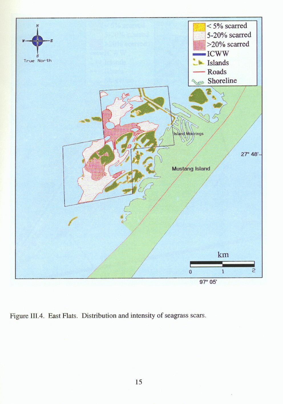
IV. DISCUSSION The majority of moderate and severe scarring of seagrasses in Corpus Christi Bay National Estuarine program areas occurred in areas kno
|
|
|
- Earl Collins
- 5 years ago
- Views:
Transcription
1

2
3
4
5
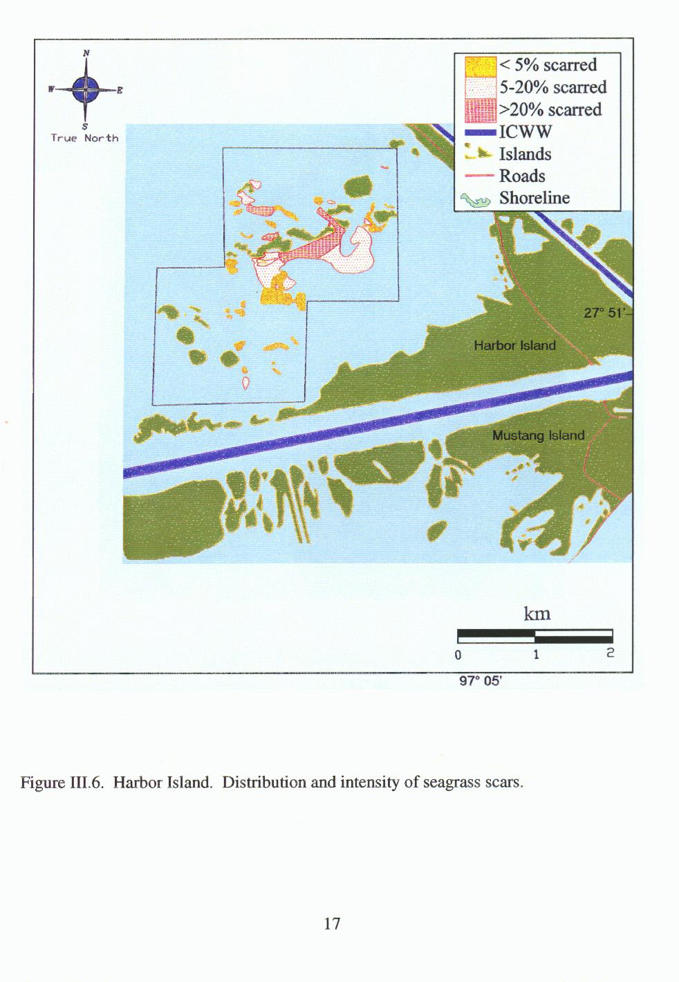
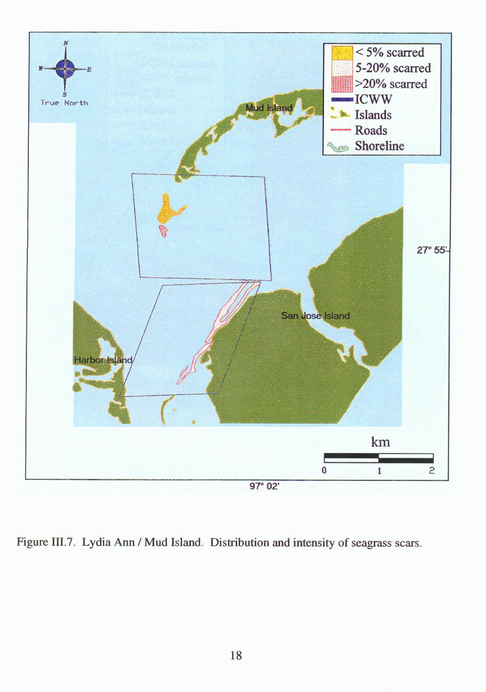
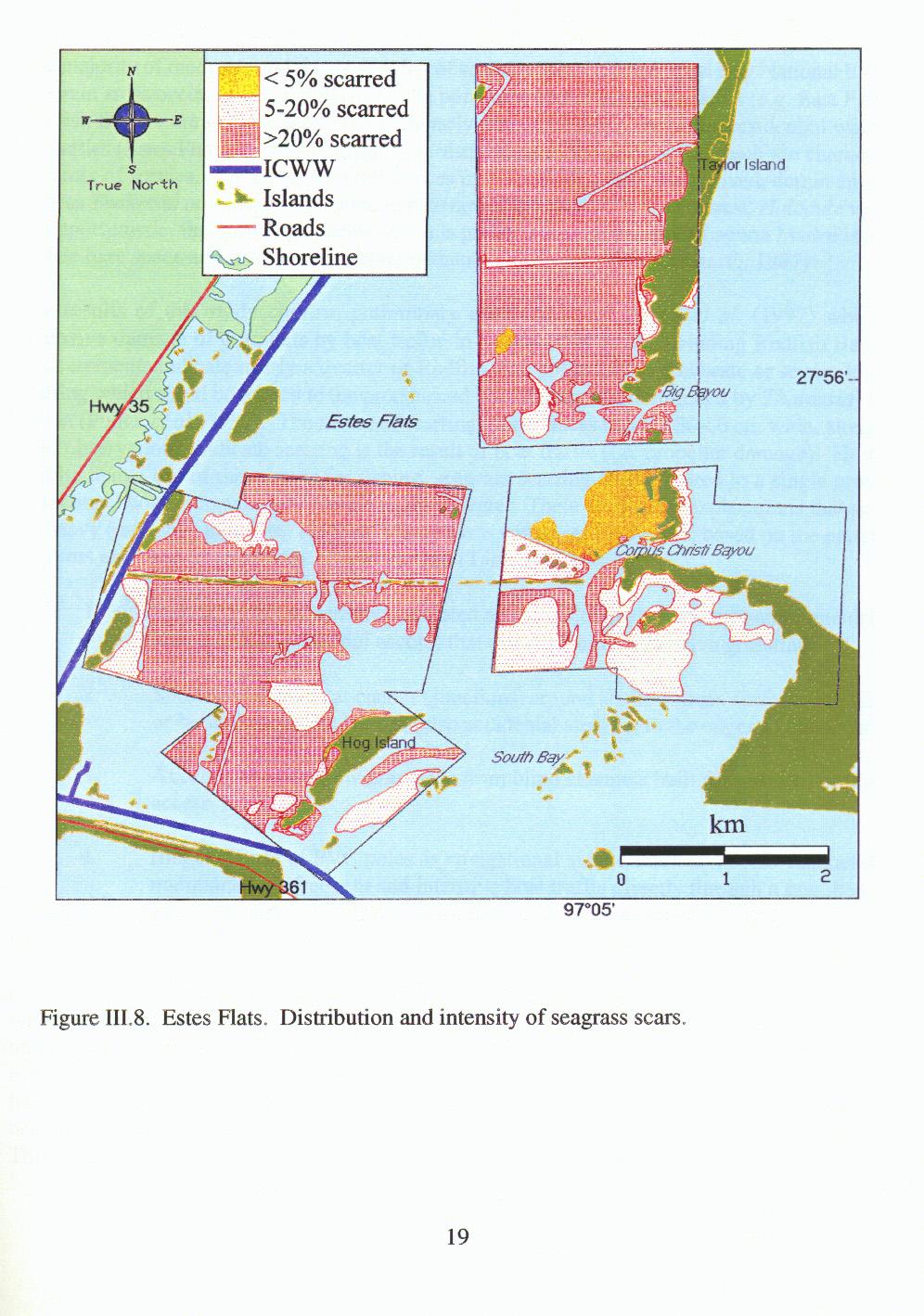
6 IV. DISCUSSION The majority of moderate and severe scarring of seagrasses in Corpus Christi Bay National Estuarine program areas occurred in areas known to be popular with recreational boaters (e.g. East Flats and Redfish Bay) or are in close proximity to densely populated areas, including residential waterfront properties (Estes Flats). Heavy scarring in northern areas of the study area, which are characterized by a mix of species, may also reflect differences in seagrass recovery. Long-lived, dominant species such as Thalassia testudinum do not recolonize new substrate rapidly; in contrast, Halodule wrightii, an opportunistic, fast-growing species which is predominant in the upper Laguna Madre is able to invade bare space and recover more quickly than many species (Fonseca et al., 1987). The results of this study confirm preliminary observations of Pulich et al. (1997) who noted extensive damage of grassflats by boat traffic in a number of areas, including Redfish Bay. Our measurements indicate nearly a quarter of Redfish Bay suffers from moderate or severe levels of scarring which could be related to the pronounced loss of seagrass (dominated by Thalassia) in this region (Pulich et al., 1997). The nature of scarring, linear traces that are cm wide, along with field observations, indicate scarring is the result of boat traffic (i.e. propeller damage). However, despite heavy use of these areas for fishing, seagrass scarring is not limited to a single group; all recreational boaters may be responsible to some degree. There are several explanations that account for heavy (moderate to severe) scarring in seagrasses within our study area, based on the patterns of the scars and field observations. These include (Table IV.1). 1. Proximity (P) to densely populated areas (including waterfront homes and dredged channels for residential access) that directly border extensive grassflats. 2. Shortcuts (S) taken at channel junctions, around shallow areas surrounding islands, or between adjacent islands (also accidental straying to the edges of channels). 3. Access (A) to shallow grassbeds from blind channels built for gas well or pipeline access. 4. Illegal (I) use of PVC poles as navigational aids to mark an access channel that is maintained via frequent and intensive boat traffic directly through a grassbed. Our observations agree with conclusions reached by Sargent et al. (1995) who suggested that scarring of seagrasses in Florida was related to accidental events (misjudgement of water depth, or channel location), shortcuts to access an area or maintain a channel through a grassbed, or ignorance with respect to damage caused by propellers and importance of seagrass habitats. Consequently, management priorities should focus on education, but should also include efforts by state resource managers to improve marking of secondary channels to minimize damage to adjacent grassbeds. In heavily populated regions, it may be appropriate to construct channels to minimize random and destructive boating through grassbeds, thereby concentrating boat traffic in designated channels. This would also discourage construction of illegal channels through grassbeds. In addition, areas 20
7 Table IV.1. Most probable explanations for scarring observed within the various regions surveyed in this study (regions are listed in order of decreasing scarring severity). See text for full explanation of abbreviations. Region Probable Cause 1 Comments Estes Flats S,P,I Adjacent to waterfront homes, high population density, channels not well marked, heavy use area East Flats S Popular hunting and fishing area, near waterfront homes and canals Shamrock Island A,S Channels not marked Redfish Bay A,S Channels surround large, shallow grassbed JFK Causeway A,S,P,I Many gas well channels, PVC poles mark channel through grassbed Lydia Ann/Mud Island S South tip of Mud Island is very shallow compared to surrounding areas Upper Laguna Madre A,S,I Adjacent to waterfront homes and canals, high population density, poles mark channels through grassbeds Harbor Island A,S Gas well channels provide access to grassbeds 1 Probable Cause: P=proximity, S=shortcut, A=access point, I=illegal use of navigational aids showing seagrass decline that are heavily impacted by scarring from boat traffic may need to be given additional protection through a combination of efforts, including signage to educate the public and increased enforcement. In addition to providing the first quantitative data on scarring of seagrasses on the south Texas coast, this study provides valuable baseline information for assessment of recovery. Although no work has been conducted in Texas on seagrass recovery from scarring, studies from Florida indicate the process is slow and may take up to 10 years, depending on species and location (reviewed by Sargent et al., 1995). Also, recent work on water flow during tidal exchanges in submerged aquatic plant communities indicates channelization within vegetative stands has distinct effects on water flow and exchange (Rybicki et al., 1997); if true for seagrasses, then scarring of grassbeds could lead to long-term changes in community structure. Consequently, future research efforts should be directed toward understanding of the long-term effects of seagrass scarring, especially to justify the variety of management options that are available to state resource agencies. 21
8 V. REFERENCES Dunton, K.H Production ecology of Ruppia maritima L. s. 1. and Halodule wrightii Aschers in two subtropical estuaries. J. Exp. Mar. Biol. Ecol. 143: Dunton, K.H Seasonal growth and biomass of the subtropical seagrass Halodule wrightii in relation to continuous measurements of underwater irradiance. Mar. Biol. 120: Durako, M.J., M.O. Hall, F. Sargent, and S. Peck Propeller scars in seagrass beds: and assessment and experimental study of recoloniztion in Weedon Island State Preserve, Florida. in: Proceedings from the 19 th Annual Conference of Wetlands Restoration and Creation. Webb, F. (ed.). Hillsborough Community College. Tampa, Florida. p Eleuterius, L.N Seagrass ecology along the coasts of Alabama, Louisiana, and Mississippi. in: Proceedings of the Symposium on Subtropical-tropical Seagrasses of the Southeastern United States. Durako, M.J., R.C. Phillips, and R.R. Lewis III (eds.). St Petersburg: Florida Mar. Res. Pub. No. 42, p Falkner, E Aerial Mapping: Methods and Applications. CRC Press, Boca Raton, Florida. 311 p. Fesenmaier, D.R., S. Um, W.S. Roehl, A.S. Mills, T. Ozuna, Jr., L.L. Jones, and R. Guarjardo Regional and statewide economic impacts of sportsfishing, other recreational activities and commercial fishing associated with bays and estuaries of the Texas Gulf Coast. TAES, Texas A&M Universtiy, College Station, Texas, 55 p. Fonseca, M.S., W.J. Kenworthy, and G.W. Thayer Transplanting of the seagrasses Halodule wrightii, Syringodium filiforme, and Thalassia testudinum for habitat development in the southeast region of the United States. Tech. Rept. EL US Army Engineer Waterways Experiment Station, Vicksburg, MS. Lipton, D.W., K.F. Wellman, I.C. Shiefer, and R.F. Weiher Economic valuation of natural resources a handbook for coastal resource policymakers. NOAA Coastal Ocean Program Decision Analysis Series No. 5. Moulton, D.W., T.E. Dahl, and D.M. Dall Texas Coastal Wetlands; Status and Trends, mid- 1950s to early 1990s. U.S. Department of the Interior, Fish and Wildlife Service, Albuquerque, New Mexico. 32 p. National Oceanic and Atmospheric Administration (NOAA) Fisheries of the United States, Current fisheries statistics no National Marine Fisheries Service. Silver Spring, MD: U.S. Government Printing Office. 111 p. 22
9 Phillips, R.C Observations of the ecology and distribution of Florida seagrasses. Prof. Pap. Ser. Fla. St. Bd. Conserv. 2:1-72. Pulich, W., Jr., C. Blair, and White, W.A Current status and historical trends of seagrasses in the Corpus Christi Bay National Estuary Program study area. Final Project Report, Corpus Christi Bay National Estuary Program, Corpus Christi, Texas. Rybicki, N.B., H.L. Jenter, V. Carter, R.A. Baltzer, and M. Turtora Observations of tidal flux between a submersed aquatic plant stand and the adjacent channel in the Potomac river near Washington, D.C. Limnology and Oceanography 42(2): Sargent, F.J., T.J. Leary, D.W. Crewz, and C.R. Kruer Scarring of Florida s seagrasses: assessment and management options. FMRI Tech. Rep. TR-1. Florida Mar. Res. Inst., St. Petersburg, Florida. 37 p. + app. Zieman, J.C The ecological effects of physical damage from motor boats on turtle grass beds in southern Florida. Aquat. Bot. 2:
Seagrasses: Vital Habitat in Texas Estuaries
 Seagrasses: Vital Habitat in Texas Estuaries Cindy Hobson Water Resources Branch Coastal Fisheries Division Texas Parks and Wildlife Department February 17, 2015 Why Care About Seagrass? Sustain coastal
Seagrass surveys must be conducted between the dates of April 1 st and October 31 st with the following exceptions:
 Florida Fish and Wildlife Conservation Commission (FWC) Recommended Survey Protocols for Estuarine and Marine Submerged Aquatic Vegetation (SAV) related to Permitting Applications 12/14/2011 DRAFT 1) Survey
Florida Seagrass Integrated Mapping and Monitoring Program
 Florida Seagrass Integrated Mapping and Monitoring Program - 2004 The following document is composed of excerpts taken from the 2011 publication, Seagrass Integrated Mapping and Monitoring for the State
Summary Report for Sarasota Bay
 Summary Report for Sarasota Bay Contacts: Jay Leverone, Sarasota Bay Estuary Program Jon Perry and Rene Janneman, Sarasota County Greg Blanchard, Manatee County Kristen Kaufman, Southwest Florida Water
Use of Conservation Moorings as a Component of Eelgrass Restoration in two Massachusetts Harbors
 Use of Conservation Moorings as a Component of Eelgrass Restoration in two Massachusetts Harbors Massachusetts Bays Program Division of Marine Fisheries Jay Baker, Tay Evans, Mass Bays Program MarineFisheries
Seagrasses Along the Texas Coast:
 Seagrasses Along the Texas Coast: Using GIS to Examine Differences from 2011-2012 Sara Wilson 12/07/2012 Department of Marine Science University of Texas at Austin CE 394K GIS in Water Resources Wilson
Design and Construction of Docks to Minimize Seagrass Impacts
 Design and Construction of Docks to Minimize Seagrass Impacts PURPOSE: This technical note provides recommendations for the design and construction of dock and terminal platform structures to minimize
Eelgrass Survey PARADISE CAY BELVEDERE, MARIN COUNTY CALIFORNIA. Prepared For:
 Eelgrass Survey PARADISE CAY BELVEDERE, MARIN COUNTY CALIFORNIA Prepared For: Radford (Skid) Hall, Ph.D. Land Planning and Permitting Consultant 500 Airport Blvd., Suite 350 Burlingame, CA 94010 (650)
SOCIETAL GOALS TO DETERMINE ECOSYSTEM HEALTH: A FISHERIES CASE STUDY IN GALVESTON BAY SYSTEM, TEXAS
 SOCIETAL GOALS TO DETERMINE ECOSYSTEM HEALTH: A FISHERIES CASE STUDY IN GALVESTON BAY SYSTEM, TEXAS Anthony S. Pait, NOAA, National Centers for Coastal Ocean Science Thomas P. O Connor, David R. Whitall,
The Blue Heron Slough Conservation Bank
 1 The Blue Heron Slough Conservation Bank CONSERVATION BANKING July 19-23, 2010 CASE STUDY SERIES The Blue Heron Slough Conservation Bank (Washington) I. OVERVIEW & BACKGROUND: Location: Snohomish River
Advancing the Gulf of Mexico Shellfish Initiative (GoMexSI)
") Advancing the Gulf of Mexico Shellfish Initiative (GoMexSI) Gulf States Marine Fisheries Commission Mississippi-Alabama Sea Grant Consortium Gulf States Marine Fisheries Commission Annual Meeting March
Advancing the Gulf of Mexico Shellfish Initiative (GoMexSI) Gulf States Marine Fisheries Commission Mississippi-Alabama Sea Grant Consortium Gulf States Marine Fisheries Commission Annual Meeting March
W. JUDSON KENWORTHY. ADJUNCT FACULTY APPOINTMENT: Nov present; Department of Biological Sciences, University of North Carolina Wilmington, N.
 W. JUDSON KENWORTHY Center for Coastal Fisheries and Habitat Research, NCCOS, NOS, NOAA, 101 Pivers Island Road, Beaufort, NC 28516 (252) 728-8750 Fax: (252)728-8784 jud.kenworthy@noaa.gov BORN: May 22,
Status and Trends Report: 2012 Penaeid Shrimp Species Account FL FWCC FWRI SEDAR-PW6-RD July 2014
 Status and Trends Report: 2012 Penaeid Shrimp Species Account FL FWCC FWRI SEDAR-PW6-RD52 11 July 2014 Status and Trends Report: 2012 Penaeid Shrimps Species Account Florida Fish and Wildlife Conservation
CHAPTER 11.1 THE WORLD OCEAN MARINE BIOMES NOTES
 CHAPTER 11.1 THE WORLD OCEAN MARINE BIOMES NOTES 1. The world ocean can be divided into zones both and. The,, and zones that apply to large lakes also apply to the ocean. 2. In addition to the depth zones,
National Oceanic and Atmospheric Administration (NOAA)/ Mulberry Phosphate Trustee Council September 12, 2013
/ Mulberry Phosphate Trustee Council September 12, 2013") OYSTER REEF CREATION PROJECT DESIGN AND IMPLEMENTATION IN HILLSBOROUGH BAY, FLORIDA TAMPA BAY REGIONAL PLANNING COUNCIL AGENCY ON BAY MANAGEMENT MEETING National Oceanic and Atmospheric Administration
OYSTER REEF CREATION PROJECT DESIGN AND IMPLEMENTATION IN HILLSBOROUGH BAY, FLORIDA TAMPA BAY REGIONAL PLANNING COUNCIL AGENCY ON BAY MANAGEMENT MEETING National Oceanic and Atmospheric Administration
Boat Scarring Effects on Submerged Aquatic Vegetation in Virginia (Year 1)
") Boat Scarring Effects on Submerged Aquatic Vegetation in Virginia (Year 1) Final Report to the Virginia Saltwater Recreational Fishing Development Fund Virginia Marine Resources Commission Newport News,
Boat Scarring Effects on Submerged Aquatic Vegetation in Virginia (Year 1) Final Report to the Virginia Saltwater Recreational Fishing Development Fund Virginia Marine Resources Commission Newport News,
Habitat selection during settlement of three Caribbean coral reef fishes: Indications for directed settlement to seagrass beds and mangroves
 Notes 903 Limnol. Oceanogr., 52(2), 2007, 903 907 E 2007, by the American Society of Limnology and Oceanography, Inc. Habitat selection during settlement of three Caribbean coral reef fishes: Indications
Seagrass Status and Stresses Status Trend Assessment, Causes. Seagrass cover Declining Losses, storm runoff
 Florida Seagrass Integrated Mapping and Monitoring Program Summary Report for Choctawhatchee Bay Contacts: Alison McDowell, Choctawhatchee Bay Alliance, Northwest Florida State College, and Paul Carlson,
Geospatial Video Monitoring of Benthic Habitats Using the Shallow-Water Positioning System (SWaPS)
") Geospatial Video Monitoring of enthic Habitats Using the Shallow-Water Positioning System (SWaPS) Diego Lirman University of Miami Rosenstiel School of Marine and tmospheric Science 4600 Rickenbacker Cswy.
Geospatial Video Monitoring of enthic Habitats Using the Shallow-Water Positioning System (SWaPS) Diego Lirman University of Miami Rosenstiel School of Marine and tmospheric Science 4600 Rickenbacker Cswy.
Time Will Tell: Long-term Observations of the Response of Rocky-Habitat Fishes to Marine Reserves in Puget Sound
 Time Will Tell: Long-term Observations of the Response of Rocky-Habitat Fishes to Marine Reserves in Puget Sound Wayne A. Palsson, Robert E. Pacunski, and Tony R. Parra Washington Department of Fish and
Comparative growth of pinfish in field mesocosms across marsh, oyster, and soft-bottom habitat types in a Mississippi estuary
 Comparative growth of pinfish in field mesocosms across marsh, oyster, and soft-bottom habitat types in a Mississippi estuary Virginia Shervette and Fran Gelwick Department of Wildlife and Fisheries Sciences
FLORIDA MARINE RESEARCH INSTITUTE TECHNICAL REPORTS. Scarring of Florida s Seagrasses: Assessment and Management Options
 FLORIDA MARINE RESEARCH INSTITUTE TECHNICAL REPORTS Scarring of Florida s Seagrasses: Assessment and Management Options F.J. Sargent, T.J. Leary, D.W. Crewz and C.R. Kruer Florida Department of Environmental
Longshore Bar Creation: a viable option for seagrass restoration?
 Longshore Bar Creation: a viable option for seagrass restoration? Lindsay M. Cross, Tampa Bay Estuary Program Holly Greening, Tampa Bay Estuary Program Michael Seifert, Tampa Port Authority Susan Burtnett,
Figure 1. Schematic illustration of the major environments on Mustang Island.
 STOP #1: PACKERY CHANNEL BEACH TO BAY We will start this field guide near the north jetty of Packery Channel and hike across the island to Corpus Christi Bay (fig. 1). The island emerges from the Gulf
May 12, Dear Superintendent Kimball:
 May 12, 2013 Superintendent Dan Kimball Everglades National Park National Park Service, U.S. Department of the Interior 40001 State Road 9336 Homestead, FL 33034-6733 Dear Superintendent Kimball: The National
Indian River Lagoon: Lessons, Challenges and Opportunities
 Indian River Lagoon: Lessons, Challenges and Opportunities Upper Chain of Lakes Lake Kissimmee Kissimmee River Indian River Lagoon Caloosahatchee Estuary Lake Okeechobee St. Lucie Estuary Mark Perry, Executive
Significant Ecological Marine Area Assessment Sheet
 Significant Ecological arine Area Assessment Sheet Name: ouhora arbour arine Values Summary: The entrance subtidal channel, tidal flats, seagrass mangrove and saltmarsh habitats of ouhora arbour have given
Oregon Estuaries defined: (Goal 16)
") Bob Bailey, Manager, Oregon Coastal Management Program Oregon Estuaries defined: (Goal 16) includes estuarine water, tidelands, tidal marshes, and submerged lands. Estuaries extend upstream to the head
Bob Bailey, Manager, Oregon Coastal Management Program Oregon Estuaries defined: (Goal 16) includes estuarine water, tidelands, tidal marshes, and submerged lands. Estuaries extend upstream to the head
Managing Chesapeake Bay s Land Use, Fish Habitat, and Fisheries: Studies. Jim Uphoff & Margaret McGinty, Fisheries Service
 Managing Chesapeake Bay s Land Use, Fish Habitat, and Fisheries: Positive Image and or Negative Graphic Case Studies Jim Uphoff & Margaret McGinty, Fisheries Service Maryland Fisheries Service has been
FACT SHEET MCGREGOR LAKE RESTORATION HABITAT PROJECT POOL 10, UPPER MISSISSIPPI RIVER, WISCONSIN ENVIRONMENTAL MANAGEMENT PROGRAM
 FACT SHEET MCGREGOR LAKE RESTORATION HABITAT PROJECT POOL 10, UPPER MISSISSIPPI RIVER, WISCONSIN ENVIRONMENTAL MANAGEMENT PROGRAM LOCATION McGregor Lake is located within a mid-river island in Pool 10
Case Study 3. Case Study 3: Cebu Island, Philippines MPA Network 10
 Case studies of mpa networks Case Study 3: Cebu Island, Philippines MPA Network 10 Location and background Cebu Island in the Philippines lies in the center of the Visayan Islands, known as an area high
Essential Fish Habitat: An overview of the consultation requirement for the American Association of Port Authorities
 Essential Fish Habitat: An overview of the consultation requirement for the American Association of Port Authorities National Marine Fisheries Service, Southeast Regional Office Habitat Conservation Division,
Project Webpage:
 Project Webpage: http://nature.ly/marinesatlanticbightera Coastal Data and Full Metadata: http://easterndivision.s3.amazonaws.com/marine/sab MA/SABMACoastalEcosystems.zip Coastal Chapter: http://easterndivision.s3.amazonaws.com/marine/sab
FLORIDA BAY: AN ECOSYSTEM ON THE BRINK
 E V E R G L A D E S R E S T O R A T I O N F A C T S H E E T FLORIDA BAY: AN ECOSYSTEM ON THE BRINK Background T he Florida Bay estuary is located at the southern edge of the Everglades ecosystem at the
SKIATOOK LAKE MANAGEMENT PLAN
 SKIATOOK LAKE MANAGEMENT PLAN Background Skiatook Lake impounds Hominy Creek, 5 miles west of Skiatook in Osage County, Oklahoma (Figure 1). Skiatook Lake covers 10,540 surface acres and was constructed
Biological Review of the 2014 Texas Closure
 Biological Review of the 2014 Texas Closure Report to the Gulf of Mexico Fishery Management Council by James M. Nance, Ph.D. Southeast Fisheries Science Center Galveston Laboratory January 2015 Introduction
Definitions. The environment is the biological, chemical, physical, and social conditions that surround organisms.
 Marine Ecosystems Definitions An ecosystem is a geographically specified system of organisms (including humans), the environment, and the processes that control its dynamics. The environment is the biological,
Good Mooring to You! Jensen Beach Mooring Field. Kathy Fitzpatrick, P.E. Coastal Engineer, Martin County
 Good Mooring to You! Kathy Fitzpatrick, P.E. Coastal Engineer, Martin County Penny Cutt Regional Manager, Coastal Systems International Mooring Field Advantages Provide a safe and secure anchorage at a
New York District Briefing Template
 New York District Briefing Template New York District US Army Corps of Engineers Insert Text Here Dredging Windows Workshop November 30, 2011 Aquatic Biological Survey Winter Flounder Jenine Gallo & Kate
located Let s go fishing Hydrilla
 Our Lake of the Month for November is Lake August (set your GPS to 27.2750-81.4136). The elevation of Lake August is 102.5. Lake August is a 52 acre dredge hole lake (man-made from a former wetland; see
EVALUATING THE EFFECTS OF BIVALVE SHELLFISH AQUACULTURE AND ITS ECOLOGICAL ROLE IN THE ESTUARINE ENVIRONMENT IN THE UNITED STATES
 EVALUATING THE EFFECTS OF BIVALVE SHELLFISH AQUACULTURE AND ITS ECOLOGICAL ROLE IN THE ESTUARINE ENVIRONMENT IN THE UNITED STATES Brett Dumbauld USDA Agricultural Research Service, Hatfield Marine Science
Coastal and marine recreation in New England is ingrained in the region s economic and
 RECREATION Coastal and marine recreation in New England is ingrained in the region s economic and social fabric. Recreation on the ocean and coast includes many of New Englanders most time-honored and
LK Increasing knowledge on sea grass habitats and dugong distribution at selected sites in North Western Sri Lanka Project progress July2016
 LK6-2132 Increasing knowledge on sea grass habitats and dugong distribution at selected sites in North Western Sri Lanka Project progress July2016 ORCA Ocean Resources Conservation Association This is
Warm-up # 7 A day 5/17 - B day 5/18 UPDATE YOUR TABLE OF CONTENTS
 Warm-up # 7 A day 5/17 - B day 5/18 UPDATE YOUR TABLE OF CONTENTS Question: List all examples of surface water on Earth. Answer: Rivers and streams, lakes and reservoirs, (ponds) wetlands, estuaries and
Eelgrass and Macroalgae Presence/Absence Preliminary Surveys BHP Proposed Grays Harbor Potash Export Facility A Task 400
 Memorandum 40600-HS-MEM-55036 Revision 0 Date: 26 July 2018 Subject: Eelgrass and Macroalgae Presence/Absence Preliminary Surveys BHP Proposed Grays Harbor Potash Export Facility A17.0202.00 Task 400 INTRODUCTION
USING BIOLOGICALLY IMPORTANT PHYSICAL CHARACTERISTICS OF ESTUARIES TO CLASSIFY AUSTRALIAN AND NEW ZEALAND ESTUARIES
 USING BIOLOGICALLY IMPORTANT PHYSICAL CHARACTERISTICS OF ESTUARIES TO CLASSIFY AUSTRALIAN AND NEW ZEALAND ESTUARIES Michael Whelan, Southern Cross University, Australia. Peter Saenger, Southern Cross University,
An Overview of Methods for Estimating Absolute Abundance of Red Snapper in the Gulf of Mexico
 An Overview of Methods for Estimating Absolute Abundance of Red Snapper in the Gulf of Mexico JM Drymon 1, Greg Stunz 2 1. Mississippi State University, Coastal Research and Extension Center 2. Harte Research
Statewide Summary for Mississippi
 Statewide Summary for Mississippi By Cynthia A. Moncreiff 1 Background Although the coastline of Mississippi spans only 113 linear kilometers (70 mi), the estuaries within its borders constitute a much
Protect Our Reefs Grant Interim Report (October 1, 2008 March 31, 2009) Principal investigators: Donald C. Behringer and Mark J.
 Principal investigators: Donald C. Behringer and Mark J.") Investigating the role of the spotted spiny lobster (Panulirus guttatus) in the recovery of the long spined sea urchin (Diadema antillarum) on the coral reefs of the Florida Keys Protect Our Reefs Grant
Investigating the role of the spotted spiny lobster (Panulirus guttatus) in the recovery of the long spined sea urchin (Diadema antillarum) on the coral reefs of the Florida Keys Protect Our Reefs Grant
Assessment of Creosote-Treated Structures and Other Artificial Substrates in San Francisco Bay
 Assessment of Creosote-Treated Structures and Other Artificial Substrates in San Francisco Bay Jennifer Hunt, Christine Werme, Kristen Cayce, Marcus Klatt, William Winner, Erin Beller, Eric Polson, Robin
Cat Island Chain Restoration
 Cat Island Chain Restoration 1820s Fox River Military Road Map to Fort Howard 1845 Chart of Green Bay & Fox River Cat Island Chain - 1938 Cat Island Brown County Aerial Photography, 1938 Historic Western
Seagrasses of the Virgin Islands
 Seagrasses of the Virgin Islands Seagrasses are flowering plants that live underwater. These marine plants resemble the land species of grasses in that they have long blade-like leaves. Seagrasses grow
Restoration of Intertidal Oyster Reefs Affected by Boating Activity in Mosquito Lagoon, Florida
 Restoration of Intertidal Oyster Reefs Affected by Boating Activity in Mosquito Lagoon, Florida Andrea Barber, University of Central Florida Dr. Linda Walters, University of Central Florida Anne Birch,
SEDAR 10 DW- 08. REVIEW OF TAGGING DATA FOR GAG GROUPER (Mycteroperca microlepis) FROM THE SOUTHEASTERN GULF OF MEXICO REGION
 FROM THE SOUTHEASTERN GULF OF MEXICO REGION") SEDAR 1 DW- 8 REVIEW OF TAGGING DATA FOR GAG GROUPER (Mycteroperca microlepis) FROM THE SOUTHEASTERN GULF OF MEXICO REGION 1985-25. THIS DOCUMENT SHOULD NOT BE CITED WITHOUT AUTHOR S PERMISSION. Mauricio
SEDAR 1 DW- 8 REVIEW OF TAGGING DATA FOR GAG GROUPER (Mycteroperca microlepis) FROM THE SOUTHEASTERN GULF OF MEXICO REGION 1985-25. THIS DOCUMENT SHOULD NOT BE CITED WITHOUT AUTHOR S PERMISSION. Mauricio
Concept for a Whale Protection Zone for the Endangered Southern Resident Killer Whale
 Concept for a Whale Protection Zone for the Endangered Southern Resident Killer Whale Supported (in part) by the Charlotte Martin Foundation and the Norcliffe Foundation The concept described in this document
COMMUNITY WATERSHED PROJECT
 SABINE RED RIVER COMMUNITY WATERSHED PROJECT A Watershed Approach to Aquatic Resources Do you have a stake in the water, the wildlife, the use of the land? Help us do for fish what was done for ducks*.
Habitat Fact Sheets. Rocky habitats are dominated by seaweeds and often mussels, which rely on the rocks for attachment.
 Habitat Fact Sheets Habitats in the Gulf of Maine serve many important roles for the environment and for humans as well. These include: cycling nutrients, filtering pollution, trapping sediments, storing
Orange County MPA Watch A n n u a l R e p o r t
 Orange County MPA Watch 2 0 1 4 A n n u a l R e p o r t WHAT IS AN MPA? Marine Protected Areas (MPAs) are discrete geographic marine or estuarine areas designed to protect or conserve marine life and habitat.
U.S. Fish and Wildlife Service Native American Crosscut Funding
 U.S. Fish and Wildlife Service Native American Crosscut Funding Tribal / Interior Budget Council National Budget Meeting L Enfant Plaza Hotel Washington, DC November 8, 2013 U.S. Fish and Wildlife Service
Age and growth of the young swordfish Xiphias gladius L. in Taiwan waters using otolith. Chi-Lu Sun, Hsiao-Ling Lin, an Su-Zan Yeh
 SCTB15 Working Paper BBRG-8 Age and growth of the young swordfish Xiphias gladius L. in Taiwan waters using otolith Chi-Lu Sun, Hsiao-Ling Lin, an Su-Zan Yeh Institute of Oceanography National Taiwan University
Conservation and Restoration Florida s Coastal Marshes: An Overview of MESS. Jeff Beal, Kent Smith, Erin McDevitt, Maria Merrill
 Conservation and Restoration Florida s Coastal Marshes: An Overview of MESS Jeff Beal, Kent Smith, Erin McDevitt, Maria Merrill FWC s MESS: -Marine/Estuarine Subsection -within Aquatic Habitat Conservation
Orange County MPA Watch M o n i t o r i n g H u m a n U s a g e
 Orange County MPA Watch M o n i t o r i n g H u m a n U s a g e WHAT IS AN MPA? Marine Protected Areas (MPAs) are discrete geographic marine or estuarine areas designed to protect or conserve marine life
US Dept. of Commerce NOAA National Marine Fisheries Service Office of Law Enforcement
 US Dept. of Commerce NOAA National Marine Fisheries Service Office of Law Enforcement Galveston, TX Field Office SA Charles Tyer SA Richard Cook SA Matt Clark ASAC Mark Kinsey NOAA Office of Law Enforcement
MEMORANDUM. Existing Operations. City of Clearwater. Michael Herrman. Date: January 26, Seminole Boat Launch Overview. M&N Job No.
 1509 W. Swann Avenue, Suite 225 Tampa, FL 33606 (813) 258-8818 Fax (813) 258-8525 www.moffattnichol.com MEMORANDUM To: From: City of Clearwater Michael Herrman Date: Subject: Seminole Boat Launch Overview
Appendix Template for Submission of Scientific Information To Describe Ecologically or Biologically Significant Marine Areas
 Appendix Template for Submission of Scientific Information To Describe Ecologically or Biologically Significant Marine Areas Abstract (in less than 150 words) Coastal and marine areas: Africa Somalia has
Follets Island Nearshore Beach Nourishment Project
 Coast & Harbor Engineering A division of Hatch Mott MacDonald Follets Island Nearshore Beach Nourishment Project Arpit Agarwal, P.E. April 1, 2016 Project Site!"#$% &'(% &)*+% )#,'-+% Shoreline Erosion
Managing Development and Chesapeake Bay s Estuarine Fish
 Managing Development and Chesapeake Bay s Estuarine Fish Habitat Image and or Graphic Fisheries James H. Uphoff Jr. and Margaret M. McGinty Maryland Fisheries Service Funded through USFWS Federal Aid Maryland
Integrated Pest Management Program Final Report
 Integrated Pest Management Program Final Report Shoreline Stewardship Program: Be a Lake Pan Pal Joan Bradshaw Specialized Regional Programs for Natural Resource Citrus, Hernando, Pasco and Sumter Counties
Agenda Item Summary BACKGROUND. Attachment 1
 Agenda Item Summary Attachment 1 BACKGROUND Oregon s recreational abalone fishery was suspended by emergency rule beginning January 1, 2018. This suspension was due to 1) low densities of red abalone,
VIDEO TRANSCRIPT. A Proposal to Expand the Flower Garden Banks National Marine Sanctuary An interview with Sanctuary Superintendent, G.P.
 VIDEO TRANSCRIPT A Proposal to Expand the Flower Garden Banks National Marine Sanctuary An interview with Sanctuary Superintendent, G.P. Schmahl (Opening scene of Flower Garden Banks National Marine Sanctuary
EVALUATION OF BEACH EROSION UP-DRIFT OF TIDAL INLETS IN SOUTHWEST AND CENTRAL FLORIDA, USA. Mohamed A. Dabees 1 and Brett D.
 EVALUATION OF BEACH EROSION UP-DRIFT OF TIDAL INLETS IN SOUTHWEST AND CENTRAL FLORIDA, USA Mohamed A. Dabees 1 and Brett D. Moore 1 The paper discusses the analysis of up-drift beach erosion near selected
dugon) ) and Seagrass in Thailand: Present Status and Future Challenges Kanjana Adulyanukosol Sombat Poovachiranon Mickmin Charuchida
 ) and Seagrass in Thailand: Present Status and Future Challenges Kanjana Adulyanukosol Sombat Poovachiranon Mickmin Charuchida") Dugong ( (Dugong dugon) ) and Seagrass in Thailand: Present Status and Future Challenges Kanjana Adulyanukosol Sombat Poovachiranon Mickmin Charuchida Phuket Marine Biological Center (PMBC) Department
Dugong ( (Dugong dugon) ) and Seagrass in Thailand: Present Status and Future Challenges Kanjana Adulyanukosol Sombat Poovachiranon Mickmin Charuchida Phuket Marine Biological Center (PMBC) Department
Office of Science & Technology
 NOAA Fisheries Highlights of FEUS 2015 Highlights from the Annual Report Fisheries Economics of the United States, 2015 Office of Science & Technology Fisheries and the Economy U.S. fisheries provide jobs,
Public Notice U.S. Army Corps In Reply to Application Number CENAB-OP-RMS (NATIONAL HARBOR (FORMERLY PORT Baltimore District AMERICA])
![Public Notice U.S. Army Corps In Reply to Application Number CENAB-OP-RMS (NATIONAL HARBOR (FORMERLY PORT Baltimore District AMERICA])](/thumbs/89/100795623.jpg "Public Notice U.S. Army Corps In Reply to Application Number CENAB-OP-RMS (NATIONAL HARBOR (FORMERLY PORT Baltimore District AMERICA])") Public Notice U.S. Army Corps In Reply to Application Number of Engineers CENAB-OP-RMS (NATIONAL HARBOR (FORMERLY PORT Baltimore District AMERICA]) 88-01361 PN 14-05 Comment Period: January 16, 2014 to
Public Notice U.S. Army Corps In Reply to Application Number of Engineers CENAB-OP-RMS (NATIONAL HARBOR (FORMERLY PORT Baltimore District AMERICA]) 88-01361 PN 14-05 Comment Period: January 16, 2014 to
Nicholas Brown. 31 Bennett Rd Wolfeboro NH Application submitted
 Nicholas Brown 31 Bennett Rd Wolfeboro NH 03894 603-856-5454 Nick4634@gmail.com Application submitted 8-12-2017 Description of proposed project A. General Methodology The site located approximately 600
5/8/2018. Estuaries are classified by: > Mode of formation e.g. glaciers, deposition, sea level rise. > Patterns of water circulation
 Prepared by Diana Wheat-LBCC Compare and contrast the various types of estuaries, including their origin, size, shape, and general location on earth. Distinguish and describe the different types of habitats
Manatee Protection and Boating Safety Comprehensive Management Plan
 Manatee Protection and Boating Safety Comprehensive Management Plan Indian River County Environmental Planning Section T A B L E O F C O N T E N T S EXISTING CONDITIONS... Page 1 INTRODUCTION... Page 1
Proposed Terrestrial Critical Habitat for the Northwest Atlantic Loggerhead Sea Turtle Population. U.S. Fish and Wildlife Service
 Proposed Terrestrial Critical Habitat for the Northwest Atlantic Loggerhead Sea Turtle Population U.S. Fish and Wildlife Service History of Loggerhead Listing (joint responsibility USFWS and NOAA Fisheries)
Using Population Models to Evaluate Management Alternatives for Gulf-strain Striped Bass
 Using Population Models to Evaluate Management Alternatives for Gulf-strain Striped Bass Alex Aspinwall Alabama Cooperative Fisheries and Wildlife Research Unit Elise Irwin U.S Geological Survey Introduction
Water depth (MTL) at the deep edge of seagrass meadows in Tampa Bay measured by GPS carrierphase processing: Evaluation of the technique
 at the deep edge of seagrass meadows in Tampa Bay measured by GPS carrierphase processing: Evaluation of the technique") University of South Florida Scholar Commons Reports Tampa Bay Area Study Group Project 1-1-2000 Water depth (MTL) at the deep edge of seagrass meadows in Tampa Bay measured by GPS carrierphase processing:
University of South Florida Scholar Commons Reports Tampa Bay Area Study Group Project 1-1-2000 Water depth (MTL) at the deep edge of seagrass meadows in Tampa Bay measured by GPS carrierphase processing:
2001 REVIEW OF THE ATLANTIC STATES MARINE FISHERIES COMMISSION FISHERY MANAGEMENT PLAN FOR WEAKFISH (Cynoscion regalis)
") 2001 REVIEW OF THE ATLANTIC STATES MARINE FISHERIES COMMISSION FISHERY MANAGEMENT PLAN FOR WEAKFISH (Cynoscion regalis) Plan Review Team Rick Cole, DE Louis Daniel, NC Charles Lesser, DE Rob O Reilly,
2001 REVIEW OF THE ATLANTIC STATES MARINE FISHERIES COMMISSION FISHERY MANAGEMENT PLAN FOR WEAKFISH (Cynoscion regalis) Plan Review Team Rick Cole, DE Louis Daniel, NC Charles Lesser, DE Rob O Reilly,
Evaluation of the Use of Grid Platforms to Minimize Shading Impacts to Seagrasses
 Wetlands Regulatory Assistance Program ERDC TN-WRAP-01-02 Evaluation of the Use of Grid Platforms to Minimize Shading Impacts to Seagrasses INTRODUCTION Background. Seagrasses are widely recognized as
Rookery Bay National Estuarine Research Reserve. Team OCEAN at Rookery Bay
 Rookery Bay National Estuarine Research Reserve Team OCEAN at Rookery Bay What is Team OCEAN? Why have it at Rookery Bay? How is it implemented? Partnership + + National Estuarine Research Reserves Partnership
2015 Maryland FMP Report (June 2016) Section 10. Maryland Coastal Bays Blue Crab (Callinectes sapidus)
 Section 10. Maryland Coastal Bays Blue Crab (Callinectes sapidus)") 2015 Maryland FMP Report (June 2016) Section 10. Maryland Coastal Bays Blue Crab (Callinectes sapidus) Maryland s Coastal Bays and Chesapeake blue crab fisheries are managed separately under two different
2015 Maryland FMP Report (June 2016) Section 10. Maryland Coastal Bays Blue Crab (Callinectes sapidus) Maryland s Coastal Bays and Chesapeake blue crab fisheries are managed separately under two different
RESEARCH AND PROFESSIONAL EXPERIENCE
 Kelly M. Darnell The University of Southern Mississippi Gulf Coast Research Laboratory 703 East Beach Drive, Ocean Springs, MS 39564 Office: 228-872-4278; Cell: 270-991-7259; Email: kelly.darnell@usm.edu
Gulf of the Farallones National Marine Sanctuary Safe Harbor for Sea Turtles
 Gulf of the Farallones National Marine Sanctuary Safe Harbor for Sea Turtles Photos by Doug Perrine They re here now! Leatherbacks swim 6,000 miles from Indonesia to California to Feed on Jellyfish ~ August
NYS Coastal Waters. Water Resources of NYS: THE NATURE of the COASTAL ZONE. NYS Coastal Waters. NYS Coastal Atlas. Coastal Zone Management 10/10/2014
 Water Resources of NYS: THE NATURE of the COASTAL ZONE NYS Coastal Waters NYS is the only state to border the Atlantic Ocean and the Great Lakes (Lakes Erie and Ontario). Great Lakes shoreline: 577 miles
Orange County MPA Watch A n n u a l R e p o r t
 Orange County MPA Watch 2 0 1 5 A n n u a l R e p o r t WHAT IS AN MPA? Marine Protected Areas (MPAs) are discrete geographic marine or estuarine areas designed to protect or conserve marine life and habitat.
OYSTER RESTORATION IN EUROPE & USA: REALISING MULTIPLE BENEFITS. Morven Robertson
 OYSTER RESTORATION IN EUROPE & USA: REALISING MULTIPLE BENEFITS Morven Robertson OYSTERS ECOSYSTEM SERVICES Oysters provide a suite of ecosystem services Biodiversity hotspots Water quality Denitrification
FINAL ENVIRONMENTAL IMPACT STATEMENT ON BROWARD COUNTY SHORE PROTECTION PROJECT SEGMENTS II AND III BROWARD COUNTY, FLORIDA
 FINAL ENVIRONMENTAL IMPACT STATEMENT ON BROWARD COUNTY SHORE PROTECTION PROJECT SEGMENTS II AND III BROWARD COUNTY, FLORIDA 1. PROJECT PURPOSE AND NEED 1.1. PROJECT AUTHORITY. 1.1.1. INITIAL AUTHORIZATION.
National Report on Large Whale Entanglements
 National Report on Large Whale Entanglements Confirmed in the United States in 2017 In 2017, 76 confirmed cases of large whale entanglements were documented along the coasts of the United States. Seventy
RESEARCH Massachusetts Recreational Boater Survey. Project Summary
 Coastal and Marine Spatial Planning RESEARCH Project Summary 2010 Massachusetts Recreational Boater Survey The 2010 Massachusetts Recreational Boater Survey gathered spatial and economic data relating
Domain (island) wide estimates of mutton snapper (Lutjanus analis) abundance for three US Caribbean Islands based on habitat-derived densities
 wide estimates of mutton snapper (Lutjanus analis) abundance for three US Caribbean Islands based on habitat-derived densities") Domain (island) wide estimates of mutton snapper (Lutjanus analis) abundance for three US Caribbean Islands based on habitat-derived densities SEDAR REPORT # SEDAR14-AW2 Prepared May 2007 by Christopher
Domain (island) wide estimates of mutton snapper (Lutjanus analis) abundance for three US Caribbean Islands based on habitat-derived densities SEDAR REPORT # SEDAR14-AW2 Prepared May 2007 by Christopher
2012 Maryland FMP Report (July 2013) Section 15. Red Drum (Sciaenops ocellatus)
 Section 15. Red Drum (Sciaenops ocellatus)") 1981 1983 1985 1987 1989 1991 1995 1997 1999 2001 2003 2005 2007 2009 2011 Pounds 2012 Maryland FMP Report (July 2013) Section 15. Red Drum (Sciaenops ocellatus) Chesapeake Bay FMP In 2012, red drum were
1981 1983 1985 1987 1989 1991 1995 1997 1999 2001 2003 2005 2007 2009 2011 Pounds 2012 Maryland FMP Report (July 2013) Section 15. Red Drum (Sciaenops ocellatus) Chesapeake Bay FMP In 2012, red drum were
021 Deer Management Unit
 021 Deer Management Unit Geographic Location: Deer Management Unit (DMU) 021 is 1,464 square miles in size and is located in the central Upper Peninsula (UP). This DMU is dominated by publicly owned land
SMOOTH HAMMERHEAD SHARK (HHS)
") SMOOTH HAMMERHEAD SHARK (HHS) (Sphyrna zygaena) HHS1 1. FISHERY SUMMARY Smooth hammerhead sharks (Sphyrna zygaena) are not currently managed under the QMS. No assigned fishing allowances exist. However,
SMOOTH HAMMERHEAD SHARK (HHS) (Sphyrna zygaena) HHS1 1. FISHERY SUMMARY Smooth hammerhead sharks (Sphyrna zygaena) are not currently managed under the QMS. No assigned fishing allowances exist. However,
Marine Ecosystems. Aquatic Ecosystems Section 2
 Marine Ecosystems Marine ecosystems are located mainly in coastal areas and in the open ocean. Organisms that live in coastal areas adapt to changes in water level and salinity. Organisms that live in
SARASOTA BAY ESTUARY PROGRAM OYSTER HABITAT MONITORING RESULTS: YEAR 1. Jay R. Leverone
 SARASOTA BAY ESTUARY PROGRAM OYSTER HABITAT MONITORING RESULTS: YEAR 1 by Jay R. Leverone Mote Marine Laboratory 1600 Ken Thompson Parkway Sarasota, Fl 34236 to Gary Raulerson Sarasota Bay Estuary Program
AGENCY/ORGANIZATION OFFICE/DIVISION SECTION/SUBSECTION ACTIONS (Related to Coral Reefs) Natural Resources Planning and Management Division
 Natural Resources Planning and Management Division") AGENCY/ORGANIZATION OFFICE/DIVISION SECTION/SUBSECTION ACTIONS (Related to Coral Reefs) Broward County Environmental Protection and Growth Department Natural Resources Planning and Division Broward County
AGENCY/ORGANIZATION OFFICE/DIVISION SECTION/SUBSECTION ACTIONS (Related to Coral Reefs) Broward County Environmental Protection and Growth Department Natural Resources Planning and Division Broward County
Seagrass Surveys in Kampot
 Coastal Annual Forum 23 rd October 2014 Sihanoukville, Cambodia Seagrass Surveys in Kampot Presentation by Louis Bourne INTERNATIONAL UNION FOR CONSERVATION OF NATURE Presentation Overview Location and