Clowhom Project Water Use Plan
|
|
|
- Coral Andra Harmon
- 5 years ago
- Views:
Transcription
1 Clowhom Project Water Use Plan Fish Productivity Monitoring Implementation Year 4 Reference: COMMON-2 Fish Productivity Monitoring Year 4 Data Summary 2010 Study Period: September 16 to October 6, 2010 D.J. Bates FSCI Biological Consultants Sechelt, BC and D. Paul Resource Management shíshálh Nation Sechelt, BC April 30, 2011
2 Executive Summary The Clowhom Lake Fish productivity monitoring study was developed and initiated in 2006 to assess and track changes in fish productivity. Recently, it has been speculated that fish productivity had decreased following the impoundment of Clowhom Lake in This decrease may be a result of loss in productive littoral habitat, but little data exists to support this hypothesis. As a result a 20-year monitoring plan designed to track change in fish productivity through sampling of rearing populations was developed and implemented in 2006 with sampling to occur every 2 years throughout the 20-year study. In the fall of 2010, the third sampling period was completed. The upper and lower basins were again netted using both sinking and floating nets and a drift net. The shoreline was also trapped using baited minnow traps. All captured fish were identified, enumerated, measured and scales collected for aging. Data was recorded and filed for comparison to future years. Results of the 2010 sampling revealed 3 salmonid species and 2 non-salmonids utilizing the lake. The salmonid samples included Rainbow and Cutthroat trout and Kokanee salmon. The rainbow sample included 5 age classes (1+, 2+, 3+, 4+ and 5+) and the cutthroat trout sample yielded 2 age classes (3+ and 4+). Two age classes (1+ and 2+) of Kokanee salmon were also caught. In addition to the salmonids, sticklebacks and prickly sculpin were caught along the shoreline using minnow traps. The total catch in 2010 was 29 salmonids. In addition to the sampling of fish a swim survey of the lower reach of the Clowhom River was completed on October 6, This swim focused on documenting use of habitats by salmonids. There was only one salmonid observed during the swim and its identity was not confirmed. The 2010 sampling data provides the third year of this multi year project and the year for the compilation of the first 5-year summary report. As data continues to be collected it will be reviewed against preceding years and the summary analysis reports. All comparisons will be within the context of measureable changes in population status and health. 2
3 Table of Contents Page Table of Contents... 3 List of Tables Study Area Methods Fish Collection Fish Biometrics Scale Analysis Fish Data Analysis Lower Clowhom River Salmonid Population Survey Results/Discussion Fish Capture Fish Biometrics Scale Analysis Stomach Analysis Lower Clowhom River Salmonid Population Survey Conclusion References Appendix
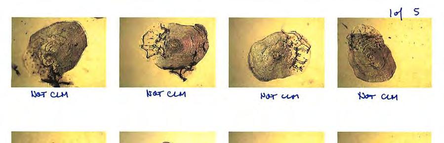
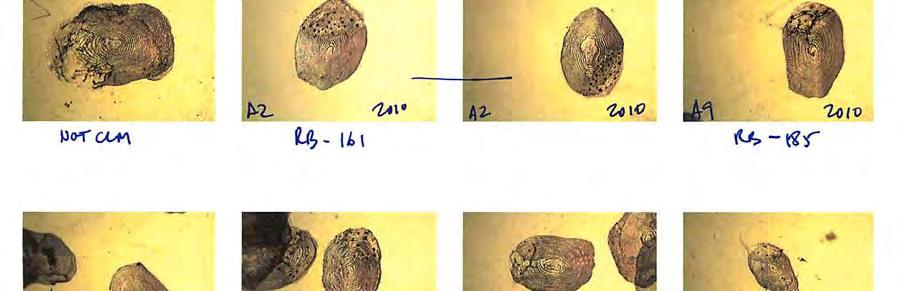
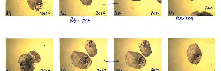
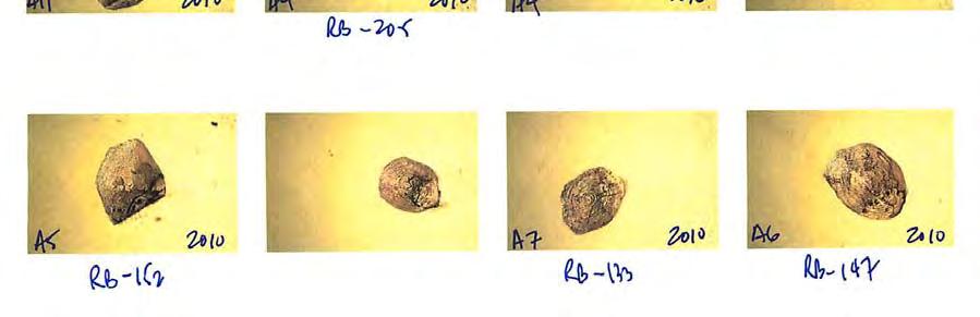
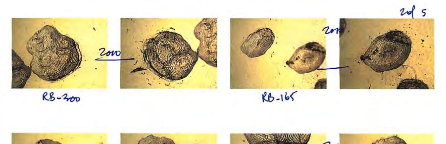
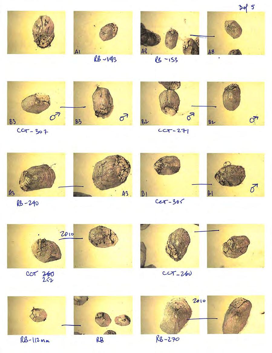
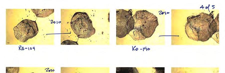
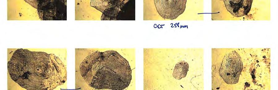
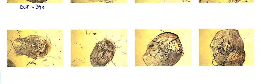
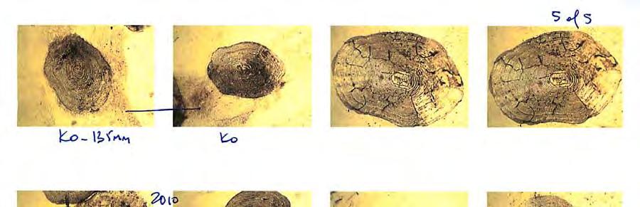
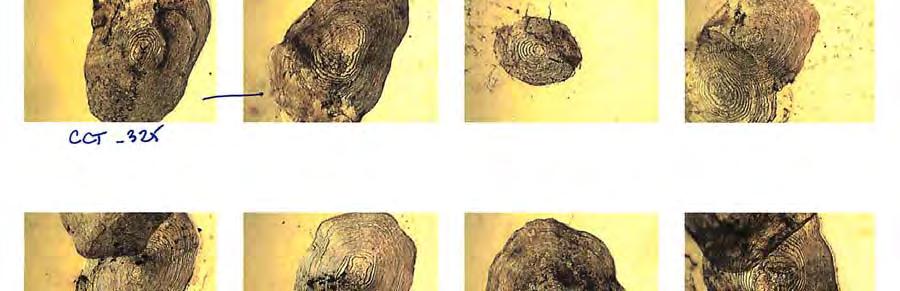
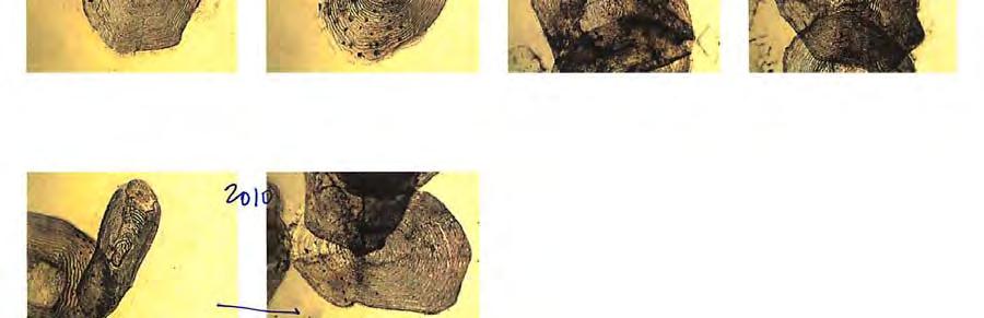
4 List of Figures Page Figure 1: Location of Clowhom Lake (red circle) in relation to Sechelt (red dot), BC Figure 2: Sample locations selected for the gill net and minnow trapping of fish within Clowhom Lake. Each location is identified along the shoreline with flagging tape (Bates, 2006)... 8 Figure 3: Length versus weight relationships for salmonids captured in Clowhom Lake reservoir between September 16 and 17, Figure 4: Gill net catch per unit effort (CPUE) in each year of Clowhom Lake sampling List of Tables Table I: Type and set times for the sampling gear used to collect fish samples in the Clowhom Lake Reservoir Table II: Species captured in Clowhom Lake sampling, September 16 and 17, Table III: Summary of catch by gear type and sample location in Clowhom Lake between September 16 and 17, Table IV: Summary of length-at-age data for the salmonids caught in Clowhom Lake between September 16 and 17, Table V: Summary of wet weight data for the salmonids caught in Clowhom Lake between September 16 and 17, List of Appendices Appendix I: Digital images of the scales collected from select salmonids caught in gill nets during the 2010 sample season. The age information is used to designate captured fish to suitable age classes
5 1.0 Introduction In 2006, the Sechelt First Nation and BC Hydro began the first year of a 20-year monitoring program documenting fish productivity in the Clowhom Lake reservoir. The monitoring program was implemented following recommendations made during the water use planning (WUP) process. In an earlier study by Bruce (2004) a decrease in reservoir productivity was reported following the impoundment and creation of Clowhom Lake in As a result of the earlier results, BC Hydro developed the fish productivitymonitoring program, addressing concerns and bottlenecks to production. The monitoring program addresses specific management questions that include: Does fish productivity change through time following the WUP implementation? Is any observed change correlated with changes in effective littoral zone changes? Is the population of salmonids in Clowhom lake recruitment limited and what role does the river play? If no change is observed what is the reason for the decline initially? Do operation based solutions exist for the reservoir that would benefit fish productivity? The purpose of this report is to present data collected in the third sample year that was completed in the fall of Study Area The Clowhom Lake reservoir, measuring approximately 745-ha, is located at the head of Salmon Inlet northeast of Sechelt BC. The study area for this project includes the entire lake and 9 pre-selected sampling sites. The selected sites correspond to locations reported by Bruce (2004) and Bates (2006, 2008) representing both the upper and lower portion of the reservoir. Figure 1 shows the location of Clowhom Lake in relation to Sechelt BC. 3.0 Methods 3.1 Fish Collection A two-person crew completed the fish sampling process between September 16 and 17, Fish collection was made using gill nets and baited Gee minnow traps. Gill net configuration was consistent with mesh sizes recommended for BC lake inventories (RIC, 1998) and Bruce (2004). As in past years, a total of three net strategies were employed; floating, sinking and drift sets. The floating and sinking sets were anchored near shore and oriented perpendicular to the shoreline. The drift net set was released perpendicular to the lake and mid-line, then allowed to move with the wind and lake currents(s). Gill net sample periods were ranged between 2 to 4-hours depending on ease of retrieval. 5
 in relation to Sechelt (red dot),")
6 Figure 1: Location of Clowhom Lake (red circle) in relation to Sechelt (red dot), BC. 6
7 All captured salmonids retained for detailed biometric data collection. In addition to the gill net sets, baited Gee minnow traps were used to sample habitat near the lake shoreline. These traps were fished in groups of 5, baited with salmon roe that was housed in perforated containers, preventing consumption by the captured fish. All traps were set at mid-day and allowed to fish for approximately 24-hours. The locations of sample sites were approximately the same as sites sampled in 2006 and 2008 using UTM coordinates determined with a Garmin GPSMap 60CSx handheld receiver. Sample locations are illustrated in Figure 2. Table I provides the spatial reference points and the gear and soak times for each location. Table I: Type and set times for the sampling gear used to collect fish samples in the Clowhom Lake Reservoir. Date Site UTM Gear Set Time Duration ID Northing Easting Type Deployed Retrieved (hr.) Sept 16 A Float GN Day 9:18 13:10 3:56 B Sink GN Day 9:40 13:26 3:46 Sept 17 C MT Night 10:00 9:55 23:55 D MT Night 10:21 10:17 23:56 Sept 17 E Float GN Day 11:08 13:00 1:52 F Sink GN Day 10:22 14:12 3:50 Sept 17 G MT Night 10:47 10:15 23:28 H MT Night 11:08 12:02 24:56 Sept 17 I - - Drift GN Day 11:25 13:55 2:30 Note: GN = gillnet and MT minnow traps (5) 3.2 Fish Biometrics All captured were enumerated and recorded by collection method. Captured salmonids were identified to species, and the fork length to the nearest millimeter (mm) and wet weight nearest 0.1 gms were measured (Bates, 2008; 2006). Scale samples were collected from representative size ranges of each species following standard scale collection methodology and placed on glass microscope slides. The scales were then compressed with another slide, labeled and stored for future reading. Live fish (those in the Gee traps), were also identified and enumerated then released unharmed. All dead fish collected in gill nets were retained and returned to the lab. Dead fish (gill net captures) were dissected and the sex identified based on presence of gonads. The stomachs of each fish was also removed and opened for examination and the contents reported. 7


8 Figure 2: Sample locations selected for the gill net and minnow trapping of fish within Clowhom Lake. Each location is identified along the shoreline with flagging tape (Bates, 2006). 8
9 3.3 Scale Analysis Scales from all salmonids captured were returned to the lab for reading. Each scale was reviewed under a compound dissecting microscope and a smear selected for clarity. The representative scale(s) is then photographed using a digital camera mounted on the dissecting microscope and the image stored as a JPEG file. The image was read on a desktop computer. The digital images of the scales are attached in Appendix I. The scale analysis was completed in a similar iterative fashion reported by Bruce (2004) and Bates (2006 and 2008). The age is reported using the convention n+ values where the + denotes a partial year. 3.4 Fish Data Analysis All captured fish were reported by catch type and will be used to compare catch-per-unit effort in the first 5-year summary report. Biometric data is summarized by captured species with the age class and the condition coefficient (CC) for each species calculated using: Condition Coefficient (CC) = wet weight (gms) x length (cm) -3 x Lower Clowhom River Salmonid Population Survey Clowhom Lake supports salmonids that require accessible stream habitat to spawn. The Clowhom River enters the lake at the north end and is characterized by a low gradient reach. On October 6, 2010, a swim survey was conducted using two crewmembers swimming parallel lanes through the length of Clowhom River from the 17-km bridge to the wetland, an approximate 750-m length. The 2-man team swam side by side within their designated lane. The purpose was to note any salmonids holding in the length of stream from downstream of the bridge to the lake. Ideally the team would detect any Kokanee that may have moved into the lake. All observed salmonids were noted along with the time spent during the swim. If possible the species would also be reported. 4.0 Results/Discussion 4.1 Fish Capture A total of 119 fish were caught during the sampling period. The total catch was comprised of 3 species of salmonids (24.4%) and 2 non-salmonid species (75.6%) (Table II) with the gill nets accounting for 23.5% of the total catch and the minnow traps the balance. All non-salmonid species were caught along the shoreline in minnow traps. 9
10 Table II: Species captured in Clowhom Lake sampling, September 16 and 17, Salmonids Non-salmonids Common Name Scientific Name Common Name Scientific Name Cutthroat Trout (CCT) Oncorhynchus clarki Prickly sculpin (CAS) Cottus asper Rainbow Trout (RB) O. mykiss Three-spine stickleback (TSB) Gasterosteus spp. Kokanee (KO) O. nerka The total catch was also separated by capture method and the catch reported by sample location (Table III). All dead fish caught in the gill nets were retained for dissection. Table III: Summary of catch by gear type and sample location in Clowhom Lake between September 16 and 17, Site Gear Type Species Number A Floating GN Rainbow Trout 11 B Sinking GN Cutthroat Trout 3 C MT Prickly Sculpin 13 C MT Stickleback 14 D MT Prickly Sculpin 3 D MT Stickleback 24 E Floating GN Rainbow Trout 9 E Floating GN Kokanee 3 F Sinking GN Cutthroat Trout 2 G MT Rainbow Trout 1 G MT Stickleback 8 H MT Prickly Sculpin 2 H MT Stickleback 26 I Drift GN Kokanee Fish Biometrics Nose to fork length and wet weight data were compiled and applied to the appropriate age classes determined from age classes determined in 2006 and The largest species caught was the cutthroat trout in the sinking gill nets. Table IV, V and VI summarize the length-at-age, weight and condition coefficient data for the three species of salmonids captured in Figure 3 shows the weight versus length relationship for each salmonid species caught with previous years length and weight data also included. The total sample size in 2010 was 29. This compared to a capture of 23 in 2008 and 19 in Generally an increase in capture that may be a reflection of the increased soak times used in It should also be noted that in 2010 the reservoir was drawn down for emergency repairs. This may have resulted in easier capture of salmonids if the fish were congregated at higher densities at the sample sites. In Figure 4 the catch per unit effort is shown for each of the years; 2006, 2008 and These CPUE are broken into the net locations where 1=A, 2=B, 3=E, 4=F and 5=I. 10
11 In total only 11 fish were retained for dissection. These fish were examined for gonadal development and sexed accordingly. The stomachs from each was then removed and dissected further. Food items in the stomachs, if present, were identified to broad categories and recorded for future reference. Table IV: Summary of length-at-age data for the salmonids caught in Clowhom Lake between September 16 and 17, Species specific fork length (mm) Rainbow Trout Cutthroat Trout Kokanee Age n Mean(SD) n Mean(SD) n Mean(SD) (4.04) (17.68) (10.83) (7.07) (13.98) (9.54) (17.32) (1.41) Table V: Summary of wet weight data for the salmonids caught in Clowhom Lake between September 16 and 17, Species specific wet weight (gms) Rainbow Trout Cutthroat Trout Kokanee Age n Mean(SD) n Mean(SD) n Mean(SD) (0.50) (14.85) (7.80) (14.78) (14.02) (6.59) (19.55) (32.53) Table VI: Summary of condition coefficients for the salmonids caught in Clowhom Lake between September 16 and 17, Species specific condition coefficient Rainbow Trout Cutthroat Trout Kokanee Age n Mean(SD) n Mean(SD) N Mean(SD) (0.11) (0.04) (0.05) (0.06) (0.05) (0.08) (0.10) (0.11)


12 Figure 3: Length versus weight relationships for salmonids captured in Clowhom Lake reservoir between September 16 and 17,
13 Figure 4: Gill net catch per unit effort (CPUE) in each year of Clowhom Lake sampling. 4.3 Scale Analysis Scales collected from salmonids caught in the gill nets were photographed and archived as digital images. These are included in Appendix I and will be reviewed with scale images from previous years (2006 and 2008). While the age structure is not expected to change, the small sample sizes, combined from each sample year allow the development of a more reliable age class structure by species. 4.4 Stomach Analysis In 2010 the stomachs from each dead salmonid caught in the gill nets was removed and examined. The larger cutthroat trout all had Three spine Stickleback in their stomachs. The Kokanee examined did not have any identifiable foodstuffs while the smaller trout, including the rainbow appeared to be feeding on terrestrial life stages including ants and dipterans. 4.3 Lower Clowhom River Salmonid Population Survey On October 6, 2010 a two-person crew swam a 700-m length of Clowhom River below the 17-km bridge toward the wetland located at the northeast end of the lake. The swim 13
14 was divided into 3 sections and each diver drifted through a lane repeating the drift 3 times. There was only one salmonid observed during this effort. As previously reported this length of stream provides little suitable rearing habitat but good spawning near the bridge. It was concluded that the area does not provide significant rearing opportunities and is likely avoided because of the lack of suitable cover. 5.0 Conclusion The completion of the third season of salmonid sampling marks the end of the first 5-year rotation defined under the terms of Reference for this project. As a result the data collected in 2006, 2008 and 2010 will be summarized and presented in a summary document. The delivery for this data analysis report is July 15, References Resource Inventory Committee (1998) Reconnaissance Fish and habitat inventory: Standards and procedures. BC Ministry of Fisheries, Victoria, BC. Bates, D.J Clowhom Lake Water Use Plan. Fish Productivity Monitoring Year 2. Shíshálh Nation and FSCI Biological Consultant. Bates, D.J Clowhom Lake Water Use Plan. Fish Productivity Monitoring Year 1. Shíshálh Nation and FSCI Biological Consultant. Bruce, James, Results of fish studies Clowhom Lake Water Use Plan. BC Hydro Technical Note Com-FTC-TN-001. Burnaby, BC. Johnston, N.T. and Slaney, P.A Fish habitat assessment procedures. Watershed Restoration Technical Circular No. 8. B.C. Ministry of Environment, Lands and Parks and Ministry of Forests, Victoria, B.C. 14
15 Appendix Appendix I: Digital images of the scales collected from select salmonids caught in gill nets during the 2010 sample season. The age information is used to designate captured fish to suitable age classes. 15
16 16

17 17
18 18

19 19
20 20
Clowhom Project Water Use Plan. Fish Productivity Monitoring. Reference: COMMON-2. Fish Productivity Monitoring Year 2 Data Summary 2008
 Clowhom Project Water Use Plan Fish Productivity Monitoring Reference: COMMON-2 Fish Productivity Monitoring Year 2 Data Summary 2008 Study Period: August 25 to October 16, 2008 D.J. Bates Resource Management
Clowhom Project Water Use Plan
 Clowhom Project Water Use Plan Fish Productivity Monitoring Implementation Year 5 Reference: COMMON-2 Fish Productivity Monitoring Year 5 Data Summary 2011 Study Period: September 2011 D.J. Bates FSCI
Assessment of Elizabeth Lake as a Potential Candidate for Stocking
 Assessment of Elizabeth Lake as a Potential Candidate for Stocking Region 1, Nanaimo West Coast Planning Unit Ministry of Water, Land and Air Protection Prepared by: Laura Cassin Scott Silvestri 2002 1.0
Executive Summary Mount Milligan 2004
 Executive Mount Milligan 2004 Mt. Milligan Lake is a shallow and productive, 24 ha, marl bottomed lake situated 110 km southwest of Mackenzie. A stocking assessment was conducted at Mt. Milligan Lake between
SITE C FISHERIES STUDIES 2011 REVELSTOKE RESERVOIR FISH INVENTORY DATA REPORT
 Project number: 4534 Version: 2 January 13, 2012 SITE C FISHERIES STUDIES 2011 REVELSTOKE RESERVOIR FISH INVENTORY DATA REPORT Prepared for: Bruce Mattock, R.P. Bio. Fisheries and Aquatic Lead Site C Clean
Executive Summary Gantahaz Lake 2006
 Executive Summary Gantahaz Lake 2006 A stocking assessment was conducted at Gantahaz Lake on September 29, 2006. This was the third assessment completed since the inception of stocking in 1976. The management
Executive Summary Lavoie Lake 2000
 Executive Lavoie Lake 2000 A stocking assessment was conducted at Lavoie Lake in 2000 to determine the status of the fishery. Lavoie Lake is a relatively shallow and productive wild rainbow trout lake,
Executive Summary Opatcho Lake 2004
 Executive Summary Opatcho Lake 2004 Stocking assessments were conducted at Opatcho Lake on two separate occasions: May 20, 2004, and September 27, 2004. Opatcho Lake is a 40.5 ha lake situated 48 km southeast
2011 Haha Lake Northern Pike Control
 2011 Haha Lake Northern Pike Control Prepared By: Christin Davis Ministry of Forests, Lands, and Natural Resource Operations #401-333 Victoria Street Nelson, BC V1L 4K3 Summary In 2005, northern pike (Esox
Fish Passage Culvert Assessment for Cahilty Creek Watershed FIA Project #
 Fish Passage Culvert Assessment for Cahilty Creek Watershed FIA Project # 4602004 Prepared for Weyerhaeuser Company Ltd. Jason Ladyman R.P.F. 1550 Mission Flats Road PO Box 40 Kamloops BC V2C 5K3 Prepared
NEVADA DEPARTMENT OF WILDLIFE STATEWIDE FISHERIES MANAGEMENT
 NEVADA DEPARTMENT OF WILDLIFE STATEWIDE FISHERIES MANAGEMENT FEDERAL AID JOB PROGRESS REPORTS F-20-52 2016 Lake Tahoe Rainbow Trout Study WESTERN REGION NEVADA DEPARTMENT OF WILDLIFE, FISHERIES DIVISION
Firth Creek Habitat Enhancement Project 1993
 Firth Creek Habitat Enhancement Project 1993 A. R. Langston December 1993 PWFWCP Report No. 77 The Peace/Williston Fish & Wildlife Compensation Program is a cooperative venture of BC Hydro and the provincial
WHALE TAIL EXPANSION PROJECT 2018 FISH AND FISH HABITAT FIELD INVESTIGATIONS: AGNICO EAGLE MINES LTD. - MEADOWBANK DIVISION
 WHALE TAIL EXPANSION PROJECT 2018 FISH AND FISH HABITAT FIELD INVESTIGATIONS: AGNICO EAGLE MINES LTD. - MEADOWBANK DIVISION Submitted to: Agnico Eagle Mines Ltd: Meadowbank Division Regional Office - 93,
Rivers and Streams Investigations
 Rivers and Streams Investigations Brian J. Flatter, Regional Fisheries Biologist Lance Hebdon, Regional Fisheries Biologist Jeff Dillon, Regional Fishery Manager ABSTRACT Three sections of the lower Boise
Campbell River Project Water Use Plan
 Campbell River Project Water Use Plan Upper and Lower Campbell Lake Fish Spawning Success Assessment Implementation Year 1 Reference: JHTMON-3 JHTMON-3: Upper and Lower Campbell Lake Fish Spawning Success
P/FR/SK/54 DE LEEUW, A. D. MAMIN RIVER STEELMEAD: A STUDY ON A LIMITED TAGGING CPOX c. 1 mm SMITHERS MAMIN RIVER STEELHEAD: A STUDY ON A LIMITED
 P/FR/SK/54 DE LEEUW, A. D. MAMIN RIVER STEELMEAD: A STUDY ON A LIMITED TAGGING CPOX c. 1 mm SMITHERS MAMIN RIVER STEELHEAD: A STUDY ON A LIMITED TAGGING STUDY UNDERTAKEN DURING WINTER, 1984 by A.D. de
Figure 7-2. Fish sampling locations in Lake 1. August 25, 2018.
 Figure 7-2. Fish sampling locations in Lake 1. August 25, 2018. 24 Figure 7-3. Fish sampling locations in Lake 5. August 26, 2018. 25 Figure 7-4. Fish sampling locations in Lake 8. August 2-3, 2018. 26
Quemahoning Reservoir
 Pennsylvania Fish & Boat Commission Biologist Report Quemahoning Reservoir Somerset County May 2011 Trap Net, Gill Net and Electrofishing Survey Quemahoning Reservoir is an 899 acre impoundment located
Peace River Water Use Plan. Monitoring Program Terms of Reference. GMSMON-1 Peace River Creel Survey
 Peace River Water Use Plan Monitoring Program Terms of Reference GMSMON-1 Peace River Creel Survey April 10, 2008 Terms of Reference for the Peace River Water Use Plan Monitoring Program: Peace River Creel
Executive Summary Chubb Lake 2004
 Executive Chubb Lake 2004 A stocking assessment was conducted at Chubb Lake on September 29, 2004. The objective of this assessment was to document the status of the fishery. Chubb Lake is a 67.3 ha lake
NEVADA DIVISION OF WILDLIFE STATEWIDE FISHERIES MANAGEMENT FEDERAL AID JOB PROGRESS REPORTS F YELLOWSTONE CUTTHROAT TROUT EASTERN REGION
 NEVADA DIVISION OF WILDLIFE STATEWIDE FISHERIES MANAGEMENT FEDERAL AID JOB PROGRESS REPORTS F-20-48 2012 YELLOWSTONE CUTTHROAT TROUT EASTERN REGION NEVADA DEPARTMENT OF WILDLIFE, FISHERIES DIVISION ANNUAL
Ecology and control of invasive Northern Pike in the Columbia River, Canada
 Ecology and control of invasive Northern Pike in the Columbia River, Canada Brian Heise, Daniel Doutaz, Matthias Herborg, Matt Neufeld, David Derosa, Jeremy Baxter 19 th International Conference on Aquatic
LONE TREE POCKET ESTUARY RESTORATION 2004 FISH SAMPLING AND PRE-RESTORATION PROJECT MONITORING REPORT
 Skagit River System Cooperative 11426 Moorage Way P.O. Box 368 LaConner, WA 98257-368 Phone: 36-466-7228 Fax: 36-466-447 www.skagitcoop.org LONE TREE POCKET ESTUARY RESTORATION 24 FISH SAMPLING AND PRE-RESTORATION
Yale Reservoir Kokanee (Oncorhynchus nerka) Escapement Report 2016
 Escapement Report 2016") Yale Reservoir Kokanee (Oncorhynchus nerka) Escapement Report 2016 North Fork Lewis River Hydroelectric Project Yale FERC No. 2071 Prepared by: Jeremiah Doyle, PacifiCorp April 4, 2017 1.0 INTRODUCTION
Yale Reservoir Kokanee (Oncorhynchus nerka) Escapement Report 2016 North Fork Lewis River Hydroelectric Project Yale FERC No. 2071 Prepared by: Jeremiah Doyle, PacifiCorp April 4, 2017 1.0 INTRODUCTION
Freshwater Fish Assessment
 Alaska Department of Transportation & Public Facilities Seward Highway MP 7-9 6-7 Freshwater Fish Assessment March 14, 8 Prepared by HDR Alaska C Street, Suite 3 Anchorage, Alaska 993 Project Number: BR-BH-NH-OA3
Executive Summary Crystal Lake 2004
 Executive Summary Crystal Lake 2004 A stocking assessment was conducted on Crystal Lake during the fall of 2004. Both a sinking and a floating gillnet (90 m, standard mesh) were set on September 14, 2004.
1998 Willow Creek Downstream Migrant Trap Report. Draft. Prepared By: C. A. Walker. Lower Trinity Ranger District. Six Rivers National Forest
 1998 Willow Creek Downstream Migrant Trap Report Draft Prepared By: C. A. Walker Lower Trinity Ranger District Six Rivers National Forest September 1998 Executive Summary The downstream migrant trap was
MINISTRY OF ENVIRONMENT ENVIRONMENTAL STEWARDSHIP DIVISION FISH AND WILDLIFE BRANCH. Horsefly River Angling Management Plan
 MINISTRY OF ENVIRONMENT ENVIRONMENTAL STEWARDSHIP DIVISION FISH AND WILDLIFE BRANCH Horsefly River Angling Management Plan January 30 th, 2006 Area/Fishery Description The Horsefly River watershed provides
Alouette Project Water Use Plan
 Alouette Project Water Use Plan Kokanee Out-Migration Implementation Year 4 Reference: ALUMON-2 Study Period: 2011 LGL Limited February 2012 EA 3071 Evaluation of the Migration Success of O. nerka (Kokanee
STEELHEAD SURVEYS IN OMAK CREEK
 STEELHEAD SURVEYS IN OMAK CREEK 2002 Annual Report Prepared by Chris Fisher John Arterburn Colville Confederated Tribes Fish and Wildlife Department P.O. Box 150 Nespelem, WA 99155 Prepared for Project
Arizona Game and Fish Department Region I Fisheries Program. Chevelon Canyon Lake Fish Survey Report Trip Report April 2015
 Arizona Game and Fish Department Region I Fisheries Program Chevelon Canyon Lake Fish Survey Report Trip Report April 2015 Authors: Sally Petre and Mike Lopez Report Date: June 25, 2015 The Arizona Game
Project Completion Abstract Fish Passage Activity ( Engineering Activities)
") Project Completion Abstract Fish Passage Activity ( Engineering Activities) SUBMIT COMPLETED FORM TO DISTRICT MANAGER AND FIA ADMINISTRATOR AFTER PROJECT COMPLETION SECTION A GENERAL INFORMATION Recipient:
Project Completion Abstract Fish Passage Activity ( Engineering Activities) SUBMIT COMPLETED FORM TO DISTRICT MANAGER AND FIA ADMINISTRATOR AFTER PROJECT COMPLETION SECTION A GENERAL INFORMATION Recipient:
Monitoring of Downstream Fish Passage at Cougar Dam in the South Fork McKenzie River, Oregon February 8, By Greg A.
 Monitoring of Downstream Fish Passage at Cougar Dam in the South Fork McKenzie River, Oregon 1998- February 8, 2 By Greg A. Taylor Oregon Dept. of Fish & Wildlife 315 E. Main Street Springfield, OR 97478
Alouette Water Use Plan
 Alouette Water Use Plan Kokanee Out-Migration ALUMON#2 Study Period: 2009 Report Date: February 2010 LGL Environmental Research Ltd. February 2010 EA 3071 Evaluation of the Migration success of O. nerka
NEVADA DEPARTMENT OF WILDLIFE STATEWIDE FISHERIES MANAGEMENT
 NEVADA DEPARTMENT OF WILDLIFE STATEWIDE FISHERIES MANAGEMENT FEDERAL AID JOB PROGRESS REPORTS F-20-52 2016 REDBAND TROUT EASTERN REGION NEVADA DEPARTMENT OF WILDLIFE, FISHERIES DIVISION ANNUAL JOB PROGRESS
Data Report : Russian River Basin Steelhead and Coho Salmon Monitoring Program Pilot Study
 Data Report 1999-1: Russian River Basin Steelhead and Coho Salmon Monitoring Program Pilot Study Sonoma County Water Agency 215 West College Avenue Santa Rosa, California 951 Prepared by David Cook Senior
DRAFT TECHNICAL MEMORANDUM
 DRAFT TECHNICAL MEMORANDUM From: File No.: 213.001 Re: Beaux Arts Village Shoreline - 2016 Introduction The Washington Academy of Beaux Arts (WABA) completed shoreline habitat restoration at three locations
NORTH RIVER FISH KILL PRELIMINARY REPORT 2014 SUMMARY
 NORTH RIVER FISH KILL PRELIMINARY REPORT 2014 SUMMARY A fish kill on Nor River was reported to e 1-800 Environmental emergency number on August 9, 2014. Representatives from e PEI Department of Environment,
Study Update Fish Distribution and Species Composition
 Study Update Fish Distribution and Species Composition Goals and Study Area Gain a better understanding of fish species composition and abundance in waters associated with the Packwood Lake Hydroelectric
Steelhead Spawning Ground Surveys on the Entiat River, 2015.
 Steelhead Spawning Ground Surveys on the Entiat River, 2015. Kenneth Poczekaj and R.D. Nelle U.S. Fish and Wildlife Service Mid-Columbia River Fishery Resource Office Leavenworth, WA 98826 On the cover:
Coquitlam Water Use Plan
 Coquitlam Water Use Plan Assessment of Fisheries Access to Streams Tributary To Coquitlam Reservoir COQMON#1 Study Period: September 1, 2006 May 31, 2007 Report Date: January 2008 Scott Ducharme Aquatec
Evaluation of the 1992 and 1993 Arctic Grayling (Thymallus Arcticus) Transplants to Little Calais Lake and Current Fish Population Status, 1998
 Transplants to Little Calais Lake and Current Fish Population Status, 1998") Evaluation of the 99 and 99 Arctic Grayling (Thymallus Arcticus) Transplants to Little Calais Lake and Current ish Population Status, 998 A. R. Langston April 999 PWWCP Report No. 99 The Peace/Williston
Evaluation of the 99 and 99 Arctic Grayling (Thymallus Arcticus) Transplants to Little Calais Lake and Current ish Population Status, 998 A. R. Langston April 999 PWWCP Report No. 99 The Peace/Williston
TESLIN LAKE 1997, 2003, 2009
 LAKE TROUT POPULATION ASSESSMENT TESLIN LAKE 1997, 2003, 2009 Prepared by: Lars Jessup October 2011 LAKE TROUT POPULATION ASSESSMENT TESLIN LAKE 1997, 2003, 2009 Fish and Wildlife Branch TR-11-04 Acknowledgements
Minnesota Department of Natural Resources Fisheries Division, Lake Superior Area
 Minnesota F-9-R(P)- Study 4 Job 616 Minnesota Department of Natural Resources Fisheries Division, Lake Superior Area Coaster Brook Trout Status in Minnesota-Lake Superior Tributaries Following Regulation
STUDY PERFORMANCE REPORT
 STUDY PERFORMANCE REPORT State: Michigan Project No.: F-81-R-3 Study No.: 491 Title: Evaluation of lake sturgeon Acipenser fulvescens populations in the St. Clair River and Lake St. Clair Period Covered:
Packwood Lake Intake Screen Velocity Test Report for Energy Northwest's Packwood Lake Hydroelectric Project FERC No Lewis County, Washington
 for Energy Northwest's Packwood Lake Hydroelectric Project FERC No. 2244 Lewis County, Washington Submitted to P.O. Box 968 Richland, Washington 99352-0968 Submitted by EES Consulting 1155 North State
Cemetery Creek Smolt Trap Data Summary What is a smolt? What is a smolt trap? Cemetery Creek Smolt Trap Data:
 Cemetery Creek Smolt Trap Data Summary What is a smolt? A "smolt" is one of the life stages of a juvenile salmon. This life stage occurs when the juvenile salmon begins its migration from freshwater to
1998 Thompson River Steelhead Angler Survey
 Prepared for: The Ministry of Environment, Lands and Parks Fisheries Branch, Southern Interior Region 1259 Dalhousie Dr. Kamloops, BC V2C 5Z5 Prepared by: Stacy L. Webb (B.NRSc.) and Sean Bennett (R.P.Bio)
NEVADA DEPARTMENT OF WILDLIFE STATEWIDE FISHERIES MANAGEMENT
 NEVADA DEPARTMENT OF WILDLIFE STATEWIDE FISHERIES MANAGEMENT FEDERAL AID JOB PROGRESS REPORTS F-2-49 213 RYE PATCH RESERVOIR WESTERN REGION NEVADA DEPARTMENT OF WILDLIFE, FISHERIES DIVISION ANNUAL PROGRESS
A Reconnaissance Survey Of Tobin Lake
 A Reconnaissance Survey Of Tobin Lake A. R. McLean 1990 PWFWCP Report No. 95 The Peace/Williston Fish & Wildlife Compensation Program is a cooperative venture of BC Hydro and the provincial fish and wildlife
P/FR/SK/41-B HATLEVIK, S. P. CREEL SURVEY OF UNCHA AND BINTA LAKES CQJF c. 1 mm SMITHERS A CREEL SURVEY OF UNCHA AND BINTA LAKES.
 P/FR/SK/41-B HATLEVIK, S. P. CREEL SURVEY OF UNCHA AND BINTA LAKES CQJF c. 1 mm SMITHERS A CREEL SURVEY OF UNCHA AND BINTA LAKES June August, 1982 BY S.P. HATLEVIK BRITISH COLUMBIA MINISTRY OF ENVIRONMENT
The Blue Heron Slough Conservation Bank
 1 The Blue Heron Slough Conservation Bank CONSERVATION BANKING July 19-23, 2010 CASE STUDY SERIES The Blue Heron Slough Conservation Bank (Washington) I. OVERVIEW & BACKGROUND: Location: Snohomish River
Fish Species Presence and Abundance Of the Table River, 1995
 Fish Species Presence and Abundance Of the Table River, 1995 R. J. Zemlak and A. R. Langston March 1998 PWFWCP Report No. 173 The Peace/Williston Fish & Wildlife Compensation Program is a cooperative venture
1 INTRODUCTION AND SUMMARY
 December 10, 2012 Pacific Booker Minerals 1702 1166 Alberni Street Vancouver, British Columbia V6E 3Z3 Erik Tornquist Executive VP and COO Dear Mr. Erik Tornquist: 1 INTRODUCTION AND SUMMARY This letter
Executive Summary Ness Lake 2004
 Executive Summary Ness Lake 2004 A stocking assessment was conducted on Ness Lake during the fall of 2004. The objectives of this assessment were to document the status of the fishery and attempt to determine
THE OREGON PLAN for. Salmon and Watersheds. Smith River Steelhead and Coho Monitoring Verification Study, Report Number: OPSW-ODFW
 THE OREGON PLAN for Salmon and Watersheds Smith River Steelhead and Coho Monitoring Verification Study, 2007 Report Number: OPSW-ODFW-2009-11 The Oregon Department of Fish and Wildlife prohibits discrimination
FISH POPULATION AND RIVERINE HABITAT INVENTORY OF THE ELK RIVER, SPARWOOD, BRITISH COLUMBIA
 FISH POPULATION AND RIVERINE HABITAT INVENTORY OF THE ELK RIVER, SPARWOOD, BRITISH COLUMBIA Submitted to: UMA Engineering Ltd. Calgary Alberta Submitted by: Applied Aquatic Research Ltd. Calgary, Alberta
***This summary does not include shad and herring net requirements.***
 South Carolina Department of Natural Resources Marine Resources Division Summary of Seine and Gill Net Laws (Saltwater) 2013-2014 This document should be kept on board all vessels using seines or gill
ASSESSMENT OF THE STATUS OF NESTUCCA RIVER WINTER STEELHEAD
 ASSESSMENT OF THE STATUS OF NESTUCCA RIVER WINTER STEELHEAD Gary Susac and Steve Jacobs Coastal Salmonid Inventory Project Oregon Department of Fish and Wildlife August 21, 2001 INTRODUCTION This report
Application of a New Method for Monitoring Lake Trout Abundance in Yukon: Summer Profundal Index Netting (SPIN)
") Application of a New Method for Monitoring Lake Trout Abundance in Yukon: Summer Profundal Index Netting (SPIN) Prepared by: Lars Jessup Nathan Millar November 2011 Application of a New Method for Monitoring
Application of a New Method for Monitoring Lake Trout Abundance in Yukon: Summer Profundal Index Netting (SPIN) Prepared by: Lars Jessup Nathan Millar November 2011 Application of a New Method for Monitoring
Executive Summary Square Lake 2004
 Executive Summary Square Lake 2004 A stocking assessment was conducted on Square (formerly squaw) Lake during the fall of 2004. The original management goal for Square Lake was for a heavy-use fishery
NEVADA DEPARTMENT OF WILDLIFE STATEWIDE FISHERIES MANAGEMENT
 NEVADA DEPARTMENT OF WILDLIFE STATEWIDE FISHERIES MANAGEMENT FEDERAL AID JOB PROGRESS REPORTS F-20-48 2012 LAKE TAHOE WESTERN REGION Contents NEVADA DEPARTMENT OF WILDLIFE, FISHERIES DIVISION ANNUAL PROGRESS
Review of Site C Environmental Impact Statement (EIS) - Fish and Fish Habitat
 - Fish and Fish Habitat") 470 Granville Street, Suite 630, Vancouver, BC V6B 1N3 t 604-629-9075 Memorandum Date: December 18, 2013 To: Jesse McCormick Donovan & Company Project: Site C Project From: Palmer Environmental Consulting
470 Granville Street, Suite 630, Vancouver, BC V6B 1N3 t 604-629-9075 Memorandum Date: December 18, 2013 To: Jesse McCormick Donovan & Company Project: Site C Project From: Palmer Environmental Consulting
Downstream Migrant Trapping in Russian River Mainstem, Tributaries, and Estuary
 Downstream Migrant Trapping in Russian River Mainstem, Tributaries, and Estuary Introduction In September 2008, the National Marine Fisheries Service issued the Russian River Biological Opinion, which
Charter Boat Fishing in Lake Michigan: 2017 Illinois Reported Harvest
 Illinois Department of Natural Resources Division of Fisheries Charter Boat Fishing in Lake Michigan: 2017 Illinois Reported Harvest Steven R. Robillard Illinois Department of Natural Resources Lake Michigan
Benchmark Statement Respecting the Fish, Fish Habitat and Fisheries of Fish and Little Fish Lake, within the Taseko River Watershed.
 Benchmark Statement Respecting the Fish, Fish Habitat and Fisheries of Fish and Little Fish Lake, within the Taseko River Watershed. Information Supporting the Environmental Assessment of the Prosperity
Alouette Water Use Plan
 Alouette Water Use Plan Sockeye Adult Enumeration ALUMON#4 Study Period: 2009 Report Date: January 2010 Alouette River Management Society January 2010 Alouette Adult Sockeye Enumeration - 2009 Prepared
Fishery Resource Grant Program Final Report 2010
 Fishery Resource Grant Program Final Report 2010 Project title: Improving Gill net Selectivity by Altering Mesh Characteristics 2010 Name of PI: Robert Weagley Telephone: (804) 855-4112 Address: 10201
APPENDIX 3E HYDROACOUSTIC ANALYSIS OF FISH POPULATIONS IN COPCO AND IRON GATE RESERVOIRS, CALIFORNIA NOVEMBER
 APPENDIX 3E HYDROACOUSTIC ANALYSIS OF FISH POPULATIONS IN COPCO AND IRON GATE RESERVOIRS, CALIFORNIA NOVEMBER 23 February 24 PacifiCorp Fish Resources FTR Appendix 3E.doc Hydroacoustic Analysis of Fish
Study 9.5 Fish Distribution and Abundance in the Upper Susitna River
 Initial Study Report Meeting Study 9.5 Fish Distribution and Abundance in the Upper Susitna River October 15, 2014 Prepared by R2 Resource Consultants, Inc. 10/15/2014 1 Study 9.5 Objectives 1. Describe
Bridge River Project Water Use Plan
 Bridge River Project Water Use Plan Seton Lake Resident Fish Habitat and Population Monitoring Implementation Year 4 Reference: BRGMON-8 BRGMON-8 Seton Lake Resident Fish Habitat and Population Monitoring,
Executive Summary Tebbutt Lake 2006
 Executive Summary Tebbutt Lake 2006 A stocking assessment was conducted at Tebbutt Lake on June 16, 2006. This was the first assessment completed since the inception of stocking in 1993. The management
Campbell River Project Water Use Plan
 Campbell River Project Water Use Plan Elk Canyon Smolt and Spawner Abundance Assessment Implementation Year 1 Reference: JHTMON-15 JHTMON-15: Elk Canyon Smolt and Spawner Abundance Assessment Study Period:
NEVADA DEPARTMENT OF WILDLIFE STATEWIDE SPORT FISHERIES MANAGEMENT
 NEVADA DEPARTMENT OF WILDLIFE STATEWIDE SPORT FISHERIES MANAGEMENT FEDERAL AID JOB PROGRESS REPORT F-20-50 2014 Urban Sport Fisheries SOUTHERN REGION NEVADA DEPARTMENT OF WILDLIFE, FISHERIES DIVISION ANNUAL
Bonita Creek Fish Monitoring November 4 6, 2015
 Bonita Creek Fish Monitoring November 4 6, 2015 Brittany M. Woodward, Kristen G. Humphrey, and Brian R. Kesner Marsh & Associates, LLC 5016 S. Ash Avenue, Suite 108 Tempe, Arizona 85282 Submitted to Bureau
Juvenile Salmon Use of Knik Arm Estuaries. Hannah N. Ramage
 Juvenile Salmon Use of Knik Arm Estuaries Hannah N. Ramage Literature Review Function of estuaries for juvenile salmon Migration pathway Pink salmon use estuaries as a neutral pathway (Simenstad 1982)
Water Framework Directive Fish Stock Survey of Glencar Lough, August 2013
 1 Water Framework Directive Fish Stock Survey of Glencar Lough, August 2013 Fiona L. Kelly, Lynda Connor, Emma Morrissey, John Coyne, Ronan Matson, Rory Feeney and Kieran Rocks Inland Fisheries Ireland,
Judd Lake Adult Sockeye Salmon Data Report 2012
 Judd Lake Adult Sockeye Salmon Data Report 2012 Prepared by: Nathan Weber, Biologist July 2013 The Judd Lake Project was made possible through a State of Alaska Designated Legislative Grant. This page
I. Project Title: Upper Yampa River northern pike management and monitoring
 COLORADO RIVER RECOVERY PROGRAM FY 217 ANNUAL PROJECT REPORT RECOVERY PROGRAM PROJECT NUMBER: 98b I. Project Title: Upper Yampa River northern pike management and monitoring II. Bureau of Reclamation Agreement
Executive Summary. Map 1. The Santa Clara River watershed with topography.
 Santa Clara River Steelhead Trout: Assessment and Recovery Opportunities December 2005 Prepared By: Matt Stoecker and Elise Kelley, Ph.D. University of California, Santa Barbara Prepared For: The Santa
Stillwater Status Report: Lough Muck, County Donegal
 LOUGHS AGENCY OF THE FOYLE CARLINGFORD AND IRISH LIGHTS COMMISSION Stillwater Status Report: Lough Muck, County Donegal Stillwater Fish Stock Survey Loughs Agency of the Foyle Carlingford and Irish Lights
Quantitative Freshwater Mussel Survey Date Prepared: 11/20/2017
 PARTNERSHIP FOR THE DELAWARE ESTUARY Science Group Quantitative Freshwater Mussel Survey Date Prepared: 11/20/2017 Prepared By: Kurt Cheng Suggested Citation: Cheng, K. 2017. Quantitative Freshwater Mussel
Report on a Salmon Survey in the Waterford Estuary in 2010
 Report on a Salmon Survey in the Waterford Estuary in 2010 Dr. P. Gargan Inland Fisheries Ireland June 2011 1 Contents 1. Introduction 3 2. Proposal for a Survey in Waterford estuary in 2010 3 3. Survey
ARKANSAS RIVER, LAKE FORK
 ARKANSAS RIVER, LAKE FORK 2012 The station just below County Road 11 (LF1) is routinely sampled as part of the protocol to monitor fish population changes relative to heavy metal cleanup in the Leadville
EXECUTIVE SUMMARY FISH COMMUNITY AND HABITAT EXISTING CONDITIONS REPORT
 EXECUTIVE SUMMARY FISH COMMUNITY AND HABITAT EXISTING CONDITIONS REPORT First Mining Gold (First Mining) has completed a comprehensive Fish Community and Habitat Existing Conditions Report which has utilized
Final Bull Trout Redd Monitoring Report for the Wallowa Falls Hydroelectric Project
 Final for the Wallowa Falls Hydroelectric Project East Fork Wallowa River barrier to upstream fish migration, photo courtesy of Kendrick Moholt (FERC No. P-308) December 18, 2017 Prepared by: Jeremiah
KOOCANUSA KOKANEE ENUMERATION (2003) Prepared by: W. T. Westover Fisheries Biologist
 Prepared by: W. T. Westover Fisheries Biologist") KOOCANUSA KOKANEE ENUMERATION (2003) Prepared by: W. T. Westover Fisheries Biologist Ministry of Water, Land and Air Protection 205 Industrial Road G, Cranbrook, B. C. V1C 7G5 December, 2003 INTRODUCTION
KOOCANUSA KOKANEE ENUMERATION (2003) Prepared by: W. T. Westover Fisheries Biologist Ministry of Water, Land and Air Protection 205 Industrial Road G, Cranbrook, B. C. V1C 7G5 December, 2003 INTRODUCTION
Agriculture Zone Winter Replicate Count 2007/08
 PEACE REGION TECHNICAL REPORT Agriculture Zone Winter Replicate Count 2007/08 by: Conrad Thiessen Wildlife Biologist Ministry of Environment 400 10003 110 th Avenue Fort St. John BC V1J 6M7 November 2008
FINAL REPORT. Yonkers Creek Migration Barrier Removal Project Wonderstump Road Del Norte County. Submitted By:
 FINAL REPORT Yonkers Creek Migration Barrier Removal Project Wonderstump Road Del Norte County Submitted By: Del Norte County Community Development Department Yonkers Creek Migration Barrier Removal Project
Swan Lake Sockeye Salmon Smolt Data Report 2010
 Swan Lake Sockeye Salmon Smolt Data Report 2010 Prepared by: Nathan Weber, Biologist June 2013 The Swan Lake Project was made possible through enhancement taxes paid by the commercial fishermen in Area
Maine s Remote Pond Survey Project: A cooperative effort among MDIFW, Maine Audubon and Trout Unlimited
 Maine s Remote Pond Survey Project: A cooperative effort among MDIFW, Maine Audubon and Trout Unlimited Merry Gallagher, Research Fishery Biologist, MDIFW Jeff Reardon, Maine Brook Trout Project Director,
Cook Inlet Habitat Conservation Strategy
 Cook Inlet Habitat Conservation Strategy What is the Cook Inlet Habitat Conservation Strategy? It s a new effort to tie together all of NOAA Fisheries habitat-related science and management activities
An Overview and Summary of Methodologies of Arctic grayling ( Thymallus arcticus
 PEACE REGION An Overview and Summary of Methodologies of Arctic grayling (Thymallus arcticus) Projects Conducted in the Parsnip, Table, and Anzac rivers from 1995 to 2007 D.M. Cowie and B.G. Blackman September
NEVADA DEPARTMENT OF WILDLIFE STATEWIDE FISHERIES MANAGEMENT
 NEVADA DEPARTMENT OF WILDLIFE STATEWIDE FISHERIES MANAGEMENT FEDERAL AID JOB PROGRESS REPORTS F-20-49 2013 SQUAW CREEK RESERVOIR WESTERN REGION Contents NEVADA DEPARTMENT OF WILDLIFE, FISHERIES DIVISION
Red Salmon Lake Data Report 2011
 Red Salmon Lake Data Report 2011 Prepared by: Nathan Weber, Biologist February 2012 The Red Salmon Lake Project was made possible through an Alaskan Sustainable Salmon Fund grant received from the Alaska
Qualark Creek. Split-beam system. History. Using split-beam technology. Single beam system (fish finder) What is a Sonar (Hydroacoustic) system?
 What is a Sonar (Hydroacoustic) system?") Single beam system (fish finder) Qualark Creek Not particularly good for counting fish! How far away YES! How big.no! Which way it s going..no! Dept. Fisheries & Oceans Canada Applied Technologies George
Single beam system (fish finder) Qualark Creek Not particularly good for counting fish! How far away YES! How big.no! Which way it s going..no! Dept. Fisheries & Oceans Canada Applied Technologies George
NEVADA DEPARTMENT OF WILDLIFE STATEWIDE FISHERIES MANAGEMENT
 NEVADA DEPARTMENT OF WILDLIFE STATEWIDE FISHERIES MANAGEMENT FEDERAL AID JOB PROGRESS REPORTS F-20-49 2013 LAKE TAHOE WESTERN REGION NEVADA DEPARTMENT OF WILDLIFE, FISHERIES DIVISION ANNUAL PROGRESS REPORT
LAKE SURVEY DATA DATE SURVEYED: Fish Samples. Stomach Analysis. Scale Reading. Habitation. Access. Oxygen Photography. Rehabilitation.
 LAKE SURVEY DATA /ts
Charter Boat Fishing in Lake Michigan: 2015 Illinois Reported Harvest
 Illinois Department of Natural Resources Division of Fisheries Charter Boat Fishing in Lake Michigan: 2015 Illinois Reported Harvest Steven R. Robillard Illinois Department of Natural Resources Lake Michigan
Qualark Creek. History
 Qualark Creek Dept. Fisheries & Oceans Canada Applied Technologies George Cronkite, Hermann J Enzenhofer, John Holmes & Jim Krivanek History Originally used split-beam technology (1993-1998) Ideal site