Abstract. International Council for the Exploration of the Sea CM 1997/Y:04
|
|
|
- Blaise Pierce
- 5 years ago
- Views:
Transcription
1 International Council for the Exploration of the Sea CM 1997/Y:04 Report on surveys of the distribution abundance and migrations of the Norwegian springspawning herring, other pelagic fish and the environment of the Norwegian Sea and adjacent waters in late winter, spring and summer of 1997 by Hjälmar Vilhjälmsson 1^ Ole Arve Misund 21, Fredrik Arrhenius 31, Jens Christian Holst^, Astthor Gislason 0, Asta Gudmundsdottir 0, Jan Arge Jacobsen' 0, Alexander Krysov^, Svend Arge Mahnberg 0 and Dave Reid 9 1) Marine Research Institute, P.O. Box 1390, IS-121 Reykjavik, Iceland. 2) Institute of Marine Research, P.O. Box 1870, N-5024 Bergen, Norway. 3) Havsfiskelaboratoriet, P.O.Box 4, S Lysekil, Sweden. 4) Fiskirannsöknastovan, P.O. Box 3051, FR-110 Törshavn, Faroe Islands. 5) PINRO, 6 Knipovich Street, Murmansk, Russia. 6) Marine Laboratory, P.O. Box 101, Aberdeen, AB9 8DB, Scotland Abstract The distribution and migrations of Norwegian spring spawning herring in the Norwegian Sea in the spring and summer of 1997 were mapped during 11 coordinated surveys carried out by Faroese, Icelandic, Norwegian, Russian and EU research vessels. After spawning on the banks off the Norwegian coast in February-March, the spent herring migrated out into the Norwegian Sea, and were recorded in international waters in April. In May, the younger part of the spawning stock was distributed in small schools or scattered layers at m depth over wide areas in the central Norwegian Sea. Older and larger herring formed large schools, generally at m depth, near the cold front along the eastern border of the Icelandic EEZ (exclusive economic zone). The total abundance of herring in the Norwegian Sea was estimated to be about 45 billion individuals or about 9 million tonnes in May.
2 Introduction In the early 1990s, after nearly 25 years of absence, the Norwegian spring-spawning herring reoccupied the Norwegian Sea as its main feeding area. From 1994, an international fishery has taken place during summer in this area. The total catch of this species in the Norwegian Sea and along the Norwegian Coast in 1996 exceeded 1.2 million tonnes. The Norwegian springspawning herring is now a typical straddling and highly migratory stock. The migration route crosses the borders of several national EEZs (exclusive economic zones) and international waters. In 1995 and 1996, Norway, Russia, Iceland and the Faeroes coordinated their survey effort on this and other pelagic fish Stocks in the Norwegian Sea to assess and describe the distribution of the pelagic resources, and their general biology and behaviour in relation to the physical and biological environment (Table l). Based on an ICES recommendation in 1948, similar surveys were conducted under the auspices of ICES from 1950 to the late 70 s. National surveys were continued after this time. At the 1996 Annual Science Conference, the Pelagic Committee recommended that the ICES cooperation should be reintroduced on the planning and conducting of future surveys on herring and the environment in the Norwegian Sea. A planning meeting was held in Bergen in February 1997 (Anon, 1997a), and a series of 11 surveys to be carried out by Faeroese, Icelandic, Norwegian, Russian, and EU research vessels m spring and summer 1996 were coordinated (Table 2). The main objectives of the coordinated surveys were to map the distribution and migration of the herring and other pelagic fish, and to monitor environmental conditions of the Norwegian Sea. The 1997 coordinated survey results were evaluated during a meeting in Reykjavik in August (Table l). This paper describes the main findings of these surveys with respect to herring distribution and migration, environmental conditions (sea temperature, Zooplankton biomass), herring abundance, and discusses the distribution of other pelagic species; blue whiting, lumpsucker, mackerel, horse mackerel and salmon. Materials and methods A total of 11 surveys were conducted to map the distribution and migrations of herring and to monitor environmental conditions of the Norwegian Sea in spring and summer 1997 (Table 2). During the surveys, continuous acoustic recordings of fish and plankton were collected using calibrated echo Integration Systems (38 khz Simrad EK500 working at a range of m). The recordings of area back scattering strength (S A ) per nautical mile were averaged over five nautical miles, and the allocation of area backscattering strengths to species was made by comparison of the appearance of the echo recordings to trawl catches. To record schools near the surface, a horizontal guided sonar was operated. Fish traces identified on the echosounder were sampled by pelagic trawl (vertical openings of m). With ordinary rigging the trawls could be used to catch deep fish schools. The trawls could also be rigged to catch fish near the surface by removing the weights, extending 2
3 the upper bridles and attaching two buoys to each upper wing (Valdemarsen and Misund 1995). Zooplankton was sampled in vertical hauls from 50-0 m by Standard WP-2 net with a 180 pm mesh (Ami Fridriksson & Magnus Heinason) and in oblique hauls with a l m 2 MOCNESS gear from m and 25-0 m, also with 180 pm mesh (G.O. Sars). Russian Zooplankton samples were collected in vertical hauls from 0-50m using a Djedy net with a 160 um mesh (Atlantida). Before producing the combined map of Zooplankton biomass distribution from the two samplers, the MOCNESS samples from the two depth intervals were initially combined to make one sample for 50-0 m. Subsamples of up to 100 specimens of herring were taken from the trawl catches. The length, weight, sex, maturity stage and stomach contents were recorded. Scales were taken for age reading, From each cruise, the data on echo integration recordings of herring, length distribution, Zooplankton abundance and temperature, were provided m an agreed format as described above. Acoustic estimation of herring abundance was carried out during the surveys. This was done, either by visual scrutiny of the echo recordings directly from the echograms or by postprocessing using the BEI-system (Foote et al. 1991). The allocation of S A -values to herring was based on the composition of the trawl catches and the appearance of the echo recordings. To estimate the abundance of herring, the allocated S A -values were averaged for statistical squares measuring 0.5 of latitude by l of longitude. For each statistical square, the unit area density of herring (RA) in number per square nautical mile (Nn.mile 2 ) was calculated using the Standard equations, PA = SA l O 6 L 2 (Foote 1987). To estimate the total abundance of herring, the unit area abundance for each statistical square was multiplied by the number of square nautical miles in each statistical square and then summed for all the statistical squares within defined sub-areas and for the total area. The biomass was calculated by multiplying abundance in numbers by the average weight of the herring in each statistical square and then summing for all squares within defined subareas and the total area. Furthermore, the average length, weight, area density and biomass of each year class were also estimated for each statistical square, for defined sub-areas and for the total area. Results Herring distribution in the Norwegian Sea March Due to bad weather conditions the coverage of the spawning ground this year was incomplete. Despite this, it was clear that the herring spawned on the same grounds as 1996, but with some extension of the spawning areas to the south. Based on acoustic registrations and the distribution of herring larvae (Anon. 1997b) it was obvious that significant amounts of herring 3
4 had returned to traditional spawning grounds south of 59 N (Karmey-Siragrunnen). This change probably reflects the increasing spawning stock biomass m The first survey included in the present investigation was carried out on the Walther Herwig III during the period 21/3-7/4 and covered the areas from 62 to 69 N and from the coast out to approx. 3 E (Fig. l). The western zero line was not found during this survey, and herring may have been present further west in this period (Fig. 2). April The area from 62 N to 68 N, 4 W to 4 E was mapped by the G.O. Sars (Fig. 3) during the period from 6/4 to 19/4. The herring had now moved north-eastwards away from the Norwegian coast and approached the cold East Icelandic Current (Fig. 4). Due to the bad weather conditions experienced, the area covered was smaller than last year and the 0-line could not be drawn in either direction. During the day herring was observed in schools of varying sizes at depths of meters, while during the night the herring ascended to the surface. May Horizontal distribution The main survey effort in 1997 was carried out in May when four vessels from the EU, the Faeroes, Iceland and Norway covered the Norwegian Sea from 62 15' N to *N and 9 W to the Norwegian coast. (Fig. 5) Herring were observed throughout most of the surveyed area, and the zero line could be drawn in all areas except in the NE part where concentrations of adolescent herring stretched into the Barents Sea (Fig. 6). No herring was observed within a belt of approx. 100 nautical miles width along the Norwegian coast up to about 68 0 N. The most southerly observations were at approx 'N, while the most westerly observations were at approx. 7 W. Only small traces of herring were observed in the south-eastern most part of the Jan Mayen zone at this time of year. The highest concentrations of herring were observed in the areas from about 66 N to 68 N, 4 W to approx. 0. Local high concentrations were also observed in the areas from 64 to 65 N. 3 W to 0, and 64 30'N to 65 30' N, 6 W to 4 W. In general the mean lengths increased westwards (Fig. 7). The mean length dose to the Norwegian coast had increased significantly from last year, reflecting individual growth m the strong 1992 year class. 4
5 Vertical distribution During the surveys of the Norwegian Sea three distinctly different types of echotraces could be identified: 1. Schools of varying sizes and at varying depths generally between m depths (Fig. 8) 2. A thin undulating layer mainly in the upper30-100m (Fig. 8). 3. A scattering layer at the surface down to m (Fig. 9). The undulating layer at intermediate depths was typical in the eastern part of the distribution area where the herring distribution was more uniform and consisted of younger herring compared to the western and south-western area. Schools were found more frequently m the western and south-western part of the distribution area where the abundance was highest. The surface scattering layer, observed in the south-western area of the distribution area of herring, i.e. Faeroese area and in the south-western area of the international zone is only partly recorded during the surveys, as the recordings started at 10 m distance from the transducer for the Icelandic survey and 7.5 m below the transducer for the Faeroese vessel, both of which covered this area in May. Therefore any abundance estimates from the south-western area of the herring distribution are likely to be underestimates. Surface trawl catches revealed this to be herring of 30 cm mean length of mainly the 1991 and 1992 year classes. June The Atlantida covered the central areas of the Norwegian Sea from 68 N to 63 N and 7 W to 6 E during the period 30/5-13/6, and the Ami Fridriksson covered the area from 64 N to and 8 W to 0 during the period 3/6 to 14/6. (Fig. 10) As compared to the distribution observed in May (Fig. 11) the main herring biomass had shifted to the northeast, resulting m lower concentrations in Faeroese and EU EEZs and the southern part of the Norwegian EEZ. In addition, 6 small catches, consisting of large herring (mean length cm) were taken in 6 surface hauls in a area between about 6 W and 7 W, from 65 N and 68 N, indicating the presence of very scattered herring in the slowly warming surface layer. No echo recordings of herring were registered in this area. June-July The Johan Hjort covered the Norwegian Sea from 63 N up to 73 30'N during the period 19/6-16/7. The survey was primarily a plankton survey with large spacing between the transects. Acoustic registrations from the survey were not available to the working group. However, the trawl catches made during the survey give some indications of the distribution of the herring 5
6 during this period. Significant catches were made in the Jan Mayen zone and up to 73 30'N indicating the presence of the herring in the areas close to the subarctic front towards the Mohns Ridge area during late June - early July (Fig. 12). Large catches of herring were also made off the Lofoten/Vesterälen area, from approx. 65 N to 71 N, 6 E to 15 E. July/August The G.O. Sars covered the Norwegian Sea along the Norwegian coast from about 61 N to 74 N, 5 W to 15 E (Fig. 13) during the period 20/7-17/8. Herring were found in the survey transects from 70 N to 74 N (Fig. 14). It was possible to conclude that the bulk of the herring had moved north of 70 N. However, no definite conclusions could be made on the E/W spread or the northward extent of the stock norm of this latitude. Herring distribution in the Barents Sea May Atlantida carried out a survey in the Barents Sea from 24 E to 38 E along the Murman and Norwegian coast during the period 13/5-29/5 to map the distribution and produce an abundance estimate of young herring in this area. Young herring were observed along the coastline at a distance of 5-30 nautical miles from 20 E to 35 E (Fig. 15). Juveniles from age group l occurred in the narrow coastal zone, eastward, from 33 30' E to 38 00' E, in the 0-20 m layer. Maximum densities were recorded in the Varanger Fjord, the outlet from the Kola Bay and near the Kildin Island, where herring were observed as dense schools. In the rest of the area the schools were small and scattered, and often only the trawl catches indicated the presence of herring. Hydrographic conditions The hydrographic Situation, as reflected by the temperature distribution in the spring-summer 1997, is shown Figures 16 and 17. These are based on the coordinated survey in May. A brief outline of temperature conditions in the survey area, relative to recent years, is as follows: Once again the cold East Icelandic Current had increased its southward extension towards the Faeroes after the warming trend in 1996 as compared to the extremely cold year of This is reflected both in low temperatures and salinities, recorded within this water mass. Thus, the frontal zone of the East Icelandic Current, with temperatures below 2 C in the upper layers in May-June, reached south to at least 64 N north of the Faeroes, as compared to 65 N 6
7 in However, as in 1996 the cold front approximately followed longitude 6 W north to 69 N. In Faeroese waters, the temperatures in the upper layers to the north and northeast of the Islands were 5-6 C as compared to 7-9 C in In the central Norwegian Sea temperatures were about 1 C lower, and in the Barents Sea about 2 C lower man in In spite of the lower temperatures, generally observed in the near-surface layers of the Norwegian Sea in spring, a relatively strong seasonal warming of the surface layer occurred during the summer of In deeper layers ( m), of the central and eastern parts of the Norwegian Sea, the N-S boundary between the cold and warm regions was located around the zero meridian, with an intrusion of cold water (e.g. <1 C at 200 m, Fig. 17) at about 65 N to 2 E. Off the Faeroes, temperatures in the deeper layers were well below those of 1996, but farther east in the Norwegian Sea the temperatures seem to be similar in both years. In summary, the temperatures of the upper layers in the Norwegian Sea, including the Barents Sea and the waters of the East Icelandic Current, were low in 1997 and in fact up to 2 C lower than in The same is true for the deeper layers norm of the Faeroes, but farther east in the Norwegian Sea temperatures seem to be similar to those of 1996 as far as can be judged from the available data. Zooplankton distribution Figure 18 shows the distribution of Zooplankton at 0-50 m (mg dry weight/m 3 ) in May 1997, based on data from G.O. Sars, Magnus Heinason and Arni Fridriksson. In general, the highest Zooplankton values (>100 Eng dry wt/m 3 ) were observed in the north western part of the survey area, in a belt running in a NW-SE direction from roughly 67 N, 4-12 W to approx. 64 N, 2 E-6 W, and southwest of Lofoten west to approx. 8 W. Between these regions, i.e. in the central part of the survey area, the biomass of Zooplankton was much lower (<100 mg dry wt/m 3 ). Low biomass (<100 mg dry wt/m 3 ) was also observed in the south western and southernmost parts of the survey area, and on the near shore stations east of Iceland. Calanus finmarchicus was the dominant species throughout most of the survey area-however, in the western and north western parts of the region (west of approx. 6 W and north of approx. 65 N) high concentrations of Calanus hyperboreus and M. longa were observed. This distribution pattern coincides approximately with the distribution of the different water masses in the area. Figure 20 shows the results of the Russian investigations undertaken during the first half of 7
8 June. The results are presented as wet weight. However, a conversion of those data to dry weight, using appropriate factors, shows that the range in biomass during the first half of June is similar to that observed during May. Acoustic abundance estimates May 1997 Norwegian estimate, Norwegian Sea in May 1997 Based on the acoustic registrations, the scrutinized acoustic Integrator values (Fig. l) and the analysed fish samples, an age structured estimate of the herring in the surveyed area was made (Table l). In squares not covered by the "G.O. Sars", S A values were interpolated from the nearest squares. A simple algorithm, weighting the four nearest neighbouring squares by 2, while the next second nearest four were given a weight of l, was applied. It should be stressed that the estimate is based on the data from the Norwegian survey. Combined estimate, Norwegian Sea in May 1997 The combined estimate of herring in the Norwegian Sea in May 1997 from all participating vessels is presented as a total number and weight of herring (Table 3). Because age-length keys were not available in time for the meeting it was not possible to provide an age structured abundance estimate. Russian estimate, Barents Sea m May 1997 The total abundance of herring within the area surveyed was estimated at 4,087 million fish, the biomass at 84,700 tonnes, of which 3,396 million fish (81.1%) belonged to age group l. In May small (65,000 tonnes) concentrations of the older age groups were found along the coast, at the distance of5-30 miles from the coastal line (age %,age %, age l %, age %, age 5-6.3%). Russian estimate, Norwegian Sea June 1997 The survey only covered part of the total distribution of the herring, and the shallow distribution, partly above the transducer depth, caused additional problems. The total estimate was 2,124 million tonnes. 8
9 Other fish species Blue Whiting May Blue Whiting were widely distributed in the Norwegian Sea where they occurred at depths from meters. During May the adult stock was situated south of the Faeroes, migrating northwards from the spawning grounds (Fig. 21). North of 62 N young blue whiting of the immature year classes of l995 and 1996 dominated in the trawl catches. The distribution of blue whiting was more easterly than that of the herring, and in the areas north of the Faeroes from about 63 N to 70 N the western boundary of the blue whiting distribution was at about 2 W. The young blue whiting were distributed outside the coastal shelf, and no blue whiting were observed in areas where the coastal shelf is broad off Norway. The local high concentration of blue whiting at approx. 70 N and 16 E most probably represents a northern spawning component since mature individuals were caught in this area. June Blue Whiting were distributed in the eastern part of the survey area with the main concentrations south of65 N and east of 1 W (Fig. 22). They were observed mainly as scattered layers at different depth from 150 m to 300 m. The 1995 year-class was dominant in most catches. July-August The distribution of blue whiting in July-August was quite comparable with that observed in May and June, except for the higher contribution of older individuals in the central part of the surveyed area (Fig. 23). The calculated abundance estimate was 3.89 million tonnes, approximately 85% of which were from the 1995 and 1996 year classes. Mackerel During the G.O Sars survey in July-August mackerel were observed in the southern parts of the areas covered, approximately from 61 30' N to about 69 30' N. The largest trawl catches were made around 64 N. The mean lengths and ages increased northwards. Horse mackerel During the July-August survey by G.O. Sars the distribution of horse mackerel corresponded well with the distribution of mackerel, but with the northernmost catches somewhat more to the south than those of mackerel. 9
10 Lumpsucker Lumpsuckers were caught during all the surveys carried out in This species is widely distributed in the upper layers of the Norwegian Sea, and appears to be the most ubiquitous species in surface trawl catches (l - 26 specimens per haul). Salmon Only 2 specimens of post smolt salmon were caught by G.O. Sars during July and August. One grilse was caught by Argos and two by G.O. Sars during the May survey. Discussion Comparison of herring distributions between 1996 and 1997 April Survey coverage was only partial in both years, however some conclusions are possible. In both years the surveys mainly covered an area bounded by N and 5 W 5 E. In both years, the highest densities were found at N, l E. In 1997, another density centre was identified at 66 N, 3 W, which was not seen in However, in 1996 this area was covered by a single N-S. transect at l W, so it is possible that a similar concentration was missed in this year. In l996 herring were also seen at 66 N, 6 E but not in It is possible that in 1996 the migration out from the Norwegian coast occurred farther north (around 66 ) than in 1997 (around 64 N). But due to the low coverage this conclusion should be regarded as tentative, May Complete survey coverage was achieved in both years, allowing more definite conclusions to be drawn. Firstly, the areas occupied by the fish are generally fairly similar in both years. The main differences were in the NW, NE and, to a lesser extent, at the southern and western edges. In the NW there was a marked extension of the population into the Jan Mayen sector (68-70 N 0-4 W) in 1996, which was not seen in This was probably due to the relationship with the water temperature at m. The main centre of density in both years was around 65 N 3 W. The area occupied by the fish was extended to the NE (70-72 N, E) in This area was largely deserted in 1996, but in 1997 appeared to contain large numbers of young fish, probably migrating out from the Barents Sea, and/or out from the Norwegian coast. In 1996 the distribution seemed to extend farther to the south west than in 1997, closer to the Faeroes (63 N in 1996, 64 N in 1997), and farther into the Icelandic sector (9 W in 1996, 7 in 1997). Again, this may be due to interactions with the water temperature. It is possible that the extent of he distribution also reached slightly farther west between 65 and 68 N in However, this difference was small, and may be in part be due to the mapping techniques used. However, in the NW and NE parts of he area the distribution in 1997 was quite different from that of 1996 and the change can be regarded a significant. The differences along the western and southern edges are less conclusive, and should be treated with caution. However, the extension of the distribution into Icelandic waters in 1996 is more definite. 10
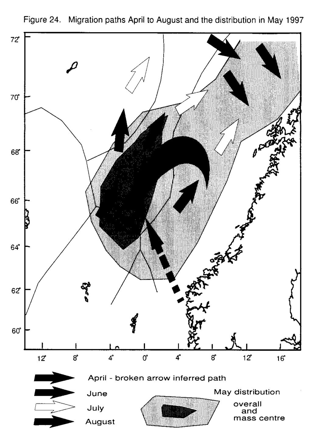
11 June As in April, coverage was only partial in June. In both years concentrations were observed in Faeroese waters (64-66 N, 3-8 W). In 1996 the extension of the distribution into Jan Mayen waters seen in May persisted into June. In 1997 no herring were observed in this area by the acoustic surveys, however surface trawl results indicated the presence of substantial numbers of herring in June. No fish were seen in international waters (66-69 N, 2 E - 4 W) in June In June 1997, reasonable quantities were found in this area. Based on trawl survey data in the Jan Mayen sector and perceptions of the migration trajectory of this stock it seems likely that there were fish in this area in 1996 also, but that these were not picked up by the surveys. July/August By the end of' July in both years the herring had mostly moved into the northern parts of the Norwegian Sea, with only isolated patches left south of 65 N. In 1996 the southern limit for the main herring distribution was around 66 N, and extended to the west to about 0. In 1997 the southern limit was between 68 N and 69 N. The western limit was difficult to define but may have been again around 0. On 25 July a purse seiner made a catch of 150 tonnes of large herring in position, 67 40' N, 14 30' W. A further search did not reveal other schools in the immediate neighbourhood. However, capelin seiners fishing m an area about 20 nautical miles farther to the northeast a few days later found some individual herring of similar size mixed with their capelin catches. A short acoustic survey by an Icelandic research vessel in the second week of August, covering the western part of the East Icelandic Current as well as the outer part of the Icelandic shelf from 65 N in the south to 68 N, 16 W in the north and west, did not locate any herring. Basis for the description of the migration within 1997 The inferred migration path of the herring in 1997 is presented in Figure 24. This figure represents a synopsis of the data collected during The basis for each component is discussed below. In March it is assumed that the herring are still largely in, or near to, their spawning grounds along the Norwegian coast. However, there is some evidence from surveys that some of the population may have already started to migrate out into the deeper waters. By May the surveys show that the population occupies a large area of the Norwegian Sea from N. Between these two times the migration track can only be inferred from partial survey data and from sonar recordings of school velocities. In April there are no fish left on the Norwegian coast and relatively little within nautical miles. The main observations were made in the international waters in the central Norwegian Sea. Sonar tracking has shown that these fish were moving generally SW. So it is assumed that the fish move away from the Norwegian coast, probably in a NW or W direction, and then turn SW into international waters, However, there is some evidence from surveys in April that herring, particularly from the spawning grounds around 60 N, may move more directly towards the international waters. 11
12 As the May distribution is so wide spread, it is assumed that following migration out from the coast the fish then spread out freely throughout the international waters, the northern sector of the Faeroese EEZ and up into the northern Norwegian Sea. Sonar recordings indicate that schools were moving randomly during May. Based on age distributions during the survey, it would appear that the older adult fish move to a western boundary defined by the colder waters at the subarctic front. The fish are progressively younger to the east and norm of this area. On the migration map some return migration from international waters is indicated in May. This was mainly made up of young fish. These may actually have migrated west and then back to the east or simply have travelled slower to the west man the older fish. It is impossible to determine what migrations are occurring in the norm of the area (north of 68 N), however, it seems likely that predominantly young fish are migrating in from the Barents Sea and the Norwegian coast. In June and July survey data is too sparse to properly infer migration paths. Sonar recordings indicate a general NE direction of school movement, and surveys indicate that there were still significant concentrations of fish in Faeroese waters as well as scattered herring in the easternmost part of the Icelandic zone. By August the bulk of the fish are found north of 68 N. In combination, these suggest that the May distribution is largely continued into June and that during this month the fish begin to move NE. By July the bulk of the herring will have left the southern end of the May distribution and was beginning to concentrate north of 66-68'N. In August the fish were almost all found N of 68 N. In previous years the fish have subsequently been caught in September/October dose to the Norwegian coast. So it is assumed that the migration in August probably turns to the east towards the coast. Comparison between migration patterns in 1996 and 1997 In 1996 two distinct categories of herring migrations were observed (Anon. 1996), with immature herring of the 1991 and 1992 year classes migrating far south into the Faeroese, EU and International zones. This particular migration pattern was not observed in 1997, when the now maturing individuals of those two year-classes appeared to have taken up a migration pattern more like the older herring (Fig. 24). Zooplankton and herring interactions Comparison of the present findings on the biomass of Zooplankton in the 0-50 m layer with those of previous years shows that the biomass of Zooplankton recorded during May 1997 (l 10 mg dry wt./m 3 ) was much lower than observed during the same time of year in both 1995 and However, the distribution pattern of the zooplankton biomass during May is somewhat similar during these three years. Thus, the high abundance of zooplankton in the north western part of the survey area is a common pattern for the three years. Furthermore, the observed low in the biomass of zooplankton in the south western and southernmost parts of the survey area seems to be a common feature for the three years of study. In addition, during both 1996 and 1997 relatively low biomass values were observed in the central parts of the study area. It is seen that during the first part of their migration westward across the eastern Norwegian 12
13 Sea, the herring at times feed intensely in deep waters ( m) on the overwintering generation of zooplankton. As the herring enter the central and western Norwegian Sea in May, they appear to search for food at shallower depths. This is reflected in the changes of their vertical distribution which by May has become shallower than in late March and April. As described above, the zooplankton biomass was comparatively low in the central Norwegian Sea In May At the time, this was interpreted a 'vacuum cleaner effect' resulting from the previous passage of huge numbers of herring having just traversed the area. This simple explanation does not apply m 1997, since the herring sampled in the area west of the zero meridian had very little food in their stomachs. However, in both cases the developments of herring movements during the period June-August were similar, i.e. the herring migrated northwards across the western Norwegian Sea to feed in the zooplankton-rich areas near and south of the subarctic front in the northern and north eastern Norwegian Sea. The Zooplankton samples have not yet been properly analysed with regard to the species composition and age-stage structure of the dominant zooplankter, C. finmarchicus. At this stage it is therefore impossible to evaluate whether the observed interannual variability in zooplankton biomass during the years is due to differences in the composition and/or seasonal development and migration of the zooplankton. Variations in ocean climate are likely to influence on the distribution patterns and abundance of the zooplankton and it is noted that much of the area traversed by herring in may 1997,including the central Norwegian Sea, was 1-2 C colder that in Further, one should bear in mind that besides herring there are several other planktivorous species in the area, i.e. mesopelagic fish and, at present, large numbers young of blue whiting, that will affect the biomass and abundance of the herbivorous Zooplankton, which m turn is likely to affect the feeding migration pattern of the herring stock. When interpreting the zooplankton data from the different sources one should bear in mind that the sampling gears and the methods used are not always the same. Therefore the data may not be entirely comparable. However, as discussed in the report for the previous year, this may not be a serious problem. In the future it is, however, desirable that all participating institutes use the same sampling gear. This should be inexpensive and simple to use, e.g. the WP2 net, which is currently in use by two of the participating nations Iceland and the Faeroese Isles). Herring-temperature relationships The temperatures of the uppermost 200 m of the waters of the Norwegian Sea and the East Icelandic Current were low in May Such a Situation at that time of year effectively blocks any herring migrations to the area west of the eastern border of the East Icelandic Current at 6-7 W, at least the surface layers have been considerably warmed by solar radiation. In spite of somewhat milder oceanic climate in the spring of 1996 as compared to 1997, the East Icelandic Current was fairly strong and the bulk of the herring biomass did nor remain in the western Norwegian Sea for long enough to enable them to extend their feeding area to the west in The same is true for most of the stock biomass in 1997, and the available information also suggests that it largely followed a similar route to the northern and north eastern feeding grounds as observed in However, the months of June and July 1997 were very warm in relative terms, and by early August a very strong thermocline had become established in the domain of the East Icelandic 13
14 Current with temperatures of about 7 C in the uppermost 50 m water layer. It appears that some of the oldest and largest herring took advantage of this and remained to feed in the warm nearsurface layer east of 8 W in the area east of Iceland in June and July. In the area between NE Iceland and Jan Mayen these herring were recorded as far west as 14 30' W at latitude 67 40' N, but appeared to have left by early August. Future research The total age-structured estimate of 49 billion individuals, obtained by combining the Norwegian and Russian acoustic data from the May surveys, deviates by less than 5% from the 1997 Northern Pelagic and Blue Whiting Working Group (NPBWG) assessment of the Norwegian spring spawning herring at 54 billion individuals (Anon. 1997b). Such a remarkable similarity between the acoustic estimate and the NPBWWG estimate was also the attained in 1996 (Anon. 1996a). In May the herring were distributed over large areas in the eastern and north eastern parts of the Norwegian Sea as thin undulating scattering layer at a depth between about 25 and 100 m. Because of low spatial variability and negligible acoustic shadowing, this distribution pattern is favourable for acoustic stock assessments. Furthermore, the recordings just described were within the vertical range for which the applied TS relationship was established (Foote 1987). The above observations, as well as those of 1996, indicate that the month of May is a favourable time of year for acoustic assessments of the Norwegian spring spawning herring. However, in the western part of the Norwegian Sea the herring tend to be distributed in large schools at m depth, resulting in large spatial variability. This is the reason for the dense spacing west of the zero meridian, south of 67 30'N. In the area between 0-3 W near 65 N, the herring were also distributed in the near-surface layer, partly above transducer range (i.e. in the acoustically dead zone ). Naturally, such a situation results in an underestimate in the area where it occurs. Both in 1996 and 1997 the Norwegian May estimates were obtained by surveying with a transect spacing of 60 nautical miles. This is usually regarded as too coarse a survey grid for reliable acoustic estimation. However, when combining the S A -recordings of the other survey vessels with the Norwegian ones only minor changes were observed. While this may be coincidental for the western area, it seems that the even distribution in the eastern Norwegian Sea justifies a spacing of 60 nautical miles in the eastern part of the survey area. However, the echo recordings in that part of the survey area should be analysed by a geostatistical method in order to determine an appropriate transect spacing there in May. For future surveys of stock distribution and abundance in May, it is tentatively recommended that they follow an adaptive strategy, starting with coarse coverage (e.g. 60 miles) of the comparatively even distribution in the eastern areas, but a much more closer spacing (e.g. 15 miles) in the western and other areas where clusters or schools are observed. Furthermore, in order to obtain a picture of stock movements in June-August, future surveys should be coordinated in such a way that the entire stock distribution is covered at least twice during this period 14
15 Acknowledgements We are grateful to the crews and scientific personnel who participated in the 10 surveys which made this report possible. References Anon Report on surveys of the distribution and migrations of the Norwegian spring spawning herring and the environment of the Norwegian Sea and adjacent waters in late winter, spring and summer of Marine Research Institute, Reykjavik, Iceland. 11 pp. Anon. 1996a, Report of the Northern Pelagic and Blue Whiting Fisheries Working Group. ICES C.M. 1996/Assess: pp. Anon.l997a. Report of the ICES Planning Group on Surveys on The Pelgic Fish in the Norwegian Sea (PGSPEN). ICES C.M. 1997/H:3. pp Anon. 1997b. Report of the Northern Pelagic and Blue Whiting Fisheries Working Group. ICES C.M. 1997/Assess: pp. Foote, K. G. 1987, Fish target strengths for use in echo integrator surveys. J. Acoust. Soc. Am., 82: Foote, K. G., H. P. Knudsen, R. S. Komeliussen, P. E. Nordbe and K. Rang Post processing System for echo sounder data. J. Acoust. Soc. Am. 90, l: Valdemarsen, J.W. and Misund, O.A Trawl designs and techniques used by Norwegian research vessels to sample fish in the pelagic zone. In Proceedings of the sixth IMR-PINRO Symposium, Bergen, June 1994, Ed. by A. Hylen, pp
16
17
18
19
20 Figure 3. Cruise tracks during the April survey
21 < > Figure 4. Herring distribution in April 1997
22 Figure 5. Cruise tracks for the coordinated surveys in May 1997
23 < > Figure 6. Herring distribution in May 1997
24 < > Figure 7. Mean length of herring in May 1997
25
26
27 Figure 10. Cruise tracks in June 1997
28 < > Figure 11. Herring distribution in June 1997
29
30
31
32
33 < > Figure 17. Temperature at 200 m in May 1997
34 < > Figure 18. Zooplankton distribution in May 1997
35 < > Figure 19. Zooplankton distribution in May 1996
36
37 < > Figure 21. Blue whiting distribution in May 1997
38
39
40
SARSIA SVEINN SVEINBJØRNSSON
 DISTRIBUTION, MIGRATION AND ABUNDANCE OF NORWEGIAN SPRING SPAWNING HERRING IN RELATION TO THE TEMPERATURE AND ZOOPLANKTON BIOMASS IN THE NORWEGIAN SEA AS RECORDED BY COORDINATED SURVEYS IN SPRING AND SUMMER
Cruise Report Cruise no. 06NG-06TG. Exploratory investigations on Norwegian spring-spawning herring in the Norwegian Sea November 2006
 Cruise Report Cruise no. 06NG-06TG Exploratory investigations on Norwegian spring-spawning herring in the Norwegian Sea 17 24 November 2006 M/S Norðborg M/S Tróndur í Gøtu Jan Arge Jacobsen Mourits Mohr
2.3.1 Advice May Capelin in Subareas V and XIV and Division IIa west of 5 W (Iceland East Greenland Jan Mayen area).
.") 2.3.1 Advice May 2014 ECOREGION Iceland and East Greenland STOCK Capelin in Subareas V and XIV and Division IIa west of 5 W (Iceland East Greenland Jan Mayen area) Advice for 2014/2015 ICES advises on
2.3.1 Advice May 2014 ECOREGION Iceland and East Greenland STOCK Capelin in Subareas V and XIV and Division IIa west of 5 W (Iceland East Greenland Jan Mayen area) Advice for 2014/2015 ICES advises on
Distribution and abundance of Norwegian spring spawning herring during the spawning season in 2006
 Toktrapport/Havforskningsinstituttet/ISSN 153-6294/Nr.1-26 «Cruise report» RV Håkon Mosby 16-2.2.26 Distribution and abundance of Norwegian spring spawning herring during the spawning season in 26 by Aril
4.9.5 Norwegian spring-spawning herring
 4.9.5 Norwegian springspawning herring State of the stock Spawning biomass in relation to precautionary limits Acceptable Fishing mortality in relation to precautionary limits Acceptable Fishing mortality
People from FFL: Fróði B. Skúvadal (Cruise leader) and Mourits Mohr Joensen (Technician)
 and Mourits Mohr Joensen (Technician)") Skálaberg Faroese Fisheries Laboratory (FFL) Cruise report Investigations of the pelagic redfish population S.mentella in the Norwegian sea. Cruise nr. 0888 Period: 13-26/8 2008 People from FFL: Fróði
Skálaberg Faroese Fisheries Laboratory (FFL) Cruise report Investigations of the pelagic redfish population S.mentella in the Norwegian sea. Cruise nr. 0888 Period: 13-26/8 2008 People from FFL: Fróði
9.4.5 Advice September Widely distributed and migratory stocks Herring in the Northeast Atlantic (Norwegian spring-spawning herring)
") 9.4.5 Advice September 212 ECOREGION STOCK Widely distributed and migratory stocks Herring in the Northeast Atlantic (Norwegian spring-spawning herring) Advice for 213 ICES advises on the basis of the
9.4.5 Advice September 212 ECOREGION STOCK Widely distributed and migratory stocks Herring in the Northeast Atlantic (Norwegian spring-spawning herring) Advice for 213 ICES advises on the basis of the
Distribution and abundance of Norwegian spring spawning herring during the spawning season in 2007
 Toktrapport/Havforskningsinstituttet/ISSN 153-6294/Nr. 2-27 «Cruise report» MS Gardar 16.2-5.3.27 Distribution and abundance of Norwegian spring spawning herring during the spawning season in 27 by Aril
International Council for the Exploration of the Sea. Pelagic Fish Committee NORWEGIAN BLUE WHITING INVESTIGATION IN APRIL/MAY 1980
 International Council for the Exploration of the Sea C.M., 1980/H 61 Pelagic Fish Committee NORWEGIAN BLUE WHITING INVESTIGATION IN APRIL/MAY 1980 by Terje Monstad and Lars Midttun Institute of Marine
Héctor Peña, Jostein Røttingen, Georg Skaret, Kjell Rong Utne and Leif Nøttestad. Abstract
 Cruise report on northeast Atlantic mackerel (Scomber scombrus) abundance and distribution in the North Sea and west of the British Isles from 1 st to 20 th of October 2012 by Héctor Peña, Jostein Røttingen,
The stock of blue whiting has been surveyed for the last three years during the spawning period using the research vessel cg. 0.
 FiskDir. Skr. Ser. HavUnders., 16: 245-257. ABUNDANCE ESTIMATES OF THE SPAWNING STOCK OF BLUE WHITING (MICR OMESISTIUS PO UTASSOU (RISSO, 1810)) IN THE AREA WEST OF THE BRITISH ISLES IN 1972-1974 By RAMON
Stock characteristics, fisheries and management of Greenland halibut (Reinhardtius hippoglossoides (Walbaum)) in the Northeast Arctic
) in the Northeast Arctic") The 10 th Norwegian Russian Symposium Stock characteristics, fisheries and management of Greenland halibut (Reinhardtius hippoglossoides (Walbaum)) in the Northeast Arctic by Kjell H. Nedreaas (IMR) &
The 10 th Norwegian Russian Symposium Stock characteristics, fisheries and management of Greenland halibut (Reinhardtius hippoglossoides (Walbaum)) in the Northeast Arctic by Kjell H. Nedreaas (IMR) &
Advice June Capelin in Subareas V and XIV and Division IIa west of 5 W (Iceland East Greenland Jan Mayen area).
.") 2.4.12 Advice June 2012 ECOREGION Iceland and East Greenland STOCK Capelin in Subareas V and XIV and Division IIa west of 5 W (Iceland East Greenland Jan Mayen area) Advice for 2013 ICES advises on the
2.4.12 Advice June 2012 ECOREGION Iceland and East Greenland STOCK Capelin in Subareas V and XIV and Division IIa west of 5 W (Iceland East Greenland Jan Mayen area) Advice for 2013 ICES advises on the
Size of mackerel in research vessel trawls and commercial purse-seine catches: implications for acoustic estimation of biomass
 989 Size of mackerel in research vessel trawls and commercial purse-seine catches: implications for acoustic estimation of biomass Aril Slotte, Dankert Skagen, and Svein A. Iversen Slotte, A., Skagen,
Arctic Frontiers, Tromsø, January 24 th Thorbjørn Thorvik, Senior adviser. The Norwegian Directorate of Fisheries.
 Sustainable harvesting at lower trophic levels: The Norwegian management plan for Calanus finmarchicus and the framework for utilizing mesopelagic species Thorbjørn Thorvik, Senior adviser. The Norwegian
6 th Meeting of the Scientific Committee Puerto Varas, Chile, 9-14 September SC6-Doc15 The Russian Federation s Annual Report
 6 th Meeting of the Scientific Committee Puerto Varas, Chile, 9-14 September 2018 SC6-Doc15 The Russian Federation s Annual Report National report of the Russian Federation to the SPRFMO Science Working
Advice June 2012
 2.4.1 Advice June 212 ECOREGION STOCK Iceland and East Greenland Beaked redfish (Sebastes mentella) in Subareas V, XII, and XIV and NAFO Subareas 1+2 (Deep pelagic stock > 5 m) Advice for 213 The advice
9.4.5 Advice October Widely Distributed and Migratory Stocks Herring in the Northeast Atlantic (Norwegian spring-spawning herring)
") 9.4.5 Advice October 21 ECOREGION STOCK Widely Distributed and Migratory Stocks Herring in the Northeast Atlantic (Norwegian spring-spawning herring) Advice for 211 Management Objective (s) Landings in
9.4.5 Advice October 21 ECOREGION STOCK Widely Distributed and Migratory Stocks Herring in the Northeast Atlantic (Norwegian spring-spawning herring) Advice for 211 Management Objective (s) Landings in
Final report on fish diet and stomach analyses
 SALSEA-MERGE FP7-ENV-2007-1 Grant Agreement No 212529 Work Package 4 Deliverable - D 4.3 Final report on fish diet and stomach analyses (Month 40) D 4.3 - Final report on fish diet and stomach analyses
- 2 - MTERL ND METHODS The distribution and density of the pelagic scattering layers was estimated from echo-sounder paper records, from echo integrat
 This paper not to be cited without prior reference to the author ~ p. e~ nternational Council for C.M. 1974/H :33 the Exploration of the Sea Pelagic Fish (Northern) Committee Ref. : Hydrography and Demersal
The South African and Namibian horse mackerel fisheries Prepared by Dave Japp and Melanie Smith. The South African horse mackerel
 The South African and Namibian horse mackerel fisheries Prepared by Dave Japp and Melanie Smith The South African horse mackerel Status of the Fishery and Management Until recently the South African fishery
This paper not to be cited without prior reference to the authors OFF LOFOTEN AND M0RE IN 1984
 (f I 1 This paper not to be cited without prior reference to the authors International Council for the Exploration of the Sea C. M. 1984 /G : 47 Demersal Fish Committee ACOUSTIC ESTIMATES OF SPAWNING COD
The fishery for jack mackerel in the Eastern Central Pacific by European trawlers in 2008 and 2009
 Eighth International Meeting: SWG: Jack Mackerel Sub-Group SP-08-SWG-JM-01 The fishery for jack mackerel in the Eastern Central Pacific by European trawlers in 2008 and 2009 Ad Corten Corten Marine Research
ICES advice on fishing opportunities
 ICES Advice on fishing opportunities, catch, and effort Northeast Atlantic and Arctic Ocean Published 22 October 2018 Version 2: 25 October 2018 https://doi.org/10.17895/ices.pub.4568 Herring (Clupea harengus)
Fish investigations in the Barents Sea winter 2015
 J O I N IMR/PINRO T R E 2 2015 P O R T S E I E R S Fish investigations in the Barents Sea winter 2015 Institute of Marine Research - IMR Polar Research Institute of Marine Fisheries and Oceanography -
A Combined Recruitment Index for Demersal Juvenile Cod in NAFO Divisions 3K and 3L
 NAFO Sci. Coun. Studies, 29: 23 29 A Combined Recruitment Index for Demersal Juvenile Cod in NAFO Divisions 3K and 3L David C. Schneider Ocean Sciences Centre, Memorial University St. John's, Newfoundland,
Serial No. N4503 NAFO SCR Doc. 01/115. SCIENTIFIC COUNCIL MEETING SEPTEMBER 2001 (Deep-sea Fisheries Symposium Poster)
") NOT TO BE CITED WITHOUT PRIOR REFERENCE TO THE AUTHOR(S) Northwest Atlantic Fisheries Organization Serial No. N4503 NAFO SCR Doc. 01/115 SCIENTIFIC COUNCIL MEETING SEPTEMBER 2001 (Deep-sea Fisheries Symposium
NOT TO BE CITED WITHOUT PRIOR REFERENCE TO THE AUTHOR(S) Northwest Atlantic Fisheries Organization Serial No. N4503 NAFO SCR Doc. 01/115 SCIENTIFIC COUNCIL MEETING SEPTEMBER 2001 (Deep-sea Fisheries Symposium
ICES Working Group on the assessment of Mackerel, Horse Mackerel, Sardine and Anchovy. Vigo, 5-15 September 2005 Working Document
 ICES Working Group on the assessment of Mackerel, Horse Mackerel, Sardine and Anchovy. Vigo, 5-15 September 25 Working Document Direct assessment of anchovy by the PELGAS5 acoustic survey Jacques Massé
REPORT OF ICES ADVISORY COMMITTEE NORTH ATLANTIC SALMON STOCKS. NORTH ATLANTIC SALMON CONSERVATION ORGANIZATION NEAC Area
 REPORT OF ICES ADVISORY COMMITTEE ON NORTH ATLANTIC SALMON STOCKS TO NORTH ATLANTIC SALMON CONSERVATION ORGANIZATION NEAC Area CNL(14)8 Advice generated by ICES in response to terms of reference from NASCO
The Iceland Sea: Ecosystem structures and capelin distribution patterns
 The Iceland Sea: Ecosystem structures and capelin distribution patterns Ólafur K. Pálsson, Ástþór Gíslason, Björn Gunnarsson, Hafsteinn Guðfinnsson, Héðinn Valdimarsson, Hildur Pétursdóttir, Konráð Þórisson,
ASSESSMENT OF THE WEST COAST OF NEWFOUNDLAND (DIVISION 4R) HERRING STOCKS IN 2011
 HERRING STOCKS IN 2011") Canadian Science Advisory Secretariat Science Advisory Report 212/24 ASSESSMENT OF THE WEST COAST OF NEWFOUNDLAND (DIVISION 4R) HERRING STOCKS IN 211 Context Figure 1. Map of unit areas of NAFO Division
Canadian Science Advisory Secretariat Science Advisory Report 212/24 ASSESSMENT OF THE WEST COAST OF NEWFOUNDLAND (DIVISION 4R) HERRING STOCKS IN 211 Context Figure 1. Map of unit areas of NAFO Division
3.4.3 Advice June Barents Sea and Norwegian Sea Cod in Subareas I and II (Norwegian coastal waters cod)
") 3.4.3 Advice June 2013 ECOREGION STOCK Barents Sea and Norwegian Sea Cod in Subareas I and II (Norwegian coastal waters cod) Advice for 2014 ICES advises on the basis of the Norwegian rebuilding plan,
3.4.3 Advice June 2013 ECOREGION STOCK Barents Sea and Norwegian Sea Cod in Subareas I and II (Norwegian coastal waters cod) Advice for 2014 ICES advises on the basis of the Norwegian rebuilding plan,
Map Showing NAFO Management Units
 Map Showing NAFO Management Units Biology Are 6 species of seals in Atlantic Canadian waters, all of which occur in Newfoundland Two Arctic Species (Ringed, Bearded) Two temperate (Grey, Harbour) Two migratory
Predator diet as an indicator of comb jellyfish (Ctenophora) abundance dynamics in the Barents Sea
 abundance dynamics in the Barents Sea") Predator diet as an indicator of comb jellyfish (Ctenophora) abundance dynamics in the Barents Sea Eriksen, E. 1, Dolgov, A. 2, Bogstad, B. 1 1 Institute of Marine Research (IMR), Norway 2 Polar Research
Predator diet as an indicator of comb jellyfish (Ctenophora) abundance dynamics in the Barents Sea Eriksen, E. 1, Dolgov, A. 2, Bogstad, B. 1 1 Institute of Marine Research (IMR), Norway 2 Polar Research
The Spatial and Temporal Distribution of Salmon and the Pelagic Fisheries in the North- East Atlantic: A Potential for By-catch?
 The Spatial and Temporal Distribution of Salmon and the Pelagic Fisheries in the North- East Atlantic: A Potential for By-catch? Marianne Holm 1, Árni Ísaksson 2, Jan Arge Jacobsen 3, Lars Petter Hansen
12 Capelin in the Iceland-East Greenland-Jan Mayen area
 372 ICES NWWG REPORT 2015 12 Capelin in the Iceland-East Greenland-Jan Mayen area Summary In May 2014 ICES advised on the basis of precautionary considerations that the initial quota be set at the 50%
Strategy for sustainable harvesting of mesopelagic species
 Strategy for sustainable harvesting of mesopelagic species Thorbjørn Thorvik, Senior adviser. The Norwegian Directorate of Fisheries North Atlantic Seafood Forum, Bergen, March 7 th 2017 Lanternfish -
Co-Principal Investigators Stephen C. Jewett, Ph.D. Paul C. Rusanowski, Ph.D.
 PROGRESS REPORT FACTORS AFFECTING NEARSHORE SURVIVAL AND PRODUCTION OF JUVENILE SOCKEYE SALMON FROM KVICHAK BAY Phase I: Important habitat, migration routes and food resources CoPrincipal Investigators
SCIENTIFIC COUNCIL MEETING SEPTEMBER Status of Skate Stocks in the Barents Sea (Elasmobranch Fisheries Poster)
") NOT TO BE CITED WITHOUT PRIOR REFERENCE TO THE AUTHOR(S) Northwest Atlantic Fisheries Organization Serial No. N4713 NAFO SCR Doc. 2/92 SCIENTIFIC COUNCIL MEETING SEPTEMBER 22 Status of Skate Stocks in
NOT TO BE CITED WITHOUT PRIOR REFERENCE TO THE AUTHOR(S) Northwest Atlantic Fisheries Organization Serial No. N4713 NAFO SCR Doc. 2/92 SCIENTIFIC COUNCIL MEETING SEPTEMBER 22 Status of Skate Stocks in
Pelagic fishery for Sebastes mentella in the Irminger Sea
 3.2.6.d Pelagic fishery for Sebastes mentella in the Irminger Sea The stock structure of deep-sea redfish S. mentella in Sub-area XII, Division Va and Sub-area XIV and NAFO Div. 1F remains generally uncertain.
Fishing mortality in relation to highest yield. Fishing mortality in relation to agreed target
 3.4 Stock summaries 3.4. Northeast Arctic cod State of the stock Spawning biomass in relation to precautionary limits Full reproductive capacity Fishing mortality in relation to precautionary limits/management
Preliminary results of SEPODYM application to albacore. in the Pacific Ocean. Patrick Lehodey
 SCTB15 Working Paper ALB-6 Preliminary results of SEPODYM application to albacore in the Pacific Ocean Patrick Lehodey Oceanic Fisheries Programme Secretariat of the Pacific Community Noumea, New Caledonia
Report of the Working Group on Widely Distributed
 ICES WGWIDE REPORT 2017 ICES ADVISORY COMMITTEE ICES CM 2017/ACOM:23 Report of the Working Group on Widely Distributed Stocks (WGWIDE) 30 August -5 September 2017 ICES Headquarters, Copenhagen, Denmark
North East Atlantic Fisheries Baltic Sprat Whitepaper March 2011
 North East Atlantic Fisheries Baltic Sprat Whitepaper March 2011 1. Introduction Sprat is a clupeid fish found widely in the North East Atlantic area. Sprat is a relatively short-lived species. The stock
Blue whiting (Micromesistius poutassou) in subareas 1 9, 12, and 14 (Northeast Atlantic and adjacent waters)
 in subareas 1 9, 12, and 14 (Northeast Atlantic and adjacent waters)") ICES Advice on fishing opportunities, catch, and effort Ecoregions of the Northeast Atlantic and Arctic Ocean Published 28 September 2018 nea https://doi.org/10.17895/ices.pub.4536 Blue whiting (Micromesistius
ICES Advice on fishing opportunities, catch, and effort Ecoregions of the Northeast Atlantic and Arctic Ocean Published 28 September 2018 nea https://doi.org/10.17895/ices.pub.4536 Blue whiting (Micromesistius
LAKE WASHINGTON SOCKEYE SALMON STUDIES. Richard E. Thorne and James J. Dawson
 FRI-UW-7613 October 1976 LAKE WASHINGTON SOCKEYE SALMON STUDIES 1975 1976 by Richard E. Thorne and James J. Dawson Final Report Service Contract No. 648 Washington State Department of Fisheries For the
Spurdog (Squalus acanthias) in the Northeast Atlantic
 in the Northeast Atlantic") ICES Advice on fishing opportunities, catch, and effort Northeast Atlantic Published 11 October 2016 9.3.17 Spurdog (Squalus acanthias) in the Northeast Atlantic ICES stock advice ICES advises that when
ICES Advice on fishing opportunities, catch, and effort Northeast Atlantic Published 11 October 2016 9.3.17 Spurdog (Squalus acanthias) in the Northeast Atlantic ICES stock advice ICES advises that when
Fine-Scale Survey of Right and Humpback Whale Prey Abundance and Distribution
 DISTRIBUTION STATEMENT A. Approved for public release; distribution is unlimited. Fine-Scale Survey of Right and Humpback Whale Prey Abundance and Distribution Joseph D. Warren School of Marine and Atmospheric
NOTIFICATION OF PROPOSED RESEARCH CRUISE
 1 NOTIFICATION OF PROPOSED RESEARCH CRUISE PART A: GENERAL 1. NAME OF RESEARCH SHIP: "G.O.Sars" CRUISE NO. 2012102 2. DATES OF CRUISE From: 15 February 2012 To: 14 March 2012 3. OPERATING AUTHORITY: Institute
Effects of juvenile nursery on geographic spawning distribution in Norwegian spring-spawning herring (Clupea harengus L.)
") ICES Journal of Marine Science, 55: 987 996. 1998 Article No. jm980371 Effects of juvenile nursery on geographic spawning distribution in Norwegian spring-spawning herring (Clupea harengus L.) J. C. Holst
ICES Journal of Marine Science, 55: 987 996. 1998 Article No. jm980371 Effects of juvenile nursery on geographic spawning distribution in Norwegian spring-spawning herring (Clupea harengus L.) J. C. Holst
Herring in the North Sea, Exploitation and Conservation. Presentation by Dr Beatriz A. Roel
 Herring in the North Sea, Exploitation and Conservation Presentation by Dr Beatriz A. Roel Geographic Distribution of Atlantic and Pacific herring Herring reproduction Herring use external fertilization
Northeast Atlantic Mackerel, Handlines
 Northeast Atlantic Mackerel, Handlines Northeast Atlantic Mackerel, Handlines Content last updated 3rd Apr 2017 Stock: Mackerel (Scomber scombrus) in subareas 1 7 and 14, and in divisions 8.a e and 9.a
Hydroacoustic survey of Otsego Lake, 2004
 Hydroacoustic survey of Otsego Lake, 2004 Thomas E. Brooking 1 Mark D. Cornwell 2 INTRODUCTION Fishery managers must often rely on uncertain information regarding abundance and distribution of offshore
PROBABLE DISCARDS OF COD IN THE BARENTS SEA AND AJACENT WATERS DURING RUSSIAN BOTTOM TRAWL
 unuftp.is Final Project 2002 PROBABLE DISCARDS OF COD IN THE BARENTS SEA AND AJACENT WATERS DURING RUSSIAN BOTTOM TRAWL Konstantin Sokolov Knipovich Polar Research Institute of Marine Fisheries and Oceanography
THE CIRCULATION IN THE NORTERN PART OF THE DENMARK STRAIT AND ITS VARIABILITY ABSTRACT
 ICES em 19991L:06 THE CIRCULATION IN THE NORTERN PART OF THE DENMARK STRAIT AND ITS VARIABILITY Steingrimur J6nsson Marine Research Institute and University of Akureyri, Glenirgata 36, 600 Akureyri, Iceland,
INVESTIGATIONS ON DEMERSAL FISH IN THE BARENTS SEA WINTER 2001 Detailed report
 INVESTIGATIONS ON DEMERSAL FISH IN THE BARENTS SEA WINTER Detailed report Institute of Marine Research IMR Polar Research Institute of Marine Fisheries and Oceanography PINRO This report should be cited
Cod distribution and temperature in the North Sea
 ICES mar. Sei. Symp., 198: 244-. 1994 Cod distribution and temperature in the North Sea Henk Heessen and Niels Daan Heessen, H. J. L., and Daan, N. 1994. Cod distribution and temperature in the North Sea.
SCIENTIFIC COMMITTEE SEVENTH REGULAR SESSION August 2011 Pohnpei, Federated States of Micronesia
 SCIENTIFIC COMMITTEE SEVENTH REGULAR SESSION 9-17 August 2011 Pohnpei, Federated States of Micronesia CPUE of skipjack for the Japanese offshore pole and line using GPS and catch data WCPFC-SC7-2011/SA-WP-09
Hydroacoustic surveys of Otsego Lake s pelagic fish community,
 Hydroacoustic surveys of Otsego Lake s pelagic fish community, 2010 1 Holly A. Waterfield 2 and Mark Cornwell 3 INTRODUCTION Hydroacoustic surveys were conducted in May and November 2010 to estimate pelagic
West Coast of Newfoundland Atlantic Herring (Division 4R)
") DFO Science Stock Status Report B-1 5 59 5 57 QUEBEC LOWER NORTH SHORE 51 Meters Ra STRAIT OF BELLE NEW FEROLLE ST. JOHN'S BAY POINT RICHE West Coast of Newfoundland Atlantic Herring (Division R) 5 BEAUGE
DFO Science Stock Status Report B-1 5 59 5 57 QUEBEC LOWER NORTH SHORE 51 Meters Ra STRAIT OF BELLE NEW FEROLLE ST. JOHN'S BAY POINT RICHE West Coast of Newfoundland Atlantic Herring (Division R) 5 BEAUGE
Feeding ecology of herring and mackerel in Icelandic waters
 Workshop on the Future Potential of Zooplankton and Mesopelagic Species October 1st - 2nd 2018, Reykjavík, Iceland Feeding ecology of herring and mackerel in Icelandic waters and other aspects of relevance
FISHERIES CO-OPERATION ICELAND AND NORWAY WITH. Presented by Philip Rodgers ERINSHORE ECONOMICS
 FISHERIES CO-OPERATION WITH ICELAND AND NORWAY Presented by Philip Rodgers 17/12/2013 Fisheries Cooperation with Norway and Iceland 1 Objective To consider the current situation in the fishery for highly
Overview 10/8/2015. October Pelagic Advice Pelagic AC 7 October 2015
 October Pelagic Advice Pelagic AC 7 October 2015 John Simmonds ICES ACOM Vice Chair Overview WG 1 Blue whiting NSS herring North Sea horse makerel WG 2 Stocks Northeast Atlantic mackerel Western horse
Beaked redfish (Sebastes mentella) in subareas 1 and 2 (Northeast Arctic)
 in subareas 1 and 2 (Northeast Arctic)") ICES Advice on fishing opportunities, catch, and effort Arctic Ocean, Barents Sea, Faroes, Greenland Sea, Published 13 June 2017 Icelandic Waters, and Norwegian Sea Ecoregions DOI: 10.17895/ices.pub.3212
ICES Advice on fishing opportunities, catch, and effort Arctic Ocean, Barents Sea, Faroes, Greenland Sea, Published 13 June 2017 Icelandic Waters, and Norwegian Sea Ecoregions DOI: 10.17895/ices.pub.3212
Currents measurements in the coast of Montevideo, Uruguay
 Currents measurements in the coast of Montevideo, Uruguay M. Fossati, D. Bellón, E. Lorenzo & I. Piedra-Cueva Fluid Mechanics and Environmental Engineering Institute (IMFIA), School of Engineering, Research
Blue whiting (Micromesistius poutassou) in subareas 1 9, 12, and 14 (Northeast Atlantic and adjacent waters)
 in subareas 1 9, 12, and 14 (Northeast Atlantic and adjacent waters)") ICES Advice on fishing opportunities, catch, and effort Ecoregions of the Northeast Atlantic and Arctic Ocean Published 29 September 2017 DOI: 10.17895/ices.pub.3030 Blue whiting (Micromesistius poutassou)
ICES Advice on fishing opportunities, catch, and effort Ecoregions of the Northeast Atlantic and Arctic Ocean Published 29 September 2017 DOI: 10.17895/ices.pub.3030 Blue whiting (Micromesistius poutassou)
Marine Mammals in Faroese Waters
 Marine Mammals in Faroese Waters With Special Attention to the South-south-eastern Sector of the Region by Dorete Bloch 1, Bjarni Mikkelsen 2 and Lise H. Ofstad 2 1 Museum of Natural History 2 Faroese
JIMAR PFRP ANNUAL REPORT FOR FY 2006
 JIMAR PFRP ANNUAL REPORT FOR FY 2006 P.I./Sponsor Name: Michael P. Seki and Jeffrey J. Polovina Project Proposal Title: Oceanographic Characterization of the American Samoa Longline Fishing Grounds for
Working Document. Working Group on International Pelagic Surveys Tenerife, Spain, January 2019
 Working Document Working Group on International Pelagic Surveys Tenerife, Spain, January 2019 Working Group on Widely Distributed Stocks Copenhagen, Denmark, September 2018 INTERNATIONAL BLUE WHITING SPAWNING
Section 6. The Surface Circulation of the Ocean. What Do You See? Think About It. Investigate. Learning Outcomes
 Chapter 5 Winds, Oceans, Weather, and Climate Section 6 The Surface Circulation of the Ocean What Do You See? Learning Outcomes In this section, you will Understand the general paths of surface ocean currents.
Observing the behavioral response of herring exposed to mid-frequency sonar signals
 Observing the behavioral response of herring exposed to mid-frequency sonar signals Handegard 1, Nils Olav and Doksaeter 1, Lise and Godoe 1, Olav Rune and Kvadsheim 2, Petter H. 1 Institute of Marine
Southern Gulf of St. Lawrence (4T) Herring
 Herring") Stock Status Report 24/23 Southern Gulf of St. Lawrence (4T) Herring Background Herring are a pelagic species which form schools during feeding and spawning periods. Herring in the southern Gulf of St.
Stock Status Report 24/23 Southern Gulf of St. Lawrence (4T) Herring Background Herring are a pelagic species which form schools during feeding and spawning periods. Herring in the southern Gulf of St.
Sprat (Sprattus sprattus) in Division 3.a (Skagerrak and Kattegat)
 in Division 3.a (Skagerrak and Kattegat)") ICES Advice on fishing opportunities, catch, and effort Greater North Sea Ecoregion Published 07 April 2017 DOI: 10.17895/ices.pub.3256 Sprat (Sprattus sprattus) in Division 3.a (Skagerrak and Kattegat)
ICES Advice on fishing opportunities, catch, and effort Greater North Sea Ecoregion Published 07 April 2017 DOI: 10.17895/ices.pub.3256 Sprat (Sprattus sprattus) in Division 3.a (Skagerrak and Kattegat)
6 th Meeting of the Scientific Committee Puerto Varas, Chile, 9-14 September SC6-Doc19 Peru s Annual Report, part I (SPRFMO Area) IMARPE PRODUCE
 IMARPE PRODUCE") 6 th Meeting of the Scientific Committee Puerto Varas, Chile, 9-14 September 2018 SC6-Doc19 Peru s Annual Report, part I (SPRFMO Area) IMARPE PRODUCE INSTITUTO DEL MAR DEL PERU IMARPE MINISTERIO DE LA
6 th Meeting of the Scientific Committee Puerto Varas, Chile, 9-14 September 2018 SC6-Doc19 Peru s Annual Report, part I (SPRFMO Area) IMARPE PRODUCE INSTITUTO DEL MAR DEL PERU IMARPE MINISTERIO DE LA
The International Ecosystem survey in the Nordic Seas in April/May R/V DANA Cruise No. 5/ Calibration of Echo-sounders 24/4 26/4 2012
 1 The International Ecosystem survey in the Nordic Seas in April/May 2012 R/V DANA Cruise No. 5/20120 Calibration of Echo-sounders 24/4 26/4 2012 International Acoustic Monitoring of Herring and Blue whiting
3.4 Stock Summaries Advice June 2011
 3.4 Stock Summaries 3.4.1 Advice June 211 ECOREGION STOCK Barents Sea and Norwegian Sea Cod in Subareas I and II (Northeast Arctic cod) Advice for 212 ICES advises on the basis of the Joint Russian Norwegian
and found that there exist a significant overlap between the billfish resources and the exploitation activities targeting tunas and mahi mahi.
 Executive Summary Report 2016 Billfish Research in the Eastern Pacific Ocean Rosenstiel School of Marine and Atmospheric Science University of Miami January 2017 During 2016, the Eastern Pacific Ocean
Why has the cod stock recovered in the North Sea?
 Why has the cod stock recovered in the North Sea? Summary The expansion of European fisheries during the 1970s and 1980s resulted in high fishing pressure on stocks of cod, haddock, whiting and saithe
Leif Nøttestad, Øyvind Tangen and Svein Sundby
 Possible mechanisms and explanations for the drastic decline and disappearance of Atlantic bluefin tuna in the Norwegian fisheries since the early 1960s: What went wrong and what can we do? Leif Nøttestad,
Serial No. N6173 NAFO SCR Doc. 13/020 SCIENTIFIC COUNCIL MEETING JUNE 2013
 NOT TO BE CITED WITHOUT PRIOR REFERENCE TO THE AUTHOR(S) Northwest Atlantic Fisheries Organization Serial No. N6173 NAFO SCR Doc. 13/020 SCIENTIFIC COUNCIL MEETING JUNE 2013 SOME ASPECTS OF POSSIBLE CONSEQUENCES
Effects of climate change on fish spawning grounds and larvae drift. Frode Vikebø Risør
 Effects of climate change on fish spawning grounds and larvae drift Frode Vikebø frovik@imr.no Risør 15.08.2012 Objectives What are the prerequisites for modelling drift, growth and survival of early stages
Sound scattering by hydrodynamic wakes of sea animals
 ICES Journal of Marine Science, 53: 377 381. 1996 Sound scattering by hydrodynamic wakes of sea animals Dmitry A. Selivanovsky and Alexander B. Ezersky Selivanovsky, D. A. and Ezersky, A. B. 1996. Sound
Extract from the project Dynamic Mapping of North Sea Spawning - the KINO Report 2016 Statoil contract no
 Extract from the project Dynamic Mapping of North Sea Spawning - the KINO Report 2016 Statoil contract no. 4503121426 5.3.1 Sandeels Ammodytidae - tobis There are five species of sandeel in the North Sea
Wednesday, September 27, 2017 Test Monday, about half-way through grading. No D2L Assessment this week, watch for one next week
 Wednesday, September 27, 2017 Test Monday, about half-way through grading No D2L Assessment this week, watch for one next week Homework 3 Climate Variability (due Monday, October 9) Quick comment on Coriolis
SCIENTIFIC COUNCIL MEETING - JUNE Polish Research Report, by A. J. Paciorkowski Sea Fisheries Institute Gdynia Poland.
 NOT TO BE CITED WITHOUT PRIOR REFERENCE TO THE,SECRETARIAT Northwest Atlantic Fisheries Organization Serial No. N17 NAFO SCS Doc. 80/VI/ SCIENTIFIC COUNCIL MEETING JUNE 1980 Polish Research Report, 1979
Beaked redfish (Sebastes mentella) in subareas 1 and 2 (Northeast Arctic)
 in subareas 1 and 2 (Northeast Arctic)") ICES Advice on fishing opportunities, catch, and effort Arctic Ocean, Barents Sea, Faroes, Greenland Sea, Published 28 September 2018 Icelandic Waters, and Norwegian Sea Ecoregions DOI: 10.17895/ices.pub.4538
ICES Advice on fishing opportunities, catch, and effort Arctic Ocean, Barents Sea, Faroes, Greenland Sea, Published 28 September 2018 Icelandic Waters, and Norwegian Sea Ecoregions DOI: 10.17895/ices.pub.4538
FAO Congress Director Spain; Hildegunn Fure Osmundsvåg 06/10/2017
 FAO Congress 2017 Director Spain; Hildegunn Fure Osmundsvåg 06/10/2017 Kilde ; The institute of marine research 06.10.2017 Presentasjonstittel 2 The Norwegian Seafood Council Who are we? Established in
Stock Abundance and Size Compositions of the Neon Flying Squid in the Central North Pacific Ocean during
 Stock Abundance and Size Compositions of the Neon Flying Squid in the Central North Pacific Ocean during 1979 1998 Akihiko Yatsu 1, Junta Mori 1, Hiroyuki Tanaka 1, Tomowo Watanabe 1, Kazuya Nagasawa 1,
Recent trends in distribution and abundance of commercial fish stocks in Lake Victoria (East Africa) based on GIS
 based on GIS") Recent trends in distribution and abundance of commercial fish stocks in Lake Victoria (East Africa) based on GIS representation from Acoustic surveys 1 Taabu A. M, 2 R. Tumwebaze and 3 R. Kayanda 1 National
Recent trends in distribution and abundance of commercial fish stocks in Lake Victoria (East Africa) based on GIS representation from Acoustic surveys 1 Taabu A. M, 2 R. Tumwebaze and 3 R. Kayanda 1 National
Mackerel (Scomber scombrus) in subareas 1 8 and 14, and in Division 9.a (the Northeast Atlantic and adjacent waters)
 in subareas 1 8 and 14, and in Division 9.a (the Northeast Atlantic and adjacent waters)") ICES Advice on fishing opportunities, catch, and effort Ecoregions in the Northeast Atlantic and Arctic Ocean Published 29 September 2017 DOI: 10.17895/ices.pub.3023 Mackerel (Scomber scombrus) in subareas
ICES Advice on fishing opportunities, catch, and effort Ecoregions in the Northeast Atlantic and Arctic Ocean Published 29 September 2017 DOI: 10.17895/ices.pub.3023 Mackerel (Scomber scombrus) in subareas
EU request on management areas for sandeel in the North Sea
 ICES Special Request Advice Greater North Sea Ecoregion Published 18 January 2018 DOI: 10.17895/ices.pub.3877 EU request on management areas for sandeel in the North Sea Advice summary ICES advises that
NAFO/ICES PANDALUS ASSESSMENT GROUP MEETING OCTOBER An overview of Norwegian investigations of the shrimp stock off East Greenland in
 NOT TO BE CITED WITHOUT PRIOR REFERENCE TO THE AUTHOR(S) Northwest Atlantic Fisheries Organization Serial No. N5595 NAFO SCR Doc. 08/063 NAFO/ICES PANDALUS ASSESSMENT GROUP MEETING OCTOBER 2008 An overview
While oil and gas is the nations largest export product in value, fish is the second largest. Both activities are crucial for the Norwegian economy.
 Oil and fish in Norwegian waters conflict or coexistence? Kristoffersen Arne, Norwegian Coastal Fishermen Union representative, Norway 1. Presentation: Arne Helge Kristoffersen: Representative from the
Cruise report. The international acoustic survey in the Norwegian Sea in May R/V DANA Cruise No. 4/2009. Calibration of Echo-sounders
 Cruise report The international acoustic survey in the Norwegian Sea in May 2009 R/V DANA Cruise No. 4/2009 Calibration of Echo-sounders 28/4 30/4 2009 International Acoustic Monitoring of Herring and
Stock Annex: Greater silver smelt (Argentina silus) in divisions 5.b and 6.a (Faroes grounds and west of Scotland)
 in divisions 5.b and 6.a (Faroes grounds and west of Scotland)") ICES Stock Annex 1 Stock Annex: Greater silver smelt (Argentina silus) in divisions 5.b and 6.a (Faroes grounds and west of Scotland) Stock specific documentation of standard assessment procedures used
ICES Stock Annex 1 Stock Annex: Greater silver smelt (Argentina silus) in divisions 5.b and 6.a (Faroes grounds and west of Scotland) Stock specific documentation of standard assessment procedures used
Can trawling effort be identified from satellite-based VMS data?
 Not to be cited without prior reference to the author International Council for the Exploration of the Seas Theme session N: Technologies for monitoring fishing activities and observing catch Can trawling
REDFISH in Sub-areas I and II. Nominal catch (t) by countries in Sub-area I, Divisions IIa and IIb combined as officially reported to ICES.
 by countries in Sub-area I, Divisions IIa and IIb combined as officially reported to ICES.") .1. Redfish in Sub-areas I and II Table.1..1 REDFISH in Sub-areas I and II. Nominal catch (t) by countries in Sub-area I, Divisions IIa and IIb combined as officially reported to ICES. Year Can Den Faroe
.1. Redfish in Sub-areas I and II Table.1..1 REDFISH in Sub-areas I and II. Nominal catch (t) by countries in Sub-area I, Divisions IIa and IIb combined as officially reported to ICES. Year Can Den Faroe
Ocean Circulation. Si Hui Lee and Frances Wen. You can access ME at
 Ocean Circulation Si Hui Lee and Frances Wen You can access ME at http://tinyurl.com/oceancirculation Earth - the blue planet - 71% area covered by the oceans - 3/4 of ocean area between 3000-6000m deep
ATLANTIC SALMON NEWFOUNDLAND AND LABRADOR, SALMON FISHING AREAS 1-14B. The Fisheries. Newfoundland Region Stock Status Report D2-01
 Fisheries Pêches and Oceans et Océans DFO Science Newfoundland Region Stock Status Report D2-01 ATLANTIC SALMON NEWFOUNDLAND AND LABRADOR, SALMON FISHING AREAS 1-14B Background There are 15 Atlantic salmon
SA2 + Div. 3K Redfish
 Fisheries and Oceans Pêches et Océans Canada Canada DFO Science Stock Status Report A2-15(21) entered the fishery in 1975 and averaged about 16,5 t from 1978-1986. The steady reduction in catches from