! " # $ % & % & ' ( ) * +
|
|
|
- Wendy Carr
- 5 years ago
- Views:
Transcription
1 !" #$%& %& '() *+


2 EnVision Manistee County Fact Book Manistee County Community Foundation Spring 2005 Natural Environment & Recreation Page 1
3 Commercial Lodging Many of Manistee County s visitors choose to stay in some type of commercial lodging establishment. Much like other counties in Northern Lower Michigan, Manistee County sees the majority of its commercial lodging stays in the summer months, with the most significant activity occurring in July and August. Chart 3: Number of Commercial Lodging Establishments, 2000 Hotel/Motel/Lodge/Historic Inn 16 Cabin/Cottage/Condo/Rental 20 Bed & Breakfast Chart 4: Number of Guest Rooms in Commercial Lodging Establishments, 2000 Hotel/Motel/Lodge/Historic Inn 390 Cabin/Cottage/Condo/Rental 277 Bed & Breakfast Source: Michigan State University Extension. Manistee County Tourism Profile Page 15
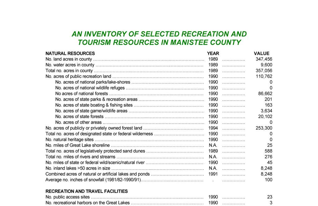
4 Public Parks & Lands Varying from roadside parks to national forests, there are a number of public parks and lands in Manistee County, including: 1st Street Beach Manistee. Arboretum Wellston. Arcadia Beach Lake Michigan, Arcadia. Bar Lake Outlet Bar Lake. Brethren Village Park Brethren. Cooly Bridge Norman Township. Copemish Village Park Copemish. Crystal Lake Beach Wellston. Dickson Township Park Dickson Township. Dorner Lake Wellston. Douglas Park/First Street Beach Lake Michigan, Manistee. Duffy Park Manistee. Eastlake Village Park Eastlake. Fifth Avenue Beach Lake Michigan, Manistee. Hopkins Park Bear Lake. Magoon Creek Beach Lake Michigan, Manistee. Manistee National Forest Manistee River State Park Maple Grove Park Kaleva. Orchard Beach State Park Lake Michigan, Manistee. Pere Marquette State Forest. Pierport Beach Lake Michigan, Onekama. Portage Point Lake Michigan, Onekama. Pleasanton Township Park Pleasanton. Page 16
5 Campgrounds Campers represent a significant share of Michigan s overall pleasure travel market (10%). Manistee County is ranked 6th in regards to the market share of the most frequently visited counties by campers to Michigan. Camping parties are larger (4.3 vs. 3.7 persons), are younger (33.4 vs years old), far more likely to contain children (64.9% vs. 50.7%), and come from households with incomes of less than $50,000 (59.6% vs. 49%) than non-camper pleasure travelers. Campers spend less per trip on average than do non-campers ($401 vs. $559); however, when lodging expenditures are factored out, both groups spend the same amount ($268) per trip on non-lodging purchases. Chart 5: Number of Campgrounds, 2000 Commercial 24 Municipal 2 Township County 0 0 State Forest State Park 1 1 National Forest Chart 6: Number of Campsites, 2000 Commercial 1218 Municipal 68 Township County State Forest State Park 175 National Forest Source: Michigan State University Extension. Manistee County Tourism Profile Page 17

6 Fishing & Boating Manistee County is known for its abundance of fishing and boating opportunities throughout the County. In 2004, it was estimated that 1,352 fishing charters took place resulting in direct expenditures of almost 1 million dollars. Each charter is estimated to $ per charter. More data is needed to fully understand the entire impact sportfishers have on Manistee County. Map 9: Trout Locations Page 18
7 Fishing & Boating cont. Selected Inland Lakes There are 9 inland lakes in Manistee county with an area greater than 50 acres in size. There are 8,248 acres of natural or artificial lakes and ponds in Manistee County. Some of those lakes include: Arcadia Lake (Deep water port) Location: M-22 in Arcadia. Fish include: Northern Pike, Largemouth and Smallmouth Bass, Brown Trout in spring and fall, and spring run of Steelhead. Bar Lake Location: East side of Lakeshore Drive (M-110). Fish include: Northern Pike, Largemouth and Smallmouth Bass. Bear Lake Location: U.S. 31 in Bear Lake. Fish include: panfish, Walleye Pike, Northern Pike, Largemouth and Smallmouth Bass. Canfield Lake Location: Maple Road 2.5 miles south of Manistee, access on Canfield Road on left side. Fish include: panfish, Largemouth Bass and Northern Pike. Crystal Lake Location: From M-55 in downtown Wellston take Seaman Road south less than 1 mile, lake on west side of Seaman Road (no motor boats are allowed). Dorner (Long Lake) Location: From M-55 east of Wellston take S. Snyder Road south 1.5 miles, lake on west side of S. Snyder. Fish include: panfish and Largemouth Bass. Eleanor Lake Location: From High Bridge Road in downtown Brethren, travel east on Coates Hwy., lake on left hand side less than.5 miles. Fish include: Largemouth and Smallmouth Bass and panfish (no motorboats allowed). Healy Lake Location: From Bear Lake take 13 Mile Road east to Healy Lake Road to Plagany Rd., turn right to next gravel road and follow signs to campgrounds. Fish include: panfish, Largemouth and Smallmouth Bass. Lemon Lake Location: From Kaleva take Healy Lake Road three miles north to Potter Road, go east on Potter Road 2 miles to Niemi Rd. Go south on Niemi Road less than.5 mi. to Thompsonville Rd. about 2 miles to Lemon Lake. Fish include: Panfish, Largemouth and Smallmouth Bass. Manistee Lake (Deep water port) Location: City of Manistee. Fish include: panfish, Northern Pike, Largemouth and Smallmouth Bass, Walleye Pike, Muskellunge, Salmon in the fall, Steelhead in the fall and spring. Page 19
8 Fishing & Boating cont. Selected Inland Lakes cont. Pine Lake Location: From the west, take M-55 east 17 miles from its junction with U.S. 31 in Manistee, then right at Wellston on Bosschem Rd. for 1.1 miles, then right on Pine Lake Rd. 2.6 miles to the campground. Fish include: panfish, Cisco, Brown Trout and Largemouth Bass. Portage Lake Location: Off M-22 in Onekama. Deep water access to Lake Michigan. Fish include: panfish, Perch, Northern Pike, Walleye Pike, Smallmouth and Largemouth Bass, fall run of salmon, Brown Trout and Steelhead in winter and spring. Round (Chittenden) Lake Location: From M-55 in Wellston take S. Baker Rd. south less than.5 miles to first dirt road on left - take road less than.5 mi. to Round (Chittenden) Lake. Fish include: Largemouth and Smallmouth Bass, Bluegill and Perch. Sand Lake Location: From M-55 in Wellston follow Seaman Rd. 4.5 miles south through Dublin to entrance road, right on Forest Service Rd to the campground. Fish include: panfish, Largemouth Bass, Rainbow and Brown Trout. (Only boats that can be hand carried for launching are allowed). Timmerman Lake Location: From M-55 west of Wellston travel south on East Udell Hills Rd. 2 miles to a dirt road on east side of road, it then dead ends into the lake. Fish include: panfish, Largemouth and Smallmouth Bass. Tippy Dam Backwaters Location: High Bridge Road to downtown Brethren travel east on Coates Hwy. 3.5 miles to Dilling Rd., travel south on Dilling Rd. until it dead ends into Tippy Dam, launch site is on the left. From Wellston go north on M-55 on Snyder Rd. to Robinson Road. Take Robinson Road to its east end. There is another launch at Red Bridge on Coates Hwy. 7.5 miles east of Brethren. Fish include: Northern Pike, Muskellunge, Walleye Pike, Rainbow and Brown Trout, Largemouth and Smallmouth Bass, and panfish. Page 20
9 Fishing & Boating cont. Selected Rivers It is estimated that there are 276 miles of rivers and streams in Manistee County. There are 45 miles of state or federal wild/scenic/natural rivers in Manistee County. Manistee County is well-known for the Big Manistee River, which is most famous for its salmon and steelhead fishing, but its scenery also draws thousands of people there every year, too. In Manistee County, the Manistee River begins at Hodenphyl Dam in Marilla Township and exits to Manistee Lake in the City of Manistee. The majority of the Manistee River is surrounded by the Manistee National Forest. Other rivers in Manistee County, offering a variety of gamefish and boating opportunities, include: Betsie River Location: Thompsonville Rd. (east) to Moore Rd. (west) to Springdale Rd. (south), Springdale Township. The Betsie River Fish include: Salmon, Steelhead, Brown Trout, Rainbow Trout. Little Manistee River Location: Campbell Rd. (east) to Stronach Rd. (west), Stronach Township. The Little Manistee is a low-gradient river well-known for its scenery and is wadeable throughout its length. Fish include: Salmon, Steelhead, Brown Trout, Rainbow Trout. Pine River Location: County #1 Rd. (east) to M-55 (west), Norman Township. The Pine River is a high-gradient stream dropping an average 10 feet per mile while flowing through Osceola, Lake, Wexford, and Manistee Counties before emptying into the Tippy Dam backwaters of the Manistee River. The Pine River traverses a variety of water conditions, having many sharp bends, short choppy riffles, and passable log and debris jams. The Pine also has a section with class 2 white water rapids. Fish include: Brook, Brown, and Rainbow Trout. Page 21
10 Hiking & Biking In 1992, it was estimated that there existed 82 miles of hiking, skiing, and biking trails in Manistee County. There are several trail systems in Manistee County that allow a variety of uses, some of these trail systems include: Arboretum Trail Bosschem and Pine Lake roads, Wellston. Big M Cross-Country Ski/Mountain Bike Trails 30 kilometers of trails, 27 miles of single-track mountain bike trails. East Udell Hills Road, 4 miles south of M-55, Manistee National Forest. Lake Bluff Audubon Center 70 acres of meadows, Lake Michigan beach and arboretum. Hiking only. Manistee. Manistee River Trail 10 miles, Manistee National Forest. North Country National Scenic Trail Manistee River ridge, off M-55 in Udell or in Marilla from Beers Road. Orchard Beach State Park 2 miles north of Manistee on M-110. Marzinski Horse Trail 20-mile trail, two trailheads, one campground. Between Wellston and Manistee, Manistee National Forest. Page 23

11
12
13
14
Trail and Driving Directions
 Trail and Driving Directions GETTING TO THE START: FROM CADILLAC: Follow M-55 west from US131 for 20.9 miles to the corner of M-37 and M-55 FROM THE INTERSECTION OF M-55 AND M-37: Head west on M-55 2.7
2016 North Country Trail Relay Updated Event Instructions Jan 2016
 Welcome to the 2016 North Country Trail Relay (NCTR). organized by Bev Chesebro and Doug Bostian The race is run on the North Country National Scenic Trail, which is a footpath that one day will stretch
Michigan Dept. of Natural Resources Status of the Fishery Resource Report Page 1. Weber Lake Cheboygan County, T34N, R3W, Sec.
 Michigan Dept. of Natural Resources 2012-143 Status of the Fishery Resource Report Page 1 Weber Lake Cheboygan County, T34N, R3W, Sec. 31 Neal Godby, Fisheries Biologist Environment Weber Lake is a 28.5-acre
BIG TWIN LAKE Kalkaska County (T28N, R05W, Section 18, and T28N, R06W, Section 13) Surveyed May 1999
 Surveyed May 1999") Michigan Department of Natural Resources Status of the Fishery Resource Report No. 2001-1, Year 2001 BIG TWIN LAKE Kalkaska County (T28N, R05W, Section 18, and T28N, R06W, Section 13) Surveyed May 1999
Michigan Department of Natural Resources Status of the Fishery Resource Report No. 2001-1, Year 2001 BIG TWIN LAKE Kalkaska County (T28N, R05W, Section 18, and T28N, R06W, Section 13) Surveyed May 1999
RECREATION. in the St. Paul District. Your safety is our concern ALWAYS wear a LIFE VEST
 RECREATION in the St. Paul District Your safety is our concern ALWAYS wear a LIFE VEST Cross La RECREATION in the St. Paul District CANADA NORTH DAKOTA Lake of the Woods Homme Lake Devils Lake Red River
Thunder Bay River Assessment Appendix. Appendix 2
 Appendix 2 Known past and present fish distributions in the River system. Distribution of fishes were compiled from Bailey et al. (2003) and from records located at the Michigan Department of Natural Resources
Quemahoning Reservoir
 Pennsylvania Fish & Boat Commission Biologist Report Quemahoning Reservoir Somerset County May 2011 Trap Net, Gill Net and Electrofishing Survey Quemahoning Reservoir is an 899 acre impoundment located
RIVER SEGMENTS. Manistee River Assessment. Figure 1. The Manistee River watershed in northwestern lower Michigan. Seg 1 Deward.
 Manistee River ssessment RIVER SEGMENTS Seg 1 - Headwaters to M-72 Seg 2 - M-72 to Smithville (M-66) Seg 3 - Smithville (M-66) to M-115 Bridge Seg 4 - Hodenpyl Dam to Red Bridge (oates Hwy) Seg 5 - Tippy
Waterfront Development Rare Opportunity on Lake Wallenpaupack
 Waterfront Development Rare Opportunity on Lake Wallenpaupack White Sands Springs - Lake Wallenpaupack, Tafton, PA This site, consisting of 229.6 acres presents a dream project for a builder to develop
(date are inclusive)
") Kind of Fish and Locality Methods Permitted Open Season (date are inclusive) Bag Limit Maximum or Minimum Size Limits (a) LARGE MOUTH AND SMALLMOUTH BASS. (i) All waters Hook & Line ice fishing (including
Kind of Fish and Locality Methods Permitted Open Season (date are inclusive) Bag Limit Maximum or Minimum Size Limits (a) LARGE MOUTH AND SMALLMOUTH BASS. (i) All waters Hook & Line ice fishing (including
Crawford Reservoir. FISH SURVEY AND MANAGEMENT INFORMATION Eric Gardunio, Fish Biologist Montrose Service Center
 FISH SURVEY AND MANAGEMENT INFORMATION General Information: Crawford Reservoir is a popular fishery that provides angling opportunity for yellow perch, channel catfish, northern pike, rainbow trout, black
Elk Lake, Antrim and Grand Traverse counties T. 28, 29 N., R. 8, 9 W., Sec. many. Lake surveys. began at 40 feet
 Elk Lake, Antrim and Grand Traverse counties T. 28, 29 N., R. 8, 9 W., Sec. many Physical and chemical data surveyed August 1931 Temperature ( F) Secchi disk (feet) 9. 6 Surface 74 Bottom 45 PH 8.0 Thermocline
Androscoggin River Trail Access Sites. Mahoosucs. 168 miles from its source at Lake Umbagog to Merrymeeting Bay
 Androscoggin River Trail Access Sites Mahoosucs 168 miles from its source at Lake Umbagog to Merrymeeting Bay Trail Under Construction More than 40 Public Access Sites Available Androscoggin River Watershed
50 places. 60 minutes. to go fishing within. of Roseburg
 * Directions and times are approximate. 50 places to go fishing within 60 minutes of Roseburg Let s go fishing on Saturday. Not enough time to go fishing? Think again if you live in the Roseburg area,
62. Gulkana River, Main Fork, Middle Fork, and West Fork
 62. Gulkana River, Main Fork, Middle Fork, and West Fork The Gulkana, a National Wild and Scenic River, is one of Alaska s most popular whitewater rivers because of its road accessibility and because of
Appendix 2. Miscellaneous Historical Creel Data. References
 Appendix 2 Miscellaneous Historical Creel Data This appendix contains miscellaneous creel data from 1928-1964 for the Kalamazoo River and tributaries. Angler hours, catch by species, total catch, catch
207 Bear Hill Road, Brookfield, VT
 207 Bear Hill Road, Brookfield, VT Curtis Trousdale, Owner, Broker, Realtor Cell: 802-233-5589 curtis@preferredpropertiesvt.com 2004 Williston Road, South Burlington VT 05403 www.preferredpropertiesvt.com
Tahquamenon River Assessment Appendix
 DNR DEPARTMENT OF NATURAL RESOURCES MICHIGAN STATE OF MICHIGAN DEPARTMENT OF NATURAL RESOURCES SR45 Appendix February 2008 Tahquamenon River Assessment Appendix James R. Waybrant and Troy G. Zorn www.michigan.gov/dnr/
Stocking Summary for Lake Michigan
 Lake Michigan Committee Meeting Windsor, Ontario March 23, 2006 Stocking Summary for Lake Michigan 1976-2005 Prepared by: Dale Hanson U.S. Fish & Wildlife Service Green Bay Fishery Resources Office 2661
Brook Trout Angling in Maine2009 Survey Results
 Maine State Library Maine State Documents Resource Management Documents Inland Fisheries and Wildlife 5-3-2010 Brook Trout Angling in Maine2009 Survey Results Marc Edwards University of Maine Cooperative
Canoe Route. Dogtooth Lake-Highwind Lake-Dryberry Lake- Lake of the Woods-Blindfold Lake
 1 Canoe Route Dogtooth Lake-Highwind Lake-Dryberry Lake- Lake of the Woods-Blindfold Lake This is an interesting and challenging route starting and ending at Rushing River Provincial Park. It passes over
6TH PELLETIER BROOK LAKE T15 R9, Aroostook Co. U.S.G.S. Gardner Pond, Maine (7 1/2 )
") 6TH PELLETIER BROOK LAKE T15 R9, Aroostook Co. U.S.G.S. Gardner Pond, Maine (7 1/2 ) Fishes Brook trout Minnows Blacknose dace Pearl dace Physical Characteristics Area - 27 acres Average depth - 2 feet
6TH PELLETIER BROOK LAKE T15 R9, Aroostook Co. U.S.G.S. Gardner Pond, Maine (7 1/2 ) Fishes Brook trout Minnows Blacknose dace Pearl dace Physical Characteristics Area - 27 acres Average depth - 2 feet
Gamefish Assessment Report
 MINNESOTA DEPARTMENT OF NATURAL RESOURCES Gamefish Assessment Report Spring Gamefish Assessment on the Mississippi River from Little Falls to Brainerd, MN May 31 through June 4, 2013 River Miles 966 to
Family Fun. Adventure Game! Official Game Book. page 1
 Family Fun Adventure Game! Official Game Book page 1 Family Fun Adventure Game KEY MAP and Driving Directions ^ N Ocoee River 2 mi 5 km 68 Copper Hill McCaysville old 2 2 Ducktown 5 1 3 Blue Ridge TENN.
Canoe Trip # Maps: 63L Amisk Lake 63M Pelican Narrows
 Canoe Trip #51 49 Southeast Arem Deschambault Lake - Pelican Narrows - Wunehikun Bay - Attitti Lake - Belcher Lake - Mukoman Lake - Ohoo Lake - Mukoman River - Sokatisewin Lake - Sandy Bay 170 Kilometers
Macutagon Creek to Russell s Landing
 Day Trips Macutagon Creek to Russell s Landing Manitouwadge Public Consultation Committee Canoe Route #13 #13 MACUTAGON CREEK TO RUSSELL S LANDING This route is suitable to all levels of paddlers but due
Stocking Summary for Lake Michigan
 Lake Michigan Committee Meeting Ypsilanti, Michigan March 20-21, 2007 Stocking Summary for Lake Michigan 1976-2006 Prepared by: Dale Hanson U.S. Fish & Wildlife Service Green Bay Fishery Resources Office
2018 Greenway Challenge. Up River Course Maps and Cue Sheets
 2018 Greenway Challenge Up River Course Maps and Cue Sheets Segment 1 2 laps with in- water mass start for 2.7 mile Open Water Paddle (2x 1.35 mile loop) on Olney Pond at Lincoln Woods State Park, Lincoln,
STUDY PERFORMANCE REPORT
 STUDY PERFORMANCE REPORT State: Michigan Study No.: 427 Project No.: F-81-R-1 Title: Measurement of sportfishing harvest in lakes Michigan, Huron, Erie, and Superior Period Covered: October 1, 1999 to
Fish Community. Fish Habitat, Streams and Rivers
 Clear, Ston(e)y and White Lake Plan Fish Community The lakes support a cool/warm water fishery including muskellunge, walleye, largemouth and smallmouth bass, yellow perch, pumpkinseed, rockbass, blue
Fishing Forecast White Mountains. Fishing Rating: Hot Good Fair Poor. Clear Creek Reservoir -- Rating:
 Fishing Forecast White Mountains Fishing Rating: Hot Good Fair Poor Clear Creek Reservoir -- Rating: As winter weather cools water temperatures, warmwater species like largemouth bass, sunfish, catfish
65 pl aces. to go fishing. in Lane County. Common Fish. If you have more time and a boat.
 62. Munsel Landing County Park, Munsel Lake, yellow perch, bass Popular for boating, swimming and fishing, this shore dune lake offers varied fishing opportunities. Shoreline is mostly privately owned;
East Metro Forest Lake (2,251 acres): Coon Lake (1,481 acres):
: Coon Lake (1,481 acres):") East Metro Forest Lake (2,251 acres): Located within the City of Forest Lake and just east of Interstate 35, Forest Lake boasts good numbers of northern pike and walleye. Northern pike and walleye were
East Metro Forest Lake (2,251 acres): Located within the City of Forest Lake and just east of Interstate 35, Forest Lake boasts good numbers of northern pike and walleye. Northern pike and walleye were
Crooked Lake Oakland County (T4N, R9E, Sections 3, 4, 9) Surveyed May James T. Francis
 Surveyed May James T. Francis") Michigan Department of Natural Resources Status of the Fishery Resource Report No. 2004-1, 2004 Crooked Lake Oakland County (T4N, R9E, Sections 3, 4, 9) Surveyed May 2002 James T. Francis Environment Crooked
Michigan Department of Natural Resources Status of the Fishery Resource Report No. 2004-1, 2004 Crooked Lake Oakland County (T4N, R9E, Sections 3, 4, 9) Surveyed May 2002 James T. Francis Environment Crooked
2010 Fishing Opener Prognosis. Central Region
 2010 Fishing Opener Prognosis Central Region Hinckley PINE COUNTY Pokegama, Cross, Island, Oak and North and South Big Pine Lakes are typically the best lakes for targeting walleye in Pine County. They
Rolling Knolls Pond Population Survey
 Located near the town of Elgin on the west side of Rohrssen Rd. between Illinois Route 58 and U.S.- 20. This small 1.8 acre pond has a maximum depth of 7.5 feet and is occasionally influenced by Poplar
DRIVING TOURS. Grays Harbor County is a fisherman s dream! Fish the bay, ocean, streams, rivers or lakes... the choice is yours!
 Grays County is a fisherman s dream! bay, ocean, streams, rivers or lakes... the choice is yours! Grays offers excellent fresh and saltwater fishing in all seasons. Fish in the open ocean for tuna, halibut,
MINNESOTA DEPARTMENT OF NATURAL RESOURCES DIVISION OF FISHERIES AND WILDLIFE. Gamefish Assessment Report
 Minnesota DNR F-29-R(P) Area F312 February 1, 2013 MINNESOTA DEPARTMENT OF NATURAL RESOURCES DIVISION OF FISHERIES AND WILDLIFE Gamefish Assessment Report Spring Gamefish Assessment on the Mississippi
Bode Lake - South Population Survey
 Bode Lake - South Survey Located in Hoffman Estates on the north side of Bode Rd. 1 mile west of Barrington Rd. Bode Lake is made up of two lakes along Poplar Creek; the larger and deeper Bode Lake South
50 places. of Medford. to go fishing within 60 minutes
 * Directions and times are approximate. 50 places to go fishing within 60 minutes of Medford Let s go fishing on Saturday. Not enough time to go fi shing? Think again if you live in the Medford area, there
Oregon 2011 Regional Visitor Report Mt. Hood Columbia River Gorge
 Oregon 2011 Regional Visitor Report Mt. Hood Columbia River Gorge Introduction Longwoods International began tracking American travelers in 1985, and has conducted large-scale syndicated visitor research
STUDY PERFORMANCE REPORT. Project No.: F-81-R-4
 STUDY PERFORMANCE REPORT State: Michigan Study No.: 646 Project No.: F-81-R-4 Title: Inland creel surveys Period Covered: October 1, 2002 to September 30, 2003 Study Objective: To provide a consistent
DALE HOLLOW LAKE TROOPER ISLAND IMPROVEMENT PROJECT Proposal for Reservoir Fisheries Habitat Partnership (RFHP)
") DALE HOLLOW LAKE TROOPER ISLAND IMPROVEMENT PROJECT Proposal for Reservoir Fisheries Habitat Partnership (RFHP) A. Applicant Information: US Army Corps of Engineers, Dale Hollow Lake POC: Gregg Nivens
DALE HOLLOW LAKE TROOPER ISLAND IMPROVEMENT PROJECT Proposal for Reservoir Fisheries Habitat Partnership (RFHP) A. Applicant Information: US Army Corps of Engineers, Dale Hollow Lake POC: Gregg Nivens
Michigan Department of Natural Resources Status of the Fishery Resource Report Page 1
 Michigan Department of Natural Resources 2007-33 Status of the Fishery Resource Report Page 1 Grand Sable Lake Alger County, T49N, R14W, Sec. Many Lake Superior watershed, last year surveyed 2004 James
HUBBARD LAKE Alcona County (T27N, R7E; T28N, R7E) Surveyed May and September Tim A. Cwalinski
 Surveyed May and September Tim A. Cwalinski") Michigan Department of Natural Resources Status of the Fishery Resource Report No. 2003-1, 2003 HUBBARD LAKE Alcona County (T27N, R7E; T28N, R7E) Surveyed May and September 1996 Tim A. Cwalinski Environment
Michigan Department of Natural Resources Status of the Fishery Resource Report No. 2003-1, 2003 HUBBARD LAKE Alcona County (T27N, R7E; T28N, R7E) Surveyed May and September 1996 Tim A. Cwalinski Environment
Fishing Forecast White Mountains
 Fishing Forecast White Mountains Fishing Rating: Hot Good Fair Poor Clear Creek Reservoir - Rating: Rainbow trout stocked in spring should be fished out by now. Instead, target warmwater species like largemouth
2500 Notch Road, Orange, VT
 2500 Notch Road, Orange, VT Curtis Trousdale, Owner, Broker, Realtor Cell: 802-233-5589 curtis@preferredpropertiesvt.com 147 Knight Lane, Williston, VT 05495 www.preferredpropertiesvt.com Phone: (802)
Lake St. Clair Fish Community and Fishery
 Lake St. Clair Fish Community and Fishery Megan Belore Ontario Ministry of Natural Resources and Forestry Mike Thomas Michigan Department of Natural Resources Fish Community Fish Community Mixture of warm
Maple Lake Population Survey
 Maple Lake Survey Located in Willow Springs approximately 1 mile west of Willow Springs Rd. (104 th Ave.) at Wolf Rd. and 95 th St. Constructed in the 1920 s this 60 acre lake drops down to 20.4 feet in
Faler Creek Ranch DANIEL, WYOMING. Fly Fishing Hunting Ranching Conservation
 Faler Creek Ranch DANIEL, WYOMING Fly Fishing Hunting Ranching Conservation Faler Creek Ranch DANIEL, WYOMING Introduction: Faler Creek Ranch is comprised of 91 acres, providing stunning views of the Wyoming
Busse Reservoir South Lateral Pool Population Survey
 Busse Reservoir South Lateral Pool Survey Located in Elk Grove Village south of Higgins Rd. between RT 53/I-290 and Arlington Heights Rd. Busse Reservoir is comprised of three pools making up a total of
STUDY PERFORMANCE REPORT
 STUDY PERFORMANCE REPORT State: Michigan Study No.: 427 Project No.: F-81-R-2 Title: Measurement of sportfishing harvest in lakes Michigan, Huron, Erie, and Superior Period Covered: October 1, 2000 to
Sport Fishing Expenditures and Economic Impacts on Public Lands in Washington
 Sport Fishing Expenditures and Economic Impacts on Public Lands in Washington For: Northwest Sportfishing Industry Association By: Southwick Associates Released June 2015 PO Box 6435 Fernandina Beach,
Rivers Of Sand: Fly Fishing Michigan And The Great Lakes Region By Josh Greenberg READ ONLINE
 Rivers Of Sand: Fly Fishing Michigan And The Great Lakes Region By Josh Greenberg READ ONLINE Abstract: Brook trout are native to Lake Michigan and many of its where juvenile fish leave Great Lakes tributaries
Michigan Department of Natural Resources Status of the Fishery Resource Report Page 1
 Michigan Department of Natural Resources 2009-78 Status of the Fishery Resource Report Page 1 Grand River Webber Fish Ladder 2008 Report Ionia, T7N, R5W, Sec. 33 Grand River, 2008 Jackie Taylor and Jay
FOR SALE: ¾+ Acre Lake Lot on Bass Lake
 Birchwood, Wisconsin (Loch Lomond) FOR SALE: ¾+ Acre Lake Lot on Bass Lake Now s your chance to own over ¾ of an acre on Bass Lake within the Loch Lomond development just outside of Birchwood, Wisconsin.
I. OUTDOOR RECREATION AND WILDLIFE
 I. OUTDOOR RECREATION AND WILDLIFE 1. Update on National Trends (Table I-1) Table I-1 contains data from the U.S. Fish & Wildlife s 2011 National Survey Fishing, Hunting, and Wildlife-Associated Recreation,
Best Bets for Ohio Fishing
 Best Bets for Ohio Fishing by Dan Armitage Ohio anglers enjoy year-round fishing action, and some months the opportunities are so varied that you need to organize your efforts to take full advantage of
Climbing on the Gunflint Trail
 Climbing on the Gunflint Trail Grand Marais, MN Version 0.5 Copyright 2016 Carter Stritch The Gunflint Trail and the surrounding area is a fantastic and beautiful place. The abundance of lakes, swamps,
Wampum Lake Population Survey
 Wampum Lake Survey Located in Thornton on Thornton-Lansing Rd. 1½ mile west of Torrence Ave. Wampum Lake is 35 acres is size and has a maximum depth of 14.1 feet. Northern pike, largemouth bass, bluegill,
Floating the Buffalo National River. with First River Outfitter. Michelle Hulett. exp2010_w01h3buffalo2_ann_solution
 Floating the Buffalo National River with First River Outfitter Michelle Hulett The Buffalo River Beginning as just a trickle, The Buffalo National River runs down the Boston Mountains, flows north and
Fisheries Survey of White Rapids Flowage, Marinette County Wisconsin during Waterbody Identification Code
 Fisheries Survey of White Rapids Flowage, Marinette County Wisconsin during 25 Waterbody Identification Code 6343 Michael Donofrio Fisheries Supervisor Wisconsin Department of Natural Resources Peshtigo,
Appendix Michigan Family Fish Consumption Guide: Charts of Specific Advisories
 Appendix 3 2003 Michigan Family Fish Consumption Guide: Charts of Specific Advisories 2003 MICHIGAN FAMILY FISH CONSUMPTION GUIDE Important facts to know if you eat Michigan fish MDCH is an Equal Opportunity
Alcona Dam Pond Alcona County (T25N, R5E, Sections various) Surveyed June 6-12 and September 16, 2003
 Surveyed June 6-12 and September 16, 2003") Michigan Department of Natural Resources Status of the Fishery Resource Report No. 2004-6, Year 2004 Alcona Dam Pond Alcona County (T25N, R5E, Sections various) Surveyed June 6-12 and September 16, 2003
Michigan Department of Natural Resources Status of the Fishery Resource Report No. 2004-6, Year 2004 Alcona Dam Pond Alcona County (T25N, R5E, Sections various) Surveyed June 6-12 and September 16, 2003
O Malley s Ponds Population Survey
 O Malley s Ponds Survey The newest fishing lake within the Forest Preserves of Cook County, O Malley Ponds were acquired by the District in 2005. Located in Sauk Village at the intersection of Sauk Trail
Northern Minnesota's. Making Minnesota Memories
 Northern Minnesota's Making Minnesota Memories To Bemidji Making Minnesota Memories Lake Andrusia Grand Forks 29 Fargo Bemidji 94 Cass Lake Lodge 371 St. Cloud 2 Duluth Wolf Lake Minneapolis Minnesota
Northern Minnesota's. Making Minnesota Memories
 Northern Minnesota's Making Minnesota Memories To Bemidji Making Minnesota Memories Lake Andrusia Grand Forks 29 Fargo Bemidji 94 Cass Lake Lodge 371 St. Cloud 2 Duluth Wolf Lake Minneapolis Minnesota
Falls Lake Trail (A part of the NC Mountains-to-Sea Trail) East to West
 East to West") Falls Lake Trail (A part of the NC Mountains-to-Sea Trail) East to West Section 1 (Falls of the Neuse Rd to Raven Ridge Rd) 0.0 mi Parking area of the Tailrace Fishing Area, just below the dam, off Falls
Falls Lake Trail (A part of the NC Mountains-to-Sea Trail) East to West Section 1 (Falls of the Neuse Rd to Raven Ridge Rd) 0.0 mi Parking area of the Tailrace Fishing Area, just below the dam, off Falls
Welcome to Northern Vermont Introduction 11 Geography and Geology 14 Natural History 19 Northern Vermont History 27 General Topics 29
 Welcome to Northern Vermont Introduction 11 Geography and Geology 14 Natural History 19 Northern Vermont History 27 General Topics 29 Parking and Access 29 Customs 29 Water Regime and Prediction 31 Water
About Rend Lake Marina:
 PRICE GREATLY REDUCED TO $1,495,000.00 For Sale: Rend Lake Marina plus 18 Contiguous Waterfront Acres for Development (Approved by the US Corp of Engineers). Rend Lake Marina 8955 West Dam Lane Benton
Claytor Lake View of the Claytor Lake dam from Claytor Lake State Park s boat ramp.
 Claytor Lake 2007 Imagine yourself on a waterbody that is more like a wide river than a lake. When you do, you will have a picture of Claytor Lake. Claytor Lake, a 4,475-acre reservoir, stretches northeastward
LAKE DIANE Hillsdale County (T8-9S, R3W, Sections 34, 3, 4) Surveyed May Jeffrey J. Braunscheidel
 Surveyed May Jeffrey J. Braunscheidel") Michigan Department of Natural Resources Status of the Fishery Resource Report No. 2003-4, 2003 LAKE DIANE Hillsdale County (T8-9S, R3W, Sections 34, 3, 4) Surveyed May 2001 Jeffrey J. Braunscheidel Environment
Michigan Department of Natural Resources Status of the Fishery Resource Report No. 2003-4, 2003 LAKE DIANE Hillsdale County (T8-9S, R3W, Sections 34, 3, 4) Surveyed May 2001 Jeffrey J. Braunscheidel Environment
Green Lake Population Survey
 Located next to the Green Lake Aquatic Center in Calumet City on the north side of 159 th St, east of Torrence Ave. Size can be deceiving; this 5 acre lake is the deepest lake in the District with a maximum
Fall Fishing in the White Mountains By Diane Tilton, AZGFD
 Fall Fishing in the White Mountains By Diane Tilton, AZGFD With the leaves beginning to change colors and a noticeable crispness to the air, fall is almost upon us in the White Mountains. With the cooler
Restoring a Recreational Gem. Pete Jopke Water Resources Planner Dane County Land & Water Resources Department
 Restoring a Recreational Gem Pete Jopke Water Resources Planner Dane County Land & Water Resources Department Lake Park Association 1912 Land purchased, road constructed and dam built Late Fall 1912 January
SELBY RANCH CALIFORNIA, YUBA COUNTY, BROWNS VALLEY. Recreational Haven in Northern California with Excellent Fishing and Hunting
 SELBY RANCH CALIFORNIA, YUBA COUNTY, BROWNS VALLEY Recreational Haven in Northern California with Excellent Fishing and Hunting This beautiful 1,812-acre ranch is located in the Gold Country Foothills
Swift Current Creek Watershed
 Swift Current Creek Watershed Watershed Boundary Gross drainage area 3939 km 2 973,343 acres Gross creek length 230 km 143 miles Primary water source for 20 000 people Major source of water base recreation
Cedar River Paddling Trips Otranto, through Charles City, to Janesville Canoes, Kayaks, and SUPs Charles City Chamber of Commerce.
 Cedar River Paddling Trips Otranto, through Charles City, to Janesville Canoes, Kayaks, and SUPs Charles City Chamber of Commerce Paddle the Cedar In addition to the whitewater course in Charles City,
In South Walton County, on the choctawhatchee bay...
 In South Walton County, on the choctawhatchee bay... Surrounded by water and within minutes of Emerald Coast beaches. Live Oak Landing is a secret attraction, tucked away on its own little peninsula a
Tampier Lake Population Survey
 Located in Palos Park on 131 st St. between Wolf and Will-Cook Rd. s. Tampier Lake has 131 acres of fishable water, with a maximum depth of 9.4 feet. Walleye, northern pike, largemouth bass and channel
Alaska Recreation Survey 2013
 Alaska Recreation Survey 2 Alaska Outdoor Recreation (page 2) Thank you for helping us learn more about outdoor recreation activities in Alaska. The next four pages contain questions about your snow machining,
Overview. Deer Tracks Ranch
 Overview is an idyllic natural setting for corporate seminars, meetings and gatherings. Carved into some 1600 pristine acres of northern Michigan wilderness, Deer Tracks Conference Center is a spacious,
Stocking Summary for Lake Michigan
 Lake Michigan Committee Meeting Niagara Falls, Ontario March 20, 2008 Stocking Summary for Lake Michigan 1976-2007 Dale Hanson U.S. Fish & Wildlife Service Green Bay National Fish & Wildlife Conservation
NE Region 2017 Fishing opener report
 NE Region 2017 Fishing opener report New walleye regulation are in effect on on Lake Vermilion allowing more harvest of walleye, with the protected slot limit moved from 18-26 inches to 20-26 inches. The
HANGING ROCK STATE PARK EXPANSION MASTER PLAN PHASE TWO INITIAL CONCEPTS INSTRUCTIONS
 ABOUT THE PROJECT The Master Plan for the Expansion of Hanging Rock State Park will create a vision for the nearly 750 acres of land added to the park in 2014. The new property includes Vade Mecum, which
GREEN RIVER - FLAMING GORGE
 GREEN RIVER - FLAMING GORGE Rating: Class 3 CFS Range: 800-7,500 Length: 1-2 days Gear: Standard Rafting Gear Maps: Dutch John, UT; Goslin Mountain, UT; Clay Basin, UT; Warren Draw, UT; Swallow Canyon,
FOR SALE: ¾+ Acre Lake Lot on Bass Lake
 Birchwood, Wisconsin (Loch Lomond) FOR SALE: ¾+ Acre Lake Lot on Bass Lake Now s your chance to own over ¾ of an acre on Bass Lake within the Loch Lomond development just outside of Birchwood, Wisconsin.
10000 Bluntnose minnow. White sucker Blacknose shiner. Northern pike Carp Silver shiner Tadpole madtom
 10000 Bluntnose minnow Common shiner umber of individuals 1000 100 potfin shiner chub hite sucker Blacknose shiner Bluegill Blacknose dace Hornyhead chub Rock bass and shiner chub pottail shiner Golden
WISCONSIN DEPARTMENT OF NATURAL RESOURCES FISH MANAGEMENT ACTIVITIES DELAVAN LAKE SPRING 2012
 WISCONSIN DEPARTMENT OF NATURAL RESOURCES FISH MANAGEMENT ACTIVITIES DELAVAN LAKE SPRING 212 Electrofishing and fyke net surveys were conducted on Delavan Lake March 2-May 3, 212. Fyke netting and electrofishing
Mark A. Tonello and Ralph L. Hay
 Michigan Department of Natural Resources Status of the Fishery Resource Report No. 2003-3, 2003 Fife Lake Grand Traverse County (T25N, R09W, Section 13) Surveyed June 4-8, 2001 Mark A. Tonello and Ralph
Apalachicola River Blueway
 Apalachicola River Blueway The Apalachicola River is one of the most beautiful streams of North America, formed at the northern border of Florida by the junction of the Chattahoutchie and the Flint River;
Charter Boat Catch and Effort from the Michigan Waters of the Great Lakes, 1998
 STATE OF MICHIGAN DEPARTMENT OF NATURAL RESOURCES Number 2001-4 February 26, 2003 Charter Boat Catch and Effort from the Michigan Waters of the Great Lakes, 1998 Gerald P. Rackoczy and Donna Wesander-Russell
Mark A. Tonello. Environment
 Michigan Department of Natural Resources Status of the Fishery Resource Report No. 2004-3, 2004 Betsie River Benzie County (T25N, R13W, Section 17 and T25N, R14W, Sections 24, 35) and Manistee County (T24N,
Minong Area Ski Trails
 Minong Area Ski Trails 7. Beaver Brook Ski Trail Spooner College Street Park Spooner 14. Douglas County Ski Trails Solon Springs 18. Hatchery Park Trail Hayward Hayward Golf Course Hayward 20. Heartwood
Arrowhead Lake Population Survey
 Located in Palos Heights at 135 th St, east of Harlem Ave. Arrowhead Lake is a 13 acre body of water with a maximum depth of 12.6 feet. Fish species found in this lake include largemouth bass, bluegill,
Douglas A. Ormseth Shortgrass Web Development
 Douglas A. Ormseth Shortgrass Web Development doug@shortgrass.com 406-261-1115 (Note: others have proposed some of these ideas already in the Black Eagle Community Visioning document and on the Rivers
Basin Water Use Profile - Recreation
 TECHNICAL MEMORANDUM SUBJECT: PREPARED BY: Basin Water Use Profile - Recreation Sunrise Engineering, Inc. DATE: July 15, 2002 Introduction: There is a significant amount of recreational activity within
FISHERIES MANAGEMENT. Georgia Freshwater Fisheries. Department of Natural Resources Wildlife Resources Division
 FISHERIES MANAGEMENT Georgia Freshwater Fisheries Fishing in Georgia 1.4 million resident anglers fish in Georgia. Fishing in Georgia generates $1.3 billion in retail sales and a $2.1 billion ripple effect
Fish Friendly Crossings- Examples from Nash Stream
 Fish Friendly Crossings- Examples from Nash Stream Maggie Machinist- North Regional Forester, Division of Forests and Lands. Nash Stream Nash Stream Forest is 40,000 acres, owned and managed by NH Division