SEABED SURVEY - POTENTIAL SABLE SUBSEA SATELLITES DEVELOPMENT
|
|
|
- Shauna Lang
- 6 years ago
- Views:
Transcription
1
2 Environmental Assessment SEABED SURVEY - POTENTIAL SABLE SUBSEA SATELLITES DEVELOPMENT March 2010 Submitted by: ExxonMobil Canada Properties Prepared by: Hurley Environment Ltd. In association with Stantec Consulting
3 Table of Contents 1 INTRODUCTION PROJECT DESCRIPTION GENERAL INFORMATION General Contacts Required Authorizations / Permits for the Project triggering CEAA PROJECT INFORMATION: SEABED SURVEY Project Components Project Activities Management of Routine Discharges / Emissions / Solid Waste Environmental Protection Systems PROJECT SITE INFORMATION Environmental Features Ocean Use ENVIRONMENTAL ASSESSMENT SCOPING REGULATORY CONTEXT OTHER RELEVANT DOCUMENTS REVIEWED FOR ISSUES SCOPING PLANNED CONSULTATION / COMMUNICATIONS PROGRAM SELECTION OF VALUED ENVIRONMENTAL COMPONENTS (VECS) INTERACTION OF PROJECT ACTIVITIES WITH VECS ASSESSMENT BOUNDARIES DATA GAPS AND UNCERTAINTIES EVALUATION OF SIGNIFICANCE OF ENVIRONMENTAL EFFECTS SUMMARY AND CONCLUSIONS ENVIRONMENTAL EFFECTS ASSESSMENT EFFECTS ON SPECIES AT RISK (SAR) Northern Bottlenose Whale, Blue Whale and Leatherback Turtle Cusk and Winter Skate Roseate Tern EFFECTS ON COMMERCIAL FISH AND FISHERIES Ocean Quahog and Snow crab Commercial fisheries and DFO research surveys IMPACT ON SPECIAL AREAS: SABLE ISLAND AND THE GULLY MPA Sable Island Gully Marine Protected Area EFFECTS OF THE ENVIRONMENT ON THE PROJECT PHYSICAL ENVIRONMENT CLIMATE CHANGE ICEBERGS, SEA ICE, SUPERSTRUCTURE ICING SEISMICITY & TSUNAMIS SEDIMENT TRANSPORT AND SEABED STABILITY CONCLUSIONS CUMULATIVE EFFECTS ASSESSMENT (CEA) CEA APPROACH CEA SCOPING ASSESSMENT SUMMARY AND CONCLUSIONS SUMMARY OF ENVIRONMENTAL RISK ASSESSMENT SUMMARY OF CONSULTATIONS
4 7.3 SUMMARY OF MITIGATION AND FOLLOW-UP MEASURES SUMMARY AND CONCLUSIONS...70 APPENDICES A Environmental Risk Assessment Process B SOEP Codes of Practice C Fisheries Catch and Effort in Study Area (2006, 2007) List of Tables Table 1 Routine Project Emissions / Discharges / Solid Waste...6 Table 2 Ecosystem Components Sable Island Bank Area...11 Table 3 Selection of Valued Environmental Components (VECs)...20 Table 4 Potential Interaction of Project Activities with VECs...21 Table 5 Environmental Effects Evaluation for the SAR Northern Bottlenose Whale, Blue Whale and Leatherback Turtle...28 Table 6 Environmental Effects Evaluation for the SAR Cusk, Winter skate...33 Table 7 Environmental Effects Evaluation for the SAR Roseate Tern...36 Table 8 Environmental Effects Evaluation for the Commercial Fish Resources Ocean quahog, Snow crab...40 Table 9 Annual Catch (1992, 2006 to 2008) (kg) within NAFO Unit Areas 4Wf, 4Wg and 4VSc...43 Table 10 Gear type used for species harvested in the Study area...45 Table 11 Environmental Effects Evaluation for Commercial Fisheries and DFO Research Surveys...50 Table 12 Environmental Effects Evaluation for the Special Areas Sable Island and Gully MPA...54 Table 13 Other Ocean Uses Considered in the CEA...57 Table 14 Assessment of Cumulative Effects...63 Table 15 Environmental Assessment Risk Matrix for Seismic Noise...65 Table 16 Environmental Assessment Risk Matrix for Accidental Oil Spills...66 Table 17 Environmental Assessment Risk Matrix for Presence of Vessels...66 Table 17 Summary of Consultations...67 Table 18 Summary of Mitigation...69 List of Figures Figure 1 Project Location Map and Study Area...4 Figure 2 Ocean Quahog Densities from 2003 DFO Research Clam Dredge Survey...42 Figure Commercial Fisheries Shellfish Catch and Effort...46 Figure Commercial Fisheries Pelagic Catch and Effort...47 Figure Commercial Fisheries Groundfish Catch and Effort...48 Figure Commercial Fisheries Ground Catch and Effort...49 Figure 7 Project Location Map and Marine Shipping Routes...59 Figure 8 Project Location Map and Submarine Cables...60 Figure 9 Project Location Map and Military Exercise Area...61 Figure 10 Sable Area Licenses and Drilling / Well Locations
5 3
6 1 INTRODUCTION ExxonMobil Canada Properties (EMCP) operates the Sable Offshore Energy Project (SOEP). This project, which underwent a Joint Panel Environmental Review under the Canadian Environmental Assessment Act (CEAA), was approved by the Government of Canada in December, The SOEP includes development of six natural gas fields (Thebaud, Venture, North Triumph, South Venture, Alma, and Glenelg) near Sable Island with associated interfield flowlines, a raw gas / condensate subsea gathering pipeline to shore and onshore gas and liquids processing. All these fields, with the exception of Glenelg, are currently in production. The eastern Sable Island Bank area includes some discovered, undeveloped fields which are under various ownership arrangements (see Section below). EMCP and its co-venturers are considering the feasibility of bringing in additional gas supplies to the SOEP from some undeveloped fields including Glenelg and Citnalta, and potentially from additional prospects in the same general vicinity as these fields and flowline route corridors indicated on Figure 1 below 1. The potential Sable Subsea Satellites development could involve one or more wells in each of the fields or prospects with a buried flowline(s) from wellsite(s) location to selected SOEP platforms which are currently in production. In addition, a separate and smallerdiameter insulated flowline (for hydrate management) along with an umbilical (for hydraulic or electrical control) will be associated with each flowline. As part of the evaluation, a seabed survey is required to help identify potential hazards at potential wellsite locations and flowline routes in all or a subset of the aforementioned undeveloped fields. Potential hazards include drilling hazards such as shallow gas and steep or unstable substrates, or potential construction and flowline installation and operational hazards. This document is an environmental assessment (EA) for such a seabed survey. A screening level EA is required under the CEAA since the survey requires authorization from the Canada-Nova Scotia Offshore Petroleum Board (CNSOPB) which is a federal authority under CEAA and the seismic component of the survey is not included on the Comprehensive Study List Regulations pursuant to the CEAA. The CNSOPB will be a Responsible Authority and will lead the EA process under the CEAA for this project. A Project Description was submitted to the CNSOPB for its review in January. The CNSOPB issued the Scoping Document in early March and this assessment was written to address the issues identified. 1 EMCP will validate the conclusions of the EA if additional fields are included in the scope of the Project. 1
7 2 PROJECT DESCRIPTION 2.1 GENERAL INFORMATION General Name of Project Proposed Project location(s) Nature of Project Overall Project Schedule Seabed Survey- Potential Sable Subsea Satellites Development Figure 1 shows proposed Significant Discovery Licenses (SDLs) within which well site locations may be located, along with potential flowline route corridors to existing SOEP platforms. STA EMCP requires site-specific information at selected locations prior to potential development of subsea facilities associated with the SOEP. Associated with development of wellsites within the SDLs will be flowline installation between selected wellsites and existing SOEP production infrastructures. The proposed seabed survey will collect site specific information to identify potential drilling hazards such as shallow gas and steep or unstable substrates, potential construction and flowline installation and operation hazards and benthic habitat data. Project Description for seabed survey submitted by February EA submitted to CNSOPB by early March Work authorization required by mid May. Field program target start June 1. 2
8 2.1.2 Contacts Proponent Co-venturers Contact person for proponent ExxonMobil Canada Properties (EMCP) Imperial Oil Resources, Shell Canada Energy, Pengrowth Corporation, Mosbacher Operating Ltd Note: Percent Ownership varies for each SDL Mr. J.G. (Greg) MacDonald Regulatory & Environment Supervisor 1701 Hollis Street. P.O. Box 517 Halifax, Nova Scotia B3J 3M Required Authorizations / Permits for the Project triggering CEAA Project under CEAA Screening Assessment CEAA Triggers CNSOPB authorization NEB authorization Federal government department or agency providing financial support to the Project Under Section 19.1 of the Inclusion List Regulations, physical activities that require an authorization referred to in Section 142(1) (b) of the Canada-Nova Scotia Offshore Petroleum Resources Accord Implementation Act and relate to a marine or freshwater survey during which the air pressure measured at a distance of one metre from the energy source is greater than kpa (40 psi) require completion of an EA under the CEAA. Geophysical surveys are not included in the Comprehensive Study List Regulations pursuant to the CEAA, therefore only a screening level assessment is required. Amendments to the Federal Authorities Regulations pursuant to the CEAA in January 2001 designated the CNSOPB as a federal authority under the CEAA; and a permit (Geophysical / Geological Work Authorization) from the CNSOPB is required pursuant to the provision contained in Sch.I, Part 1, (1.2) of the Law List Regulations pursuant to the CEAA.. The Project does not require an authorization from the NEB since the flowlines associated with the development are not export lines (but gathering lines). No federal funding is associated with this seabed survey project. 3

9 Figure 1 Project Location Map and Study Area 4
10 2.2 PROJECT INFORMATION: SEABED SURVEY Project Components The seabed survey will be undertaken by a contracted vessel or vessels, similar to other vessels Platform used offshore Nova Scotia for similar seabed surveys. The vessels will be identified through a competitive bidding process. Supply and servicing Supply base: EMCP shore base, Dartmouth, NS Project Activities Seabed Surveying Purpose: Identify potential hazardous shallow gas, unstable substrate, and seabed obstructions and collect benthic habitat data at the targeted drilling locations (once precise locations for wellsites are identified) and along projected flowline route corridors at selected locations (refer to Figure 1 above). Geophysical sampling: 2D high-resolution (2DHR) digital seismic consisting of a small air gun array and a single streamer 1,200 m or less in length, towed 2-4 m below the surface. Data will be acquired over an area approximately 1 km x 1 km (not including line turns) at each selected well site. Sub-bottom profiler, multi-beam echo-sounder, magnetometer and side-scan sonar (deployed over a 1 km X 1 km area at each selected well site location and along projected 1 km-wide flowline route corridors). Geotechnical sampling: Seabed core sampling at each selected well site location and at approximately 1 km intervals along proposed flowline routes potentially using a variety of technologies including geotechnical boring (well site locations only), vibrocores and mini-seabed cone penetrometer technology (CPT). Environmental sampling: Surficial sediment grab and underwater video drop camera at each well site location and at selected sampling stations along projected flowline route corridors. Duration: The three data acquisition methods: geophysical, geotechnical, and environmental will require approximately 1-2 months including port call for crew 5
11 change. Seismic acquisition will require approximately 1-2 days at each well site location Management of Routine Discharges / Emissions / Solid Waste Generators, engine and utilities exhaust fumes on offshore vessels CO 2, SO 2, NO x, TSP The composition and amounts of these emissions depend on the loading, fuel type and engine efficiency of the equipment. Because of the short time frame for operations, amounts of greenhouse gases and other atmospheric emissions will be minimal. See Table 1 Table 1 Routine Project Emissions / Discharges / Solid Waste Sources Characteristics Management Plan Air emissions will comply with the Air Quality Regulations (Nova Scotia Environment Act) and Ambient Air Quality Objectives (CEPA). Lights Noise Bilge water Ballast water Vessel navigation lights, deck lights and underwater lights; night time for the duration of operations. - With the exception of 2DHR seismic, noise typically generated during the seabed survey will be low pressure (below the CEAA EA threshold pressures of kpa at a distance of one metre from the seismic source (i.e., 229 db re 1 µpa@1m) and of high frequencies which will attenuate over a short time and distance. - A wellsite survey airgun array (4X 40 cu. inch = 160 cu. inch) is a much smaller sound source than a largescale seismic array (~ cu. inch) for a typical 2D or 3D exploration seismic survey. - Seismic acquisition at each wellsite location will take place over a period of approximately 24 hours over a 1 km 2 area versus a few weeks / months over 100 s / 1000 s of km 2 for typical 2D and 3D seismic surveys. Potentially oily water Potentially oily water Air emissions will be reported as per Section 2.2 of the Offshore Waste Treatment Guidelines (NEB et al. 2002). Compliance with the requirements of the Canada Steamship Act and safe operating practices. Adherence to Canadian Statement of Canadian Practice with respect to the Mitigation of Seismic Sound in the Marine Environment which outlines potential mitigation measures including shutting down survey operations when an endangered or threatened whale or turtle species is sighted within the safety zone. Adherence to Sable Island and the Gully Codes of Practice (refer to Appendix B). Treated to reduce oil concentration to <15 mg/l prior to ocean discharge; as per Offshore Waste Treatment Guidelines (NEB et al. 2002). Treated to reduce oil concentration to <15 mg/l prior to ocean discharge; as per Offshore Waste Treatment Guidelines (NEB et al. 2002). The chartered survey vessel will comply with the Ballast Water Control Land Management Regulations (2006) under the Canada Shipping Act (including provisions to replace its ballast water before entering Canadian waters, if applicable). 6
12 Table 1 Routine Project Emissions / Discharges / Solid Waste Sources Characteristics Management Plan Miscellaneous solid waste Paper, cardboard, recyclable cans, bottles and plastic, wood, scrap metal, etc Environmental Protection Systems Transferred to shore for sorting, recycling and disposal according to requirements at the EMCP shore base including the Nova Scotia Solid Waste- Resource Management Regulations and other municipal requirements. The ExxonMobil Canada East-Sable Facilities Emergency Response Plan addresses spill prevention and response for accidental spills of hazardous materials both on land and at sea. Environmental concerns related to spills in the marine environment include impact on marine wildlife (e.g., finfish, shellfish, birds, mammals, reptiles), commercial fisheries operations (e.g. tainting of fish, imposition of fishing exclusion areas), and on sensitive areas such as the Gully Marine Protected Area (MPA) and Sable Island. The plan specifically addresses chemical management, bulk transfers, sewage treatment, helicopter fuelling and maintenance, and environmental Codes of Practice. Emergency and Spill Response Plans EMCP is committed to taking preventative steps in avoiding spills, leaks and discharges from reaching the environment. These preventative steps include: identifying and assessing potential sources and causes of leaks and spills and adjusting process equipment and operating practices accordingly. Steps to minimize effects of spills include spill containment measures and effective spill response training. Reporting procedures for spill incidents are also detailed in the Emergency Response Plan. EMCP has also developed an Environmental Effects Monitoring (EEM) Plan for Marine Oil Spills, which focuses on post-spill monitoring of valued ecosystem components in the Sable Island area. Practical EEM measures may include: Estimate spill volume and oil type. Visual assessment of slick. Spill behaviour simulation and / or instrumental assessment. Oil sampling for source identification. Surveying shoreline of Sable Island to identify oil contamination and impact on wildlife; and collecting oil samples from the shoreline for 7
13 2.3 PROJECT SITE INFORMATION Environmental Features source identification. Visual surveys for local abundance of marine birds and oiled birds; and post-mortem examination of oiled birds for cause of death and oil source identification. Sampling of seabed sediments, and / or target demersal / benthic fish species for testing. Visual surveys for local abundance of marine mammals. In the event of a spill, EMCP will utilize equipment and trained personnel of the Eastern Canada Response Corporation (ECRC) located in Dartmouth, Nova Scotia as required. Spill response equipment, which is modularized, will be shipped in containers from the EMCP shorebase on supply vessels to the Sable Island area where equipment will be air-lifted to the spill site. Personnel and level of effort for the response on the island will be determined in consultation with the Sable Island Station Officer-In-Charge. Support services and equipment at the Sable Island Station (e.g., food, lodging, office facilities, maintenance, ATVs, etc.) will also be used if available. Physical Marine physiography Climatology 2 A variety of bedforms have been observed in the mobile sands of Sable Island Bank. Many parts of the bank near Sable Island are in high-energy zones, which contain wave-formed ripples, shoreparallel sand bars, ridges or megaripples. LIDAR imagery has shown expansion of the east bar of Sable Island toward the east. The sediment type at potential Sable Subsea Satellites development wellsites and flowline route corridors will consist predominantly of sand. More detailed information on the physical and chemical characteristics and of the seabed in the Project area will be known following analysis of samples / data collected during this survey. Daily mean air temperatures: from -1.3 o C in Feb to 17.6 o C in Aug Extreme minimum air temperatures: from o C in Jan to 4.4 o C in Jul / Aug Extreme maximum air temperatures: from 12.8 o C in Feb to 29.6 o C in Jul Average days of fog: from 4 in Dec to 22 in July 2 Environment Canada weather station on Sable Island,
14 Average wind speed (km/h): from 18 in Jul / Aug to 32 in Jan. Most frequent wind direction: SW from Apr-Sep and W from Oct- Mar. Wind 3 Extreme hourly speed (km/h): from 74 in Jul (E) to 130 in Nov (W). Extreme gust speed (km/h): from 100 in Jul (E) to 174 in Nov (W). Monthly mean Hsig (m): from 1.3 in Jun / Jul to 3.4 in Jan. Waves 4 Monthly maximum Hsig (m): from 4 in Jun to 11.8 in Jan. 1-year return Hmax (m): year return Hmax (m): 24. Dominant current: seasonally varying SW flow along the Shelf edge, whose origins can be traced to events in the Labrador and Ocean current 5 Greenland Seas, predominant in all seasons. Typical current speeds: 5-15 cm/s. Peak current: near-surface flow of 30cm/s in the winter season. Sea ice / <1% frequency of sea ice in the Project area (Sect. 3.6). icebergs 6 Icebergs very uncommon in the Project area. Biological Ecosystem See Table 2 Components 3 Environment Canada weather station on Sable Island, From wave measurements at the Cohasset field between 1993 and Hannah et al Seasonal circulation on the Western and Central Scotian Shelf. J. Phys. Ocean Environment Canada
15 Special Areas Gully MPA: The submarine canyon known as the Sable Gully is located on the edge of the Scotian Shelf, approximately 40 km east of Sable Island. This area was designated Marine Protected Area under the Oceans Act in The Gully provides year-round habitat for a population of endangered Northern Bottlenose Whales. Citnalta, the easternmost SDL, is approximately 20 km from the western corner of the Gully MPA. Sable Island: Sable Island is a crescent shaped series of sand bars and dunes which extend approximately 40 km in length. The Island provides unique habitat to several flora and fauna species, some of which are endangered or of special concern. At present access to, and activities on, Sable Island are regulated under the legislative mandate of the Canadian Coast Guard, Department of Fisheries and Oceans (DFO), through the Canada Shipping Act, Sable Island Regulations. The island is also protected by the Migratory Bird Sanctuary (MBS) Regulations under the Migratory Birds Convention Act. The island is currently being considered for designation as a National Wildlife Area or National Park. (Appendix B). Existing SOEP production platforms are located closer to Sable Island than the Glenelg or Citnalta SDLs shown on Figure 1. The flowline from Citnalta is anticipated to be buried beyond the east bar of Sable Island. Note: There are no other Environmental and Biological Sensitive Areas (EBSAs) within the Seabed survey study area (Fig. 1). DFO has recently nominated three EBSAs for designation as MPAs including Middle Bank which is immediately northeast of the Seabed survey study area. 10
16 Table 2 Schedule 1 Schedule 2 Schedule 3 Ecosystem Components Sable Island Bank Area BACKGROUND ON SPECIES AT RISK SCHEDULES Official list of wildlife species at risk, including four categories: extirpated, endangered, threatened, or special concern. Only species that are on Schedule 1 are regulated by the SAR Act. 7 Includes species that had been assessed by COSEWIC after October 1999 when Parliament passed the Act in December 2002; and species assessed or re-assessed after December 2002 and added to Schedule 1 by the Governor in Council on the recommendation of the Minister. Includes species that were designated as endangered or threatened by COSEWIC prior to October 1999 and need to be reassessed using revised criteria. Once done, these reassessments are sent to the Minister who then follows the listing process and may decide to move the species to Schedule 1. Includes species that were designated as special concern by COSEWIC prior to October 1999 and need to be reassessed using revised criteria. Once done, these reassessments are sent to the Minister who then follows the listing process and may decide to move the species to Schedule 1. FISH Groundfish: The Scotian Shelf represents both the northern limit of some demersal fish species (e.g., pollock) and the southern limit of others (e.g., halibut). Commercial species found in the region include cod, halibut, haddock, flounder (spp.), American plaice, silver hake, and white hake. Other important non-commercial species include sand lance, winter skate, ocean pout, longhorn sculpin and the Atlantic sea-raven. Most groundfish shift from the upper areas of the banks in the summer, to deeper, warmer waters around the edges of the banks in winter. This includes cod, haddock, silver hake and American plaice. Those more tolerant of cooler water remain on the banks (e.g., flounder species and most skates). Pelagic: The Scotian Shelf is an important area for large pelagic species, such as tuna and swordfish. Tuna move into the area in spring and summer, feeding on schools of herring and mackerel. Swordfish are in the area from late summer until fall. They may be found moving over Sable Island Bank during their inshore-offshore migrations. Spawning: Concentrations of fish eggs and larvae of many species can be found on Sable Island Bank and the Gully during the spring and summer. Spawning aggregations of cod, haddock, silver hake, and flounder species can be found on Sable Island Bank during the spring. Cod, herring and sand lance spawn during the fall and winter on the edges of Sable Island Bank. Most demersal species found on Sable Island Bank spawn in the area. Information of the abundance and distribution of fish eggs and larvae is largely derived from the SSIP (Scotian Shelf Ichthyoplankton Program), which was carried out by DFO from For detailed information on SARA go to Government of Canada Species-at-risk Registry at 11
17 Table 2 Common name Atlantic whitefish Atlantic salmon Northern wolffish Spotted wolffish Atlantic wolffish Atlantic cod Winter skate Cusk Porbeagle Shark White Shark Ecosystem Components Sable Island Bank Area Latin name Anarhichas lupus SARA Sched. Salmo salar 1 Anarhichas denticulatus Anarhichas minor Anarhichas lupus Gadus morhua Leucoraja ocelatta Brosme brosme Lamna nasus Carcharadon carcharias FISH SPECIES AT RISK Range / Population 1 North Atlantic Ocean Atlantic Ocean / Inner Bay of Fundy 1 Atlantic Ocean 1 Atlantic Ocean 1 North Atlantic Ocean No status No status No status No status No status Atlantic Ocean / Maritimes population Atlantic Ocean / Eastern Scotian Shelf Atlantic Ocean Atlantic Ocean Atlantic Ocean MAMMALS Risk category Endangered (2000) Endangered (2006) Threatened (2002) Threatened (2002); Recovery strategy (2008) Special Concern (2000); Recovery strategy (2008) Endangered in NFLD and Special Concern in Maritimes (COSEWIC, 2003) Threatened (2005) Threatened (2003) Endangered (2004) Endangered (2006) Occurrence in Project Area 8 Unknown Very Low (usually inner Bay of Fundy - summer / fall) Low (usually in deeper waters) Low (usually in deeper waters) Low (usually in deeper waters) Medium (peak spawning winter deeper waters) Medium (shallow waters- preferred habitat summer ) Medium (catches recorded near Citnalta - see Figure 6) Low (usually in deeper waters) Low (usually coastal areas) Concentration areas: Whales and seals are found throughout the Scotian Shelf, with particular concentrations around Sable Island and the Gully. Baleen whales: move into the area as early as March along the Shelf Edge and are associated with Western and Emerald Banks. By summer, the humpback, blue, fin, sei, northern right and minke whales have spread across the Scotian Shelf and are closely associated with the deeper waters and Shelf Edge. Numbers of whales are highest during the period July to November. Toothed whales: include the sperm, northern bottlenose, and pilot whales, which can be found on the Shelf year-round with greater numbers during the summer and early fall. Smaller toothed whales include the common, white-sided, white-beaked and striped dolphins, and the harbour porpoise. A non-migratory, breeding population of northern bottlenose whales can be found in the Gully yearround. Seals: The dominant seals in the study area include grey and harbour seals. They are widespread over the Shelf and inshore waters. However, harp, ringed and hooded seals have become more 8 Relative to other parts of the Study area and the Scotian Shelf region 12
18 Table 2 Ecosystem Components Sable Island Bank Area common on the Scotian Shelf and have been reported in the Sable Island area. Common name Blue whale Fin whale Humpback whale Northern Bottlenose whale North Atlantic Right whale Sowerby s Beaked whale Latin name Balaenoptera musculus Balaenoptera physalus Megaptera novaeangliae Hyperoodon ampullatus Eubalaena glacialis Mesoplodon bidens MAMMAL SPECIES AT RISK SARA Sched Range / Population Atlantic and Pacific Oceans Atlantic and Pacific Oceans Western North Atlantic Ocean 1 Scotian Shelf 1 North Atlantic 3 Atlantic Ocean Risk category Endangered (2005) Special Concern (2005) Special Concern (2004) Endangered (2006) Endangered (2005); Recovery strategy (2009) Special Concern (2006) Occurrence in Project Area Very Low (usually in deeper waters of Gully MPA and Scotian Slope areas) Low (usually in deeper waters) Low (usually coastal areas) Very Low (concentrated in deeper waters of Gully MPA and adjacent canyons) Very Low (mostly on Western Scotian Shelf & Bay of Fundy) Very Low (rarely sighted; usually in deeper waters) TURTLES Three species of sea turtle are known to occur off the Atlantic Canadian Coast, including the leatherback, Atlantic loggerhead and Kemp s Ridley. Another species, the green turtle, is a wide ranging species and may be an occasional visitor to the area. TURTLE SPECIES AT RISK Common name Leatherback turtle Latin name Dermochelys coriacea SARA Sched. 1 Range / Population Atlantic and Pacific Oceans BIRDS Risk category Endangered (2002); Recovery strategy (2007) Occurrence in Project Area Low (wide ranging over Scotian Shelf during summer months; foraging activity focused off Cape Breton / southern Gulf of St Lawrence and along the southern edge of the Scotian Shelf and Georges Bank) Species: over 25 species of seabirds have been observed on the Scotian Shelf. The offshore seabird community of the Scotian Shelf consists primarily of shearwaters and storm-petrels during the summer months, and in winter, kittiwakes, fulmars and alcids (Dovekie, Common and Thickbilled Murres, Razorbill and Atlantic Puffin). The endangered Roseate Tern has been observed nesting on the Sable Island in previous years. The Ipswich Sparrow, a species of special concern, nests almost exclusively on Sable Island. Distribution: depends on availability and distribution of preferred prey and breeding status of the species. Most species in the offshore waters are truly pelagic, spending all their time at sea. 13
19 Table 2 Ecosystem Components Sable Island Bank Area However breeding gulls and terns from Sable Island may be present in the vicinity of the island. BIRD SPECIES AT RISK Common name Latin name SARA Sched. Range / Population Risk category Endangered (2002); Recovery strategy (2006) Special Concern (2000) Occurrence in Project Area Roseate tern Sterna dougallis 1 Atlantic, Indian and Pacific Oceans Medium (Sable Island and nearby marine areas) Ipswich sparrow (Savannah sparrow) Passerculus sandwichensis princeps 1 Nova Scotia - Sable Island Very low (Sable Island only) MARINE BENTHOS Dominant benthos: Dominant invertebrate species present on Sable Bank include sponges, sea cucumbers, and sand dollars. Biomass and animal numbers are expected to be low to moderate and diversity moderate in most areas. The epibenthic community at Sable Subsea Satellites Project based on a 2003 baseline survey was not dominated by any single species. Snow crabs, scallops, burrowing anemones, sea urchins, and whelks were observed at many sampling sites in this survey. Commercial invertebrates: Sea scallops are present in commercial quantities on small, localized beds which are mainly located on the western part of Sable Bank. Highest densities of ocean quahogs have also been found (2003 DFO / industry research survey) to occur on Sable Island Bank in a depth range of m. Snow crab concentrations have been found in deeper waters (>80 m) along the edge of Sable Bank. Northern propeller clams occur on Sable Island Bank but are not currently harvested. Other invertebrate species: Jonah crab, rock crab, toad crab, striped shrimp, hermit crabs, sea stars, and Northern shortfin squid. There are no known coral concentrations on Sable Island Bank. Coral colonies have been observed in the Gully MPA and along the Scotian Slope. 14
20 2.3.2 Ocean Use Commercial Fish & Fisheries Groundfish: The groundfish fishery takes place primarily along the southern and eastern edges of Sable Island Bank including the Gully MPA. Commercial groundfish species include redfish, cod, haddock, Atlantic halibut, pollock, skate, hake white, catfish, monkfish, plaice, flounders, turbot and argentine. Ground fishing gear includes loglines and bottom trawls. Logline fishing for halibut takes place primarily in the Gully MPA and associated feeder canyons area from January to April, usually at a depth range of 600-1,000 m. Cusk is occasionally caught as bycatch in this fishery. Pelagic: Long lining for large pelagics such as tuna, swordfish and sharks concentrate along the Scotian Shelf break and slope, almost exclusively in waters deeper than 100 m. Drift loglines can be several kilometers in length. Herring is fished during May and June primarily along the northwestern and southwestern edges of Sable Island Bank from m. Shellfish: generally takes place m depth. Sea scallops are concentrated in small-localized beds on Sable Bank. They are fished with heavy towed rakes. A fishery for Ocean quahogs, which are abundant and widespread in shallower areas of Sable Bank including the Sable Subsea Satellites Project wellsites and flowline routes, appears likely to develop in the future. They are fished with large towed hydraulic dredges. Snow crabs are fished with traps primarily along the northern edge of Sable Bank in deeper waters than the survey sites. Shrimp are fished with small mesh trawls in deep holes north of Sable Bank. Fisheries research surveys: include opportunistic surveys (e.g., 2003 quahog survey) and regular surveys, such as: - July groundfish (RV) survey - 4VWX halibut survey - 4VsW sentinel survey from spring to fall - 4VsW skate survey in mid-april to May EMCP will consult with DFO to determine more precise information on research surveys including location and timing. 15
21 Other Ocean Uses Commercial Shipping: Offshore NS accommodates considerable commercial shipping to and from the eastern seaboard of the US and from the Great Lakes and Europe. Some ships may occur in the general vicinity of the Project. There is no single corridor by which the vessels pass. Commercial shipping follows dedicated routes and procedures upon nearing Halifax and the Strait of Canso. Outside of these controlled areas, mariners have discretion as to the selection of their preferred routing. Military Activity: The Department of National Defense (DND) conducts training and operations in various areas designated as Operations Areas off the coast of NS. To date, the military has not conducted offshore training exercises in the vicinity of any of the offshore oil and gas operations. It is understood that there are several offshore sites where, in the past, munitions have been dumped. EMCP will consult with DND to determine potential interactions with training exercises and / or munitions. Petroleum Industry: More than 200 wells have been drilled offshore Nova Scotia since Mobil Canada spudded the first well on the Scotian Shelf in June To date, 23 significant discoveries and eight commercial hydrocarbon discoveries have been made offshore Nova Scotia. These discoveries have led to three major development Projects, including Cohasset-Panuke, SOEP, and most recently Deep Panuke, which is currently under construction. Exploration activities for oil and gas (seismic and drilling) are anticipated to continue in the offshore Nova Scotia area. Seabed Cables: Several subsea cables, or sections of subsea cables, have been abandoned on Sable Island Bank including a communication cable linking Sable Island to the mainland of Nova Scotia. 16
22 3 ENVIRONMENTAL ASSESSMENT SCOPING A Valued Environmental Component (VEC) approach will be used which focuses on key species at-risk (SAR) to assess ecosystem components. Besides Species-at- Risk, other VECs to be considered in the assessment are Special Areas and Commercial Fish and Fisheries. A definition of each VEC (including components or subsets thereof) identified for the purposes of environmental assessment, and the rationale for its selection, shall be provided. Proposed scoping is consistent with guidance received from the CNSOPB in the Project Scoping document for this Project in March, REGULATORY CONTEXT Section provides information on regulatory context with regard to environmental assessment and work authorization requirements. Additional relevant legislation and guidelines include the following: - Fisheries Act (DFO). - Canadian Environmental Protection Act (Environment Canada). - Migratory Birds Convention Act / Regulation (Environment Canada). - Species at Risk Act (SARA) (Environment Canada). - Navigable Waters Protection Act (Transport Canada). - Canadian Wildlife Act (Environment Canada). - Sable Island Regulations; Canada Shipping Act (Transport Canada). - Offshore Waste Treatment Guidelines (CNSOPB). - Offshore Chemical Selection Guidelines (CNSOPB). - Compensation Guidelines Respecting Damage Relating to Offshore Petroleum Activity (CNSOPB). - Statement of Canadian Practice with respect to Seismic Sound in the Marine Environment (DFO). 3.2 OTHER RELEVANT DOCUMENTS REVIEWED FOR ISSUES SCOPING - Sable Offshore Energy Project EIS (1996) 9. - Deep Panuke Offshore Gas Development Project Comprehensive Study Report (2002) Deep Panuke Offshore Gas Development Project Environmental Assessment Report (2006) Environment assessments for exploration in the Study Area. - Seismic Generic Assessment 12. Seismic activities for the Project are within the scope of the generic assessment for seismic activities offshore NS. - Environmental Assessment Biophysical Data Gap Study Petroleum Exploration Activities on the Offshore Scotian Shelf and Slope (2009) Environmental Effects of Exploration Drilling Offshore Canada. 14 Review of EEM Data at offshore drilling sites in Atlantic offshore area. - CEAA Cumulative Effects Assessment Practitioners Guide (February 1999). - CEAA operational policy statement Addressing Cumulative Environmental Effects under the Canadian Environmental Assessment Act (March 1999). 9 Sable Offshore Energy Project (SOEP) Environmental Impact Statement. Volume 3. Prepared by MacLaren Plansearch Limited. 17
23 3.3 PLANNED CONSULTATION / COMMUNICATIONS PROGRAM The following agencies and stakeholder groups / interests will be informed / consulted prior to survey start-up to obtain information for the environmental assessment and project planning: Sable Island Stakeholder Advisory Committee Greenhorse Society Sable Island Preservation Trust Clearwater Seafood Limited Partnership Netukulimkewe l Commission Area 24 Snow Crab Fishermen s Association DFO Fisheries Management Division DFO Population Ecology Division DFO Marine Science Advisory Group CNSOPB Fisheries Advisory Committee (FAC) CNSOPB for concurrent petroleum activities; DND CFB Halifax for training exercises, unexploded ordnances Results of consultation are summarized in Section SELECTION OF VALUED ENVIRONMENTAL COMPONENTS (VECS) See Table 3. There must clearly be a pathway(s) between each VEC and Project activities. Proposed VECs for the assessment are : Species-at-Risk (SAR) Species designated as at-risk under the SARA in the Study area are listed in Table 1. The rationale behind the selection of a SAR occurring in the study area as a VEC representative for an ecosystem group (e.g. Blue whale as a VEC representative for baleen whales) is that SAR by definition are more sensitive particularly those designated as endangered or threatened and on Schedule 1; hence, if the SAR VEC is Jacques Whitford Environment Limited (JWEL) Deep Panuke Offshore Gas Development, Comprehensive Study Report. PanCanadian Energy. Halifax, NS. Jacques Whitford Environment Limited Deep Panuke Offshore Gas Development, Environmental Assessment Report. EnCana Corporation, Halifax, NS. Davis, R.A., Thomson, D.H. and C.I. Malme Environmental Assessment of Seismic Exploration on the Scotian Shelf. Prepared for Mobil Oil Canada Properties Ltd., Shell Canada Ltd., and Imperial Oil Ltd. Hurley, Geoffrey V. (2009). Environmental Assessment Biophysical Data Gap Study Petroleum Exploration Activities on the Offshore Scotian Shelf and Slope. Consultant report prepared by Hurley Environment Ltd., for the Canada-Nova Scotia Petroleum Board March, 31, p. Hurley, G.V. and J. Ellis. (2004) Environmental Effects of Exploratory Drilling Offshore Canada: EEM Data and Literature Review 16 Final Report Prepared for the Canadian Environmental Assessment Agency, Regulatory Advisory Committee (RAC). 61 p. + App. 18
24 not impacted by a Project (e.g. if Blue whale is not impacted); then other species of that group (i.e. other baleen whales) are not likely to be impacted. As per the SAR Act, the EA will consider impacts on a listed wildlife species, its critical habitat or the residences of individuals of that species. The 2004 Canadian Wildlife Service Environmental Assessment Best Practice Guide for Wildlife Risk in Canada will also provide guidance for developing consequence criteria related to effects on species and their habitats. Special Areas Designated areas of special interest for ecological or conservation purposes that could be potentially impacted by the Project. The scope of the assessment also includes the inhabitants of the special place which may not be covered under the SAR VEC. Commercial Fish and Fisheries Commercial fish and fisheries that could be impacted by the Project. The focus will be on potential disruptions to fishing activities through impacts on fisheries resources, displacement from current or traditional fishing areas or gear loss or damage resulting in a demonstrated financial loss to fisheries interests. 3.5 INTERACTION OF PROJECT ACTIVITIES WITH VECS See Table 4 19
25 Table 3 Selection of Valued Environmental Components (VECs) Environmental Components Scoping Considerations Selected VEC Marine Fish Cusk and Winter skate are the fish SAR that are most likely to occur in the deeper and shallower waters respectively of the Study Area during the survey period. Hence, they will be used to evaluate effects of the Project on marine fish. SAR (Cusk, Winter skate) Assessment will focus on endangered species in the Study Area. Toothed and baleen whales exhibit differences in hearing range and behaviours. Hence, assessment will use the SAR (Northern Bottlenose endangered Northern Bottlenose whale (toothed) Marine Mammals whale, Blue whale) and Blue whale (baleen) as VECs to evaluate potential effects of the Project on marine mammals (Note: the Right whale is considered to be more endangered than the Blue whale but is not expected to occur in the Study area). Sea Turtles The Leatherback turtle is the only turtle SAR likely to occur in the Study Area SAR (Leatherback turtle) Marine Birds Focus of the assessment will be SAR species in the Study Area. Roseate tern and Ipswich sparrow are the only SAR (endangered status) bird species that are likely to occur in the Study area. Only the Roseate tern feeds in marine areas. SAR (Roseate tern) Marine Benthos Special Areas Commercial Fisheries The only benthic resources anticipated to be abundant in the Study area are the Snow crab and the Ocean quahog. The two species will be assessed under the VEC Commercial Fish and Fisheries. The Snow crab has been the subject of much scientific investigation with respect to seismic noise effects. The Ocean quahog is a filter-feeder and sedentary making it sensitive to environmental contaminants (i.e., from a spill release). Other benthic surveys on Sable Island Bank have not encountered any coral concentrations in similar depth ranges as the Project area. The Gully MPA and Sable Island are included in the Study Area. The Project could potentially interact with commercial fisheries directly (i.e., interaction in the field) and indirectly (i.e., effects on fish and shellfish resources). Key fisheries in the Study Area are long lining for Atlantic halibut; trap fishing for Snow crab and potential clam dredging for Ocean quahog. DFO conducts various fisheries research surveys in the Study area. An exploration trawl fishery for Sea cucumber is also carried out in the Study Area. Pelagic fisheries predominantly take place in deeper waters off the edge of the Scotian Shelf. The effect on the Snow crab and Ocean quahog resources will be assessed (see Marine Benthos above). Commercial Fish (Ocean quahog, Snow crab) and Fisheries Special Areas (Gully MPA, Sable Island) Commercial Fish (Ocean quahog, Snow crab) and Fisheries 20
26 Table 4 Potential Interaction of Project Activities with VECs SAR CF&F SA Project Activities and Pathways Cusk / Winter skate Northern Bottlenose Whale Blue Whale Roseate Tern Leatherback Turtle Noise X X X X X X Lights from survey vessel X Ocean Quahog Snow crab Fisheries Sable Island Gully MPA Potential Interaction Potential interactions with Blue and Northern bottlenose whales, Leatherback turtle, Snow crab and the Gully MPA. Seismic acquisition is a minor component of the 1-2 month multidisciplinary survey (approx. 24 hrs at each well site location). The footprint of 2DHR seismic acquisition proposed for this seabed survey is of a much smaller scale (see Section 2.2.3) than a typical 2D / 3D exploration seismic survey. The locations of seismic acquisition are not in areas of particular importance to endangered or threatened species of marine mammals or sea turtles or in important areas for commercial fish and fisheries. Seismic activity within Citnalta, the easternmost SDL (and by far the closest SDL to the Gully MPA) will be over 20 km from the nearest point along the western boundary of the Gully MPA. Shutdown and other mitigation measures will be implemented for endangered whale and turtle species as per Canadian Statement of Seismic Practice. The survey vessel will also be staffed by team of trained marine mammal observers. Detailed noise modeling is not required. Potential attraction of Roseate terns or Ipswich sparrows to vessel lights is highly unlikely. No known injuries or deaths of these species due to collisions with offshore survey vessels (or other platforms) have been recorded by independent wildlife observers over the last decade. The survey will be staffed by observers trained in Canadian Wildlife Service (CWS) offshore seabird observation / recording protocols. No detailed assessment is necessary. Study in EA Yes No 21
27 Table 4 Potential Interaction of Project Activities with VECs SAR CF&F SA Project Activities and Pathways Accidental oil spills Air emissions Presence of vessels Cusk / Winter skate Northern Bottlenose Whale Blue Whale Roseate Tern Leatherback Turtle Ocean Quahog Snow crab Fisheries Sable Island Gully MPA X X X X X X X X X X X X Potential Interaction Although unlikely, accidental releases of diesel, product from a seismic streamer, or other minor spills from the vessel could potentially occur. These spills, if they did occur, would likely be small in volume and should dissipate quickly but could potentially interact with marine mammal, sea turtle, seabird and fish SARs, commercial fish species, special areas, and damage commercial fishing gear. EMCP will ensure appropriate spill mitigation measures are in place on survey vessels and spill monitoring procedures are adopted particularly with respect to Sable Island (if required) (Section above). Atmospheric emissions should be similar to other oceangoing vessels of the same size. No detailed assessment is necessary. Potential interaction of survey vessel and equipment with commercial fishing activity, in particular snow crab fixed gear fishery. Study in EA Yes No Yes 22
28 3.6 ASSESSMENT BOUNDARIES Spatial boundaries: The Seabed Survey Study area (see Figure 1) for the EA covers the eastern portion of Sable Island Bank (including Sable Island) and associated slope areas (including such areas overlapping with the Gully MPA). It was selected to include all areas within which VECs are likely to interact with the Seabed Survey Project. The Seabed Survey Study area is included within the original study area assessed for the Sable Offshore Energy Project, to which the subsea satellites are tied. The Project area will consist of the 1 km X 1 km areas over individual well sites (once precise wellsite locations are identified) and associated 1km-wide flowline route corridors to an existing SOEP Platform (see Figure 1). Temporal boundaries: Temporal boundaries consider the period during which seabed surveying activity is anticipated to occur over a 1-2 month period between May and October, DATA GAPS AND UNCERTAINTIES Environmental data gaps relevant to the scope and study area 15 of this Project include: Identification of potential sublethal effects on individual fish and benthic invertebrates in the immediate vicinity of a seismic array; Detection of (and potential effects on) marine mammals and sea turtles in low light (i.e., at night) and in foggy conditions or beneath the sea surface in the immediate vicinity of a seismic array; and Knowledge of critical periods (i.e., mating and calving) for marine mammals particularly at-risk species. These data gaps do not compromise the ability to identify the likelihood of potentially significant impacts with an adequate level of certainty for this assessment. 3.8 EVALUATION OF SIGNIFICANCE OF ENVIRONMENTAL EFFECTS This EA will be prepared in accordance with Section 16 of the CEAA using an environmental risk assessment (ERA) approach to determine significance of environmental effects (refer to Appendix A ). The cumulative environmental effects assessment will focus on the other ocean uses identified in Sect above. 15 Residual data gaps as identified in Table 20-9 of Hurley, Geoffrey V. (2009) Environmental Assessment Biophysical Data Gap Study Petroleum Exploration Activities on the Offshore Scotian Shelf and Slope. Consultant report prepared by Hurley Environment Ltd. for the Canada-Nova Scotia Petroleum Board March, p. 23
29 3.9 SUMMARY AND CONCLUSIONS EMCP is proposing to conduct a seabed survey on eastern Sable Island Bank to evaluate the potential for a subsea satellites development on previously undeveloped fields. This seabed survey, which will be comprised of geophysical, geotechnical, and environmental sampling, is anticipated to be conducted over a 1-2 month period between June and October, A screening level EA is required under the CEAA since the survey requires authorization from the CNSOPB which is a federal authority under the CEAA and the seismic component of the survey is not included on the Comprehensive Study List Regulations pursuant to the CEAA. Seismic acquisition is a minor component of this multi-disciplinary survey and is of a much smaller scale and sound source level than a typical exploration seismic survey. Proposed VECs to be considered in the environmental assessment are Species-at-Risk, Special Areas (Gully MPA and Sable Island), and Commercial Fish and Fisheries. 24
 4.1.")
, Schedule 1 Description 6-9 m adult size Brownish-grey animal with a pronounced beak, a bulging forehead, and a robust body Males larger than females and distinctive")
30 4 ENVIRONMENTAL EFFECTS ASSESSMENT 4.1 EFFECTS ON SPECIES AT RISK (SAR) Northern Bottlenose Whale, Blue Whale and Leatherback Turtle Species Northern Bottlenose whale (Hyperodon ampullatus) Family Beaked Whales (Ziphiidae) SARA Population Scotian Shelf (130, stable) SARA Status Endangered (2006), Schedule 1 Description 6-9 m adult size Brownish-grey animal with a pronounced beak, a bulging forehead, and a robust body Males larger than females and distinctive because of flat, white, foreheads Threats Entrapment in fishing gear Oil and gas development around the prime habitat of NBW; however, there is little information as to how the species is, or is not, affected by oil and gas development activities Oil and gas operators adhere to Codes of Practice when working near the Gully MPA Habitat and Distribution Live near the bottom in deep (~1,000 m) waters, particularly where the is steep ocean floor Found in northern North Atlantic, with population centres off Iceland, Norway, Davis Strait (northern Labrador) and NS. Scotian Shelf population seems largely distinct from Labrador population Primary Scotian Shelf habitat is the Gully canyon (~34% of the population at any time). Since 2004, Gully protected as an MPA under the Oceans Act Unclear where animals are when not in the Gully; may spend much of their time in Shortland and Haldimand canyons; occasional sightings in deepwater off NS outside the Gully and off the Grand Banks Gully MPA Haldimand canyon Shortland canyon Known Regular Occurrence Probable Regular Occurrence Diet Breeding Time and Location Hearing Range Deep-water squid and fish Unknown Unknown; vocalizations 2-26 khz Behavior Become sexually mature at about age ten. Adult females give birth to 3.5 m-young once every two years or so after gestation period of about one year Social; form groups of 2-12; seems to be long-term companionships between members of the same sex Make a variety of social sounds and loud, ultrasonic clicks, probably to find food Very curious whale, frequently approaching stationary vessels; may dive to over 1,000 m for > 1 hour References COSEWIC COSEWIC assessment and update status report on the northern bottlenose whale Hyperoodon ampullatus (Scotian shelf population) in Canada. COSEWIC. Ottawa. vi + 22 pp. Breeze, H. et al, D.G. Fenton, R.J. Rutherford and M.A. Silva The Scotian Shelf: An Ecological Overview for Ocean Planning. Canadian Technical Report of Fisheries and Aquatic Sciences
, Schedule 1 Description Largest animal known to have lived on Earth, up to 30 m (25 m in NW")
 Ship strikes (primary threat), increasing whale watching; entanglement in fishing gear; pollution and potential")
 Two")
31 Species Blue whale (Balaenoptera musculus) Family Rorquals (Balaenopteridae) SARA Population Atlantic Ocean <250 mature individuals (NW Atlantic) Global estimates range from Indications of low calving rate and low rate of recruitment to the studied population SARA Status Endangered (2005), Schedule 1 Description Largest animal known to have lived on Earth, up to 30 m (25 m in NW Atlantic) and 180 tons Massive jaw; dorsal fin far back on the body Typical mottled pigmentation allows ID tracking Threats Whaling reduced the original population (~1,500 individuals were taken east off Canada from out of >11,000 taken in the North Atlantic through 1960) Ship strikes (primary threat), increasing whale watching; entanglement in fishing gear; pollution and potential longterm effect of climate change on abundance of prey Habitat and Distribution Both coastal and open ocean; feeding aggregations often found at the shelf edge (krill concentrations) Found globally in all oceans; historically most abundant in southern oceans Thought to migrate from feeding high-latitudes in summer / fall to low-latitudes in winter (winter distribution not well understood) Two separated populations off eastern (from Scotian Shelf to Davis Straight) and western Canada Regular sightings in the Gulf and estuary of St. Lawrence from Apr-Dec Occasional sightings on the Scotian Shelf and slope from May-Oct; consistently found in the Gully area Gully MPA Movement of Whales Known Regular Occurrence Probable Regular Occurrence Diet Breeding Time and Hearing Range Almost solely krill (2-4 tons/day) Location Unknown Unknown; vocalizations Hz Behavior Mate and calve from late fall to mid-winter; single calf every 2-3 years after a month gestation Feed by gulping large quantities of water and krill, then strained through the baleen plates Breath 6-20 times at the surface over 1-5 minute, then dive for usually 5-15 min (up to 36 min recorded) Intense long duration call, appear to have greater acoustic power than any other animal (188 db re1µpa) References COSEWIC COSEWIC assessment and update status report on the Blue Whale Balaenoptera musculus in Canada. Committee on the Status of Endangered Wildlife in Canada. Ottawa. vi + 32 pp. Breeze, H., D.G. Fenton, R.J. Rutherford and M.A. Silva The Scotian Shelf: An Ecological Overview for Ocean Planning. Canadian Technical Report of Fisheries and Aquatic Sciences
, Recovery Strategy (2007), Schedule 1 Description Largest of sea turtles; up to 2 m long; average weight of 500 kg Only turtle")


.")

32 Species Leatherback turtle (Dermochelys coriacea) SARA Population Pacific and Atlantic Ocean Global decline of >70% in 15 years 34,500 nesting females in Pacific (1995); Atlantic population more stable; no estimate for Canadian waters SARA Status Endangered (2002), Recovery Strategy (2007), Schedule 1 Description Largest of sea turtles; up to 2 m long; average weight of 500 kg Only turtle that lacks a hard shell, but instead has a leathery, cartilaginous covering Paddle-shaped front flippers longer than half the animal s body Black or dark blue backs with white / pink blotches; white belly Threats Destruction of nest on open beaches by flooding and erosion Decreased nesting by increased human use of beaches Predation and harvest of eggs by humans for consumption Potentially global warming, since sex ratio of the nests is dependent on temperature In Canadian waters, entanglement in fishing gear and ingestion of floating debris mistaken for jellyfish A long lifespan, very high rates of egg and hatchling mortality, and a late age of maturity makes it unusually vulnerable to even small increases in mortality rates Habitat and Distribution Highly migratory; males spend their entire lives in open sea; females come out of water to nest on beaches Most widely distributed of sea turtles, from N to 27 S in the Atlantic, Pacific and Indian Oceans Major nesting beaches located in Mexico, Costa Rica, French Guiana, Suriname, and Gabon Regularly observed migrating off eastern Canada from Jun-Oct, likely because of high prey concentrations (chiefly jellyfish). Shelf edge and slope areas appear to be important for leatherbacks; however, turtles have also been sighted in nearshore waters; they may forage on the Shelf for extended periods before migrating south. Leatherback Nesting Beaches Tagged Leatherback Migration Patterns Diet Breeding Time and Location Hearing Range Jellyfish and other soft-bodied vertebrates Unknown Unknown Behavior Females nest ~6 times at 8-12 day intervals in one nesting period (Mar-Jul), which occurs every 2-3 years. They excavate a nest with their hind flippers and lay eggs. Eggs hatch in about days. Unlike other sea turtles, may change nesting beaches, though they tend to stay in the same region Adults have few natural predators, only sharks and killer whales Can retain internal body temperature 18 higher than ambient, allowing them to survive in cold waters References COSEWIC COSEWIC assessment and update status report on the leatherback turtle Dermochelys coriacea in Canada. Committee on the Status of Endangered Wildlife in Canada. Ottawa. vii + 25 pp. Breeze, H., D.G. Fenton, R.J. Rutherford and M.A. Silva The Scotian Shelf: An Ecological Overview for Ocean Planning. Canadian Technical Report of Fisheries and Aquatic Sciences
33 Table 5 Environmental Effects Evaluation for the SAR Northern Bottlenose Whale, Blue Whale and Leatherback Turtle Significance of Description of Potential Effect Mitigation Measures Environmental Effect 16 Interaction #1: Contamination from a seismic streamer break (gel or fluid-based streamer if applicable) or minor spill (e.g., hydraulic fluid, diesel) Refer to Table 4 Refer to Tables 1 & 4 Seismic streamers containing the hydrophones (acoustics sensors) may be solid or filled with a gel or fluid 17 that helps transfer the acoustic signals from sea water to the hydrophones; provides buoyancy; and insulates the wiring. A break in a solid streamer due to wave damage during rough sea conditions or shark bites would not result in a contaminant release to the marine environment. A release of gel, which consists of an environment silica-based material, would disperse quickly through the water column and not result in any sheen on the sea surface. A release from a fluidfilled streamer, which consists of a paraffin-based solvent (e.g., mineral oil) that is clear, colourless, and non-corrosive, would naturally evaporate quickly and thereby would have a very short persistence on the sea surface especially under choppy sea conditions. Seismic acquisition will take place over a period of less than a day at each potential wellsite which is a minor portion of the total duration of the seabed survey. Marine mammals have body coverings, unlike those of birds, that are relatively unaffected by oiling. Such spills of light oil are likely to impair breathing in ways that would tend to repel marine mammals from the area before they are adversely affected. 18 It is not known if sea turtles can detect and avoid oil slicks. The survey will not take place in an area of particular importance to Northern Bottlenose whale, Blue whale (or any other marine mammal species). Citnalta, the easternmost SDL, is over 20 km from the nearest point along western boundary and over 30 km from the core area of the Gully MPA, an area of importance to many species of whales in particular the Northern Bottlenose whale. Similarly, the Project area is not considered habitat of great significance for the Leatherback turtle Any accidental spill will be reported to the CNSOPB immediately. In addition, ECMP Emergency Response Plan (Refer to Section 2.2.4) provides guidance on spill assessment, containment and recovery and environmental effects monitoring. While there have been several streamer spills recorded in the NS offshore since 2000 including two larger spills (2-4 bbl) (Source: CNSOPB website), a large spill from a seismic streamer break during this seabed survey is highly unlikely for several reasons: 1) EMCP has indicated to potential survey vessel contractors its preference ranking for streamer type (in order of preference): solid, gel and fluid filled 2 2) there are no known obstructions in the Project area (e.g., no active or abandoned platforms or wellheads); 3) there is very low potential for an interaction with marine shipping since there are no designated traffic lanes and Coast Guard statistics indicate that marine traffic density is relatively low in the Project area; 4) a Notice to Shipping will be issued before and during survey operations to alert other vessels in the area 5) the vessel will be staffed with a team of trained, experienced, independent, Marine Mammal Observers (MMOs) to visually monitor and record marine mammal and sea turtle interactions (if any) 6) a Fisheries Liaison Officer will be onboard the survey vessels to communicate with any fishing vessels that might be operating near the Project 16 Significance determined using Table 3, Appendix A following application of mitigation measure(s) indicated. 17 Geraci, J.R. and D.J. St. Aubin Sea mammals and oil: confronting the risks. Academic Press, San Diego. 282 p. Risk Level 3 (Environmental effect that is even without mitigation, not significant and / or inconsequential) Likelihood of Occurrence: E (Highly unlikely 0.1%) Consequence: IV (Inconsequential or no adverse environmental effects) 18 Office of Naval Research (ONR) Office of Naval Research on the Effects of Man-Made Noise on the Marine Environment, Washington, DC, February 9-12,
34 Table 5 Environmental Effects Evaluation for the SAR Northern Bottlenose Whale, Blue Whale and Leatherback Turtle Significance of Description of Potential Effect Mitigation Measures Environmental Effect 16 which focuses its foraging activity off Nova Scotia in two broad areas - off Cape Breton / southern Gulf of St Lawrence and along the southern edge of the Scotian Shelf and Georges Bank. Minor spills to the marine environment are unlikely Due to the small volumes of spill sources (e.g., hydraulic fluid) and mitigation measures in place onboard the vessel. area 7) the single, short streamer will always be within the vessel operational safety zone of 1nM) the streamer is separated into several compartments; therefore, if a section of the streamer were damaged (e.g., by a shark bite) only a small portion of the total volume of fluid ( litres) would enter the ocean; 8) surveying will only take place during suitable weather window and sea conditions (i.e., if weather degrades, streamer will be recovered on the deck of the vessel prior to prevent damage storm damage) 9) good visual checks during streamer deployment and recovery and constant ballast monitoring of the single, relatively short ( m) streamer during operations and, 10) repairs will be affected on vessel only by qualified technical staff with spill kit and watchman on standby. In addition, EMCP will make sure that spare parts are available on the seismic vessel so that any damaged section of streamer can be replaced as soon as possible. Vessels associated with the Project will comply with IMO standards including treatment of routine discharges (i.e., bilge & ballast water) and will have standard spill response kits capable of containing and cleaning up small spills onboard the vessels. There will be no at-sea transfers of fuel during the survey that might result in a diesel spill. 29
35 Table 5 Environmental Effects Evaluation for the SAR Northern Bottlenose Whale, Blue Whale and Leatherback Turtle Significance of Description of Potential Effect Mitigation Measures Environmental Effect 16 Interaction #2: Disturbance from noise during 2D / HR seismic acquisition Refer to Table 1 The Project is not located in an area of particular importance for Northern Bottlenose whale, Blue whale, Leatherback turtle or any other species of marine mammals or sea turtles (see above). The scale of seismic acquisition for the seabed survey is much smaller than a typical 2D or 3D seismic exploration survey (Refer to Table 1). There has been no documented marine mammal (or sea turtle) mortality as a consequence of seismic surveys. Studies of individual incidents in which whales have stranded and seismic activity has occurred in the same area during the same time have been unable to document a cause and effect link. Nor are there any documented injuries to marine mammals or sea turtles as a result of seismic surveys. The effects that have been found are typical changes in behaviour, such as whales leaving areas where there is seismic activity 19. With the absence of reliable information on the levels of sound likely to cause hearing damage in most marine mammal species, the present scientific consensus is that adverse hearing damage in a marine mammal will not arise at received transient sound levels of <180 db re Sea turtles are not expected to be more sensitive to noise than marine mammals. [Note: Unpublished preliminary modelling results for a 4x40 cu. in. airgun array source over a sandy seabed site in 100m water depth on the western margin of the Gully indicate Sound Pressure Level (SPL) of 180 db re 1 µpa to maximum distance of 90m from the seismic source and less then 10m for a SPL of 200 db re 1 µpa]. Refer to Tables 1 & Table 4 Risk Level 1, Potential significant adverse effects under CEAA but highly unlikely Likelihood of Occurrence: E (Highly unlikely -0.1%) Consequence: I (Contravention of SARA loss or harm to one or more endangered or threatened species of whale or sea turtle) 19 NMFS National Marine Fisheries Service (Office of Protected Resources) Workshop on Acoustic Criteria, Silver Spring, MD, Sept 9-12,
, not on a Schedule yet Description Only member of its genus; one")
36 4.1.2 Cusk and Winter Skate Species Cusk (Brosme Brosme) SARA Population Atlantic Ocean Main population in Gulf of Maine / SE Scotian Shelf in decline since 1970; decline rate > 90% over three generations with declines in both length and weight Occurs in increasingly fewer survey trawls over time SARA Status Threatened (2003), not on a Schedule yet Description Only member of its genus; one of about 20 cod-like fish species (Gadidae) listed for east coast of Canada Identified by combination of single pollock and single dorsal fin Large, slow-growing to maximum length of 120 cm Threats Fishing is an important source of mortality. Despite a directed fishery, cusk is mainly caught as bycatch in cod, haddock, pollock and halibut longline fisheries. Fishing resulted in average annual catch of 3469 tons from a max. of 5130 tons in 1973 to a low of 90 tons in 1999 in NAFO Unit 4X. Cusk was placed under bycatch limitations in 1999 with cap of 1000 tons on combined landings of all fleets. 80% of landings come from NAFO Unit 4X near the Bay of Fundy, SW Nova Scotia and Browns Bank. Despite 1999 restrictions, landings exceeded 1000 tons in 2001 and 2002 fishing years. Similar trends are observed in the United States, where the cusk fishery is not under management Hooded seals, cod, halibut and other fish species seem to be the only recorded natural predators Distribution Northern species inhabiting subarctic and boreal shelf waters of the north Atlantic Centre of abundance in western Atlantic is between N latitude in Gulf of Maine and SE Scotian Shelf Also occurs in deep waters along edge of continental shelf off Newfoundland and Labrador, but is rare Only three fish have been taken from the Gulf of St. Lawrence Core distribution in Gulf of Maine overlaps Canada-United States border Habitat Common on rough, rocky or gravel bottoms; seldom taken on bottoms of smooth clean sand Mostly occurs between m at temperatures of 6-10 C; however, can be found to depths of m and temperatures from 2-12 C Diet Crustaceans, shellfishes, starfishes Distribution of Cusk (East Coast of North America Strategic Assessment Project) Behavior Bottom-living, slow-moving, sedentary and solitary; do not form large aggregations Spawning occurs from April to July with peak spawning in late June on the Scotian Shelf Eggs are buoyant and hatch larvae measuring 4 mm. Larvae remain in the upper water column and settle to the bottom at ca mm 50% of adults mature at ca. 50 cm (5-6 years) although this varies among locations. COSEWIC report estimates generation time at 9 years (ca. 60 cm). Maximum age reported is 20 years. References COSEWIC COSEWIC assessment and status report on the cusk Brosme Brosme in Canada. Committee on the Status of Endangered Wildlife in Canada. Ottawa. Vi + 30 pp. 31
, Northern Gulf- Newfoundland (Data deficient) SARA Status Threatened (2005), not on a Schedule yet Abundance of mature individuals on the Eastern Scotian Shelf is estimated")
37 Species Winter skate (Leucoraja ocellata) SARA Population Four Atlantic populations: Southern Gulf (Endangered), Eastern Scotian Shelf population (Threatened), Georges Bank-Western Scotian Shelf- Bay of Fundy (Special Concern), Northern Gulf- Newfoundland (Data deficient) SARA Status Threatened (2005), not on a Schedule yet Abundance of mature individuals on the Eastern Scotian Shelf is estimated to have declined by more than 90% since the early 1970s and is now at a historically low level. The area occupied by the population appears to have declined significantly since the mid 1980s. The species possesses life history characteristics that increase vulnerability to exploitation, that reduce rate of recovery, and that increase the risk of extinction. These characteristics include delayed age at maturity, long generation time, low fecundity, and consequently slow population growth rate. Description Winter skate, also known as the big or eyed skate, are recognized by a flattened disc shape, greatly enlarged wing-like fins, and long tail. The upper surface is usually light to dark brown with a large white eyespot near the rear corner of the pectoral fins, which helps distinguish them from other species of skate. Threats The probable cause of the decline is an unsustainable rate at which they were captured as bycatch in fisheries directed at other groundfish species. They have been caught, and continue to be caught, in a directed fishery for other flatfish species, although current reported catches are low. Distribution Winter skate are endemic to the Northwest Atlantic and are found from the northern Gulf of St. Lawrence and southern Newfoundland to Cape Hatteras, North Carolina. In Canadian waters, skate are concentrated in 3 areas: southern Gulf of St. Lawrence, eastern Scotian Shelf, and the Canadian portion of Georges Bank. Habitat The winter skate is a bottom-dwelling species, usually found on sand and gravel. They occur at depths of up to 371 m, but are most common at depths less than 111 m. Most are caught in waters ranging between 5 and 9 C (range: -1.2 to 19 C). Diet The diet consists mainly of rock crab and squid, as well as worms, amphipods, shrimp, clams and small fish. Behavior Very little is known about the biology of winter skate. Distribution of Winter Skate (NS offshore area) Females are thought to deposit from 6 to 50 egg cases late summer / early fall on Sable Island Bank Fecundity ranges between 6 and 50 eggs. Spawning has been reported to occur in late summer / early autumn. References COSEWIC COSEWIC assessment and status report on the Winter skate (Leucoraja ocellata) in Canada. Committee Horsman and Shackell, Atlas of important habitat for key species of the Scotian Shelf, Canada. Can. Tech. Rept. of Fish. & Aquat. Sci. # p. on the Status of Endangered Wildlife in Canada. Ottawa. Vi + 41 pp. 32
38 Table 6 Environmental Effects Evaluation for the SAR Cusk, Winter skate Description of Potential Effect Mitigation Measures Significance of Environmental Effect Interaction #1: Contamination from a seismic streamer break (gel or fluid-based streamer if applicable) or minor spill (e.g., hydraulic fluid, diesel) Refer to Table 5 (Interaction #1) Refer to Table 5 (Interaction #1) The Project area is not currently an area of particular importance to any fish SAR including Winter skate and Cusk. The core distribution for Winter skate is currently eastern Banquereau Bank 20. However, the eastern portion of Sable Island Bank once supported relatively high densities of Winter skate prior to recent population declines and Winter skate are known to move to shallower waters on Sable Island Bank during summer months. Similarly, historical catches of cusk have been recorded on eastern Sable Island Bank (Figure 6, Table 9) (mostly as incidental bycatch in the longline halibut fishery) The lack of persistence of spill product will minimize risk to fish eggs and larvae and tainting of most species of fish that could occur near the sea surface. The effects from exposure to the water soluble fraction of oil in the water column is expected to be negligible within the concentration ranges observed after an oil spill 21. The risk to Winter skate eggs from a spill is particularly low given that the eggs are enclosed in tough cases which are deposited on the seabed. Interaction #2: Disturbance from noise during 2D / HR seismic acquisition Refer to Table 5 (Interaction #2) The Project area is not currently an area of particular importance to Cusk and Winter skate (see above) or any other fish SAR. Recent studies involving caged fish have indicated that pressure waves from seismic air guns may cause physiological injuries to fish within approximately 5 m from the source with the most frequent and serious injuries occur at distances up to approx. 1.5 m (DNV, ). In the natural environment, fish are expected to avoid noise produced by the air guns and the towing vessel, hence to move out of the potential zone of physical impact. Since water depths in the Project area are between m, and the seismic source is deployed approximately 2.5 m below sea surface, individuals of bottom-dwelling species such as Cusk and Winter skate are not anticipated to be present in the immediate vicinity of the seismic source, hence the risk Refer to Table 5 (Interaction #2) Risk Level 3 (Environmental effect that is even without mitigation, not significant and / or inconsequential) Likelihood of Occurrence: E (Highly unlikely -0.1%) Consequence: IV (Inconsequential or no adverse environmental effects) Risk Level 1, Potential significant adverse effects under CEAA but highly unlikely Likelihood of Occurrence: E (Highly unlikely -0.1%) Consequence: I (Contravention of SARA loss or harm to one or more endangered or threatened species of fish) 20 Horsman and Shackell, Atlas of important habitat for key species of the Scotian Shelf, Canada. Can. Tech. Rept. of Fish. & Aquat. Sci. # p. 21 Booman, C, F. Midtoey, A.T. Smith, K. Westrheim, and L. Foeyn Effects of oil on marine organisms with particular reference to first feeding of fish larvae. Fisken Havet, Havorskgsinstituttet, Bergen (Norway). 22 DNV Energy (2007) Effects of seismic surveys on fish, fish catches and sea mammals rev 01, Cooperation group - Fishery Industry and Petroleum Industry 33
39 Table 6 Environmental Effects Evaluation for the SAR Cusk, Winter skate of injury is highly unlikely (see above). Description of Potential Effect Fish in the early stages of life are most vulnerable to sound. Since the scale of the wellsite survey is relatively small and sound from 2DHR seismic attenuates quickly within a short distance (see note above) to below threshold for adverse effects on potential effects (if any) on fish eggs and larvae are also expected to be minor and well within natural variability. In particular, the Winter skate has eggs that are enclosed in tough cases which are laid on the sea floor which are not expected to be impacted by a seismic source deployed 2.5 m below the sea surface. Spawning activity of a fish species on the Scotian Shelf usually takes place over 000 s of square kilometers and over a period of several weeks to months. Since it is localized and of short duration (Table 1), the wellsite survey is not expected to have noticeable effects on the spawning of any fish species including SAR species such as Cusk and Winter skate. Mitigation Measures Significance of Environmental Effect 34
, Schedule 1; Recovery strategy (2006) Description Small, gull-like birds, usually with a forked tail Adults are")


40 4.1.3 Roseate Tern Species Roseate tern (Sterna dougallii) SARA Population New Brunswick, Nova Scotia, Quebec NE North America population increased slowly since 1987 Canadian population ~3-4% of NE total; stable since 1985; estimated 150 pairs in 2000 SARA Status Endangered (2002), Schedule 1; Recovery strategy (2006) Description Small, gull-like birds, usually with a forked tail Adults are white or very pale grey with darker, pearly grey mantle (back and upper side of the wings), black cap extending down to the nape of the neck, black bill, forked white tail, and bright red-orange feet Juveniles have black legs feathers of the upper parts are tipped with black and buff Threats One century ago, favorite target of both hunters selling feathers to millinery industry and egg collectors Human trapping for market on wintering grounds (main limiting factor) Predation at breeding colonies (e.g. gulls) Competition from other species (e.g. larger gulls) for nest sites Effects of toxic chemicals passed through the food chain on reproduction (thinning of eggshells, premature breakage of eggs, reduced reproductive success) Shortage of males limiting productivity at some colonies in NE North America Habitat and Distribution Marine birds; nest on coastal islands and shores on both sides of Atlantic Ocean, mostly in tropical / sub-tropical zones. Terns nesting in NE North America winter along the coast of NE Guyana. Canada is northern limit of its range; breed mainly along coast of NS and Quebec; also seen in NB / NFLD In NS, three large colonies (Brothers Islands largest colony, Grassy Island, and Country Island complex) account for ~94% of Canadian population; a few terns breed on Sable Island in May-July Early August, juveniles disperse to staging areas along NE US coast before migrating south in September Roseate Tern Canadian Distribution NF Country Island Sable Island Grassy Island Brothers Islands Diet A given colony usually feeds on only one or two fish species that occur in shallow water close to shore Behavior Usually begin breeding at age of three, in association with other species, e.g. Common and Arctic tern colonies. Nest on the ground, sometimes lining the site with vegetal matter. Usually lay 2-3 eggs. Forage at sea within 20 km of Sable Island during nesting period. References Environment Canada Species at Risk Website 35
41 Table 7 Environmental Effects Evaluation for the SAR Roseate Tern Description of Potential Effect Mitigation Measures Significance of Environmental Effect Interaction #1: Contamination from a seismic streamer break (gel or fluid-based streamer if applicable) or minor spill (e.g., hydraulic fluid, diesel) Refer to Table 5 (Interaction #1) Refer to Table 5 (Interaction #1) Birds are fauna most at risk from oil spills. Effects vary depending on the species of bird, time of the year (impact from an oil spill is greatest when birds are congregating to nest or feed), type of oil, weather (both affecting size and persistence of the slick), and duration of the spill. Oil damages thermal insulation and buoyancy provided by the air trapped in the feathers of birds. This may result in death due to hypothermia or drowning. Ingestion of oil in an attempt to clean up feathers may also have lethal effects. Diving species of birds (e.g. murres, dovekies, puffins) are more susceptible to the effects of oil slicks. However, other species such as terns are vulnerable to oil spills because they feed in marine areas with frequent contact with the water surface. The lack of persistence of spill product will minimize the occurrence of sheens on the sea surface and therefore potential interactions with marine birds during the seabed survey. Citnalta (and its associated flowline route corridor to the Venture platform) along with that portion of the flowline route corridor from Glenelg closest to the Thebaud platform (if this flowline route option selected) would be within the 20 km tern foraging range from Sable Island A spill occurring during the Roseate tern breeding season (May-July) could result in death of individual Roseate terns while feeding. Roseate terns are highly unlikely to be affected by a minor spill of light oil during drilling activities, because of: (1) the unlikelihood for a Roseate tern to be in the area of the minor spill given that there are only a few Roseate terns nesting on Sable Island; (2) the very short-term persistence of the slick at the surface; and (3) the nearest distance the survey vessel is anticipated to be from Sable Island is 3-4 km. The Ipswich sparrow, the other endangered avian species which breeds on Sable Island, is even more unlikely to have an interaction with the Project than the Roseate tern since this species does not forage in marine areas and the spill product is unlikely to reach the island itself (see above) and therefore was not considered for detailed assessment. Adherence to Williams and Chardine protocol entitled The Leach s Storm Petrel: General Information and Handling Instructions for handling stranded birds on the survey vessel. EMCP has requested a permit related to this protocol for 2010 from CWS, Risk Level 1, Potential significant adverse effect under CEAA but highly unlikely Likelihood of Occurrence: E (Highly unlikely - 0.1%) Consequence: I (Contravention of SARA loss or harm to one or more endangered or threatened avian species) 36
42 Table 7 Environmental Effects Evaluation for the SAR Roseate Tern Description of Potential Effect Mitigation Measures Significance of Environmental Effect Interaction #2: Potential stranding on the survey vessel and oiling due to contact with vessel surfaces Observations during previous seismic surveys offshore Nova Scotia showed almost no bird attraction, or death, from seismic vessels. As noted above, parts of the Project area are will be within the 20 km Roseate tern foraging range from Sable Island. Given that there are only a few Roseate terns nesting on Sable Island during the breeding season (May-July), it is highly unlikely that a Roseate tern would be found within the operating area of the seismic vessel and that it would also strand on the vessel. If the survey happens to take place outside the nesting period, the risk of interaction with a Roseate tern is virtually nil since birds disperse to coastal areas following nesting. A team of independent observers who have received training in bird identification from Canadian Wildlife Service (CWS) seabird specialists will be onboard the vessel to monitor sea birds during the survey. The Williams and Chardine protocol will be applied to handle birds stranded on the seismic vessel during the survey, as applicable. A permit will be obtained from Environment Canada to implement the protocol. A standard reporting will be filled out and sent to CWS at the end of the program. Risk Level 1, Potential significant adverse effect under CEAA but highly unlikely Likelihood of Occurrence: E (Highly unlikely - 0.1%) Consequence: I (Contravention of SARA loss or harm to one or more endangered or threatened avian species) 37


43 4.2 EFFECTS ON COMMERCIAL FISH AND FISHERIES Ocean Quahog and Snow crab Species Ocean Quahog (Arctica islandica) Description Can live as long as 224 years Sexes are separate although hermaphrotism may occur Spawning from August to November; eggs and larvae are planktonic Slow growth and maturity Distribution Newfoundland to Cape Hatteras Adults found at depths of m; water temperature range 6-16 C; salinity range 32-34ppt Habitat Medium to fine grain sand, sandy mud, silty sand Diet Suspension feeders on phytoplankton Sable Island Bank Western Bank Major Area of Ocean Quahog Abundance on the Scotian Shelf Harvesting The hydraulic dredge is a drag, which is towed behind the vessel by 3" polypropelene towline. The dredge is connected by a large hose which is 8" in diameter. Large centrifugal pumps deliver 6-8,000 gallons of seawater per minute at 125 PSI to the dredge. This water is directed through specially constructed nozzles on the front of the dredge and dislodges the clams from the sea bottom so that the cutting bar of the dredge can scoop up the clams. The forward motion of the vessel and resultant water deflection pattern cause the clams to slide up a series of spacing bars into a chain-link bag. The spacing bars allow small clams and foreign objects to fall through and stay on the bottom. In order to provide the quantity and pressure of water needed, the fishing vessels have huge pumps, driven by diesel engines similar in size to the vessel s main engine. When the chain-link bag is full, the dredge is winched to the surface. References Cargnelli, L.M.. S.J. Griesbach, D.B. Packer, E. Weissberger Ocean quahog, Arctica islandica, Life History and Habitat Characteristics NOAA Tech, Memo. NMFS-NE p. Chaisson, D.R. and T.W. Rowel Distribution, abundance, population structure and meat yield of the Ocean quahog (Arctica islandica) and Stimpson s surf clam (Spisula polynyma) on the Scotian Shelf and Georges Bank. Can. Ind. Rep. Fish. Aquat. Sci. 115: ix + 125p 38

 Diet Diverse: algae, crustaceans (shrimp, crab, amphipods, copepods, isopods and ostracods), molluscs and worms Snow crab Type of trap used in")
; females generally lay eggs within twenty-four hours.")

44 Species Snow crab, also Spider / Queen crab (Chionoecetes opilio) Description Dimorphic (male much larger than female) Abdomen of male is quadrilateral in shape (like a truncated pyramid), while female has a circular abdomen Males reach maximum carapace width of 16.5 cm, leg span of 90 cm and weight of 1.35 kg Female reach maximum carapace width of 9.5 cm, leg span of 38 cm and weight of 0.45 kg Distribution / Habitat NW Atlantic (from Greenland to Gulf of Maine), N Pacific, Arctic Ocean and Sea of Japan Sandy or muddy bottoms In the Atlantic, temperatures of -1 to 5 o C and depths of m (more abundant at m off Nova Scotia) Diet Diverse: algae, crustaceans (shrimp, crab, amphipods, copepods, isopods and ostracods), molluscs and worms Snow crab Type of trap used in Snow crab fishery Snow crab fishing areas in the Gulf of St Lawrence and Eastern Nova Scotia Snow crab life cycle Biological cycle Terminal molt is associated with maturity and enlargement of the claws Mating takes place immediately after female maturity molt (February to mid-march); females generally lay eggs within twenty-four hours. Eggs are carried by the female until the larvae hatch, about 1-2 years later Depending on their size, females produce between 12,000 and 128,000 eggs Larvae are released April to late May, found throughout the water column. Depending on temperature, planktonic larval development last 2-8 months. Larvae go through several stages before settling on seabed Harvesting Main fishing grounds are from SE of Gaspé Peninsula (Quebec) to Magdalen Islands for the Gulf, around Cape Breton Island. There is also an active commercial fishery off the northeast coast of Newfoundland Use steel-frame traps covered with polypropylene netting, usually baited with herring, mackerel or squid References Fisheries and Oceans Canada Gulf Region (2006) 39
45 Table 8 Environmental Effects Evaluation for the Commercial Fish Resources Ocean quahog, Snow crab Significance of Description of Potential Effect Mitigation Measures Environmental Effect Interaction #1: Contamination from a seismic streamer break (gel or fluid-based streamer if applicable) or minor spill (e.g., hydraulic fluid, diesel) Refer to Table 5 (Interaction #1) Refer to Table 1 & 5 (Interaction #1) Ocean quahogs are abundant and widely distributed on Sable Island Bank (see one-pager above, Section 4.2.1; Figure 2). While they are occasionally fished on the sandy bottom in the Citnalta area, snow crab are mainly concentrated on muddy bottom in the deeper channels north of Citnalta (G. MacDonald & Robert Anderson, Area 23 fishermen, pers. comm., & refer to seasonal and geo-referenced catch and effort presented in Section 3.2.3). Risk Level 3, hence not likely to be significant Likelihood of Occurrence: E (Highly unlikely 0.1%) Consequence: IV (Inconsequential or no adverse effects on commercial fish resources) In the unlikely event of a spill, the lack of persistence of spill product will minimize risk to fish eggs and larvae. Tainting of shellfish species is highly unlikely since they are bottom-dwelling. The effects from exposure to the water soluble fraction of oil in the water column is expected to be negligible within the concentration ranges observed after an oil spill 1. Interaction #2: Effects on shellfish (including eggs and larvae) resources from noise during 2D / HR seismic acquisition The Project area represents a relatively small percentage of the Study area inhabited by Snow crabs and Ocean quahogs and other commercially-fished shellfish species. (Table 9; Figure 2 & 3, Appendix C). The planktonic early stages of life are thought to be the most vulnerable to sound. Kosheleva (1992) 23 observed no significant harmful effects on plankton species (including bivalves and crustacean) at distances of 0.5 m and greater from a single air gun with a chamber volume of 3 litres. Pearson et al. (1994) 24 conducted experiments with air guns on early life stages of Dungeness crabs. From an air gun array consisting of seven guns with a total chamber volume of 13.8 litres, they observed a reduction in survival of less than 10% for the larvae at a specific stage, i.e. at the stage for the second moult. There were no other effects. Christian et al. (2003) 25 conducted similar experiments on snow crabs. Their egg development Refer to Table 1 & 5 (Interaction #2) Risk Level 3, hence not likely to be significant Likelihood of Occurrence: E (Highly unlikely 0.1%) Consequence: IV (Inconsequential or no adverse effects on commercial fish resources) 23 Kosheleva, V The impact of air guns used in marine seismic explorations on organisms living in the Barents Sea. Contr. Petro Piscis II `92 Conference F-5, Bergen, 6-8 April, s. 24 Pearson, W.H., Skalski, J.R., Sulkin, S.D., and Malme, C.I Effects of Seismic Releases on the Survival and Development of Zoeal Larvae of Dungeness Crab (Cancer magister). Mar. Envir. Res. 38: Christian, J.R., Mathieu, A., Thomson, D.H., White, D., and Buchanan, R.A Effects of Seismic Energy on Snow Crab (Chionoecetes opilio). Report from LGL Ltd. And Oceans Ltd. for the National Energy Board, File No.: CAL , 11 April s. 40
46 Table 8 Environmental Effects Evaluation for the Commercial Fish Resources Ocean quahog, Snow crab Significance of Description of Potential Effect Mitigation Measures Environmental Effect stages exhibited definite developmental differences between the control groups and the test groups for eggs exposed at a distance of 2 m from a single, small air gun of 0.7 litre (Note: Four (4) guns, each approximately 0.7 litres, will be used in this seabed survey for a total of output of 2.6 litres of air also see Table 1). Both the test and control groups were examined over a 12-week incubation period in the laboratory. Other than this, there was no indication of immediate or delayed mortality or other effects. Further, since the scale of the wellsite survey is relatively small and sound from 2DHR seismic attenuates quickly (Table 1), potential effects (if any) on shellfish including eggs and larvae are expected to be minor and well within natural variability. Since water depths in the Project area are between m, and the seismic source is deployed approximately 2.5 m below sea surface, adults of bottom-dwelling species such as Ocean quahog and Snow crab will not be present in the immediate vicinity of the seismic source, hence the risk of injury is very low (see above). Mating activity of shellfish species on the Scotian Shelf usually takes place over 1000 s of square kilometers and over a period of several weeks to months. Since it is localized and of short duration (Table 1), the wellsite survey is not expected to have noticeable effects on the mating success or general behaviour of any shellfish species including commercial species such as Ocean quahog and Snow crab. 41

47 Figure 2 Ocean Quahog Densities from 2003 DFO Research Clam Dredge Survey 42
48 4.2.2 Commercial fisheries and DFO research surveys Commercial Fisheries The Project is included within NAFO Units Areas 4Wf and 4Wg. Note: Catches for Unit area 4VSc are also included since the southern boundary of this area is adjacent to Citnalta. Table 9 Annual Catch (1992, 2006 to 2008) (kg) within NAFO Unit Areas 4Wf, 4Wg and 4VSc Species NAFO Unit Area 4Wf Pelagics Alewives / Gaspereau 11 Bigeye Tuna 64 Blue Shark 1,303 Mackerel 3 Mako Shark 50 Swordfish 1, Unspecified Shark 171 Totals 1,477 1, Groundfish Catfish 76 Cod 1,134, Cusk 3 65, Greenland Halibut / Turbot 63, Greysole Haddock 128,843 Halibut 784 2,162 1,455 1,014 Lumpfish 2 Monkfish 6, Pollock 9,296 Redfish 1,209 4 Red Hake 25 Silver Hake 2,770 Unspecified Flounder 9,186 White Hake 1, Winter Flounder 916 Yellowtail 27 Totals 1,293, ,299 1,528 1,217 Shellfish Sea Cucumber 723, ,108 82,703 Sea Scallop 216, ,406 25,036 Sea Urchin 2,812 Shrimp 9, Snow Crab 257, ,640 14,192 Totals 216,281 1,461, ,615 96,895 NAFO Unit Area 4Wg Pelagics Albacore Tuna Alewife 152 Bigeye Tuna Blue Shark 2 Bluefin Tuna Herring ,092 Mackerel 31 3,349 Mahi Mahi (Dolphin) Mako Shark 1,967 2,102 43
49 Table 9 Annual Catch (1992, 2006 to 2008) (kg) within NAFO Unit Areas 4Wf, 4Wg and 4VSc Species Porbeagle / Mackerel Shark Swordfish 45,782 44,727 24,801 Thresher Shark 45 Unspecified Shark 192 White Marlin Totals ,654 47,481 26,368 Groundfish American Plaice 16 Catfish 1, Cod 1,213, ,090 Cusk 7,134 5,726 11,176 5,594 Greenland Halibut / Turbot 26 2,966 1,407 2,149 Greysole 36, Haddock 79, Halibut 19,838 67,551 63,333 49,553 Lumpfish 81 Monkfish 8, Pollock 976, Red Hake 2,031 Redfish 345, Roundnose Grenadier Silver Hake 149,018 Skate 40 Unspecified Flounder 5,369 Unspecified Groundfish White Hake 11,207 3,743 6,983 7,806 Winter Flounder 223 Yellowtail Totals 2,705, ,813 83,833 66,649 Shellfish Snow Crab 127,917 Sea Scallop 77, ,030 3,647 Shrimp 1,270 2,295 Unspecified Squid 14 Totals 79, ,256 3,647 0 NAFO Unit Area 4VSc Pelagics Albacore Tuna 4 2,392 Argentine 76 Bigeye Tuna 66 1,428 Bluefin Tuna 356 1,703 Blue Shark 783 Herring 1,314,000 Mako Shark 572 1,257 2,667 Mahi Mahi (Dolphin) 105 Porbeagle / Mackerel Shark Swordfish 18,482 72,435 73,124 Unspecified Shark 1,084 White Marlin 16 Yellowfin Tuna 33 Totals 2,104 1,333,297 75,044 81,852 Groundfish American Plaice 8,386 12,461 9,344 18,641 Catfish 27, Cod 6,775,103 3,030 7,525 8,922 Cusk 16,980 1,968 7,263 7,344 44
50 Table 9 Annual Catch (1992, 2006 to 2008) (kg) within NAFO Unit Areas 4Wf, 4Wg and 4VSc Species Dogfish 55 Greenland Halibut / Turbot 8,582 3,396 2,322 1,286 Greysole 110,789 1, Haddock 516, Halibut 169,787 45,000 65,668 73,210 Lumpfish 262 Monkfish 2, Pollock 1,676, Redfish 777, , ,808 Roundnose Grenadier Unspecified Flounder 764,014 Unspecified Groundfish 3,696 White Hake 212,138 9,364 18,071 7,226 Winter Flounder 415 Yellowtail 1,217,085 24,527 Totals 12,288, , , ,088 Shellfish Propellor Clam 6,316 Sea Scallop 300 Shrimp 686, , , ,681 Snow Crab 854,761 1,443,425 1,438,335 Squid 194 Stimpson Surf Clam 69,059 Totals 686,584 1,210,300 1,577,028 2,102,016 Note: Empty cells indicate no recorded catches. Table 10 Gear Type Bottom otter trawl Fixed gillnets Bottom longline Drifting longline Pot Hydraulic dredge Rake Gear type used for species harvested in the Study area Species Harvested in the Study Area Groundfish (e.g. principally haddock, pollock, redfish, cod), and shrimps Groundfish only (i.e., same as above) Groundfish only (principally halibut, hake) Large pelagics ( e.g. swordfish, tuna, shark) Crustaceans (i.e., principally for snow crab) Clams (i.e., for potential fishery for Ocean quahog) Scallops (e.g., Sea scallop) The following three maps (Figure 3 to 5 incl.) show geo-referenced commercial shellfish, pelagic and groundfish catch and effort data respectively for the most recent year (2008) of available data from DFO. The 1992 map (Figure 6) is provided as a baseline reference to illustrate groundfish catches immediately prior to the moratorium on major groundfish stocks (cod, haddock) in subsequent years. Similar sets of commercial catch and effort maps for 2006, and 2007 are included in Appendix C 45

51 Figure Commercial Fisheries Shellfish Catch and Effort 46

52 Figure Commercial Fisheries Pelagic Catch and Effort 47
53 Figure Commercial Fisheries Groundfish Catch and Effort 48
54 Figure Commercial Fisheries Ground Catch and Effort 49
55 Table 11 Environmental Effects Evaluation for Commercial Fisheries and DFO Research Surveys Description of Potential Effect Mitigation Measures Significance of Environmental Effect Interaction #1: Contamination from a seismic streamer break (gel or fluid-based streamer if applicable) or minor spill (e.g., hydraulic fluid, diesel) Citnalta and Glenelg along with projected flowline route corridors are not Refer to Table 5 (Interaction #1) located in areas of particular importance for most commercial fisheries with the possible exception of a potential fishery for Ocean quahog and the Snow crab fishery at certain times during the fishing season (see above). Christine Penney (pers. comm.) has indicated that Clearwater Seafoods Limited Partnership, the sole commercial license holder, does not intend to fish / dredge for Ocean quahogs on Sable Island Bank in The Snow crab trap fishery may overlap with the Project area but mainly takes place in deeper channels north of Citnalta (refer to Table 6 Interaction #1). Based on consultations with the key scientists involved, there are unlikely to be any DFO research surveys in the area with the possible exception of the annual groundfish trawl survey. DFO has indicated that they will endeavour to adjust the location of their random sampling station(s) well in advance of their survey to avoid any potential overlap with the EMCP seabed survey (Don Clark, DFO, St. Andrews NB pers. comm.). In the unlikely event of a spill, the small volumes and the lack of persistence of the spill product will minimize potential damage to fishing gear or vessels and obviate any loss of access to fishing grounds. Localized sublethal effects on fish may occur as a result of an oil spill, but a decrease in size of a fishery resource has never been attributed directly to an oil spill. Tainting or perceived tainting of fish tissues by hydrocarbon dispersed in the water column may affect the marketability of seafood products. However, because of the lack of persistence and small volumes, commercially-harvested species are not likely to be subjected to high enough concentrations of spill product for long enough to cause tainting. Adherence to the CNSOPB 'Compensation Guidelines Respecting Damages Relating To Offshore Petroleum Activity' Risk Level 3, Environmental effect that is even without mitigation, not significant and / or inconsequential Likelihood of Occurrence: E (Highly unlikely -0.1%) Consequence: IV (Inconsequential or no adverse environmental effects) 50
56 Table 11 Environmental Effects Evaluation for Commercial Fisheries and DFO Research Surveys Description of Potential Effect Mitigation Measures Significance of Environmental Effect Interactions #2 and #3: Effects from presence of the survey vessel (including seismic streamer) on commercial fisheries and DFO research surveys The seabed survey will not interact with the Ocean quahog fishery since Issuance of 'Notice to Shipping the location there will be no fishery for this species in 2010 on Sable Island Bank (see and scheduling of survey activities. above). However, there is a possibility that the seabed survey may overlap with the Snow crab fishery in the Citnalta area (see above) and the offshore Seismic acquisition will only commence in Sea scallop fishery in the Glenelg area. The Snow crab trap fishery is daylight hours and only if the survey area is mainly concentrated on muddy bottom in the deeper channels north of free of fixed fishing gear (e.g., snow crab Citnalta (see above) but can also take place at certain times of the fishing traps). season in the Citnalta area. The offshore Sea scallop fishery utilizes mobile fishing gear (i.e., offshore scallop rake) to target opportunistically A Fisheries Liaison Officer (FLO), who is commercial-size scallops which appear in relatively small concentrations at familiar with NS offshore fisheries, will be different locations on Sable Island Bank from year to year (C. Penney, present on the survey vessel to communicate Clearwater Seafood Limited Partnership pers. comm.). with fishing vessels in the area to avoid potential interactions. The seabed survey is also not likely to interact with various DFO research surveys which take place at other times of the year or areas with the possible exception of the summer groundfish trawl survey. However, Don Clarke (DFO, St. Andrews Biological Station pers. comm.) has indicated that scientist-in-charge of this survey will select other suitable sampling sites on Sable Island Bank if there is a possibility that the two surveys may happen to coincide. Temporary loss of access to fishing grounds will occur within a 1 nm safety zone around the survey vessels. However, this area represents a miniscule fraction of the area available for commercially fished species on the Scotian Shelf and Sable Island Bank area in particular. Adherence to the CNSOPB 'Compensation Guidelines Respecting Damages Relating To Offshore Petroleum Activity'. Consultation / communication with key commercial (and aboriginal) fisheries interests and DFO during the early planning stage (EA process) and just prior to survey start-up. Risk Level 3, Environmental effect that is even without mitigation, not significant and / or inconsequential Likelihood of Occurrence: D (Low -10%) Consequence: IV (Inconsequential or no adverse environmental effects) 51
 Administration Migration bird sanctuary administered by Canadian Wildlife Service Access regulated by Canadian Coast Guards (Sable Island regulations) Physiography Beaches, sand dunes,")

57 4.3 IMPACT ON SPECIAL AREAS: SABLE ISLAND AND THE GULLY MPA Sable Island Location 160 km SE of Canso, NS Dimensions 42 km x 1.5 km (3400 ha) Administration Migration bird sanctuary administered by Canadian Wildlife Service Access regulated by Canadian Coast Guards (Sable Island regulations) Physiography Beaches, sand dunes, inland fields of grass and heath, and freshwater ponds Constantly re-shaped by winds, currents, waves and tides Nova Scotia Sable Island Climate Station Temperate oceanic, milder than mainland Collection of weather data and atmospheric research -5 to +5 C in winter, peak at 25 C in summer Maintenance of aids to navigation Average wind ~ 20 knots, mainly NW Scientific research Windiest place, least sunshine, most fog in NS Support services for offshore energy industry Vegetation 40% of land surface vegetated mainly by sandwort, marram-forb, marram-sparse grassland, marram-fescue, shrub heath, cranberry heath, pond edge herbaceous plant communities Only 1 tree (small pine) surviving from a planting; 175 plant species, including 6 species rare in NS East Light West Light Station Wildlife Birds species sighted including breeding birds, migrating birds, and waterfowl nesting species: Ipswich Savannah sparrow (special concern) nesting exclusively on the island (early June-early August); Common and Arctic terns with very small numbers of the endangered Roseate tern (May-July); Leach s Storm petrel; gulls; shorebirds and ducks Seals -- Grey seals (largest breeding population in the world, late December to early February) and Harbour seals (late May to early June), both year-round residents -- Several hundred juvenile Harp and Hooded seals and one or two Ringed seals come ashore for a few hours or days during winter and early spring Wild horses: animals, descendants of domestic horses brought to the island during the late 1700s Invertebrates: 600 species including 3 moths, 1 beetle, 1 nematode, 1 freshwater sponge that are endemic References Sable Island Green Horse Society Website
 Currents in the Gully Strong,")
 and biodiversity Fish: high demersal finfish diversity; one of three main halibut fishing areas on the Shelf Corals: highest diversity in Atlantic Canada")


58 4.3.2 Gully Marine Protected Area Location 200 km SE of NS Physiography MPA covers 2,364 km 2 Largest canyon in the western North Atlantic; 65 km x 16 km (at mouth); 9 feeder canyons Depth: > 2500 m at deepest point Unique off eastern Canada for its great depth, steep slopes and extension onto the Shelf Administration DFO under Oceans Act (Gully MPA regs, 2003) Currents in the Gully Strong, bidirectional; contribute to localized retention of material and transport to / off the Shelf MULTI-ZONE GULLY MPA Zone 1: Full Protection 0 10 km Nova Scotia Gully MPA Wildlife High productivity (food source) and biodiversity Fish: high demersal finfish diversity; one of three main halibut fishing areas on the Shelf Corals: highest diversity in Atlantic Canada (21 species), including rare deep sea corals Marine mammals attracted by high food supply: -- Deep canyon is year-round core habitat of ~130 endangered Northern Bottlenose whales feeding on deepwater fish and squids -- A few endangered Blue whales in summer; only area off NS where they consistently occur -- Sperm whales, dive deepest, feed on squids -- Other species: Fin, Humpback, Pilot whales, and dolphins; highest numbers in summer / fall Zone 3: Authorized disturbance within natural variation Stylized Depth Distribution of Organisms in the Gully Zone 2: Strict Protection References R.J. Rutherford and Breeze The Gully Ecosystem. Can. Manuscr. Rep. Fish. Aquat. Sci. 2615: vi +28pp. Website from ESSIM on the Gully
59 Table 12 Environmental Effects Evaluation for the Special Areas Sable Island and Gully MPA Description of Potential Effect Mitigation Measures Significance of Environmental Effect Interaction #1: Contamination from a seismic streamer break (gel or fluid-based streamer if applicable) or minor spill (e.g., hydraulic fluid, diesel) on Sable Island or the Gully MPA Refer to Tables 5 & 7 (Interaction #1) re marine mammal / sea turtle (Gully MPA) and avian SAR species (Sable Island) respectively Refer to Tables 1 & 5 (Interaction #1) Citnalta, the easternmost SDL, is over 20 km from the nearest point along western boundary of the Gully MPA (over 30 km from the core area of the Gully MPA) and approximately 20 km northeast of Sable Island. The Glenelg field is approximately 30 km south of Sable Island (refer to Figure 1). Light oils such as those likely to result from a streamer break or minor spill will naturally evaporate and disperse quickly due to wave action and currents. Due to the anticipated short persistence on the sea surface, small potential volumes involved and the considerable distances (see above) from the Project area, it is highly unlikely that any spill product would reach either Sable Island or the Gully MPA. Interaction #2: Disturbance from noise during 2D / HR seismic acquisition (Gully MPA only) Refer to Table 5 (Interaction #2) Citnalta, the easternmost SDL is a considerable distance from the nearest point on Gully MPA boundary and core area (see above). Seismic noise levels generated at potential wellsite locations within Citnalta are anticipated to degrade to less than the 180 db, the noise threshold estimated for adverse effects in sensitive receptors (ie, marine mammals) of the marine ecosystem, within 90 metres of the seismic source. Given the distance from potential wellsite(s) within the Citnalta field, the relatively small scale of seismic acquisition in the seabed survey, rapid attenuation of 2DHR seismic noise, and proposed mitigation measures (refer to next column in this table), it is predicted that seismic noise from the seabed survey will not reach the Gully MPA at levels known to adversely affect marine life. Support ongoing monthly beached bird surveys by the resident biologist (Z. Lucas) on Sable Island to detect potential oiling of seabirds Refer to Tables 1 & 5 (Interaction #1) Risk Level 3, Environmental effect that is even without mitigation, not significant and / or inconsequential Likelihood of Occurrence: E (Highly unlikely -0.1%) Consequence: IV (Inconsequential or no adverse environmental effects) Risk Level 3, Environmental effect that is even without mitigation, not significant and / or inconsequential Likelihood of Occurrence: E (Highly unlikely -0.1%) Consequence: IV (Inconsequential or no adverse environmental effects) 54
60 5 EFFECTS OF THE ENVIRONMENT ON THE PROJECT 5.1 PHYSICAL ENVIRONMENT One to two Conductivity / Temperature / Depth (CTD) casts will be taken per day for equipment calibration purposes. 5.2 CLIMATE CHANGE Since the nature of the Project is a seabed survey which will take place over a 1 to 2 month in 2010, climate change effects due to global warming (e.g. sea level rise, changes in storm intensity, surface winds, ocean waves, ice conditions) will not be significant over the time frame of the Project. 5.3 ICEBERGS, SEA ICE, SUPERSTRUCTURE ICING Icebergs originate from glaciers in Greenland that drift with the Labrador current and typically decay completely on the Grand Banks of Newfoundland before reaching the Scotian Shelf. Further, any sightings of icebergs on the Scotian Shelf would be reported on Notice to Shipping if perceived to be a hazard to shipping. In the unlikely event of an iceberg being present in the Project area at the time of the survey, the survey vessel will be able to easily maneuver to avoid any possible collision of the iceberg with the vessel or survey gear. Superstructure icing will not be an issue since the survey will be conducted in July / August. 5.4 SEISMICITY & TSUNAMIS Specific earthquake zones and faults in the Nova Scotia offshore area are reasonably well known. The likelihood of an earthquake and resultant tsunami in the Project area during the survey period is extremely low. 5.5 SEDIMENT TRANSPORT AND SEABED STABILITY The main purpose of the geophysical and geotechnical components of the seabed survey is to gather data for analysis of sediment transport and seabed stability in the Project area. 5.6 CONCLUSIONS Effects of the environment on the Project are therefore predicted to not be significant. 55
61 6 CUMULATIVE EFFECTS ASSESSMENT (CEA) 6.1 CEA APPROACH Purpose of CEA Determine if environmental effects from the Project can interact in a cumulative way with other past, ongoing, and reasonably-foreseeable human activities and result in significant environmental effects on Valued Environmental Components. Baseline The existing natural and human environment in the study area is used as the baseline to assess potential degrees of changes resulting from CEA. Methodology for the CEA - Scoping exercise to identify past, ongoing, and reasonably-foreseeable human activities that are likely to interact cumulatively with environmental effects from the Project - Assess the potential impact of cumulative effects on each VEC - The CEA will focus on potential interactions of Other Ocean Uses 6.2 CEA SCOPING See Table 13; Figures 7-10 incl. 6.3 ASSESSMENT See Table 14 for assessment of potential cumulative effects on each VEC. Assessment boundaries for CEA are the same as described in section
62 Table 13 Activity Research Surveys Shipping (domestic, international, tourism) Telecommunication cables Other Ocean Uses Considered in the CEA Description Occur in various areas of the Scotian Shelf targeting variety of species Covers broad area of offshore Nova Scotia; Includes active and abandoned cables Commercial fishery Refer to Section 4.2 Military exercises Use of Sable Island Takes place in Canadian Naval Training Areas Usually four permanent staff at the station to collect weather data, provides aids to navigation, support for scientific research and for the offshore industry (air quality monitoring, emergency landing area). Cohasset-Panuke began production in 1992 and was abandoned in The sites were decommissioned in 2006 and included removal of the platforms and abandonment of the flowlines and cable (mostly buried) on the seabed. Temporal Interaction with the Project Past, present, future Past, present, future Past, present, future Past, present, future Past, present, future Past, present, future Past Spatial Interaction with the Project Could occur in the vicinity of Citnalta or Glenelg No designated shipping lanes in the Study area. Occurs infrequently in the vicinity of Citnalta or Glenelg (see Figure 7) Present in the vicinity of Citnalta ; Not present in the vicinity of Glenelg (see Figure 8) Likely to occur in the vicinity of Citnalta and Glenelg Could occur in the vicinity of Citnalta; Unlikely to occur in the vicinity of Glenelg (see Figure 9) Citnalta is ~20 km from Sable Island; Glenelg is ~30 km (see Figure 1) Cohasset-Panuke is ~ 85 km from the Citnalta SDL and ~ 45 km from the Glenelg SDL (see Figure 10) Oil and gas developments Sable Offshore Energy Project began production in December 1999 with Tier 1 (Thebaud, North Triumph, and Venture). Alma and South Venture from Tier 2 were completed in 2003 and Since 1999, there have been zero gas blowouts or condensate spills over 1 barrel since SOEP project inception. The observed average spill rate of other types of hydrocarbons (hydraulic fluid, diesel, other refined oil and mineral oil) over the same period (0.5 spills per year or one spill every 2 years Source: CNSOPB website) happens to precisely coincide with the annual probability (one-intwo chance per year) of having a small spill (1-50 barrels) that was predicted in the Past, present, future Seabed survey cover projected flowline routes from Citnalta to the Venture platform, between Glenelg and the Thebaud platform and between Glenelg and the North Triumph platform (see Figure 1) Deep Panuke is ~ 57
63 Table 13 Activity Other Ocean Uses Considered in the CEA Description SOEP Environmental Impact Statement (EIS). Temporal Interaction with the Project Spatial Interaction with the Project 85 km from Citnalta and ~ 45 km from Glenelg (see Figure 20) Offshore Petroleum Drilling Seismic Exploration The Deep Panuke Offshore Gas Development is currently under construction with first gas tentatively scheduled for mid, Facilities will include a Production Field Centre (PFC) with inter-field flowlines connecting subsea wells (including an acid gas injection well) to a processing platform and a pipeline transporting sales gas to Goldboro in the same route corridor as the SOEP pipeline to shore. Production life is anticipated to be 11.5 years. An average of 1-2 wells per year can be expected to be drilled offshore Nova Scotia in the next few years (E. MacDonald, CNSOPB pers. comm.) The most recent seismic activities in the NS offshore were a wellsite survey / 2D / 3D seismic program on Blueberry (EL 2389) and a VSP on Cree (EL 2361) in An average of 1-3 seismic surveys per year can be expected offshore Nova Scotia in the next few years (E. MacDonald, CNSOPB pers. comm.) Present, future Past, present, future Past, present, future Exploration and production wells have been drilled in the vicinity of the Project area in the past (Figure 10); and new wells can be expected to be drilled in the vicinity of the Project area in the future. Future seismic surveys may occur in the vicinity of the Project area 58
64 Figure 7 Project Location Map and Marine Shipping Routes 59
65 Figure 8 Project Location Map and Submarine Cables 60

66 Figure 9 Project Location Map and Military Exercise Area 61

67 Figure 10 Sable Area Licenses and Drilling / Well Locations 62
68 Table 14 Assessment of Cumulative Effects VECs and VEC Cumulative Effects Assessment subcategories Species at Risk Potential for cumulative effects include avoidance / attraction, and direct injury or mortality (due to interaction with Project vessel). Northern Bottlenose whale, Blue whale and Leatherback turtle Potential cumulative effects on Northern Bottlenose whale, Blue whale and Leatherback turtle and marine mammals and sea turtles in general are not expected to be significant due to the limited geographic extent (well-site locations only) and duration of Project s activities (approximately 24 hours) having potential adverse effects on marine mammals and sea turtles (i.e., noise during 2DHR seismic acquisition), and the unlikelihood of a potential major spill in isolation or simultaneously with current SOEP operations. Only a single survey vessel will be in the field at any one time for a maximum 1-2 month period which is negligible compared to overall volume of commercial shipping traffic in the offshore Nova Scotia area. In addition, the safety zone around the survey vessel (and any towed gear), issuance of Notice to Shipping bulletins during the survey and direct consultation efforts with fisheries interests prior to the survey will limit potential interaction with other vessel traffic in the immediate Project area. Potential for cumulative effects include contamination, taint, avoidance / attraction, and mortality. Cusk, Winter skate Potential cumulative effects on cusk, winter skate and fish (including eggs and larvae) in general are not expected to be significant due to the limited geographic extent (wellsite locations only) and duration of Project s activities having potential adverse effects on fish (i.e., adverse noise effects during 2DHR seismic acquisition), and the unlikelihood of a potential major spill. Potential for cumulative effects include attraction (i.e., by vessel lighting, food waste) and direct injury or mortality (due to interaction with Project vessel i.e., collisions or oiling from contact with vessel surfaces). Roseate tern Potential cumulative effects on the Roseate tern are not expected to be significant due to the limited geographic extent and duration of Project s activities (I to 2 months) having potential adverse effects on marine birds (i.e., presence of Project vessel) and the unlikelihood of a potential major spill). See note about vessel traffic in above section. Commercial Fish and Fisheries Potential for cumulative effects include potential toxicity and contamination Ocean quahog, Snow crab resources Potential cumulative effects on the Ocean quahog and Snow crab resources are not expected to be significant due to the limited geographic extent (compared to the total area of distribution of these resources in the on the Scotian Shelf and Study area) and duration of Project s activities (see above) having potential adverse effects on shellfish resources (i.e., noise during 2DHR seismic acquisition), and the unlikelihood of a potential major spill. Potential for cumulative effects include temporary avoidance of a potential fishing area during survey activities (due to the 1 nm exclusion zone). Commercial fisheries and related DFO research surveys Potential cumulative effects on commercial fisheries and related DFO research surveys are not expected to be significant due to the limited overlap with most fisheries, geographic extent (compared to the total area available for fishing on the Scotian Shelf and Study area) and duration of Project s activities (see above) having potential adverse effects on these activities (i.e., presence of Project vessel) and the unlikelihood of a potential major spill 63
69 Table 14 VECs and VEC subcategories Special Areas Assessment of Cumulative Effects Cumulative Effects Assessment Potential for cumulative effects include noise disturbance to marine mammals and birds, and ecosystem contamination. Sable Island and the Gully MPA Potential cumulative effects on Sable Island and the Gully are not expected to be significant due to: The limited geographic extent and duration of Project s activities (see above) having potential adverse effects on Special Areas (e.g. noise disturbance during seismic acquisition); The distance from the Project area and Sable Island or the Gully MPA The unlikelihood of a potential major spill (see above); and The implementation of the company s Codes of Practice for working near Sable Island and the Gully MPA. 64
70 7 SUMMARY AND CONCLUSIONS 7.1 SUMMARY OF ENVIRONMENTAL RISK ASSESSMENT Numbers in the tables below refer to the results of the environmental effects risk assessment conducted for each interaction VEC Project activity in Section 4, using the environmental assessment risk matrix (Table 3) provided in Appendix A. The results of the risk assessment are summarized for each potential effect - seismic noise (Table 15), accidental oil spills (Table 16), and presence of vessels (Table 17). Risk level '1' corresponds to CEAA category for significant adverse environmental effects. None of the Risk level 1 risks were determined to be LIKELY significant adverse effects under CEAA (Cells with black background in Table 3 of Appendix A). Table 15 Environmental Assessment Risk Matrix for Seismic Noise CONSEQUENCES LIKELIHOOD OF OCCURRENCE A B C D E I N. Bottlenose Whale Blue Whale Leatherback Turtle Cusk Winter Skate II III IV Risk Levels 3 Snow Crab Quahog Gully MPA 65
71 Table 16 Environmental Assessment Risk Matrix for Accidental Oil Spills LIKELIHOOD OF OCCURRENCE A B C D E I Roseate Tern CONSEQUENCES II III IV Risk Levels 3 N. Bottlenose Whale Blue Whale Leatherback Turtle Cusk Winter Skate Snow Crab Quahog Fisheries Gully MPA Sable Island Table 17 Environmental Assessment Risk Matrix for Presence of Vessels CONSEQUENCES LIKELIHOOD OF OCCURRENCE A B C D E I Roseate Tern II III IV Fisheries Risk Levels 7.2 SUMMARY OF CONSULTATIONS Table 18 lists the commercial fisheries interests (including aboriginal fisheries interests), nongovernmental groups and government agencies that were informed / consulted to obtain information for the environmental assessment and project planning. No major concerns were identified during consultations with stakeholder groups. 66
72 Table 18 Summary of Consultations Organization Contact(s) Details Sable Island Stakeholders Advisory Committee (Feb 24) CNSOPB Fisheries Advisory Committee (Feb 10) In attendance were representatives of the following organizations / agencies: Canadian Coast Guard; Environment Canada; Parks Canada; Fisheries and Oceans; Canada-NS Offshore Petroleum Board; NS Departments of Inter. Govt. Affairs, NS Dept. Natural Resources, Environment, Tourism, Energy; Ecology Action Centre; Greenhorse Society; Sable Island Preservation Trust; Dalhousie University; University of Saskatchewan; ExxonMobil Canada; EnCana Fisheries interests represented: Seafood Processors of NS, Unimaki Institute of Natural Resources, Guysborough Country Inshore Fishermen s Association, CFA area 23 / LFA area 30 Fishermen s Associations, Atlantic Policy Congress 67 Presented overview of proposed seabed survey and environmental assessment methodology. Interest shown in survey timing and duration and scale of seismic component of survey. Presented overview of proposed seabed survey and environmental assessment methodology. Interest shown in potential overlap of survey with snow crab fishery at Citnalta. CNSOPB to PP slide presentation to all members of FAC following meeting. Greenhorse Society Zoe Lucas Phoned to inform that Project Description (PD) for seabed survey can be found in CEAA Public Registry on CNSOPB website. Interest in conducting additional beached bird surveys on Island if required. Sable Island Preservation Trust Clearwater Seafood Limited Partnership Rick Welsford Christine Penney Phoned to inform that Project Description (PD) for seabed survey can be found in CEAA Public Registry on CNSOPB website. Informed that Roseate terns mainly nest near main station (mid-island) and East Light. Interested in utilizing EMCP satellite communications for tern nest video monitoring transmissions to shore. Promised to provide additional details on survey and EA process at next meeting of Sable I Stakeholder Adv. Committee (Feb 24). Phoned to inform that Project Description (PD) for seabed survey can be found in CEAA Public Registry on CNSOPB website. Clearwater is not geared up to fish quahogs on Sable I Bank in However, they still have long-term plans to exploit this resource. May also target scallops on opportunistic basis. Promised to provide more information on seabed survey and EA process at next meeting of CNSOPB FAC. (Feb 10)
73 Netukulimkewe l Commission DFO (Fisheries Management Division) Doug MacLeod Clare MacDonald Phoned to inform that Project Description (PD) for seabed survey can be found in CEAA Public Registry on CNSOPB website. Commission has three (3) Area 24 snow crab fishing licenses / vessels which do not typically fish as far offshore as Sable Island Bank (typically stay within a 2-3 hr steam from their home port of Canso). In 2009, they began fishing June 18 and caught their quota by end of July. Contacted re management of snow crab fishery in Area 23 / 24 (includes Sable I Bank). Fishing season will likely open much earlier in 2010 (possibly in early April) compared to 2009 (June 15) for reasons of meat quality and shell condition. Quota and management plan will be finalized by end of March. Majority of quota could potentially be caught before July. Aboriginal snow crab fisheries governed under the same management regime as other fisheries interests. DND Kyle Penney ed to confirm whether DND anticipates any military activity in Project area from May to October, 2010 and that there are no munitions dump sites or unexploded ordnances (UXOs) in the Project area. GH followed up with several voice mail messages. DND to confirm through CNSOPB. Area 24 Snow crab Fishermen s Association DFO (Population Ecology Division) DFO Marine Science Advisory Group Robert Anderson Jay Choi Ross Claytor Dale Roddick Alan Vezina Don Clark In attendance were representatives of a diverse group of interests including DFO, DND, fishing industry, universities, NGOs, etc Phoned to inform that Project Description (PD) for seabed survey can be found in CEAA Public Registry on CNSOPB website. Association represents all snow crab fishing interests in Area 24 including aboriginal interests. While 2010 snow crab fishing in Area 24 may begin as early as April, many members will likely focus on lobster (in near shore areas) during May / June. Interested in potential overlap of snow crab fishing areas with Citnalta. No DFO research surveys are anticipated in the Project area during the anticipated survey period (July / August) with possible exception of the summer groundfish trawl survey (late July). DFO will endeavour to select sampling stations for this survey which are outside Project area to avoid potential overlap of two surveys. Attended DFO Maritimes Science Advisory Process to review the draft Gully MPA Monitoring Plan. Took the opportunity to make those in attendance aware of the seabed survey. 68
74 7.3 SUMMARY OF MITIGATION AND FOLLOW-UP MEASURES Summary of mitigation from Section 3 (Scoping), Section 4 (Environmental Effects Assessment) and Section 6 (Cumulative Effects Assessment) Table 19 Summary of Mitigation Project Activities Interacting with Mitigation Measures VECs EMCP Emergency Response Plan spill prevention measures during surveying activities (and simultaneous SOEP project operations). VECs Subcategories Accidental spills Presence of survey vessel Adherence to SOEP Codes of Practice for the Gully MPA and Sable Island Operational procedures on board the survey vessel to mitigate spill potential resulting from a streamer break (refer to Table 1) Development of and adherence to a Simultaneous Operations (SimOps) Plan to identify and coordinate with other vessels planned to be in the vicinity Survey vessel(s) compliant with IMO standards No at-sea transfers of fuel during the survey Standard spill response kits for cleaning up small spills onboard the survey vessel Adherence to CNSOPB 'Compensation Guidelines Respecting Damages Relating To Offshore Petroleum Activity' Support of ongoing monthly beached bird surveys by the resident biologist (Z. Lucas) on Sable Island to detect potential oiling of seabirds Issuance of 'Notice to Shipping on the location and scheduling of surveying activities Adherence to CNSOPB 'Compensation Guidelines Respecting Damages Relating To Offshore Petroleum Activity' Adherence to SOEP Codes of Practice for the Gully MPA and Sable Island Fisheries Liaison Officer onboard survey vessel to obviate potential conflicts with fishing activities / gear Trained, experienced, independent marine mammal and seabird observers onboard to help enforce corporate operations procedures, including safe operating distances and exclusion zones Consultation / communication with key organizations representing commercial (and aboriginal) fisheries interests in the Project area during the early planning stage (EA process) and just prior to survey start-up Leatherback turtle; Blue and Bottlenose whales; Cusk, Winter skate; Roseate tern; Commercial fisheries; Sable Island; Gully MPA Commercial Fisheries, Sable Gully MPA, Sable Island 69
75 Table 19 Summary of Mitigation Project Activities Interacting with Mitigation Measures VECs Consultation with DFO Science Branch to ensure that the seabed survey does not overlap with research vessel surveys in the Project area VECs Subcategories Noise from 2DHR seismic acquisition Adherence to Williams and Chardine protocol for handling stranded birds (if any) on the survey vessel Development of and adherence to a Simultaneous Operations (SimOps) Plan to identify and coordinate with other vessels planned to be in the vicinity Commencement of seismic data acquisition in daylight hoursand only if survey area confirmed to be clear of fixed fishing gear (e.g., snow crab traps) Independent trained observers on site to visually monitor and record potential marine mammals, sea turtles, and seabird interactions (if any) with the survey vessel Adherence to the Canadian Statement of Seismic Practice which includes soft-start and safety zone monitoring for threatened and endangered species of whales and turtles during 2DHR seismic acquisition. Commencement of seismic data acquisition in daylight hours and only if survey area confirmed to be clear of whale or sea turtle at-risk species. Blue and Bottlenose whales; Leatherback turtle; Snow crab; Gully MPA 7.4 SUMMARY AND CONCLUSIONS EMCP is proposing to conduct a seabed survey on eastern Sable Island Bank to assist with the evaluation of a potential subsea satellites development on previously undeveloped fields. This seabed survey, which will be comprised of geophysical, geotechnical, and environmental sampling, is anticipated to be conducted over a 1-2 month period between May and October, A screening level EA is required under the CEAA since the survey requires authorization from the CNSOPB which is a federal authority under the CEAA and the seismic component of the survey is not included on the Comprehensive Study List Regulations pursuant to the CEAA. Seismic acquisition is a minor component of this multi-disciplinary survey and is of a much smaller scale and sound source than a typical exploration seismic survey. No major concerns were identified during consultations with stakeholder groups. This assessment predicts that given the environmentally benign nature of the activities associated with the seabed survey and with the mitigation and monitoring measures summarized in Section 6.2, the Project is not likely to have significant adverse environmental direct effects or cumulative effects on the VECs considered in the environmental assessment namely, Species-at-Risk, Special Areas (Gully MPA and Sable Island), and Commercial Fish and Fisheries. 70
76 APPENDIX A Environmental Risk Assessment Process 71
77 Environmental Risk Assessment Process 1.0 BACKGROUND The ExxonMobil Canada Upstream Risk Assessment and Management System Guide (November, 2008) outlines a framework for identifying and managing risks associated with oil and gas operations. The objective of such a systematic approach to risk management is to identify hazards, to assess their risk, and where required, to determine prevention and mitigation measures to reduce risks to an acceptable level. Risk is a function of the probability or likelihood of occurrence that an incident will occur combined with the severity of its consequences. Risk from operations can be to health, safety and the environment, result in public disruption, and have financial consequences. The focus of this document is the assessment of environmental risk. A Risk Matrix is a knowledge-based, qualitative tool which is used to assess current risk by estimating the probability or likelihood of occurrence, and severity of the consequences of an incident which may occur during an operation or task. From assessment of these, a risk level is assigned to the operation. A Risk Matrix describes the risk in light of planned mitigation steps. The utility of a Risk Matrix lies not so much in establishing a specific risk level, but in helping to evaluate and convey relative risk importance and potential risk reduction from mitigation measures. Typically, a risk matrix for oil and gas operations is used to evaluate and communicate a potential risk scenario as regards the safety and health of workers and the public, the environment, public disruption, and financial loss. This guide outlines the framework for application of such a tool for the evaluation of environmental effects in an environmental assessment of offshore marine projects under the Canadian Environmental Assessment Act (CEAA). As such, the framework is adapted to align with the regulatory requirements and language of CEAA. It has generally been accepted practice, that Valued Environmental Components (VECs) represent the investigative focal point of any environmental assessment (EA) under CEAA (Hegmann et al ). Value may be attributed for economic, social, environmental, aesthetic or ethical reasons. Section 2.0 describes the methodological framework for Risk Assessment for environmental assessment under CEAA. Section 3.0 describes what should be included in the Project Description. Section 4.0 describes how VECs are selected for assessment. Sections 5.0, 6.0 and 7.0 describe how the two components of the Risk Matrix are developed, the severity of the environmental consequences and the likelihood of their occurrence, respectively, and then their combination to evaluate risk. Section 8.0 describes how other considerations under CEAA are considered (i.e., cumulative environmental effects and follow-up). 26 Hegmann, G., C. Cocklin, R. Creasey, S. Dupuis, A. Kennedy, L. Kingsley, W. Ross, H. Spaling and D. Stalker and AXYS Environmental Consulting Ltd Cumulative Effects Assessment Practitioners Guide. prepared for the Canadian Environmental Assessment Agency. 72
78 2.0 ENVIRONMENTAL RISK ASSESSMENT FRAMEWORK The steps of a risk management process when applied to an environmental assessment are: 1. Describe the Project, including its footprint, activities, emissions and discharges, and planned mitigation. 2. Identify potential VECs that may be affected by the Project 3. Evaluate the probability (i.e., likelihood of occurrence) and consequences of Project-VEC interactions (i.e., the environmental effects) of the Project using a Risk Matrix. The mandatory factors that require consideration in all environmental assessments under CEAA are, without specific limitation under the authority of Section 16(3), onerous. 16. (1) Every screening or comprehensive study of a project and every mediation or assessment by a review panel shall include a consideration of the following factors: (a) the environmental effects of the project, including the environmental effects of malfunctions or accidents that may occur in connection with the project and any cumulative environmental effects that are likely to result from the project in combination with other projects or activities that have been or will be carried out; (b) the significance of the effects referred to in paragraph (a); (c) comments from the public that are received in accordance with this Act and the regulations; (d) measures that are technically and economically feasible and that would mitigate any significant adverse environmental effects of the project; and (e) any other matter relevant to the screening, comprehensive study, mediation or assessment by a review panel, such as the need for the project and alternatives to the project, that the responsible authority or, except in the case of a screening, the Minister after consulting with the responsible authority, may require to be considered. Thus, the EA must assess all environmental effects including those arising from accidents and malfunctions, and cumulative environmental effects. Depending upon the level of assessment or the identification of additional factors to be considered by the responsible authority, such matters including the need for the Project, alternatives to the Project and alternative means for carrying out the Project that are technically and economically feasible. Responsible authorities have the discretion to require consideration of any other factor it deems appropriate. Under CEAA, an environmental effect has a broad and complex definition: environmental effect means, in respect of a project, (a) any change that the project may cause in the environment, including any change it may cause to a listed wildlife species, its critical habitat or the residences of individuals of that species, as those terms are defined in subsection 2(1) of the Species at Risk Act, (b) any effect of any change referred to in paragraph (a) on (i) health and socio-economic conditions, (ii) physical and cultural heritage, (iii) the current use of lands and resources for traditional purposes by aboriginal persons, or 73
79 (iv) any structure, site or thing that is of historical, archaeological, paleontological or architectural significance, or (c) any change to the project that may be caused by the environment, whether any such change or effect occurs within or outside Canada. The assessment of environmental risk for a marine development / activity should be implemented by a team consisting of a diverse range of relevant operational and environmental expertise. At least, one member of the team should have an environmental background including knowledge of other ocean uses especially by Aboriginal groups, local stakeholder communities, and commercial fisheries interests; another should represent the operations department; while the third should represent the facilities / engineering department. One of the members must have risk assessment training. There must clearly be at least one interaction between VECs and Project activities. VECs are to be assessed by considering potential interactions with the Project such as operational discharges (e.g., drill waste, produced water) and emissions (e.g., noise, unnatural light, and air contaminants); presence of structures (e.g., rig, pipeline, survey vessel); and accidental releases (e.g., spills). Potential accident scenarios should be identified as potential interactions for consideration. The risk analysis assumes that the project has been designed to meet or exceed all regulatory guidelines or limits for discharges and emissions. Practically, the Risk Matrix can be used as a planning tool during the planning and design of the Project to evaluate the effectiveness of mitigation and identify the need for additional mitigation. For simplicity, the final analysis represents the evaluation of the Project after finalizing planned mitigation. 3.0 PROJECT DESCRIPTION A Project Description should describe the facilities and activities associated with the Project. Depending upon the nature of the Project, it will be necessary to describe each phase or group of activities as appropriate (e.g., surveying, drilling, construction, operation, decommissioning) and potential accidents and malfunctions. Emissions, discharges and wastes should be described. Mitigation 27 should be described for each phase or activity. Where required, the purpose, need for the Project, alternative means of carrying out the Project, and any other factors to be considered as determined by the responsible authority regarding the Project should be provided. The existing conditions of the receiving environment for the Project should be described in sufficient detail to understand the potential interactions with resources at risk. This description will be helpful in understanding which components of the environment that may be affected by the project are at greatest risk and therefore the focus of the EA. 27 In CEAA mitigation in respect of a project is defined as the elimination, reduction or control of the adverse environmental effects of the project, and includes restitution for any damage to the environment caused by such effects through replacement, restoration, compensation or any other means. 74
80 4.0 VEC IDENTIFICATION The following VECs are proposed since they appear to cover most key resources and activities potentially affected by an offshore hydrocarbon-related project. Other VECs can be included where Project-environment interactions would indicate that there is a risk posed to other components of the environment. Species-at-Risk Species designated as at-risk under the Species-at-Risk Act (SARA) and determined to be potentially affected during project scoping (includes critical habitat or residences of individuals of that species). Special Areas Designated areas of special interest (e.g., ecological, conservation) that could be potentially affected by the Project. The scope of the assessment also includes the inhabitants of the special area which may not be covered under the Species-at-Risk VEC category. Commercial Fish and Fisheries Commercial fish and fisheries that could be affected by the Project. The focus of the assessment of the VEC is on potential disruptions to fishing activities through environmental effects on fisheries resources, displacement from current or traditional fishing areas, or gear loss or damage resulting in a demonstrated financial loss to commercial fishing interests. Other Ocean Uses (As applicable) 28 Other ocean uses that could be affected by the Project in the offshore include current use and resources for traditional purposes by Aboriginal persons, marine shipping, military use, research surveys, and other petroleum development activities, etc. Discussion The selection of Species-at-Risk and Special Areas 29 as VEC categories is proposed since species-at-risk and special areas are good indicators of ecosystem health. They are by definition more environmentally sensitive, requiring a higher level of consideration (and protection) in an environmental assessment than other ecosystem components that are secure. Further, mitigation measures proposed in an environmental assessment to protect species listed under SARA and specially-designated environmental areas should also reduce the risk of adverse environmental effects on secure components of the ecosystem. 28 The Other Ocean Uses VEC should be included in the matrix (or added following consultation) if it is determined during scoping that one or more other marine projects/activities is potentially directly affected by the Project. Alternately, if such project/activities are more likely to affect VECs due to interactions with other projects/activities, then such interactions should be assessed as cumulative environmental effects (see Sect. 8.0 below). 29 Recognized environmentally and biologically sensitive areas such as marine protected areas, coral conservation zones, national wildlife areas or parks, etc 75
81 During scoping, species-at-risk that have a reasonable potential for interaction with the Project must be considered for detailed assessment (to meet regulatory requirements and expectations). Where there are several species-at-risk from within broad taxonomic ecosystem groupings such as fish, marine mammals, sea turtles, and seabirds, it is recommended that the evaluation be grouped where it is scientifically valid to do so (i.e., the habitat requirements, sensitivities, and behaviours are similar and the risk to perturbation by the Project, are similar). For example, endangered species such as the Blue whale and the Northern bottlenose whale would be considered under the Species-at-risk VEC in an environmental assessment for a project in the Nova Scotia offshore area (if their distribution overlapped with the project study area) and could also be considered as VEC as indicators for marine mammals and more specifically for baleen and toothed whales, respectively. It is important that the selection of indicators from species-at-risk give careful consideration to the nature of the Project-VEC interaction to ensure that the inherent assumptions of this approach are supportable and defensible and do not overlook important environmental effects that may reasonably require evaluation and the application of mitigation. Where they are not, it may be necessary to select VECs that might represent secure species or species groups. Similarly, where additional or enhanced mitigation measures were to be adopted by a Project to reduce environmental risk to a Special Area such as Sable Island or the Gully Marine Protected Area, then risk to other less environmentally sensitive locations within the Project study area would also likely be reduced. The Commercial Fish and Fisheries VEC may address how Project facilities and activities might affect key fish populations in the Project area, their distribution, abundance and health, and their pursuit for commercial purposes. Commercial fish species by definition are secure species and likely not at risk of significant adverse environmental effects. Hence, the focus of the assessment of this VEC is the effect of the Project on the availability of commercial species for commercial fishing, and the ability to prosecute the fishery where it is licensed to occur. 5.0 DEFINITIONS OF SEVERITY Working definitions for level of severity for Consequence and Considerations categories are given in Table 1. These definitions are consistent with the criteria that are used for characterizing adverse environmental effects under the CEAA 30, requirements under the SARA 31 and consequence definitions related to environmental effects for EMDC risk scenario analysis. 30 Magnitude, geographic extent, duration and frequency, irreversibility and ecological context 31 For detailed information on SARA go to Government of Canada Species-at-risk Registry at 76
82 Table 1 Working Definitions of Consequences for an Environmental Risk Scenario Analysis - Offshore Marine Project / Activity Consequence Category Species-at-Risk Special Areas I Results in a non-permitted contravention of any of the prohibitions as stated in Sections incl. & 58 of SARA 33 to protect wildlife species listed as endangered or threatened on Schedule 1 34 CONSEQUENCE CONSIDERATIONS Potential widespread or long-term (years) significant adverse effects on biodiversity and / or abundance of inhabitants of a special area(s) ; or on its cultural or esthetic values Commercial Fish and Fisheries Potential widespread or long-term (years) significant adverse effects on sustainable yield of a population(s) of commercial fish resources Unmitigated or uncompensated net financial loss to commercial fisheries that results in the following that cannot be mitigated or compensated: Fisheries license holders being displaced, unable to use areas traditionally or currently fished for all or most of a fishing season; and / or Fisheries license holders experiencing a demonstrated net income loss from fishing activities due to Project-related environmental effects for one year or more. Other Ocean Uses 32 (As applicable) Potential widespread or long-term (years) significant adverse effects on Other Ocean Uses 32 Significance may have to be defined to suit a specific other ocean use(s), if identified to be directly affected by the Project. 33 Many marine species protected under SARA are also protected under the Fisheries Act. For a fish as defined under the Fisheries Act, a significant adverse effect is one that results in an unauthorized destruction of fish by any means other than fishing as required under Section 32. For fish habitat as defined in the Fisheries Act, a significant adverse effect is one that results in an unmitigated or non-compensated net loss of fish habitat as required in a Fisheries Act Authorization under Section 35(2). It also includes the release of a deleterious substance under Section 36 of the Fisheries Act. 34 The Act establishes Schedule 1, as the official list of wildlife species at risk for those species as being either extirpated, endangered, or threatened. Once a species has been designated as endangered or threatened and added to Schedule 1 under SARA, the responsible federal agency is required to prepare a Recovery Strategy within one year, for species listed as endangered, and within two years for species listed as threatened or extirpated. 77
83 Table 1 Working Definitions of Consequences for an Environmental Risk Scenario Analysis - Offshore Marine Project / Activity Consequence Category Species-at-Risk Special Areas II Results in a non-permitted contravention of any of the prohibitions as stated in Sections incl.& 58 of SARA 35 to protect wildlife species listed as special concern on Schedule 1 CONSEQUENCE CONSIDERATIONS Potential localized and medium-term (weeks / months) adverse effects on biodiversity and / or abundance of inhabitants of a special area(s) ; or on its cultural or esthetic values Commercial Fish and Fisheries Potential localized and medium-term (weeks / months) adverse environmental effects on commercial fish resources. Mitigated or compensated net financial loss to commercial fisheries that results in the following: Fisheries license holders being displaced, unable to use areas traditionally or currently fished for all or most of a fishing season; and / or Fisheries license holders experiencing a demonstrated net income loss from fishing activities due to Project-related environmental effects for weeks / months. Other Ocean Uses 32 (As applicable) Potential localized regional and medium-term (weeks / months) adverse effects on Other Ocean uses 35 Sect. 32 (killing, harming listed species); Sect. 33 (damage or destruction of residence); Sect. 34 (application certain species in provinces); Sect. 35 (application certain species in territories; Sect. 36 (prohibitions re provincial and territorial classifications); Sect. 58 (destruction of critical habitat). 78
84 Table 1 Working Definitions of Consequences for an Environmental Risk Scenario Analysis - Offshore Marine Project / Activity CONSEQUENCE CONSIDERATIONS Consequence Category Commercial Fish and Species-at-Risk Special Areas Fisheries III Results in a nonpermitted contravention of any of the prohibitions as stated in Sections incl. & 58 of SARA to protect wildlife species listed on Schedules 2 or 3 or any priority species recommended for potential listing by COSEWIC 36 IV Inconsequential or no adverse environmental effects Potential localized and short-term (days) adverse effects on biodiversity and / or abundance of inhabitants of a special area(s) ; or on its cultural or esthetic values Inconsequential or no adverse effects on the special area(s) Potential localized and short-term (days) adverse effects on commercial fish resources Mitigated or compensated net financial loss to commercial fisheries that results in the following: Fisheries license holders being displaced, unable to use areas traditionally or currently fished for a part of a fishing season; and / or Fisheries license holders experiencing a demonstrated net income loss from fishing activities due to Project-related environmental effects for one week or less. Inconsequential or no adverse effects on commercial fish resources or fisheries Other Ocean Uses 32 (As applicable) Potential localized and short-term (days) adverse effects on Other Ocean Uses Inconsequential, or no adverse effects on Other Ocean Uses 36 The Committee on the Status of Endangered Wildlife in Canada (COSEWIC) assesses species to determine whether they are at risk. COSEWIC s designations are based on status reports prepared by independent experts, and informed by the best available scientific research, community knowledge and traditional Aboriginal insights. For more background information on the listing process go to the COSEWIC website at 79
85 6.0 DETERMINING THE LIKELIHOOD OF OCCURRENCE The proposed environmental risk matrix defines five likelihood of occurrence levels based on a range of frequencies of potential effects of the offshore marine project / activity. Specific probability levels are to be chosen by a risk assessment team for each phase of the project based on personal experience, expert knowledge, statistical data, local operating conditions or special prevention and mitigation practices. The probability estimates are intended to provide reasonable guidance when making risk decisions. Table 2 Category A B C D E Working Definitions for Likelihood of Occurrence Potential Environmental Effects of Offshore Marine Project / Activity Corporate Definition Possibility of Repeated Incidents or Continuous Possibility of Isolated Incidents Possibility of Occurring Sometime Not Likely to Occur Practically Impossible Likelihood Definitions 37 Working Definition 20 or more times per facility life (i.e., Operating Facility) or 5 or more times during other project phases (i.e., Surveying, Drilling, Construction, Decommissioning), or continuous 5 or more times in facility life or 1 to 4 during other project phases Once in facility life cycle or low (10%) likelihood for other project phases Low (10%) likelihood of occurring once in facility life or very low (1%) likelihood for other project phases Very low (1%) likelihood of occurring once in facility life or highly unlikely (0.1%) in other project phases 7.0 ASSIGNING LEVEL OF RISK The level of environmental risk is based on the severity and the likelihood of occurrence as estimated using the Risk Matrix to categorize the possible combinations of severity and likelihood of occurrence to be higher, medium or lower risk - shown by shading (dark to light) and numbering (1 to 3). In general, there is a one order of magnitude reduction (i.e., factor of 10) in the stated probability for each decreasing Likelihood category. Risk level '1' corresponds to a significant adverse environmental effect under CEAA. Only the higher risk level 1 combinations (with black background) of severity and likelihood represent LIKELY significant adverse effects under CEAA. The level 1 combinations with gray shading represent areas of high risk and special management by Exxon Mobil to ensure that potentially significant adverse environmental effects are avoided. A level 2 is an adverse environmental effect that is with planned mitigation, not significant. A level 3 is an environmental effect that is even without mitigation, not significant and / or inconsequential. 37 As per EMDC Risk Matrix Application Guide 80
86 Table 3 CONSEQUENCES Environmental Assessment Risk Matrix LIKELIHOOD OF OCCURRENCE A B C D E I II III IV Risk Levels A Risk Matrix should be completed for each Project activity / phase, on a VEC by VEC basis. The description and components considered as activities should be defined carefully so as to provide a level of analysis and complexity that is consistent with the nature and extent of the environmental effects of the Project. At the scoping stage, care should be taken to structure the analysis in a logical way to meet the requirements of CEAA while reflecting good scoping practices and considerations. 8.0 CUMULATIVE EFFECTS The EA should incorporate consideration of cumulative environmental effects. Cumulative effects are changes to the environment that are caused by an action in combination with other past, present and future human actions. The cumulative environmental effects assessment should follow the assessment of the environmental effects of the Project. This analysis must consider past, present and future projects and activities 38 that overlap with the Project. How far back and into the future is a scoping decision that should be determined in consultation with the responsible authority. Past and present cumulative environmental effects are best captured by a discussion of the baseline or existing conditions of the VEC without the Project. Cumulative environmental effects are evaluated by considering the Project environmental effects (and baseline conditions) in combination with future projects that are likely to be carried out. Significance should be determined using the same criteria developed for the Project. Where cumulative environmental effects are identified, the contribution of the Project should be described. Mitigation and the responsibility for its implementation should be identified, where warranted. 9.0 FOLLOW-UP To meet the requirements of CEAA, all environmental assessments must consider the need for follow-up (e.g. environmental effects monitoring). Where appropriate, the need for follow-up should be considered. For comprehensive studies and above, a follow-up program is mandatory. 38 Types of projects/activities that are typically considered in a cumulative environmental effects assessment for the offshore include use and resources by aboriginal persons, marine shipping, military use, research surveys, and other petroleum activities. 81
87 APPENDIX B The Gully Code of Practice and The Sable Island Code of Practice 82
88 CODE OF PRACTICE PERSONNEL WORKING NEAR THE GULLY This Code of Practice to protect the uniqueness and integrity of The Gully has been developed as an integral part of the Sable Offshore Energy Project's environmental protection planning. The intent is to provide a guide for the operations of the ExxonMobil Canada Properties (EMCP) operated Sable Offshore Facilities, so that the sensitive and valued environment of The Gully is protected. The core of the Gully is a prominent submarine erosional canyon at the edge of the Scotian Shelf, approximately 40 kilometres east of Sable Island. The Gully has been recognized as an area of extremely high productivity and critically important marine mammal habitat. Fifteen species of whale and dolphin have been identified in the area and eight are commonly found there. Within the Gully, a dozen species of coral have been identified, the highest known diversity of coral in Atlantic Canada. Most notably, the Gully supports a resident population of approximately 160 endangered Northern Bottlenose Whales. This species is very curious in nature, which make them more prone than other species to collisions with ships. On May 14, 2004 the minister of Fisheries and Oceans announced the official designation of the Gully Marine Protected Area under the Oceans Act. The Gully MPA is 80 km long, 50 km wide and 2500 m deep, with a total surface area of km 2. Through the Canadian Coast Guard Notice to Mariners, the core area of the Gully has been declared as one of three whale sanctuaries on the East Coast of Canada. The intent of the Code of Practice is to provide clarity to all personnel working with EMCP concerning interactions between operational activities and the Gully. This Code of Practice addresses the following: Vessel routing near the Gully; Aircraft flights near the Gully; and, Waste management. Unless the Master of a SOEP-related vessel deems it necessary for the safe and prudent operation of their vessel, no project-generated vessel traffic is permitted to enter the Gully MPA.. The boundaries of the Gully MPA are illustrated in the attached Figure: Gully Marine Protected Area. SOEP-related aircraft in regular transit to and from any SOEP platforms, vessels or drilling units are restricted from flying over the Gully MPA. In a life threatening emergency or with written approval from the appropriate government agencies and written approval from SOEP, any or all of the above restrictions are waived. SOEP-related activities will be undertaken in a manner consistent with sound environmental practices, minimizing any adverse impact on the environment and in accordance with all applicable laws. Subject to any other applicable law, all refuse produced as a result of such activities will be handled in the following manner: 83

89 All fuel, oil, oily material or lubricants are collected in a closed system that is designed for that purpose; All oil or oily material that is not burned on a vessel, platform or drilling unit and all non-combustible material is transported in a suitable container to, and disposed of at, a waste disposal facility on land; Where combustible material is burned, when approved, on a vessel, platform or drilling unit, precautions are to be taken to ensure that the fire does not endanger any person or the safety of the vessel, platform or drilling unit. No plastics of any kind should be disposed of at sea, at any time. Floating dunnage, lining, packing materials, paper, rags, glass, metal, and bottles should not be disposed of within the Gully MPA. Waste such as paper, rags, glass and similar materials which have been comminuted (pulverized) or ground should not be disposed of within the Gully MPA. Gully Marine Protected Area The Gully MPA is bounded by a line drawn from a point 44 13'00"N, 59 06'00"W to a point 43 47'00"N, 58 35'00"W, then to a point 43 35'00"N, 58 35'00"W, then to a point 43 35'00"N, 59 08'00"W, then to a point 43 55'00"N, 59 08'00"W, then to a point 44 06'00"N, 59 20'00"W, and back to a point 44 13'00"N, 59 06'00"W. 84
90 CODE OF PRACTICE PERSONNEL WORKING ON OR NEAR SABLE ISLAND A. OVERVIEW: A Code of Practice to protect the uniqueness and integrity of Sable Island has been developed as an integral part of SOEP s environmental protection planning. The intent is to provide a guide for the design, development and implementation of the Sable Offshore Energy Project so that the sensitive and valued environment of Sable Island is protected. Personnel are NOT to disembark on Sable Island, fly over Sable Island, or approach within 1 kilometre of Sable Island unless required to do so in a life-threatening emergency or with written approval from the appropriate government agencies and written approval from ExxonMobil Canada Properties. In all cases, personnel are to follow this Code of Practice. Sable Island, about 41 kilometres in length, is located approximately 290 kilometres southeast of Halifax; composed of sand, the island is the only emergent portion of Sable Island Bank. The island as a diverse flora and fauna; over time its vegetation cover and oceanic currents have stabilized it. The best known component of its fauna is a population of feral horses, which were introduced sometime shortly after 1738; their numbers range between 150 and 400 individuals. The island also supports numerous migrants, and small numbers of breeding bird species. Sable is, for example, the only breeding ground of the rare Ipswich Sparrow, and is also home from mid-may to mid-july to small breeding numbers of the threatened Roseate Tern, as well as Arctic Terns, gulls, sandpipers, plovers, black ducks and mergansers. It is a federal Migratory Bird Sanctuary administered by Environment Canada s Canadian Wildlife Service. Gray seals pup from late December to early February on Sable; with in the order of 18,000-19,000 pups produced, with births peaking in early January. Adults will swim in the surrounding waters and may feed if prey is easily available. A small breeding population of harbour seals also inhabits Sable, hauling out on the island throughout the year and pupping in late May-early June. They live in the Scotian Shelf area year-round, breeding on isolated islands along the Nova Scotian coast. At present access to, and activities on, Sable Island are regulated under the legislative mandate of the Canadian Coast Guard, Department of Fisheries and Oceans (DFO), through the Canada Shipping Act, Sable Island Regulations. The island is also protected by the Migratory Bird Sanctuary (MBS) Regulations under the Migratory Birds Convention Act. Although these provide a relatively high degree of protection for the island, the conservation value of the MBS designation is primarily for migratory birds and their nests; the MBS regulations are effective as a conservation tool when migratory birds are nesting. The federal Fisheries Act administered by the DFO extends protection and management jurisdiction to marine mammals. Of particular relevance to Sable Island is the protection this legislation provides to seal populations. 85
91 A Conservation Strategy for Sable Island has been prepared by Environment Canada and approved by DFO and the Province of Nova Scotia. The strategy was prepared for Environment Canada s Canadian Wildlife Service by the Sable Island Conservation Strategy Advisory Committee; the latter is composed of representatives of Dalhousie University, government and non-government organizations with interests in, and knowledge of, Sable Island. The strategy defines the environmental limits within which future activities should proceed and the various conservation priorities both biological and physical. It provides a basis for the establishment of long-term development principles. The strategy specifies the following priority requirement : On Sable Island the priority conservation focus must be habitat, everything else devolves from this. The Island owes its very existence to the stabilizing effect of its vegetative cover and no activity can be permitted which would endanger it. The intent of the Code of Practice is to provide clarity to all personnel working with SOEP on aspects of the project concerning interactions between project activities and Sable Island. The Code of Practice addresses the following: Project activities on the Island; Vessel routing in the vicinity of the Island; Aircraft flights near and over Sable Island; and, Waste Management. The environment of Sable Island is particularly vulnerable to disturbance, and it is of great concern to all parties involved that any activities carried out on Sable Island cause no disturbance or damage to the habitat, flora and fauna. In order to achieve this, SOEP has prepared the following guidelines for all personnel associated with its programs on Sable Island. Avoiding disturbance of the Sable Island environment is relatively straightforward: Do not disturb, feed, harm or handle any wildlife on the island or in waters surrounding the island. Do not damage any beach or dune vegetation by vehicle traffic, or by excavation or construction. Do not destabilize areas of unvegetated sand by vehicle or foot traffic, or by excavation or construction. Do not dump or bury garbage, and do not burn it in open-air fires. Follow all Sable regulations and guidelines (including the 1992 Canadian Coast Guard Visitors Guidelines), and read carefully the following details of the Code of Practice. Receive an Orientation to the island and act in accordance with this Code of Practice; review the map provided in the orientation, indicating the locations of buildings, and designated roads and driveways. While the map also shows ponds and vegetated terrain, areas of newly developing vegetation may occur almost 86
92 anywhere on the island. The map should be used only as a general reference, and personnel must be watchful for areas of vegetation not indicated on the map. SOEP s environmental representative will be available to introduce newcomers to Sable Island habitat, flora and fauna. If in doubt, consult with the Atmospheric Environment Branch (AEB) Officer-incharge or with SOEP s environmental representative on the island. B. DETAILS: 1. Travel: 1a ) Vehicle Traffic Dune and beach vegetation is very vulnerable to disturbance. While a single passage of a vehicle over vegetated terrain may not cause serious long-term damage, driving on dunes and beach vegetation is NOT permitted. In general, all vehicle traffic is restricted to the north and south beaches and to the designated inland roads. These roads are: From north beach into the AEB area. From south beach into the AEB area. From north beach into the West Light complex. Inland between AEB and West Light (running along the north side of the fresh water pond system). The driveways into the NSNR camp and into the DFO camp near East Light. There is no road leading from the beach to the industry refueling facility and helipad located approximately 1 km east of the AEB station. This facility is located on a particularly narrow section of the vegetated dune line. Vehicle access across the vegetation to the facility is permitted only in emergency situations, but even in such situations must not cross through the terrain management site in the blowout south of the facility and must not cross over the steep north or south side dunes adjacent to the site. (The AEB Officer-in-charge is familiar with emergency vehicle access routes into the refueling facility.) While some years ago both the west and east spits were largely unvegetated and it was possible for vehicle traffic to cross anywhere along the full length of the spits, the situation has now changed. There has been extensive development of low-lying vegetated dunes over most of the inland portion of the West spit, and driving on spit vegetation is not permitted. There are very few places where vehicle traffic can cross the west spit without driving over vegetation. These areas are not mapped, but the main crossing point on the west spit is now roughly 500 m west of the last highvegetated dune. There has not been similar vegetation development on the East spit, but any traffic crossing the spit should avoid the small areas of vegetation and isolated clusters of plants that do exist (also, when crossing the spit drivers must be particularly careful to avoid nests and eggs during the tern-nesting season.) Do not drive vehicles through or over any terrain management sites. Such sites can be recognized by the presence of snow fencing or tree fencing, and plots of transplanted 87
93 beach grass. If personnel are unsure about the locations of such sites they can consult with the AEB Office-in-charge or with SOEP s environmental representative. Recreational (off-duty) vehicle traffic is not only restricted to the beaches and designated roads, but should not be driven into the extensive blowout and washover areas, or on to the bald dunes. Off-duty personnel wishing to explore inland of the beaches must walk. 1b) Foot Traffic Recreational travel on foot through vegetated terrain in permitted: Walkers should avoid climbing steep slopes to reach dune tops. Walkers should avoid the sharp-edged seaward margins of dunes. When walking off the established roads (1a.), use traditional paths (made by people and / or horses) whenever possible as long as such paths are not in conflict with the two preceding points. By following well-used paths personnel have less chance of stepping on birds nests or flushing ducks, and can avoid trampling plants of particular vulnerability or restricted distribution. Also any localized damage caused by foot traffic along particular well-used paths can be monitored and remedied, if necessary. 2. Wildlife: 2a) Horses Do not feed, chase or attempt to handle the horses. Mares with very young foals should not be approached at all. If you encounter a lost foal or injured horse, it would be appreciated if you would report the observation to Ms. Zoe Lucas (an environmental scientist normally on the island, who can be contacted through AEB station personnel). The horses are protected by federal law from all interference. Since long-term studies of the horses are underway, do not remove any horse skulls or bones from the island. Also, report finds of walrus skulls and bones to the AEB Officerin-charge or to Ms. Zoe Lucas. The walrus were hunted to extinction early in the 18 th century. Their remains, however, are under study by researchers with the Canadian Museum of Nature, and all walrus bones must be photographed and / or measured before they are taken off the island. 2b) Birds During spring and summer, avoid walking through the gull and tern nesting colonies found on both the beaches and the vegetated dunes. The most critical period for terns is late May to late July and persons should stay at least 100 meters from all nesting colonies. Terns and gulls make the presence of their colonies known by taking to the air and calling noisily. When inadvertently encountering a colony, pay attention to the agitated birds and retreat. Do not proceed in their direction. 88
94 In some cases, terns nest in small groups (10 to 20 birds) and their nests may not be obvious. Terns nests are little more than scrapes-depressions in sandy areas or amongst drift debris (eg. shells, and fragments of wood, peat and litter). The small size and sandy mottled colour pattern of terns eggs make them equally difficult to see. When driving on the beach it is possible to run over such nests and eggs before noticing the disturbed terns taking to the air. Drivers must be particularly watchful for such inconspicuous beach nests in the following areas: The outer portions of the Sandy Plain (the wide section of the south beach); The north and south beaches along the eastern-most and western-most highly vegetated dunes; and On the east and west spits. While the map provided in the orientation indicates areas where terns nesting on open beach are likely to occur, such nests cannot be thoroughly mapped and may occur in many areas of the island. Therefore the map should be used only as a general reference, and personnel must be watchful for terns nests in beach areas other than those indicated on the map. 2c) Seals Seals on the beach should not be approached or frightened into the water. Harbour seals are particularly vulnerable during their pupping season in early May to mid-june. 2d) Vegetation Some plants found on Sable Island are very restricted in distribution and should not be disturbed. Since such plants generally occur in areas of lusher and wetter vegetation, it is advisable to avoid such areas. Under no circumstances should any species of a plant or animal be deliberately introduced to Sable Island. 2e) Miscellaneous While it is the intention of SOEP to ensure that no one associated with its Sable Island operations are in any way responsible for damage or disturbance to the island s environment, personnel should also be aware that Sable Island flora and fauna have legal protection: The Sable Island Regulations promulgated in 1961 under the Canadian Shipping Act control disturbance of terrain and give protection to the horses. Birds have been protected by federal Migratory Bird Sanctuary regulations since Sanctuary designation provides additional protection for the breeding populations of Ipswich Sparrows, and Common Arctic and Roseate terns. Seals are protected by regulations of the Canadian Fisheries Act. 89
95 3. Other Environmental Considerations: 3a) Camping Camping is NOT permitted. 3b) Recreational Fishing Recreational fishing (from boat or from beach) or in the fresh water ponds is NOT permitted. 3c) Garbage Garbage is the responsibility of the visiting individual or group. It can be handled in two ways: The first option is to save all garbage and take it off the island when leaving at the end of the trip. The second option is to arrange for disposal at the weather station. In the latter case, the garbage must be separated into: metal (foil, aluminum and food cans) which must be washed and flattened; toxic (batteries, aerosol cans, used oil and filters); glass (washed); clean, dry and bundled cardboard box material; and burnable (plastics, papers, food scrapes, etc.). Burial or open-air burning of garbage is NOT permitted. Composting of food scraps (excluding meat) is permitted, however the scraps must not be accessible to the horses (i.e. the composting must be done in a composting bin or within a fenced enclosure). 3d) Fuel and Oil Fuel and oil use or storage must have adequate containment. All fuel, oil, oily material or lubricants are collected in a closed system that is designed for that purpose. Any accidental spills of fuel and oil must be reported immediately to the AEB Office-in-charge and SOEP. C. ADDITIONAL INFORMATION: The preceding guidelines have been prepared in order to ensure optimum protection of the Sable Island habitat, flora and fauna. In some cases the rationale for these guidelines may not be immediately obvious to newcomers. Personnel interested in the rationale for these guidelines, and / or in a better appreciation of Sable Island can refer to a number of books and papers covering the subject. A collection of literature on various aspects of Sable Island natural and social history has been prepared for use by SOEP personnel and contractors working on the island, and is available on short-term loan from the AEB office on Sable Island. Included in this collection are: 90
96 The Fauna of Sable Island by Barry Wright, Nova Scotia Museum Curatorial Report Number 68, October 1989, pp The Birds of Sable Island, Nova Scotia by Ian A. McLaren, Proc. N.S. Inst. Sci.(1981) Vol.31, pp 1-8 The Ipswich Sparrow by W.T.Stobo and I.A. McLaren, Nova Scotia Institute of Science, 1975, pp, The Horses of Sable Island by Barbara J. Christie (with postscript by Zoe Lucas), Pottersfield Press (1995) 2 nd Edition, pp The Vegetation and Phytogeography of Sable Island, Nova Scotia by P.M. Catling, B. Freedman and Z. Lucas, Proc. N.S. Inst. Sci. (1984) Vol.34, pp Report on Experimental Transplanting and Terrain Management on Sable Island, Nova Scotia, 1995, prepared for Mobil Oil Canada, Ltd. and PanCanadian Nova Scotia Limited, by Zoe Lucas March Sable Island, Fatal and Fertile Crescent by Lyrall Campbell, Lancelot Press, 1974, pp
97 APPENDIX C Fisheries Catch and Effort Data in Study Area ( ) 92
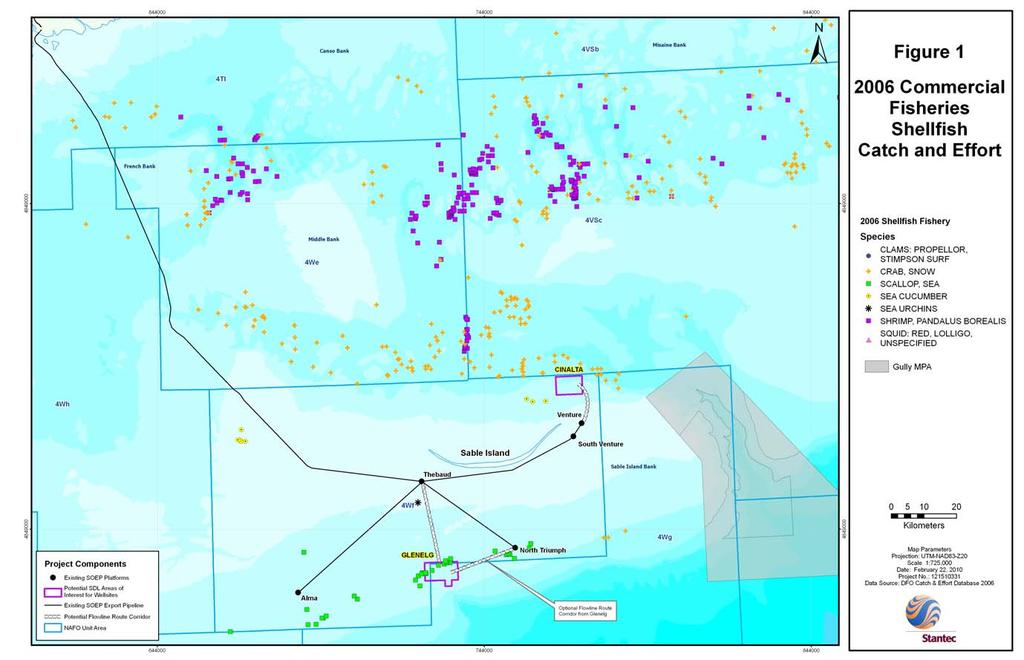
98 93
99 94
100 95
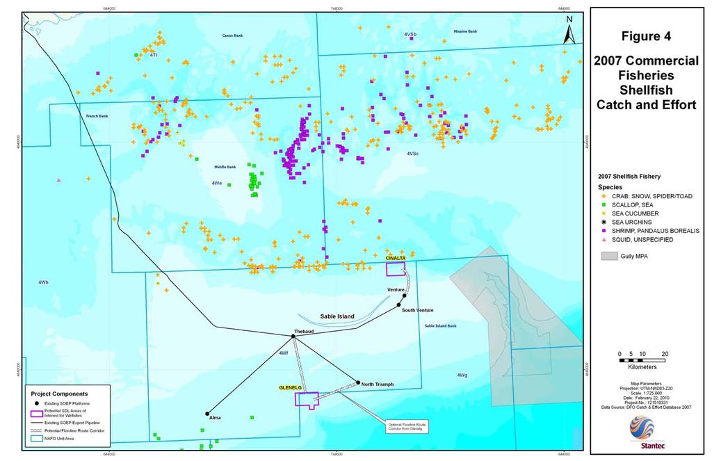
101 96
SEABED SURVEY - POTENTIAL SABLE SUBSEA SATELLITES DEVELOPMENT
 Project Description SEABED SURVEY - POTENTIAL SABLE SUBSEA SATELLITES DEVELOPMENT January 2010 Submitted by: ExxonMobil Canada Properties Prepared by: Hurley Environment Ltd. In association with Stantec
5443 Rainnie Drive Halifax, Nova Scotia B3J 1P8
 Validity of the June 2001 Environmental Impact Assessment of Exploratory Wells in Lower Musquodoboit, Huckleberry and Southampton and the November 2002 Environmental Impact Assessment of Exploratory Wells
Map Showing NAFO Management Units
 Map Showing NAFO Management Units Biology Are 6 species of seals in Atlantic Canadian waters, all of which occur in Newfoundland Two Arctic Species (Ringed, Bearded) Two temperate (Grey, Harbour) Two migratory
TAC Reported Landings * - By-catch only
 DFO Atlantic Fisheries Stock Status Report 96/68E 4Vn 3Ps 4W 4Vs EASTERN SCOTIAN SHELF HADDOCK Background Haddock on the eastern Scotian Shelf and southern Gulf of St. Lawrence are considered as a single
HADDOCK ON THE SOUTHERN SCOTIAN SHELF AND IN THE BAY OF FUNDY (DIV. 4X/5Y)
") Canadian Science Advisory Secretariat Science Advisory Report 26/47 HADDOCK ON THE SOUTHERN SCOTIAN SHELF AND IN THE BAY OF FUNDY (DIV. 4X/5Y) Context Haddock (Melanogrammus aeglefinus) are found on both
Canadian Science Advisory Secretariat Science Advisory Report 26/47 HADDOCK ON THE SOUTHERN SCOTIAN SHELF AND IN THE BAY OF FUNDY (DIV. 4X/5Y) Context Haddock (Melanogrammus aeglefinus) are found on both
Groundfish was purchased during this reporting period (Indicate amounts in table below) Groundfish was not purchased during this reporting period
 Groundfish was not purchased during this reporting period") NOVA SCOTIA FISH BUYERS MONTHLY PURCHASING REPORT IMPORTANT THIS REPORT IS DUE ON THE SECOND FRIDAY FOLLOWING EACH REPORTING MONTH Company/Individual s Name: Licence Number Month Reported Instructions
NOVA SCOTIA FISH BUYERS MONTHLY PURCHASING REPORT IMPORTANT THIS REPORT IS DUE ON THE SECOND FRIDAY FOLLOWING EACH REPORTING MONTH Company/Individual s Name: Licence Number Month Reported Instructions
Strategic Environmental Assessment
 Strategic Environmental Assessment PETROLEUM EXPLORATION ACTIVITIES ON THE SOUTHWESTERN SCOTIAN SLOPE Submitted to: Canada-Nova Scotia Offshore Petroleum Board Prepared by: Hurley Environment Ltd. October,
BEFORE THE ENVIRONMENTAL PROTECTION AUTHORITY JOINT STATEMENT OF EXPERTS IN THE FIELD OF MARINE MAMMALS
 BEFORE THE ENVIRONMENTAL PROTECTION AUTHORITY IN THE MATTER of the Exclusive Economic Zone and Continental Shelf (Environmental Effects) Act 2012 AND IN THE MATTER of an Application for Marine D u m p
Gulf of the Farallones National Marine Sanctuary Safe Harbor for Sea Turtles
 Gulf of the Farallones National Marine Sanctuary Safe Harbor for Sea Turtles Photos by Doug Perrine They re here now! Leatherbacks swim 6,000 miles from Indonesia to California to Feed on Jellyfish ~ August
The Protection of Vulnerable Marine Ecosystems in the Northwest Atlantic: NAFO Processes and Regulations
 The Protection of Vulnerable Marine Ecosystems in the Northwest Atlantic: NAFO Processes and Regulations Dr. Ricardo Federizon Senior Fisheries Commission Coordinator Northwest Atlantic Fisheries Organization
NEWFOUNDLAND REGION GROUNDFISH OVERVIEW
 DFO Science Stock Status Report A2-19 (1998) NEWFOUNDLAND REGION GROUNDFISH OVERVIEW Background In Newfoundland, Science Branch of the Department of Fisheries and Oceans is responsible, either directly
RE: Stakeholder Comments for St Lawrence Snow Crab Trap Fishery and Scotian Shelf Snow Crab Trap Fishery Re-Certifications PCDRs
 Jean Ragg Programme Administrator SAI GLOBAL Email: jean.ragg@saiglobal.com July 6, 2017 RE: Stakeholder Comments for St Lawrence Snow Crab Trap Fishery and Scotian Shelf Snow Crab Trap Fishery Re-Certifications
Marine Mammals. James M. Price. Division of Environmental Sciences. from NOAA photograph library
 Marine Mammals from NOAA photograph library James M. Price James.Price@boem.gov Division of Environmental Sciences Environmental Studies Program R/V Pisces (from NOAA Web site) Develops and oversees applied
Eastern Shore Islands Area of Interest Community Newsletter
 Eastern Shore Islands Area of Interest Community Newsletter Fall 2018 1ỊNTRODUCTION In addition to information on our Fisheries and Oceans Canada (DFO) website, we have now created a seasonal, community
National Report on Large Whale Entanglements
 National Report on Large Whale Entanglements Confirmed in the United States in 2017 In 2017, 76 confirmed cases of large whale entanglements were documented along the coasts of the United States. Seventy
Sound production in mysticetes. Background. Cetacean vocal frequency ranges Dolphins
 Sound production in mysticetes Fish 475 - May 4 2007 Background Cetaceans produce sound in the widest range of frequencies for any Class of animal Subsonic to supersonic and everywhere in between Sound
Eastern Tuna and Billfish Fishery Sea Turtle Mitigation Plan (TMP)
") SCIENTIFIC COMMITTEE FIFTH REGULAR SESSION 10-21 August 2009 Port Vila, Vanuatu Eastern Tuna and Billfish Fishery Sea Turtle Mitigation Plan (TMP) WCPFC-SC5-2009/EB-IP-15 Australian Government Department
SCIENTIFIC COMMITTEE FIFTH REGULAR SESSION 10-21 August 2009 Port Vila, Vanuatu Eastern Tuna and Billfish Fishery Sea Turtle Mitigation Plan (TMP) WCPFC-SC5-2009/EB-IP-15 Australian Government Department
I. Monitoring and Adaptive Management Approach. Potential Effects, Monitoring Studies & Mitigation
 I. Monitoring and Adaptive Management Approach Define the problem or management objective. Determine potential effects of the project on indicator species. Emphasis on examining potentially negative, rather
Listed species under the jurisdiction of NOAA Fisheries that occur in the geographic area of responsibility of the Wilmington District are:
 Information to assist in compliance with Nationwide Permit General Condition 18, Endangered Species Required Reporting via Pre-Construction Notification The purpose of this document is to provide information
Essential Fish Habitat
 Pacific Fishery Management Council Fact sheet: Essential Fish Habitat Habitat is the environment where an animal lives, feeds, and reproduces. Identifying fish habitat is complex because fish move through
Essential Fish Habitat OCNMS Advisory Council July 13, 2013
 Essential Fish Habitat OCNMS Advisory Council July 13, 2013 John Stadler Habitat Conservation Division NMFS Northwest Region Essential Fish Habitat (EFH) What is it, where did it come from, and what does
AGENCY: National Marine Fisheries Service (NMFS), National Oceanic and Atmospheric
, National Oceanic and Atmospheric") This document is scheduled to be published in the Federal Register on 05/30/2013 and available online at http://federalregister.gov/a/2013-12869, and on FDsys.gov BILLING CODE 3510-22-P DEPARTMENT OF COMMERCE
This document is scheduled to be published in the Federal Register on 05/30/2013 and available online at http://federalregister.gov/a/2013-12869, and on FDsys.gov BILLING CODE 3510-22-P DEPARTMENT OF COMMERCE
SCIENTIFIC COUNCIL MEETING - JUNE Polish Research Report, by A. J. Paciorkowski Sea Fisheries Institute Gdynia Poland.
 NOT TO BE CITED WITHOUT PRIOR REFERENCE TO THE,SECRETARIAT Northwest Atlantic Fisheries Organization Serial No. N17 NAFO SCS Doc. 80/VI/ SCIENTIFIC COUNCIL MEETING JUNE 1980 Polish Research Report, 1979
2012 Environmental Assessment Review Hibernia Drill Centres Construction and Operations Review
 Stantec Consulting Ltd. 607 Torbay Road St. John s, NL A1A 4Y6 Tel: (709) 576-1458 Fax: (709) 576-2126 2012 Environmental Assessment Review Hibernia Drill Centres Construction and Operations Review Prepared
CMM Conservation and Management Measure for the Management of Bottom Fishing in the SPRFMO Convention Area
 CMM 03-2018 1 Conservation and Management Measure for the Management of Bottom Fishing in the SPRFMO Convention Area The Commission of the South Pacific Regional Fisheries Management Organisation; RECOGNISING
canada s in-depth guide to Sustainable Seafood .org SeaChoice is a sustainable seafood program of the following four conservation groups:
 canada s in-depth guide to Sustainable Seafood.org SeaChoice is a sustainable seafood program of the following four conservation groups: www.seachoice.org SeaChoice is a national program that helps Canadian
Main resolutions and recommendations relating to straddling species adopted by regional fisheries management organizations and implemented by Mexico
 Main resolutions and recommendations relating to straddling species adopted by regional fisheries management organizations and implemented by Mexico International Commission for the Conservation of Atlantic
SEISMIC EXPLORATION POTENTIAL IMPACTS ON FINFISH AND INVERTEBRATE SPECIES
 SEISMIC EXPLORATION POTENTIAL IMPACTS ON FINFISH AND INVERTEBRATE SPECIES The amount of marine seismic shot in British Columbia waters during the last 40 years has been minimal compared to that in Eastern
ASSESSMENT OF THE WEST COAST OF NEWFOUNDLAND (DIVISION 4R) HERRING STOCKS IN 2011
 HERRING STOCKS IN 2011") Canadian Science Advisory Secretariat Science Advisory Report 212/24 ASSESSMENT OF THE WEST COAST OF NEWFOUNDLAND (DIVISION 4R) HERRING STOCKS IN 211 Context Figure 1. Map of unit areas of NAFO Division
Canadian Science Advisory Secretariat Science Advisory Report 212/24 ASSESSMENT OF THE WEST COAST OF NEWFOUNDLAND (DIVISION 4R) HERRING STOCKS IN 211 Context Figure 1. Map of unit areas of NAFO Division
Fisheries and Oceans Canada (DFO) Update on North Atlantic Right Whale Recovery Planning and Management Activities
 Update on North Atlantic Right Whale Recovery Planning and Management Activities") Fisheries and Oceans Canada (DFO) Update on North Atlantic Right Whale Recovery Planning and Management Activities Merriman, C. 1 1 Fisheries and Oceans Canada, Bedford Institute of Oceanography, 1 Challenger
Fisheries and Oceans Canada (DFO) Update on North Atlantic Right Whale Recovery Planning and Management Activities Merriman, C. 1 1 Fisheries and Oceans Canada, Bedford Institute of Oceanography, 1 Challenger
MANAGEMENT OF KRILL AS AN ESSENTIAL COMPONENT OF THE CALIFORNIA CURRENT ECOSYSTEM
 MANAGEMENT OF KRILL AS AN ESSENTIAL COMPONENT OF THE CALIFORNIA CURRENT ECOSYSTEM AMENDMENT 12 TO THE COASTAL PELAGIC SPECIES FISHERY MANAGEMENT PLAN ENVIRONMENTAL ASSESSMENT, REGULATORY IMPACT REVIEW
Fine-Scale Survey of Right and Humpback Whale Prey Abundance and Distribution
 DISTRIBUTION STATEMENT A. Approved for public release; distribution is unlimited. Fine-Scale Survey of Right and Humpback Whale Prey Abundance and Distribution Joseph D. Warren School of Marine and Atmospheric
Warmer temperatures, molt timing and lobster seasons in the Canadian Maritimes
 Warmer temperatures, molt timing and lobster seasons in the Canadian Maritimes John Tremblay 1, Jean Lavallee 2 and Ross Claytor 1 1 Population Ecology Division, Fisheries and Oceans, Bedford Institute
Marine Mammals in Faroese Waters
 Marine Mammals in Faroese Waters With Special Attention to the South-south-eastern Sector of the Region by Dorete Bloch 1, Bjarni Mikkelsen 2 and Lise H. Ofstad 2 1 Museum of Natural History 2 Faroese
Project Context. Legend. Jacky. Project Boundary. Fixed Platform/Structure Existing Demonstrator Turbine. Scottish Territorial Waters Boundary
 3 0'0"W Legend C A Jacky B Project Boundary Fixed Platform/Structure Existing Demonstrator Turbine Scottish Territorial Waters Boundary 58 0'0"N British Crown and SeaZone Solutions Limited. All rights
SC WG ON THE ECOSYSTEM APPROACH TO FISHERIES MANAGEMENT MAY 2008
 NOT TO BE CITED WITHOUT PRIOR REFERENCE TO THE AUTHOR(S) Northwest Atlantic Fisheries Organization Serial No. N5612 NAFO SCR Doc. 08/79 SC WG ON THE ECOSYSTEM APPROACH TO FISHERIES MANAGEMENT MAY 2008
Prepared by Australia
 SIXTH REGULAR SESSION Papeete, Tahiti, French Polynesia 7-11 December 2009 AUSTRALIA REVISED DRAFT EASTERN TUNA AND BILLFISH FISHERY SEA TURTLE MITIGATION PLAN (TMP) WCPFC6-2009/IP16 16 th November 2009
Analyzing Human- Environment Interactions using GIS. Cape Breton Highlands Education Centre/Academy
 Analyzing Human- Environment Interactions using GIS Cape Breton Highlands Education Centre/Academy Global Geography 12 The Right Whale Project Why are Right Whales Dying in the Gulf of St. Lawrence?
Serial No. N4859 NAFO SCR Doc. 03/41 SCIENTIFIC COUNCIL MEETING JUNE 2003
 NOT TO BE CITED WITHOUT PRIOR REFERENCE TO THE AUTHOR(S) Northwest Atlantic Fisheries Organization Serial No. N4859 NAFO SCR Doc. 03/41 SCIENTIFIC COUNCIL MEETING JUNE 2003 Results of a Greenland Halibut
Southern Gulf of St. Lawrence Sea Scallop
 DFO Science Stock Status Report C3-16 (1998) 21 22 23 24 Southern Gulf of St. Lawrence Sea Scallop Background The sea scallop (Placopecten magellanicus), is a bivalve mollusc found only in the north-western
A-7 End of Survey Environmental Report Marine Seismic Survey
 A-7 End of Survey Environmental Report Marine Seismic Survey Table of Contents 1. INTRODUCTION... 3 1.1 Purpose... 3 2. ACTIVITY SUMMARY... 3 3. THAZIN MSS MFO MITIGATION SUMMARY... 4 3.1 Summary information...
Information To Assist In Compliance With Nationwide Permit General Condition 18, Endangered Species
 Information To Assist In Compliance With Nationwide Permit General Condition 18, Endangered Species This document implements one of the protective measures identified in the November 24, 2014 programmatic
Evolution of Deepwater Coral Protection in the Southeast U.S
 Evolution of Deepwater Coral Protection in the Southeast U.S Tina Udouj, Florida Fish and Wildlife Conservation Commission Roger Pugliese, South Atlantic Fishery Management Council Overview Deepwater Corals
NOTICES TO MARINERS 1 to 46 ANNUAL EDITION 2018
 NOTICES TO MARINERS 1 to 46 CANADIAN COAST GUARD www.notmar.gc.ca Notices to Mariners 1 to 46 Annual Edition 2018 Published under the authority of: Canadian Coast Guard Programs Aids to Navigation and
Eastern and South Shore Nova Scotia Lobster LFAs The Fishery. DFO Atlantic Fisheries Stock Status Report 96/117E.
 Maritimes Region DFO Atlantic Fisheries Stock Status Report 96/117E Eastern and South Shore Nova Scotia Lobster LFAs 31-33 Background Lobsters first entering the fishery in LFAs 31, 32, and 33 are probably
2016 West Coast Entanglement Summary
 March 2017 2016 West Coast Entanglement Summary Overview of Entanglement Data west coast region MMHSRP Permit #18786 In 2016, 71 separate cases of entangled whales were reported off the coasts of Washington,
Framework 35 Northeast Multispecies FMP
 and 2. In addition to small mesh multispecies, vessels target herring in Small Mesh Areas 1 and 2 and therefore use mesh smaller than 2.5-inches in the codend. The net specifications listed in Section
While oil and gas is the nations largest export product in value, fish is the second largest. Both activities are crucial for the Norwegian economy.
 Oil and fish in Norwegian waters conflict or coexistence? Kristoffersen Arne, Norwegian Coastal Fishermen Union representative, Norway 1. Presentation: Arne Helge Kristoffersen: Representative from the
Implementing the New Fisheries Protection Provisions under the Fisheries Act
 Implementing the New Fisheries Protection Provisions under the Fisheries Act Discussion Paper Fisheries and Oceans Canada April 2013 Contents 1. Introduction 2. Managing Threats to Canada s Fisheries 3.
Introduction. Biological Profile
 Introduction Porcupine Crab (Neolithodes grimaldii) inhabits the sea bed off the Coast of Newfoundland and Labrador in depths beyond 500 fathoms (fm). This large crab is often caught as a by-catch in the
Fisheries of the Caribbean, Gulf of Mexico, and South Atlantic; Reef Fish Fishery of Puerto Rico and the U.S. Virgin Islands;
 This document is scheduled to be published in the Federal Register on 06/11/2018 and available online at https://federalregister.gov/d/2018-12420, and on FDsys.gov BILLING CODE: 3510-22-P DEPARTMENT OF
Spatial/Seasonal overlap between the midwater trawl herring fishery and predator focused user groups
 Spatial/Seasonal overlap between the midwater trawl herring fishery and predator focused user groups A working paper submitted to the Herring PDT Micah Dean July 26, 2017 Introduction A goal of Amendment
Gulf of Maine Research Institute Responsibly Harvested Seafood from the Gulf of Maine Region Report on Atlantic Sea Scallops (Inshore Canada)
") Gulf of Maine Research Institute Responsibly Harvested Seafood from the Gulf of Maine Region Report on Atlantic Sea Scallops (Inshore Canada) The fishery is managed by a competent authority and has a management
Gulf of Maine Research Institute Responsibly Harvested Seafood from the Gulf of Maine Region Report on Atlantic Sea Scallops (Inshore Canada) The fishery is managed by a competent authority and has a management
NOAA FISHERIES SERVICE. Habitat Assessment Prioritization
 NOAA FISHERIES SERVICE Habitat Assessment Prioritization What is a Habitat Assessment? A habitat assessment is both the process and products associated with consolidating, analyzing, and reporting the
Consultation Workbook
 Species at Risk Act (SARA) Legal Listing of Aquatic Species For the Harbour Porpoise, Phocoena phocoena, Northwest Atlantic population, in eastern Canadian waters SARA Legal Listing of Aquatic Species
Summary of Research within Lamlash Bay No-Take Zone - Science report for COAST July
 Summary of Research within Lamlash Bay No-Take Zone - Science report for COAST July 2013 - *Picture of a spider crab (Macropodia spp) inside a plumose anemone. Taken within Lamlash Bay No-Take Zone by
Prepared by. and. for. Shell Canada Limited
 MARINE MAMMAL AND SEA TURTLE MONITORING, RESULTS FOR THE CHESHIRE L97-A WELL: SHELL CANADA LIMITED S SHELBURNE BASIN VENTURE EXPLORATION DRILLING PROJECT Prepared by and for Shell Canada Limited LGL Report
Chapter 15 : Fisheries and Aquaculture
 Chapter 15 : Fisheries and Aquaculture identify the importance of marine ecosystems to Newfoundland and Labrador. Include: Note - oceans and greenhouse gas control : oceans surface (photic zone) abundant
Risk Assessments in the Pacific Fisheries for BC & Yukon
 Risk Assessments in the Pacific Fisheries for BC & Yukon MARCH, 2017 CONTENTS Introduction to Risk Assessments... 2 Q&As on the Risk Assessment Process... 3 Overview of the Risk Assessment Tool... 4 Example
SA2 + Div. 3K Redfish
 Fisheries and Oceans Pêches et Océans Canada Canada DFO Science Stock Status Report A2-15(21) entered the fishery in 1975 and averaged about 16,5 t from 1978-1986. The steady reduction in catches from
Arctic Fisheries: Present and future perspectives
 Challenges of the Changing Arctic: Continental Shelf, Navigation and Fisheries Arctic Fisheries: Present and future perspectives Harald Loeng Outline of the talk Some basic background what do we know Climate
2017 MONTHLY FISH BUYERS PURCHASING REPORT
 2017 MONTHLY FISH BUYERS PURCHASING REPORT IMPORTANT: This report is due on or before the second Friday of the month following the reporting period. LICENSEE NAME BUYER LICENCE NUMBER REPORTING MONTH Instructions:
2017 CONSERVATION HARVESTING PLAN Atlantic Halibut (4RST) Prince Edward Island fixed gear fleet Less than meters
 Prince Edward Island fixed gear fleet Less than meters") Approved on July 13, 2017 APPLICATION This Conservation Harvesting Plan (CHP) applies to all Prince Edward Island (PEI) fixed gear licence holders fishing Atlantic halibut in NAFO Divisions 4RST with vessels
Approved on July 13, 2017 APPLICATION This Conservation Harvesting Plan (CHP) applies to all Prince Edward Island (PEI) fixed gear licence holders fishing Atlantic halibut in NAFO Divisions 4RST with vessels
Essential Fish Habitat Consultation
 1 Essential Fish Habitat Consultation Marine Shoreline Development Workshop February 21, 2007 John H. Stadler Washington State Habitat Office National Marine Fisheries Service Magnuson-Stevens Fishery
/ Advice May 2011
 1.5.1.3/1.5.4.1 Advice May 2011 ECOREGION SUBJECT General advice Update of cold-water coral and sponge maps and the information underpinning such maps on Vulnerable Marine Habitats (including Hatton and
INTRODUCTION SEAS AND OCEANS: A PRECIOUS RESOURCE KEY FACTS
 6 ~ SEAS FOR LIFE INTRODUCTION SEAS AND OCEANS: A PRECIOUS RESOURCE We all benefit from our seas and oceans. In addition to the more traditional uses like transport, fishing, aquaculture, tourism and recreation,
Socioeconomic Profile and Spatial Analysis of Fisheries in the three central California National Marine Sanctuaries
 Socioeconomic Profile and Spatial Analysis of Fisheries in the three central California National Marine Sanctuaries Overview and Assessment of CDFG Fisheries Data for use in the Joint Management Plan Review
Comparison of EU and US Fishery management Systems Ernesto Penas Principal Adviser DG Mare
 Comparison of EU and US Fishery management Systems Ernesto Penas Principal Adviser DG Mare Stock and Fisheries Status Seminar Brussels, 26 September 2017 Why comparing the EU and the US? Need to put the
HOW CAN WE HELP TO SUSTAIN AQUATIC BIODIVERSITY?
 HOW CAN WE HELP TO SUSTAIN AQUATIC BIODIVERSITY? Marine Biodiversity The most marine biodiversity is found: 1. Coral reefs 2. Estuaries 3. Deep-ocean floor Biodiversity is higher near coasts than in the
COUNTRIES THAT CONTRAVENED SCIENTIFIC ADVICE BY HARVESTING MIXED POPULATIONS OF NORTH AMERICAN SALMON IN 2017
 SCIENTIFIC ADVICE The International Council for the Exploration of the Sea (ICES) advises: There is no surplus of multi-sea-winter salmon for a fishery at West Greenland for 2018, 2019, and 2020. ICES
Nordatlantisk Fiskeriministerkonference i Shediac 29. august 2017
 Naalakkersuisoq Karl-Kristian Kruses tale Nordatlantisk Fiskeriministerkonference i Shediac 29. august 2017 Dear friends and colleagues I would like to thank our hosts for this chance to visit beautiful
To Fish or Not to Fish? A role-playing activity based on the Marine Reserves process at the Channel Islands National Marine Sanctuary
 To Fish or Not to Fish? A role-playing activity based on the Marine Reserves process at the Channel Islands National Marine Sanctuary Introduction This role playing activity is designed to teach you about
Haddock, Iceland, ICES Va, Danish Seine
 Haddock, Iceland, ICES Va, Danish Seine Haddock, Iceland, ICES Va, Danish Seine Content last updated 2nd Aug 2017 Stock: Haddock in the Iceland grounds (ICES Division Va) Management: Iceland Overview Haddock
SOMALIA National Report to the Scientific Committee of the Indian Ocean Tuna Commission, 2015
 SOMALIA National Report to the Scientific Committee of the Indian Ocean Tuna Commission, 2015 Authors Ministry of Fisheries & Marine Resources Federal Republic of Somalia INFORMATION ON FISHERIES, RESEARCH
Essential Fish Habitat
 Backgrounder: Essential Fish Habitat This fact sheet answers the following questions: What is essential fish habitat (EFH)? What is the Habitat Committee? Do I need to do an EFH consultation for my project?
no-take zone 1 of 5 Channel Islands National Marine Sanctuary, California
 This website would like to remind you: Your browser (Apple Safari 4) is out of date. Update your browser for more security, comfort and the best experience on this site. Encyclopedic Entry no-take zone
ATLANTIC STURGEON. Consultations on listing under the Species at Risk Act
 ATLANTIC STURGEON Consultations on listing under the Species at Risk Act Information summary and questionnaire for consultations on adding two Atlantic Sturgeon populations to the List of Wildlife Species
Atlantic cod, No rthern stock in Newfoundland and Labrador region
 Atlantic cod, Northern stock in Newfoundland and Labrador region, Longlines Content last updated 31st Jul 2017 Stock: Northern cod in NAFO Divisions 2J3KL (Newfoundland and Labrador region) Management:
7TH ANNUAL MEETING OF THE COMMISSION
 7TH ANNUAL MEETING OF THE COMMISSION 23-27 January 2019, The Hague, The Netherlands COMM7-Prop15.1 Background document: A Proposal for a research fishing Conservation and Management Measure for SPRFMO
Petroleum Exploration Licence 39 Exploration Programme. Executive Summary. Delivering sustainable solutions in a more competitive world
 Petroleum Exploration Licence 39 Exploration Programme Environmental Impact Assessment Report Update Executive Summary August 2014 www.erm.com Delivering sustainable solutions in a more competitive world
Focus on New Sites for Caves and Reefs Issues Identified. Dr. Leyla Knittweis-Mifsud Department of Biology, Faculty of Science University of Malta
 Focus on New Sites for Caves and Reefs Issues Identified Dr. Leyla Knittweis-Mifsud Department of Biology, Faculty of Science University of Malta Presentation Overview Areas of conservation potential within
Briefing on the IWC s Conservation Committee
 Briefing on the IWC s Conservation Committee 1 June 2005 Taking the IWC Conservation Committee forward At its 55 th Annual Meeting in 2003, the International Whaling Commission voted to establish a Conservation
Bay of Fundy Estuary Profile
 s The is a sub-basin of the Bay of Fundy along the northwestern shore of Nova Scotia and at the western end of the Annapolis Valley. The Annapolis River is the major water source flowing into the estuary.
CMM Conservation and Management Measure for the Management of New and Exploratory Fisheries in the SPRFMO Convention Area.
 CMM 13-2016 1 Conservation and Management Measure for the Management of New and Exploratory Fisheries in the SPRFMO Convention Area. The Commission of the South Pacific Regional Fisheries Management Organisation;
Channel Manche, refuge for the migratory fish? Dylan Roberts SAMARCH Project Manager
 Channel Manche, refuge for the migratory fish? Dylan Roberts SAMARCH Project Manager The Game and Wildlife Conservation Trust Welcome to the SAMARCH project www.samarch.org The Game and Wildlife Conservation
Fin Whale. Appendix A: Marine Wildlife. Balaenoptera physalus. New Hampshire Wildlife Action Plan Appendix A Marine-38. Federal Listing.
 Fin Whale Balaenoptera physalus Federal Listing State Listing Global Rank Rank Regional Status E not tracked G3G4TNR State Very High Photo by Christin Khan, NOAA/NEFSC Justification (Reason for Concern
The Shelburne Basin Venture Exploration Drilling Project: Environmental Review of Riser/Lower Marine Riser Package Response Options
 The Shelburne Basin Venture Exploration Drilling Project: Environmental Review of Riser/Lower Marine Riser Package Response Options Prepared for: Shell Canada Limited Prepared by: Stantec Consulting Ltd.
Implementing the New Fisheries Protection Provisions under the Fisheries Act
 Implementing the New Fisheries Protection Provisions under the Fisheries Act Part 1 Legislation and Policy * The information in this presentation represents concepts as they have been developed to this
Atlantic Sturgeon Update NER Protected Resources
 Atlantic Sturgeon Update NER Protected Resources June 18, 2013 Outline Brief background Update on information available for Atlantic sturgeon Overview of draft batched fisheries Biological Opinion (BiOp)
GUIDE to FISH & FISHING on the NORTH YORK MOORS COAST
 GUIDE to FISH & FISHING on the NORTH YORK MOORS COAST HISTORY Fishing has always played an important part in North Yorkshire s maritime heritage. The industry still plays a significant role in everyday
Prepared by. and. for. Shell Canada Limited
 MARINE MAMMAL AND SEA TURTLE MONITORING RESULTS FOR THE MONTEREY JACK E-43A WELL, SHELL CANADA LIMITED S SHELBURNE BASIN VENTURE EXPLORATION DRILLING PROJECT Prepared by and for Shell Canada Limited LGL
CALIFORNIA DEPARTMENT OF FISH AND WILDLIFE REPORT ON SWORDFISH MANAGEMENT AND MONITORING PLAN
 Agenda Item G.2.a Supplemental CDFW Report September 2015 CALIFORNIA DEPARTMENT OF FISH AND WILDLIFE REPORT ON SWORDFISH MANAGEMENT AND MONITORING PLAN At this meeting the Pacific Fishery Management Council
Winter Skate. Leucoraja ocellata Kesikewey Kekunaluej
 Winter Skate Leucoraja ocellata Kesikewey Kekunaluej Description Skates are a disc shaped fish, related to the shark family. Skates are very flat and it is hard to tell what is body and what is fin. Their
COMPLETION REPORT Component 2
 REDNET - A Network to Redevelop a Sustainable Redfish (Sebastes fasciatus) Trawl Fishery in the Gulf of Maine COMPLETION REPORT Component 2 16 April 212 Written by Kohl Kanwit, Mike Pol and Pingguo He
U.S. Marine Mammal Protection Act Import Provisions:
 U.S. Marine Mammal Protection Act Import Provisions: Office of International Affairs and Seafood Inspection Program The Regulation, the List of Foreign Fisheries, and a Regional Analysis of Marine Mammal
Reducing Risk of Whale Entanglements in Oregon Dungeness Crab Gear
 Session 3 Reducing Risk of Whale Entanglements in Oregon Dungeness Crab Gear CaseID: 20150703Mn NMFS MMHSRP Permit #: 18786 Overview West Coast Information Framing the problem Summary of West Coast large
SENATE BILL No Agenda Item H.1 Supplemental Attachment 3 April 2018 AMENDED IN SENATE MARCH 21, Introduced by Senator Allen
 AMENDED IN SENATE MARCH 21, 2018 Agenda Item H.1 Supplemental Attachment 3 April 2018 SENATE BILL No. 1017 Introduced by Senator Allen February 7, 2018 An act to amend Sections 8394.5, 8567, and 8579 of,
Northeast Atlantic Mackerel, Handlines
 Northeast Atlantic Mackerel, Handlines Northeast Atlantic Mackerel, Handlines Content last updated 3rd Apr 2017 Stock: Mackerel (Scomber scombrus) in subareas 1 7 and 14, and in divisions 8.a e and 9.a
The Science of Rebuilding Fisheries: State of Play and Current issues
 The Science of Rebuilding Fisheries: State of Play and Current issues Steve Murawski Director of Scientific Programs and Chief Science Advisor U.S. National Marine Fisheries Service OECD Workshop: Economics
Review of the Changes to the Fisheries Act
 Review of the Changes to the Fisheries Act Fisheries Protection Program Maritimes Region Presentation to Environmental Services Association Maritimes November 2, 2016 Presentation Overview Background Fisheries