MIDDLE FORK RESERVOIR Wayne County 2006 Fish Management Report. Christopher C. Long Assistant Fisheries Biologist
|
|
|
- Florence McCoy
- 6 years ago
- Views:
Transcription

1 MIDDLE FORK RESERVOIR Wayne County 2006 Fish Management Report Christopher C. Long Assistant Fisheries Biologist Fisheries Section Indiana Department of Natural Resources Division of Fish and Wildlife I.G.C.-South, Room W W. Washington Street Indianapolis, Indiana
2 EXECUTIVE SUMMARY Middle Fork Reservoir is a 177-acre water supply impoundment located in Richmond, Indiana. A fishery survey was conducted May 30 to June 1, 2006 to evaluate the predator/prey balance, determine the age of dominant sportfish, and evaluate recruitment of largemouth bass, bluegill, and white crappie. A total of 1,650 fish representing 13 species and hybrid sunfish was collected with an estimated weight of 781 lbs. The three most abundant species collected by number were white crappie (952), bluegill (333), and largemouth bass (150). The three most abundant species collected by weight were common carp (180 lbs), white crappie (178 lbs), and white sucker (156 lbs). White crappie ranged in length from 4.6 to 10.2 in and averaged 7.6 in. Approximately 64% of the white crappie were 7.5 to 8.0 in long. Age-4 and age-5 crappie made up 27 and 46% of the sample, respectively. Bluegill ranged in length from 2.1 to 8.6 in and averaged 5.7 in. Forty-three percent of the bluegill collected were harvestable size (> 6 in). Largemouth bass ranged in length from 3.8 to 18.9 in and averaged 11.1 in. Seventeen percent of the largemouth bass collected met or exceeded the 14-in minimum length limit. Eighteen channel catfish were collected that ranged in length from 13.5 to 29.0 in. All channel catfish were considered harvestable size. The largest channel catfish weighed approximately 12 lbs. Natural reproduction is evident and therefore supplemental stockings are not recommended. Populations of largemouth bass and bluegill need to be monitored to ensure satisfactory recruitment in response to the abundance of white crappie. The next fisheries survey is scheduled for i
3 INTRODUCTION Middle Fork Reservoir is a 177-acre impoundment located in Richmond, Indiana. The lake was built in the early 1960 s as a water supply reservoir for the city. The Richmond Department of Parks and Recreation leases the lake along with 350 acres of surrounding land. A fee is required to launch a boat or avid visitors can purchase an annual launch permit. There is also a 6 hp maximum limit on outboard motors. Fisheries managers can utilize few management strategies other than fish stockings and fishing regulations since Middle Fork Reservoir is used as a potable water supply. Management options such as drawdowns and the use of fish toxicants are prohibited. Statewide size and creel limits apply for largemouth bass, white crappie, and channel catfish at Middle Fork Reservoir. In both 2000 and 2002, largemouth bass was the most abundant species collected at Middle Fork Reservoir. The expansion of the largemouth bass population led to increased predation on crappie and bluegill. As a result, bluegill and crappie growth and size structure were good. However, by 2004 the white crappie population exploded causing growth of crappie to decline and the recruitment of largemouth bass and bluegill to suffer. The goal of the 2006 fisheries survey at Middle Fork Reservoir was to describe the predator/prey balance, determine the age of the dominant sportfish, and evaluate recruitment of largemouth bass, bluegill, and white crappie. METHODS The survey was conducted from May 30 to June 1, Physical and chemical characteristics were collected for water quality and measured in the deepest area of the lake according to the Division of Fish and Wildlife (DFW) sampling guidelines (Shipman 2001). Submersed aquatic vegetation was sampled on July 18, 2006, using guidelines written by DFW (2006). Fish were collected using three sampling gears. Pulsed DC shoreline electrofishing was conducted at night for 1.0 h with two dippers. Four trap nets and eight experimental-mesh gill nets were also fished overnight. All fish collected were measured to the nearest 0.1 in TL. Average weights for Fish Management District 5, or length-weight regressions were used to estimate the weight of all fish collected. Scales were taken from largemouth bass, bluegill, and white crappie for age and growth analysis. Proportional stock density (PSD) was calculated for 1
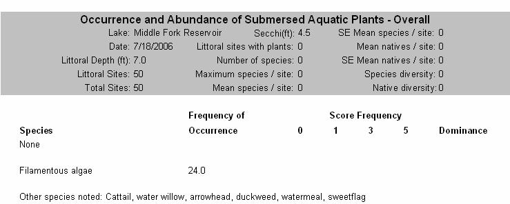
4 largemouth bass and bluegill (Anderson and Neumann 1996). The Bluegill Fishing Potential Index (BGFP), developed by Ball and Tousignant, 1996, was utilized to describe the bluegill fishing opportunities at Middle Fork Reservoir. RESULTS The surface temperature at Middle Fork Reservoir on May 30 was 70.9 ºF and 60.9 ºF at 26 ft. Alkalinity was mg/l at both the surface and 26 ft. Conductivity was 420 µs and the Secchi disk reading was 7.5 ft. No submergent vegetation was collected. Non-submergent vegetation observed included cattails, filamentous algae, water willow, arrowhead, duckweed, watermeal, and sweetflag. Altogether, 1,650 fish representing 13 species and hybrid sunfish were collected with an estimated weight of 781 lbs. The three most abundant species collected by number were white crappie (58%), bluegill (20%), and largemouth bass (9%). The three most abundant species collected by weight were common carp (23%), white crappie (23%), and white sucker (20%). A total of 952 white crappie was collected that weighed 178 lbs. The relative abundance of white crappie was similar between 2004 and 2006 (56 and 58%, respectively). The catch rate (CPUE) of white crappie was 57.6/gill net lift and 35.0/trap net lift. Electrofishing yielded a CPUE of crappie/h. White crappie ranged in length from 4.6 to 10.2 in and averaged 7.6 in compared to 6.8 in in Sixty-four percent of the white crappie collected measured between 7.5 and 8.0 in. Age-1 white crappie made up 1% of the sample. However, 27% of crappie were age 4 and 46% were age 5. The large number of age-4 and age-5 crappie was expected because in 2004, approximately 99% of white crappie were age 2 and age 3 (Long 2006). A total of 333 bluegill that weighed roughly 49 lbs was collected. Bluegill was the second most abundant species collected by number (20%) and the fifth most abundant by weight (6%). Electrofishing yielded a CPUE of bluegill/h. Bluegill ranged in length from 2.1 to 8.6 in and averaged 5.7 in. Forty-three percent of the bluegill collected were greater than 6 in long, which was down from 58% in Bluegill PSD was 44. The BGFP score was 26 which qualifies the bluegill fishery as excellent. The survey revealed that 19% of the bluegill collected were age 1 and 34% were age 2. 2
5 Largemouth bass was third in abundance by number (9%) and fourth by weight (16%). There were 150 largemouth bass weighing 128 lbs collected. Electrofishing yielded a CPUE of bass/h. Largemouth bass ranged in length from 3.8 to 18.9 in and averaged 11.1 in. Only 17% of bass met or exceeded the 14-in minimum length limit compared to 60% just two years ago. Largemouth bass PSD was 64. Nineteen percent of the largemouth bass collected were age 1. Only one age-1 bass was collected in White sucker, a fish commonly found in Indiana streams, accounted for 6% of the sample by number and 20% by weight. The 97 white sucker collected ranged in length from 8.5 to 20.0 in and averaged 15.4 in. Twenty-four common carp that weighed 180 lbs were collected. Carp ranked first in abundance by weight (23%). The largest carp collected measured 34.5 in and weighed nearly 20 lbs. Overall, 18 channel catfish were collected that weighed 45 lbs. Channel catfish ranged in length from 13.5 to 29.0 in. Additionally, 16 black bullheads that weighed 26 lbs were collected. Black bullhead ranged in length from 10.6 to 16.8 in and averaged 14.2 in. Two yellow bullhead and one brown bullhead were also collected and all measured 12.8 in. Other fish collected were golden shiner, green sunfish, golden redhorse, pumpkinseed, and hybrid sunfish. Together these species comprised 3% of the sample by number and 2% by weight. DISCUSSION White crappie has been the most abundant species at Middle Fork Reservoir since 2004 as a result of the large year classes spawned in 2001 and These year classes accounted for 99% of the crappie collected in 2004 and 73% in The relative abundance of white crappie was similar between 2004 and 2006 and therefore it appears that their abundance has leveled off. Excluding age-2 white crappie, which accounted for 19% of the collection, crappie recruitment has declined considerably the past few years. Together, age-1 and age-3 white crappie represented only 7% of the crappie collected. Now that the 2001 and 2002 year classes of white crappie average over 7.5 in, they are more likely to be harvested. Crappie abundance is expected to decline considerably over the next several years since there are fewer young fish in the population to replace those lost to harvest and natural mortality. 3
6 In 2004, the 2001 and 2002 year classes of white crappie impacted the recruitment of largemouth bass and bluegill due to increased competition. Over the past couple of years, competition between crappie, bass, and bluegill has decreased because there are fewer young crappie present. As a result, largemouth bass and bluegill recruitment has improved. In 2006, 19% of largemouth bass and bluegill were age 1 and 53% of bluegill were either age 1 or 2. This is an improvement from 2004 when only one age-1 largemouth bass was collected and less than 10% of bluegill were age 1 and 2. Largemouth bass and bluegill should be able to sustain quality fisheries now that recruitment has improved. The proportion of largemouth bass greater than 14 in declined from 60 to 17% between 2004 and 2006, respectively. In 2000, about 47% of the largemouth bass caught were age 1 (Wisener 2003). By 2004, the 1999 year class was age 5 and likely a large contributor to the 60% of bass that were greater than 14 in. It s likely that the majority of the large 1999 year class of largemouth bass has succumbed to natural and fishing mortality. Improved recruitment and the decline of the 1999 year class both provide reasonable explanations as to why only 17% of bass met or exceeded 14 in in Therefore, anglers are encouraged to practice catch and release of largemouth bass to help sustain their numbers and increase predation on panfish and rough fish (i.e. carp and white sucker). Significant predation by largemouth bass will allow panfish to reach a size more desirable by anglers and keep rough fish from overpopulating. Eighteen channel catfish were collected and all were more than 12 in long. Channel catfish have not been stocked since 1997 but natural reproduction is sustaining the population. Additionally, black bullheads are providing a significant contribution to the catfish fishery. Since successful recruitment of channel catfish and bullhead species is occurring and qualitysized catfish are available to anglers, supplemental stocking of channel catfish is not recommended. The next fisheries survey should be conducted in The survey will focus on the predator/prey balance and how the fishery has responded to the changing white crappie population. 4
7 RECOMMENDATIONS The fishery should be resampled in 2008 to evaluate the predator/prey balance, age, and growth of the dominant sportfish. LITERATURE CITED Anderson, R.O. and R.M. Neumann Length, weight, and associated structural indices. Pages in B.R. Murphy and D.W. Willis, editors. Fisheries Techniques 2 nd edition. American Fisheries Society, Bethesda, Maryland. Ball, R.L. and J.N. Tousignant The development of an objective rating system to assess bluegill fishing in lakes and ponds. Research report. Indiana Department of Natural Resources. Division of Fish and Wildlife. Indianapolis, Indiana. 18 pp. Division of Fish and Wildlife Tier II aquatic vegetation survey protocol. Indiana Department of Natural Resources. Indianapolis, Indiana. 22 pp. Long, C.C Middle Fork Reservoir Fish management report. Indiana Department of Natural Resources, Division of Fish and Wildlife. Indianapolis, Indiana. 17pp. Shipman, S.T Manual of fisheries survey methods. Indiana Department of Natural Resources. Division of Fish and Wildlife. Indianapolis, Indiana. 58 pp. Wisener, J.R Middle Fork Reservoir Fish management report. Indiana Department of Natural Resources, Division of Fish and Wildlife. Indianapolis, Indiana. 16pp. Submitted by: Christopher C. Long, Assistant Fisheries Biologist Date: March 5, 2007 Approved by: J. Rhett Wisener, Fisheries Biologist Date: July 6,
8 LAKE SURVEY REPORT Type of Survey Initial Survey x Re-Survey Lake Name Middle Fork Reservoir Biologist's name Christopher C. Long Quadrangle Name New Paris, Richmond Township Name 14N County Wayne LOCATION Range 1W Nearest Town Richmond Date of survey (Month, day, year) 5/30/06-6/1/2006 Date of approval (Month, day, year) 7/6/2007 Section 21,22,27,28 State owned public access site Surface acres Maximum depth Average depth ft 21.3 ft Location of benchmark T14N, R1W, S21, SW1/4, SW1/4 on Hwy. 27 ACCESSIBILITY Other access site Owned by Richmond Dept. of Parks & Recreation Acre feet 3,770 Water level 971 msl Extreme fluctuations 15 ft INLETS Name Location Origin Middle Fork of East Fork of Whitewater River Northeast side Spartansburg, OH Unnamed tributary North side Name Middle Fork of East Fork of Whitewater River Water level control Five 20-in round, varied level sluice gates and spillway POOL ELEVATION (Feet MSL) TOP OF FLOOD CONTROL POOL TOP OF CONSERVATION POOL Watershed use TOP OF DAM TOP OF MINIMUM POOL STREAMBED Location South end OUTLETS Agricultural, residential, and industrial Development of shoreline Concrete boat ramp, boat docks, handicap accessible fishing piers ACRES Bottom type Boulder x Gravel x Sand x Muck Clay Marl Previous surveys and investigations Fish population studies: 1963 and Management surveys: 1973, 1975, 1982, 1984, 1986, 1988, 1990, 1991, 1992, 1997, 2000, 2002, and Spot-check survey: Largemouth bass population estimate: Bluegill survey:
9 Color ELECTROFISHING TRAP NETS GILL NETS ROTENONE Clear Alkalinity (ppm)* Day hours Number of traps Number of nets Gallons 4 8 ppm SAMPLING EFFORT Night hours Number of Lifts Number of Lifts Acre Feet Treated PHYSICAL AND CHEMICAL CHARACTERISTICS Turbidity ph Total hours Total effort 1 4 lifts Total effort 1 8 lifts SHORELINE Number of 100 Foot Seine Hauls SEINING 7 Feet 6 Inches (SECCHI DISK) Surface: Bottom: Surface: Bottom: Conductivity: Air temperature: F 420 microsiemens Water chemistry GPS coordinates: N W TEMPERATURE AND DISSOLVED OXYGEN (D.O.) DEPTH (FEET) Degrees ( F) D.O. (ppm) DEPTH (FEET) DEGREES ( F) D.O. (ppm) DEPTH (FEET) DEGREES ( F) D.O. (ppm) SURFACE COMMENTS *ppm-parts per million 7
10 8
11 SPECIES AND RELATIVE ABUNDANCE OF FISHES COLLECTED BY NUMBER AND WEIGHT LENGTH RANGE WEIGHT *COMMON NAME OF FISH NUMBER PERCENT (inches) (pounds) PERCENT White crappie Bluegill Largemouth bass White sucker Golden shiner Common carp Channel catfish Black bullhead Green sunfish Golden redhorse Pumpkinseed Yellow bullhead Brown bullhead Hybird sunfish < 0.1 Total 1, *Common names of fishes recognized by the American Fisheries Society. 9
12 TOTAL PERCENT AVERAGE TOTAL PERCENT AVERAGE LENGTH NUMBER OF FISH WEIGHT AGE OF LENGTH NUMBER OF FISH WEIGHT AGE OF (inches) COLLECTED COLLECTED (pounds) FISH (inches) COLLECTED COLLECTED (pounds) FISH , , , 4, , 5 TOTAL not aged not aged ELECTROFISHING NUMBER, PERCENTAGE, WEIGHT, AND AGE OF White crappie 351.0/hr GILL NET 57.6/lift TRAP NET 35.0/lift 10
13 TOTAL PERCENT AVERAGE TOTAL PERCENT AVERAGE LENGTH NUMBER OF FISH WEIGHT AGE OF LENGTH NUMBER OF FISH WEIGHT AGE OF (inches) COLLECTED COLLECTED (pounds) FISH (inches) COLLECTED COLLECTED (pounds) FISH , , , , 3, , , , , TOTAL ELECTROFISHING NUMBER, PERCENTAGE, WEIGHT, AND AGE OF Bluegill 276.0/hr GILL NET 2.3/lift TRAP NET 9.8/lift 11
14 NUMBER, PERCENTAGE, WEIGHT, AND AGE OF Largemouth bass TOTAL PERCENT AVERAGE TOTAL PERCENT AVERAGE LENGTH NUMBER OF FISH WEIGHT AGE OF LENGTH NUMBER OF FISH WEIGHT AGE OF (inches) COLLECTED COLLECTED (pounds) FISH (inches) COLLECTED COLLECTED (pounds) FISH , TOTAL , , , , , , , , not aged not aged , 5, not aged not aged ELECTROFISHING 150.0/hr GILL NET 0/lift TRAP NET 0/lift 12
15 TOTAL PERCENT AVERAGE TOTAL PERCENT AVERAGE LENGTH NUMBER OF FISH WEIGHT AGE OF LENGTH NUMBER OF FISH WEIGHT AGE OF (inches) COLLECTED COLLECTED (pounds) FISH (inches) COLLECTED COLLECTED (pounds) FISH not aged TOTAL ELECTROFISHING NUMBER, PERCENTAGE, WEIGHT, AND AGE OF White sucker 0/hr GILL NET /lift TRAP NET 1.8/lift 13
16 TOTAL PERCENT AVERAGE TOTAL PERCENT AVERAGE LENGTH NUMBER OF FISH WEIGHT AGE OF LENGTH NUMBER OF FISH WEIGHT AGE OF (inches) COLLECTED COLLECTED (pounds) FISH (inches) COLLECTED COLLECTED (pounds) FISH TOTAL NUMBER, PERCENTAGE, WEIGHT, AND AGE OF Common carp not aged ELECTROFISHING 17.0/hr GILL NET 0/lift TRAP NET 1.8/lift 14
17 TOTAL PERCENT AVERAGE TOTAL PERCENT AVERAGE LENGTH NUMBER OF FISH WEIGHT AGE OF LENGTH NUMBER OF FISH WEIGHT AGE OF (inches) COLLECTED COLLECTED (pounds) FISH (inches) COLLECTED COLLECTED (pounds) FISH TOTAL not aged NUMBER, PERCENTAGE, WEIGHT, AND AGE OF Channel catfish ELECTROFISHING 3.0/hr GILL NET 1.9/lift TRAP NET 0/lift 15
18 TOTAL PERCENT AVERAGE TOTAL PERCENT AVERAGE LENGTH NUMBER OF FISH WEIGHT AGE OF LENGTH NUMBER OF FISH WEIGHT AGE OF (inches) COLLECTED COLLECTED (pounds) FISH (inches) COLLECTED COLLECTED (pounds) FISH TOTAL not aged ELECTROFISHING NUMBER, PERCENTAGE, WEIGHT, AND AGE OF Black bullhead 6.0/hr GILL NET 0.1/lift TRAP NET 2.3/lift 16
19 White crappie age-length Key Length Total # Sub- Age group (in) number sample Total Bluegill age-length Key Length Total # Sub- Age group (in) number sample Total
20 Largemouth bass age-length Key Length Total # Sub- Age group (in) number sample Total
21 Mean length at Capture White crappie Age Number Mean TL Var SE Lo 95%CI Up 95%CI Bluegill Age Number Mean TL Var SE Lo 95%CI Up 95%CI Largemouth bass Age Number Mean TL Var SE Lo 95%CI Up 95%CI
22 Species YEAR NUMBER OF SIZE BACK CALCULATED LENGTH (inches) AT EACH AGE White crappie CLASS FISH AGED RANGE I II III IV V VI VII VIII Intercept = Species YEAR NUMBER OF SIZE BACK CALCULATED LENGTH (inches) AT EACH AGE Bluegill CLASS FISH AGED RANGE I II III IV V VI VII VIII Intercept = Species YEAR NUMBER OF SIZE BACK CALCULATED LENGTH (inches) AT EACH AGE Largemouth bass CLASS FISH AGED RANGE I II III IV V VI VII VIII Intercept =
23 GPS LOCATION OF SAMPLING EQUIPMENT GILL NETS TRAP NETS ELECTROFISHING N W N W N W N W 2 N W N W N W N W N W N W 4 N W N W N W N W N W N W 6 N W N W N W N W 8 N W N W 10 N W N W 12 N W N W 14 N W N W 16 N W 17 9 N W 18 N W N W
MIDDLE FORK RESERVOIR Wayne County 2004 Fish Management Report. Christopher C. Long Assistant Fisheries Biologist
 MIDDLE FORK RESERVOIR Wayne County 2004 Fish Management Report Christopher C. Long Assistant Fisheries Biologist FISHERIES SECTION INDIANA DEPARTMENT OF NATURAL RESOURCES DIVISION OF FISH AND WILDLIFE
MARTINDALE POND Wayne County 2004 Fish Management Report. Christopher C. Long Assistant Fisheries Biologist
 MARTINDALE POND Wayne County 2004 Fish Management Report Christopher C. Long Assistant Fisheries Biologist Fisheries Section Indiana Department of Natural Resources Division of Fish and Wildlife I.G.C.
LITTLE WHITE OAK Knox County 2006 Fish Management Report. Debbie King Assistant Fisheries Biologist
 LITTLE WHITE OAK Knox County 2006 Fish Management Report Debbie King Assistant Fisheries Biologist Fisheries Section Indiana Department of Natural Resources Division of Fish and Wildlife I.G.C.-South,
NURSERY POND Fish Management Report. Jason C. Doll Assistant Fisheries Biologist
 NURSERY POND 2004 Fish Management Report Jason C. Doll Assistant Fisheries Biologist FISHERIES SECTION INDIANA DEPARTMENT OF NATURAL RESOURCES DIVISION OF FISH AND WILDLIFE I.G.C. South, Room W273 402
KICKAPOO LAKE Shakamak State Park Sullivan, Greene, and Clay Counties 2009 Fish Management Report. David S. Kittaka Fisheries Biologist
 KICKAPOO LAKE Shakamak State Park Sullivan, Greene, and Clay Counties 2009 Fish Management Report David S. Kittaka Fisheries Biologist Fisheries Section Indiana Department of Natural Resources Division
NEW OAKLAND CITY LAKE Gibson County 2007 Fish Management Report. Michelle L. Weinman Assistant Fisheries Biologist
 E OAKLAD CITY LAKE Gibson County 2007 Fish Management Report Michelle L. einman Assistant Fisheries Biologist Fisheries Section Indiana Department of atural Resources Division of Fish and ildlife I. G.
LAKE DIANE Hillsdale County (T8-9S, R3W, Sections 34, 3, 4) Surveyed May Jeffrey J. Braunscheidel
 Surveyed May Jeffrey J. Braunscheidel") Michigan Department of Natural Resources Status of the Fishery Resource Report No. 2003-4, 2003 LAKE DIANE Hillsdale County (T8-9S, R3W, Sections 34, 3, 4) Surveyed May 2001 Jeffrey J. Braunscheidel Environment
Michigan Department of Natural Resources Status of the Fishery Resource Report No. 2003-4, 2003 LAKE DIANE Hillsdale County (T8-9S, R3W, Sections 34, 3, 4) Surveyed May 2001 Jeffrey J. Braunscheidel Environment
LAKE PLEASANT Steuben County 2006 Fish Management Report. Larry A. Koza Assistant Fisheries Biologist
 LAKE PLEASANT Steuben County 2006 Fish Management Report Larry A. Koza Assistant Fisheries Biologist Fisheries Section Indiana Department of Natural Resources Division of Fish and Wildlife I.G.C.-South,
Rock Creek Huntington County Supplemental Evaluation
 Rock Creek Huntington County Supplemental Evaluation Date of Survey: September 8 to September 10, 2008 Biologist: Rod A. Edgell Survey Objectives: Conduct population estimates for game fish at Rock Creek
Crooked Lake Oakland County (T4N, R9E, Sections 3, 4, 9) Surveyed May James T. Francis
 Surveyed May James T. Francis") Michigan Department of Natural Resources Status of the Fishery Resource Report No. 2004-1, 2004 Crooked Lake Oakland County (T4N, R9E, Sections 3, 4, 9) Surveyed May 2002 James T. Francis Environment Crooked
Michigan Department of Natural Resources Status of the Fishery Resource Report No. 2004-1, 2004 Crooked Lake Oakland County (T4N, R9E, Sections 3, 4, 9) Surveyed May 2002 James T. Francis Environment Crooked
BEAVER DAM LAKE Kosciusko County 2005 Fish Management Report. Angela C. Benson Assistant Biologist
 BEAVER DAM LAKE Kosciusko County 2005 Fish Management Report Angela C. Benson Assistant Biologist Fisheries Section Indiana Department of Natural Resources Division of Fish and Wildlife I.G.C.-South, Room
Pennsylvania Fish & Boat Commission Biologist Report. Wilmore Dam. Cambria County. May 2011 Trap Net, Electrofishing and Hoop Net Survey
 Pennsylvania Fish & Boat Commission Biologist Report Wilmore Dam Cambria County May 2011 Trap Net, Electrofishing and Hoop Net Survey Wilmore Dam is a 195 acre impoundment located in central Cambria County
Michigan Dept. of Natural Resources Status of the Fishery Resource Report Page 1. Weber Lake Cheboygan County, T34N, R3W, Sec.
 Michigan Dept. of Natural Resources 2012-143 Status of the Fishery Resource Report Page 1 Weber Lake Cheboygan County, T34N, R3W, Sec. 31 Neal Godby, Fisheries Biologist Environment Weber Lake is a 28.5-acre
A SURVEY OF THE PRETTY LAKE FISH COMMUNITY, LARGEMOUTH BASS AND WALLEYE POPULATIONS AND FISH HARVEST LaGrange County 2010
 A SURVEY OF THE PRETTY LAKE FISH COMMUNITY, LARGEMOUTH BASS AND WALLEYE POPULATIONS AND FISH HARVEST LaGrange County 2010 Larry A. Koza Assistant Fisheries Biologist Fisheries Section Indiana Department
Quemahoning Reservoir
 Pennsylvania Fish & Boat Commission Biologist Report Quemahoning Reservoir Somerset County May 2011 Trap Net, Gill Net and Electrofishing Survey Quemahoning Reservoir is an 899 acre impoundment located
Cedar Lake Comprehensive Survey Report Steve Hogler and Steve Surendonk WDNR-Mishicot
 Cedar Lake- 2006 Comprehensive Survey Report Steve Hogler and Steve Surendonk WDNR-Mishicot ABSTRACT Cedar Lake is a 142 acre lake located in the southwest corner of Manitowoc County. It is a seepage lake
An Assessment of the Fish Community in Lake Acworth
 An Assessment of the Fish Community in Lake Acworth By John Damer Fisheries Biologist Georgia Department of Natural Resources Wildlife Resources Division Fisheries Section Calhoun, GA 30701 July 2008 Introduction
Elk Lake, Antrim and Grand Traverse counties T. 28, 29 N., R. 8, 9 W., Sec. many. Lake surveys. began at 40 feet
 Elk Lake, Antrim and Grand Traverse counties T. 28, 29 N., R. 8, 9 W., Sec. many Physical and chemical data surveyed August 1931 Temperature ( F) Secchi disk (feet) 9. 6 Surface 74 Bottom 45 PH 8.0 Thermocline
LOGAN MARTIN RESERVOIR MANAGEMENT REPORT. Prepared by. E. Daniel Catchings District Fisheries Supervisor
 LOGAN MARTIN RESERVOIR MANAGEMENT REPORT 2008 Prepared by E. Daniel Catchings District Fisheries Supervisor Robert O. Andress District Fisheries Biologist Department of Conservation and Natural Resources
Alcona Dam Pond Alcona County (T25N, R5E, Sections various) Surveyed June 6-12 and September 16, 2003
 Surveyed June 6-12 and September 16, 2003") Michigan Department of Natural Resources Status of the Fishery Resource Report No. 2004-6, Year 2004 Alcona Dam Pond Alcona County (T25N, R5E, Sections various) Surveyed June 6-12 and September 16, 2003
Michigan Department of Natural Resources Status of the Fishery Resource Report No. 2004-6, Year 2004 Alcona Dam Pond Alcona County (T25N, R5E, Sections various) Surveyed June 6-12 and September 16, 2003
Fisheries Survey of White Rapids Flowage, Marinette County Wisconsin during Waterbody Identification Code
 Fisheries Survey of White Rapids Flowage, Marinette County Wisconsin during 25 Waterbody Identification Code 6343 Michael Donofrio Fisheries Supervisor Wisconsin Department of Natural Resources Peshtigo,
2014 Island Lake Survey June 13 th, 2014 Andrew Plauck District Fisheries Biologist Report Prepared 4 March 2015
 2014 Island Lake Survey June 13 th, 2014 Andrew Plauck District Fisheries Biologist Report Prepared 4 March 2015 BACKGROUND - A fish survey was requested due to a moderately severe winterkill in Island
CARL BLACKWELL LAKE MANAGEMENT PLAN
 CARL BLACKWELL LAKE MANAGEMENT PLAN Background Lake Carl Blackwell impounds Stillwater Creek, 10 miles west of Stillwater in Payne County, Oklahoma (Figure 1). The lake covers 3,370 surface acres and was
Michigan Department of Natural Resources Status of the Fishery Resource Report Page 1
 Michigan Department of Natural Resources 2007-33 Status of the Fishery Resource Report Page 1 Grand Sable Lake Alger County, T49N, R14W, Sec. Many Lake Superior watershed, last year surveyed 2004 James
JadEco, LLC PO BOX 445 Shannon, IL 61078
 Introduction: With the assistance of Lake Holiday staff and volunteers, we were able to conduct an AC electrofishing survey on May 8, 27. Water temperatures were 2.3 C (8.5 F) and water clarity was decent
BIG TWIN LAKE Kalkaska County (T28N, R05W, Section 18, and T28N, R06W, Section 13) Surveyed May 1999
 Surveyed May 1999") Michigan Department of Natural Resources Status of the Fishery Resource Report No. 2001-1, Year 2001 BIG TWIN LAKE Kalkaska County (T28N, R05W, Section 18, and T28N, R06W, Section 13) Surveyed May 1999
Michigan Department of Natural Resources Status of the Fishery Resource Report No. 2001-1, Year 2001 BIG TWIN LAKE Kalkaska County (T28N, R05W, Section 18, and T28N, R06W, Section 13) Surveyed May 1999
Caro Impoundment, Tuscola County
 Caro Impoundment is a 200 acre impoundment of the Cass River located one mile south of the Village of Caro in Tuscola County. Caro Dam, originally constructed in 1906 for water supply to Michigan Sugar
Big Bend Lake Population Survey
 Big Bend Lake Survey Located in Des Plaines on East River Rd. just south of Golf Rd. This 27 acre body of water has a depth of 27.8 feet; however because it is connected to the Des Plaines River by a spillway,
INLAND LAKE MANAGEMENT REPORT FY Spring 2008
 INLAND LAKE MANAGEMENT REPORT FY 2008 Spring 2008 Prepared by Robert O. Andress District Fisheries Biologist E. Daniel Catchings District Fisheries Supervisor Kevin W. Baswell District Biologist Aide Department
Penny Road Pond Population Survey
 Located in Barrington Hills on the south side of Penny Rd. west of Old Sutton Rd. This small 7 acre pond has a maximum depth of 4.6 feet and is connected to Spring Creek. The fish population of Penny Road
Arizona Game and Fish Department Region VI Fisheries Program
 Arizona Game and Fish Department Region VI Fisheries Program Saguaro Lake Fish Survey Report April 18 th 21 st, 2016 Author: Bryant Dickens Report Date: July 7, 2016 The Arizona Game and Fish Department
Waubee Lake Kosciusko County Fish Management Report 2006
 Waubee Lake Kosciusko County Fish Management Report 2006 Jed Pearson, fisheries biologist Fisheries Section Indiana Department of Natural Resources Division of Fish and Wildlife I.G.C.-South, Room W273
Chapter 5: Survey Reports
 Manual of Fisheries Survey Methods II: with periodic updates : Survey Reports James C. Schneider and J. W. Merna Suggested citation: Schneider, James C. and J. W. Merna. 2000. Survey reports. in Schneider,
DRIPPING SPRINGS LAKE 5 YEAR LAKE MANAGEMENT PLAN
 DRIPPING SPRINGS LAKE 5 YEAR LAKE MANAGEMENT PLAN FISHERIES DIVISION CENTRAL REGION OKLAHOMA DEPTMENT OF WILDLIFE CONSERVATION PREPARED BY: DANNY BOWEN OCTOBER 2013 1 Background Dripping Springs Lake impounds
Busse Reservoir South Lateral Pool Population Survey
 Busse Reservoir South Lateral Pool Survey Located in Elk Grove Village south of Higgins Rd. between RT 53/I-290 and Arlington Heights Rd. Busse Reservoir is comprised of three pools making up a total of
SKIATOOK LAKE MANAGEMENT PLAN
 SKIATOOK LAKE MANAGEMENT PLAN Background Skiatook Lake impounds Hominy Creek, 5 miles west of Skiatook in Osage County, Oklahoma (Figure 1). Skiatook Lake covers 10,540 surface acres and was constructed
CORRESPONDENCE/MEMORANDUM
 CORRESPONDENCE/MEMORANDUM State of Wisconsin DATE: November 13, 2012 FILE REF: [Click here and type file ref.] TO: FROM: Mike Donofrio Harpt Lake File Steve Hogler SUBJECT: 2012 Harpt Lake Electrofishing
Crawford Reservoir. FISH SURVEY AND MANAGEMENT INFORMATION Eric Gardunio, Fish Biologist Montrose Service Center
 FISH SURVEY AND MANAGEMENT INFORMATION General Information: Crawford Reservoir is a popular fishery that provides angling opportunity for yellow perch, channel catfish, northern pike, rainbow trout, black
Minnesota Department of Natural Resources
 Minnesota Department of Natural Resources Fisheries Management DRAFT VERSION - PRELIMINARY DATA (AS OF 7/7/) Lake Name: Bloody Survey Type: Standard Survey DOW Number: -4- Survey ID Date: 7// Lake Identification
SOONER LAKE MANAGEMENT PLAN
 SOONER LAKE MANAGEMENT PLAN Background Lake Sooner impounds Greasy Creek, 15 miles south of Ponca City in Noble and Pawnee Counties, Oklahoma (Figure 1). The Grease Creek basin that Sooner Lake impounds
Fish Survey of Goose Lake (ID # ), Ramsey County, Minnesota in 2012
, Ramsey County, Minnesota in 2012") Softshell Turtle from Goose Lake, July 2012 Fish Survey of Goose Lake (ID #62-0034), Ramsey County, Minnesota in 2012 Survey Dates: July 16-18, 2012 MnDNR Permit Number: 18362 Prepared for: VLAWMO and
Softshell Turtle from Goose Lake, July 2012 Fish Survey of Goose Lake (ID #62-0034), Ramsey County, Minnesota in 2012 Survey Dates: July 16-18, 2012 MnDNR Permit Number: 18362 Prepared for: VLAWMO and
Upper/Lower Owl Creek Reservoir
 Upper/Lower Owl Creek Reservoir Schuylkill County 2018 Largemouth Bass Survey Upper Owl Creek Reservoir and Lower Owl Creek Reservoir are 67-acre and 26-acre impoundments, respectively, created by two
Regulations. Grabbling season May 1 July 15; only wooden structures allowed.
 Enid Reservoir 218 REEL FACTS Keith Meals, Arthur Dunn, Stanley Turner Fisheries Biologists keithm@mdwfp.state.ms.us, ArthurD@mdwfp.state.ms.us, StanleyT@mdwfp.state.ms.us General Information: Enid Reservoir
Minnesota Department of Natural Resources
 Minnesota Department of Natural Resources Fisheries Management Lake Name: Colby Survey Type: Population Assessment DOW Number: 699 Survey ID Date: 7// Lake Identification Alternate Lake Name: Partridge
Pond Management. Dan Lekie Agriculture & Natural Resource Agent K-State Research & Extension Johnson County
 Pond Management Dan Lekie Agriculture & Natural Resource Agent K-State Research & Extension Johnson County Pond Management Basics Plant ID and Control Fish Management Wildlife Concerns Management Options
NEVADA DEPARTMENT OF WILDLIFE STATEWIDE FISHERIES MANAGEMENT
 NEVADA DEPARTMENT OF WILDLIFE STATEWIDE FISHERIES MANAGEMENT FEDERAL AID JOB PROGRESS REPORTS F-20-49 2013 SQUAW CREEK RESERVOIR WESTERN REGION Contents NEVADA DEPARTMENT OF WILDLIFE, FISHERIES DIVISION
HUBBARD LAKE Alcona County (T27N, R7E; T28N, R7E) Surveyed May and September Tim A. Cwalinski
 Surveyed May and September Tim A. Cwalinski") Michigan Department of Natural Resources Status of the Fishery Resource Report No. 2003-1, 2003 HUBBARD LAKE Alcona County (T27N, R7E; T28N, R7E) Surveyed May and September 1996 Tim A. Cwalinski Environment
Michigan Department of Natural Resources Status of the Fishery Resource Report No. 2003-1, 2003 HUBBARD LAKE Alcona County (T27N, R7E; T28N, R7E) Surveyed May and September 1996 Tim A. Cwalinski Environment
Spring Lake 2017 REEL FACTS Keith Meals Fisheries Biologist
 Spring Lake 217 REEL FACTS Keith Meals Fisheries Biologist keithm@mdwfp.state.ms.us General Information: Spring Lake is a clear, shallow 6 acre spring-fed impoundment in Wall Doxey State Park. Nearly half
First-Year Growth and Survival of Largemouth Bass Fingerlings Stocked into Western South Dakota Ponds
 507-F First-Year Growth and Survival of Largemouth Bass Fingerlings Stocked into Western South Dakota Ponds Nicholas R. Peterson, Justin A. VanDeHey, and David W. Willis Department of Wildlife and Fisheries
Ross Barnett Reservoir 2019
 Ross Barnett Reservoir 19 Reel Facts Ryan Jones Fisheries Biologist Ryan.Jones@wfp.ms.gov (1) 89-31 General Information: Ross Barnett Reservoir is a 33, acre impoundment of the Pearl River. It consists
Current Status and Management Recommendations for the Fishery in the Cloverleaf Chain of Lakes
 Current Status and Management Recommendations for the Fishery in the Cloverleaf Chain of Lakes Jason Breeggemann Senior Fisheries Biologist Wisconsin Department of Natural Resources Outline DNR fisheries
Regulations. Grabbling season May 1 July 15; only wooden structures allowed.
 Arkabutla Reservoir 219 REEL FACTS Keith Meals, Arthur Dunn, Stanley Turner Fisheries Biologists keithm@wfp.ms.gov, ArthurD@wfp.ms.gov, StanleyT@wfp.ms.gov General Information: Arkabutla Reservoir is one
Lake information report
 Lake information report: Minnesota DNR Page of 5 Lake information report jf Prinlable senior Name: Spring Nearest Town: Spring Lake (Scott) Primary County: Scott Survey Date: 08/02/200 Inventory Number:
Comprehensive Fisheries Survey of High Falls Reservoir, Marinette County Wisconsin during 2004 and Waterbody Identification Code
 Comprehensive Fisheries of High Falls Reservoir, Marinette County Wisconsin during 2004 and 2005 Waterbody Identification Code 540600 Justine Hasz Senior Fisheries Biologist Wisconsin Department of Natural
Regulations. Grabbling season May 1 July 15; only wooden structures allowed.
 Grenada Reservoir 218 REEL FACTS Keith Meals, Arthur Dunn, Stanley Turner Fisheries Biologists keithm@mdwfp.state.ms.us, ArthurD@mdwfp.state.ms.us, StanleyT@mdwfp.state.ms.us General Information: Grenada
Mark A. Tonello and Ralph L. Hay
 Michigan Department of Natural Resources Status of the Fishery Resource Report No. 2003-3, 2003 Fife Lake Grand Traverse County (T25N, R09W, Section 13) Surveyed June 4-8, 2001 Mark A. Tonello and Ralph
LAKE SURVEY REPORT DRAFT VERSION PRELIMINARY DATA (AS OF 08/30/2018) Fisheries Management. DOW Number: Survey ID Date: 08/27/2018
 Fisheries Management. DOW Number: Survey ID Date: 08/27/2018") Fisheries Management DRAFT VERSION PRELIMINARY DATA (AS OF 8/3/218) Lake Name: Wilmert (main bay) Survey Type: Standard Survey DOW Number: 6-1-1 Survey ID Date: 8/27/218 Lake Identification Alternate Lake
Fisheries Management DRAFT VERSION PRELIMINARY DATA (AS OF 8/3/218) Lake Name: Wilmert (main bay) Survey Type: Standard Survey DOW Number: 6-1-1 Survey ID Date: 8/27/218 Lake Identification Alternate Lake
Sag Quarry - West Population Survey
 Located in Lemont on RT 83 and Archer Ave. just north of 111 th St. Like Sag Quarry East, this lake is an old limestone quarry, 14 acres in size and with a maximum depth of 10.3 feet. The species found
NEVADA DEPARTMENT OF WILDLIFE STATEWIDE SPORT FISHERIES MANAGEMENT
 NEVADA DEPARTMENT OF WILDLIFE STATEWIDE SPORT FISHERIES MANAGEMENT FEDERAL AID JOB PROGRESS REPORT F-20-50 2014 Urban Sport Fisheries SOUTHERN REGION NEVADA DEPARTMENT OF WILDLIFE, FISHERIES DIVISION ANNUAL
Inventory # Perch Lake
 Inventory # 9-036 Perch Lake Perch Lake is a double-basin lake. The southern, shallow portion of the lake is 414 acres, making it the largest wild rice lake on the Reservation. The fish communities sampled
Tampier Lake Population Survey
 Located in Palos Park on 131 st St. between Wolf and Will-Cook Rd. s. Tampier Lake has 131 acres of fishable water, with a maximum depth of 9.4 feet. Walleye, northern pike, largemouth bass and channel
NEVADA DEPARTMENT OF WILDLIFE STATEWIDE FISHERIES MANAGEMENT
 NEVADA DEPARTMENT OF WILDLIFE STATEWIDE FISHERIES MANAGEMENT FEDERAL AID JOB PROGRESS REPORTS F-2-49 213 RYE PATCH RESERVOIR WESTERN REGION NEVADA DEPARTMENT OF WILDLIFE, FISHERIES DIVISION ANNUAL PROGRESS
7/29/2011. Sport fish. Rough fish. Fish Population Assessment
 Fish Population Assessment Sport fish Forage fish Rough fish 1 Question: How Do I Assess My Fish Population? Answer: Volkswagens to Corvettes!!! Volkswagen or Do-it-yourself Approach Keep catch records
Rolling Knolls Pond Population Survey
 Located near the town of Elgin on the west side of Rohrssen Rd. between Illinois Route 58 and U.S.- 20. This small 1.8 acre pond has a maximum depth of 7.5 feet and is occasionally influenced by Poplar
LAKE TANEYCOMO 2011 ANNUAL LAKE REPORT
 LAKE TANEYCOMO 211 ANNUAL LAKE REPORT Shane Bush Fisheries Management Biologist Missouri Department of Conservation Southwest Region March 1, 212 EXECUTIVE SUMMARY Lake Taneycomo was formed by the construction
Regulations. Grabbling season May 1 July 15; only wooden structures allowed.
 Sardis Reservoir 218 REEL FACTS Keith Meals, Arthur Dunn, Stanley Turner Fisheries Biologists keithm@mdwfp.state.ms.us, ArthurD@mdwfp.state.ms.us, StanleyT@mdwfp.state.ms.us General Information: Sardis
Schiller Pond Population Survey
 Located in the town of Schiller Park on Irving Park Rd. just west of Cumberland Ave. This small 6 acre pond has a maximum depth of 6.3 feet. In addition to largemouth bass and bluegill, Schiller Pond is
Ross Barnett Reservoir 2018
 Ross Barnett Reservoir 18 Reel Facts Ryan Jones Fisheries Biologist Ryanj@mdwfp.state.ms.us (61) 89-341 General Information: Ross Barnett Reservoir is a 33, acre impoundment of the Pearl River. It consists
REEL FACTS. Regulations. Limblines Fishing with limblines and set hooks is prohibited at Lake Washington.
 Lake Washington 19 REEL FACTS Nathan Aycock Fisheries Biologist NathanA@mdwfp.state.ms.us (61) 432-2 General Information: Lake Washington is a 3, acre oxbow lake of the Mississippi River. It is one of
EVALUATION OF THE FISH COMMUNITY AND GAME FISH POPULATIONS IN SUGAR CREEK (MONTGOMERY AND PARKE COUNTIES)
") EVALUATION OF THE FISH COMMUNITY AND GAME FISH POPULATIONS IN SUGAR CREEK (MONTGOMERY AND PARKE COUNTIES) 2000 Fish Management Report Douglas C. Keller Fisheries Biologist FISHERIES SECTION INDIANA DEPARTMENT
EVALUATION OF THE FISH COMMUNITY AND GAME FISH POPULATIONS IN SUGAR CREEK (MONTGOMERY AND PARKE COUNTIES) 2000 Fish Management Report Douglas C. Keller Fisheries Biologist FISHERIES SECTION INDIANA DEPARTMENT
I Region I Area I DOW Number / County I DOW Lake Name I Acreage I
 LAKE MANAGEMENT PLAN 814 Bp I Region I Area I DOW Number / County I DOW Lake Name I Acreage I I I # I f 2 Duluth F213 690036 St Louis Salo DOW:149 Plan: 137 Long Range Goal: Manage for walleye with a gillnet
Bode Lake - South Population Survey
 Bode Lake - South Survey Located in Hoffman Estates on the north side of Bode Rd. 1 mile west of Barrington Rd. Bode Lake is made up of two lakes along Poplar Creek; the larger and deeper Bode Lake South
Fish Survey of Parkers Lake (ID # ), City of Plymouth, Hennepin County, Minnesota in 2013
, City of Plymouth, Hennepin County, Minnesota in 2013") Northern Pike from Parkers Lake, July, 2013 Fish Survey of Parkers Lake (ID #270107), City of Plymouth, Hennepin County, Minnesota in 2013 Survey Dates: July 2324, 2013 MnDNR Permit Number: 19241 Prepared
Northern Pike from Parkers Lake, July, 2013 Fish Survey of Parkers Lake (ID #270107), City of Plymouth, Hennepin County, Minnesota in 2013 Survey Dates: July 2324, 2013 MnDNR Permit Number: 19241 Prepared
NEVADA DEPARTMENT OF WILDLIFE STATEWIDE FISHERIES MANAGEMENT
 NEVADA DEPARTMENT OF WILDLIFE STATEWIDE FISHERIES MANAGEMENT FEDERAL AID JOB PROGRESS REPORTS F-2-52 216 CHIMNEY RESERVOIR WESTERN REGION NEVADA DEPARTMENT OF WILDLIFE, FISHERIES DIVISION JOB PROGRESS
Overview of Recreational Pond Management
 Overview of Recreational Pond Management extension November 13 th 2013 Forrest Wynne State Extension Specialist for Aquaculture Kentucky State University Ponds are built for some of the following purposes:
WISCONSIN DEPARTMENT OF NATURAL RESOURCES FISH MANAGEMENT ACTIVITIES DELAVAN LAKE SPRING 2012
 WISCONSIN DEPARTMENT OF NATURAL RESOURCES FISH MANAGEMENT ACTIVITIES DELAVAN LAKE SPRING 212 Electrofishing and fyke net surveys were conducted on Delavan Lake March 2-May 3, 212. Fyke netting and electrofishing
Archer Lake 2011 Survey Report Prepared by Brian Gunderman
 Archer Lake 211 Survey Report Prepared by Brian Gunderman Introduction Archer Lake is a 64 acre lake located about miles southeast of the city of Coldwater. Archer Lake is part of the Coldwater-Marble
TABLE ROCK LAKE 2014 ANNUAL LAKE REPORT. Shane Bush Fisheries Management Biologist Missouri Department of Conservation Southwest Region
 TABLE ROCK LAKE 14 ANNUAL LAKE REPORT Shane Bush Fisheries Management Biologist Missouri Department of Conservation Southwest Region March 1, 15 EXECUTIVE SUMMARY Table Rock Lake is a 43,1 acre reservoir
LAKE TANEYCOMO ANGLER CREEL SURVEY SUMMARY. Shane Bush Fisheries Management Biologist Missouri Department of Conservation Southwest Region
 LAKE TANEYCOMO 2008-2009 ANGLER CREEL SURVEY SUMMARY Shane Bush Fisheries Management Biologist Missouri Department of Conservation Southwest Region February 1, 2013 Introduction Lake Taneycomo was formed
Lake information report
 Page of 5 Lake information report Name: Whitewater Nearest Town: Hoyt Lakes Primary County: St. Louis Survey Date: 08/3/2007 Inventory Number: 69037600 Public Access Information Ownership Type Description
Regulations. Grabbling season May 1 July 15; only wooden structures allowed.
 Sardis Reservoir 19 REEL FACTS Keith Meals, Arthur Dunn, Stanley Turner Fisheries Biologists keithm@wfp.ms.gov, ArthurD@wfp.ms.gov, StanleyT@wfp.ms.gov General Information: Sardis Reservoir is one of four
LAKE MANAGEMENT PLAN
 LAKE MANAGEMENT PLAN Region Area DOW Number County DOW Lake Name Acreage 2 Duluth F213 69-0041 St. Louis Bassett DOW: 436 Plan: 442 Long Range Goal: Manage for walleye with a gillnet catch rate greater
Arizona Game and Fish Department Region I Fisheries Program. Chevelon Canyon Lake Fish Survey Report Trip Report April 2015
 Arizona Game and Fish Department Region I Fisheries Program Chevelon Canyon Lake Fish Survey Report Trip Report April 2015 Authors: Sally Petre and Mike Lopez Report Date: June 25, 2015 The Arizona Game
NEVADA DEPARTMENT OF WILDLIFE STATEWIDE FISHERIES MANAGEMENT
 NEVADA DEPARTMENT OF WILDLIFE STATEWIDE FISHERIES MANAGEMENT FEDERAL AID JOB PROGRESS REPORTS F-20-52 2016 BOULDER RESERVOIR WESTERN REGION NEVADA DEPARTMENT OF WILDLIFE, FISHERIES DIVISION ANNUAL PROGRESS
Introduction: JadEco, LLC PO BOX 445 Shannon, IL 61078
 Introduction: was contacted to collected data on the fishery for Lake Holiday. AC Electroshocking was conducted at 2 locations on September 28, 2015. Fish population data was collected for a total of 100
Maple Lake Population Survey
 Maple Lake Survey Located in Willow Springs approximately 1 mile west of Willow Springs Rd. (104 th Ave.) at Wolf Rd. and 95 th St. Constructed in the 1920 s this 60 acre lake drops down to 20.4 feet in
LAKE SURVEY REPORT DRAFT VERSION PRELIMINARY DATA (AS OF 08/24/2018) Fisheries Management. DOW Number: Survey ID Date: 08/21/2018
 Fisheries Management. DOW Number: Survey ID Date: 08/21/2018") Fisheries Management DRAFT VERSION PRELIMINARY DATA (AS OF 8//8) Lake Name: Sisseton Survey Type: Standard Survey DOW Number: 6-- Survey ID Date: 8//8 Lake Identification Alternate Lake Name: Primary Lake
Fisheries Management DRAFT VERSION PRELIMINARY DATA (AS OF 8//8) Lake Name: Sisseton Survey Type: Standard Survey DOW Number: 6-- Survey ID Date: 8//8 Lake Identification Alternate Lake Name: Primary Lake
NEVADA DEPARTMENT OF WILDLIFE STATEWIDE SPORT FISHERIES MANAGEMENT
 NEVADA DEPARTMENT OF WILDLIFE STATEWIDE SPORT FISHERIES MANAGEMENT FEDERAL AID JOB PROGRESS REPORT F-20-49 2013 Urban Sport Fisheries SOUTHERN REGION NEVADA DEPARTMENT OF WILDLIFE, FISHERIES DIVISION ANNUAL
Minnesota Department of Natural Resources Division of Fisheries and Wildlife
 Minnesota Department of Natural Resources Division of Fisheries and Wildlife Completion Report Evaluation of Centrarchid Populations throughout Leech Lake 215 by Matt Ward Walker Area Fisheries Office
Arrowhead Lake Population Survey
 Located in Palos Heights at 135 th St, east of Harlem Ave. Arrowhead Lake is a 13 acre body of water with a maximum depth of 12.6 feet. Fish species found in this lake include largemouth bass, bluegill,
Green Lake Population Survey
 Located next to the Green Lake Aquatic Center in Calumet City on the north side of 159 th St, east of Torrence Ave. Size can be deceiving; this 5 acre lake is the deepest lake in the District with a maximum
FISH POPULATION ASSESSMENT AND INTERPRETATION FOR PRIVATE WATERS
 f - Tf~d5 CW$A~~:I~U: A%*---." - EXTENSION "e. ~ JAAv I J9.,m-i 56:~- Higginbotharn INTRODUCTION Many lakeowners request detailed technical assistance and services to enhance the quality of their sport
RECREATIONAL PONDS AND LAKES
 RECREATIONAL PONDS AND LAKES POND ECOLOGY AQUATIC PLANTS & FISH F.S. Conte Department of Animal Science University of California Davis Photos By Flickr AQUATIC PLANTS POND HEALTH Chemical Recycling Oxygen
NEVADA DEPARTMENT OF WILDLIFE STATEWIDE FISHERIES MANAGEMENT
 NEVADA DEPARTMENT OF WILDLIFE STATEWIDE FISHERIES MANAGEMENT FEDERAL AID JOB PROGRESS REPORTS F-20-52 2016 RYE PATCH RESERVOIR WESTERN REGION NEVADA DEPARTMENT OF WILDLIFE, FISHERIES DIVISION ANNUAL PROGRESS
NEVADA DEPARTMENT OF WILDLIFE STATEWIDE FISHERIES MANAGEMENT
 NEVADA DEPARTMENT OF WILDLIFE STATEWIDE FISHERIES MANAGEMENT FEDERAL AID JOB PROGRESS REPORTS F-20-48 2012 RYE PATCH RESERVOIR WESTERN REGION NEVADA DEPARTMENT OF WILDLIFE, FISHERIES DIVISION JOB PROGRESS
ASSESSMENT OF BLACK CRAPPIE AND WHITE PERCH IN HIGHLAND LAKE, STODDARD-WASHINGTON, NH (2014) New Hampshire
 New Hampshire") ASSESSMENT OF BLACK CRAPPIE AND WHITE PERCH IN HIGHLAND LAKE, STODDARD-WASHINGTON, NH (2014) STATE: GRANT: GRANT TITLE: JOB 9: New Hampshire F-50-R-31 Anadromous and Inland Fisheries Operational Management
ASSESSMENT OF BLACK CRAPPIE AND WHITE PERCH IN HIGHLAND LAKE, STODDARD-WASHINGTON, NH (2014) STATE: GRANT: GRANT TITLE: JOB 9: New Hampshire F-50-R-31 Anadromous and Inland Fisheries Operational Management
Rat Cove and Brookwood Point littoral fish survey, 2002
 Rat Cove and Brookwood Point littoral fish survey, 2 Katie Wayman 1 INTRODUCTION During the summer of 2, efforts to monitor the Otsego Lake littoral fish community continued with trap netting at both Rat
Warmwater Fisheries Assessments 2014
 NJDEP Division of Fish and Wildlife Bureau of Freshwater Fisheries Warmwater Fisheries Assessments 2014 New Jersey has over 400 impoundments open to the general public for fishing and thousands more in
Fisheries Survey of Saratoga Lake
 Fisheries Survey of Saratoga Lake 7- Mark D. Cornwell Kevin Poole State University of New York College of Agriculture & Technology Department of Fisheries & Wildlife Cobleskill, NY ABSTRACT: This survey
Susquehanna River Walleye Fishery
 Susquehanna River Walleye Fishery 2008 The Susquehanna River is the largest tributary to the Atlantic Ocean lying completely within the United States. It originates from the outlet of Otsego Lake in Cooperstown,