APRIL 2017 COMMERCIAL SHRIMPING REGULATIONS
|
|
|
- Louisa Walsh
- 6 years ago
- Views:
Transcription


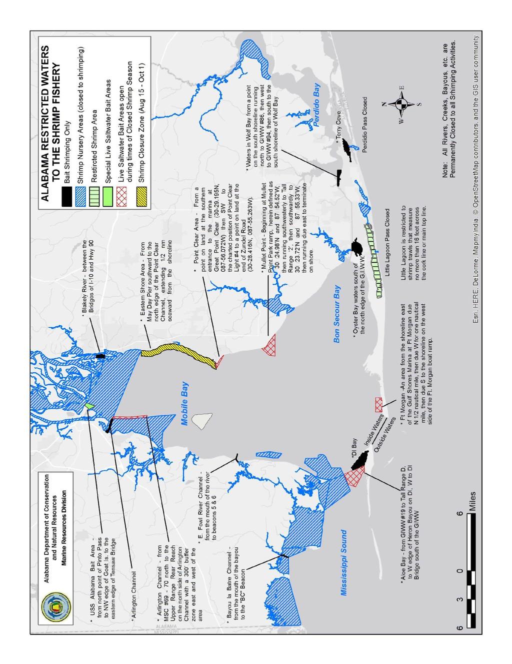
1 K STATE OF ALABAMA DEPARTMENT OF CONSERVATION AND NATURAL RESOURCES MARINE RESOURCES DIVISION POST OFFICE BOX 189 DAUPHIN ISLAND, AL TEL (251) FAX (251) APRIL 2017 COMMERCIAL SHRIMPING REGULATIONS THIS IS NOT AN OFFICIAL COPY OF THE LAWS OR REGULATIONS THIS EXPLANATION OF THE LAWS AND REGULATIONS IS CORRECTAS OF THE DATE SPECIFIED. BEFORE TAKING PART IN THIS FISHERY PLEASE CALL OR OR VISIT OUR WEBSITE FOR UPDATED INFORMATION. IT IS THE FISHERMAN S RESPONSIBILITY TO KNOW THE LAWS AND REGULATIONS IN EFFECT AT ANY GIVEN TIME. Definition: License: The taking or attempting to take shrimp by any trawl or trawls used together which exceed 16 as measured along the main top line; as well as, the taking or attempting to take shrimp by any trawl 16 or less while licensed as a commercial shrimp boat. License is issued to boat and cannot be transferred. Boat less than 30 feet: $61.00 Boat feet: $91.00 Boat over 45 feet: $ Commercial shrimp boat decal should be displayed on the port side of the vessel Non-residents pay a license fee equal to that paid by Alabama residents or boats to shrimp in their state but no less than double the amount provided for above. Non-resident licenses are sold only by Marine Resources Division offices. Persons trawling for crabs for commercial purposes or selling crabs taken incidentally while shrimping must have a $61.00 crab license. Shrimp and bycatch can be sold only to an Alabama seafood dealer unless the shrimper possesses a $ seafood dealers license (must meet requirements for license). Season: All inside waters close to commercial and recreational shrimping from 6:00 am May 1 to 6:00 am June 1 of each year. The area in Mobile Bay from the center of May Day Pier out to ½ nautical mile then south to the northern edge of Point Clear Channel shall be closed 6:00 a.m., August 15 th, until 6:00 a.m., October 1 st of each year. Pounds allowed: Mesh Size: Trawl Size: Other: No limit No restriction In inside waters (bays, sounds, etc.) a trawl or trawls used together cannot exceed 50 feet as measured along the main top line. No more than two trawls may be used at the same time (not including a try trawl, which cannot exceed 10 feet as measured along the top line). No restrictions on trawl size offshore (Gulf of Mexico). It is unlawful for any person to drag an net, seine, or trawl over public or private oyster reefs. Commercially licensed boats cannot shrimp in exclusive bait areas. It is unlawful to retain gamefish which includes: red drum, spotted seatrout, tarpon, and striped bass caught with a trawl. It is unlawful to discard dead fish or other dead seafood within 500 feet of any shoreline or into the waters of the Gulf of Mexico within 3 miles of the Gulf beaches (includes Pelican Bay). The use of any trawl or trawls, or the taking of shrimp by any means, in any area closed to commercial shrimping is hereby expressly prohibited. Little Lagoon is closed to all shrimp trawls which exceed sixteen feet as measured across the cork line or top main line (Reg MR-2, Rule ).
2 PERMANENTLY CLOSED AREAS (SHRIMP TAKEN BY ANY METHOD SHALL BE RETAINED) 1. All rivers*, streams, bayous, and creeks within the State (except Bayou St. John, Old River in Baldwin County and that portion of Blakeley River Designated by law as an exclusive bait shrimp area). *The mouth of the Mobile River is defined as a line running from the southernmost point of Pinto Island due west to a point of the mainland. The mouth of Blakeley River channel is defined as a line running westward from the charted position of the Blakeley River channel marker #18 to a point of intersection with land on the southern tip of Big Island ( N, W). 2. All of Portersville Bay inside a line running from Barron Point west along the south shores of Cat and Marsh Island then west to the south end of Coffee Island (Isle aux Herbes) then north along the western Shore of Coffee Island to a point on the mainland directly north of the northernmost tip of Coffee Island (Isle aux Herbes). 3. Heron Bay and that portion of Mississippi Sound north of the Gulf Intracoastal Waterway and east of a line extending from Barron Point on Mon Louis Island southeasterly to range marker D on the Intracoastal Waterway. 4. All of Weeks Bay. 5. Theodore Industrial Canal. 6. Bon Secour Bay within 2500 ft. of the mouth of Weeks Bay. 7. All waters north of the Battleship Parkway. 8. That portion of Mobile Bay north and west of a line running from the intersection of the Dog River Bridge with the Dog River Channel east along the northern edge of the Dog River Channel to its intersection with the Mobile Ship Channel (MSC) then north along the west side of the MSC to the Upper Reach Rear Range (located on the north side of the Arlington Channel) then north and east of a line running southeast to the charted position of the center of Mayday Pier ( N, W) then eastward along the center of the Mayday Pier to its intersection with land. There shall be a 300 foot safety buffer along the western edge of the MSC where towing a trawl shall be allowed for turning by vessels. 9. All waters in Mobile County north of a line beginning at the Mississippi State Line running east to the eastern tip of South Rigolets ( N, W) then northeast to the southwest tip of Point Aux Pins ( N, W) then east to the charted position of the BC Beacon in the Bayou La Batre Ship Channel and then southeast to the northwest point of the middle cut that bisects Coffee Island (Isle aux Herbes) defined as N, W. 10. North of Lillian Bridge in Baldwin County. 11. Little Lagoon Pass in Baldwin County. 12. Perdido Pass in Baldwin County which is definced as those water north of Perdido Pass Chanel markers #1 and #2 and south of the charted position of channel marker #12 in Terry Cove. 13. Exclusive bait areas are permanently closed to commercial shrimping. Note: Indian Bay and Lafitte Bay bottoms (Dauphin Island) are privately owned and may be closed to shrimping.
3 EXCLUSIVE BAIT AREAS (Closed to Commercial Shrimping) (Areas open only to licensed recreational shrimping and live saltwater bait dealers) (Shrimp may only be taken from these exclusive areas from 4:00 a.m. 10:00 p.m.) Baldwin County 1. Wolf Bay: that area encompassing the water within the boundary from the south shore of Wolf Bay northward to Beacon #86 on the north side of the Gulf Intracoastal Waterway then westward along the north side of the Gulf Intracoastal Waterway to Beacon #94 then south across the Gulf Intracoastal Waterway to the south shore of Wolf Bay. 2. Oyster Bay: that area encompassing those waters of Oyster Bay except those waters north of the Gulf Intracoastal Waterway (GIWW). 3. Blakely River: that area encompassing those waters in the mouth of the Blakeley River between the I-10 bridge and the Highway 90 (old causeway) bridge. 4. Terry Cove 1. Arlington Channel Mobile County 2. East Fowl River Channel: from Beacon 5 and 6 to the mouth of the river 3. Bayou la Batre Channel: From Bayou la Batre Channel B.C. Beacon to the mouth of Bayou la Batre 4. Dauphin Island Bay 5. Buchanan Bay, Confederate Pass, British Bay, Columbia Bay, Colony Bay (Colony Cove), Spanish Bay, Barcelona Bay. SEASONAL BAIT AREAS (Areas open exclusively to the commercial and recreational taking of live saltwater bait when adjacent water are closed) Baldwin County 1. Point Clear: that area beginning at a point of land at the southern entrance to the marina at Great Point Clear ( N, W) than southwestwardly to the charted position of Point Clear light #4 then running southeastwardly to a point of land at the end of Zundel Road ( N, W) 2. Mullet Point: beginning at Mullet Point Park ramp then running southwesterly to Tall Rand 2, the southwardly to a point ( N, W), then running due east to terminate on the shore. 3. Ft. Morgan beginning at the shoreline east of the Gulf Shores Marina at Ft Morgan due north one-half nautical mile, then due west for one nautical mile, then due south to the shoreline on west side of the Ft. Morgan boat ramp. The area is defined by the following corner points; NW N, W; NE N, W; SW N, W; SE N, W.
4 FEDERAL REGULATIONS Turtle Excluder Devices (TEDS): For the latest rules contact National Marine Fisheries Service (NMFS) at (727) For technical assistance call (228) SHRIMP TRAWLER: On-board or landed catch of shrimp is more than 1% by weight of all fish comprising on-board or landed catch. All shrimp trawlers in state and federal waters must us a Turtle Excluder Device. (See Exemptions) TED EXEMPTIONS: 1. A shrimp trawler with no power or mechanical advantage trawl retrieval system on board (i.e. all gear is retrieved by hand). 2. A shrimp trawler fishing only with a pusher-head trawl ( chopstick rig ), skimmer trawl, or wing net ( butterfly net ). 3. Single test net (try net) with head rope length 20 feet or less; State water try net cannot exceed 10 feet. 4. Beam or roller trawl fished without doors, boards, or similar devices. 5. Royal red shrimp fishermen if 90% of their catch by weight is royal red shrimp. LICENSE PURCHASING: NOTE: Licenses may be purchased online at or by mail. Make check or money order payable to: Marine Resources Division. Mail to: License Clerk License Clerk Marine Resources Division Marine Resources Division P.O. Box 189 P.O. Drawer 458 Dauphin Island, AL Gulf Shores, AL Be sure to include a copy of the boat registration/documentation, copy of owner s driver license, a stamped, self-addressed envelope.
5
OCTOBER 2018 COMMERCIAL SHRIMPING REGULATIONS
 STATE OF ALABAMA DEPARTMENT OF CONSERVATION AND NATURAL RESOURCES MARINE RESOURCES DIVISION POST OFFICE BOX 189 DAUPHIN ISLAND, AL 36528 TEL (251) 861-2882 FAX (251) 861-8741 OCTOBER 2018 COMMERCIAL SHRIMPING
JUNE 2018 RECREATIONAL SHRIMPING REGULATIONS
 K STATE OF ALABAMA DEPARTMENT OF CONSERVATION AND NATURAL RESOURCES MARINE RESOURCES DIVISION POST OFFICE BOX 189 DAUPHIN ISLAND, AL 36528 TEL (251) 861-2882 FAX (251) 861-8741 JUNE 2018 RECREATIONAL SHRIMPING
JUNE 2018 RECREATIONAL SHRIMPING REGULATIONS
 K STATE OF ALABAMA DEPARTMENT OF CONSERVATION AND NATURAL RESOURCES MARINE RESOURCES DIVISION POST OFFICE BOX 189 DAUPHIN ISLAND, AL 36528 TEL (251) 861-2882 FAX (251) 861-8741 JUNE 2018 RECREATIONAL SHRIMPING
August 2018 LIVE BAIT
 STATE OF ALABAMA DEPARTMENT OF CONSERVATION AND NATURAL RESOURCES MARINE RESOURCES DIVISION POST OFFICE BOX 189 DAUPHIN ISLAND, ALABAMA 36528 TEL (251861-2882 FAX (251) 861-8741 August 2018 LIVE BAIT THIS
APRIL 2017 LIVE BAIT
 K STATE OF ALABAMA DEPARTMENT OF CONSERVATION AND NATURAL RESOURCES MARINE RESOURCES DIVISION POST OFFICE BOX 189 DAUPHIN ISLAND, ALABAMA 36528 TEL (251861-2882 FAX (251) 861-8741 APRIL 2017 LIVE BAIT
Use Of Nets And Harvest Of Mullet.
 220-3. 03 Use Of Nets And Harvest Of Mullet. (1) Any person possessing, transporting, or using any seine, gill net, trammel net, or other entangling net more than 300 feet in length as measured along the
Conservation and Natural Resources Chapter ALABAMA DEPARTMENT OF CONSERVATION AND NATURAL RESOURCES ADMINISTRATIVE CODE
 ALABAMA DEPARTMENT OF CONSERVATION AND NATURAL RESOURCES ADMINISTRATIVE CODE CHAPTER 220-3 MARINE RESOURCES DIVISION TABLE OF CONTENTS 220-3-.01 Shrimping 220-3-.02 Oystering 220-3-.03 Use Of Nets And
***This summary does not include shad and herring net requirements.***
 South Carolina Department of Natural Resources Marine Resources Division Summary of Seine and Gill Net Laws (Saltwater) 2013-2014 This document should be kept on board all vessels using seines or gill
15A NCAC 03J.0103 is amended with changes as published in 30:03 NCR as follows:
 1 1 1 1 1 1 1 1 0 1 0 1 1A NCAC 0J.0 is amended with changes as published in 0:0 NCR 1- as follows: 1A NCAC 0J.0 GILL NETS, SEINES, IDENTIFICATION, RESTRICTIONS (a) It is unlawful to use gill nets: (1)
A SU~~ ()t= MAl:21~~ t=ist-11~«7 IAWS ~() l2~f7uia Tl()~S t=()l2 Tll~ f7ult= STAT~S*
t= MAl:21~~ t=ist-11~«7 IAWS ~() l2~f7uia Tl()~S t=()l2 Tll~ f7ult= STAT~S*") A SU~~ ()t= MAl:21~~ t=ist-11~«7 IAWS ~() l2~f7uia Tl()~S t=()l2 Tll~ f7ult= STAT~S* *An unofficial compilation of marine fishing laws and regulations developed for the information and convenience of enforcement
A SU~~ ()t= MAl:21~~ t=ist-11~«7 IAWS ~() l2~f7uia Tl()~S t=()l2 Tll~ f7ult= STAT~S* *An unofficial compilation of marine fishing laws and regulations developed for the information and convenience of enforcement
GULF STATES MARINE FISHERIES COMMISSION. Law Summary A Summary of Marine Fishing Laws and Regulations for the Gulf States
 GULF STATES MARINE FISHERIES COMMISSION Law Summary 1998 A Summary of Marine Fishing Laws and Regulations for the Gulf States December 1998 GSMFC No. 61 This publication is an unofficial compilation of
Columbia River Fishery Notice
 Columbia River Fishery Notice Oregon Department of Fish and Wildlife January 29, 2014 Compact Action The Columbia River Compact agencies of Oregon and Washington met today and took the following actions:
Columbia River Fishery Notice
 Columbia River Fishery Notice Oregon Department of Fish and Wildlife July 26, 2018 Compact Action The Columbia River Compact agencies of Oregon and Washington met today and took the following actions:
OREGON AND WASHINGTON DEPARTMENTS OF FISH AND WILDLIFE JOINT STAFF REPORT SUMMER FACT SHEET NO.
 OREGON AND WASHINGTON DEPARTMENTS OF FISH AND WILDLIFE JOINT STAFF REPORT SUMMER FACT SHEET NO. 1b Columbia River Compact/Joint State Hearing June 14, 2017 Fisheries under consideration: Estuary Recreational
Final Environmental Impact Statement. for the
 Final Environmental Impact Statement for the Generic Essential Fish Habitat Amendment to the following fishery management plans of the Gulf of Mexico (GOM): SHRIMP FISHERY OF THE GULF OF MEXICO RED DRUM
SUBCHAPTER 03L SHRIMPS, CRAB, AND LOBSTER SECTION SHRIMP
 SUBCHAPTER 03L SHRIMPS, CRAB, AND LOBSTER SECTION.0100 - SHRIMP 15A NCAC 03L.0101 SHRIMP HARVEST RESTRICTIONS (a) It is unlawful to take shrimp until the Fisheries Director, by proclamation, opens the
PROPOSED AMENDMENTS TO THE REGULATIONS of the POTOMAC RIVER FISHERIES COMMISSION September 8, NOTICE OF HEARING September 8, 2016
 of the POTOMAC RIVER FISHERIES COMMISSION September 8, 2016 Pursuant to the Potomac River Compact of 1958, as duly enacted into law by the General Assemblies of the States of Maryland and Virginia and
BLACK SEA BASS NORTH OF CAPE HATTERAS DEALER PERMIT ISSUE PAPER. June 12, 2008 (REVISED) (NOTE: proposed rule under construction, eff.
 (NOTE: proposed rule under construction, eff.") BLACK SEA BASS NORTH OF CAPE HATTERAS DEALER PERMIT ISSUE PAPER June 12, 2008 (REVISED) (NOTE: proposed rule under construction, eff. July 1, 2008) I. ISSUE The requirement for licensed dealers to have
BLACK SEA BASS NORTH OF CAPE HATTERAS DEALER PERMIT ISSUE PAPER June 12, 2008 (REVISED) (NOTE: proposed rule under construction, eff. July 1, 2008) I. ISSUE The requirement for licensed dealers to have
VIRGINIA: CitJto/~<Pn Friday 1st day 0/ November, Fee 4. Parking or Stopping Violations * * *
 VIRGINIA: CitJto/~
Submitted by the Alaska Department of Fish and Game at the request of Alaska Board of Fisheries. January 23, 2018
 Submitted by the Alaska Department of Fish and Game at the request of Alaska Board of Fisheries. January 23, 2018 Alaska Board of Fisheries recommendations on Unuk, Chilkat, and King Salmon rivers king
68B-31 CHAPTER 68B-31 SHRIMP
 CHAPTER 68B-31 SHRIMP 68B-31.001 Northeast Florida Live Bait Shrimp Fishery; Purpose and Intent. 68B-31.002 Definitions. 68B-31.003 Live Bait Shrimp Trawl Gear Specifications. 68B-31.0035 Trawls: Allowed
Okeechobee Waterway Speed Restrictions
 Okeechobee Waterway Speed Restrictions Rulemaking Authority 327.46 FS. Law Implemented 327.46 FS. History New 9-18-88, Amended 12-7-89, Formerly 16N-24.010, Amended 10-1- 96, Formerly 62N-24.010, Amended
GULF STATES MARINE FISHERIES COMMISSION. Law Summary. A Summary of Marine Fishing Laws and Regulations for the Gulf States
 GULF STATES MARINE FISHERIES COMMISSION Law Summary 1999 A Summary of Marine Fishing Laws and Regulations for the Gulf States December 1999 GSMFC No. 70 This publication is an unofficial compilation of
License & Fees for Alabama, Florida, Louisiana, Mississippi, and Texas in Their Marine Waters for the Year 2013
 License & Fees for Alabama, Florida, Louisiana, Mississippi, and Texas in Their Marine Waters for the Year 2013 Gulf States Marine Fisheries Commission September 2014 No 233 Gulf States Marine Fisheries
FISCAL IMPACTS OF PROPOSED AMENDMENTS TO RULES 15A NCAC 03J.0209, 03R and 03R.0201
 FISCAL IMPACTS OF PROPOSED AMENDMENTS TO RULES 15A NCAC 03J.0209, 03R. 0112 and 03R.0201 ALBEMARLE SOUND MANAGEMENT AREA SOUTHERN BOUNDARY COORDINATE CHANGE Marine Fisheries Commission (MFC) Agency Contact:
REQUEST FOR TECHNICAL CHANGE
 REQUEST FOR TECHNICAL CHANGE AGENCY: Marine Fisheries Commission RULE CITATION: 1A NCAC 0J.0 DEADLINE FOR RECEIPT: Wednesday, January 1, 01 NOTE WELL: This request when viewed on computer extends several
Law Summary A SuD11Dary of Marine Fishing Laurs and Regulations for tl1e Gulf States
 GULF STATES MARINE FISHERIES COMMISSION Law Summary 1997 --.. - ---... --- ---- A SuD11Dary of Marine Fishing Laurs and Regulations for tl1e Gulf States September 1997 GSMFCNo.49 This publication is an
SEAGRANTPROGRAM LAGNIAPPE
 Agricultural Center Louisiana Cooperative State University Extension Service Jefferson Parish Office 1825BonnieAnnDrive Marrero, LA 70072 (504) 349-5640 March 20, 1992 Volume 16, No. 3 SEAGRANTPROGRAM
Commercial Saltwater Fishing Regulations
 Commercial Saltwater Fishing Regulations Printed March 2018 Table of Contents ABBREVIATIONS... 3 DEFINITIONS... 3 GENERAL REQUIREMENTS... 4 COMMERCIAL LICENSES... 4 Commercial Fishing License... Error!
License & Fees for Alabama, Florida, Louisiana, Mississippi, and Texas in Their Marine Waters for the Year 2016
 License & Fees for Alabama, Florida, Louisiana, Mississippi, and Texas in Their Marine Waters for the Year 2016 Gulf States Marine Fisheries Commission July 2017 No. 265 Gulf States Marine Fisheries Commission
Point No Point Treaty Council
 Point No Point Treaty Council Port Gamble S'Kiallam Jamestown S'Kiallam 2016-2017 Point No Point Treaty Council In-Common Commercial and Subsistence Dungeness Crab Fishery Regulations #S16-052 The following
Reef Fish Amendment 32 Gag and Red Grouper
 AMENDMENT GUIDE 11/2/11 Reef Fish Amendment 32 Gag and Red Grouper Provisions in the Magnuson-Stevens Fishery Conservation and Management Act require regional fishery management councils to develop annual
FISCAL IMPACTS OF PROPOSED AMENDMENTS TO THE N.C. RIVER HERRING FISHERY MANAGEMENT PLAN
 1 FISCAL IMPACTS OF PROPOSED AMENDMENTS TO THE N.C. RIVER HERRING FISHERY MANAGEMENT PLAN Rule Amendments: Name of Commission: Agency Contact: 15A NCAC 03J.0209 ALBEMARLE SOUND/CHOWAN RIVER RIVER HERRING
License & Fees for Alabama, Florida, Louisiana, Mississippi, and Texas in Their Marine Waters for the Year 2017
 License & Fees for Alabama, Florida, Louisiana, Mississippi, and Texas in Their Marine Waters for the Year 2017 Gulf States Marine Fisheries Commission August 2018 No. 278 Gulf States Marine Fisheries
Georgia Department of Natural Resources Coastal Resources Division Management Plan: Penaeid Shrimp June 2017
 Georgia Department of Natural Resources Coastal Resources Division Management Plan: Penaeid Shrimp June 2017 General Objective: Manage Georgia s penaeid shrimp (i.e., white, brown and pink shrimp) fishery
Geographic Response Plan Map: SC-17
 79 37'30"W Geographic Response Plan Map: SC-17 79 30'0"W 33 7'30"N Charleston County 33 7'30"N 33 0'0"N 79 37'30"W [ Awendaw [j [e!d!s(!d Graham Creek FRANCIS MARION NATIONAL FOREST 450 Awendaw Creek [j
License & Fees for Alabama, Florida, Louisiana, Mississippi, and Texas in Their Marine Waters for the Year 2015
 License & Fees for Alabama, Florida, Louisiana, Mississippi, and Texas in Their Marine Waters for the Year 2015 Gulf States Marine Fisheries Commission August 2016 No. 253 Gulf States Marine Fisheries
FISCAL NOTE FOR PROPOSED AMENDMENTS TO RULE 15A NCAC 03O A NCAC 03O.0503 PERMIT CONDITIONS; SPECIFIC
 FISCAL NOTE FOR PROPOSED AMENDMENTS TO RULE 15A NCAC 03O.0503 SPINY DOGFISH DEALER PERMIT Rule Amendments: Name of Commission: Agency Contact: Impact Summary: 15A NCAC 03O.0503 PERMIT CONDITIONS; SPECIFIC
Fishing for Red Drum
 Fishing for Red Drum Overview: Grade Level 5 th -8 th Objectives * To be able generate a graph based on current fishery data. * To be able to predict red drum weights and ages based on length. * To understand
Framework 35 Northeast Multispecies FMP
 and 2. In addition to small mesh multispecies, vessels target herring in Small Mesh Areas 1 and 2 and therefore use mesh smaller than 2.5-inches in the codend. The net specifications listed in Section
SECTION II NM 11/13 NAVIGATION PUBLICATIONS COAST PILOT CORRECTIONS. Chapter 4 Paragraphs 85 to 86; read: (85)
") NAVIGATION PUBLICATIONS COAST PILOT CORRECTIONS COAST PILOT 1 42 Ed 2012 Change No. 13 LAST NM 9/13 Chapter 4 Paragraph 9; read: (9) Round Rock, which uncovers, and The Boring Stone, 3 feet high and bare,
NAVIGATION PUBLICATIONS COAST PILOT CORRECTIONS COAST PILOT 1 42 Ed 2012 Change No. 13 LAST NM 9/13 Chapter 4 Paragraph 9; read: (9) Round Rock, which uncovers, and The Boring Stone, 3 feet high and bare,
PRAWN FISHERY MANAGEMENT PLAN, 2010
 PRAWN FISHERY MANAGEMENT PLAN, 2010 [L.N. 20/2011.] SCHEDULE 1. Citation This Management Plan shall be cited as The Prawn Fishery Management Plan 2010 hereinafter referred to as The Management Plan. 2.
CHAPTER 260. (House Bill 964) Atlantic Coastal Bays Dredging for Oysters and Clams Prohibition
 Atlantic Coastal Bays Dredging for Oysters and Clams Prohibition") MARTIN O MALLEY, Governor Ch. 260 CHAPTER 260 (House Bill 964) AN ACT concerning Atlantic Coastal Bays Dredging for Oysters and Clams Prohibition FOR the purpose of prohibiting the use of dredging to catch
MARTIN O MALLEY, Governor Ch. 260 CHAPTER 260 (House Bill 964) AN ACT concerning Atlantic Coastal Bays Dredging for Oysters and Clams Prohibition FOR the purpose of prohibiting the use of dredging to catch
OfflGE COPY ONLY. LICENSES/FEES Required by Alabama, Florida, Louisiana, Mississippi and Texas in Their Marine Waters
 OfflGE COPY ONLY LICENSES/FEES Required by Alabama, Florida, Louisiana, Mississippi and Texas in Their Marine Waters Licenses/Fees Required by Alabama, Florida, Louisiana, Mississippi and Texas in Their
Harbor Porpoise Take Reduction Plan: New England
 Harbor Porpoise Take Reduction Plan: New England Photo Ann-Louise Jensen / Fjord & Bælt Centre NOAA Fisheries Service U.S. Department of Commerce National Oceanic and Atmospheric Administration National
What are the most recent changes to the Fisheries Regulations in The Bahamas?
 SPORT FISHING What are the most recent changes to the Fisheries Regulations in The Bahamas? Sharks are now protected in The Bahamas as a result of an amendment made in 2011. Sharks may only be taken under
UNOFFICIAL COPY OF HOUSE BILL 853 CHAPTER
 UNOFFICIAL COPY OF HOUSE BILL 853 M2 6lr1662 By: Delegates Bozman, Cane, V. Clagett, Conway, and Hixson Introduced and read first time: February 8, 2006 Assigned to: Environmental Matters Committee Report:
Amendment 1 to the NC Red Drum FMP MFC Meeting
 Amendment 1 to the NC Red Drum FMP MFC Meeting 4-22-2008 Summary of DMF and AC Recommendations and Public Comment Inland AC Raleigh 3/4/08 Central AC New Bern 3/5/08 Northeast AC Buxton 3/6/08 Southeast
ELWHA FISHERIES OFFICE
 ELWHA FISHERIES OFFICE 760 Stratton Rd (360) 457-4012 Port Angeles, WA 98363 FAX: (360) 452-4848 July 8, 2017 LOWER ELWHA KLALLAM TRIBE Commercial and Subsistence Dungeness Crab Fishery Regulations S17-035
Bering Sea Salmon Bycatch Update North Pacific Fishery Management Council, July 2017
 Bering Sea Salmon Bycatch Update North Pacific Fishery Management Council, July 2017 Salmon are caught incidentally in the Bering Sea and Aleutian Islands (BSAI) offshore trawl fisheries, especially in
WATER SURFACE USE ORDINANCE STATE OF MINNESOTA COUNTY OF CROW WING ORDINANCE NO. 83
 WATER SURFACE USE ORDINANCE STATE OF MINNESOTA COUNTY OF CROW WING ORDINANCE NO. 83 AN ORDINANCE REGULATING THE SURFACE USE OF ALL WATERS OF CROW WING COUNTY Be it ordained and enacted by the Crow Wing
License & Fees for. .-!! aba 111a, Florida, Louisiau a, Jlississippi, au d Te-:\. as iu Their Jlariue TJ(1ters for the I ear :010. Se1>t 2011 No.
 License & Fees for.-!! aba 111a, Florida, Louisiau a, Jlississippi, au d Te-:\. as iu Their Jlariue TJ(1ters for the I ear :010 f-tjli f). Se1>t 2011 No. 193 Gulf States Marine Fisheries Commission Commissioners
RULES OF GEORGIA DEPARTMENT OF NATURAL RESOURCES COASTAL RESOURCES DIVISION CHAPTER SALTWATER FISHING REGULATIONS TABLE OF CONTENTS
 Saltwater Fishing Regulations Chapter 391-2-4 RULES OF GEORGIA DEPARTMENT OF NATURAL RESOURCES COASTAL RESOURCES DIVISION CHAPTER 391-2-4 SALTWATER FISHING REGULATIONS TABLE OF CONTENTS 391-2-4-.09 Commercial
Coastal Wetlands Protection Act. Fisheries Management, Marine Sanctuaries and Closures
 , STATE AND LOCAL AUTHORITY FOR MARINE PROTECTION (2014). MISSISSIPPI 1 State Authority for Protection Summary of State Authorities Mississippi has several options for conserving marine habitat; however,
ELWHA FISHERIES OFFICE
 ELWHA FISHERIES OFFICE 760 Stratton Road (360) 457-4012 Port Angeles, WA 98363 FAX: (360) 452-4848 LOWER ELWHA KLALLAM 2018 Annual In-Common Shrimp Regulation S18-019 April 23, 2018 The following regulation
Lake Seminole. and Waters Bordering Georgia and Alabama
 Lake Seminole and Waters Bordering Georgia and Alabama LAKE SEMINOLE Site Description Lake Seminole is a 37,500-acre reservoir located at the juncture of the Florida, Georgia, and Alabama state lines.
REEL FACTS. Regulations. Limblines Fishing with limblines and set hooks is prohibited at Lake Washington.
 Lake Washington 19 REEL FACTS Nathan Aycock Fisheries Biologist NathanA@mdwfp.state.ms.us (61) 432-2 General Information: Lake Washington is a 3, acre oxbow lake of the Mississippi River. It is one of
Louisiana Shrimp Action Plan
 Louisiana Shrimp Action Plan Updated May 2017 Prepared by: Audubon Nature Institute Gulf United for Lasting Fisheries (G.U.L.F.) Laura Picariello - Technical Programs Manager Ashford Rosenberg - Outreach
XXX. Chisolm Island Creeks. Map Continued on SC-48. Judge Island. SC49-03 Jenkins Creek/Morgan River Intersection XXX. Saint Helena Island
 w River 32 30'0"N ufort County 80 37'30"W 802 Coosaw River 250 450 SC41-05 Geographic Response SC41-03 Plan Map: Coosaw SC-49 River Chisolm Island Chisolm Island s u Map Continued on SC-41 3 (west side)
MENHADEN MANAGEMENT FOR THE ATLANTIC OCEAN REDUCTION FISHERY INFORMATION PAPER. September 24, 2009
 MENHADEN MANAGEMENT FOR THE ATLANTIC OCEAN REDUCTION FISHERY INFORMATION PAPER September 24, 2009 I. ISSUE Conflict between recreational anglers, the reduction fishery, and bycatch II. ORIGINATION Marine
68D Broward County Boating Restricted Areas.
 68D-24.008 Broward County Boating Restricted Areas. (1) For the purpose of regulating speed and operation of vessel traffic on and adjacent to the Florida Intracoastal Waterway in Broward County, Florida,
ELWHA FISHERIES OFFICE
 ELWHA FISHERIES OFFICE 760 Stratton Rd (360) 457-4012 Port Angeles, WA 98363 FAX: (360) 452-4848 June 7, 2018 LOWER ELWHA KLALLAM TRIBE Commercial and Subsistence Dungeness Crab Fishery Regulations S18-035
MISSISSIPPI DEPARTMENT OF WILDLIFE, FISHERIES, AND PARKS RULE 5.3 ALLIGATOR HUNTING SEASON FOR PUBLIC WATERS.
 MISSISSIPPI DEPARTMENT OF WILDLIFE, FISHERIES, AND PARKS Title 40: Wildlife, Fisheries, and Parks Part 2: Wildlife Part 2, Chapter 5: Regulations regarding alligators. RULE 5.3 ALLIGATOR HUNTING SEASON
U.S. National Observer Program, Southeast Regional Fishery Observer Programs & Regional Electronic Technology Implementation Plans Jane DiCosimo
 Tab A, No. 7 Office of Science and Technology Silver Spring, MD U.S. National Observer Program, Southeast Regional Fishery Observer Programs & Regional Electronic Technology Implementation Plans Jane DiCosimo
GULF SHORES & ORANGE BEACH FISHING YOU LL FIND YOURSELF HOOKED THE MINUTE YOU CAST YOUR LINE.
 GULF SHORES & ORANGE BEACH FISHING YOU LL FIND YOURSELF HOOKED THE MINUTE YOU CAST YOUR LINE. The sun sparkling on the Gulf water is almost as magnificent as the catch you ve been fighting on the end of
BookletChart. Intracoastal Waterway Matecumbe to Grassy Key NOAA Chart A reduced-scale NOAA nautical chart for small boaters
 BookletChart Intracoastal Waterway Matecumbe to Grassy Key NOAA Chart 11449 A reduced-scale NOAA nautical chart for small boaters When possible, use the full-size NOAA chart for navigation. Published by
Modeling effects of fishing closures in the Western Florida Shelf
 Modeling effects of fishing closures in the Western Florida Shelf David J. Die and Steven Saul* University of Miami * Currently SEFSC/NMFS/NOAA Outline Effects of fishing closures DWH Fishing closures
MIAMI-DADE COUNTY MANATEE PROTECTION AREAS AND BOATING RESTRICTED AREAS
 MANATEE PROTECTION AREAS AND BOATING RESTRICTED AREAS For description of zone boundaries see: 68C-22.025 F.A.C for State Manatee Protection Zones last amended 2/25/99 68D-24.03 F.A.C. for State Boating
State of Texas Operations and Maintenance
 State of Texas Operations and Maintenance Barbour Terminal Ship Channel The Barbour Terminal Channel and Turning Basin is a 1.7-mile-long deep draft waterway that extends from the Houston Ship Channel
Licenses & Fees. For Alabama, Florida, Louisiana, Mississippi, and Texas In Their Marine Waters for the Year March 2005 No.
 Licenses & Fees For Alabama, Florida, Louisiana, Mississippi, and Texas In Their Marine Waters for the Year 2004 March 2005 No. 130 Licenses & Fees For Alabama, Florida, Louisiana, Mississippi, and Texas
Executive Summary to the Annual Report. Marine Fisheries Initiative (MARFIN) Gulf of Mexico. 1 October September 1988.
 Gulf of Mexico. 1 October September 1988.") Executive Summary to the Annual Report Marine Fisheries Initiative (MARFIN) Gulf of Mexico 1 October 1987-30 September 1988 June 1989 Gulf States Marine Fisheries Commission Executive Summary to the Annual
Executive Summary to the Annual Report Marine Fisheries Initiative (MARFIN) Gulf of Mexico 1 October 1987-30 September 1988 June 1989 Gulf States Marine Fisheries Commission Executive Summary to the Annual
(e) For the purpose of this section, a menhaden dealer is:
 For the purpose of this section, a menhaden dealer is:") Fis 603.21 Atlantic Menhaden. (a) No person shall take, land, possess, or transfer possession of Atlantic menhaden (Brevortia tyrannus) while on or leaving the waters under the jurisdiction of the state
Fis 603.21 Atlantic Menhaden. (a) No person shall take, land, possess, or transfer possession of Atlantic menhaden (Brevortia tyrannus) while on or leaving the waters under the jurisdiction of the state
For-hire Data Collection. Gulf of Mexico Fishery Management Council Red Snapper For-hire Advisory Panel December 2-3, 2014 Tampa, FL
 For-hire Data Collection Gulf of Mexico Fishery Management Council Red Snapper For-hire Advisory Panel December 2-3, 2014 Tampa, FL Southeast Region Recreational Surveys MRIP For-hire Survey APAIS/CHTS
TEXAS PARKS AND WILDLIFE DEPARTMENT LAW ENFORCEMENT DIVISION FISHERIES ENFORCEMENT ALONG THE TX/MX BORDER
 TEXAS PARKS AND WILDLIFE DEPARTMENT LAW ENFORCEMENT DIVISION FISHERIES ENFORCEMENT ALONG THE TX/MX BORDER REGION 8 JOINT IUU OPERATIONS CAMERON/HIDALGO COUNTIES - PORTS OF ENTRY FEBRUARY 2018 PARTICIPATING
TITLE 22 MISSISSIPPI DEPARTMENT OF MARINE RESOURCES
 TITLE 22 MISSISSIPPI DEPARTMENT OF MARINE RESOURCES PART 8 RULES AND REGULATIONS FOR OFFICIAL STANDARDS OF MEASURE AND DEFINITIONS FOR MARINE FISHERIES IN THE STATE OF MISSISSIPPI Chapter 01 Introduction
SUBSIDIARY LEGISLATION FISHERIES REGULATIONS
 Chap. 67:51 7 SUBSIDIARY LEGISLATION FISHERIES REGULATIONS ARRANGEMENT OF REGULATIONS REGULATION Citation 2. Nets. 2A. Use of monofilament nets and mesh. 3. Piah leas thun twelve inches. 4. Fish less than
LICENSES & FEES GULF STATES MARINE FISHERIES COMMISSION
 LICENSES & FEES for Alabama, Florida, Louisiana, Mississippi, and Texas in Their Marine Waters for the Year 2001 GULF STATES MARINE FISHERIES COMMISSION MAY 2002 NO. 100 LICENSES & FEES for Alabama, Florida,
Public Hearing Guide 02/2017. Shrimp Amendment 17B - Yield, Threshold Number of Permits and Transit Provisions
 Public Hearing Guide 02/2017 Shrimp Amendment 17B - Yield, Threshold Number of Permits and Transit Provisions Table of Contents What is a public hearing? 1 How does a public hearing affect fisheries management?
1. The authority citation for part 622 continues to read as
 For the reasons set out in the preamble, 50 CFR part 622 is proposed to be amended as follows: PART 622--FISHERIES OF THE CARIBBEAN, GULF OF MEXICO, AND SOUTH ATLANTIC 1. The authority citation for part
DEPARTMENT OF THE ARMY GALVESTON DISTRICT, CORPS OF ENGINEERS P.O. BOX 1229 GALVESTON, TEXAS CESWG-CDR (1145)
") DEPARTMENT OF THE ARMY GALVESTON DISTRICT, CORPS OF ENGINEERS P.O. BOX 1229 GALVESTON, TEXAS 77553-1229 REPLY TO ATTENTION OF CESWG-CDR (1145) TBD MEMORANDUM FOR All Galveston District Personnel. SUBJECT:
DEPARTMENT OF THE ARMY GALVESTON DISTRICT, CORPS OF ENGINEERS P.O. BOX 1229 GALVESTON, TEXAS 77553-1229 REPLY TO ATTENTION OF CESWG-CDR (1145) TBD MEMORANDUM FOR All Galveston District Personnel. SUBJECT:
Geographic Response Plan Map: SC-35 Pleasant Point. Map Continued on SC-36. SC35-05 Church Flats Creek. SC35-01 Mouth of Stono River XXX.
 wood [ 34-01 ogoodoo ek 32 45'0"N Map Continued on SC-34 32 37'30"N 80 15'0"W [y [ 80 15'0"W «165 «165 Meggett SC35-04 Wadmalaw River Wadmalaw River «165 Hollywood Martins Point [ SC35-03 Oyster House
STATE LEGISLATION AFFECTING MARINE FISHERIES - GULF OF MEXICO
 OFFICE COPY ONLY STATE LEGISLATION AFFECTING MARINE FISHERIES - GULF OF MEXICO 1991 prepared by Gulf States Marine Fisheries Commission P.O. Box 726 Ocean Springs, Mississippi 39564 August 1991 ( c c (
OREGON AND WASHINGTON DEPARTMENTS OF FISH AND WILDLIFE JOINT STAFF REPORT SUMMER FACT SHEET NO.
 OREGON AND WASHINGTON DEPARTMENTS OF FISH AND WILDLIFE JOINT STAFF REPORT SUMMER FACT SHEET NO. 1 Columbia River Compact/Joint State Hearing June 28, 2018 Fisheries under consideration: Treaty commercial
MIAMI-DADE COUNTY MANATEE PROTECTION AREAS
 MANATEE PROTECTION AREAS For description of zone boundaries see: 68C-22.025 F.A.C for State Manatee Protection Zones last amended 2/25/99 For infomation please call or write to: Fish and Wildlife Conservation
OFFICE COPY ONLY. STAT L G1SLAT10'N AFF CT1'NG MAR1'N TlSH R1 S GVLF OF M X1CO SEPTEMBER :r~-~-: :: h_.,; '...
 OFFICE COPY ONLY STAT L G1SLAT10'N AFF CT1'NG MAR1'N TlSH R1 S GVLF OF M X1CO - SEPTEMBER 1992 :: h_.,; '......-:r~-~-: INTRODUCTION LEGISLATION AFFECTING MARINE FISHERIES 1992 During its spring meeting
Boston Whaler Owners Event Stuart, Florida May 13-15
 Boston Whaler Owners Event Stuart, Florida May 13-15 Boston Whaler is pleased to present an official Boston Whaler Owners Event May 13-15, in Stuart, Florida. Boston Whaler owners, their families and guests
Pascagoula River Marsh 2017 REEL FACTS Stephen Brown Fisheries Biologist
 Pascagoula River Marsh 217 REEL FACTS Stephen Brown Fisheries Biologist stephenb@mdwfp.state.ms.us General Information: The Pascagoula River marsh is 25 acres of tidal creeks, canals, bays, and streams
December 15, Supplement to POTOMAC RIVER FISHERIES COMMISSION BOOK OF REGULATIONS
 December 15, 2017 Supplement to POTOMAC RIVER FISHERIES COMMISSION BOOK OF REGULATIONS This supplement should be inserted inside the back cover of the January 1, 2018 edition of the Potomac River Fisheries
1501: Seasons and limits on ducks, brant, geese, mergansers, and coots.
 ACTION: Original DATE: 02/10/2017 2:08 PM 1501:31-7-06 Seasons and limits on ducks, brant, geese, mergansers, and coots. (A) Throughout the state, it shall be unlawful for any person to hunt, kill, wound,
Wexford Harbour. Yachting Guide. Navigation
 Wexford Harbour Yachting Guide Navigation This document supersedes all previous editions. Approvals: Yacht Club Committee April, 2015 Wexford Board of Directors April, 2015 # Date Section Revision 1 6.5.2015
THE FISHERIES (GENERAL) REGULATIONS 1950, AMENDMENT NO. 36. DA VID BEATTIE, Governor-General ORDER IN COUNCIL
 REGULATIONS 1950, AMENDMENT NO. 36. DA VID BEATTIE, Governor-General ORDER IN COUNCIL") 1665 THE FISHERIES (GENERAL) REGULATIONS 1950, AMENDMENT NO. 36 DA VID BEATTIE, Governor-General ORDER IN COUNCIL At the Government House at Wellington this 27th day of October 1981 Present: HIS EXCELLENCY
1665 THE FISHERIES (GENERAL) REGULATIONS 1950, AMENDMENT NO. 36 DA VID BEATTIE, Governor-General ORDER IN COUNCIL At the Government House at Wellington this 27th day of October 1981 Present: HIS EXCELLENCY
THE FISHERIES (NELSON COMMERCIAL FISHING RESTRICTIONS) NOTICE 1984
 NOTICE 1984") THE FISHERIES (NELSON COMMERCIAL FISHING RESTRICTIONS) NOTICE 1984 PURSUANT to section 89 of the Fisheries Act 1983 and the Fisheries (Commercial Fishing) Regulations 1983, the Director-General ofagriculture
THE FISHERIES (NELSON COMMERCIAL FISHING RESTRICTIONS) NOTICE 1984 PURSUANT to section 89 of the Fisheries Act 1983 and the Fisheries (Commercial Fishing) Regulations 1983, the Director-General ofagriculture
SEA GRANTPROGRAM LAGNIAPPE
 Agricultural Center Louisiana State Cooperative University Extension Service Jefferson Perish Office 1825 Bonnie Ann Cnve Marrerm LA 70072 (504) 349-5640 October i0, 1992 Volume 16, No. 9 SEA GRANTPROGRAM
National Oceanic and Atmospheric Administration. Fisheries of the Caribbean, Gulf of Mexico, and South Atlantic;
 This document is scheduled to be published in the Federal Register on 11/02/2018 and available online at https://federalregister.gov/d/2018-23950, and on govinfo.gov BILLING CODE 3510-22-P DEPARTMENT OF
Fish Conservation and Management
 Fish Conservation and Management CONS 486 Fisheries Exploitation Chapters 4 and 5 Ross Fisheries Exploitation Fisheries sectors (i.e., user groups) Fisheries harvest methods Major theme: Linking science
Fish Conservation and Management
 Fish Conservation and Management CONS 486 Fisheries Exploitation Chapters 4 and 5 Ross Fisheries Exploitation Fisheries sectors (i.e., user groups) Fisheries harvest methods Major theme: Linking science
Pascagoula River Marsh 2018 REEL FACTS Stephen Brown Fisheries Biologist
 Pascagoula River Marsh 218 REEL FACTS Stephen Brown Fisheries Biologist stephenb@mdwfp.state.ms.us General Information: The Pascagoula River marsh is 25 acres of tidal creeks, canals, bays, and streams
VIRGINIA MARINE RESOURCES COMMISSION PLANS & STATISTICS VOLUME 13 ISSUE 1 Spring 2005
 VIRGINIA MARINE RESOURCES COMMISSION PLANS & STATISTICS 1-800-937-9247 VOLUME 13 ISSUE 1 Spring 2005 This newsletter provides only a summary of management measures adopted by the Commission and has no
CHAPTER Section 73 of P.L.1979, c.199 (C.23:2B-14) is amended to read as follows:
 is amended to read as follows:") CHAPTER 57 AN ACT concerning the taking of menhaden, amending P.L.1979, c.199, and amending and supplementing P.L.2013, c.74. BE IT ENACTED by the Senate and General Assembly of the State of New Jersey:
CHAPTER 57 AN ACT concerning the taking of menhaden, amending P.L.1979, c.199, and amending and supplementing P.L.2013, c.74. BE IT ENACTED by the Senate and General Assembly of the State of New Jersey:
Oregon Administrative Rules Oregon Department of Fish and Wildlife
 Attachment 3 1 2 3 4 5 6 7 8 9 10 11 12 13 14 15 16 17 18 19 20 21 22 23 24 25 26 27 28 29 30 31 32 33 COMMERCIAL FISHERIES DIVISION 004 COMMERCIAL FISHERIES OTHER THAN SALMON OR SHELLFISH Coastal Pelagic