Humboldt Bay s Harbor
|
|
|
- Ezra Marshall
- 6 years ago
- Views:
Transcription

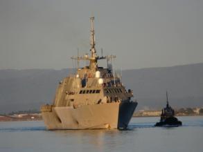
1 Humboldt Bay s Harbor Humboldt Bay is the second largest natural bay in California The only deep water harbor along ~400 miles of coast between San Francisco, CA and Coos Bay, OR One of only 11 deep water harbors in CA Harbor activity limited to the portion of Humboldt Bay from the Samoa Bridge to the end of the Fields Landing Channel


2 Humboldt Bay Water Use Designations 1. Principal: Primary designation areas within which either harbor-related or conservation uses are generally compatible with the Plan: Bay Conservation Harbor 2. Combining: Smaller designation areas within which additional, more specialized uses are generally accepted as compatible with the Plan: Marine Recreation Mariculture

3 Note: The County of Humboldt s authority extends over the entire bay area through their Humboldt Area Plan. The Harbor District has regulatory authority over the bay up to Mean Higher High Water tidal datum
 Approximately 1,000 acres of properlyzoned, underutilized coastal-dependent industrial property throughout the harbor portion of")
4 Humboldt Bay IS an active harbor Humboldt s harbor has: Deep water channels Underutilized waterdependent property 7 underutilized shipping docks Skilled workforce Tax incentives Necessary transportation links exist (although some are inactive) Approximately 1,000 acres of properlyzoned, underutilized coastal-dependent industrial property throughout the harbor portion of Humboldt Bay

5 Humboldt Bay Navigation Channels HOODS Channel Length 9.9 miles Channel Depths Entrance 48 MLLW North Channels: -38 MLLW South Channel: -26 MLLW

6 Humboldt Bay Maximum Ship Size: 950 in length; 38 draft

7 Federal Channel Maintenance: $2.5 - $6 Million/Year


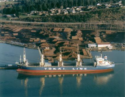
8 The Ports of Humboldt Bay 7 Marine Terminals - 6 Private - 1 Public Export: wood chips, logs Import: gas/diesel; wood chips
9 Local Revenue Generated Per Ship Call: $140K/Ship and Up Pilot invoices are approx $2,500-$10,000 Line service runs around $2,500 Pilot boat service runs between $15,000 to $25,000 per ship U S Customs fees call are approx $930 Other State/local gov't fees $800-$1000 Dockage fees $2,000-$2,500 per 24 hr period Wharfage, between $4 - $15 per metric ton of cargo Longshore wages on a "typical" vessel - $35,000- $45,000 depending on tonnage loaded and amount of overtime worked versus straight time Vessel's crewmembers shop in our local community as well. Some of this activity can exceed $1,000 per person In addition, some vessels purchase groceries here which can total several hundred dollars depending on the crew size


10 Commercial Fishing ~ 120 Registered Vessels 1 processing plant 3 Fish Buyers In Humboldt Bay Herring, Perch, Anchovies Offshore Crab, Salmon, Ground Fish, Albacore, Hagfish, Rock Fish, ocean Shrimp ~14 Million Pounds of Fish Landed/Year ~Ex-Vessel Value $10 Million/Year ~220 Commercial Vessels Registered in County

11 Recreational Boating/Tourism 4 Public Boat Launch Facilities (all boats) Samoa Bridge; Eureka Public Marina; Fields Landing; Fairhaven ~7,200 Recreational Vessels Registered in County


12 Recreational Boating/Tourism 6 Official Paddlecraft Launch Areas Woodley Island Marina; Hookton Slough; Arcata Marsh; Target; Adorni Center; Humboldt Bay Rowing

13 Recreational Boating/Tourism Visiting Yachts Museum Ships Special Events


14 Commercial Fishing and Recreational Boating Support Marinas 2 Public Marinas Woodley Island Marina: 234 slips City of Eureka: 134 slips 2 Private Marinas EZ Landing/Johnny s


15 Mariculture 325 Acres Cultured (4,000 Acres Certified by Department of Public Health) 56 Jobs Total Sales = $6 Million Payroll = $1.4 Million Arcata Oysterfest = $750,000 Annually Kumamoto Oyster Culture (Crassostrea sikamea) Long-line Culture (Crassostrea
16 Estimated Potential For Increased Economic Growth by Sector (2011 Baseline) Deep water shipping >$50 Million/Year - ~3,000 jobs* Shallow water shipping >$2 Million/Year - ~20 jobs Commercial fishing: Slight Increase Mariculture: > $4.6 Million/Year - ~40 jobs Recreation: Static Tourism: Static * Economic modeling has shown that Humboldt Bay s harbor has capacity for up to 10x its current level of activity. 5 million tons/year modeled 0.4 million tons shipped in 2013
HARBOR INFRASTRUCTURE INVENTORIES Marquette Harbor, Michigan
 HARBOR INFRASTRUCTURE INVENTORIES Marquette Harbor, Michigan Harbor Location: Marquette Harbor is located in Marquette Bay on the south shore of Lake Superior, 160 miles west of Sault Ste. Marie, MI and
Appendix G Coastal Demographic and Economic Trends Additional Figures
 Appendix G Coastal Demographic and Economic Trends Additional Figures Figure 1. Unemployment Rate in 1970-2004 18.0 16.0 14.0 12.0 10.0 8.0 6.0 4.0 1970 1972 1974 1976 1978 1980 1982 1984 1986 1988 1990
Coastal Harbors and Waterways, NC (Shallow Draft Navigation) (O&M)
 (O&M)") Coastal Harbors and Waterways, NC (Shallow Draft Navigation) (O&M) Shallow draft coastal harbors include a subsistence harbor at Silver Lake CONGRESSIONAL DISTRICT: NC 3, 7 DATE: 23 April 2018 1. AUTHORIZATION:
Coastal Harbors and Waterways, NC (Shallow Draft Navigation) (O&M) Shallow draft coastal harbors include a subsistence harbor at Silver Lake CONGRESSIONAL DISTRICT: NC 3, 7 DATE: 23 April 2018 1. AUTHORIZATION:
Coastal Harbors and Waterways, NC (Shallow Draft Navigation) (O&M)
 (O&M)") Coastal Harbors and Waterways, NC (Shallow Draft Navigation) (O&M) Shallow draft coastal harbors include a subsistence harbor at Silver Lake CONGRESSIONAL DISTRICT: NC 3 and 7 DATE: 23 February 2015 1.
Coastal Harbors and Waterways, NC (Shallow Draft Navigation) (O&M) Shallow draft coastal harbors include a subsistence harbor at Silver Lake CONGRESSIONAL DISTRICT: NC 3 and 7 DATE: 23 February 2015 1.
Marine Recreational and Commercial Industries and Activities in Lee and Charlotte Counties: Economic Consequences and Impacts
 Marine Recreational and Commercial Industries and Activities in Lee and Charlotte Counties: Economic Consequences and Impacts Betty Staugler Florida Sea Grant Extension Marine Agent & Chuck Adams Florida
Coastal Harbors and Waterways, NC (Shallow Draft Navigation) (O&M)
 (O&M)") Coastal Harbors and Waterways, NC (Shallow Draft Navigation) (O&M) Shallow draft coastal harbors include a subsistence harbor at Silver Lake CONGRESSIONAL DISTRICT: NC 3 and 7 DATE: 23 February 2015 1.
Coastal Harbors and Waterways, NC (Shallow Draft Navigation) (O&M) Shallow draft coastal harbors include a subsistence harbor at Silver Lake CONGRESSIONAL DISTRICT: NC 3 and 7 DATE: 23 February 2015 1.
HARBOR INFRASTRUCTURE INVENTORIES Port Sanilac Harbor, Michigan
 HARBOR INFRASTRUCTURE INVENTORIES Port Sanilac Harbor, Michigan Harbor Location: Port Sanilac Harbor is located on the west shore of Lake Huron, about 30 miles north of Port Huron, MI. Authority: Rivers
HARBOR INFRASTRUCTURE INVENTORIES Oak Orchard Harbor, New York
 HARBOR INFRASTRUCTURE INVENTORIES Oak Orchard Harbor, New York Harbor Location: Oak Orchard Harbor is located on the southern shore of Lake Ontario at the mouth of Oak Orchard Creek in the village of Point
HARBOR INFRASTRUCTURE INVENTORIES Caseville Harbor, Michigan
 HARBOR INFRASTRUCTURE INVENTORIES Caseville Harbor, Michigan Harbor Location: Caseville Harbor is located at the mouth of the Pigeon River on the east shore of Saginaw Bay, about 17 miles southwest of
Port Infrastructure to Support Floating Offshore Wind West Coast USA
 Port Infrastructure to Support Floating Offshore Wind West Coast USA Focus on California Figure: Principle Power Aaron Porter, P.E., & Shane Phillips, P.E. Mott MacDonald Seattle, WA BOEM Project Manager:
The Economic Impacts of Carolina Beach Inlet Navigability
 The Economic s of Carolina Beach Inlet Navigability June 27, 2014 By: Chris Dumas, Ph.D. Department of Economics and Finance Cameron School of Business UNC-Wilmington 601 South College Road Wilmington,
Report to the Monterey County Office of Economic Development. Caroline Pomeroy, Ph.D. 1. and. Michael Dalton, Ph.D. 2. June 2003
 SOCIO-ECONOMICS OF THE MOSS LANDING COMMERCIAL FISHING INDUSTRY Report to the Monterey County Office of Economic Development Caroline Pomeroy, Ph.D. 1 and Michael Dalton, Ph.D. 2 June 2003 1 Institute
HARBOR INFRASTRUCTURE INVENTORIES Fairport Harbor, OH
 HARBOR INFRASTRUCTURE INVENTORIES Fairport Harbor, OH Harbor Location: Fairport Harbor is located at the mouth of the Grand River on the southern shore of Lake Erie in the city of Fairport, OH, approximately
HARBOR INFRASTRUCTURE INVENTORIES Cheboygan Harbor, Michigan
 HARBOR INFRASTRUCTURE INVENTORIES Cheboygan Harbor, Michigan Harbor Location: Cheboygan Harbor is located at the mouth of the Cheboygan River, emptying into western Lake Huron approximately 16 miles southeast
DESCRIPTION OF THE AFFECTED ENVIRONMENT (KEY SOCIO-ECONOMIC TRENDS) AND SUPPLEMENTAL ANALYSIS OF THE ALTERNATIVES
 AND SUPPLEMENTAL ANALYSIS OF THE ALTERNATIVES") Agenda Item D..a Supplemental Attachment June 01 DESCRIPTION OF THE AFFECTED ENVIRONMENT (KEY SOCIO-ECONOMIC TRENDS) AND SUPPLEMENTAL ANALYSIS OF THE ALTERNATIVES The following discussion provides information
Agenda Item D..a Supplemental Attachment June 01 DESCRIPTION OF THE AFFECTED ENVIRONMENT (KEY SOCIO-ECONOMIC TRENDS) AND SUPPLEMENTAL ANALYSIS OF THE ALTERNATIVES The following discussion provides information
Superyacht Seattle. Moorage Options
 Superyacht Seattle Moorage Options Terminal91 Terminal 91 2001 W Garfield St Seattle, WA 98199 206.787.3751 seaops@portseattle.org Terminal 91 is a secure facility located on Elliott Bay, at the north
California Management of Forage Fish Species. Deb Wilson- Vandenberg Senior Environmental Scientist California Department of Fish and Game
 California Management of Forage Fish Species Deb Wilson- Vandenberg Senior Environmental Scientist California Department of Fish and Game Overview Ø State Management Authorities Ø Major forage species
Observing and Explaining Coastal Fishery Dynamics : An Application to Ports in California
 Observing and Explaining Coastal Fishery Dynamics : An Application to Ports in California Cameron Speir, NMFS Caroline Pomeroy, California Sea Grant Jon G. Sutinen, University of Rhode Island Cynthia J.
HARBOR INFRASTRUCTURE INVENTORIES Lexington Harbor, Michigan
 HARBOR INFRASTRUCTURE INVENTORIES Lexington Harbor, Michigan Harbor Location: Lexington Harbor is located on the west shore of Lake Huron about 20 miles north of Port Huron, MI. Authority: Rivers & Harbors
HARBOR INFRASTRUCTURE INVENTORIES Muskegon Harbor, Michigan
 HARBOR INFRASTRUCTURE INVENTORIES Muskegon Harbor, Michigan Harbor Location: Muskegon Harbor is located on the east shore of Lake Michigan, 114 miles northeast of Chicago, IL. Authority: River & Harbor
Redondo Beach Boat Launch Ramp Facility
 Redondo Beach Boat Launch Ramp Facility Feasibility Report for the California Department of Boating and Waterways 2015 Grant Cycle For the City of Redondo Beach Submitted by March 13, 2014 Table of Contents
Wexford Harbour. Yachting Guide. Navigation
 Wexford Harbour Yachting Guide Navigation This document supersedes all previous editions. Approvals: Yacht Club Committee April, 2015 Wexford Board of Directors April, 2015 # Date Section Revision 1 6.5.2015
HARBOR INFRASTRUCTURE INVENTORIES West Harbor, OH
 HARBOR INFRASTRUCTURE INVENTORIES West Harbor, OH Harbor Location: West Harbor is located on the southern shore of Lake Erie in the township of Catawba Island, OH about 50 miles east of Toledo, OH. Authority:
Warm-up # 7 A day 5/17 - B day 5/18 UPDATE YOUR TABLE OF CONTENTS
 Warm-up # 7 A day 5/17 - B day 5/18 UPDATE YOUR TABLE OF CONTENTS Question: List all examples of surface water on Earth. Answer: Rivers and streams, lakes and reservoirs, (ponds) wetlands, estuaries and
HARBOR INFRASTRUCTURE INVENTORIES Kenosha Harbor, Wisconsin
 HARBOR INFRASTRUCTURE INVENTORIES Kenosha Harbor, Wisconsin Harbor Location: Kenosha Harbor is on the west shore of Lake Michigan about 54 miles north of Chicago, Illinois. Authority: River & Harbor Acts
CONSERVATION AND MANAGEMENT OF COASTAL WETLANDS IN CALIFORNIA
 Studies in Avian Biology No. 2: 151-155, 1979. CONSERVATION AND MANAGEMENT OF COASTAL WETLANDS IN CALIFORNIA JOHN SPETH' The title, Conservation and Management of Coastal Wetlands in California, implies
HARBOR INFRASTRUCTURE INVENTORIES Black Rock Lock & Tonawanda Harbor, NY
 HARBOR INFRASTRUCTURE INVENTORIES Black Rock Lock & Tonawanda Harbor, NY Harbor Location: The Black Rock Channel and Tonawanda Harbor are located along the east side of the Niagara River in the City of
Norwalk Harbor: The Jewel of Long Island Sound. A Presentation by the Norwalk Harbor Management Commission
 Norwalk Harbor: The Jewel of Long Island Sound A Presentation by the Norwalk Harbor Management Commission 2018 State of the Harbor Meeting December 13, 2018 The City of Norwalk in Southwest Connecticut
WEST COAST FISHERIES AND MANAGEMENT
 WEST COAST FISHERIES AND MANAGEMENT Olympic Coast National Marine Sanctuary Advisory Council May 20, 2016 Heather Reed - WDFW Jessi Doerpinghaus - WDFW FISHING IS KEY TO WASHINGTON S ECONOMY Washington
California s North Coast Fishing Communities Historical Perspective and Recent Trends. Project Summary
 California s North Coast Fishing Communities Historical Perspective and Recent Trends Project Summary Caroline Pomeroy, Cynthia J. Thomson, Melissa M. Stevens Published by California Sea Grant College
2.6 Dry Bulk, Break-Bulk, and Yachts and Vehicles Cargo Market Assessment
 2.6 Dry, Break-, and Yachts and Vehicles Cargo Market Assessment 2.6.1 Forecast Summary Annual cargo demand for dry bulk, break-bulk, yachts and vehicles was forecast under three scenarios (see Figure
1-32 NOME HARBOR, ALASKA (CWIS NOS , 87755, & 10422) Condition of Improvement 30 September 2009
 Condition of Improvement 30 September 2009") NOME HARBOR 1-32 NOME HARBOR, ALASKA (CWIS NOS. 72742, 87755, & 10422) Condition of Improvement 30 September 2009 AUTHORIZATION: (1) Rivers and Harbors Act, 8 August 1917 (House Doc. 1932, 64th Congress,
NOME HARBOR 1-32 NOME HARBOR, ALASKA (CWIS NOS. 72742, 87755, & 10422) Condition of Improvement 30 September 2009 AUTHORIZATION: (1) Rivers and Harbors Act, 8 August 1917 (House Doc. 1932, 64th Congress,
RESEARCH Massachusetts Recreational Boater Survey. Project Summary
 Coastal and Marine Spatial Planning RESEARCH Project Summary 2010 Massachusetts Recreational Boater Survey The 2010 Massachusetts Recreational Boater Survey gathered spatial and economic data relating
California s North Coast Fishing Communities Historical Perspective and Recent Trends
 California s North Coast Fishing Communities Historical Perspective and Recent Trends Appendix C: Methodological Detail Customization of PacFIN Landings Receipt Data to Characterize Commercial Fisheries
31 Several of these communities
 5. Port Profiles In this section we present trends in landings, revenues, fishery participation, and other characteristics of local fisheries for the main ports and port groups in the study area: 1. Bodega
Seafood Industry. The 2012 Juneau and Southeast Alaska Economic Indicators 11/1/12 Page 60
 Seafood Industry In 2011, fishermen in Southeast landed 395,628,268 pounds of fish with an ex vessel value of $391,091,684. This harvest resulted in 272.6 million pounds of product, with a wholesale value
CORPS ON THE COAST. North Carolina Coastal Conference Coastal Infrastructure Raleigh, NC April 14, Jim Medlock Chief, Programs Management Branch
 CORPS ON THE COAST North Carolina Coastal Conference Coastal Infrastructure Raleigh, NC April 14, 2015 Jim Medlock Chief, Programs Management Branch US Army Corps of Engineers OVERVIEW What Are The Corps
State of Texas Operations and Maintenance
 State of Texas Operations and Maintenance Barbour Terminal Ship Channel The Barbour Terminal Channel and Turning Basin is a 1.7-mile-long deep draft waterway that extends from the Houston Ship Channel
Commercial Net Pen Salmon Farming in Washington State
 Commercial Net Pen Salmon Farming in Washington State Icicle SeafoodsOverivew at a glance Icicle Seafoods Icicle is a leading harvester, producer and processor of diversified seafood products in North
California s North Coast Fishing Communities Historical Perspective and Recent Trends. Eureka Fishing Community Profile
 California s North Coast Fishing Communities Historical Perspective and Recent Trends Eureka Fishing Community Profile Caroline Pomeroy, Cynthia J. Thomson, Melissa M. Stevens Published by California Sea
Memorandum. To: City Council. cc: Tony Piasecki, City Manager Date: 3/3/2016. Introduction
 I Memorandum 211 To: City Council From: Joe Dusenbury, Harbormaster cc: Tony Piasecki, City Manager Date: 3/3/2016 Re: City Government 101 -The Marina Introduction Staff is presenting this material as
HARBOR INFRASTRUCTURE INVENTORIES Lorain Harbor, Ohio
 HARBOR INFRASTRUCTURE INVENTORIES Lorain Harbor, Ohio Harbor Location: Lorain Harbor is located on the southern shore of Lake Erie in the city of Lorain, OH about 45 miles west of Cleveland, OH. Authority:
CALIFORNIA DEPARTMENT OF FISH AND WILDLIFE UPDATE ON LANDINGS OF TUNA, SWORDFISH AND OTHER PELAGICS
 Agenda Item I.2.a Supplemental CDFW Report November 216 CALIFORNIA DEPARTMENT OF FISH AND WILDLIFE UPDATE ON LANDINGS OF TUNA, SWORDFISH AND OTHER PELAGICS Update on Pacific Bluefin Tuna Commercial Landings
CALIFORNIA DEPARTMENT OF FISH AND WILDLIFE UPDATE ON LANDINGS OF TUNA, SWORDFISH AND OTHER PELAGICS
 Agenda Item H.2.c Supplemental CDFW Report 1 November 217 CALIFORNIA DEPARTMENT OF FISH AND WILDLIFE UPDATE ON LANDINGS OF TUNA, SWORDFISH AND OTHER PELAGICS CDFW Summary of HMS Landings Data Improvement
Coastal Hazards and Management in North Carolina. Braxton Davis April 14, 2015
 Coastal Hazards and Management in North Carolina Braxton Davis April 14, 2015 Coastal Facts and Figures 320 miles of ocean beaches 12,000+ miles of estuarine shoreline 2 million + acres of sounds, creeks,
Western Fishboat Owners Association (WFOA) Informational Report
 Informational Report") Agenda Item H.2.e Supplemental Public Comment March 2015 The entry of the Chinese fleet into Pacific Ocean tuna fisheries and the economic impact to the U.S. albacore fleet from this large subsidized and
Agenda Item H.2.e Supplemental Public Comment March 2015 The entry of the Chinese fleet into Pacific Ocean tuna fisheries and the economic impact to the U.S. albacore fleet from this large subsidized and
Eelgrass Survey PARADISE CAY BELVEDERE, MARIN COUNTY CALIFORNIA. Prepared For:
 Eelgrass Survey PARADISE CAY BELVEDERE, MARIN COUNTY CALIFORNIA Prepared For: Radford (Skid) Hall, Ph.D. Land Planning and Permitting Consultant 500 Airport Blvd., Suite 350 Burlingame, CA 94010 (650)
V. HARBOR DEPTHS, CHANNEL DESIGN AND PROPOSED CONSTRUCTION AND DREDGING
 V. HARBOR DEPTHS, CHANNEL DESIGN AND PROPOSED CONSTRUCTION AND DREDGING A. DISCUSSION: For the most part, projects that involve dredging and construction require a comprehensive design and review process
1-32 NOME HARBOR, ALASKA (CWIS NOS , 87755, 12270, & 10422) Condition of Improvement 30 September 2012
 Condition of Improvement 30 September 2012") NOME HARBOR 1-32 NOME HARBOR, ALASKA (CWIS NOS. 72742, 87755, 12270, & 10422) Condition of Improvement 30 September 2012 AUTHORIZATION: (1) Rivers and Harbors Act, 8 August 1917 (House Doc. 1932, 64th
NOME HARBOR 1-32 NOME HARBOR, ALASKA (CWIS NOS. 72742, 87755, 12270, & 10422) Condition of Improvement 30 September 2012 AUTHORIZATION: (1) Rivers and Harbors Act, 8 August 1917 (House Doc. 1932, 64th
ort of Ilwaco & Port of Chinook Washington Public Ports Association Port Report November 17, 2016 Guy Glenn, Manager
 ort of Ilwaco & Port of Chinook Washington Public Ports Association Port Report November 17, 2016 Guy Glenn, Manager Pacific & Grays Harbor Counties Public Port Marinas: Port of Grays Harbor Westport Port
The Nevada 1st Congressional District
 The Nevada st Area (square miles) Navigable Waterbody (square miles) Population (007) Population Density (per square mile) (007) Persons 8+ (007) Households (007) Table. Owned by Residents Residing in
GENTLEMEN SIT or GENTLEMEN CLEAN THE HEAD
 GENTLEMEN SIT or GENTLEMEN CLEAN THE HEAD NOTE: Joker valve has a ¾ in opening. Because of this it is EASY to plug. If you did not eat it do not put it in the head. NEVER RELEASE THE WHEEL WHEN UNDERWAY
Economic Impact Analysis BOONE DOCKS RESORT AND MARINA, LLC
 Economic Impact Analysis BOONE DOCKS RESORT AND MARINA, LLC Analysis conducted using the on-line Boating Economic Impact Model developed by Drs. Ed Mahoney (mahoneye@msu.edu), Dan Stynes (stynes@msu.edu)
Coastal and marine recreation in New England is ingrained in the region s economic and
 RECREATION Coastal and marine recreation in New England is ingrained in the region s economic and social fabric. Recreation on the ocean and coast includes many of New Englanders most time-honored and
BIG RIVER COALITION RED RIVER VALLEY ASSOCIATION Sean M. Duffy, Sr. Executive Director
 BIG RIVER COALITION RED RIVER VALLEY ASSOCIATION 22119 Sean M. Duffy, Sr. Executive Director sean.duffy@bigrivercoaltiion.org MARITIME NATION ENGINEER S WEEK 22217 MARITIME STATE MISSISSIPPI RIVER SHIP
HARBOR INFRASTRUCTURE INVENTORIES Harbor Beach Harbor, Michigan
 HARBOR INFRASTRUCTURE INVENTORIES Harbor Beach Harbor, Michigan Harbor Location: Harbor Beach Harbor is located on the west shore of Lake Huron about 60 miles north of Port Huron, MI. Authority: Rivers
SOCIETAL GOALS TO DETERMINE ECOSYSTEM HEALTH: A FISHERIES CASE STUDY IN GALVESTON BAY SYSTEM, TEXAS
 SOCIETAL GOALS TO DETERMINE ECOSYSTEM HEALTH: A FISHERIES CASE STUDY IN GALVESTON BAY SYSTEM, TEXAS Anthony S. Pait, NOAA, National Centers for Coastal Ocean Science Thomas P. O Connor, David R. Whitall,
Visiting Lake Macquarie
 Visiting Lake Macquarie Lake Macquarie is the largest coastal salt water lake in Australia and is a prime boating destination for both small and large vessels. Many sailing regattas and fishing activities
The LA/LB Harbors handle more than 5,500 commercial vessel arrivals per year (excluding local coastwise and Catalina Island traffic).
.") X. SMALL CRAFT For the purpose of the Los Angeles and Long Beach Harbor Safety Plan, pleasure vessels, commercial fishing vessels and sportfishing boats are designated as small craft. A. BACKGROUND: The
X. SMALL CRAFT For the purpose of the Los Angeles and Long Beach Harbor Safety Plan, pleasure vessels, commercial fishing vessels and sportfishing boats are designated as small craft. A. BACKGROUND: The
Agenda Item G.1.a Supplemental CDFW Report 2 September 2015
 Agenda Item G.1.a Supplemental CDFW Report 2 September 2015 CALIFORNIA DEPARTMENT OF FISH AND WILDLIFE REPORT ON PACIFIC BLUEFIN MONITORING AND MANAGEMENT ACTIVITIES FOR RECREATIONAL AND COMMERCIAL FISHERIES
To Fish or Not to Fish? A role-playing activity based on the Marine Reserves process at the Channel Islands National Marine Sanctuary
 To Fish or Not to Fish? A role-playing activity based on the Marine Reserves process at the Channel Islands National Marine Sanctuary Introduction This role playing activity is designed to teach you about
The Mid-Atlantic Recreational Boater Survey
 The Mid-Atlantic Recreational Boater Survey April 2016 Mid-Atlantic Recreational Boater Survey 1 CONTENTS 30TABOUT THE SPONSORS30T... 2 30TEXECUTIVE SUMMARY30T... 3 30TSURVEY OVERVIEW30T... 5 30TECONOMIC
9 This section relies heavily on
 2. Historical Perspective and Current Trends Fisheries have long played an important role in the economic, social, and cultural life of coastal communities in North-central California. 9 At the time of
California Department of Fish and Wildlife Report to the International Pacific Halibut Commission on 2017 California Fisheries
 IPHC-2018-AM094-AR08 Received: 22 December 2017 California Department of Fish and Wildlife Report to the International Pacific Halibut Commission on 2017 California Fisheries California Department of Fish
THE CARTERET COUNTY SHELLFISH FARMING PROGRAM A proposal to create jobs and encourage local small business ownership in the shellfish farming industry
 THE CARTERET COUNTY SHELLFISH FARMING PROGRAM A proposal to create jobs and encourage local small business ownership in the shellfish farming industry Dennis Litalien PURPOSE Provide background Generate
Nome Harbor Page 2 of 12
 Nome Harbor Nome Harbor Page 2 of 12 Condition of Improvements 30 December 2015 Nome Harbor, Alaska (CWIS No. 010422, 012270, 072742, 087755) Authorization (1) Rivers and Harbors Act, 8 August 1917 (House
APPENDIX D-2. Sea Level Rise Technical Memo
 APPENDIX D-2 Sea Level Rise Technical Memo 2185 N. California Blvd., Suite 500 Walnut Creek, CA 94596 (925) 944-5411 Fax: (925) 944-4732 www.moffattnichol.com DRAFT MEMORANDUM To: From: Neil Nichols,
Background on. Oregon's COOPERATIVE EXTENSION SERVICE OREGON STATE UNIVERSITY. Extension Circular 750 August 1970
 Background on Oregon's D COOPERATIVE EXTENSION SERVICE OREGON STATE UNIVERSITY Extension Circular 750 August 1970 BACKGROUND ON OREGON'S MARINE INDUSTRY Robert O. Coppedge and Frederick J. Smith Extension
Coastal Community Perspectives on Off-Shore Energy Development
 Coastal Community Perspectives on Off-Shore Energy Development Kaety Hildenbrand Marine Fisheries Extension Faculty Oregon Sea Grant Extension Oregon State University Coastal Communities of Place and Interest
East Central Florida Region Matt Culver, Brevard County James Gray, Indian River County Jim Oppenbourn, St. Lucie County Kathy Fitzpatrick, Martin
 James Gray, Indian River County January 14, 2015 East Central Florida Region Matt Culver, Brevard County James Gray, Indian River County Jim Oppenbourn, St. Lucie County Kathy Fitzpatrick, Martin County
 1 of 3 11/21/2013 3:25 PM Pilotage for Crossing the Outer Bar of Mobile Bay or Navigating a Vessel into or out of the Bay or Harbor of Mobile Effective January 1, 2009 Gross tonnage charge: Effective 05/01/13
Appendix H Recreation and Tourism (Chapter 8) Contents. List of Tables
 Contents. List of Tables") Appendix H Recreation and Tourism (Chapter 8) Contents Trends Data... H-2 CA DMV records... H-2 CA DFG Hunting/Fishing Licenses... H-2 USDA Agricultural Tourism... H-4 United States Forest Service... H-6
Appendix H Recreation and Tourism (Chapter 8) Contents Trends Data... H-2 CA DMV records... H-2 CA DFG Hunting/Fishing Licenses... H-2 USDA Agricultural Tourism... H-4 United States Forest Service... H-6
Leaning Into Adaptation
 www.marinslr.org Leaning Into Adaptation GFNMS Ocean Summit, May 17, 2016 Jack Liebster, Planning Manager, Marin County Marin County C-SMART Sea Level Rise Adaptation Process Evaluate Science Info. Implement
Texas Department of Transportation s Gulf Intracoastal Waterway Capacity Study. GICA 112 th Annual Seminar July 28, 2017
 Texas Department of Transportation s Gulf Intracoastal Waterway Capacity Study GICA 112 th Annual Seminar July 28, 2017 Study Purpose Determine if current levels of vessel activity on the Texas segment
APPENDIX M DREDGED MATERIAL MANAGEMENT PLAN (DMMP) FINAL INTEGRATED FEASIBILITY REPORT AND ENVIRONMENTAL ASSESSMENT
 FINAL INTEGRATED FEASIBILITY REPORT AND ENVIRONMENTAL ASSESSMENT") APPENDIX M DREDGED MATERIAL MANAGEMENT PLAN (DMMP) Brazos Island Harbor, Texas Channel Improvement Study FINAL INTEGRATED FEASIBILITY REPORT AND ENVIRONMENTAL ASSESSMENT This page is intentionally left
APPENDIX M DREDGED MATERIAL MANAGEMENT PLAN (DMMP) Brazos Island Harbor, Texas Channel Improvement Study FINAL INTEGRATED FEASIBILITY REPORT AND ENVIRONMENTAL ASSESSMENT This page is intentionally left
DRAFT. October 17, 2014 File No Mr. Brendhan Zubricki Town Administrator Essex Town Hall 30 Martin Street Essex, MA.
 GZA GeoEnvironmental, Inc. Engineers and Scientists October 17, 2014 File No. 18.0171857.00 Mr. Brendhan Zubricki Town Administrator Essex Town Hall 30 Martin Street Essex, MA. 01929 DRAFT Re: Essex River
Socioeconomic Profile and Spatial Analysis of Fisheries in the three central California National Marine Sanctuaries
 Socioeconomic Profile and Spatial Analysis of Fisheries in the three central California National Marine Sanctuaries Overview and Assessment of CDFG Fisheries Data for use in the Joint Management Plan Review
Juneau Douglas Harbor
 Juneau Douglas Harbor Douglas Harbor Page 2 of 8 Condition of Improvements 31 December 2015 Douglas Harbor, Alaska (CWIS No. 072789, 180942) Authorization Rivers and Harbors Act, 3 July 1958 (House Doc.
Fort Hancock Sailing Center
 Response to the National Parks Service Request for Expressions of Interest to Redevelop Historic Structures at Fort Hancock in the Sandy Hook Unit of Gateway National Recreation Area Fort Hancock Sailing
APPENDIX D REAL ESTATE PLAN
 NAVIGATION IMPROVEMENTS SITKA HARBOR, ALASKA CHANNEL ROCK BREAKWATERS DRAFT DEFICIENCY CORRECTION EVALUATION REPORT APPENDIX D REAL ESTATE PLAN JANUARY 2011 REAL ESTATE PLAN FOR SITKA HARBOR, ALASKA CHANNEL
Developing the Best Freshwater Fisheries in North America. Adrian Clarke BCWF AGM and Convention April 23, 2016
 Developing the Best Freshwater Fisheries in North America Adrian Clarke BCWF AGM and Convention April 23, 2016 1. Who we are 2. What your licence dollars are funding and Why 3. How can we make fishing
For each benefit category listed above, several measures of economic benefits were calculated:
 EXECUTIVE SUMMARY The objective of this study was to examine the economic benefits of Oregon Inlet navigability to Dare County, North Carolina and the surrounding region, including northeastern North Carolina
Attachment A. Pertinent Correspondence
 Attachment A Pertinent Correspondence GREAT CHEBEAGUE ISLAND INITIAL APPRAISAL REPORT SPONSOR-PROVIDED DATA To: Army Corp. of Engineers From: Ronald Tozier: Harbor Master; Town of Chebeague Island
Recreational Boating Feasibility and Capacity Study
 TOURISTICS + Shoreplan Engineering Limited were retained by: Town of Oakville; City of Burlington; and Regional Municipality of Halton. Note: Throughout the presentation boat lengths are identified in
BookletChart. Chesapeake Bay Tangier Sound, Northern Part NOAA Chart A reduced-scale NOAA nautical chart for small boaters
 BookletChart Chesapeake Bay Tangier Sound, Northern Part NOAA Chart 12231 A reduced-scale NOAA nautical chart for small boaters When possible, use the full-size NOAA chart for navigation. Published by
SAILING INSTRUCTIONS BILLY RUN. Saturday 28 April The organising authority (OA) is the South of Perth Yacht Club
 is the South of Perth Yacht Club") SAILING INSTRUCTIONS BILLY RUN Saturday 28 April 2018 The organising authority (OA) is the South of Perth Yacht Club 1. RULES 1.1. The regatta will be governed by the rules as defined in The Racing Rules
SAILING INSTRUCTIONS BILLY RUN Saturday 28 April 2018 The organising authority (OA) is the South of Perth Yacht Club 1. RULES 1.1. The regatta will be governed by the rules as defined in The Racing Rules
Monitoring of European Green Crabs, Carcinus maenas, in Humboldt Bay, California 2012 Summary Report. prepared by
 Monitoring of European Green Crabs, Carcinus maenas, in Humboldt Bay, California 2012 Summary Report prepared by Kirsten Ramey Environmental Scientist Aquaculture and Bay Management Project California
CORPS FACTS. Harbor Dredging U.S. ARMY CORPS OF ENGINEERS BUILDING STRONG
 CORPS FACTS Harbor Dredging U.S. ARMY CORPS OF ENGINEERS BUILDING STRONG Disaster Response Sedimentation in the channel is caused by the normal cycle of silt movement, erosion from high water or heavy
A Threatened Bay: Challenges to the Future of the Penobscot Bay Region and its Communities
 A Threatened Bay: Challenges to the Future of the Penobscot Bay Region and its Communities 1 A A Threatened Bay: Challenges to the Future of the Penobscot Bay Region and its Communities In 1996 the Island
Pacific Coast Congress of Harbor Master & Port Managers
 Pacific Coast Congress of Harbor Master & Port Managers Getting It Done The Crescent City Harbor has a long history of damage and destruc7on from tsunamis. The city experienced tsunami condi7ons 31 7mes
LONG BEACH TO DANA POINT RACE. 34 th Annual Labor Day Race Saturday, September 2, 2017 NOTICE OF RACE
 LONG BEACH TO DANA POINT RACE 34 th Annual Labor Day Race Saturday, September 2, 2017 NOTICE OF RACE ORGANIZING AUTHORITY & MANAGEMENT The organizing authority for this Race is Shoreline Yacht Club (SYC),
Economic Impact of Lobster Sector - Province of New Brunswick and Its Counties
 Economic Impact of Lobster Sector - Province of New Brunswick and Its Counties Pierre-Marcel Desjardins Economist February 2007 Introduction This assessment seeks to quantify the economic impact of the
Recreational Boating Industry
 Recreational Boating Industry Powering the Canadian Economy 2017 policy agenda 2 Table of Contents A Note from NMMA Canada s Executive Director A Note from NMMA Canada s Executive Director...3 What is
Sport Fishing Expenditures and Economic Impacts on Public Lands in Oregon
 Sport Fishing Expenditures and Economic Impacts on Public Lands in Oregon For: Northwest Sportfishing Industry Association By: Southwick Associates October 2013 PO Box 6435 Fernandina Beach, FL32035 Tel
OR DUNGENESS CRAB FISHERY:
 E 55 OR DUNGENESS CRAB FISHERY: an economic analysis of productivity and profitability David S. Liao Joe B. Stevens OREGON STATE UNIVERSITY SEA GRANT COLLEGE PROGRAM Publication no. ORESU-T-75-005 AGRICULTURAL
Oregon Commercial Fishing Industry Year 2016 Economic Activity Summary Version 1.5, April Abstract
 Oregon Commercial Fishing Industry Year 2016 Economic Activity Summary Version 1.5, April 2017 Abstract The Oregon commercial fishing industry generated an estimated $544 million household income in 2016.
Green Sturgeon Feeding Observations in Humboldt Bay, California
 Green Sturgeon Feeding Observations in Humboldt Bay, California Matt Goldsworthy 1, Bill Pinnix, Miles Barker 1, Liz Perkins 1, Aaron David, Jeffrey Jahn 1 Introduction Understanding the distribution,
Maltester Channel Dredging. Shoreline Marina Committee. November 18, 2008
 Maltester Channel Dredging Shoreline Marina Committee November 18, 2008 Shoaling Study Summary Report Completed in October 2008 Analyzed siltation rates at Marina Rate of siltation is dynamic ranging from
VESSEL TRANSIT SCHEDULING AT THE PANAMA CANAL NUMBER AND ORDER OF VESSELS IN THE SCHEDULE
 VESSEL TRANSIT SCHEDULING AT THE PANAMA CANAL This document intends to provide our clients with a better understanding of vessel scheduling in the Panama Canal. For any questions not addressed in this
PROCEDURES ON ARRIVAL AT RICHARDS BAY
 PROCEDURES ON ARRIVAL AT RICHARDS BAY INTERNATIONAL ARRIVALS Call Port Control on CHANNEL 12 to request permission to enter harbor Please note this is very important, Port Control will not respond to any