IF YOU BUILD IT THEY WILL COME
|
|
|
- Brianne Cain
- 6 years ago
- Views:
Transcription


1 IF YOU BUILD IT THEY WILL COME Delaware s Artificial Reef Program is funded under the Federal Aid in Fisheries Restoration Act by the Delaware Division of Fish and Wildlife
2 ABOUT THE COVER The tugs Fels Point, Cittie Point and W.C. Snow are photographed in tow to their final resting place on site #11 June 2, The Dominion Marine Group tug American was the platform for the photographer. ABOUT THE REEF GUIDE Welcome to the Recession Edition of the Delaware Reef Guide, printed in black and white to conserve funding for reef development activities is expected to be a good year for the Reef Program. The Navy has awarded the retired destroyer, Arthur W. Radford to the Delaware, New Jersey and Maryland Reef Program for a cooperative effort to sink it on a Delaware permitted reef site. We expect to select a contractor and resume the deployment of concrete materials on Delaware Bays sites. A new reef site near Augustine Beach is expected to receive its first reef Materials and New York city subways cars continue to be deployed on ocean sites. Enjoy fishing Delaware s Reefs!
3 THE DELAWARE REEF PROGRAM Delaware has fourteen permitted artificial reef sites in Delaware Bay and along the Atlantic Coast. Development of these sites began in 1995 and will continue in the future. The Delaware Reef Program is one part of a comprehensive fisheries management effort and is designed to enhance fisheries habitat, benefit structure-oriented fish and provide fishing opportunities for anglers Reef construction is especially important in the Mid-Atlantic Region, where near shore bottom is usually featureless sand or mud. We have neither the natural rocky outcrops common in New England nor the coral reefs of our Southeastern Atlantic Coast. Durable, stable, nontoxic reef materials can develop an invertebrate community which is hundreds of times richer than adjacent bottom, providing food and physical protection for reef fish such as tautog, sea bass, scup, spadefish and triggerfish. In addition, game fish such as flounder, bluefish, striped bass, weakfish, tunas and sharks are attracted to baitfish, which congregate around reef structure. Recycled materials have supported reef development efforts to date. Donated concrete culvert pipe and other concrete products are the primary materials used at the eight Delaware Bay sites. Ballasted tire units have been deployed at the three ocean sites. To date, over 74,000 tons of concrete products, 9,000 tons of ballasted tire units and 86 decommissioned military vehicles. Retired vessels have become an important part of the Reef Program in recent years with 17 vessels from sunk on 7 reef sites. An additional three vessels and six barges are under contract for sinking in The reef program uses DGPS (Differential Global Positioning System) to accurately place materials on site. The site charts in the reef guide show where reef materials have been deployed from Locations (latitude longitude) noted for each site indicate the position of deployments of reef material from an anchored barge. In the case of large, concentrated reef deployments, a latitude or longitude range, may be given such as: N This indicates material occurs between 39 degrees, to minutes north latitude. Due to variability between DGPS receivers, slight variation in readings may occur. It is suggested you use your GPS and a good fathometer to locate reef structure, then note the coordinates on your own GPS.

4 GENERAL LOCATION OF DELAWARE S FOURTEEN PERMITTED ARTIFICIAL REEF SITES
5 Site #1 Total area of site square nautical miles Depth range (mean low water) Distance from port nautical miles from Port Mahon Invertebrate Colonization - oyster, barnacle, hydroid community Fish - sea bass plus pelagic species (weakfish, striped bass) Deployments tons of concrete culvert deployed from an anchored barge 3/28/96. Depth about 30. N W tons of concrete culvert deployed from an anchored barge 9/15/98. Depth about 29. N W ,690 tons of concrete culvert deployed from an anchored barge 1/09/03. N W tons of concrete culvert deployed from an anchored barge 7/3/04. N W ,582 tons of concrete culvert deployed from and anchored barge 7/10/04. N W steel hull pilot boat N W Notes
6
7 Site #2 Total are of site square nautical miles Depth range (mean low water) Distance from port nautical miles from Port Mahon Invertebrate Colonization - oyster, barnacle, hydroid community Fish - sea bass plus pelagic species (weakfish, striped bass) Deployments tons of concrete culvert deployed 3/28/96. Depth about 22. N W tons of concrete culvert deployed 9/15/98. Depth 26. N W tons of concrete culvert deployed 6/20/00. Depth N W ,100 tons of concrete culvert deployed 5/11/02. Depth 28. N W ,000 tons of concrete culvert deployed 12/23/02. Depth 28. N W ,610 tons of concrete culvert deployed 11/07/03. N W Notes
8
9 Site #3 Total area of site square nautical miles Depth range (mean low water) Distance from port nautical miles from Bowers Beach 6.0 nautical miles from Mispillion River Invertebrate Colonization - blue mussel, sulfur sponge community Fish - sea bass, weakfish, striped bass, bluefish tons of concrete culvert deployed 1/15/96. Deployments 2. 1,000 tons of concrete culvert deployed from an anchored barge 5/14/97. Water depth about 32. N W tons of concrete culvert deployed 6/1/00. Depth 30. N W tons of concrete culvert deployed 7/7/00. Depth 34. N W ,300 tons of concrete deployed 7/15 / 01. N W ,000 tons of concrete deployed 6/10/02. Depth 28. N W ,092 tons of concrete deployed 4/14/03. Depth 26. N W ,590 tons of concrete deployed 3/11/04. Depth 26. N W Notes
10
11 Site #4 Total area of site square nautical miles Depth range (mean low water) Distance from port - 6 nautical miles from Bowers Beach 7 nautical miles from Mispillion River Invertebrate Colonization - blue mussel community Fish - sea bass, weakfish, striped bass, tautog Deployments tons of concrete culvert deployed from a moving barge tons of concrete culvert deployed from an anchored barge on 2/12/97. Depth about 38. N W ,000 tons of concrete deployed on 10/2/97. Approximate depth 35. N W ,100 tons of concrete deployed on 3/21/99. Depth 37. N W tons of concrete deployed on 4/8/99. Depth 42. N W ,192 tons of concrete deployed 3/28/03. Depth 38. N W ,511 tons of concrete deployed 7/7/04. N W ,407 tons of concrete deployed 11/02/05. Depth 34. N W Notes
12
13 Site #5 Total area of site square nautical miles Depth range (mean low water) Distance from port nautical miles from Mispillion River 8.5 nautical miles from Roosevelt Inlet Invertebrate Colonization - blue mussel, sulfur sponge community Fish - sea bass, tautog, scup, weakfish Deployments large rectangular concrete structures deployed from a moving barge 7/6/95. Depth about ,000 tons of concrete culvert deployed on 8/17/97. Approximate depth 25. N W tons of concrete culvert deployed on 7/12/00. Depth 26. N W ,100 tons of concrete deployed on 6/11/01. N W ,300 tons of concrete deployed on 8/10/01. N W ,098 tons of concrete deployed on 7/29/02. N W ,087 tons of concrete deployed on 12/29/02. N W ,085 tons of concrete deployed on 4/25/03. N W ,588 tons of concrete deployed on 8/24/04. N W ,100 tons of concrete deployed 3/30/06. N W Notes
14
15 Site #6 Total area of site square nautical miles Depth range (mean low water) Distance from port - 7 nautical miles from Mispillion River 10 nautical miles from Roosevelt Inlet Invertebrate Colonization - blue mussel community Fish - sea bass, tautog, scup, weakfish, striped bass, bluefish Deployments tons concrete culvert deployed from a moving barge - 10/20/ tons concrete culvert deployed from an anchored barge - 6/21/96. N W tons of concrete deployed from an anchored barge 9/25/99. Depth 39. N W tons of concrete deployed from an anchored barge 11/19/99. Depth 43. N W ,000 tons of concrete deployed on 8/9/02. Depth 41. N W ,119 tons of concrete deployed on 4/3/03. Depth 40. N W ,636 tons of concrete deployed on 11/02/03. Depth 40. N W x 40 steel barge (Bucchannon) was deployed 3/18/04. N W ,226 tons of concrete deployed on 2/23/05. N W ,500 tons of concrete deployed on 6/25/06. N W Notes
16
17 Site #7 Total area of site square nautical miles Depth range (mean low water) Distance from port - 8 nautical miles from Mispillion River 9 nautical miles from Roosevelt Inlet Invertebrate Colonization - blue mussel community Fish - sea bass, tautog, scup, weakfish, striped bass, bluefish Deployments tons of concrete culvert deployed from a moving barge 10/20/ tons of concrete culvert deployed from an anchored barge 5/3/96. N W tons of concrete deployed from an anchored barge 8/12/98. Approximate depth 38. N W tons of concrete plus 35 and 42 steel vessels ( P3 and Dolphin ) 4/19/99. Depth 42'. N W tons of concrete deployed from an anchored barge 7/16/99. Depth 36. N W ,100 tons of concrete deployed on 12/27/01. N ' W ,098 tons of concrete deployed on 8/20/02. Depth tons 500+ tons N N W W ,085 tons of concrete deployed on 5/15/03. N W ,697 tons of concrete deployed on 11/17/03. N W ,587 tons of concrete deployed on 12/23/04. N W Notes
18
19 Site #8 Total area of site square nautical miles Depth range (mean low water) Distance from port nautical miles from Roosevelt Inlet 8.5 nautical miles from Mispillion River Invertebrate Colonization - blue mussel community Fish - tautog, seabass, scup, weakfish, striped bass, bluefish Deployments tons of donated concrete and steel material donated by STAR Enterprise deployed from a moving barge 3/1/ tons of concrete culvert deployed from a moving barge 8/25/ tons of donated concrete and steel material donated by STAR Enterprise deployed from an anchored barge 1/23/96. N W commercial tugboat Golden Eagle sunk 8/96 at N W tons of concrete deployed from an anchored barge 6/18/98. Approximate depth 28. N W tons of concrete deployed from an anchored barge 6/5/99. Depth 41. N W tons of concrete deployed from an anchored barge 7/8/99. Depth 37. N W ,000 tons of concrete deployed on 4/24/01. N W ' ' 9. 1,010 tons of concrete deployed on 9/13/02. Depth 32 N W ,000 tons of concrete deployed on 12/13/02. Depth 30. N W ,138 tons of concrete deployed on 5/21/03. N W ,091 tons of concrete deployed on 8/7/03. N W Notes
20
21 Site #9 Total area of site square nautical miles Depth range (mean low water) Distance from port - 12 nautical miles from Roosevelt Inlet 4.5 nautical miles from Indian River Inlet Invertebrate Colonization - blue mussel community Fish - tautog, seabass, scup, weakfish, bluefish, striped bass Deployments tons of concrete culvert - deployed from a moving barge 8/25/ tons of concrete culvert and stabilized tires deployed on 4/15/97 near N W tons of stabilized tires deployed on 6/26/97. Approximate depth 60. N W tons of concrete culvert and stabilized tire units deployed on 7/31/98. Approximate depth 58. N W tons of cement mixer drums deployed 7/6/01 N W ,100 tons of concrete deployed 6/24/03. Depth 62. N W ,093 tons of concrete deployed 8/21/03. Depth 60. N W Notes
22
23
24 Site #10 Total area of site square nautical miles Depth range (mean low water) Distance from port nautical miles from Indian River Inlet Invertebrate Colonization - blue mussel community Fish - sea bass, tautog, scup, weakfish, bluefish Deployments 1. Previously existing wreck (barge?) N W tons of concrete culvert and stabilized tire units deployed from a moving barge 8/25/ tons of stabilized tire units deployed from a moving barge 11/18/ tons of concrete culvert and stabilized tire units deployed from an anchored barge 8/5/96. N W tons of ballasted tire units on 3/31/98. Approximate depth tons of concrete culvert and stabilized tire units deployed on 5/19/98. Approximate depth 61. N W tons of ballasted tire units deployed from an anchored barge 8/19/99. Depth 64. N W Yon 80 Navy barge sunk 6/18/02. Depth 62. N W ,190 tons of concrete deployed 11/20/02. Depth 60. N W nautical miles of marine cable deployed 5/11/03. Depth 62' N W ,072 tons of concrete deployed 7/9/ ,039 tons of concrete deployed 7/26/03. N W N W Mr. G and Rusty Pusher (small tug and push boat) 3/4/09 N 38º W 074º Notes
25
26 Site 11 Total area of site square nautical miles Depth range (mean low water) Distance from port nautical miles from Indian River Inlet Invertebrate Colonization - blue mussel community, northern coral community Fish - sea bass, tautog, flounder, scup Deployments military track vehicles deployed in 3 tightly grouped clusters 1/96. A. N W B. N W C. N W military vehicles deployed in clusters. A (7 vehicles) N ; W B (13 vehicles) N ; W C (9 vehicles) N ; W D (11 vehicles) N ; W tons of ballasted off road tire units deployed 7/24/98. depth 90, N ; W commercial tug Delilah sunk 1/15/99, N ; W ,100 tons ballasted tires deployed from a moving barge 2/11/99, N ; W YC 1479 (160 Navy barge) sunk 10/20/00, N ; W Commercial tug Margie Ann sunk 6/19/01. Depth 90, N ; W Subway cars There are 714 subway cars on the site which can easily be found using this chart and your fathometer. The following coordinates are the densest concentrations identified by the sidescans sonar contractor: 8. N ; W N ; W N ; W N ; W N ; W N ; W N ; W Margaret 85 tug sunk 6/28/07 Depth 88 N ; W William C. Snow 55 tug sunk 6/2/08 Depth 84 N ; W Fels Points 110 tug sunk 6/2/08 Depth 77 N ; W Cittie Point 95 tug sunk 6/2/08 Dept 81 N ; W Bay Tide 110 tug sunk 1/30/09 38º N; 074º W 20. Crazy Horse 77 trawler sunk 1/30/09 38º N; 074º W
27

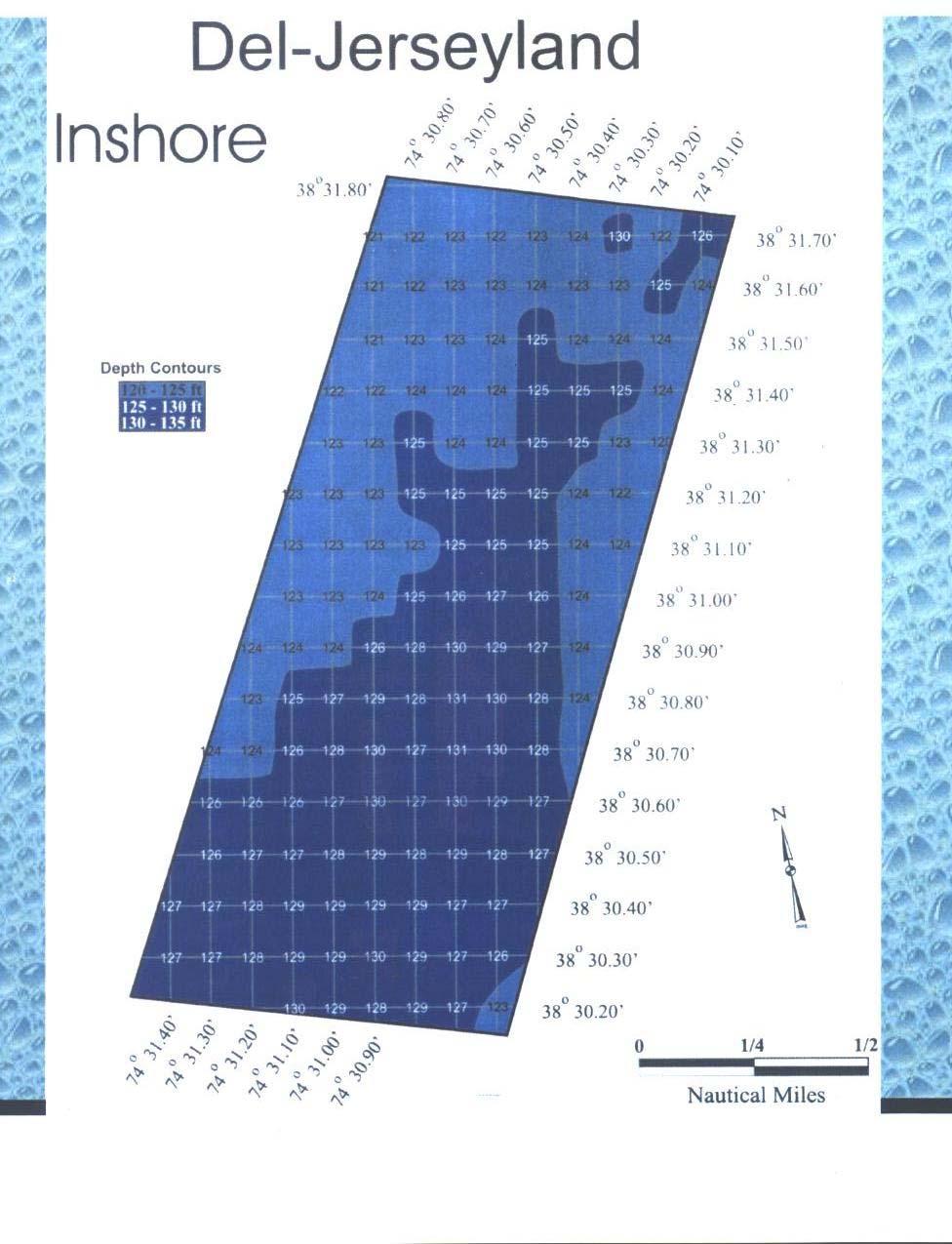
28 DEL-JERSEY-LAND INSHORE SITE Total area of site square nautical miles Depth range Distance from port - 26 NW from Indian River Inlet 30 NW from Cape May, NJ Inlet 30 NW from Ocean City, MD Inlet Invertebrate Colonization - Northern coral, Whip coral, Anemone community Fish - black sea bass, ocean pout, winter flounder, red hake, bluefish, Bluefin tuna, shark Gregory Poole 175 Minesweeper/Menhaden harvesting vessel (see front cover) sunk 12/2/ N W Scattered subway cars in the vicinity of the following coordinates: 44 cars 38º N 074º N 8/2/09 44 cars 38º N 074º W 8/30/09 44 cars 38º N 074º W 9/30/09 44 cars 38º N 074º W 9/12/09
29
30 STATE OF DELAWARE DEPARTMENT OF NATURAL RESOURCES & ENVIRONMENTAL CONTROL DIVISION OF FISH & WILDLIFE FISHERIES BUILDING 3002 Bayside Drive Dover, Delaware FW FISHERIES
New Jersey Scuba Diver - Artificial Reefs - Townsends
 Page 1 of 7 Townsends Reef Home & Search Artificial Reefs Contents Top of Page Deepwater Reef Latest News Prev Next Dive Sites Marine Biology Artifacts & Shipwrecks Gear & Training Bay Jack Donna's Star
New Jersey Division of Fish and Wildlife. Excerpts from REEF NEWS 1999 OBJECTIVES OF THE REEF PROGRAM. WHAT DO ANGLERS THINK of the REEF PROGRAM?
 New Jersey Division of Fish and Wildlife Excerpts from REEF NEWS 1999 OBJECTIVES OF THE REEF PROGRAM New Jersey's Reef Program is administered by the DEP's Division of Fish and Wildlife. The objectives
New Jersey Division of Fish, Game and Wildlife Excerpts from REEF NEWS 1998
 New Jersey Division of Fish, Game and Wildlife Excerpts from REEF NEWS 1998 OBJECTIVES OF THE REEF PROGRAM New Jersey's Reef Program is administered by the DEP's Division of Fish, Game and Wildlife. The
East Central Florida Region Matt Culver, Brevard County James Gray, Indian River County Jim Oppenbourn, St. Lucie County Kathy Fitzpatrick, Martin
 James Gray, Indian River County January 14, 2015 East Central Florida Region Matt Culver, Brevard County James Gray, Indian River County Jim Oppenbourn, St. Lucie County Kathy Fitzpatrick, Martin County
2010 Edition. Longest Vessel Ever Reefed in the Atlantic Ocean To Make a Big Splash off Cape May
 2010 Edition Longest Vessel Ever Reefed in the Atlantic Ocean To Make a Big Splash off Cape May New Jersey anglers and scuba divers will soon have the opportunity to catch fish and dive on one of the largest
2005 Edition. Division of Fish and Wildlife. New Jersey Department of Environmental Protection
 2005 Edition A decommissioned Navy tanker will be the first vessel deployed by the Department of Environmental Protection, as part of a new initiative to improve New Jersey s artificial reefs and raise
2006 Edition New Jersey s new wrecks already teeming with life
 Helis (above and below). 2006 Edition New Jersey s new wrecks already teeming with life Deep in the Atlantic Ocean, several miles off New Jersey s famed coastline, an amazing assortment of tiny marine
2008 Edition. Stainless Steel Subway Cars On TRAC to New Jersey Reefs
 FREE COPY 2008 Edition Stainless Steel Subway Cars On TRAC to New Jersey Reefs The New Jersey Department of Environmental reef material. This change in DEP policy Protection Commissioner, Lisa P. Jackson,
WALTON COUNTY NRDA ARTIFICIAL REEF PROGRAM
 WALTON COUNTY NRDA ARTIFICIAL REEF PROGRAM Melinda Gates Lauren Floyd Kathryn Brown Beau Suthard, PG Franky Stankiewicz Walton County - Coastal Resource Liaison APTIM - Senior Marine Biologist APTIM -
FISHERIES MANAGEMENT PANEL
 FISHERIES MANAGEMENT PANEL TOM NOJI, DIRECTOR NOAA NATIONAL MARINE SCIENCE LAB AT SANDY HOOK SOREN DAHL, COORDINATOR FOR SEAGRASS MGMT. BUREAU OF MARINE RESOURCES, NYS DEC PETER CLARK, BUREAU OF MARINE
Vieques Underwater Demonstration Project
 Vieques Underwater Demonstration Project NOAA Office of Response and Restoration National Ocean Service 2006-2007 2007 University of New Hampshire Joint Hydrographic Center 2006 Science Application International
New Jersey Department of Environmental Protection Division of Fish and Wildlife Marine Fisheries Administration Bureau of Marine Fisheries
 New Jersey Department of Environmental Protection Division of Fish and Wildlife Marine Fisheries Administration Bureau of Marine Fisheries Survey of New Jersey s Recreational Wreck/Artificial Reef Fisheries,
Essential Fish Habitat: An overview of the consultation requirement for the American Association of Port Authorities
 Essential Fish Habitat: An overview of the consultation requirement for the American Association of Port Authorities National Marine Fisheries Service, Southeast Regional Office Habitat Conservation Division,
MBARA Diver s Reef Survey Form Updated 4 April 2010
 MBARA Diver s Reef Survey Form Updated 4 April 2010 Reef Site Name: MB 104 Unnamed Reef Position Readings: GPS Manufacturer & model: Garmin 188C N Lat.: 29 43.487 W Lon.: 85 41.562 Sonar Depth: Survey
2009 Edition. Department of Environmental Protection Postpones Deployments of Stainless Steel Subway Cars
 2009 Edition Department of Environmental Protection Postpones Deployments of Stainless Steel Subway Cars The New Jersey Department of Environmental Protection (DEP) recently announced that the state would
Ships 2-Reefs Program Annual Report
 Florida Fish and Wildlife Conservation Commission Ships 2-Reefs Program 2016-17 Annual Report Ships-2-Reefs Program In 2008, the Florida Legislature passed Ships-2-Reefs Program legislation (SB 432), Chapter
Georgia s Offshore Artificial Reef Project Historical Summary
 Georgia s Offshore Artificial Reef Project Historical Summary The Georgia Department of Natural Resources (GADNR) Offshore Artificial Reef (OAR) Project was established to develop long-term fisheries habitat
Lee E. Harris, Ph.D., P.E. Assoc. Professor of Ocean Engineering. Doug Bowlus and Ashley Naimaster Ocean Engineering Graduate Students
 FLORIDA TECH OCEAN ENGINEERING PROFESSOR LEE HARRIS AND HIS GRADUATE STUDENTS ASSIST WITH POST-HURRICANE IVAN CORAL REEF RESTORATION IN THE CAYMAN ISLANDS Lee E. Harris, Ph.D., P.E. Assoc. Professor of
OYSTER REEF RESTORATION; RESTORING ECOLOGICAL FUNCTION
 OYSTER REEF RESTORATION; RESTORING ECOLOGICAL FUNCTION Paul Jensen, David Buzan, and Ka-Leung Lee; Atkins Mark Dumesnil and Julie Sullivan; The Nature Conservancy Presentation Overview The Nature Conservancy
Virginia s saltwater recreational fisheries:
 Virginia s saltwater recreational fisheries: An introduction Willy Goldsmith PhD Candidate Virginia Institute of Marine Science College of William & Mary Who I am and what I am MA VA newenglandlighthouses.net
Predators, possibly attracted by the abundance of food and the sense of protection afforded by reefs, are always present.
 F ishermen have known for centuries that fish congregate around shipwrecks and natural anomalies on the bottom of coastal waters, such as oyster rocks, exposed bed rock and coral reefs. This has resulted
Delaware Division of Fish & Wildlife. Year 2005 Tidal Water Recreational Fishing Limits
 Delaware Division of Fish & Wildlife Year 2005 Tidal Water Recreational Fishing Limits No license is required for hook and line recreational fishing in tidal waters. It is illegal to fish for any species
DRAFT FOR REVIEW ARTIFICIAL REEF MANAGEMENT PLAN FOR NEW JERSEY. September, James E. McGreevey, Governor State of New Jersey
 DRAFT FOR REVIEW ARTIFICIAL REEF MANAGEMENT PLAN FOR NEW JERSEY September, 2004 James E. McGreevey, Governor State of New Jersey Bradley M. Campbell, Commissioner Department of Environmental Protection
NATIVE OYSTER RESTORATION AT ELKHORN SLOUGH, CALIFORNIA Summary of Elkhorn Slough National Estuarine Research Reserve and Elkhorn Slough Foundation
 NATIVE OYSTER RESTORATION AT ELKHORN SLOUGH, CALIFORNIA Summary of Elkhorn Slough National Estuarine Research Reserve and Elkhorn Slough Foundation partnership project Pain%ng by Cory and Catska Ench,
U.S. Fisheries - Sustainable Seafood Laurel Bryant
 U.S. Fisheries - Sustainable Seafood Laurel Bryant Chief, External Affairs NOAA Fisheries Communications Office Sustainable Seafood-3 Things Dynamic and every evolving NOAA - founding partner, global leader
2016 ANNUAL FISH TRAWL SURVEY REPORT
 216 ANNUAL FISH TRAWL SURVEY REPORT The University of Rhode Island Graduate School of Oceanography The Graduate School of Oceanography (GSO) Fish trawl survey began weekly sampling two stations in Narragansett
Peyton Robertson, Director, NOAA Chesapeake Bay Office Frank Dawson, Assistant Secretary, MD DNR Jeff Corbin, Assistant Secretary, VA Natural
 Peyton Robertson, Director, NOAA Chesapeake Bay Office Frank Dawson, Assistant Secretary, MD DNR Jeff Corbin, Assistant Secretary, VA Natural Resources Baywide Harvest 120 100 Harvest (Millions of Pounds)
Lat: Long: Captain: Crew: Topside conditions: Cloud cover (%): Wind Spd & Dir: Wave height (ft):
: Wind Spd & Dir: Wave height (ft):") Great Goliath Grouper Count: Survey Data Site name: Date: Dive# of day Lat: Long: Captain: Crew: Diver names: Topside conditions: Cloud cover (%): Wind Spd & Dir: Wave height (ft): Site type (check one):
Great Goliath Grouper Count: Survey Data Site name: Date: Dive# of day Lat: Long: Captain: Crew: Diver names: Topside conditions: Cloud cover (%): Wind Spd & Dir: Wave height (ft): Site type (check one):
Exploited Fishery Resources
 Exploited Fishery Resources Reading: Chapter 3 Invertebrate and vertebrate fisheries Diversity and life history species important globally species important locally involving Invertebrate Phyla Mollusca
Summer Flounder. Wednesday, April 26, Powered by
 Summer Flounder Wednesday, April 26, 2017 On February 2, 2017, the Summer Flounder, Scup and Black Sea Bass Management Board, part of the Atlantic States Marine Fisheries Commission (ASMFC), approved changes
Marine Recreational Information Program Transition to Improved Survey Designs
 Marine Recreational Information Program Transition to Improved Survey Designs David Gloeckner Southeast Fisheries Science Center Richard Cody Office of Science & Technology Improved Survey Designs Fishing
Reef Ball Designed Reefs Beaches, Turks and Caicos Final Report
 Reef Ball Designed Reefs Beaches, Turks and Caicos Final Report The Beaches Reef Ball Designed Reef Project has now been completed and being utilized by Beaches clients. As per the proposal submitted,
Atlantic Coast of Long Island, Fire Island Inlet to Montauk Point, New York Reformulation Study
 Atlantic Coast of Long Island, Fire Island Inlet to Montauk Point, New York Reformulation Study Work Order 16 Eastern Ecological Zone Finfish Creel Survey DRAFT December 12, 2000 Prepared for U.S. Army
Chart Features Maritime maps and Admiralty charts have these features:
 Introduction to Charts A chart or map of the area is an important safety item to carry on board. It allows the Master to obtain knowledge of the area to be travelled, and indicates the navigable channels
Lat: Long: Captain: Crew: Topside conditions: Cloud cover (%): Wind Spd & Dir: Wave height (ft):
: Wind Spd & Dir: Wave height (ft):") Great Goliath Grouper Count: Survey Data Site name: Date: Dive# of day Lat: Long: Captain: Crew: Diver names: Topside conditions: Cloud cover (%): Wind Spd & Dir: Wave height (ft): Site type (check one):
Great Goliath Grouper Count: Survey Data Site name: Date: Dive# of day Lat: Long: Captain: Crew: Diver names: Topside conditions: Cloud cover (%): Wind Spd & Dir: Wave height (ft): Site type (check one):
Ballast. Stability Lab Experiment. Have you ever been in a boat at sea in large waves? The boat moves up and down as the waves pass under the boat.
 Ballast & Stability Lab Experiment Have you ever been in a boat at sea in large waves? The boat moves up and down as the waves pass under the boat. In the Gulf of Mexico and other areas of the world, waves
Lat: Long: Captain: Crew: Topside conditions: Cloud cover (%): Wind Spd & Dir: Wave height (ft):
: Wind Spd & Dir: Wave height (ft):") Great Goliath Grouper Count: Survey Data Site name: Date: Dive# of day Lat: Long: Captain: Crew: Diver names: Topside conditions: Cloud cover (%): Wind Spd & Dir: Wave height (ft): Site type (check one):
Great Goliath Grouper Count: Survey Data Site name: Date: Dive# of day Lat: Long: Captain: Crew: Diver names: Topside conditions: Cloud cover (%): Wind Spd & Dir: Wave height (ft): Site type (check one):
Hello, my name is Speck. I am a Spotted Sea Trout and live in estuaries and in waters along the coast of the Atlantic Ocean.
 Hello, my name is Speck. I am a Spotted Sea Trout and live in estuaries and in waters along the coast of the Atlantic Ocean. Hi, my name is Spot and I am, well, a Spot, named for my spot just behind my
How to Build an Artificial Reef by condofish on July 23, 2010
 http://wwwinstructablescom/id/build-an-artificial-reef/ Home Browse Community Submit How to Build an Artificial Reef by condofish on July 23, 2010 Table of Contents License: Attribution Non-commercial
Warm-up # 7 A day 5/17 - B day 5/18 UPDATE YOUR TABLE OF CONTENTS
 Warm-up # 7 A day 5/17 - B day 5/18 UPDATE YOUR TABLE OF CONTENTS Question: List all examples of surface water on Earth. Answer: Rivers and streams, lakes and reservoirs, (ponds) wetlands, estuaries and
June NMFS Address 11, 2014 (NOAA): Council Address. Dover, DE 19901
: Council Address. Dover, DE 19901") BLACK SEA BASS SEASON OPENING FRAMEWORK ADJUSTMENT Discussion Document and Background June 2014 Mid-Atlantic Fishery Management Council in cooperation with the National Marine Fisheriess Service (NMFS)
BLACK SEA BASS SEASON OPENING FRAMEWORK ADJUSTMENT Discussion Document and Background June 2014 Mid-Atlantic Fishery Management Council in cooperation with the National Marine Fisheriess Service (NMFS)
Fresh, All Natural& Sustainable. January 2015
 Fresh, All Natural& Sustainable January 2015 Sourcing Sustainable Seafood Family Owned and Focused for Four Generations 2 Perishability Why is fish so much more perishable than meat? Harvesting - most
ARTIFICIAL REEF MANAGEMENT PLAN FOR MARYLAND
 ARTIFICIAL REEF MANAGEMENT PLAN FOR MARYLAND photo courtesy of Greg Hall Prepared By: Andrew J. Loftus and Richard B. Stone under Maryland Environmental Service Contract 06-07-58 June 2007 This page intentionally
Shipwrecks of Coron AKITSUSHIMA Sunk on September 24, 1944 by US Task Force 38 Location: Access: Condition:
 Shipwrecks of Coron AKITSUSHIMA One of the few true warships among the Coron wrecks, was the Akitsushima, a Japanese flying boat tender Location: Between Lajo Island and Manglet Island, south of Concepcion
***This summary does not include shad and herring net requirements.***
 South Carolina Department of Natural Resources Marine Resources Division Summary of Seine and Gill Net Laws (Saltwater) 2013-2014 This document should be kept on board all vessels using seines or gill
Artificial Reef Uses. Mitigation Shore Protection Scientific Studies Habitat Creation Conservation Economic Stimulus Diver Attractions
 Artificial Reef Uses Mitigation Shore Protection Scientific Studies Habitat Creation Conservation Economic Stimulus Diver Attractions Barbados Study The Relationship between Diver Experience Levels and
Commercial Season, Days, Times and Area Restrictions
 Summary of Maryland Commercial Fisheries Regulations FISH HEALTH HOTLINE: 1-888-584-3110 This is an abridged version of the regulations and does not include all regulated species. May not include Emergency
Evolution of Deepwater Coral Protection in the Southeast U.S
 Evolution of Deepwater Coral Protection in the Southeast U.S Tina Udouj, Florida Fish and Wildlife Conservation Commission Roger Pugliese, South Atlantic Fishery Management Council Overview Deepwater Corals
Species Conclusions Table
 Conclusions Table Project Name: Chesapeake Landing HOA- Breakwaters (NAO-14-0283) Date: February 25, 2014 /Resource Name Loggerhead sea turtle (Caretta caretta) Conclusion ESA Section 7 / Eagle Act Determination
SCIENTIFIC COMMITTEE NINTH REGULAR SESSION August 2013 Pohnpei, Federated States of Micronesia
 SCIENTIFIC COMMITTEE NINTH REGULAR SESSION 6-14 August 2013 Pohnpei, Federated States of Micronesia ANNUAL REPORT TO THE COMMISSION PART 1: INFORMATION ON FISHERIES, RESEARCH, AND STATISTICS WCPFC-SC9-AR/CNM-35
STATUS REPORT FOR THE SUBMERGED REEF BALL TM ARTIFICIAL REEF SUBMERGED BREAKWATER BEACH STABILIZATION PROJECT FOR THE GRAND CAYMAN MARRIOTT HOTEL
 August 23 STATUS REPORT FOR THE SUBMERGED REEF BALL TM ARTIFICIAL REEF SUBMERGED BREAKWATER BEACH STABILIZATION PROJECT FOR THE GRAND CAYMAN MARRIOTT HOTEL performed by Lee E. Harris, Ph.D., P.E. Consulting
BLACK SEA BASS NORTH OF CAPE HATTERAS DEALER PERMIT ISSUE PAPER. June 12, 2008 (REVISED) (NOTE: proposed rule under construction, eff.
 (NOTE: proposed rule under construction, eff.") BLACK SEA BASS NORTH OF CAPE HATTERAS DEALER PERMIT ISSUE PAPER June 12, 2008 (REVISED) (NOTE: proposed rule under construction, eff. July 1, 2008) I. ISSUE The requirement for licensed dealers to have
BLACK SEA BASS NORTH OF CAPE HATTERAS DEALER PERMIT ISSUE PAPER June 12, 2008 (REVISED) (NOTE: proposed rule under construction, eff. July 1, 2008) I. ISSUE The requirement for licensed dealers to have
ELIZABETH RIVER FACTS
 ELIZABETH RIVER FACTS How is she different from inland rivers? The Elizabeth River is an estuary a tidal finger of the Chesapeake Bay, rather than a freshwater river with a spring as origin. The Elizabeth
MAC Transit Advisories as of April 30, 2018
 MAC Transit Advisories as of April 30, 2018 The Mariners Advisory Committee for the Bay and River Delaware was established in October 1964. Its members and associate members are mainly comprised of master
VIDEO TRANSCRIPT. A Proposal to Expand the Flower Garden Banks National Marine Sanctuary An interview with Sanctuary Superintendent, G.P.
 VIDEO TRANSCRIPT A Proposal to Expand the Flower Garden Banks National Marine Sanctuary An interview with Sanctuary Superintendent, G.P. Schmahl (Opening scene of Flower Garden Banks National Marine Sanctuary
Admiralty Inlet Pilot Tidal Project FERC No Appendix C. Derelict Gear Monitoring Plan
 Appendix C Derelict Gear Monitoring Plan ADMIRALTY INLET PILOT TIDAL PROJECT FERC PROJECT NO. 12690 DERELICT GEAR MONITORING PLAN (submitted with the Final Application for a New Pilot Project License)
A PHYSICAL AND BIOLOGICAL SURVEY OF THE MID-REACH MITIGATION REEF SET NUMBER 1
 A PHYSICAL AND BIOLOGICAL SURVEY OF THE MID-REACH MITIGATION REEF SET NUMBER 1 John M. Hearin, Ph.D., P.E. 1 ; Geoff Swain, Ph.D. 2 ; Robert Weaver, Ph.D., P.E. 2 ; Kelli Z. Hunsucker, Ph.D. 2 ; Caglar
Fish Texas AQUATIC ECOSYSTEMS
 27 Additionally, healthy aquatic communities in Texas rivers, reservoirs and estuaries provide unparalleled recreational opportunities to millions of Texans. Our fresh and saltwater environments vary from
U.S. National Observer Program, Southeast Regional Fishery Observer Programs & Regional Electronic Technology Implementation Plans Jane DiCosimo
 Tab A, No. 7 Office of Science and Technology Silver Spring, MD U.S. National Observer Program, Southeast Regional Fishery Observer Programs & Regional Electronic Technology Implementation Plans Jane DiCosimo
NOAA s Underwater UXO Demonstration Projects Vieques Island, Puerto Rico
 NOAA s Underwater UXO Demonstration Projects Vieques Island, Puerto Rico Vieques Restoration Advisory Board Meeting May 7, 2008 Jason Rolfe NOAA s Office of Response & Restoration NOAA s Underwater UXO
Integrating basic and applied ecology using paired artificial natural reef systems.
 Integrating basic and applied ecology using paired artificial natural reef systems. Christopher D. Stallings 1, Kara R. Wall 1, Peter Simard 1, Jennifer E. Granneman 1, Kelly Kingon 2, and Christopher
Recovery, Reuse, and Recycling of Debris From the Demolition of the Grace and Pearman Bridges at Charleston, South Carolina
 Recovery, Reuse, and Recycling of Debris From the Demolition of the Grace and Pearman Bridges at Charleston, South Carolina Fred Cooper, P.E. Earth Tech AECOM Three Bridges Viewed From the Charleston Side
Florida Fish and Wildlife Conservation Commission (FWC)
") Florida Fish and Wildlife Conservation Commission (FWC) Mason Smith Florida Fish and Wildlife Conservation Commission Division of Marine Fisheries Management Version 1 FWC Mission To manage fish and wildlife
Florida Fish and Wildlife Conservation Commission (FWC) Mason Smith Florida Fish and Wildlife Conservation Commission Division of Marine Fisheries Management Version 1 FWC Mission To manage fish and wildlife
Unless otherwise noted, images throughout the presentation are by FWC.
 This presentation provides an update on current programs in place to collect catch and effort data for Florida s saltwater recreational fisheries, including the Gulf Reef Fish Survey (GRFS) and potential
REBUILDING THE ECONOMY, ONE OYSTER AT A TIME
 REBUILDING THE ECONOMY, ONE OYSTER AT A TIME NORTH CAROLINA SEA GRANT SUMMER 2010 This article originally appeared in the Summer 2010 issue of Coastwatch. BY BENJAMIN YOUNG LANDIS REBUILDING THE Economy,
CROC'S WALL NORTH MARK (16-40)
") Diving at Pomene is remote and very beautiful with no other operations in the area. We can easily guarantee that you will not be sharing the reefs with any other divers. The dives are however, a fair distance
Diving at Pomene is remote and very beautiful with no other operations in the area. We can easily guarantee that you will not be sharing the reefs with any other divers. The dives are however, a fair distance
PUBLIC NOTICE. US Army Corps of Engineers New England District 696 Virginia Road Concord, MA
 US Army Corps of Engineers New England District 696 Virginia Road Concord, MA 01742-2751 PUBLIC NOTICE Comment Period Begins: May 12, 2015 Comment Period Ends: June 12, 2015 File Number: NAE-2015-206 In
Lat: Long: Captain: Crew: Topside conditions: Cloud cover (%): Wind Spd & Dir: Wave height (ft):
: Wind Spd & Dir: Wave height (ft):") Great Goliath Grouper Count: Survey Data Site name: Date: Dive# of day Lat: Long: Captain: Crew: Diver names: Topside conditions: Cloud cover (%): Wind Spd & Dir: Wave height (ft): Site type (check one):
Great Goliath Grouper Count: Survey Data Site name: Date: Dive# of day Lat: Long: Captain: Crew: Diver names: Topside conditions: Cloud cover (%): Wind Spd & Dir: Wave height (ft): Site type (check one):
Artificial Reef Program. A Win for Our Ecosystem, a Win for Our Economy!
 Artificial Reef Program A Win for Our Ecosystem, a Win for Our Economy! A Boom for Economic Development Deploy 36 artificial reefs off the Coast of Naples/Marco/Collier County. Pay for the reefs with a
ADL Attachment 1
 (formerly) 106502 Kina Cove A reapplication for an expired lease. The type of commercial use is identical to that previously. The immediate off-shore tidelands will be used to dump, raft, and store round
Artificial Reefs of the Gulf of Mexico:
 Artificial Reefs of the Gulf of Mexico: A Review of Gulf State Programs & Key Considerations November 2013 Reef Pyramids being deployed into a Florida Bay Photo Courtesy of Florida Fish & Wildlife Conservation
ESSENTIAL FISH HABITAT HABITAT AREAS OF PARTICULAR CONCERN (EFH-HAPC) AND CORAL HABITAT AREAS OF PARTICULAR CONCERN (C-HAPC)
 AND CORAL HABITAT AREAS OF PARTICULAR CONCERN (C-HAPC)") ESSENTIAL FISH HABITAT HABITAT AREAS OF PARTICULAR CONCERN () AND CORAL HABITAT AREAS OF PARTICULAR CONCERN (C-HAPC) Shrimp Sargassum All coastal inlets, all statedesignated habitats of particular importance
ESSENTIAL FISH HABITAT HABITAT AREAS OF PARTICULAR CONCERN () AND CORAL HABITAT AREAS OF PARTICULAR CONCERN (C-HAPC) Shrimp Sargassum All coastal inlets, all statedesignated habitats of particular importance
SA New Trial Artificial Reef Project
 BACKGROUND PAPER SA New Trial Artificial Reef Project Development of options for the trial artificial reef 1. Summary CONTENTS Each year, an estimated 236,000 South Australians participate in recreational
Tuesday, August 30 th thru Sunday, September 25 th
 Tuesday, August 30 th thru Sunday, September 25 th Tournament Coordinator: Gordon GALLIGAN: 619-549-8043 cell 1. Object of the Tournament The object of this tournament is to provide a fun, equitable competition
West Coast Anchorages
 West Coast Anchorages This document aims to catalogue a number of anchorages along the West Coast of Tasmania where shelter may be sought. In addition the degree of protection from the wind, and holding
Geographic Response Plan Map: SC-17
 79 37'30"W Geographic Response Plan Map: SC-17 79 30'0"W 33 7'30"N Charleston County 33 7'30"N 33 0'0"N 79 37'30"W [ Awendaw [j [e!d!s(!d Graham Creek FRANCIS MARION NATIONAL FOREST 450 Awendaw Creek [j
Feasibility and Planning Study
 Feasibility and Planning Study Inland Bays Migratory Fish Passage Restoration Feasibility and Planning Study By Roy W. Miller Policy Coordinator A presentation about options and obstacles for allowing
Atlantic States Marine Fisheries Commission
 Atlantic States Marine Fisheries Commission Joint Meeting of the Summer Flounder, Scup, and Black Sea Bass and Bluefish Management Boards Draft Agenda July 6, 2016 10:00 a.m. 12:30 p.m. The times listed
MANAGEMENT DESIGNATIONS FOR MARINE AREAS
 Haystack Rock Garden (Inset ) single mussels may be taken for bait. Located within a 3 yard radius around the base of Haystack Rock, Cannon Beach, Clatsop County. Includes tide pools, and rocky or sandy
STAR FISH Fun for the Whole Family
 STAR FISH Fun for the Whole Family A recently built, clean, comfortable boat, annually inspected by the U.S. Coast Guard for your safety, permitted to carry over six passengers. STAR FISH has safety rails,
2001 Edition. New Jersey s Recreational Reef Fishery. Division of Fish and Wildlife. The Creation of a Marine Resource
 New Jersey s Recreational Reef Fishery The Creation of a Marine Resource New Jersey s reefs have come a long way in the past fifteen years. Prior to 1984, Sea Girt was the only active reef site off the
COXSWAIN NAVIGATION EXERCISES AUS197 NAME:
 COXSWAIN NAVIGATION EXERCISES AUS197 NAME: A deviation card is supplied at the end of this file. Check the answers Question 1 Using any chart (or use the AUS 197 extract) to: 1. Identify a distance of
The Science of Rebuilding Fisheries: State of Play and Current issues
 The Science of Rebuilding Fisheries: State of Play and Current issues Steve Murawski Director of Scientific Programs and Chief Science Advisor U.S. National Marine Fisheries Service OECD Workshop: Economics
UNDERWATER ARCHAEOLOGY Pickles Reef Florida Keys National Marine Sanctuary
 UNDERWATER ARCHAEOLOGY Pickles Reef Florida Keys National Marine Sanctuary MAHS Survey and Field School 2011 MAHS returned to Florida in June of 2011 to continue a survey of Pickles Reef begun in 2010.
The Shipwrecks of New Jersey s Reefs Edition. New Jersey Splashes NYC Subway Cars for Artificial Reefs FREE COPY. Newest Publication
 Newest Publication The Shipwrecks of New Jersey s Reefs This new publication provides 160 pages of photos, diagrams, historical information and sinking locations (LORAN and GPS) of 108 vessels sunk on
Cook Inlet pipeline crossing is about making the best choices
 Cook Inlet pipeline crossing is about making the best choices By Larry Persily lpersily@kpb.us Aug. 26, 2015 (This update, provided by the Kenai Peninsula Borough mayor s office, is part of an ongoing
Lesson 10: Oyster Reefs and Their Inhabitants
 Lesson 10: Oyster Reefs and Their Inhabitants Focus Question: What animals use oyster reefs for habitats? Objective: observe properties of animals found within a bag of oysters; Infer about the quality
Terrestrial Observations Chart Plot - Chesapeake Bay Entrance - Operational Level
 USCG 00326-NP-5 The following questions are based on chart 12221TR, Chesapeake Bay Entrance, and the supporting publications. The draft of your tow is 27 feet (8.2 meters). Use 10 W variation where required.
More and better research: a win for the fishermen and a win for the fish so why aren t Pew et al helping to provide it?
 More and better research: a win for the fishermen and a win for the fish so why aren t Pew et al helping to provide it? FishNet USA - July 27, 2012 Nils E. Stolpe Please feel free to reproduce or redistribute
Port of Port Elizabeth Information
 LOCATION Latitude 34º 01 S Longitude 25º 42 E PILOTAGE Pilotage is compulsory. Rendezvous point is 2.2 nautical miles NE of the port entrance on the leading lights. Pilot transfer is by pilot boat, unless
Atlantic States Marine Fisheries Commission
 Atlantic States Marine Fisheries Commission DRAFT ADDENDUM XXIV TO THE SUMMER FLOUNDER, SCUP AND BLACK SEA BASS FISHERY MANAGEMENT PLAN FOR PUBLIC COMMENT Summer Flounder Recreational Management in 2013
After Gear Time we join Donna Reynolds in the kitchen for Simple Cooking. Fish and Game are Donna s specialty and you won t be disappointed.
 OUR 22nd SEASON Carolina Outdoor Journal is a weekly fishing program designed to highlight the best angling opportunities found across the state of North Carolina. Each week the Journal travels to a different
Office of Science & Technology
 NOAA Fisheries Highlights of FEUS 2015 Highlights from the Annual Report Fisheries Economics of the United States, 2015 Office of Science & Technology Fisheries and the Economy U.S. fisheries provide jobs,
SOUTH ATLANTIC FISHERY MANAGEMENT COUNCIL
 1 SOUTH ATLANTIC FISHERY MANAGEMENT COUNCIL ONE SOUTHPARK CIRCLE, SUITE 306 CHARLESTON, SOUTH CAROLINA 29407-4699 TEL 843/571-4366 or FAX 843/769-4520 Toll Free 1-866/SAFMC-10 E-mail: safmc@safmc.net Web
SCI-5 MES_Lamb_Oceans Exam not valid for Paper Pencil Test Sessions
 SCI-5 MES_Lamb_Oceans Exam not valid for Paper Pencil Test Sessions [Exam ID:53S2JF 1 Two children are swimming and jumping in the waves at the beach. On which part of the ocean are they standing? A Abyssal
RIVER HERRING PROGRAM
 RIVER HERRING PROGRAM River Herring NORTHEAST REGION Assessing Sustainability of River Herring Runs Department of Marine Resources Award Amount... $400,483 Grantee Match... $415,340 Total Project... $815,823
South Atlantic Council Issues
 South Atlantic Council Issues Review and Discussion February 8, 2018 Florida Fish and Wildlife Conservation Commission Version 2 This is a review and discussion of actions from the South Atlantic Fishery
ARTIFICIAL REEF CONSTRUCTION: AN ENGINEERED APPROACH. Timothy K. Blankenship, P.E. R. Harvey Sasso, P.E.
 ARTIFICIAL REEF CONSTRUCTION: AN ENGINEERED APPROACH Timothy K. Blankenship, P.E. R. Harvey Sasso, P.E. Coastal Systems International, Inc. 464 South Dixie Highway Coral Gables, Florida 33146 Stephen Higgins
FISHING THE SOUTH TEXAS COAST
 FISHING THE SOUTH TEXAS COAST The Laguna Madre is approximately 100 miles of shallow flats bordered on one side by the Texas mainland and on the other by the barrier island known as Padre Island. Because
Eastern Brook Trout Joint Venture Annual Report The Nature Conservancy 2013
 Eastern Brook Trout Joint Venture Annual Report The Nature Conservancy 2013 2013 Annual Performance Report Enhancing Connectivity in the Ash-Black Rock Sub-basin of the West Branch Narraguagus River. Project