Manta Tow Survey on Atauro Island District of Dili Timor Leste, By: Marthen Welly, Andreas Muljadi, Constancio Dos Santos, Marcello Belo
|
|
|
- Rosalyn Richardson
- 6 years ago
- Views:
Transcription


1 Manta Tow Survey on Atauro Island District of Dili Timor Leste, 2014 By: Marthen Welly, Andreas Muljadi, Constancio Dos Santos, Marcello Belo
2 Manta Tow Survey on Atauro Island District of Dili Timor Leste, 2014 By: Marthen Welly, Andreas Muljadi, Constancio Dos Santos, Marcello Belo Cooperation between Ministry of Agriculture and Fisheries Timor Leste Coral Triangle Center
 Marcello Belo (MPA Committee of Atauro Island Timor Leste) Reference/Bibliography: Welly, M., Muljadi, H.A., Santos, C.D. & Belo, M.")
3 Report: Manta Tow Survey on Atauro Island District of Dili Timor Leste, 2014 Author: Marthen Welly (CTC MPA Learning Site Manager) Andreas Muljadi (CTC Nusa Penida Conservation Coordinator) Constancio Dos Santor (Minister of Agriculture and Fisheries of Timor Leste) Marcello Belo (MPA Committee of Atauro Island Timor Leste) Reference/Bibliography: Welly, M., Muljadi, H.A., Santos, C.D. & Belo, M Manta Tow Survey on Atauro Island District of Dili Timor Leste, Coral Triangle Center 17pp + v pp. Coral Triangle Center (CTC) Jalan Danau Tamblingan No.78, Sanur, Bali Indonesia (80228) Telephone ( ) ; Facsimile ( ) Photo and layout: CTC Supported by:
4 Foreword Praise to the Almighty God, for the gift and blessing that the survey to map the condition of coral reefs on Atauro Island, District of Dili Timor Leste, by using manta tow method can be completed. The survey that conducted from 8 March to 12 March 2014 has succeeded in mapping the condition of coral reefs, fish and important marine biota along 60 kilometers around Atauro Island. Hopefully, the collected data could be used to complete the database in order to support the establishment and management of Marine Protected Areas on Atauro Island Timor Leste. The results of this survey was an overview of the overall conditions of coral reefs on Atauro Island as an initial basis in elaborating a coral reef monitoring activities in the future with more detail techniques on some specific sites. In addition, the establishment of MPA on Atauro Island was a commitment of Timor Leste as a country member of CTI (Coral Triangle Initiatives) as stated on Timor Leste CTI National Plan of Action. We would like to thank Mr. Lorenco Borges Fontes (Director General for Agriculture and Fisheries), Mr. Augusto Fernandes (Director National of Agriculture and Fisheries), Mrs. Rili Djohani (Director Executive of CTC) and Mr. Johannes Subijanto (Deputy Director of CTC) for their support for the implementation of the survey, as well as Marine Protected Areas Committee of Atauro Island Timor Leste for their cooperation in the field. Hopefully the results of this survey can be a useful input in the effective management of coastal and marine biological resources on Atauro Island Timor Leste through the establishment of Marine Protected Area. April 2014 Team of Author
5 Table of Contents Foreword... iii Table of Contents... iv List of Tables... v List of Figures... v PREFACE... 1 Background... 1 Objective... 2 METHODOLOGY... 3 Manta tow (English, Wilkinson & Baker, 1997; Hill & Wilkinson, 2004)... 3 Time and Location... 8 Team of Survey... 8 RESULTS AND DISCUSSIONS... 9 An Overview of Atauro Island... 9 Conditions of Coral Reefs Hard Coral Cover Fish Abundance Threats on Aquatic Atauro waters CONCLUSION AND RECOMMENDATION BIBLIOGRAPHY APPENDIX... 16
6 List of Tables Table 1. List of manta tow survey team member on Atauro Island... 8 List of Figures Figure 1. Map of National Democratic Republic of Timor Leste...1 Figure 2. Manta tow surveyor towed by 18 meters rope attached to the ship... 3 Figure 3. Manta tow board... 4 Figure 4. Observation position of manta tow surveyor in flat coral reef... 6 Figure 5. Guidelines on percentage of coral cover with manta tow (Dahl, 1981 in English et al., 1997)... 7 Figure 6. Map of Atauro Island District of Dili, Timor Leste... 8 Figure 7. Route of manta tow survey on Atauro Island Timor Leste, Figure 8. Percentages of substrate cover on Aquatic Atauro waters, Figure 9. Percentages of hard coral live cover on Atauro Island waters, Figure 10. Fish abundance on Atauro Island waters Figure 11. Fish and other biota abundance on Atauro Island waters Figure 12. Map of distribution of important marine biota on Atauro Island waters, Timor Leste. 12 Figure 13. Map of location where cetacean was discovered on Atauro Island, Timor Leste... 13
.")
7 PREFACE Background The potential of Coral Triangle regions that was stated to have the highest marine biodiversity in the world has established cooperation among the incorporated countries as mentioned in Coral Triangle Initiatives on Coral Reefs, Fisheries and Food Security (CTI-CFF). This cooperation is primarily towards the sustainable marine resources management including coral reef resources, reef fish and food security for people, especially coastal and small islands communities. In addition, this cooperation also includes capacity building and experience sharing on management of marine, coastal and small islands regions from each state of the coral triangle. In its process, there were many initiatives in the development and establishment of Marine Protected Areas/MPA either as the initiation of government, community or an institution. Timor Leste as CTI member countries also showed an active role in this cooperation. Among others, there were some study plans for the development of MPA at several locations such as Atauro Island (Edyvane, de Carvalho, Penny, Fernandes, de Cunha, Amaral, Mendes & Pinto, 2009). Figure 1. Map of National Democratic Republic of Timor Leste.
8 Atauro Island as a small island has fairly complete coastal and marine ecosystems which are coral reefs, seagrass beds and few of mangroves forest. Seagrass on Atauro Island is quite spacious and people frequently saw dugongs at around waters that have seagrass beds. Atauro Island also has several quite long white sandy beaches where turtles often encountered lay their eggs in certain seasons. While Atauro Island waters is part of cetacean crossings (whales and dolphins). On the other hand, there are some threats such as destructive fishing, trash, sedimentation and development in coastal areas. The existence of potential and threats provide opportunities and challenges for the better management of marine resources with active involvement of community and government support that demonstrate combination of approaches of top-down and bottom-up. The initiation of MPA establishment on Atauro Island was a part of Timor Leste CTI National Plan of Action (Edyvane et al., 2009). One of the stages in the initiation of MPA establishment is availability of biophysical and socio-economic basic information. While the initial biophysical data that needs to be conducted is the manta tow survey on the condition of coral reef ecosystems. Objective This survey aims to find a general overview of the coral reef ecosystem conditions including the abundance (biomass) of fish and other important marine biota on Atauro Island as an initial assessment in mapping the potential and input for the development and management of Marine Protected Area (MPA) on Atauro Island, District of Dili Timor Leste.
9 METHODOLOGY Manta tow (English, Wilkinson & Baker, 1997; Hill & Wilkinson, 2004) Manta tow method is a coral reefs observation technique in a way the observer is behind the small motorboat using a rope as a connector between the boat and the observer (Figure 2). With a constant boat speed and passing over the coral reef with a length of tow is 2 minutes, the observer will see some objects that crossed by as well as a percentage value of coral live closure (hard corals and soft corals) and dead coral. Figure 2. Manta tow surveyor towed by 18 meters rope attached to the ship. The observed data is recorded on the data table by using the value of category or with the percentage value of integers. For additional information to support this observation, it can also be observed and recorded the percentage of sand closure and rubble and also other objects (Kima, Diadema and Acanthaster) that are visible in the trajectory of observation. At the beginner stage, observation using the manta tow method requires at least 4 people with each person has his own duties and functions, which are: 1 person is in charge of driving the motorboat. 1 person is in charge as an observer who is towed behind a boat. 1 person is in charge as a navigator who stays in front of the boat and sees the position of the boat in order to always be in between flat reef and reef edge.
10 1 person is in charge as a time keeper, his function is to pay attention to the observation time and inform the driver to stop the boat if the observation time has lasted for 2 minutes. All team members must know this method correctly and implement it with full of responsibility and in accordance with existing procedures, because it is closely related to the safety of all team members. A 20 meters rope is used to connect the manta board with the boat. The distance between the end of the boat with the observer is 18 meters so that the remaining length of the rope can be used to tie the end of the boat. The width of manta board and the length of the straps stretch should be noted to obtain a suitable distance between the observer and the end of the boat. Figure 3. Manta tow board.
11 Two buoys are installed at a distance of 6 meters and 12 meters from the end of the boat towards the manta board. The function of these buoys is as a sign to determine the brightness of seawater. White plastic board is used for data table. The data table that attached to the manta board should use an acrylic plastic with table position is placed in the middle of manta board so the data that seen by the observer can be written in the data table. Clock or stopwatch is used to determine the length of observation time. The length of observation time is 2 minutes on every towed. Global Positioning System is used for positioning. Because this tool (GPS) is quite expensive, then its application in the village is advisable to use nature signs that are on the beach (for example: leaning coconut trees at headland X, big rocks, permanent buildings, and others). Every two minutes after observation, the observer must determine his position by looking perpendicular to the shoreline and use nature signs as a reference of his position. For advanced stage, this observation can be done only by using a teamwork that consists of two people, which area one person as an observer and another one as a boat driver who also in charge as a time keeper to determine the length of time to pull. In order to conduct coral reef monitoring using this manta tow method, there are several equipment required such as: 1. Diving goggles (masks) 2. Breathing apparatus on water surface (snorkel) 3. Swimming aids in the foot (fins) 4. Motorboat (at least 5 PK) 5. Manta board with size of 60 cm length, 40 cm width, and 2 cm thick 6. Rope with length of 20 meters and diameter of 1 cm 7. Small buoy 8. White plastic board whose surface has been roughened with sand paper 9. Pencil 10. Eraser 11. Stop watch/clock 12. Global Positioning System (GPS)
12 A boat with a speed of approximately 5 PK is used to tow the observer and it can give sufficient speed for the observer to conduct observation well. The speed of this boat should be set so that it is not too fast and it is not too slow at the time of observation. The manta board with size of 60 cm x 40 cm x 2 cm (length x width x thickness) is used as a handle for observer and to lay the table board. The observer can also set the direction of movement to the right, left or even dive by moving this manta board. One hole in the middle of bottom part of manta board is required so that the observer can adjust his position at the time of observation. A 20 meters rope is used to connect the manta board with the boat. The distance between the end of the boat with the observer is 18 meters so that the remaining length of the rope can be used to tie the end of the boat. The width of manta board and the length of the straps stretch should be noted to obtain a suitable distance between the observer and the end of the boat. Two buoys are installed at a distance of 6 meters and 12 meters from the end of the boat towards the manta board. The function of these buoys is as a sign to determine the brightness of seawater. White plastic board is used for data table. The data table that attached to the manta board should use an acrylic plastic with table position is placed in the middle of manta board so the data that seen by the observer can be written in the data table. Clock or stopwatch is used to determine the length of observation time. The length of observation time is 2 minutes on every towed. Global Positioning System is used for positioning. Because this tool (GPS) is quite expensive, then its application in the village is advisable to use nature signs that are on the beach (for example: leaning coconut trees at headland X, big rocks, permanent buildings, name of the place, and others). Every two minutes after observation, the observer must determine his position by looking perpendicular to the shoreline and use nature signs as a reference of his position.
, with a constant speed of 3 5 km/hour or like people who walk slowly.")
13 Figure 4. Observation position of manta tow surveyor in flat coral reef. The observer towed in between flat coral reef and reef edge (Figure 4), with a constant speed of 3 5 km/hour or like people who walk slowly. If there is another factor that obstruct such as strong water currents then the speed of the boat can be increased in accordance with the sign from the observer who is behind the boat. The coral reef observation carried out for 2 minutes, and then stopped a few moments to allow time for observer to record data of several categories that were seen during 2 minutes of observations into data table that was available on manta board. After receiving a sign from observer the observation continued for 2 minutes, and so on until completed at the site boundary of observed coral reefs.

14 Figure 5. Guidelines on percentage of coral cover with manta tow (Dahl, 1981 in English et al., 1997). The filling of data for coral closure is preferably using percentages. This is to facilitate observer in determining each coral cover. Observer must pay attention to the total percentage of the sum of coral cover added with sand and other cover does not exceed 100% (Figure 5). The filling of data into data table depends on the purpose of observation itself. The data table on Table 1 is a simple example for coral reef monitoring that aims to determine the cover of hard corals, soft corals and dead corals that can describe the condition of coral reefs in general.

15 If the observation is intended to find out other information from the reef such as the abundance of spiny starfish, rubble, sand, sponge, clams, algae, and other coral reefs biota then the table of data may be modified in accordance with the purposes of observation. Time and Location This manta tow survey activity conducted on 7 13 March 2014, which covered around the Atauro Island with a total coastline length of 60 km. The survey team base camp was located at Barry's Eco-lodge, Beloi Village. Figure 6. Map of Atauro Island District of Dili, Timor Leste. Team of Survey The manta tow survey team members are contained in the following table:
16 Table 1. List of manta tow survey team member on Atauro Island. No Name Organization Position 1 Marthen Welly Coral Triangle Center Manta tow Surveyor 2 Andreas Muljadi Coral Triangle Center Manta tow Surveyor 3 Constancio Dos Santos Minister of Agriculture and GPS Fisheries of Timor Leste 4 Marchello Belo MPA Committee of Atauro Guide on the survey Island Timor Leste 5 Elias Minister of Agriculture and Fisheries of Timor Leste Rope and manta tow board keeper
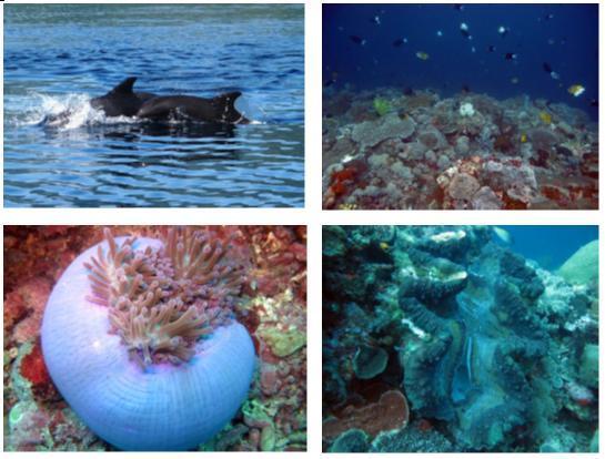
17 RESULTS AND DISCUSSION An Overview of Atauro Island Atauro Island or Goat Island is located about 25 kilometers in the northern part of Timor Leste that belongs to District of Dili. Atauro Island is located among Wetar Island, Alor Island and Kisar Island (Indonesia). Atauro Island has a circumference of coastline along 60 kilometers, with an area of 144 km 2 (NCC CTI Timor Leste, 2012). There are five main villages on Atauro Island namely Vila, Beloi, Makili, Makadade, and Biquelli. All villages are located on the coast, while Makadade Village is mostly located in the highlands of Atauro Island. In general, people there lived as fisherman and farmer. Fishermen on Atauro Island are subsistence fishermen who use fishing line and simple nets to catch fish. Seaweed cultivation is also one of the island's potential by contributing revenue of from seaweed exports in 2009 (NCC CTI Timor Leste, 2012). Atauro Island lies between Wetar Strait, Alor Strait and connected with the Banda Sea. Therefore, the aquatic around Atauro Island is an important migration path for cetacean (whales and dolphins). In certain month particullary from October to November, a group of whales are often found crossing the waters around Atauro Island. The CTC manta tow survey team together with the Ministry of Agriculture and Fisheries of Timor Leste and MPA Committee of Atauro Island could complete the entire survey with a total length of Atauro Island coast of about 60 kilometers.
18 Figure 7. Route of manta tow survey on Atauro Island Timor Leste, Conditions of coral reefs The general results of manta tow survey indicated that there was no components of substrate that dominant on Atauro Island waters including hard coral live, soft coral, rubble, abiotic which consist of dead coral, rocks and algae koralin (abiotic), and other components outside the four components previously (other). If the survey results viewed as a whole, then the abiotic component has composition which relatively higher compared to other components.

19 Figure 8. Percentages of substrate cover on Atauro Island waters, Hard Coral Cover The percentage of hard coral live cover on Atauro Island was between 12% 31% with an average of 20.2%. The percentage of coral cover on Atauro Island was included in low category. Some places that have coral cover with medium category above 25% were Baruana, Beloi, and Kasimeta. The poor of hard coral cover at several sites were due to high abiotic cover such in Berahara, Berau, Iliknamo, Pala and Tutumanu, and the high of rubble cover such in Akrema, Iliknamo, Pala and Raiketa. This rubble cover was allegedly due to blast fishing or dynamite fishing.
20 Figure 9. Percentages of hard coral live cover on Atauro Island waters, Fish Abundance During the manta tow survey, the recording of fish and important marine biota that encountered was also conducted. From the results of survey indicated that the abundance of fish on Atauro Island waters was high.
21 Figure 10. Fish abundance on Atauro Island waters. In some locations, there were found a very high fish abundance such as in western part and northern part of Atauro Island. It was found a collection of jack-travelly fish, yellow tail and barracuda in large enough quantities.
22 Figure 11. Fish and other biota abundance on Atauro Island waters. Bumphead parrotfish and napoleon fish could become an icon of Atauro Island since they were discovered relatively plenty. On Atauro Island waters there was also found some important marine biota, such as sea turtle, shark, and giant clam. Two types of turtles were found during the survey which was green turtle and hawksbill turtle, and type of reef shark, black-tip shark.
23 Figure 12. Map of distribution of important marine biota on Atauro Island waters, Timor Leste. When the survey was conducted, the team also encountered some species of whales and dolphins around Atauro Island waters. The species of dolphins found were Frasser dolphin, 13 Bottle-Nose dolphins, and Long-Nose dolphin. Meanwhile there were 30 whales from species of Melon- Headed found in front of Beloi village (Figure 13).
24 Figure 13. Map of location where cetacean was discovered on Atauro Island, Timor Leste. Threats on Atauro Island waters During the survey, it found various threats towards marine biodiversity on Atauro Island waters, which were: Destructive fishing Trash Sedimentation Development in coastal areas
25 The impact of destructive fishing can be seen from the coral damage which made it high in rubble closure of 25 35% as seen in Akrema, Iliknamo, Pala and Raiketa. While trash in the ocean was relatively seen plenty at Adara site. The development in coastal areas impacted on the amount of anthropogenic trash that found in every village. While sedimentation was relatively seen as the impact of the way along the coast like in Beloi.
26 CONCLUSION AND RECOMMENDATION The results of manta tow survey provide an overview of the overall conditions of coral reefs which cover 60 km around the coastline. The average cover of hard corals live is in the range of 12 31% with an average of 20.2%. The poor conditions of coral live cover were allegedly due to destructive fishing activities that resulting in coral damage that can be seen from the presence of rubble cover of up to 30%. Although the condition of coral reefs on Atauro Island waters is relatively low in terms of the hard coral live cover, however Atauro Island still has some fisheries and tourism potential with the presence of typical biota such as sharks, turtles, napoleon fish and bumphead fish as well as the abundance of economically important fish that relatively high. In addition, Atauro Island is also as a crossing of cetacean (whales and dolphins), and its seagrass beds are as habitat for dugongs. On the other hand, there are some threats to the preservation of natural assets on Atauro Island such as destructive fishing activities, trash, sedimentation and other impacts of the coastal development. From the results of manta tow survey, several sites that could be considered as a core zone and a sustainable fisheries utilization zone are Adara, Beloi, Baruana, Kasimeta, west and north of Atauro Island in terms of hard coral live closure and fish abundance that are relatively higher. From the existing potential and threats, Atauro Island has an opportunity to be managed properly. Therefore some survey and mapping still required to be conducted towards other important habitats such as seagrass beds as habitat for dugongs, turtle nesting beaches, fish spawning aggregation sites, fishing sites, fishermen distribution sites and types of fishing gear used in order to develop a database for the Atauro Island waters. The database can be used as an input in establishing a marine protected area on Atauro Island, especially in zoning plan. The results of manta tow also need to be disseminated to the public as part of socialization and cross checking of public knowledge as
27 well as an early initiation to uniform perception of stakeholders (public, private sector and government) in the establishment of MPA. As a small island ecosystem where the mainland is very closely related to conditions of the ocean, the MPA management on Atauro Island is also expected to be able to manage some issues on the mainland such as trash and the impact of coastal development that integrated with ocean management as stated in the draft of ridge to reef (GEF, ND.; IUCN, 2013).
28 BIBLIOGRAPHY English, S., Wilkinson C. and Baker V. (1997). Survey Manual for Tropical Marine Resources. 2nd edition. Townsville, QLD.: Australian Institute of Marine Science. Edyvane K., de Carvalho N., Penny S., Fernandes A., de Cunha C.B., Amaral A.L., Mendes M., and Pinto P. (2009). Conservation Values, Issues and Planning in the Nino Konis Santana Marine Park, Timor Leste Final Report. Ministry of Agriculture & Fisheries, Government of Timor Leste. Hill, J., Wilkinson, C. (2004). Methods for ecological monitoring of coral reefs. A resource for managers. Australian Institute of Marine Science, Townsville, Australia. NCC CTI Timor Leste. (2012). State of the coral reefs of Timor Leste. Coral triangle marine resources: their status, economies, and management. National CTI Coordinating Committee of Timor Leste. IUCN. (2013). Ridge to reef. Retrieved 9 April 2014 from GEF. (N.D.). From ridge to reef. Water, environment, and community security. GEF action on transboundary water resources. Global Environment Facility.


29 APPENDIX Appendix 1. Photos of Manta Tow Activities on Atauro Island waters (photo: CTC)

30 Appendix 2. Photos of Coral Reefs on Atauro Island waters (photo: CTC)
31
Case Study 3. Case Study 3: Cebu Island, Philippines MPA Network 10
 Case studies of mpa networks Case Study 3: Cebu Island, Philippines MPA Network 10 Location and background Cebu Island in the Philippines lies in the center of the Visayan Islands, known as an area high
Seagrass Surveys in Kampot
 Coastal Annual Forum 23 rd October 2014 Sihanoukville, Cambodia Seagrass Surveys in Kampot Presentation by Louis Bourne INTERNATIONAL UNION FOR CONSERVATION OF NATURE Presentation Overview Location and
Volunteer and Internships Programs ECUADOR
 Volunteer and Internships Programs ECUADOR Equilibrio Azul is a non-for profit organization created in 2005 to protect the marine resources of Ecuador. Our mission is to integrate local communities, governmental
Eastern Shore Islands Area of Interest Community Newsletter
 Eastern Shore Islands Area of Interest Community Newsletter Fall 2018 1ỊNTRODUCTION In addition to information on our Fisheries and Oceans Canada (DFO) website, we have now created a seasonal, community
LEGALITY OF COMMUNITY SURVEILLANCE GROUP & VILLAGE ENTERPRISES ALOR REGENCY, EAST NUSA TENGGARA
 REPORT LEGALITY OF COMMUNITY SURVEILLANCE GROUP & VILLAGE ENTERPRISES ALOR REGENCY, EAST NUSA TENGGARA Alexandra Maheswari Waskita WWF-INDONESIA This Project is executed by the Mohamed bin Zayed Species
marine protected areas
 marine protected areas Action Sheet 71 What is this Action Sheet about? If you live near the coast, you may know of local or national Marine Protected Areas (MPAs) or marine reserves. MPAs are tools to
OBSERVING CORALS and ALGAE:
 5 OBSERVING CORALS and ALGAE: MANTA TOW, SNORKEL SURVEY, and POINT-INTERCEPT TRANSECT A. Manta Tow Definition A manta tow survey is the observation of an underwater area of good visibility by a snorkeler
Management advisory for the Bay of Bengal hilsa fishery June 2012
 Page1 Management advisory for the Bay of Bengal hilsa fishery June 2012 What is the BOBLME RFMAC The BOBLME Project is supporting countries to implement an ecosystem approach to fisheries management of
no-take zone 1 of 5 Channel Islands National Marine Sanctuary, California
 This website would like to remind you: Your browser (Apple Safari 4) is out of date. Update your browser for more security, comfort and the best experience on this site. Encyclopedic Entry no-take zone
FISHERIES MANAGEMENT ACT 1998 AND FISHERIES (TORRES STRAIT PROTECTED ZONE) ACT 1984, CHAPTER 411.
 ACT 1984, CHAPTER 411.") NATIONAL FISHERIES AUTHORITY PO Box 2016, Port Moresby, National Capital District, Papua New Guinea Telephone: (675) 3212643, Facsimile: (675) 3202069, Email: nfa@fisheries.gov.pg FISHERIES MANAGEMENT
NATIONAL FISHERIES AUTHORITY PO Box 2016, Port Moresby, National Capital District, Papua New Guinea Telephone: (675) 3212643, Facsimile: (675) 3202069, Email: nfa@fisheries.gov.pg FISHERIES MANAGEMENT
dugon) ) and Seagrass in Thailand: Present Status and Future Challenges Kanjana Adulyanukosol Sombat Poovachiranon Mickmin Charuchida
 ) and Seagrass in Thailand: Present Status and Future Challenges Kanjana Adulyanukosol Sombat Poovachiranon Mickmin Charuchida") Dugong ( (Dugong dugon) ) and Seagrass in Thailand: Present Status and Future Challenges Kanjana Adulyanukosol Sombat Poovachiranon Mickmin Charuchida Phuket Marine Biological Center (PMBC) Department
Dugong ( (Dugong dugon) ) and Seagrass in Thailand: Present Status and Future Challenges Kanjana Adulyanukosol Sombat Poovachiranon Mickmin Charuchida Phuket Marine Biological Center (PMBC) Department
Derelict fishing gear and other marine debris: Australia and the Asia Pacific
 Derelict fishing gear and other marine debris: Australia and the Asia Pacific 9 June 2005 UNICPOLOS, New York Ilse Kiessling National Oceans Office Department of Environment and Heritage, Australia 1 Marine
Resort and Dive Operation Management, Marine Biology Support, Programmes and Training.
 Helen Sykes & Stuart Gow Mail: PO Box 2558 Government Buildings SUVA, Fiji Islands Tel: (679) 336 3625 or 359 2136 Email: resortsupport@connect.com.fj Resort and Dive Operation Management, Marine Biology
NINGALOO MARINE DEBRIS REPORT
 NINGALOO MARINE DEBRIS REPORT A Summary Report by Salty Times covering 30 Marine Debris Surveys of the Ningaloo Coastline. Report Contents What: Marine Debris surveys have been conducted along the Ningaloo
FISHERIES MANAGEMENT ACT 1998 AND FISHERIES (TORRES STRAIT PROTECTED ZONE) ACT 1984, CHAPTER 411.
 ACT 1984, CHAPTER 411.") NATIONAL FISHERIES AUTHORITY PO Box 2016, Port Moresby, National Capital District, Papua New Guinea Telephone: (675) 3212643, Facsimile: (675) 3202069, Email: nfa@fisheries.gov.pg FISHERIES MANAGEMENT
NATIONAL FISHERIES AUTHORITY PO Box 2016, Port Moresby, National Capital District, Papua New Guinea Telephone: (675) 3212643, Facsimile: (675) 3202069, Email: nfa@fisheries.gov.pg FISHERIES MANAGEMENT
Preserving New Caledonia s Marine Environment The benefits of a large and highly protected marine reserve
 A fact sheet from the Pew Bertarelli Ocean Legacy Project July 2015 Preserving New Caledonia s Marine Environment The benefits of a large and highly protected marine reserve Overview The ocean plays a
Running head: ENVIRONMENTAL AWARENESS: ENDANGERED MARINE ANIMALS IN AUSTRALIA
 Running head: ENVIRONMENTAL AWARENESS: ENDANGERED MARINE ANIMALS IN 1 Environmental Awareness: Endangered Marine Animals in Australia Jeffrey Clayton George Mason University GCH 360-002 Health and Environment
Reef Watch Guidelines
 Reef Watch Guidelines What is Reef Watch? Reef watch is a simple one-dive-one-survey method to record the health of coral reefs. The method is easily learnt and it is even easier to participate in the
Indonesia Scoping Report
 Asia and the Pacific Regional Expert Workshop on Ocean Accounts Indonesia Scoping Report Alan F. Koropitan Faculty of Fisheries and Marine Sciences, Bogor Agricultural University (IPB) alan@apps.ipb.ac.id
Marine Ecosystems. Aquatic Ecosystems Section 2
 Marine Ecosystems Marine ecosystems are located mainly in coastal areas and in the open ocean. Organisms that live in coastal areas adapt to changes in water level and salinity. Organisms that live in
LIFE BaĦAR for N2K Project Survey Findings. Leyla Knittweis on behalf of the LIFE BaĦAR for N2K Project
 LIFE BaĦAR for N2K Project - 2015 Survey Findings Leyla Knittweis on behalf of the LIFE BaĦAR for N2K Project Legally Protected Habitats Habitats Directive Directive 92/43/EEC: Protected marine habitats:
R.P. Prabath K. JAYASINGHE National Aquatic Resources Research and Development Agency (NARA) Colombo 15 SRI LANKA
 Colombo 15 SRI LANKA") Experience and the special requirements of Sri Lanka in addressing the impacts of bottom fisheries on vulnerable marine ecosystems and the long-term sustainability of deep-sea fish stocks in particular
Experience and the special requirements of Sri Lanka in addressing the impacts of bottom fisheries on vulnerable marine ecosystems and the long-term sustainability of deep-sea fish stocks in particular
Reef Check Australia. Magnetic Island Season Report 2016
 Reef Check Australia Season Report 16 Reef Check Foundation Ltd. (Australia) www.reefcheckaustralia.org PO Box 134 George St Brisbane QLD 43 This report should be cited as: M. Welch, J. Salmond and J.
TITLE: COASTAL EROSION AND LANDFORMS.
 TITLE: COASTAL EROSION AND LANDFORMS. AIM: What are the factors that influence the formation of coastal features along Fishing Pond beach Trinidad? LOCATION OF FIELD STUDY: The study was carried out in
DURING ALL ACTIVITIES, MAKE SURE YOU DON T DAMAGE THE REEF OR OTHER MARINE LIFE!
 Fish surveys Long term volunteers can take part in the fish surveys. These surveys are the most complex research we do with volunteers. You have to learn a lot, but in return you will receive a lot of
Coastal areas have become increasingly under threat in recent years. Climate change is having a huge effect on coastal areas, making them much more
 Why are some coastal environments under threat? Coastal areas have become increasingly under threat in recent years. Climate change is having a huge effect on coastal areas, making them much more likely
WHAT ARE ECOSYSTEMS? Dr. V. N. Nayak Professor of Marine Biology (Retd)
") WHAT ARE ECOSYSTEMS? Dr. V. N. Nayak Professor of Marine Biology (Retd) An ECOSYSTEM is an interacting system of plant, animals, and humans and the surrounding environment. An ecosystem contains living
WHAT ARE ECOSYSTEMS? Dr. V. N. Nayak Professor of Marine Biology (Retd) An ECOSYSTEM is an interacting system of plant, animals, and humans and the surrounding environment. An ecosystem contains living
UNIVERSITY OF CAMBRIDGE INTERNATIONAL EXAMINATIONS General Certificate of Education Advanced Subsidiary Level and Advanced Level
 UNIVERSITY OF CAMBRIDGE INTERNATIONAL EXAMINATIONS General Certificate of Education Advanced Subsidiary Level and Advanced Level *2677524077* MARINE SCIENCE 9693/03 Structured Questions May/June 2013 Paper
Habitat Fact Sheets. Rocky habitats are dominated by seaweeds and often mussels, which rely on the rocks for attachment.
 Habitat Fact Sheets Habitats in the Gulf of Maine serve many important roles for the environment and for humans as well. These include: cycling nutrients, filtering pollution, trapping sediments, storing
Managing the coral reef - The Great Barrier Reef Marine Park Authority Great Barrier Reef Coral Sea World Heritage Site Zoning
 Managing the coral reef - The Great Barrier Reef Marine Park Authority The Great Barrier Reef is the largest coral reef in the world. It is made of over 2900 individual reefs and 900 islands stretching
Proposal for the Turneffe Atoll Marine Reserve
 February, 2011 Proposal for the Turneffe Atoll Marine Reserve The stakeholders of Turneffe Atoll seek your support in designating Turneffe Atoll a multiple-use Marine Reserve. Active management of Turneffe
The Implications of Illegal, Unreported and Unregulated (IUU) Fishing in Production cost for Marine water small-scale fisheries: A Case
 Fishing in Production cost for Marine water small-scale fisheries: A Case") The Implications of Illegal, Unreported and Unregulated (IUU) Fishing in Production cost for Marine water small-scale fisheries: A Case Study of Mafia Island, Mainland Tanzania. Upendo Hamidu, Fatma Sobo
The Implications of Illegal, Unreported and Unregulated (IUU) Fishing in Production cost for Marine water small-scale fisheries: A Case Study of Mafia Island, Mainland Tanzania. Upendo Hamidu, Fatma Sobo
Baa Atoll Project. Hanifaru Training Guidelines
 Baa Atoll Project Hanifaru Training Guidelines Baa Atoll Project All six resorts in the Baa Atoll have come together with the local communities to form a working group to target environmental issues. The
WHALE SHARK (Rhincodon typus) RECOVERY PLAN
 RECOVERY PLAN") WHALE SHARK (Rhincodon typus) RECOVERY PLAN 2004-2009 Great Barrier Reef Marine Park Authority Background The whale shark (Rhincodon typus) is the world s largest fish, and one of only 3 filter-feeding
WHALE SHARK (Rhincodon typus) RECOVERY PLAN 2004-2009 Great Barrier Reef Marine Park Authority Background The whale shark (Rhincodon typus) is the world s largest fish, and one of only 3 filter-feeding
Preserving New Caledonia s Marine Environment The benefits of a large and highly protected marine reserve
 A fact sheet from the Pew Bertarelli Ocean Legacy Project July 2015 Preserving New Caledonia s Marine Environment The benefits of a large and highly protected marine reserve Overview The ocean plays a
Oceans Humans both depend on it and threaten it with their activities
 Oceans Humans both depend on it and threaten it with their activities Oceans Water covers nearly ¾ of the Earth s surface More than 50% of the world s population lives within an hour of the coast Oceans
SMOOTH HAMMERHEAD SHARK (HHS)
") SMOOTH HAMMERHEAD SHARK (HHS) (Sphyrna zygaena) HHS1 1. FISHERY SUMMARY Smooth hammerhead sharks (Sphyrna zygaena) are not currently managed under the QMS. No assigned fishing allowances exist. However,
SMOOTH HAMMERHEAD SHARK (HHS) (Sphyrna zygaena) HHS1 1. FISHERY SUMMARY Smooth hammerhead sharks (Sphyrna zygaena) are not currently managed under the QMS. No assigned fishing allowances exist. However,
ALILA PURNAMA SAMPLE ITINERARY AMBON MAUMERE 12 Days / 11 Nights Journey. moments.
 AMBON - MAUMERE ALILA PURNAMA SAMPLE ITINERARY AMBON MAUMERE 12 Days / 11 Nights Journey Embark on a 12-day adventure on the Flores Sea to Banda Sea, from Ambon to Maumere, leisurely cruising the seas
CASE STUDY. Reef Check Dominican Republic GRANT NUMBER: SIDA QCL Submitted by: The Gulf and Caribbean Fisheries Institute, Inc.
 CASE STUDY Reef Check Dominican Republic Implementing Organization: Reef Check, Dominican Republic GRANT NUMBER: SIDA QCL-2324-3474-2661-2271. Submitted by: The Gulf and Caribbean Fisheries Institute,
LK Increasing knowledge on sea grass habitats and dugong distribution at selected sites in North Western Sri Lanka Project progress July2016
 LK6-2132 Increasing knowledge on sea grass habitats and dugong distribution at selected sites in North Western Sri Lanka Project progress July2016 ORCA Ocean Resources Conservation Association This is
REGIONAL TRAINING ON IDENTIFICATION OF SHARKS AND RAYS Species Visual ID and Design monitoring at Landing Site
 REGIONAL TRAINING ON IDENTIFICATION OF SHARKS AND RAYS Species Visual ID and Design monitoring at Landing Site 25 th 27 th February 2019 Novotel Lombok Resort and Villas, Lombok-West Nusa Tenggara Background
Marine Debris from Land to Sea: Holistic Characterization, Reduction and Education Efforts in New Hampshire
 Marine Debris from Land to Sea: Holistic Characterization, Reduction and Education Efforts in New Hampshire ABSTRACT Over time, the focus of marine debris research and work has shifted away from simply
Field Protocol for Monitoring Coral Reef Fisheries Resources in Belize
 Field Protocol for Monitoring Coral Reef Fisheries Resources in Belize Charles A. Acosta, PhD Wildlife Conservation Society Glover s Reef Marine Research Station P.O. Box 272 Dangriga, Belize and Department
Preliminary survey of the coral reefs
 Preliminary survey of the coral reefs from Beloi (Atauro Island, Timor-Leste): alternatives for sustainable use Centre for Ecological Economics and Water Policy Research University of New England, Armidale,
A Survey of Biodegradable and Non Biodegradable Debris on. Dominica s Coastal Zones
 A Survey of Biodegradable and Non Biodegradable Debris on Dominica s Coastal Zones Heather edina, Heather Woods, ichele Horner, Patricia Jimenez, Zac Zemanek Dominica 2011 Abstract: This report is a summary
marine sanctuary 1 of 5
 This website would like to remind you: Your browser (Apple Safari 4) is out of date. Update your browser for more security, comfort and the best experience on this site. Encyclopedic Entry marine sanctuary
Discover Scuba Diving
 Scuba Diving is the first ever dive operation on Tanna Island and is opening up the world class snorkelling reefs to the world, offering unspoilt, untouched & unbelievable aquatic experiences. Dive with
John Brewer Reef Sunferries-Townsville
 John Brewer Reef Sunferries-Townsville Latitude: 18 57.364S Longitude: 146 57.375E Date: 31-1-4, 1-2-4 and 24.3.4 Florent Cade 24 SITE DESCRIPTION John Brewer Reef is a mid shelf reef situated approximately
HOW CAN WE HELP TO SUSTAIN AQUATIC BIODIVERSITY?
 HOW CAN WE HELP TO SUSTAIN AQUATIC BIODIVERSITY? Marine Biodiversity The most marine biodiversity is found: 1. Coral reefs 2. Estuaries 3. Deep-ocean floor Biodiversity is higher near coasts than in the
Marine Management Strategy Frequently Asked Questions
 Marine Management Strategy Frequently Asked Questions Can I still go fishing at Rottnest? Yes Where will I be able to go fishing on Rottnest Island? Recreational fishing can occur at any location outside
Suraji Presented on CITES Non-Detriment Findings (NDFs) Workshop Jakarta, July 26, 2016
 Workshop Jakarta, July 26, 2016") Directorate of Conservation and Marine Biodiversity Directorate General of Marine Spatial Management Ministry of Marine Affairs and Fisheries Republic of Indonesia Suraji Presented on CITES Non-Detriment
Directorate of Conservation and Marine Biodiversity Directorate General of Marine Spatial Management Ministry of Marine Affairs and Fisheries Republic of Indonesia Suraji Presented on CITES Non-Detriment
Nordatlantisk Fiskeriministerkonference i Shediac 29. august 2017
 Naalakkersuisoq Karl-Kristian Kruses tale Nordatlantisk Fiskeriministerkonference i Shediac 29. august 2017 Dear friends and colleagues I would like to thank our hosts for this chance to visit beautiful
Policy Instruments for Fisheries Management and the Concept of Fisheries Refugia
 REVERSING ENVIRONMENTAL DEGRADATION TRENDS Policy Instruments for Fisheries Management and the Concept of Fisheries Refugia Christopher Paterson, UNEP/GEF South China Sea Project REVERSING ENVIRONMENTAL
GREEN FINS APPROACH FOR MANAGEMENT FOR SUSTAINABILITY
 GREEN FINS APPROACH FOR MANAGEMENT FOR SUSTAINABILITY OF CORAL REEFS AND DIVING TOURISM IN THAILAND Presented by Niphon Phongsuwan Department of Marine and Coastal Resources, Ministry of Natural Resources
Discover Scuba Diving
 Scuba Diving is the first ever dive operation on Tanna Island and is opening up the world class snorkelling reefs to the world, offering unspoilt, untouched & unbelievable aquatic experiences. Dive with
Thailand Coral Reef Conservation and Diving
 Thailand Coral Reef Conservation and Diving Join this marine conservation and diving programme and experience life in the crystal waters surrounding Koh Tao, Thailand's most beautiful tropical island Thailand
Re: Consultation on the addition of narwhal and two bowhead whale populations to the SARA List
 March 31, 2006 Central & Arctic Region SARA Coordinator Freshwater Institute Fisheries & Oceans Canada 501 University Avenue Winnipeg MB R3T 2N6 Re: Consultation on the addition of narwhal and two bowhead
World Oceans Day Does marine legislation actually protect the marine environment?
 World Oceans Day Does marine legislation actually protect the marine environment? 7 June 2012 Marine Protected Areas What the science tells us For biodiversity protection we need to protect at least 20%
Rapid assessment of SSF gear impact on bycatch and habitat
 Rapid assessment of SSF gear impact on bycatch and habitat Background and objectives: Fisheries sustainability requires, among other things, mitigation of ecosystem impacts of fishing gears. Scientific
Environmental Learning Outside the Classroom (ELOC)
") Environmental Learning Outside the Classroom (ELOC) This guidebook provides lesson ideas and activities to get students engaged with outdoor learning. Created by the Virgin Islands Marine Advisory Service
Environmental Learning Outside the Classroom (ELOC) This guidebook provides lesson ideas and activities to get students engaged with outdoor learning. Created by the Virgin Islands Marine Advisory Service
Commercial Fisheries in the South Coast s Marine Protected Areas
 STATE OF THE CALIFORNIA SOUTH COAST SUPPLEMENTAL REPORT COMMERCIAL FISHERIES Researchers from the California Department of Fish and Wildlife (CDFW) used landings data from CDFW s Commercial Fisheries Information
Legislative Council Panel on Food Safety and Environmental Hygiene Meeting on 8 March WWF s Submission
 Legislative Council Panel on Food Safety and Environmental Hygiene Meeting on 8 March 2011 WWF s Submission I. Introduction WWF welcomes the ban on all trawling in Hong Kong waters as announced in the
Strait of Georgia and Howe Sound Glass Sponge Reef Conservation Initiative
 Strait of Georgia and Howe Sound Glass Sponge Reef Conservation Initiative Presentation for the Howe Sound Community Forum October 13, 2017 Aleria Ladwig Resource Management Pacific Region 1 Presentation
Ibo Island Lodge SCUBA DIVING INFORMATION AND RATES IBO ISLAND LODGE, QUIRIMBAS ARCHIPELAGO NORTHERN MOZAMBIQUE
 Ibo Island Lodge SCUBA DIVING INFORMATION AND RATES IBO ISLAND LODGE, QUIRIMBAS ARCHIPELAGO NORTHERN MOZAMBIQUE Ibo Island Lodge has a resident PADI Dive Instructor and offers scuba diving to accredited
Reef Check Australia 2009 Great Barrier Reef Survey Season Report
 Reef Check Australia 2009 Great Barrier Reef Survey Season Report Supported by the Australian Government s Marine and Tropical Sciences Research Facility Project 1.1.2 Condition and trend of the Great
Essential Fish Habitat OCNMS Advisory Council July 13, 2013
 Essential Fish Habitat OCNMS Advisory Council July 13, 2013 John Stadler Habitat Conservation Division NMFS Northwest Region Essential Fish Habitat (EFH) What is it, where did it come from, and what does
Terms of Use. Copyright Natural Beach Living
 Terms of Use All rights reserved. No part of this packet may be reproduced, stored in a retrieval system, or transmitted in any form by any means - electronic, mechanical, photo-copies, recording, or otherwise
Relation between coral reef degradation and the Overexploitation of coral reef fishes in El-Tur region, Egyptian Red Sea Coast
 Relation between coral reef degradation and the Overexploitation of coral reef fishes in El-Tur region, Egyptian Red Sea Coast By Manal M. Sabrah and Azza A. El-Ganainy National Institute of Oceanography
OVERARCHING PRINCIPLES AND BEST PRACTICE GUIDELINES FOR MARINE MAMMAL WATCHING IN THE WIDER CARIBBEAN REGION (WCR)
") OVERARCHING PRINCIPLES AND BEST PRACTICE GUIDELINES FOR MARINE MAMMAL WATCHING IN THE WIDER CARIBBEAN REGION (WCR) OVERARCHING PRINCIPLES AND BEST PRACTICE GUIDELINES FOR MARINE MAMMAL WATCHING IN THE
OVERARCHING PRINCIPLES AND BEST PRACTICE GUIDELINES FOR MARINE MAMMAL WATCHING IN THE WIDER CARIBBEAN REGION (WCR) OVERARCHING PRINCIPLES AND BEST PRACTICE GUIDELINES FOR MARINE MAMMAL WATCHING IN THE
SALINITY. It's the amount of dissolved salts the water contains.
 AQUATIC ECOSYSTEMS SALINITY The types of organisms in an aquatic ecosystem depend upon the water s Salinity. It's the amount of dissolved salts the water contains. Salinity determines the two main aquatic
SA New Trial Artificial Reef Project
 BACKGROUND PAPER SA New Trial Artificial Reef Project Development of options for the trial artificial reef 1. Summary CONTENTS Each year, an estimated 236,000 South Australians participate in recreational
Exploring Women s s Roles in the PEI Fishery
 Exploring Women s s Roles in the PEI Fishery Irene Novaczek (Institute of Island Studies) and Sara Roach Lewis (Women for Environmental Sustainability) The Research Partnership Social Economy and Sustainability
Orange County MPA Watch A n n u a l R e p o r t
 Orange County MPA Watch 2 0 1 5 A n n u a l R e p o r t WHAT IS AN MPA? Marine Protected Areas (MPAs) are discrete geographic marine or estuarine areas designed to protect or conserve marine life and habitat.
Florida Fish and Wildlife Conservation Commission (FWC)
") Florida Fish and Wildlife Conservation Commission (FWC) Mason Smith Florida Fish and Wildlife Conservation Commission Division of Marine Fisheries Management Version 1 FWC Mission To manage fish and wildlife
Florida Fish and Wildlife Conservation Commission (FWC) Mason Smith Florida Fish and Wildlife Conservation Commission Division of Marine Fisheries Management Version 1 FWC Mission To manage fish and wildlife
KAMPOT PROVINCE CAMBODIA
 KAMPOT PROVINCE CAMBODIA KAMPOT In the south-western part of Cambodia Coastline: 93 km (include Keb) Coastline border:hatieng district, Vietnam to Koh Ses, Prey Nup district, Sihanouk Ville. Area of the
Artificial Habitats For Marine And Freshwater Fisheries READ ONLINE
 Artificial Habitats For Marine And Freshwater Fisheries READ ONLINE If searching for a book Artificial Habitats for Marine and Freshwater Fisheries in pdf form, then you've come to the right site. We furnish
Kuala Lawas INTRODUCTION. Why is Kuala Lawas IMPORTANT? DISTRIBUTION OF SEAGRASS IN THE WATERS OF LAWAS, SARAWAK.
 DISTRIBUTION OF SEAGRASS IN THE WATERS OF LAWAS, SARAWAK. Oswald Braken TISEN, James BALI, Samantha KWAN, Shirley NANING, Eda IZANIE. Regional Meeting on Conservation & Management of Sea Turtle Foraging
Your web browser (Safari 7) is out of date. For more security, comfort and the best experience on this site: Update your browser Ignore
 is out of date. For more security, comfort and the best experience on this site: Update your browser Ignore") Your web browser (Safari 7) is out of date. For more security, comfort and the best experience on this site: Update your browser Ignore MARINE S ANCTU ARY For the complete encyclopedic entry with media
Your web browser (Safari 7) is out of date. For more security, comfort and the best experience on this site: Update your browser Ignore MARINE S ANCTU ARY For the complete encyclopedic entry with media
ONEATA ISLAND TRAINING AND AWARENESS PROGRAM
 ONEATA ISLAND TRAINING AND AWARENESS PROGRAM 21st 28th of June 2018 This report documents the activities undertaken during the visit to Oneata which include Fish Warden training, General Fisheries Awareness,
P.O.Box 9152, Dar es Salaam TANZANIA.
 SHARED MANAGEMENT OF FISHERY RESOURCES IN TANZANIA fsoboster@mail.com, P.O.Box 9152, Dar es Salaam TANZANIA. Presentation Outline Introduction Fisheries importance Category of fisheries in Tanzania Fisheries
Ghost (net) Busters. Ghost Net Retrieval. Time to complete lesson: minutes
 Busters. Ghost Net Retrieval. Time to complete lesson: minutes") Ghost (net) Busters Ghost Net Retrieval Time to complete lesson: 20-30 minutes Purpose of module: This module allows students to simulate the removal of a derelict fishing net from a model coral reef.
Ghost (net) Busters Ghost Net Retrieval Time to complete lesson: 20-30 minutes Purpose of module: This module allows students to simulate the removal of a derelict fishing net from a model coral reef.
Council CNL(14)45 The management approach to salmon fisheries in Norway (Tabled by Norway)
45 The management approach to salmon fisheries in Norway (Tabled by Norway)") Agenda Item 6.2 Agenda Item 6.2 For Information Council CNL(14)45 The management approach to salmon fisheries in Norway (Tabled by Norway) 1983 1985 1987 1989 1991 1993 1995 1997 1999 2001 2003 2005 2007
Agenda Item 6.2 Agenda Item 6.2 For Information Council CNL(14)45 The management approach to salmon fisheries in Norway (Tabled by Norway) 1983 1985 1987 1989 1991 1993 1995 1997 1999 2001 2003 2005 2007
CROC'S WALL NORTH MARK (16-40)
") Diving at Pomene is remote and very beautiful with no other operations in the area. We can easily guarantee that you will not be sharing the reefs with any other divers. The dives are however, a fair distance
Diving at Pomene is remote and very beautiful with no other operations in the area. We can easily guarantee that you will not be sharing the reefs with any other divers. The dives are however, a fair distance
4.6 TOOL 6: EXAMPLE CODES OF CONDUCT SECTION FOUR BEST PRACTICE TOOLKIT
 TOOL 6: EXAMPLE CODES OF CONDUCT Each shark and ray operation is unique. It s important to develop a code of conduct that reflects this uniqueness, while also considering the latest science and best practice.
Designing Artificial Reefs and Cities: the shared principles
 Designing Artificial Reefs and Cities: the shared principles David Lennon, Constructed reefs, commonly referred to as artificial reefs (ARs) are basically underwater cities and their design and planning
Balancing food security and biodiversity in the ocean
 Balancing food security and biodiversity in the ocean Prof Heather Koldewey Head of Global Conservation Programmes @heatherkoldewey #oceanoptimism Thinking about biodiversity Thinking about fish Oceans:
Biogeographic Assessment of Florida Keys National Marine Sanctuary
 Biogeographic Assessment of Florida Keys National Marine Sanctuary NOAA National Centers for Coastal Ocean Science NOAA Florida Keys National Marine Sanctuary Florida Fish and Wildlife Commission Photos
Kuwait Reef Ball Licensed Reef Ball Contractors Gulf and Middle East Region
 Kuwait Reef Ball Licensed Reef Ball Contractors Gulf and Middle East Region Kuwait Reef Ball - Ecoseas Marine Contracting Company P.O Box 29643 Safat 13157, Kuwait Tel: 00-965-2465962/63 Fax: 2465964 Email:ecoseasadmn@hotmail.com
INSTITUTE OF FISHERIES RESEARCH
 INSTITUTE OF FISHERIES RESEARCH Fisheries statistics in Small-scale sector (Mozambique) In the Norwegian Fisheries Forum Seminar 4 5 October 2007 GENERAL INFORMATION Country area: 800 000 km 2 Marine waters:
LAKKOPETRA (GREECE) EUROSION Case Study. Contact: Kyriakos SPYROPOULOS. TRITON Consulting Engineers. 90 Pratinou Str Athens (GREECE)
 EUROSION Case Study. Contact: Kyriakos SPYROPOULOS. TRITON Consulting Engineers. 90 Pratinou Str Athens (GREECE)") LAKKOPETRA (GREECE) Contact: Kyriakos SPYROPOULOS TRITON Consulting Engineers 90 Pratinou Str. 11634 Athens (GREECE) Tel: +32 10 729 57 61 Fax: +32 10 724 33 58 e-mail: kspyropoulos@tritonsa.gr 19 1 1.
LAKKOPETRA (GREECE) Contact: Kyriakos SPYROPOULOS TRITON Consulting Engineers 90 Pratinou Str. 11634 Athens (GREECE) Tel: +32 10 729 57 61 Fax: +32 10 724 33 58 e-mail: kspyropoulos@tritonsa.gr 19 1 1.
Fishing and Marine Protected Areas: how can we best share the fish...?
 Fishing and Marine Protected Areas: how can we best share the fish...? Dr Zena Dinesen Overview of this presentation Explore some key resource allocation issues for fisheries and MPA management using examples
ECO. Adventures Camp. Environmental, Conservation, & Ocean. Key West, Florida
 ECO Environmental, Conservation, & Ocean Adventures Camp 2015 Key West, Florida Join the Adventure! Florida Keys Community College invites kids, ages 10 to 12, to be a part of its new Environmental, Conservation,
Cambodian Mekong Dolphin Conservation Project. Phay Somany Fisheries Administration Of Cambodia
 Cambodian Mekong Dolphin Conservation Project Phay Somany Fisheries Administration Of Cambodia Introduction The Cambodian Fisheries Administration (FiA) began research on Mekong River dolphins in January
Orange County MPA Watch 2016 A n n u a l R e p o r t
 Orange County MPA Watch 2016 A n n u a l R e p o r t WHAT IS AN MPA? Marine Protected Areas (MPAs) are discrete geographic marine or estuarine areas designed to protect or conserve marine life and habitat.
FISHERIES MANAGEMENT ACT 1998
 FISHERIES MANAGEMENT ACT 1998 THE GULF OF PAPUA PRAWN FISHERY MANAGEMENT PLAN THE NATIONAL FISHERIES AUTHORITY, by virtue of the powers conferred by Section 28 of the Fisheries Management Act 1998, and
Appendix Template for Submission of Scientific Information To Describe Ecologically or Biologically Significant Marine Areas
 Appendix Template for Submission of Scientific Information To Describe Ecologically or Biologically Significant Marine Areas Abstract (in less than 150 words) Coastal and marine areas: Africa Somalia has
Improving fishermen awareness to reduce the presence of lobster traps in MPAs of the Florida Keys. Gabrielle Renchen & Tom Matthews
 Improving fishermen awareness to reduce the presence of lobster traps in MPAs of the Florida Keys Spiny Lobster Advisory Panel Meeting Key Largo, FL April 25, 2016 Gabrielle Renchen & Tom Matthews Florida
Management advisory for the Bay of Bengal Indian mackerel fishery
 Management advisory for the Bay of Bengal Indian mackerel fishery What is the BOBLME RFMAC The BOBLME Project is supporting countries to implement an ecosystem approach to fisheries management of shared
Cult Dive: Barracuda Point Sipadan Island
 Cult Dive: Barracuda Point Sipadan Island Dive site: Barracuda Point Location: Malesia, Sipadan Island, 4 6' N / 118 37' E Type of dive: Wall, drift Maximum depth: 40 mt Level: intermediate to advanced
Essential Fish Habitat in the Mediterranean and its implications for Ecosystem Based Approach to Fishery Management
 Essential Fish Habitat in the Mediterranean and its implications for Ecosystem Based Approach to Fishery Management Fabio Fiorentino Institute for Coastal Marine Environment (IAMC) Italian National Research