2016 Monitoring and Response Plan for Asian Carp in the Upper Illinois River and Chicago Area Waterway System
|
|
|
- Roy Waters
- 6 years ago
- Views:
Transcription
1 2016 Monitoring and Response Plan for Asian Carp in the Upper Illinois River and Chicago Area Waterway System
2 Table of Contents ii Acknowledgements iii Glossary Executive Summary ES 1 Introduction 1 Background 1 Monitoring Projects 3 Seasonal Intensive Monitoring in the CAWS Strategy for edna Monitoring in the CAWS 11 Larval Fish Monitoring in the Illinois Waterway 15 Distribution and Movement of Small Asian Carp in the Illinois Waterway 19 Fixed Site Monitoring Downstream of the Dispersal Barrier 25 Removal Projects and Evaluation Response Actions in the CAWS 32 Barrier Maintenance Fish Suppression 37 Barrier Defense Asian Carp Removal 50 Identifying Movement Bottlenecks and Changes in Population Characteristics of Asian Carp in the Illinois River 52 Barrier Effectiveness Evaluation Telemetry Monitoring Plan 58 Understanding Surrogate Fish Movement with Barriers 69 Monitoring Fish Abundance, Behavior, and Barge Interactions at the Electric Dispersal Barrier 72 Monitoring Fish Density and Spatial Distribution in Lockport, Brandon Road, and Dresden Island Pools and the Associated Lock and Dam Structures 77 Assessing Population, Movement, and Behavior of Asian Carp to Inform Control Strategies 81 Analysis of feral Grass Carp in the CAWS and Upper Illinois River 85 Gear Development and Effectiveness Evaluation Evaluation of Gear Efficiency and Asian Carp Detectability 88 Gear Evaluation for Removal and Monitoring of Juvenile Asian Carp Species 91 Unconventional Gear Development 96 Monitoring Asian Carp using Netting with Supplemental Capture Techniques 99 Barrier Defense Removal of Asian Carp Using Novel Gear 104 Alternative Pathway Surveillance Alternative Pathway Surveillance in Illinois - Law Enforcement 106 Alternative Pathway Surveillance in Illinois - Urban Pond Monitoring 108 Appendices Appendix A - Participants in the Monitoring and Response Workgroup Appendix B - Best Management Practices to Prevent the Spread of Aquatic Nuisance Species during Asian Carp Monitoring and Response Field Activities Appendix C - Detailed Maps of Fixed and Random Site Sampling Locations Appendix D - Handling Captured Asian Carp and Maintaining Chain-of-Custody Records Appendix E - Shipping, Handling, and Data Protocols for Wild Captured Black Carp and Grass Carp Appendix F - Fish Species Computer Codes Appendix G - Sample Data Sheets Appendix H - Understanding Surrogate Fish Movement with Barriers Floy Tagging Data Sheet Appendix I - Analysis of Bighead and Silver Carp Spawn Patches Appendix J - Upper Illinois Waterway Contingency Response Planii i
3 Asian Carp Monitoring and Response Plan ACKNOWLEDGEMENTS The Asian Carp Monitoring and Response Plan was created by a team of biologists, scientists, managers, and administrators from state and federal agencies and includes technical input from government, university, and the private sector specialists. The original plan released in May 2010 was developed by S. Finney, R. Simmonds, S. Pescitelli, S. Shults, J. Mick, G. Sass, and R. Maher. This and earlier versions of the plan have benefitted from reviews by participants of the Monitoring and Response Work Group, Great Lakes state s natural resource agencies, nongovernmental organizations, and staff from the Illinois Department of Natural Resources Division of Fisheries, U.S. Army Corps of Engineers and U.S. Fish and Wildlife Service. K. Irons, J. Dettmers, K. Baerwaldt, J. Davis M. Shanks, N. Barkowski, E.Monroe, R. Simmonds, S. Finney, J. Stewart, N. Bloomfield, E. Pherigo, R. Neeley, M. O Hara, T. Widloe, B. Caputo, B. Bushman, J. Widloe, L. Nelson, J. R. Haun, R. Young, M. Brey, S. Butler, M. Diana, S. Collins, and D. Wahl contributed project write-ups for the plan. USFWS, IDNR, and INHS provided pictures for the cover. ii
4 GLOSSARY TERM DEFINITION C Degrees centigrade F Degrees Fahrenheit µs/cm microsiemen per centimeter A Amps ACRCC Asian Carp Regional Coordinating Committee ANCOVA Analysis of covariance ANOVA Analysis of variance ANS Aquatic Nuisance Species CAWS Chicago Area Waterway System CERL Construction Engineering and Research Laboratory cm Centimeter cm 2 Square centimeters CPO Conservation Police Officers CPUE Catch per unit effort CSSC Chicago Sanitary and Shipping Canal db Decibels DC Direct current DIDSON Dual Frequency Identification Sonar Diploid Fish with the natural number of reproductive chromosomes; are capable of reproducing ECALS edna Calibration Study edna Environmental DNA FWCO Fish and Wildlife Conservation Office g Grams GLFC Great Lakes Fisheries Commission GLMRIS Great Lakes Mississippi River Interbasin Study GPS Global Positioning System GSI Gonadosomatic index HACCP Hazard Analysis and Critical Control Points IDNR Illinois Department of Natural Resources INHS Illinois Natural History Survey IPC Internal positive control ISU Invasive Species Unit IWW Illinois Waterway kg Kilogram khz Kilohertz km Kilometer km/hr Kilometers per hour LOQ Limit of quantification LTRMP Long-Term Resource Monitoring Protocols m Meter m 2 Square meters iii
5 GLOSSARY TERM m 3 ml mm MRP MRWG MVN MWRD Ploidy QAPP RM SD SIM SIUC TL Triploid -TS UMESC USACE USCG USEPA USFWS USGS V v/cm V/in VHS W WGL yd YOY DEFINITION Cubic meters Milliliter Millimeter Asian Carp Monitoring and Response Plan Monitoring and Response Work Group Multivariate Normal Distribution Chicago Metropolitan Water Reclamation District Measurement of number of chromosomes, triploid fish are sterile Quality Assurance Project Plan River Mile Standard deviation Seasonal Intensive Monitoring Southern Illinois University Carbondale Total length Fish that have genetically modified to have an extra reproductive chromosome, rendering them sterile Target Strength USGS Upper Midwest Environmental Sciences Center U.S. Army Corps of Engineers U.S. Coast Guard U.S. Environmental Protection Agency U.S. Fish and Wildlife Service U.S. Geological Survey Volts Volts per centimeter Volts per inch Viral Hemorrhagic Septicemia Watts Whitney Genetics Laboratory Yard Young of year iv
6 Asian Carp Monitoring and Response Plan EXECUTIVE SUMMARY This Asian Carp Monitoring and Response Plan (MRP) was prepared by the Monitoring and Response Workgroup (MRWG), and released by the Asian Carp Regional Coordinating Committee (ACRCC). It is intended to act as an update to previous MRPs, and present up-todate information and plans for a host of projects dedicated to preventing Asian carp from establishing populations in the Chicago Area Waterway System (CAWS) and Lake Michigan. Specifically, this document is a compilation of 22 individual project plans, each of which plays an important role in preventing the expansion of the range of Asian carp, and in furthering the understanding of Asian carp location, population dynamics, behavior, and the efficacy of control and capture methods. Each individual plan outlines anticipated actions that will take place in 2016, including project objectives, methodology, and highlights of previous work. This plan builds upon prior plans developed in 2011, 2012, 2013, 2014, and More specifically, it is intended to act as an update to the multiyear, MRP that was developed in This 2016 MRP provides an update on specific project plans for activities that will take place in This 2016 MRP is intended to act as a living document, and will be updated at least annually. Updates will provide new information on project plans, as well as incorporate new information, technologies, and methods as they are discovered and implemented. A companion document, the 2015 Asian Carp Monitoring and Response Plan Interim Summary Reports (ISR), has also been completed by the MRWG. The 2015 ISR presents a summary of each individual project s activities, results, findings, and recommendations for future actions that were completed in Similar to the MRP, the ISR is intended to function as a living document, and will be updated at least annually. In conjunction, the 2016 MRP and 2015 ISR present a comprehensive accounting of the projects being conducted to prevent the establishment of Asian carp in the CAWS and Lake Michigan. Through the synthesis of these documents, the reader can obtain a thorough understanding of the most recent project results and findings, as well as how these findings will be used to guide project activities in the future. Two projects were completed in 2015, and are not included in plans for These projects are Des Plaines River and Overflow Monitoring and An Assessment of Water Guns to Deter Asian Carp. Two new projects have replaced these projects, and plans are included in this MRP. These new projects are Barrier Defense Removal of Asian Carp using Novel Gear and Analysis of Feral Grass Carp in the CAWS and Upper Illinois River. For the purpose of this MRP, the term Asian carp refers to Bighead Carp (Hypophthalmichthys nobilis) and Silver Carp (H. molitrix), exclusive of other Asian carp species such as Grass Carp (Ctenopharyngodon idella) and Black Carp (Mylopharyngodon piceus). Where individual projects address Grass Carp and Black Carp, they will be referenced specifically by name, and without using the generic Asian carp moniker. ES-1
7 Asian Carp Monitoring and Response Plan All MRPs to date, including the 2016 MRP, have benefitted from the review of technical experts and MRWG members, including, but not limited to, Great Lakes states natural resource agencies and non-governmental organizations. Contributions to this document have been made by various state and federal agencies. A brief accounting of the highlights of major initiatives outlined in the MRP are provided below. HIGHLIGHTS OF MAJOR INITIATIVES IN THE MRP Monitoring Projects Over 35,000 fish have been collected above the Electric Dispersal Barrier during seasonal intensive monitoring. No Asian carp have been observed since 2011, when a single Asian carp was captured in Lake Calumet. Two juvenile carp were captured in Marseilles pool near River Mile 256.4, and hundreds of captures of juvenile Asian carp were recorded in Starved Rock pool in 2015, indicating a significant expansion of the range of juvenile Asian carp towards Lake Michigan. The highest number of larval Asian carp in 6 years of sampling were observed during Asian carp spawning appears to be associated with a rising hydrograph. Fixed and random sampling below the Electric Dispersal Barrier has resulted in the collection of over 176,000 fish to date. No Asian carp have been captured in Brandon Road or Lockport Pools. The detectable Asian carp population front is near River Mile 280, approximately 47 miles from Lake Michigan. Additional effort was expended to sample the upper pools nearer the Electric Dispersal Barrier using supplemental capture techniques, including combinations of netting and electrofishing. Electrofishing was determined to be the most effective supplemental capture technique. No Asian carp edna was detected above the Electric Dispersal Barrier. Removal Projects and Evaluation Over 1,791 tons of Asian carp have been removed from the IWW below the Electric Dispersal Barrier during commercial harvest efforts. This tonnage was comprised of 79,077 Bighead Carp and 325,096 Silver Carp. Barrier Effectiveness Evaluation Telemetry study of tagged fish has observed no upstream passage past the Electric Dispersal Barrier. Both upstream and downstream inter-pool movement was observed in pools below the Electric Dispersal Barrier. 2,273 surrogate fish with similar behavior to Asian carp have been tagged to study movement across the Electric Dispersal Barrier and through locks and dams. Asian carp density in Dresden Island pool appeared to decrease consistently from This is a likely result of commercial harvest. ES-2
8 Asian Carp Monitoring and Response Plan Asian carp tend to move upstream in spring, and downstream in late summer and fall. Asian carp in lower pools also tend to display greater movement than Asian carp in pools closer to the Electric Dispersal Barrier. Total fish density (non-asian carp) near the Electric Dispersal Barrier tends to be greatest during summer. Schools of small fish (non-asian carp) were observed breaching the Electric Dispersal Barrier using DIDSON side-scan sonar. This study also revealed that barges passing through the Electric Dispersal Barrier reduce the electric field in the water column, and barges passing downstream through the Electric Dispersal Barrier allowed large schools of fish to pass upstream through the Electric Dispersal Barrier. Field testing indicated that water guns do not create an effective barrier to Asian carp movement. Gear Development and Effectiveness Evaluation Modifications to the configuration and deployment of nets and electrofishing arrays were explored, resulting in new deployment techniques that increase the coverage of net deployments and electrofishing arrays. Pound nets were determined to be both the most effective gear for capturing Asian carp in backwater ponds and lakes, as well as the most cost-effective gear. Relationships between capture gear and Asian carp size class were determined, with specific gear determined to be optimal for targeting specific size classes and age ranges of Asian carp. This study also indicated that juvenile Asian carp tend to favor near-shore habitats, and gradually move to deeper water as they increase in size. Alternative Pathway Surveillance 32 Bighead Carp have been removed from urban ponds since of the 28 ponds designated for investigation have either been sampled, emptied, or restored using rotenone to destroy existing fish. Law enforcement conservation officers have completed inspections of 5 aquaculture facilities and numerous fish trucks. These and other efforts have resulted in citations and ongoing multi-agency, cross-jurisdictional investigations into the illegal trade of invasive aquatic species More detailed results, analyses, and findings are included in the MRWG 2015 Interim Summary Report. The project plans resulting from the findings outlined above are described in detail in this MRP. As in the past, all projects discussed in this document have been selected and tailored to further the MRWG overall goal and strategic objectives. Overall goal: Prevent Asian carp from establishing self-sustaining populations in the CAWS and Lake Michigan. ES-3
9 Asian Carp Monitoring and Response Plan The five strategic objectives selected to accomplish the overall goal are: 1) Determination of the distribution and abundance of any Asian carp in the CAWS, and use this information to inform response removal actions; 2) Removal of any Asian carp found in the CAWS to the maximum extent practicable; 3) Identification, assessment, and reaction to any vulnerability in the current system of barriers to prevent Asian carp from moving into the CAWS; 4) Determination of the leading edge of major Asian carp populations in the Illinois River and the reproductive successes of those populations; and 5) Improvement of the understanding of factors behind the likelihood that Asian carp could become established in the Great Lakes. In keeping with the overall goal and strategic objectives, the 2016 plans for 22 projects are included in this MRP. These plans document the purpose, objectives, and methods for each individual project that will occur during The projects are grouped into five general categories: 1) Monitoring Projects 2) Removal Projects and Evaluation 3) Barrier Effectiveness Evaluation 4) Gear Development and Effectiveness Evaluation 5) Alternative Pathway Surveillance. A brief summary of the project plans in each category is provided below. MONITORING PROJECTS Seasonal Intensive Monitoring in the CAWS Seasonal intensive monitoring is a modified continuation of Fixed and Random Site Monitoring Upstream of the Dispersal Barrier and Planned Intensive Surveillance in the CAWS. These events will be planned for the spring season (Week of June 13 th and 20 th ) and the fall season (Week of September 19 th and 26 th ). This project includes standardized monitoring with pulsed- DC electrofishing gear and contracted commercial fishers at sites in the CAWS upstream of the electric barrier system. Monitoring also will include five fixed sites with additional random electrofishing transects and net sets at locations outside of fixed sites to maintain spatial coverage of the waterway. Along with maintaining the spatial coverage upstream of the Electric Dispersal Barrier, each seasonal intensive monitoring event will provide extra sampling focus on a unique location in the CAWs. The two week event in the spring will focus on the Lake Calumet/Cal-Sag area of the CAWs. In 2010 one Bighead Carp was captured with commercial nets and had numerous Rapid Response actions due to positive Asian Carp edna samples. In this event pulsed-dc electrofishing, tandem trap nets, Lake Michigan pond nets and contracted commercial fishers will be utilized. The two week event in the fall will focus on the North Shore ES-4
10 Asian Carp Monitoring and Response Plan Channel/Chicago River. The Seasonal Intensive Monitoring provides a spatially and temporally adequate assessment of relative abundance and distribution of Asian carp in the CAWS upstream of the Electric Barrier System. Strategy for edna Monitoring in the CAWS and Temporal edna Quantification Below the Electric Dispersal Barrier A modified strategy for edna monitoring that decouples edna as a trigger for response actions has been implemented since In 2016, the project will determine whether Asian carp DNA are present in strategic locations in the CAWS to inform the status of Asian carp, and detect Asian carp DNA in areas that have been monitored since 2009 to maintain annual data collection to maintain vigilance. Illinois River quantification objectives will be to detect and quantify Bighead and Silver Carp DNA along a gradient in the Illinois River from Lower Lockport pool to the Marseilles pool and the lower portion of the Kankakee River. This will complement other field efforts being conducted below the barrier, and may inform control or management actions in the future. Sampling will possibly confirm spawning events by timing three collection events pre-spawn, spawn, and post-spawn. This may inform control or management actions in the future. Larval Fish Monitoring in the Illinois Waterway Larval fish sampling will occur at approximately biweekly intervals at 12 sites located across the length of the Illinois Waterway (all navigation pools, including CAWS) from April to October. Additional sampling will occur at sites in the Sangamon, Spoon, Mackinaw, Fox, and Kankakee Rivers to assess potential Asian carp spawning in tributaries of the Illinois River. Sampling may occur more frequently during periods when Asian carp eggs and larvae are likely to be present (e.g., May - June, during periods of rising water levels, or shortly after peak flows). Observation of Asian carp eggs or larvae will help to inform other agencies of the upcoming likelihood of capturing young-of-year Asian carp. Analyses of the spatial and temporal distribution of Asian carp eggs and larvae will aid in identifying spawning locations, environmental factors associated with successful reproduction, and factors contributing to Asian carp recruitment. Distribution and Movement of Small Asian Carp in the Illinois Waterway This project specifically targets sampling of young Asian carp in areas not sampled by standard monitoring and gear evaluation projects in an effort to better understand distribution and habitat use by young Bighead and Silver Carp in the Illinois Waterway. Specific areas include tributaries and shallow backwater habitats known to function as nursery areas for young Asian carp. Movement patterns of young will be determined with acoustic telemetry. Sampling will occur during the months of April through October. Sampling effort will be distributed between Starved Rock, Marseilles, Dresden Island and Brandon Road pools. Marseilles and Dresden Island pools will be sampled for at least eight and ten crew weeks respectively. Fixed and Random Site Monitoring Downstream of the Dispersal Barrier This project includes standardized monitoring with pulsed-dc electrofishing gear and contracted commercial fishers at four fixed sites downstream of the Electric Dispersal Barrier ES-5
11 Asian Carp Monitoring and Response Plan system in Lockport pool, Brandon Road pool, and Dresden pool. Fixed and random site pulsed-dc electrofishing will take place bi-weekly from March through December, except during June and September, and will include 8 random sites in the Lockport, Brandon Road, and Dresden Island pools, respectively. Contracted commercial fishing will take place biweekly from March through December, except during June and September. An additional commercial fishing crew will be utilized compared to prior years, and contract fishing crews will target areas believed to have the highest densities of fish based on other monitoring projects and past fishing results. Additional gears such as hoop nets and mini-fyke nets will be continued to enhance monitoring for adult and juvenile Asian carp. Results will provide information on the location of detectable Asian carp populations in the waterway (relative abundance and distribution) and their progression upstream over time. Population data may be compared among sites and across time. This increased effort downstream of the Electric Dispersal Barrier system will help us to better evaluate the leading edge of the Asian carp population front in the Dresden Island pool. REMOVAL PROJECTS AND EVALUATION Response Actions in the CAWS This project includes a threshold framework to support decisions for response actions to remove any Asian carp from upstream of the Brandon Road Lock and Dam to Lake Michigan with conventional or experimental gears. It also allows for targeted response actions at selected locations in the CAWS outside the threshold framework when information gained from such actions may benefit monitoring protocols and Asian carp removal efforts. Barrier Maintenance Fish Suppression This project provides a fish suppression plan to support USACE maintenance operations at the electric dispersal barrier system. The plan includes clearing fish from between barriers with various fish driving and removal techniques and evaluating clearing success with split-beam hydroacoustics, side scan SONAR, and DIDSON imaging SONAR. Barrier Defense Asian Carp Removal Project This program was established to reduce the numbers of Asian carp downstream of the electric barrier system through targeted and contracted commercial fishing. Reducing Asian carp populations is anticipated to lower propagule pressure and the chances of Asian carp gaining access to waters upstream of the Electric Dispersal Barrier system. Primary areas that will be fished include Starved Rock and Marseilles pools. Identifying Movement Bottlenecks and Changes in Population Characteristics of Asian Carp in the Illinois River Spatially explicit population model- Reach-specific Asian carp demographic parameters will be updated using Bayesian methodology using additional data collected in the previous year. Stockrecruitment relationships will be refined to limit the largest source of variation in past models. This information will be used to complete the spatially-explicit Asian carp population model for ES-6
12 Asian Carp Monitoring and Response Plan the IWW, including inter-reach movement probabilities. This model will be used to predict the number of Asian carp that would likely reach the Electric Dispersal Barrier under various harvest scenarios. Probability of movement and dam passage-telemetry and tagging- The results of additional tagging and tracking efforts completed in previous years will be used to parameterize a model that can estimate the probabilities of Asian carp transitioning among pools in the IWW. Abundance, Demographics, and Hybridization- This project will use the approaches developed in previous years ( ) to determine Asian carp density, biomass, species composition, and size structure in the Illinois River. To quantify fish targets, a combination of side-looking and down-looking hydroacoustics and side-scan sonar techniques will be used. Surveys transects will be conducted in main channel, tributaries, side channels, and connected backwater lakes from Dresden Island Lock and Dam downstream to the purported source of the Asian carp population near the confluence of the Mississippi River. BARRIER EFFECTIVENESS EVALUATION Telemetry Monitoring Plan This project uses ultrasonically tagged Asian carp and surrogate species to assess if fish are able to challenge and/or penetrate the Electric Dispersal Barrier and pass through navigation locks in the upper Illinois Waterway. An array of stationary acoustic receivers and mobile tracking will be used to collect information on Asian carp and surrogate species movements. Understanding Surrogate Fish Movement with Barriers This project investigates the movements of tagged surrogate fish species in the Dresden Island, Brandon Road, and Lockport pools, along with specific areas such as Brandon Road Lock and Dam and below the Electric Dispersal Barrier Area in Lockport pool. The project will assess the movement of surrogate fish species between barriers and obtain recapture rates to help verify sampling success using multiple gears. Monitoring Fish Abundance, Behavior, and Barge Interactions at the Electric Dispersal Barrier, Chicago Sanitary and Ship Canal, Illinois This project continues to evaluate non-asian carp fish behavior between the narrow arrays where the highest-voltage electrical field is located and determine the species of fish present in and directly adjacent to the barrier system. Other components of the project will evaluate behavior of fish near the barrier as barges traverse the barriers and their behavior near barges at the Brandon Road Lock and Dam and in downstream areas of high Asian carp abundance. This project will also evaluate the potential for transport of eggs/larvae by barges, and will evaluate potential operational protocols to avoid barge entrainment. ES-7
13 Asian Carp Monitoring and Response Plan Monitoring Fish Density and Spatial Distribution in Lockport, Brandon Road, and Dresden Island Pools and the Associated Lock and Dam Structures Fish abundances and distributions from the Electric Dispersal Barrier to Dresden Island Lock and Dam will be estimated using hydroacoustic sampling following methods from Garvey et al. (2011). Scanning surveys of the Electric Dispersal Barrier are currently being conducted on a biweekly basis. Seasonal (Spring, Summer, and Fall) scans will be done of Lockport, Brandon Road, and Dresden Island pools. Additional scans may be added at the discretion of project biologists. Split-beam hydroacoustics and side-scan SONAR will be used to survey fish. Transects will be made parallel to the flow of the river and spaced close enough together to maximize coverage of the water column. Diel sampling will take place in order to assess fish distribution patterns near the barrier throughout a 24-hour period. Complete barrier scans will take place three consecutive times every three hours. This information will be especially useful given that some evidence exists that Bighead Carp move more in the evening hours than during daylight hours (Schultz 2006). Diel surveys will be performed when Lockport pool SONAR scans indicate that fish are in high abundance near the barrier, most likely in the summer and fall. Assessing Population, Movement, and Behavior of Asian Carp to Inform Control Strategies Asian carp abundance, movement, and behavior will be characterized through sampling and the use of hydroacoustic telemetry. Special focus will be placed on Starved Rock Lock and Dam and Brandon Road Lock and Dam, as they have been identified as potential control points for Asian carp populations. This study will evaluate the frequency of Asian carp approach and passage through the locks and dams, as well as characterize differences in Asian carp populations on either side of the barriers. Analysis of Feral Grass Carp in the CAWS and Upper Illinois River This is a new project in 2016, and aims to evaluate the extent of Grass Carp populations through targeted sampling events in the Upper IWW. Grass Carp will be captured and tagged for telemetric tracking. Sampling will take place from May October, as will tagging and tracking of fish movements. Following data collection, an analysis of fish movement trends will be completed. GEAR DEVELOPMENT AND EFFECTIVENESS EVALUATION Evaluation of Gear Efficiency and Asian Carp Detectability This project will continue to assess efficiency and detection probability of sampling gears used for Asian carp monitoring. Sampling in 2016 will focus on evaluation of gears for capturing juvenile Asian carp. Sites in the LaGrange, Peoria, Starved Rock, Marseilles, and Dresden Island Pools will be sampled with a variety of gears (mini-fyke nets, beach seines, purse seines, gill nets, pulsed-dc electrofishing, push-frame nets, hydroacoustics). Analyses will examine the ability of each gear to capture age-0 through age-2 Asian carp and for their effectiveness at capturing other species of small-bodied fishes. Detection probability modeling will continue to examine the probability of capturing Asian carp with various gears. Work in 2016 will incorporate other ES-8
14 Asian Carp Monitoring and Response Plan sources of sampling data, examine additional gear types, assess multi-gear models, and explore detection probability for various native species. These analyses will be used to determine site characteristics and sampling gears that are likely to maximize the probability of capturing Asian carp, estimate the amount of effort required to detect Asian carp at varying densities, and use native species with similar traits as Asian carp to estimate potential differences in detection probabilities between the Illinois River and the CAWS. Results will be reported to management agencies to inform them on gear choices and appropriate levels of sampling effort. Gear Evaluation for Removal and Monitoring of Juvenile Asian Carp Species Four innovative trawling methods and traditional boat electrofishing will be deployed in backwater habitats of the Illinois River once a month May through October Gears that will be evaluated include a dozer trawl, traditional boat electrofishing, a surface trawl, and a paupier butterfly trawl. Gears will be evaluated and compared for their efficacy at capturing juvenile Asian carp. Unconventional Gear Development In 2016, pound nets will be set at appropriate backwater habitats on the IWW in continued collaboration with USGS personnel testing the effectiveness of feeding attractants and sound stimuli for attracting/deterring Asian carp. Experiments will involve comparisons of pound nets set with and without the feeding attractant or sound stimuli. All captured fish will be identified to species, and measured for total length and weight. Results of these trials will be reported by USGS. Pound nets will continue to be used to assist IDNR with monitoring and control efforts in the upper IWW. INHS will also help aid in the deployment of pound nets and training of personnel from other agencies that express interest in utilizing this gear type. Additional new gears and gear combinations may be incorporated into sampling efforts as they become available. Monitoring Asian Carp Using Netting with Supplemental Capture Techniques Further studies will be completed to continue to evaluate supplemental capture techniques. These supplemental techniques include electrofishing, complex sound, and non-directional sound. These techniques will be evaluated in Dresden Island, Marseilles, and Starved Rock pools through standardized sampling at fixed sites. Barrier Defense Removal of Asian Carp Using Novel Gear This project will use the electrified paupier to supplement existing commercial netting efforts to remove Asian carp from the IWW below the Electric Dispersal Barrier. The electrified pauper will be evaluated as a tool for removing small and young Asian carp, as current commercial netting techniques are biased towards capturing large Asian carp. The efficacy of the electrified paupier will be evaluated, as will the demographics of the fish it captures in comparison to those captured by commercial netting. ES-9
15 Asian Carp Monitoring and Response Plan ALTERNATIVE PATHWAY SURVEILLANCE Alternative Pathway Surveillance in Illinois Law Enforcement This project created a more robust and effective enforcement component of IDNR s invasive species program by increasing education and enforcement activities at bait shops, bait and sport fish production/distribution facilities, fish processors, and fish markets/food establishments known to have a preference for live fish for release or food preparation. Inspection and surveillance efforts will take place in the Chicago Metropolitan Area including Cook and the collar counties, with eventual expansion statewide and potentially across state boundaries. Alternative Pathway Surveillance in Illinois Urban Pond Monitoring This project provides monitoring and removal efforts for Asian carp that may have been unintentionally stocked in urban fishing ponds in the Chicago Metropolitan Area. Monitoring with edna technology and conventional gears (electrofishing and netting) has previously occurred in local fishing ponds and has detected and removed Asian carp (possibly introduced as contaminants in shipments of stocked sport fish). Elliot Lake will be sampled with DC electrofishing and trammel/gill nets. ES-10
16 Asian Carp Monitoring and Response Plan INTRODUCTION The 2016 Monitoring and Response Plan (MRP) presents a comprehensive accounting of project plans that will be undertaken by the Asian carp Monitoring and Response Workgroup in These projects have been carefully selected and tailored to contribute to the overall goal of preventing Asian carp from establishing self-sustaining populations in the Chicago Area Waterway System (CAWS) and Lake Michigan. Efforts to prevent the spread of Asian carp to the Great Lakes have been underway for over 6 years. Over the course of this time, goals, objectives, and strategic approaches have been refined to focus on five key objectives: 1) Determination of the distribution and abundance of any Asian carp in the CAWS, and use this information to inform response removal actions; 2) Removal of any Asian carp found in the CAWS to the maximum extent practicable; 3) Identification, assessment, and reaction to any vulnerability in the current system of barriers to prevent Asian carp from moving into the CAWS; 4) Determination of the leading edge of major Asian carp populations in the Illinois River and the reproductive successes of those populations; and 5) Improvement of the understanding of factors behind the likelihood that Asian carp could become established in the Great Lakes. The projects presented in this document represent efforts that will be undertaken during 2016 to further the implementation of each of these objectives. BACKGROUND The term Asian carp generally refers to four species of carp native to central and eastern Asia that were introduced to the waters of the United States and have become highly invasive. The four species generally referred to with the Asian carp moniker are Bighead Carp (Hypophthalmicthys nobilis), Silver Carp (Hypophthalmicthys molitrix), Grass Carp (Ctenopharyngodon idella), and Black Carp (Mylopharyngodon piceus). In this document, the term Asian carp refers only to Bighead Carp and Silver Carp, except where otherwise specifically noted. Asian carp are native to central and eastern Asia, with wide distribution throughout eastern China. They typically live in river systems, and in their native habitats have predators and competitors that are well adapted to compete with Asian carp for food sources, thus limiting their population growth. In the early 1970s, Asian carp were intentionally imported to the US for use in aquaculture and wastewater treatment retention ponds. In these settings, Asian carp were used to control the growth of weeds and algae and pests. Flooding events allowed for the passage of Asian carp from isolated detention ponds to natural river systems. By 1980, Asian carp had been captured by fishermen in river systems in states including Arkansas, Louisiana, 1
17 Asian Carp Monitoring and Response Plan and Kentucky. Flooding events during the 1980s and 1990s allowed Asian carp to greatly expand their range in natural river systems. Asian carp are currently wide spread in the Mississippi River basin, including the Ohio River, Missouri River, and Illinois River. Areas with large populations of Asian carp have seen an upheaval of native ecosystem structure and function. Asian carp are voracious consumers of phytoplankton, zooplankton, and macroinvertebrates. They grow quickly and are highly adapted for feeding on these organisms, allowing them to outcompete native species, and quickly grow too large for most native predators to prey upon. As a result, their populations have exploded in the Mississippi River basin. The expansion of Asian carp populations throughout the central US has had enormous impacts on local ecosystems and economies. Where Asian carp are present, the native ecosystems have been altered, resulting in changes to the populations and community structure of aquatic organisms. The trademark leaping behavior of silver carp when startled has also impacted recreational activities where they are populous, presenting a new danger to people on the water. Current academic studies estimate that the economic impact of Asian carp is in the range of billions of dollars per year. A central focus of governmental agencies is preventing the spread of Asian carp to the Great Lakes. Ecological and economic models forecast that the introduction of Asian carp to the Great Lakes could have enormous impacts. In response to threat posed to the Great Lakes by Asian carp, the Asian Carp Regional Coordinating Committee and the Asian Carp Monitoring and Response Workgroup present the following projects to further the understanding of Asian carp, improve methods for capturing Asian carp, and directly combat the expansion of Asian carp range. 2
18 MONITORING PROJECTS
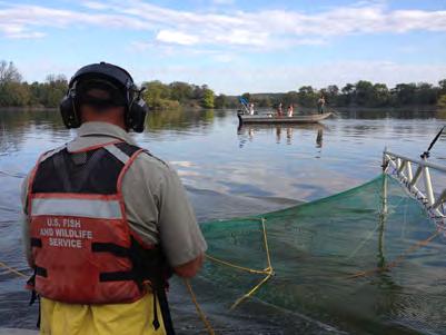
19 Seasonal Intensive Monitoring in the CAWS 2016 Plan Participating Agencies: IDNR (lead), INHS, USFWS, and USACE (field support), USCG (waterway closures when needed), USGS (flow monitoring and dye tracking when needed), MWRD (waterway flow management and access), USEPA and GLFC (project support) ADDITIONAL INFORMATION - Link to mapping tool - Link to 2015 Interim Summary Report Location: Seasonal intensive monitoring will take place in the CAWS upstream of the Electric Dispersal Barrier. Introduction and Need: Detections of Asian carp edna upstream of the Electric Dispersal Barrier in 2009 initiated the development of a monitoring plan using boat electrofishing and contracted commercial fishers to sample for Asian carp at five fixed sites upstream of the barrier. In addition, random area sampling began in 2012 in order to increase the chance of encountering Asian carp in the CAWS beyond the designated fixed sites. Based on the extensive sampling performed upstream of the Electric Dispersal Barrier from 2010 through 2013 (682 hours of electrofishing, km (277 mi) of gill/trammel net, 2.2 km (1.4 mi) of commercial seine hauls) and only one Bighead Carp being collected in Lake Calumet in 2010, fixed site and random area sampling effort was reduced upstream of the barrier to two Seasonal Intensive Monitoring (SIM) events starting in The reduction of effort upstream of the Electric Dispersal Barrier allows for increased monitoring efforts downstream of the barrier. The increase in sampling downstream of the Electric Dispersal Barrier will focus sampling efforts on the leading edge of the Asian carp population, which will serve to reduce their numbers in this area thus mitigating the risk of individuals moving upstream towards the Electric Dispersal Barrier and Lake Michigan by way of the CAWS. Results from SIM upstream of the Electric Dispersal Barrier will contribute to our understanding of Asian carp abundances in the CAWS and guide conventional gear or rotenone rapid response actions designed to remove Asian carp from areas where they have been captured or observed. Objectives: 1) Remove Asian carp from the CAWS upstream of the Electric Dispersal Barrier when warranted; and 2) Determine Asian carp population abundance through intense targeted sampling efforts at locations deemed likely to hold fish. Status: Seasonal intensive monitoring is a modified continuation of Fixed and Random Site Monitoring Upstream of the Electric Dispersal Barrier and Planned Intensive Surveillance in the CAWS. Methods: A variety of gears will be used during SIM, including pulsed DC-electrofishing, trammel and gill nets, deep water gill nets, a commercial seine and Great Lake pound nets to capture and remove 3
20 Seasonal Intensive Monitoring in the CAWS 2016 Plan any Asian carp present in areas where edna has been found to accumulate. The goal is to complete 150 electrofishing runs and 150 net sets (trammel/gill nets, deep water gill nets) during each two week event. Electrofishing Protocol: All electrofishing will use pulsed DC current and include 1-2 netters (two netters preferred). Locations for each electrofishing transect will be identified with GPS coordinates. Electrofishing transects should begin at each coordinate and continue for 15 minutes in a downstream direction in waterway main channels (including following shoreline into off-channel areas) or in a counter-clockwise direction in Lake Calumet. Electrofishing boat operators may switch the safety pedal on and off at times to prevent pushing fish in front of the boat. Common Carp will be counted without capture and all other fish will be netted and placed in a tank where they will be identified and counted, after which they will be returned live to the water. Schools of young-of-year (YOY) Gizzard Shad < mm (6 in) long will be subsampled by netting a portion of each school encountered and placing them in a holding tank along with other captured fish. Due to similarities in appearance and habitat use YOY Gizzard Shad will be examined closely for the presence of Asian carp and enumerated. Crew leaders should fill in as much information on the data sheets as possible for each station/transect and record the location for the start of each run with GPS coordinates (decimal degrees). Netting Protocol: Contracted commercial fishers will be used for net sampling at fixed and random sites and nets used will be large mesh gill nets that are 3 m (10 ft) deep x 91.4 m (300 ft) long in bar mesh sizes ranging from mm ( in). Locations for each net set will be identified with GPS coordinates. Most sets will be of short duration and include driving fish into the nets with noise (e.g., plungers on the water surface, pounding on boat hulls, or revving tipped up motors). Though longer duration sets, particularly in Lake Calumet, may also be incorporated. In an effort to standardize netting effort, short duration sets will be 15- to 20-minutes long and pounding will extend no further than m (450 ft) from the net. Captured fish will be identified to species and enumerated. Locations of net sets should be recorded with GPS coordinates (decimal degrees). An IDNR biologist will be assigned to each commercial net boat to monitor operations and record data. Fixed and Random Area Sites Upstream of the Electric Dispersal Barrier - (weeks of June 13 th and September 19 th ) The sampling design includes intensive electrofishing and netting at five fixed sites and four random site sampling areas (Figure 1). Random area sampling will exclude areas of the waterway designated as fixed sites. Random sites will be generated with GIS software from shape files of designated random site areas and will be labeled with Lat-Lon coordinates in decimal degrees. 4
. Site 1 Lake Calumet.")
21 Seasonal Intensive Monitoring in the CAWS 2016 Plan Upstream Fixed Site Descriptions and Effort - A description of fixed site locations and sampling effort targets is summarized below. The duration of each electrofishing run will be 15 minutes and length of each net set will be m (600 ft). Site 1 Lake Calumet. Sampling will be limited to shallower areas north of the Connecting Channel (this avoids deep draft areas with steep walls but includes channel drop off areas that exist north of the Connecting Channel). Site 2 Calumet/Little Calumet River from T.J. O Brien Lock and Dam to its confluence with the Little Calumet River South Leg ~11.3 km (7 mi). Figure 1. Fixed site and random site sampling areas for electrofishing and commercial netting upstream of the Electric Dispersal Barrier. 5
22 Seasonal Intensive Monitoring in the CAWS 2016 Plan Site 3 Chicago Sanitary Ship Canal (CSSC) and South Branch Chicago River from Western Avenue upstream to Harrison Street ~6.4 km (4 mi). Site 4 North Branch Chicago River and North Shore Channel from Montrose Avenue north to Peterson Avenue ~3.2 km (2 mi). Site 5 North Shore Channel from Golf Road north to Wilmette Pumping Station ~3.2 km (2 mi). Upstream Random Site Sampling Area Descriptions and Effort - A description of random sampling areas and sampling effort targets is summarized below. As with fixed sites, the duration of each electrofishing run will be 15 minutes and length of each net set will be m (600 ft). Four random areas have been identified to facilitate coordination with fixed site sampling (Figure 1). Area 1 Lake Calumet Connecting Channel and Calumet River Area 2 Cal-Sag Channel from its confluence with the CSSC to the Little Calumet River Area 3 CSSC from Western Avenue downstream to the Electric Dispersal Barrier Area 4 North Shore Channel (between Fixed Site 4 and 5), North Branch Chicago River, and Chicago River Lake Calumet, Calumet River and Random Area Sites Upstream of the Electric Dispersal Barrier - (week of June 20 th ) Lake Calumet - Prior to sampling, crews will set Great Lake pound nets at the entrance to Lake Calumet to prevent fish immigration/emigration (Figure 2). This will, however, be contingent on water conditions as flows in and out of Lake Calumet prevented pound nets from being set in Commercial seining will occur in the North section for two days, then in the South section for one day (Figure 2). 6

23 Seasonal Intensive Monitoring in the CAWS 2016 Plan Figure 2. Sampling locations in Lake Calumet. Sample locations are approximate and subject to change. Commercial gill/trammel nets and deep water gill nets will be fished in Lake Calumet, Calumet Connecting Channel and Calumet River. Gill and trammel nets will be set for short duration and will have fish driven into the nets with noise as described above. Deep water gill nets may be set for longer duration. They will be well marked with buoys when left unattended, with IDNR law enforcement officers securing the area. Agency electrofishing crews will operate throughout the monitoring event. Samples will be collected 15 minutes at a time, enumerating catches of fish netted. Electrofishing may also be used in conjunction with commercial fishers to move fish into nets. In conjunction with sampling efforts in Lake Calumet and the Calumet River, electrofishing and gill/trammel netting will also take place at four random site sampling areas throughout the CAWS upstream of the Electric Dispersal Barrier as mentioned above (Figure 1). 7
24 Seasonal Intensive Monitoring in the CAWS 2016 Plan North Shore Channel, Chicago River and Random Area Sites Upstream of the Electric Dispersal Barrier - (week of September 26 th ) North Shore Channel - Sampling will occur between the Argyle Street Bridge, located just downstream from the North Shore Channel and North Branch Chicago River confluence, and the Wilmette Pumping Station (Figure 3). Teams will begin at the upper and lowermost site boundaries and work toward the middle. Each team of two electrofishing boats and one net boat will work together to set nets across the channel and drive fish to nets with electrofishing and noise from pounding on the hull of boats and revving trimmed up motors. Each team will set three nets across the channel at intervals of to m (500 to 800 yds) apart, after which electrofishing and noise to drive fish will occur between the nets. The net closest to the outer site boundary will then be pulled and reset to m (500 to 800 yds) closer to the site center and the process repeated. To maximize sampling time, electrofishing will begin in the area between the remaining nets while the outer net is being moved. The idea is to leapfrog the nets after each electrofishing and fish driving episode so that each team gradually moves toward the site midpoint. Chicago River and South Branch Chicago River/Bubbly Creek - Electrofishing will occur around the entire shoreline of the basin between Lake Shore Drive and Chicago Lock and near Wolf Point (confluence of the North Branch Chicago River and Chicago River) (Figure 3). During this time net boats will set deep water gill nets (IDNR will provide one 9.1 m (30 ft) deep gill net for each net boat) in areas off of the main navigation channel. Nets will be set for short duration and attended at all times. Noise from pounding on the hull of boats and revving trimmed up motors will be used to drive fish into the nets. Electrofishing boats will also be used to drive fish into the nets. When sampling in these areas is complete crews will travel down river and sample eight barge slips and backwater areas in the South Branch Chicago River near Bubbly Creek (Figure 3). Barge slip sampling will have a block net set at the entrance of each slip. Electrofishing boats will then shock from the back of the slip out towards the main channel, driving fish into the block net while collecting stunned fish along the way. A second net may be set midway within longer slips to sample them more effectively. 8

25 Seasonal Intensive Monitoring in the CAWS 2016 Plan Figure 3. Sampling locations in the North Shore Channel, Chicago River and South Branch Chicago River/Bubbly Creek area. In conjunction with sampling efforts in the North Shore Channel and Chicago River, electrofishing and gill/trammel netting will take place at four random site sampling areas throughout the CAWS upstream of the Electric Dispersal Barrier as mentioned above (Figure 1). For all SIM activities accurate sampling time will be recorded with all fish identified to species. GPS coordinates (decimal degrees) will be taken at the location of all net sets and at the beginning of electrofishing runs. Grass Carp will be kept and put on ice for transfer to Dr. Greg 9
26 Seasonal Intensive Monitoring in the CAWS 2016 Plan Whitledge (SIU) for ploidy analysis. Any Bighead Carp or Silver Carp collected will immediately be reported to the Operations Coordinator and/or Law Enforcement who will bring a cooler to secure fish. GPS location, time, and specific gear will be recorded as accurately as possible (mesh size, type, depth). Any Asian carp will be transferred to Dr. John Epifanio, with tissues shared among research agencies as per the 2016 MRP. Furthermore, capture of a Bighead Carp or Silver Carp would initiate a level two rapid response upon conferring with MRWG members, additional effort or time frame could change Sampling Schedule: Spring Event Week of June 13 th Fixed and random area sites upstream of the Electric Dispersal Barrier Week of June 20 th Lake Calumet, Calumet River and random area sites upstream of the Electric Dispersal Barrier Fall Event Week of September 19 th Fixed and random area sites upstream of the Electric Dispersal Barrier Week of September 26 th North Shore Channel, Chicago River and random area sites upstream of the Electric Dispersal Barrier Deliverables: Results for SIM will be reported daily during events and compiled for monthly sampling summaries. Data will be summarized for an annual interim report and project plans updated for annual revisions of the MRP. 10
27 Strategy for edna Monitoring in the CAWS and Temporal edna Quantification Below the Electric Dispersal Barrier Lead Agency: U.S. Fish and Wildlife Service CAWS Monitoring Objectives 1. Monitor Asian carp DNA in strategic locations in the CAWS to potentially inform status of Asian carp. 2. Detect Asian carp DNA in areas that have been monitored since 2009 to maintain annual data collection which may inform other work in the CAWS. ADDITIONAL INFORMATION - Link to mapping tool - Link to 2015 Interim Summary Report Below the Electric Dispersal Barrier Quantification Objectives: 1. Detect and quantify Asian carp DNA in the pools below the electric dispersal barrier from lower Lockport Pool to upper Dresden Island Pool and portions of the Kankakee River above the dam at Wilmington, IL (Figures 1-4). This will complement other field efforts being conducted below the barrier, and may inform control or management actions in the future. USFWS FWCOS will be responsible for the field collection of edna samples and the Whitney Genetics Lab will be responsible for processing samples. All samples will be collected and processed according to the 2016 QAPP. Only the CAWS results will be posted to this site: CAWS monitoring details: One event in June 2016; 240 samples. Each sample will consist of five, 50-mL centrifuge tubes which will be processed in the lab as a single sample. Similar to 2015 MRP, edna will not be used as a trigger for rapid response actions. edna results will be communicated to the IL DNR as soon as they are available, and then posted on the USFWS edna webpage per our communication protocol. A summary of all 2016 edna results will be made available to the MRWG at the end of the year. Table 1. CAWS Sites and number of samples to be collected. SITE DESCRIPTION # SAMPLES North Shore Channel downstream from the Wilmette Pump Station 60 Chicago River downstream from Chicago Lock 60 Little Calumet River downstream from TJ O Brien Lock 60 Lake Calumet 60 Total

28 Strategy for edna Monitoring in the CAWS and Temporal edna Quantification Below the Electric Dispersal Barrier Below electric dispersal barrier details: Two events in 2016 will occur pre- and post-spawn. Prespawn sampling will be conducted when water temperatures are below 18 C and post-spawn sampling will occur later in the summer during lower flow conditions, and avoid any midsummer rising hydrograph events that may trigger additional spawning activity. During each event, samples will be collected using a 95% detection probability at minimum (i.e. 10 samples per 0.3 km 2 ). Each sample will consist of five, 50-mL centrifuge tubes which will be processed in the lab as a single sample. Table 2: Sites and number of samples to be collected below the electric dispersal barrier. SITE DESCRIPTION # SAMPLES Lower Lockport Pool (0.59 km 2 ) 50 Brandon Road Pool (1.10 km 2 ) 50 Dresden Island Pool (2.91 km 2 ) 100 Kankakee River above first barrier (0.75 km 2 ) 25 Total 225 Figure 1. Portion of lower Lockport Pool to be sampled for Asian carp edna in


29 Strategy for edna Monitoring in the CAWS and Temporal edna Quantification Below the Electric Dispersal Barrier Figure 2. All of Brandon Road Pool will be sampled for Asian carp edna in Figure 3. Upper portion of Dresden Island Pool to be sample for Asian carp edna in

30 Strategy for edna Monitoring in the CAWS and Temporal edna Quantification Below the Electric Dispersal Barrier Figure 4. Portion of the Kankakee River, above the Wilmington dam, to be sampled for Asian carp edna in Deliverables: Results of the CAWS sampling event will be reported as positive/negative for sampling summaries. Data will be summarized for an annual interim report and project plans updated for annual revisions of the MRP. Results from the events below the electric dispersal barrier events will be reported as positive/negative and will be summarized for an annual interim report, but will not be posted online. 14
 Participating Agencies: INHS (lead), Eastern Illinois University (field and laboratory support) ADDITIONAL INFORMATION - Link to mapping tool - Link to 2015")
31 Larval Fish Monitoring in the Illinois Waterway Steven E. Butler, Matthew J. Diana, Scott F. Collins, David H. Wahl (Illinois Natural History Survey) Robert E. Colombo (Eastern Illinois University) Participating Agencies: INHS (lead), Eastern Illinois University (field and laboratory support) ADDITIONAL INFORMATION - Link to mapping tool - Link to 2015 Interim Summary Report Location: Larval fish sampling will take place at 10 sites in the Illinois and Des Plaines Rivers downstream of the electric dispersal barrier (LaGrange, Peoria, Starved Rock, Marseilles, Dresden Island, and Brandon Road pools) and at two sites in the CAWS upstream of the electric dispersal barrier (Figure 1). Larval fish sampling will also occur at sites in the Sangamon, Spoon, Mackinaw, Fox, and Kankakee Rivers to assess potential Asian carp spawning in tributaries to the Illinois River. Sites may be dropped, or additional sites added, as needed to complete the study objectives. Figure 1. Map of larval fish sampling sites in the Illinois Waterway (circles) and in tributary rivers (triangles). 15
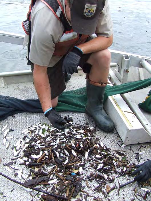
32 Larval Fish Monitoring in the Illinois Waterway Introduction and Need: Factors affecting the early life stages of fish strongly influence recruitment to adult populations. An evaluation of Asian carp reproduction and recruitment in different sections of the Illinois Waterway is needed to better understand Asian carp population dynamics in this system and potentially develop management strategies targeting early life stages. Asian carp eggs are semibuoyant and drift in river currents for approximately a day before hatching. Larvae settle in backwaters, creeks, and flooded areas outside of the main channel, which serve as nursery areas. Prior to 2015, larval and juvenile Asian carp had been collected only in the Alton, LaGrange, and Peoria pools of the Illinois River, and the potential for Asian carp reproduction in upstream reaches of the Illinois Waterway was unknown. Observations of eggs, larvae, and juveniles in the upper Illinois River during 2015 indicate that some reproduction and potential recruitment occur above Starved Rock Lock and Dam in some years, but the contribution of these fish to the population and the frequency of such occurrences remain uncertain. Reproduction and recruitment are known to be highly variable among years in the Illinois Waterway, but factors influencing this variation are still poorly understood. The potential for Asian carp reproduction in smaller tributary rivers is also unknown, but the presence of early life stages in these systems would have important implications for Asian carp control strategies in the Illinois River and elsewhere, particularly in Great Lakes tributaries. Information on the spatial and temporal distribution of Asian carp eggs and larvae will help to identify adult spawning areas, determine reproductive cues, and characterize relationships between environmental variables and survival of young Asian carp. Objectives: We are sampling fish eggs and larvae in the Illinois Waterway and its tributaries to: 1) Identify locations and timing of Asian carp reproduction in the Illinois Waterway; 2) Monitor for Asian carp reproduction in the CAWS; and 3) Determine relationships between environmental variables (temperature, discharge, and habitat type) and Asian carp reproduction and recruitment. Status: During 6 years of sampling (2010 to 2015), 3,252 ichthyoplankton samples have been collected from main channel and backwater sites of the Illinois Waterway, capturing more than 165,000 individual larval fish. Prior to 2015, Asian carp larvae had been collected only at sites in the LaGrange and Peoria pools. However, during 2015 sampling, numerous Asian carp eggs were collected in the Starved Rock and Marseilles pools and three Asian carp larvae were identified in a sample from the Dresden Island pool. The numbers of eggs and larvae collected from throughout the Illinois Waterway during 2015 were also considerably higher than in any previous study year, suggesting that environmental conditions may have been more suitable for successful spawning during Subsamples of presumed Asian carp eggs and larvae were sent to the USFWS Whitney Genetics Laboratory and the USGS Upper Midwest Environmental Sciences Center for genetic confirmation. These analyses identified one of the larvae collected in the Dresden Island pool as a Silver Carp (the other two specimens were not tested because of the destructive nature of the testing), and all but one presumed Asian carp egg (determined to be 16
33 Larval Fish Monitoring in the Illinois Waterway Grass Carp) as either Silver Carp or Bighead Carp. Overall, 94 percent of all presumed Asian carp eggs and 100 percent of all Asian carp larvae that were submitted for genetic analyses were confirmed to be Hypophthalmichthys spp. Asian carp appear to have had multiple spawning events in 2015, as indicated by the timing and location of Asian carp eggs and larvae. Asian carp eggs were first observed at main channel sites in the LaGrange pool during mid-may, after water temperatures had reached approximately 20 C and following a small rise in the hydrograph, but sampling during late May did not detect any Asian carp eggs or larvae at any sites. Following a rapid rise in water levels in early June, extremely high numbers of Asian carp eggs were collected at multiple sites as far upstream as the Marseilles pool, with the highest densities observed in the Starved Rock and Peoria pools. Shortly thereafter, large numbers of Asian carp larvae were collected at all sites in the LaGrange pool, with lower numbers found in the lower Peoria pool. Three Asian carp larvae (8.5 to 10.0 mm TL; developmental stages 41 to 43) were identified in a sample collected upstream of the I-55 bridge in the Dresden Island pool on June 18. Asian carp eggs continued to be collected in the upper Peoria and Starved Rock pools and larvae in the LaGrange and lower Peoria pools through early July. Ichthyoplankton sampling continued to occur throughout the Illinois Waterway through October, but no Asian carp eggs or larvae were collected at any site after July 9. No Asian carp eggs were collected upstream of the Marseilles pool during 2015, and no Asian carp larvae were collected upstream of the Dresden Island pool. Methods: At all Illinois Waterway sampling sites, larval fish samples will be collected using a 0.5 meter-diameter ichthyoplankton push net with 500 µm mesh. To obtain each sample, the net will be pushed upstream using an aluminum frame mounted to the front of the boat. Boat speed will be adjusted to obtain 1.0 to 1.5 m/s water velocity through the net. Flow will be measured using a flow meter mounted in the center of the net mouth and will be used to calculate the volume of water sampled. Fish eggs and larvae will be collected in a meshed tube at the tail end of the net, transferred to sample jars, and preserved in 90 percent ethanol. Four larval fish samples will be collected at each mainstem and backwater site on each sampling date. Sampling transects will be located on each side of the river channel, parallel to the bank, at both upstream and downstream locations within each study site. Three samples will be collected at tributary sites (Sangamon, Spoon, and Mackinaw Rivers) on each sampling date, one near each bank and another in the center of the channel. Boat-mounted push nets will be used at boatable locations, whereas passive drift nets (0.45 x 0.25 meter, 500 µm mesh) will be used at sites where boat access is restricted. Push net sampling will be conducted as for main channel sites, whereas passive drift nets will be deployed for 30- to 180-minute durations, depending on stream flow. Quatrefoil light traps will be used as a supplementary sampling gear along channel margins and in slack-water areas at all tributary sites. Chemical light sticks will be used to attract larval fishes into the traps, and light traps will be set during overnight hours. In 2016, sampling will also be expanded to the lower Fox and Kankakee Rivers to determine if Asian carp reproduction occurs in these systems. Ichthyoplankton sampling in these rivers will be conducted using boat- 17
34 Larval Fish Monitoring in the Illinois Waterway mounted push nets. In the laboratory, fish eggs and larvae will be separated from other materials, and all larval fish will be identified to the lowest possible taxonomic unit. Fish eggs will be separated by size, with all eggs having a membrane diameter larger than 4 mm identified as potential Asian carp eggs and retained for later genetic analysis. Larval fish densities will be calculated as the number of individuals per m 3 of water sampled. Sampling Schedule: In 2016 and subsequent years, larval fish sampling will occur at approximately biweekly intervals at all sites from April to October. Sampling will occur more frequently during periods when Asian carp eggs and larvae are likely to be present (during May and June, during periods of rising water levels, or shortly after peak flows). Deliverables: Results of each sampling event will be reported for monthly sampling summaries. Data will be summarized and project plans updated for annual revisions of the MRP. 18
35 Distribution and Movement of Small Asian Carp in the Illinois Waterway 2016 Plan Participating Agencies: USFWS Carterville Fish and Wildlife Conservation Office Wilmington Substation (lead), USFWS Columbia Fish and Wildlife Conservation Office (field support) ADDITIONAL INFORMATION - Link to mapping tool - Link to 2015 Interim Summary Report Location: Known populations of adult Asian carp exist in all pools of the IWW downstream of Brandon Road Lock and Dam. In 2015, USFWS personnel surveyed for small Asian carp within the Dresden Island, Marseilles, Starved Rock, Peoria, and La Grange pools. As of January 2016, the farthest upstream juvenile Asian carp ( 300 mm TL) have been recorded was in Moody Bayou (Grundy County) at Illinois River mile These two Silver Carp (168 and 171 mm) were collected on October 22, 2015 (USFWS unpublished data). Introduction: The bigheaded carps referred to as Asian carp include the Silver Carp (Hypophthalmichthys molitrix) and Bighead Carp (H. nobilis) as well as hybrids between these species. Populations of these two introduced aquatic nuisance species are spreading throughout the Mississippi River Basin (Conover et al. 2007, Chapman and Hoff 2011, O Connell et al. 2011). Kolar et al. (2007) rated the probability that Silver Carp and Bighead Carp would spread to previously uncolonized areas as high and assigned this rating a very certain degree of confidence. Asian carp are highly invasive species that have been expanding their range in the U.S. since the early 1980s, when they first appeared in public waters (Freeze and Henderson 1982, Burr et al. 1996). Populations of Asian carp have expanded in part because of their rapid growth rates, short generation times, and dispersal capabilities (DeGrandchamp 2003, Peters et al. 2006, DeGrandchamp et al. 2008). Asian carp exhibit very high reproductive potential and capacity for protracted spawning periods (Garvey et al. 2006). As a result of the high reproductive capacity for both species, Garvey et al. (2006) stated that any successful attempt to exclude or remove individuals will require a massive undertaking targeting young small-bodied fish and adults. Populations of Asian carp have become established in the lower and middle reaches of the Illinois River. Natural resource professionals remain concerned about the potential invasion of these species into the Great Lakes via the upper IWW (Conover et al. 2007). These fish may pose a significant threat to established Great Lakes fisheries by competing with economically and recreationally important species for limited plankton resources (Sparks et al. 2011). Kolar et al. (2007) noted the CSSC as the most probable pathway for Asian carp entry into the Great Lakes. Therefore, the CSSC is critical to stopping Asian carp from expanding their range into Lake Michigan and the Great Lakes (Conover et al. 2007). 19
36 Distribution and Movement of Small Asian Carp in the Illinois Waterway 2016 Plan An Electric Dispersal Barrier operated by the USACE in Lockport pool is intended to block the upstream passage of Asian carp through the CSSC. Laboratory tests have shown the operational parameters used at the barrier are sufficient for stopping large-bodied fish from passing through (Holliman 2009). However, testing of operational parameters using small Bighead Carp (51 to 76 mm TL) revealed these parameters may be inadequate for blocking small fish passage (Holliman 2011). USFWS research showed that Golden Shiner (Notemigonus crysoleucas) can be entrained in barge junction gaps upstream through the electric barrier (Davis et al. 2016). Other USFWS research, using a pair of Dual Frequency Identification Sonar units (DIDSON), showed that small fish (unknown species observed on sonar) are able to move upstream through the Electric Dispersal Barrier (Parker et al. 2013). If Asian carp are present near the barrier, these species may be capable of breaching the electric barrier. As such, there is a critical need to delineate the small Asian carp distribution and demographic characteristics below the barrier. Additionally, there is an ongoing need to understand the reproduction of these species in the IWW so managers might better target small fish for eradication or other future management actions. The purpose of this study is to establish where young Asian carp 300 mm occur in the IWW through intensive, directed fish sampling targeting these life stages. For this study, fish specimens 300 mm TL are considered small fish based on previously published estimates of age-1 and age-2 Bighead Carp (Shrank and Guy 2005) and Silver Carp (Williamson and Garvey 2005). Traditional and novel sampling techniques were used in 2015, including small-mesh fyke nets, DC boat electrofishing, and surface, mid-water, and benthic trawls. Irons et al. (2011) evaluated daytime electrofishing and mini-fyke nets as effective gears for detecting and collecting small Asian carp. These two gears have been shown to provide complementary information when employed in shallow water areas (Ruetz et al. 2007). USFWS sampling data indicate that trawls complement these methods by sampling deeper open water habitats. Status: This effort is a continued MRP project for Sampling conducted in 2015 using mini-fyke nets, surface trawls, paupier trawls, dozer trawls, push trawls, and electrofishing gears produced a total catch of 1,651 Silver Carp 200 mm in the Marseilles, Starved Rock, Peoria, and La Grange reaches of the IWW. Objectives: (1) Determine the distribution, abundance, and age structure of small Asian carp in the middle and upper IWW. (2) Use distribution and abundance data to inform potential management actions to stop small Asian carp entry into the Great Lakes via the Chicago Area Waterway System. 20
37 Distribution and Movement of Small Asian Carp in the Illinois Waterway 2016 Plan Methods: Illinois River sampling for Asian carp ( 300 mm) will begin in April and proceed through October. Sampling effort will be distributed between Starved Rock, Marseilles, Dresden Island, and Brandon Road pools. Marseilles and Dresden Island pools will be sampled for at least eight (Marseilles) and 10 crew weeks (Dresden). Sampling sites will be identified as backwaters, isolated pools, main channel border, side channels, side channel borders, marinas, or tributary mouths. Physical, water quality, and habitat measurements will be recorded at the time of each sampling event. Physical measurements include water depth and Secchi depth. Water quality measurements include temperature, salinity, specific conductance, dissolved oxygen, and ph; these parameters are measured with a YSI Professional Series multi-meter. GPS coordinates will be recorded for all net sets, beginning and end of electrofishing runs, and trawl hauls. All small Bighead Carp, Silver Carp, Grass Carp, and up to 25 Gizzard Shad per sample will be measured and weighed. All Bighead Carp, Silver Carp, and Grass Carp will be harvested after capture, and all small Asian carp will be preserved. Fish not easily identified in the field will be fixed in ethanol for laboratory identification to the lowest possible taxonomic level. All other fish will be counted and released. Sampling effort will be quantified as minutes electrofishing (boat and paupier trawl), net nights (mini-fyke nets), and meters sampled (paupier, dozer, and surface trawls). Electrofishing Daytime electrofishing will be conducted for 15-minute periods in water depths <2 meters deep. Pulsed DC (60 pulses/s) will be used for all electrofishing sampling. Fyke netting Wisconsin-type mini-fyke nets will be set in both single and tandem configurations depending on site characteristics. Single nets will be set with the lead end staked against the shoreline or another obstruction to fish movement. Tandem nets (with leads attached end to end) will be fished in open water areas. Dozer trawl Daytime dozer trawls sample water depths between 0.5 and 2 meters. Trawl lengths will vary dependent on the amount of fishable habitat present. This gear can be electrified or not. A 35 mm mesh net at the opening reduces to 4 mm mesh in the cod end, attached to a 2 meter by 1 meter rigid frame that is mechanically raised and lowered to fish depths of up to 1 meter. The net extends approximately 2.5 meters back as it is pushed off the front of the boat. Paupier butterfly trawl Daytime paupier trawls sample water depths between 0.5 and 3 meters. Trawl lengths will vary, depending on the amount of fishable habitat present. This gear can be 21
38 Distribution and Movement of Small Asian Carp in the Illinois Waterway 2016 Plan electrified or not. This trawl contains one 3.7 meter by 1.5 meter rigid frame on both side of a flat-bottomed boat with 35 mm mesh in the body reducing to 4 mm mesh in the cod. Surface trawl Daytime surface trawls sample water depths 1 meter with minimal flows. Trawl lengths will vary, depending on the amount of fishable habitat present. The 10.7-meter-long surface trawl net has a 35 mm mesh in the body reducing to 4 mm mesh in the cod. Towlines extend 38 meters to floating otter boards that spread the net to approximately a 6.5 meter width. Schedule: February March 2016 Gear preparation, planning field logistics, and crew scheduling April October 2016 Fish sampling, fish aging, and data entry October December 2016 Complete fish identification and aging, data entry, and verification December 2016 January 2016 Data analyses, prepare report and presentation Deliverables: An annual MRWG report and presentation will be provided during the winter of 2016 and Any small bigheaded carp captured upstream of Starved Rock pool will be reported immediately to Todd Turner (USFWS Assistant Regional Director Fisheries) or Charlie Wooley (USFWS Deputy Regional Director Region 3) and MRWG. References: Burr, B.M., D.J. Eisenhour, K.M. Cook, C.A. Taylor, G.L. Seegert, R.W. Sauer, and E.R. Atwood Nonnative fishes in Illinois waters: What do the records reveal? Transactions of the Illinois State Academy of Science 89: Chapman, D.C., and M.H. Hoff Introduction in D.C. Chapman and M.H. Hoff, editors. Invasive Asian Carps in North America. American Fisheries Society, Symposium 74, Bethesda, Maryland. Conover, G., R. Simmonds, and M. Whalen, editors Management and control plan for bighead, black, grass, and silver carps in the United States. Asian Carp Working Group, Aquatic Nuisance Species Task Force, Washington, D.C. 190 pp. Davis, J.J., P.R. Jackson, F.L. Engel, J.A. Zinger, R.N. Neeley, S.T. Finney, and E.A. Murphy Entrainment, retention, and transport of freely swimming fish in junction gaps between commercial barges through lock structures and the Electric Dispersal Barrier system on the Chicago Sanitary and Ship Canal. Journal of Great Lakes Research. In review. DeGrandchamp, K.L Habitat selection and movement of Bighead Carp and Silver Carp in 22
39 Distribution and Movement of Small Asian Carp in the Illinois Waterway 2016 Plan the lower Illinois River. Master s Thesis. Southern Illinois University at Carbondale, Illinois. 47 pp. DeGrandchamp, K.L., J.E. Garvey, and R.E. Colombo Movement and Habitat Selection by Invasive Asian Carps in a Large River. Transactions of the American Fisheries Society 137: Freeze, M. and S. Henderson Distribution and status of the Bighead Carp and Silver Carp in Arkansas. North American Journal of Fisheries Management 2: Garvey, J.E., K.L. DeGrandchamp, and C.J. Williamson Life History Attributes of Asian Carps in the Upper Mississippi River System. ERDC/TN ANSRP-06- November Holliman, F.M Determination of optimum performance parameters for electric barriers on the Chicago Ship Canal: a pilot study April Report by Smith-Root, Inc. Holliman, F.M Operational protocols for electric barriers on the Chicago Sanitary and Ship Canal: Influence of electrical characteristics, water conductivity, fish behavior, and water velocity on risk for breach by small silver and bighead carp. Report by Smith Root, Inc. Irons, K.S., G.G. Sass, M.A. McClelland, and T.M. O Hara Bigheaded Carp Invasion of the La Grange Reach of the Illinois River: Insights from the Long Term Resource Monitoring Program. Pages in D.C. Chapman and M.H. Hoff, editors. Invasive Asian Carps in North America. American Fisheries Society, Symposium 74, Bethesda, Maryland. Kolar, C.S., D.C. Chapman, W.R. Courtenay, Jr., C.M. Housel, J.D. Williams, and D.P. Jennings Bigheaded carps: a biological synopsis and environmental risk assessment. American Fisheries Society, Special Publication 33, Bethesda, Maryland. O Connell, M.T., A.U. O Connell, and V.A. Barko Occurrence and Predicted Dispersal of bighead carp in the Mississippi River system: development of a heuristic tool. Pages in D.C. Chapman and M.H. Hoff, editors. Invasive Asian Carps in North America. American Fisheries Society, Symposium 74, Bethesda, Maryland. Parker, A.D. et al Preliminary results of fixed DIDSON evaluations at the electric dispersal barrier in the Chicago Sanitary and Ship Canal. Department of the Interior, U.S. Fish and Wildlife Service, Carterville Fish and Wildlife Conservation Office, 11 pp. Peters, L.M., M.A. Pegg, and U.G. Reinhardt Movements of adult radio-tagged bighead carp in the Illinois River. Transactions of the American Fisheries Society 135: Ruetz III, C.R., D.G. Uzarski, D.M. Kruger, E.S. Rutherford Sampling a littoral fish 23
40 Distribution and Movement of Small Asian Carp in the Illinois Waterway 2016 Plan assemblage: comparison of small-mesh fyke netting and boat electrofishing. North American Journal of Fisheries Management 27: Shrank, S.J., and C.S. Guy Age, growth and gonadal characteristics of adult bighead carp, Hypophthalmichthys nobilis, in the lower Missouri River. Environmental Biology of Fishes 64: Sparks, R.E., T.L. Barkley, S.M. Creque, J.M. Dettmers, and K.M. Stainbrook Occurrence and Predicted Dispersal of bighead carp ion the Mississippi River system: development of a heuristic tool. Pages in D.C. Chapman and M.H. Hoff, editors. Invasive Asian Carps in North America. American Fisheries Society, Symposium 74, Bethesda, Maryland. Williamson, C.J., and J.E. Garvey Growth, fecundity, and diets of newly established Silver Carp in the Middle Mississippi River. Transactions of the American Fisheries Society 134:
41 Fixed Site Monitoring Downstream of the Dispersal Barrier 2016 Plan Participating Agency: IDNR (lead); USACE and USFWS (field support) Location: Monitoring will take place in the CSSC, lower Des Plaines River, and upper Illinois River. Specifically, we will sample the Lockport Pool downstream of the Dispersal Barrier and the Brandon Road, Dresden Island, and Marseilles pools. ADDITIONAL INFORMATION - Link to mapping tool - Link to 2015 Interim Summary Report Introduction and Need: Standardized sampling can provide useful information to managers tracking population growth and range expansion of aquatic invasive species. Information gained from regular monitoring (for example, presence, distribution, and population abundance of target species) is essential to understanding the threat of possible invasion upstream of the Electric Dispersal Barrier. For this project, we use pulsed- DC electrofishing, hoop and minnow fyke netting, and contracted commercial fishers to sample for Asian carp in the four pools below the Electric Dispersal Barrier. A goal of this monitoring effort is to identify the location of the detectable population front of advancing Asian carp in the Illinois Waterway and track changes in distribution and relative abundance of leading populations over time. The detectable population front is defined as the farthest upstream location where multiple Bighead or Silver Carp have been captured in conventional sampling gears during a single trip or where individuals of either species have been caught in repeated sampling trips to a specific site. Monitoring data from 2010 to 2015 have contributed to our understanding of Asian carp abundance and distribution downstream of the Electric Dispersal Barrier and the potential threat of upstream movement toward the CAWS. Based on data collections from 2010 to 2015, sampling efforts upstream of the Electric Dispersal Barrier will continue with the two seasonal intensive monitoring (SIM) events in June and September to allow an increase in sampling efforts downstream of the Electric Dispersal Barrier. This plan of effort will allow the opportunity to better assess Asian carp abundances and distributions downstream of the Electric Dispersal Barrier. Objectives: Standardized sampling will consist of DC electrofishing, hoop and minnow fyke netting, and contracted commercial netting to: 1) Monitor for the presence of Asian carp in the four pools below the Electric Dispersal Barrier; 2) Determine relative abundance of Asian carp in locations and habitats where they are likely to congregate; 3) Supplement Asian carp distribution data obtained through other projects (such as the Asian Carp Barrier Defense Project); and 25
42 Fixed Site Monitoring Downstream of the Dispersal Barrier 2016 Plan 4) Obtain information on the non-target fish community to help verify sampling success, guide modifications to sample locations, and assist with detection probability modeling and gear evaluation studies. Status: This project began in 2010 and is ongoing. Samples were collected at four fixed sites in each of the four pools once monthly from April through November 2010 and from March through November 2011, 2012, and 2013, and twice monthly in 2014 and 2015 with pulsed-dc electrofishing gear. Samples were also collected from July through September 2010, April through November 2011, March through November 2012, March through December 2013, April through December 2014, and March through December 2015 with trammel and gill nets. In total, 12,911 estimated person-hours of labor were expended to complete 549 hours of electrofishing, deploy 923 km of trammel/gill net from 2010 to 2015, and 460 hoop nets and 272 minnow from 2012 to No Bighead or Silver Carp have been captured by electrofishing or netting in Lockport and Brandon Road pools, although one adult Bighead Carp was observed in Brandon Road Pool by a net crew in October Monitoring indicated higher abundance of Bighead and Silver Carp in Marseilles pool than Dresden Island pool. For more detailed results, see the 2015 interim summary report document (MRRWG 2015). Methods: In 2016, fixed and random electrofishing effort will remain the same. Commercial netting effort will have an additional third commercial fisher each week, and fixed and random sites will no longer be used. The commercial fisher will choose the location of each sample based on the likelihood it will yield fish targeted sampling. SIM events will take place in the CAWS in June and September. During those 2 months, contracted commercial fishing efforts will target locations above the Electric Dispersal Barrier. The sample design includes intensive electrofishing and hoop and mini-fyke netting at four fixed sites and target sampling for commercial netting effort in each of the four pools below the Electric Dispersal Barrier (Figure 1). Fixed and random site electrofishing will take place biweekly from March through November. Contracted commercial netting will take place biweekly from March through December, except during June and September. An additional change to the contracted commercial fishing plan is to have the fisherman fish for a predetermined number of hours with no minimum yardage; each fisherman will fish in a different pool each day. The fixed sites in each of the four pools are located primarily in the upper ends below lock and dams structures and in habitats where Asian carp are likely to be located (backwaters and sidechannels). Random electrofishing and contracted commercial fishing sites could occur anywhere within each pool, including the lower portion of each pool. The Kankakee River, from the Des Plaines Fish and Wildlife Area boat launch downstream to the confluence with the Des Plaines River, are included in the Dresden Island pool random sites. Hoop and minnow fyke netting will take place at four fixed sites in each pool on a monthly schedule from April through November. 26

43 Fixed Site Monitoring Downstream of the Dispersal Barrier 2016 Plan No sampling at fixed sites is planned for January or February because several of the sites are typically ice covered during these months. Figure 1. Map of fixed sites for electrofishing and commercial net sampling for Asian carp downstream of the Electric Dispersal Barrier. Fixed Sites Downstream of the Dispersal Barrier Description and Effort: A description of fixed site locations and sampling effort targets is summarized below. There are four 15-minute electrofishing runs, eight hoop net nights with 6-foot diameter hoop nets, and four mini-fyke net nights planned for each of the four pools. Fixed sites will no longer be used for commercial trammel/gill netting. Lockport Pool (1) (1) Fixed Electrofishing Site 1 starts at the Romeo Road Bridge on the east side of the canal and goes downstream (1) Fixed Electrofishing Site 2 starts at the north end of the large haul slip of Hanson Material Services on the west side of the canal and goes downstream (1) Fixed Electrofishing Site 3 starts at the upstream end of the MWRD Controlling Works and goes downstream 27
44 Fixed Site Monitoring Downstream of the Dispersal Barrier 2016 Plan (1) Fixed Electrofishing Site 4 starts at the Rt. 7 Bridge on the west shore and goes downstream (1) Hoop and Mini-Fyke Site 1 is in the big haul slip of Hanson Material Services (1) Hoop and Mini-Fyke Site 2 is upstream of Rt. 7 Bridge on the west side of the canal (1) Hoop and Mini-Fyke Site 3 is just downstream of the Rt. 7 Bridge on the west side of the canal (1) Hoop and Mini-Fyke Site 4 is just downstream of Cargill Grain Elevator on the west side of the canal Brandon Pool (2) (2) Fixed Electrofishing Site 1 is in the bay below the Lockport Hydropower Plant (2) Fixed Electrofishing Site 2 starts just above the confluence of the CSSC and Des Plaines River and goes downstream (2) Fixed Electrofishing Site 3 starts just above the confluence of the Des Plaines River and the Illinois Michigan Canal and goes up the canal (2) Fixed Electrofishing Site 4 starts at the I-80 Bridge and goes downstream along the east shore (2) Hoop and Mini-Fyke Site 1 is just downstream of the confluence of the Des Plaines River (2) Hoop and Mini-Fyke Site 2 is at the confluence of the Illinois Michigan Canal (2) Hoop and Mini-Fyke Site 3 is just downstream of I-80 on the east shoreline (2) Hoop and Mini-Fyke Site 4 is between I-80 and the Brandon Road Lock & Dam Dresden Island Pool (3) (3) Fixed Electrofishing Site 1 is in the bay on east side of river below the Brandon Road Dam (3) Fixed Electrofishing Site 2 starts at the lower end of Treats Island and goes up into the side channel (3) Fixed Electrofishing Site 3 is in Mobil Oil Corporation Cove (3) Fixed Electrofishing Site 4 starts at I-55 Bridge on southeast shoreline and goes downstream (3) Hoop and Mini-Fyke Site 1 is in the bay on east side of river below the Brandon Road Dam (3) Hoop and Mini-Fyke Site 2 is downstream of the casino on the west side of the river (3) Hoop and Mini-Fyke Site 3 is in the lower end of the Treats Island side channel (3) Hoop and Mini-Fyke Site 4 is in Mobil Oil Corporation Cove 28
45 Fixed Site Monitoring Downstream of the Dispersal Barrier 2016 Plan Marseilles Pool (4) (4) Fixed Electrofishing Site 1 is along the west side of Big Dresden Island (4) Fixed Electrofishing Site 2 is along the east shoreline across form Big Dresden Island (4) Fixed Electrofishing Site 3 is at the back end of the north portion of Peacock Slough Fixed Electrofishing Site 4 is in the south portion of Peacock Slough (4) Hoop and Mini-Fyke Site 1 is just upstream of the mouth of Aux Sable Creek (4) Hoop and Mini-Fyke Site 2 is at the mouth of the Commonwealth Edison Co. Cove (4) Hoop and Mini-Fyke Site 3 is just inside the north portion of Peacock Slough (4) Hoop and Mini-Fyke Site 4 is in the back of the south portion of Peacock Slough Electrofishing Protocol - All electrofishing will use DC current and include one to two netters (two netters preferred). Locations for each electrofishing transect will be identified with GPS coordinates. Electrofishing transects should begin at each coordinate and continue for 15 minutes in a downstream direction in waterway channels (including following the shoreline into off-channel areas) or in a clockwise direction in backwater sloughs. Fixed site sampling locations will remain the same throughout the year and should be sampled with each site visit. This approach represents a change from past years, when exact sampling areas within the sites were left to the discretion of the field crews and should lead to more consistent monitoring results. While electrofishing, operators may switch the safety pedal on and off at times to prevent pushing fish in front of the boat and increasing the chances of catching an Asian carp. All fish will be netted and placed in a tank where they will be identified, counted, and check for floy tags, after which they will be returned live to the water. Periodically, a subsample of 10 fish of each species per site will be measured in total length and weighed to provide length-frequency data for gear evaluations. Schools of young-of-year gizzard shad <6 inches (152.4 mm) long will be subsampled by netting a portion of each school encountered and placing them in a holding tank along with other captured fish. Young-of-year shad will be examined closely for the presence of Asian carp and counted to provide an assessment of young Asian carp in the waterway. We will count all captured Asian carp, as well as those observed but not netted. We may observe more Asian carp than we net because of the difficulty in capturing these fish with electrofishing gear. Sample data sheets are included in Appendix F. Crew leaders should fill in as much information on the data sheets as possible for each station/transect and record the location for the start of each run either with GPS coordinates (decimal degrees preferred) or by marking on attached maps. Netting Protocol Contracted commercial fishers will be used for net sampling at targeted sites. Large mesh (3.0 to 4.0 inches (76.2 to mm)) trammel or gill nets 8 to 10 feet (2 to
46 Fixed Site Monitoring Downstream of the Dispersal Barrier 2016 Plan meters) high and in lengths of 200 yards (182.9 meters) will be used for sampling efforts. Locations for each net set will be selected by the commercial fisher and the attending IDNR biologist will mark the location with a GPS coordinates. Sets will be of short duration and include driving fish into the nets with noise (plungers on the water surface, pounding on boat hulls, or racing tipped up motors). In an effort to standardize netting effort, sets will be 15 to 20 minutes long and fish driving will extend no further than 150 yards (137.2 meters) from the net. Nets will be attended at all times. Captured fish will be identified to species and tallied on standard data sheets. Periodically, a subsample of 10 fish of each species per site will be measured in total length and weighed. Locations of net sets should be recorded with GPS coordinates (decimal degrees preferred) or by marking on attached maps. An IDNR biologist or technician will be assigned to each commercial net boat to monitor operations and record data. Single hoop nets will be deployed by IDNR biologists at four locations in the Lockport, Brandon Road, Dresden Island, and Marseilles pools, where they will be fished for 2 days each month. Specific set locations will vary, but nets typically will be set off shore, in current, and parallel to the navigation channel. Four mini-fyke nets will be set at four locations in each of the four pools and fished for one net-night per month. Mini-fyke nets will be set in shallow off-channel areas with leads affixed to the shoreline and running perpendicular to shore. Though hoop and minifyke nets will be left unattended, care will be taken to set them in locations that will not interfere with commercial navigation or recreational boat traffic. Suggested boat launches for fixed site sampling. Lockport Pool Cargill Launch Inform Martin Castro of MWRD. Brandon Road Pool Ruby Street Launch in Joliet on the west side of the river. Dresden Island Pool Big Basin Marina under the I-55 Bridge on north side of the river. Marseilles Pool Stratton State Park Launch in Morris on the north side of the river. Sampling Schedule: A tentative sampling schedule for electrofishing and netting for 2016 is shown in the table below. Hoop and mini-fyke netting will occur monthly, either the week before or after the week of scheduled electrofishing and netting. 30
47 Fixed Site Monitoring Downstream of the Dispersal Barrier 2016 Plan Table 1: 2016 Fixed Site Monitoring Schedule Electrofishing Downstream of Barrier Contracted Netting Below Barrier Fixed Site Hoop and Mini-Fyke Week Agency Week Agency Week Agency Netting Below Barrier 4-Apr INDR/USACE 14-Mar IDNR 1-Aug IDNR Week Agency 25-Apr USFWS/USACE 4-Apr IDNR 15-Aug IDNR 4-Apr IDNR 2-May IDNR 25-Apr IDNR 29-Aug IDNR 23-May IDNR 9-May USACE 23-May IDNR 5-Sep IDNR 13-Jun IDNR 23-May USFWS/USACE 6-Jun IDNR 19-Sep IDNR (SIM) 25-Jul IDNR 6-Jun IDNR/USACE 13-Jun IDNR (SIM) 26-Sep IDNR (SIM) 29-Aug IDNR 13-Jun SIM 20-Jun IDNR (SIM) 3-Oct IDNR 19-Sep IDNR 20-Jun SIM 4-Jul IDNR 17-Oct IDNR 3-Oct IDNR 27-Jun USFWS/USACE 25-Jul IDNR 31-Oct IDNR 28-Nov IDNR 11-Jul IDNR/USACE 28-Nov IDNR 25-Jul USFWS/USACE 15-Aug IDNR/USACE 29-Aug USFWS/USACE 19-Sep SIM 26-Sep SIM 17-Oct IDNR/USACE 31-Oct USFWS/USACE 21-Nov IDNR/USACE Deliverables: Results of each sampling event will be reported for weekly sampling summaries. Data will be summarized for an annual interim report and project plans updated for annual revisions of the MRP. 31
48 REMOVAL PROJECTS AND EVALUATION
49 Response Actions in the CAWS 2016 Plan Participating Agencies: IDNR (lead); INHS, USFWS, and USACE (field support), USCG (waterway closures when needed), USGS (flow monitoring and dye tracking when needed), MWRD (waterway flow management and access), USEPA and GLFC (project support) Location: Rapid response removal actions will take place in the CAWS upstream of Brandon Road Lock and Dam. ADDITIONAL INFORMATION - Link to mapping tool - Link to 2015 Interim Summary Report Introduction and Need: Preventing Asian carp from gaining access to Lake Michigan via the CAWS requires monitoring to detect and locate potential invaders and removal efforts to reduce population abundance and the immediate risk of invasion. Removal actions that capture or kill Asian carp once their location is known may include the use of conventional gears (e.g., electrofishing, nets, and commercial fishers), experimental gears (e.g., Great Lake pound nets, and deep water gill nets), and chemical piscicides (e.g., rotenone), or all strategies. Decisions to commence removal actions, particularly rotenone actions, often are difficult due to high labor, equipment, and supply costs. Furthermore, a one-size-fits-all formula for rapid response actions is not possible in the CAWS because characteristics of the waterway (e.g., depth, temperature, water quality, morphology, and habitat) are highly variable. A threshold framework for response actions with conventional gear or rotenone was developed in the 2011 MRRP. Proposed thresholds were meant to invoke consideration of removal actions by the MRWG, and were not intended to be rigid triggers requiring immediate action. Final decisions to initiate response actions and the type and extent of each action were ultimately based on the best professional judgment of representatives from involved action agencies. Objectives: The plan objectives are: 1) Remove Asian carp from the CAWS upstream of Brandon Road when warranted; and 2) Determine Asian carp population abundance through intense targeted sampling efforts at locations deemed likely to hold fish. Status: Response actions to capture and remove Asian carp from the CAWS began in February 2010 and will continue as needed. Historically, only two Bighead Carp have been collected in the CAWS. These fish were collected in 2009 and 2010 respectively. Since 2010, an estimated 21,533 person-hours were expended monitoring fixed and random sites in the CAWS upstream of the Electric Dispersal Barrier. Total effort was hours. 32
50 Response Actions in the CAWS 2016 Plan EF (hrs) Netting (mi) Figure 1. Total electrofishing and trammel/gill netting effort at fixed and random sites in the CAWS upstream of the Electric Dispersal Barrier, of electrofishing (3,486 transects), 599 km (372.2 mi) of gill/trammel net (3,140 sets), 6 km (3.7 mi) of commercial seine hauls and 41.2 net-days of hoop and trap nets (15 sets) from The use of hoop nets and trap nets was suspended after 2013 due to low gear efficiency. A total of 314,763 fish representing 71species and 3 hybrid groups have been sampled since Gizzard Shad, Common Carp, Bluegill, Largemouth Bass, Bluntnose Minnow, Pumpkinseed were the predominant species sampled, accounting for 77% of all fish collected. Since 2010, 17 non-native species have been caught, which include Common Carp and Common Carp x Goldfish hybrids, Alewife, Goldfish, White Perch, Round Goby, Oriental Weatherfish, Threadfin Shad, Rainbow Trout, Grass Carp, Brown Trout, Chinook Salmon, Coho Salmon, Tilapia, Rainbow Smelt, Silver Arrowana and Threespine Stickleback. Non-native species constitute 14% of the total fish caught and 24% of the total species. Banded Killifish, a state threatened species, have been routinely collected during our monitoring efforts in the CAWS. To date, 1,323 Banded Killifish have been sampled at fixed and random sites upstream of the Electric Dispersal Barrier. No Bighead Carp or Silver Carp were captured or observed in the CAWS upstream of the Electric Dispersal Barrier from One Bighead Carp was caught in a trammel net in Lake Calumet in Furthermore, 99,314 YOY Gizzard Shad have been examined since 2010 with no YOY Asian carp being identified. Effort in 2015 was 106 hours of electrofishing (422 transects) with an estimated 990 personhours, 74.4 km (46.2 mi) of trammel/gill netting (441 sets), 2.2 km (1.4 mi) of commercial seine and 4 tandem trap nets, with an estimated 1,125, 135 and 30 person-hours utilized, respectively. Across all locations and gears, 35,728 fish representing 60 species and 2 hybrid groups were 33
51 Response Actions in the CAWS 2016 Plan sampled in Gizzard Shad, Common Carp, Freshwater Drum and White Sucker were the predominant species, comprising 66% of all fish sampled. Thirteen non-native species were also sampled, which included Common Carp and Common Carp x Goldfish hybrids, Round Goby, Alewife, Goldfish, White Perch, Oriental Weatherfish, Grass Carp, Threadfin Shad, Chinook Salmon, Coho Salmon, Tilapia and Rainbow Trout. Non-native species made up 21% of the total species collected and 17% of the total fish in Two hundred seventeen (217) Banded Killifish, a state threatened species, were also collected. They were identified and returned to the water alive. No Bighead Carp or Silver Carp were captured or observed during SIM in 2014 or In addition, we examined 11,535 YOY Gizzard Shad and found no YOY Asian carp. Methods: We will use radio telemetry, conventional gears, experimental gears and/or rotenone to locate, capture and remove Asian carp from the CAWS upstream of Lockport Lock and Power Station. Each response action will be unique to location, perceived severity of the threat, and likelihood of successfully capturing an Asian carp. For example, observation of a live Asian carp from a credible source at the shallow North Shore Channel might elicit a 2- to 3-day conventional gear response with two electrofishing and netting crews. Capture of a live Asian carp at the same location might initiate a 2-week response with 5-10 sampling crews and additional types of gear. Furthermore, capture or credible observations of multiple Asian carp in a deep-draft channel, such as the Little Calumet River below O Brien Lock, might call for an emergency rotenone action to eradicate the local population. In general, small-scale removal actions will require fewer sampling crews and gear types than larger events, although all events will include multiple gears for more than one day of sampling and participation by commercial fishers, if available. New methods to drive, capture, and kill Asian carp are constantly being developed and evaluated as part of the ACRCC Framework (see water gun, gear evaluation, and alternative gear projects in this plan). Such techniques may allow biologists to drive or attract Asian carp to barge slips or other backwater areas where they can be captured more easily or killed. We will incorporate new technologies in response actions when they have been sufficiently vetted and shown to be of practical use. Threshold Framework- Data from ECALS has revealed the uncertainty of edna positive detections originating from a live, free swimming fish, and several vectors have been identified as potential sources in addition to a live fish. Intensive sampling over the several years, including response actions triggered by detection of Asian carp DNA, has resulted in no Asian carp being observed or captured. At present, the detection of edna evidence within a sampled reach cannot verify whether live Asian carp are present, whether the DNA may have come from a dead fish, or whether water containing Asian carp DNA may have been transported from other sources such as boat hulls, storm sewers, sediment, piscivorous birds or nets used by contracted commercial fishers. It is also not fully understood how environmental variables (e.g. temperature, conductivity, ph, etc.) 34
52 Response Actions in the CAWS 2016 Plan impact the detection rate, degradation rate, or persistence of DNA in the environment. In light of this information, the MRWG proposes this framework to guide management decisions on response actions in the CAWS where edna is no longer a response trigger. Therefore, the observation, capture or a detection of a radio tagged live Asian carp by a credible source would be triggers for initiating a response. The proposed thresholds for response actions with conventional gears and rotenone apply to monitoring efforts from the CAWS upstream of Brandon Road Lock and Dam. Again, this threshold framework is meant to inform decisions to initiate response actions and guide the level of sampling effort put forth during such actions. Actual decisions to respond and the type, duration, and extent of response actions will be made by agency representatives with input from the MRWG. Action agencies also may conduct targeted response actions at selected locations in the CAWS outside the rapid response threshold framework when information gained from such actions may benefit monitoring protocols, research efforts, or Asian carp removal and control efforts. The threshold framework includes three levels of response triggers and a feedback loop that advises for continued sampling or an end to the action (Figure 2). The first threshold level (Level 1) includes the observation of live Asian carp by a credible source (i.e., fisheries biologist or field technician). A suggested response for Level 1 might include 2-4 electrofishing boats and crews and 1-2 commercial fishing boats and crews sampling for 2-3 days. A Level 2 threshold Level 2 Response 4-6 electrofishing boats and crews 3-5 commercial fishing boats and crews Additional gear employed Duration = up to 10 days 2 or more AC Level 2 Threshold Capture of a single live bighead or silver carp 1 AC 1 AC 2 or more AC No AC Level 3 Threshold Capture of two or more live Asian carp at one location/sampling event or Observation of two or more live Asian carp at one location Level 1 Response 2-4 electrofishing boats and crews 1-2 commercial fishing boats and crews Duration = 2-3 days No AC Response edna Action Ends No AC Level 3 Response Initiate Level 2 response and Consider rotenone action Level 1 Threshold Observation of live AC by credible source RotenoneAction Figure 2. Thresholds for Asian carp (AC) response actions with conventional gears and rotenone. 35
53 Response Actions in the CAWS 2016 Plan would include the capture of a single live Bighead Carp or Silver Carp. A Level 2 response might employ 4-6 electrofishing boats and crews, 3-5 commercial fishing boats and crews, and additional gears (e.g., hydroacoustics, commercial seines, and trap or fyke nets). Level 2 events might last up to 10 days. The capture of two or more Asian carp from a single sampling eventlocation or the credible observation of two or more Asian carp at one location would signify a Level 3 threshold. Crossing the Level 3 threshold would trigger an immediate Level 2 conventional gear response action and consideration of a rotenone response. Where feasible (e.g., non-navigation reaches, barge slips, backwater areas), block nets will be used in an attempt to keep Asian carp in the area being sampled. The final decision to terminate a response will rely on best professional judgment of participating biologists, managers, and agency administrators. Sampling Schedule: Response actions will be dependent upon the credible observation, capture and radio tagged detections of live Asian carp and recommendations from the MRWG. Deliverables: Results for each removal action will be reported daily during events and compiled in monthly sampling summaries. Data will be summarized for an annual interim report and project plans updated for annual revisions of the MRP. Also contingency planning for the upper Illinois Waterway has been developed for future responses (Appendix X). The contingency efforts were developed in light of additional information of small fish downstream within Starved Rock Pool and possible small fish barge entrainment scenarios. The contingency plan will be supplement this response plan as needed. 36
54 Barrier Maintenance Fish Suppression 2016 Plan Participating Agencies: IDNR (lead); INHS, USFWS, USACE and USGS (field support); USCG, USEPA, and MWRD (project support) ADDITIONAL INFORMATION - Link to mapping tool - Link to 2015 Interim Summary Report Location: Sampling to assess abundance of Asian carp may take place in the Lockport Pool of the CSSC between Lockport Lock and Power Station and the Electric Dispersal Barrier system (RM ). Surveillance methods using both hydroacoustic and sonar-based surveys will occur between the demonstration barrier and Barrier 2A to assess initial abundances between the Electric Dispersal Barrier. Traditional and novel techniques will then be deployed in cooperation or after the aforementioned surveillance technologies to clear fish from between the barriers. The work area will be extended about 0.25 mile (0.4 km) in both upstream and downstream directions if a backup rotenone action is necessary to allow for chemical application and detoxification stations. Introduction and Need: The USACE operates three electric dispersal barriers (Demonstration Barrier, Barrier 2A, and Barrier 2B) for aquatic invasive species in the CSSC at approximate River Mile near Romeoville, Illinois. The Demonstration Barrier is located farthest upstream (800 feet (243.8 m) above Barrier 2B and is operated at a setting that has been shown to repel adult fish. Barrier 2A is located 220 feet (67.1 meters) downstream of Barrier 2B, and both of these barriers now operate at parameters that have been shown to repel fish as small as 3.0 inches (76.2 mm) long in the laboratory (Holliman 2011). Barrier 2A and 2B must be shut down for maintenance approximately every 6 months, and the IDNR has agreed to support maintenance operations by providing fish suppression at the barrier site. Fish suppression can vary widely in scope and may include application of piscicide (rotenone) to keep fish from moving upstream past the barriers when they are shut down. This was the scenario for a December 2009 rotenone operation completed in support of Barrier 2A maintenance, which was before Barrier 2B was constructed. With Barrier 2A and 2B now operational, fish suppression actions will be smaller in scope because one barrier can remain on while the other is taken down for maintenance. The Demonstration Barrier, Barrier 2B and Barrier 2A have previously been operated with the Demonstration Barrier in continuous operation and only Barrier 2B or Barrier 2A in concurrent operation. Beginning in January 2014, the Electric Dispersal Barrier system received approval to operate all three barriers concurrently to increase redundancy in the event of an unplanned shutdown. With this barrier operation protocol, IDNR will lead fish surveillance and suppression at the barrier whenever the barrier s system experiences a planned or unplanned shutdown that creates an opportunity for fish passage in the upstream direction. Based on 3 years of conventional fish sampling and edna monitoring in the CAWS upstream and downstream of 37
55 Barrier Maintenance Fish Suppression 2016 Plan the Dispersal Barrier, fish suppression is necessary because there is a possibility that Asian carp could be present throughout this reach of the waterway. Fish passage opportunities may occur when the farthest downstream active barrier experiences a loss of power in the water, allowing fish to move upstream to the next active barrier. Those fish may then be entrained between two electric fields until the next upstream barrier allows passage during an outage or they are flushed downstream. This scenario creates an unacceptable level of risk that Asian carp could gain access to the upper CAWS and Lake Michigan and reduces the redundancy that is considered an essential feature of the entire barrier system. The intent is to drive fish below the barrier system after repairs or maintenance have been completed and normal operations have been resumed. The following is a generalized plan to provide fish suppression at the barriers in support of barrier maintenance. Operations to clear fish may take from 1 to 5 days and may include any combination of traditional and novel collecting and driving techniques and, if necessary, a smallscale rotenone action. A plan is also included for intensive fish sampling to detect presence and assess abundance of Asian carp that may be in the canal immediately downstream of the barrier. By selecting a cut-off of 300 mm in total length for physical fish removal, sub-adult and adult Asian carp are targeted. Excluding young-of-year Asian carp from the requirement of physical removal is based on more than 3 years of sampling in the Lockport pool with no indication that any young of the year Asian carp are present or any known location of spawning. However, continued monitoring in the lower reaches of the Illinois Waterway in the spring of 2015 indicated that small Asian carp less than 153 mm were being collected progressively upstream over time. Juvenile Silver Carp were reported from the Starved Rock pool beginning in April in substantial numbers with several individual captures of similar sized juvenile Silver Carp reported from the Marseilles pool by October. These new records prompted resource managers to take a more conservative approach at the barriers by sampling all sizes of fishes between the barriers during a clearing event. It was determined that all fishes over 300 mm still be physically removed from the area and that fishes less than 300 mm be sub-sampled to ensure no juvenile or young of year Asian carp are present. A key factor to any response is risk of Asian carp being at or in the barrier. The MRWG (Monitoring and Response Workgroup) has taken a conservative approach to barrier responses in that there is little evidence that Asian carp are directly below the barrier, but with the understanding that continued work and surveillance below the electric barriers is necessary to maintain appropriate response measures. With budgetary costs, responder safety, and surveillance findings in mind, the MRWG will direct response needs based on best professional judgment. A barrier maintenance clearing event will be deemed successful when all fish >300 mm in total length are removed from the barrier or until MRWG deems the remaining fish in the barrier as a low risk and physical capture and identification has been made on an appropriate number of fishes <300 mm in total length. 38
56 Barrier Maintenance Fish Suppression 2016 Plan Objectives: The IDNR will work with federal and local partners to: (1) Remove fish >300 mm (12 inches) in total length between Barrier 2A and 2B before maintenance operations are initiated at Barrier 2B or after maintenance is completed at Barrier 2A by collecting or driving fish into nets from the area with mechanical technologies (surface noise, surface pulsed-dc electrofishing, and surface to bottom gill nets) or, if needed, a small-scale rotenone action. (2) Assess fish assemblage <300 mm (12 inches) in total length between Barriers 2A and 2B for species composition to ensure Asian carp juvenile or young of year individuals are not present. Physical capture gears focused on small-bodied fishes such as electrified paupier surface trawls and surface pulsed-dc electrofishing could be utilized in support of this effort. (3) Assess the results of fish clearing operations by reviewing the physical captures and surveying the area between Barriers 2A and 2B with remote sensing gear (split-beam hydroacoustics and side-scan sonar). The goal of fish clearing operations is to remove as many fish (>300 mm in total length) as possible between the barriers, as determined with remote sensing gear or until the MRWG deems the remaining fish in the barrier as a low risk. Fishes <300 mm in total length at the barriers are deemed a low risk to be Asian carp until further evidence from downstream monitoring suggests the presence of this size class upstream of Brandon Road Lock and Dam. Status: Fish suppression in support of barrier maintenance began in 2009 and is ongoing. One multi-agency fish clearing action occurred in An estimated 104 person-hours were spent sampling in the dispersal barrier during the barrier maintenance event. Effort for each gear at the maintenance event was 1.5 hours of surface pulsed-dc electrofishing, 45 minutes of electrified paupier surface trawls, 1 hour of hydroacoustics transects, and 2,300 yards ( meters) of surface to bottom gill nets. Across all gears, a total of 51 fish representing 11 species were collected. The clearing action was taken on 18 and 19 November 2015 and included two surface, pulsed DC electrofishing boats (USACE Chicago District and IDNR), one electrified, pulsed DC paupier trawling boat (USFWS Columbia), one side-scan sonar boat (USFWS Wilmington), and two deep water gill net boats (IDNR/Contracted Fishermen). Two IDNR contracted commercial fishing vessels deployed deep gill nets within the Lower Lockport pool downstream of the Electric Dispersal Barriers. The USFWS Columbia crew performed three mid-channel, open water runs with a discreet deployment between Barriers IIA and IIB. The IDNR electrofishing crew performed three 15-minute electrofishing surveys along both canal walls in the area between Barriers IIA and IIB in conjunction with the USACE/USFWS electrofishing crew. No Asian carp were captured or identified in the effort. After physical clearing methods, a crew from the Carterville FWCO Wilmington Substation conducted an acoustic survey using a pair of side-looking 200 khz split-beam transducers and a 1600 khz side-scan sonar system at the Electric Dispersal Barrier system. The survey focused on 39
57 Barrier Maintenance Fish Suppression 2016 Plan the area between the Barrier IIA narrow array and the Barrier IIB narrow array. Five replicate survey transects were conducted. Results of the survey suggested that fish density between the two barriers was very low (0.832 fish/1,000m 3, SD = 0.166). No fish track targets had estimated lengths > 150 mm based on target strength returns. For more detailed results of fish clearing and sampling relative to barrier maintenance, see the 2015 interim summary report document (MRWG 2016) and the Monitoring Asian Carp Population Metrics and Control Efforts plan. Methods: Project Overview Our current approach to fish suppression at the barrier is to first survey the area with remote sensing gears to assess the need for fish clearing operations, either in support of planned barrier maintenance or after an unplanned power loss. If any number of fish >300 mm in total length are present, then mechanical collection or driving techniques will be used to move fish downstream out of the target area. A request for no flow conditions will be made to MWRD for a 2-hour period during surveillance and clearing operations. If mechanical clearing fails and there is a high risk for Asian carp to be in the barrier, response actions may be elevated to a small-scale rotenone action to clear fish from the area. Finally, a plan is included for intensive sampling in the Lockport pool downstream of the barrier to further measure the risk of an Asian carp presence at the barrier during maintenance. If downstream sampling suggests an increased risk for juvenile or young-of-year Asian carp presence at the barriers, clearing and driving methods will be used for all sizes of fish if present between the barriers. Remote Sensing and Mechanical Clearing Operations - Surveys will be conducted with splitbeam hydroacoustics and side-scan sonar to determine if fish are present in the target area and to evaluate the success of mechanical fish clearing actions. Clearing will be considered successful when no fish larger than 300 mm are observed between the barriers or the MRWG deems the remaining fish in the barriers as a low risk. By selecting a cut-off of 300 mm, fish targets will be limited to sub-adult and adult Asian carp while excluding young-of-year. Excluding young-ofyear Asian carp from the assessment is appropriate because there is no indication of their presence in the Lockport pool based on more than 3 years of intensive monitoring. Continued monitoring in the lower reaches of the Illinois Waterway in the spring of 2015 indicated that small Asian carp less than 153 mm were being collected progressively upstream over time as far north as River Mile within the Marseilles pool near Seneca, Illinois. These new data were reviewed in 2015 by the MRWG and it was suggested to continue with a clearing action if fish of any size were detected between the barriers by remote sensing methods. Fish less than 300 mm would need to be confirmed as non-asian carp species to be considered a successful clearing event. Multiple surveys are necessary to enhance confidence in results that fish are either present or absent from the area between the barriers. The principal remote sensing tools are split-beam 40
58 Barrier Maintenance Fish Suppression 2016 Plan hydroacoustics and side-scan sonar. These gears are operated simultaneously and provide about 98 percent coverage of the waterway with just three passes of the barrier area (10- to 15-minute survey duration; see 2014 Barrier Maintenance Fish Suppression final report in MRWG 2014). A request will be sent to the Metropolitan Water Reclamation District of Greater Chicago (MWRDGC) to reduce or halt canal flows during a typical maintenance shutdown, and then remote sensing gears will be deployed to survey the target area. The detection of fish of any size within the target area will initiate mechanical suppression actions. Mechanical suppression will target removal of all fishes greater than 300 mm and identify an appropriate sub-sample of fishes less than 300 mm. Activities will begin with surface pulsed-dc electrofishing in conjunction with noise generation to drive fish from the area and may include additional clearing techniques such as electrified paupier trawls, complex noise, or other experimental fishing gear in the designated safety zone area. Figure 1 provides a map and description of a mechanical fish clearing operation at the dispersal barrier. A second set of surveys will occur after mechanical removal operations have taken place with both barriers operational to assess the effectiveness of mechanical removal efforts. It is beneficial to have low flow conditions during remote sensing surveys to reduce interference with hydroacoustics scans caused by air bubbles entrained in the water column. Operators at MWRDGC have been helpful in modifying flows to assist with fish clearing operations. The presence of any large juveniles or adult fish (>300 mm) between the barriers that have been determined to be a high risk for Asian carp by the MRWG signifies that a rotenone action will likely be necessary to eliminate fish from the area. In contrast, a planned rotenone action may be cancelled if mechanical suppression is shown to be successful. Canal navigation closures may not be necessary for remote sensing surveys when one barrier is operating (2A or 2B); however, they will be needed for mechanical fish suppression activities. Typically, IDNR will make a request to USCG for safety zone closures to navigation in the vicinity of the barriers for 5 hours each morning (7:00 a.m. to 12:00 p.m.) on 4 to 5 days during the week of barrier maintenance fish clearing. A contingency week should also be planned in case equipment failure or inclement weather precludes operations. All closure requests will be made 45 days prior to a planned event. 41

59 Barrier Maintenance Fish Suppression 2016 Plan Barrier Outage Fish Clearing Methods Site Map A Physical Removal Area Physical removal may include pulsed DC electrofishing, pulsed DC electrified paupier travois, deep water electrofishing vessels, and other novel fishing gear as identified. Physical removal boats arid gear may be deployed in tandem or series, depending on available room to maneuver and fish safely. Fish targets will initially be identified within this area by remote sensing gears. Fish scaring or driving tactics may also be utilized within this area and may include boat pounding, plungers, tipped engines or submerged speakers with complex noise, Netting Area Gill/Trarnmel netting area is located below the southernmost submerged Barriers infrastructure and south of the Romeoville Road Bridge. A request for no flow to low flow conditions may be made to the MRWDGC for a 2-hour period during netting operations Safety Procedures Standard safety procedures for working in the barrier area will be followed Two spotters will be located on the east and west bank of the canal, a safety boat with AED will be located below the Romeo Road Bridge Figure 1. Map and descriptions of a fish cleaning operation at the Dispersal Barrier. 42
60 Barrier Maintenance Fish Suppression 2016 Plan Small Scale Rotenone Action - Rotenone is considered the fallback method for fish suppression should other clearing efforts prove to be unsuccessful. If necessary, rotenone will be applied from boats at a location just upstream of the arched overhead pipe that designates the upstream boundary of the barrier Regulated Navigation Area (RNA) Safety Zone enforced by the USCG (Figure 2). This application will create a rotenone slug that will travel downstream and mix throughout the water column, driving fish from the target area between barriers or killing them. The rotenone slug will be detoxified with liquid sodium permanganate pumped from boats at a location south of the Romeo Road Bridge (Figure 2). Unlike fish clearing methods discussed above, the effect of rotenone on fish is well known and has been documented, precluding the need for on-site evaluation. Barrier 2B will be turned down for maintenance once stable operation of Barrier 2A has been confirmed. Although rotenone is an effective technique for controlling fish populations, there are several reasons for attempting physical removal of fish before rotenone is applied. Even the proposed small-scale rotenone action will be costly (estimated $150,000 to $250,000), require extensive labor and permitting (minimum 40 to 50 persons and NEPA, NPDES, IDNR CERP, and Special Local Needs labeling), and require a longer duration canal closure than physical fish clearing (estimated 8 to 10 hours vs. 0 to 5 hours). In addition, barrier maintenance must occur regularly at approximately 6-month intervals. Developing methods that are less expensive and disruptive to canal users is beneficial to all involved stakeholders. In contrast to rotenone, physical clearing methods will not pollute waters or kill fish. Fish killed with rotenone must be collected and disposed of in a USEPA-approved toxic waste landfill. Perceptions that rotenone actions poison the water have been expressed by potential purchasers of commercially harvested Asian carp from down river locations. These perceptions may adversely affect the success of Asian carp commercial market development projects. Furthermore, while rotenone is used and neutralized successfully in most cases, there is the possibility that mechanical or environmental factors could allow rotenone to travel outside of the treatment area, where additional aquatic resources could be unintentionally harmed. Finally, the USACE telemetry program to assess the effectiveness of the barriers will be adversely affected should tagged fish in the vicinity of the barriers be eradicated by rotenone. A small-scale rotenone action will take place if remote sensing surveys indicate fish >300 mm long may be present between Barriers 2A and 2B and mechanical suppression measures fail to collect or drive fish from the area unless MRWG deems the remaining fish in the barrier as a low risk. All operations will occur between Hanson Material Service s large barge slip (River Mile 295.2) and a point approximately 0.25 miles (0.4 km) upstream of the arched pipeline (up to River Mile 297). No work is planned in the designated RNA, although it will be necessary for some boats to pass through the RNA to reach upstream chemical application stations (see Safety and Communication section below for RNA restrictions). IDNR will stand up an Incident Commend Structure (ICS) for a rotenone action and will work closely with USCG and 43
61 Barrier Maintenance Fish Suppression 2016 Plan USACE (possibly in Unified Command) during all phases of project planning and implementation to ensure a safe and successful event. Detailed plans for a rotenone action will be prepared by IC staff, but a general overview of possible operations is presented here. In all, we anticipate a 3 to 4 day operation with 12 to 15 boats, 45 to 50 field crew, and 15 to 20 IC staff and support crew. This estimate does not include security and safety zone enforcement boats and crews. Day 1 will include travel to the site, gear preparation, and collection of sentinel fish for detoxification monitoring. 44

62 Barrier Maintenance Fish Suppression 2016 Plan Figure 2. A map of a small-scale rotenone operation to clear from the Dispersal Barrier. 45
63 Barrier Maintenance Fish Suppression 2016 Plan The bulk of the work will occur on the second day of operations and a 10-hour daytime canal closure will be necessary on this day. During Day 2, we will apply approximately 125 gallons of rotenone from boats (n = 5) located at a station upstream of the RNA. The chemical will be allowed to mix and flow downstream over the barriers, killing fish or forcing them out of the area. Dye will be used to track the leading and trailing boundaries of the rotenone slug. Reactivation of Barrier 2A must be synchronized with the passing of the tail end of the rotenone slug through the barrier area to prevent movement of fish back into the treatment zone. Detoxification with approximately 750 gallons of sodium permanganate applied from boats (n = 3 to 4) will take place downstream of the barrier RNA. The exact location of the detoxification station will be based on consultations with personnel from the Midwest Generation power plant and their level of concern over permanganate entrainment through the plant cooling system. Cages with sentinel fish will be placed at several downstream locations in the Lockport Pool to ensure that detoxification was successful. Although a large kill is not anticipated, we will have two to three recovery boats and crews and one dumpster on hand for the collection and disposal of dead fish. Fish recovery will continue on the third and fourth day of the event, as needed. Lockport Pool Sampling - Fish sampling may take place in the CSSC from Lockport Lock and Power Station to the downstream boundary of the barrier RNA (Figure 3) when deemed necessary by the MRWG. Sampling has been shown to be effective without waterway closures, but closures can be requested if sampling is to take place in the main navigation channel for extended periods of time. An example of sampling gears and anticipated effort from a fall 2010 multi-gear operation is included in the following table and text. All captured fish will be identified to species, counted, and a subsample of 20 fish per species per gear type will be measured (mm total length). Except for Asian carp, all captured fish will be returned live to the waterway. Any captured Asian carp will be held and immediately reported to the operations coordinator. 46
64 Barrier Maintenance Fish Suppression 2016 Plan Methods Boat/crew Number of sets, runs, or samples Duration Pulsed DC-electrofishing 2 boats; 6 crew** 6 hours total; min. per run Commercial fishers - trammel/gill 8 x 600 ; 3-5 in. mesh Experimental gill nets 6 x 300 ; in. mesh 10 x 150 ; in. mesh Mini fyke nets (10) 2 boats; 4 crew, and 2 IDNR observers 1,000 yards (914.4 m) of net set and run/boat/day 1 boat, 3 crew* 6 nets set overnight in off channel areas 2 partial days; three 30-min. runs/boat/day 2 nights; hour set 1-2 nights; hour set 1 IDNR boat, 3 crew** 10 nets set overnight 2 partial days; hour set Telemetry 1 boat, 4 crew NA 1-2 days *Same boat doing different sampling. Figure 3. Lockport Pool downstream of the Dispersal Barrier showing target areas for fish sampling operations. Sampling will require eight open deck aluminum boats that range in size from 18 to 24 feet (5.5 to 7.3 m) long. The staging, boat launch, and overnight boat storage area will be located at the 47
65 Barrier Maintenance Fish Suppression 2016 Plan Cargill Launch site on the west bank of the canal just south of the Route 7 (9 th Avenue) Bridge (a/k/a. Carp Camp 1). Mini-fyke nets and experimental gill nets will be fished in shallower, nearshore areas away from the navigation channel and in a portion of Hanson Material Services large slip during day and night hours. Daytime trammel net sets will be of short duration (15 to 20 minutes) and fish will be driven into the nets by pounding, a method commonly used by commercial netters. Short-term sets will always be attended by a net boat crew and target areas throughout the reach known to hold concentrations of fish. Trammel nets may be set overnight in backwater and off-channel areas to increase chances of catching fish. Safety and Communication - Safety is a primary objective when operating in the electric field created by the barrier. Boats will be equipped with required safety equipment and floatation devices. Operators and crews will wear personal flotation devices while working on the water. No work for fish sampling operations is scheduled to take place in or upstream of the barrier RNA. However, all requirements of the RNA will be followed should a crossing be necessary. The RNA extends from the arched pipe downstream to a point 450 feet (137.2 meters) below the Romeo Road Bridge (designated by Sampson post #2 on the west bank). First, any vessel crossing the Dispersal Barrier or entering the RNA will provide advance notification to the Coast Guard Captain of the Port Representative on scene at (630) or VHF-16. Additional RNA requirements include: a. The vessel cannot be less in than 20 feet (6.1 meters) in length. b. The vessel must proceed directly through the RNA and may not conduct any fishing operations, loiter, or moor within the RNA boundaries. Special permits will be requested for remote sensing surveys and mechanical fish suppression operations planned to take place within the RNA (see below). c. All personnel must remain inside the cabin, or as far inboard as practicable. If personnel must be on open decks, they must wear a Coast Guard-approved Type II personal floatation device. The CSSC is a working ship canal, and sampling crews should be aware of potential hazards in the waterway. Note that no boats should operate near barges that are being loaded. In addition to the hazard of being hit by material that misses the target, there are cables that move barges along the wall during loading. These cables may be under the water surface when slack, but can rapidly rise 4 to 5 feet (1.2 to 1.5 meters) above the water when tightened. A rising cable could cause severe bodily injury or catch and easily flip a sampling boat. Crews should be aware of their surroundings and avoid potential safety hazards while sampling. Communication among boats, staff, security, and shore command will be by marine radio or cell phone. A briefing before any crew enters the water will be held and will include a handout of crew leaders and cell phone numbers for each participating boat/crew. This handout will include a map 48
66 Barrier Maintenance Fish Suppression 2016 Plan of the sample reach. All boats will be equipped with numbered flags for identification on the water and hand-held marine radios operating on Channel 12 for the operation, unless emergency communication with USCG or the Lockmaster is necessary (Channel 16, 14). Emergency contact numbers (local ambulance, fire/rescue service, Lockmaster, USGC contact information, and MWRD) will be included on the handout if needed for unforeseen reasons, yet the primary communicator to these services will be the operations coordinator or Incident Commander. Sampling Schedule: Barrier maintenance may be required every 6 months to a year. The USACE determines the need for barrier maintenance and when maintenance will occur. The IDNR has requested that USACE provide a notice of maintenance dates 60 days in advance to allow time for planning and preparation. The USCG requires that Safety Zone applications be submitted 45 days prior to the requested canal closure dates. By law, mariners must be informed about any non-emergency canal closures 30 days before the closure is to occur. Canal closures are required for the safety of mariners and operation crews. Deliverables: Results of fish sampling events will be compiled for monthly sampling summaries. Fish suppression updates will be provided daily during operations. Data will be summarized for an annual interim report and project plans updated for annual revisions of the MRP. 49
67 Barrier Defense Asian Carp Removal Project 2016 Plan Participating Agencies: IDNR (lead) Location: The Barrier Defense Project will target the area between the Starved Rock Lock and Dam up to the Electric Dispersal Barrier at Romeoville. The primary focus area will be the Starved Rock and Marseilles Pools. ADDITIONAL INFORMATION - Link to mapping tool - Link to 2015 Interim Summary Report Introduction and Need: This project uses controlled commercial fishing to reduce the numbers of Asian carp in the upper Illinois and lower Des Plaines Rivers downstream of the Electric Dispersal Barrier. By decreasing Asian carp numbers, we anticipate decreased migration pressure toward the barrier and reduced chances that carp will gain access to upstream waters in the CAWS and Lake Michigan. Trends in harvest data over time may also contribute to our understanding of Asian carp population abundance and movement between pools of the Illinois Waterway. The project was initiated in 2010 and is ongoing using nine contracted commercial fishing crews to remove Asian carp with large mesh (3.0 to 5.0 inch)(76.2 to 127 mm) trammel nets, gill nets and other gears on occasion (such as seines and hoop nets). Objectives: Nine commercial fishers will be employed to: (1) Harvest as many Asian carp as possible in the Starved Rock and Marseilles pools. Harvested fish will be picked up and utilized by private industry for purposes other than human consumption; and (2) Gather information on Asian carp population abundance and movement in the Illinois Waterway downstream of the Electric Dispersal Barrier as a supplement to fixed site monitoring. Status: Contracted commercial fishers and assisting IDNR biologists deployed 1,579.2 miles ( km) of gill and trammel net, 5.3 miles (8.5 km) of commercial seine, and 204 hoop net sets in the upper Illinois Waterway since A total of 79,077 Bighead Carp, 325,096 Silver Carp, and 2,558 Grass Carp were removed by contracted netting. The total weight of Asian carp removed was 1, tons. For more detailed results, see the 2015 interim summary report document (MRRWG 2015). Methods: Contract commercial fishing will take place from March through December. Contract commercial fishing will occur in the target area of Marseilles and Starved Rock pools. This target area is closed to commercial fishing by Illinois Administrative Rule; therefore, an IDNR biologist will be required to accompany commercial fishing crews working in this portion of the river. Six commercial fishing crews per week with assisting IDNR biologists will fish Tuesday through Friday of each week, 1 to 3 weeks each month of the field season. Fishing will 50
68 Barrier Defense Asian Carp Removal Project 2016 Plan occur in backwater areas known to hold Asian carp, main channel, and side channel habitats. Specific netting locations will be at the discretion of the commercial fishing crew with input from the IDNR biologist assigned to each boat. Large mesh (3.0 to 5.0) (76.2 to 127mm) trammel and gill net will be used and typically set 20 to 30 minutes, with fish being driven to the nets with noise (for example, pounding on boat hulls, hitting the water surface with plungers, and running with motors tipped up). Nets will be occasionally set overnight off the main channel and in non-public backwaters with no boat traffic. Biologists will enumerate and record the catch of Asian carp and identify the by-catch to species. Asian carp and common carp will be checked for ultrasonic tags, and ultrasonic tagged fish and by-catch will be returned live to the water. All harvested Asian carp will be removed and transferred to a refrigerated truck and taken to a processing plant, where they will be used for non-consumptive purposes (for example, converted to liquid fertilizer). Each harvest event a representative sample of up to 30 of each Asian carp species (Bighead, Silver, and Grass Carp) from each pool will be measured in total length and weighed in grams to provide estimates of total weight harvested. Suggested Boat Launches for Barrier Defense Harvesting: Marseilles Pool Stratton State Park Launch in Morris on the north side of the river. Starved Rock Pool Allen Park Launch in Ottawa off Route 71 on the south side of the river or Starved Rock Marina off of Dee Bennett Road on the north side of the river. Sampling Schedule: A tentative sampling schedule for 2015 is shown in the table below. Week of Agency Week of Agency Week of Agency March 7 IDNR May 9 IDNR Oct 24 IDNR March 21 IDNR May 16 IDNR Nov 14 IDNR March 28 IDNR May 30 IDNR Dec 5* IDNR April 11 IDNR Jun 27 IDNR April 18 IDNR Aug 22 IDNR May 2 IDNR Sep 12 IDNR * Weather permitting. Deliverables: Results of each sampling event will be reported for weekly sampling summaries. Data will be summarized for an annual interim report and project plans updated for annual revisions of the MRRP. 51
69 Identifying Movement Bottlenecks and Changes in Population Characteristics of Asian Carp in the Illinois River 2016 Plan Participating Agencies: Southern Illinois University-Carbondale (lead), The Ohio State University (support), Western Illinois University (support) Location: This project takes place in the Illinois River, tributaries, and associated backwaters from Dresden pool to Alton pool. ADDITIONAL INFORMATION - Link to mapping tool - Link to 2015 Interim Summary Report Introduction: Recent evidence has suggested that the electric dispersal barrier in the CAWS may not be as effective as once thought to inhibit all fish movement (see for example Parker et al. 2013). Although the risk of an Asian carp breach is currently considered to be low based on the absence of Asian carp in the area of the Electric Dispersal Barrier, harvest of Asian carp downstream of the electric barrier may help to reduce the probability that Asian carp will challenge the barrier during a chance event that could allow them to successfully breach it. However, the extent to which the intensive efforts of Asian carp removal are curtailing the probability of upstream movement is largely unknown. A previously developed Asian carp population model (Tsehaye et al. 2013) provided a reasonable first step at determining the efficacy of Asian carp harvest as a control option. The results from this model suggested an exploitation rate of 70 percent on all sizes of Asian carp (both Bighead and Silver Carp) to overfish the population to functional extinction within the lower three reaches of the Illinois River (Alton, La Grange, and Peoria pools). The results from recent commercial harvest experiments conducted by SIUC suggest that we are not meeting these requirements, at least in terms of size selectivity. Despite the observed size selectivity, field information collected in intensively harvested areas has yielded promising results that are consistent with demographic changes expected to occur in heavily fished populations. Prior studies at SIUC have also shed light on the movement of Asian carp, showing that upstream movement of Asian carp occurs in the spring of each year, with carp moving upstream as far as the Starved Rock pool from the confluence with the Mississippi River. Immigration rates from the Mississippi River to Illinois River were measured at 30 percent in 2010 and up to 57 percent in 2013 (during a flood year). Movement corresponded with elevated flow in the river during spring through summer for all years fish have be monitored with acoustic transmitters. Asian carp that moved upstream typically returned to downstream locations in late summer or early fall. Our most recent data suggest that the probability of Asian carp moving between the Peoria and Starved Rock pools and the Starved Rock and Marseilles pools is relatively low, suggesting that these areas may act as natural barriers to carp movement. However, results from markrecapture studies (prior SIUC reports) suggest that immigration into the Marseilles pool is high 52
70 Identifying Movement Bottlenecks and Changes in Population Characteristics of Asian Carp in the Illinois River 2016 Plan throughout spring, summer, and fall, contributing to a continuous stream of immigrants to that pool. Where these immigrants are coming from and how fish are passing upstream is unclear. There is a need to address the inadequacies of the previous Asian carp population model (Tsehaye et al. 2013) to make it more useful in terms of decision making relative to the spatial allocation of harvest to minimize propagule pressure on the Electric Dispersal Barrier. As such, an updated model is needed that includes necessary spatially explicit components that incorporate empirically derived probability of movement across the entire Illinois River. A more refined model should also make use of all available demographic data that have been, and will be, collected from various sources, including investigating the use of Long Term Resource Monitoring Program (LTRMP) data and other standardized sampling programs to develop stockrecruitment relationships for Bighead and Silver Carp. To inform the population model, additional hydroacoustic surveys need to be completed to measure changes in the Asian carp population with controlled fishing. Additional monitoring of fish densities (via hydroacoustics) and movement is necessary to assess the success of control efforts, advise control efforts, and monitor the progress (invasion front) of Asian carp toward the CAWS. Control efforts of Asian carp are still under way in the Illinois River. Many pertinent questions still need to be answered relative to fish movement because removal could affect density, size, biomass, age structure, and movement of Asian carp throughout the river. Specifically, is movement related to lock and dam structure, leading to a partially isolated population in the upper Illinois River (likely between Peoria and Starved Rock, also Starved Rock and Marseilles)? If so, can this population be further isolated with barrier technology and reduced? Furthermore, if fish are moving through the Starved Rock and Marseilles Lock chambers, which fish are moving (for example, small or large individuals, Bighead or Silver Carp) and when? Finally, hybridization may influence the movement, spawning, and feeding ecology of fish. The degree to which Silver and Bighead Carp are hybridizing throughout the river has implications for the invasibility of the CAWS and the Great Lakes. Thus, continuous monitoring of hybridization rates throughout the Illinois River is necessary. Status: This continued MRP project is ending in spring of Field collections are completed with data analysis and model development remaining. Objectives: Spatially-explicit population model (1) Update reach-specific Asian carp demographic parameter estimates (abundance, age and size distribution, growth, survival, condition, maturation schedule) using Bayesian methodology by spring The predictions from the model will benefit from the additional years of data collection, and a Bayesian approach will provide a more realistic understanding of our uncertainty in model predictions. 53
71 Identifying Movement Bottlenecks and Changes in Population Characteristics of Asian Carp in the Illinois River 2016 Plan (2) Complete refinement of Bighead and Silver Carp stock-recruitment relationships by spring 2016; the uncertainty in the stock-recruitment relationships were found to be the largest source of variation in the Tsehaye et al model. A more refined stockrecruitment relationship will provide a more realistic depiction of how Asian carp populations will respond to intense harvest and reduce the uncertainty related to various harvest strategies evaluated. (3) Develop a spatially-explicit Asian carp population model for the Illinois River waterway that incorporates inter-reach movement probabilities by spring (4) Use the newly developed model to predict the number of Asian carp that would reach the electric dispersal barrier under various harvest scenarios. The results of this modeling endeavor will facilitate management decisions regarding the spatial allocation of harvest to maximize the effectiveness of Asian carp removal efforts. Probability of movement and dam passage telemetry, tagging, and hybridization (1) Use a multi-state model to estimate probabilities of moving among Illinois River pools by spring (2) Evaluate how the probability of movement between Illinois River pools relates to environmental variables (temperature and water level), as well as examine possible density-dependent movement. (3) Measure changes in the rate of Asian carp hybridization throughout the river by genetically identifying up to 50 fish per pool (completed on all fish that are tagged with acoustic transmitters as of July 2014 and some Asian carp collected during standardized sampling). This information will allow us to measure changes in hybridization relative to movement, fish density, commercial fishing (fish reduction), and additional demographic data. Abundance and Demographics (1) Determine the current density, biomass, species composition, and size structure of Asian carp in the Illinois River. This information will allow us to identify natural barriers to movement and inform commercial fishing efforts (such as additional locations of fish congregations). This information will also provide baseline population data necessary for parameterization of the spatially-explicit population model. Population estimates necessary for model parameterization (prior years: 2012 to 2014) will be completed during Additional hydroacoustic surveys were completed in summer/fall of (2) Detect changes in the Asian carp population in response to the ongoing removal efforts in the upper reaches of the Illinois River. This information will allow us to quantify the effect of removal efforts on Asian carp populations in areas of differing densities and provide an additional tool to help locate fish congregations for targeted removal. This effort was completed in summer Methods: Spatially explicit population model Asian carp demographic parameters will be updated using existing Asian carp data from all possible sources (state and federal agencies and universities). Data from the LTRMP and any 54
72 Identifying Movement Bottlenecks and Changes in Population Characteristics of Asian Carp in the Illinois River 2016 Plan other sources with reliable standardized approaches will be used to investigate the development of species-specific stock recruitment relationships. Catch per unit effort data may at the very least facilitate the scaling of stock-recruitment parameters. Additional explanatory variables, such as river discharge, will be evaluated in these relationships to explain additional recruitment variation. If the catch per unit effort data prove inadequate for development of stock-recruitment relationships, an alternative would be to use a similar approach that was used in Tsehaye et al. 2013, but narrow the pool of stocks down to similar species rather than the all-encompassing approach previously used. If this approach is adopted, it will be necessary to explore varying annual recruitment to capture the boom and bust nature of Asian carp recruitment patterns. Similar to the Tsehaye et al model, a Bayesian approach will be used for parameter estimates to allow for incorporation of individual variability and parameter uncertainty in model simulations. Re-parameterization and a refined population model will be applied to each reach of the Illinois River (Alton, La Grange, Peoria, Starved Rock, Marseilles, Dresden, Brandon Road, and Lockport pools) to develop a spatially explicit Asian carp population model. The upper reaches (upstream of the Peoria pool) will be distinct in that adult Asian carp will be assigned a very low probability of successful reproduction such that this rare possibility is at least included in the model for conservative measures. Movement probabilities of Asian carp among all reaches based on empirical data will be incorporated and will likely include other explanatory variables regarding the probability of movement, including size, temperature, and hydrography (see Probability of Movement and Dam Passage). Harvest scenarios evaluated will include, but will not be limited to, (1) a baseline strategy of no harvest, (2) harvest Asian carp from only the upper reaches, (3) harvest of Asian carp from only the downstream reaches, (4) harvest along the entire Illinois River waterway, (5) spatially dynamic strategy in which commercial fisherman are responding to changes in catch rates in an effort to maximize their catch per effort, (6) and an optimization approach that can facilitate an adaptive management approach (in other words, the best place to fish may change seasonally). Other goals would be to define the exploitation levels or target density levels required to minimize movement probabilities of Asian carp to the electric barrier and how size-selectivity influences our results. Other reasonable harvest scenarios will be obtained through discussions with the Illinois Department of Natural Resources. Under each harvest strategy, the probability of Asian carp reaching the Lockport pool will be estimated with confidence bounds based on individual variability, environmental variability, and parameter uncertainty. An odds ratio approach will be adopted to examine the relative improvement of one strategy relative to others. Probability of movement and dam passage-telemetry and tagging Using program MARK, telemetry data collected by SIUC throughout the Illinois River from 2012 to 2015 will be used to parameterize a robust multi-state model that can estimate probabilities of Asian carp transitioning among pools. 55
73 Identifying Movement Bottlenecks and Changes in Population Characteristics of Asian Carp in the Illinois River 2016 Plan Abundance, Demographics, and Hybridization We will use the approaches developed in previous years (2010 to 2014) to determine Asian carp density, biomass, species composition, and size structure in the Illinois River. A combination of side-looking and down-looking hydroacoustics and side-scan sonar techniques will be used to quantify fish targets. Surveys transects will be conducted in main channel, tributaries, side channels, and connected backwater lakes from Dresden Lock and Dam downstream to the purported source of the Asian carp population near the confluence of the Mississippi River. Electrofishing will be conducted by SIUC in the Alton, La Grange, and Peoria pools to inform hydroacoustic surveys and determine the relative species composition, size/age structure, and sex ratio of Asian carp and other species in the lower river. A subsample of Asian carp from each reach of the Illinois River will be retained by SIUC and used for estimation of sex ratio, gonadal condition, and age (with sectioned post-cleithra). Information about fish in the upper reaches will be obtained from multiple ongoing efforts (for example, IDNR subsampling and INHS Havana LTEF sampling). Post-processed hydroacoustic data will be combined with fish sampling data to estimate Asian carp densities, biomass, species composition and size structure. In the upper river, we will undertake hydroacoustic surveys in conjunction with commercial fishing events to assess changes in the Asian carp population. These surveys will be performed in areas of high density (Starved Rock pool), medium density (Marseilles pool), low density (Dresden pool), and possibly in areas of no Asian carp (Brandon Road pool). This approach would allow us to ground truth hydroacoustic estimates and correlate population estimates with harvest catch rates. Hybridization may influence the movement, spawning, and feeding ecology of fish, with implications for invasibility in the CAWS and the Great Lakes. A subset of Asian carp will be vouchered and tissue samples sent to Western Illinois University (J. Lamer), where genetic tests will be used to determine the rate of hybridization. All genotypes will be assigned by posterior probabilities computed by the NewHybrids hybrid assignment algorithm. Resulting products are genetic identities, allele frequencies, and maternal contributions of up to 400 Asian carp per year. Fin clips from up to 50 fish from each pool sampled (all fish tagged with acoustic transmitters) will be analyzed for genetic hybridization. Timeline: The proposed timeline for this project is 2 years (2014 to 2015 and 2015 to 2016). More details about the timeline for each project are outlined in the Objectives. Field work for this project has been completed, with data analysis and model development remaining to be completed in Deliverables: Quarterly reports on progress as available, final report for 2015 to 2016, including all information gathered with conclusions, continuous patterns of movement throughout the entire Illinois River, to enhance movement probability parameters for the overall model, providing a 56
74 Identifying Movement Bottlenecks and Changes in Population Characteristics of Asian Carp in the Illinois River 2016 Plan risk assessment for movement toward the CAWS and Great Lakes in collaboration with the USACE by the end of this project. Possible relationships among Asian carp movement and environmental conditions will be identified, as well as movement probabilities among pools, which may identify movement bottlenecks. This work will also provide annual (2014 and 2015) density and biomass estimates for Asian carp in the Illinois River and comparisons of these estimates through time. This project will also provide a quantitative assessment of the efficacy of removal efforts in the upper reaches of the Illinois River. Literature Cited: Tsehaye I, Catalano M, Sass G, Glover D, Roth B Prospects for fishery-induced collapse of invasive Asian carp in the Illinois River. Fisheries 38:
75 BARRIER EFFECTIVENESS EVALUATION
76 Telemetry Monitoring Plan 2016 Plan Participating Agencies: USACE (lead); ILDNR, SIUC, MWRDGC & USFWS (support) ADDITIONAL INFORMATION - Link to mapping tool - Link to 2015 Interim Summary Report Overview The Asian Carp Regional Coordinating Committee (ACRCC) developed the Asian Carp Control Strategy Framework to protect the Great Lakes from two species of Asian carp present in the Illinois Waterway (IWW). As part of this Framework, the ACRCC formed a subcommittee, the Asian Carp Monitoring and Response Work Group (MRWG), to develop and implement a Monitoring and Response Plan (MRP) for these invasive species. The plan consists of a series of scientific studies to detect, monitor, and respond to the invasion before reproducing populations of Asian carp become established in Lake Michigan. Telemetry has been identified as one of the primary tools to assess the efficacy of the Electric Dispersal Barrier System as well as investigating inter-pool movements and invasion front habitat use. In Summer 2010, an acoustic telemetry sampling strategy was initiated using a network of acoustic receivers supplemented by mobile surveillance to track the movement of tagged Bighead Carp (Hypophthalmichthys nobilis), Silver Carp (H. molitrix), and associated surrogate fish species in the area around the Aquatic Nuisance Species Electric Dispersal Barriers (Barriers) in the Chicago Sanitary and Ship Canal (CSSC) and Upper IWW. This network has been maintained to date through a partnership between the U.S. Army Corps of Engineers (USACE), the U.S. Fish and Wildlife Service (USFWS), the Metropolitan Water Reclamation District of Greater Chicago (MWRD), Southern Illinois University of Carbondale (SIUC) and the Illinois Department of Natural Resources (ILDNR) as part of the MRWG s monitoring plan. Although the telemetry monitoring plan is scheduled as a five year program, it is important to note that a certain level of monitoring should be maintained throughout the life of the Barriers project. This work plan will outline the major goals of the telemetry program and identify key objectives for the 2016 sampling season. Although working estimates are also projected for the 2017 sampling season, these priorities may change based on new information collected by the MRWG in Introduction The telemetry monitoring plan includes the tagging of fish with individually coded ultrasonic transmitters in the Upper IWW. The acoustic network proposed is comprised of stationary receivers and supplemented by a mobile hydrophone unit to collect information from acoustic transmitters (tags) implanted into free-swimming Asian carp (Bighead Carp and Silver Carp) and surrogate species. Acoustic receiver coverage within the Upper IWW is primarily focused at the electric dispersal barriers with secondary coverage surrounding lock and dams and emigration routes such as tributaries and backwater areas. In 2013, the receiver network was expanded to cover the Marseilles Pool in conjunction with SUIC. From the data collected within the Marseilles Pool it was decided 58
77 Telemetry Monitoring Plan 2016 Plan that too few receivers were deployed and a more focused approach would be required to better understand Asian carp habitat use and patterns of movement at the leading edge. This plan recommended shifting that focus to the Dresden Island Pool and the Kankakee River by re-allocating receivers from Marseilles resulting in 28 stationary receivers in In 2015 a total of 31 stationary receivers were placed from the confluence of the Cal-Sag to Dresden Island Lock and Dam and up the Kankakee River near the Wilmington Dam (Figure 1). In 2015, ten tagged Asian carp were detected on the receiver placed at the Wilmington Dam during high flows. As a result, additional receivers will be placed upstream of the Wilmington Dam to determine passage rates of tagged Asian carp and surrogates. Additional receivers will also be placed to increased detectability of Asian carp within the Dresden Island Pool (Figure 1). Since 2010, 143 Asian carp have been collected and tagged from the Dresden Island and Marseilles Pools in the IWW while 404 surrogate species have been collected and tagged from the Lockport and Brandon Road Pools closer to the Barriers. Tagged surrogate fish have been released above and below the Barrier; however, no tagged Asian carp have been released upstream of the previously known leading population front (Brandon Road Lock and Dam; RM 286.0). Tagged fish deployment at the electric dispersal barriers has varied in the species, total length, and deployment methods to account for potential bypass mechanisms identified by outside projects. Potential bypass mechanisms include small fish (less than 4 inches) challenging the barriers as well as barge interactions causing entrainment through the barriers. There have been two observations of tagged fish released below the Barriers which were later detected upstream. These tags were not detected on receivers in proximity to the Barriers however and further investigation suggests that these tags may have been transported by barge entrainment although it has not yet been verified. No fish have been observed to swim through an active electric barrier field in the upstream direction to date. Goals and Objectives The overall goal of this telemetry monitoring plan is to assess the effect and efficacy of the Barrier on tagged fish in the Chicago Area Waterways (CAWS) and Upper IWW using ultrasonic telemetry. The goals and objectives for the 2016 season have been identified as: Goal 1: Determine if fish are able to approach and/or penetrate the electric dispersal barrier system (Barrier Efficacy); Objective Monitor the movements of tagged fish (large and small) in the vicinity of the electric dispersal barrier system using receivers placed immediately upstream and immediately downstream of the barriers. Objective Support fish-barge interaction studies at the Barriers through supplemental data collection of tagged fish in the vicinity during controlled experimental trials 59
78 Telemetry Monitoring Plan 2016 Plan Goal 2: Determine if and how Asian carps and surrogate species pass through navigation locks in the Upper IWW; Objective Monitor the movements of tagged fish at Dresden Island, Brandon Road, and Lockport Locks and Dams using stationary receivers (N=8) placed above and below and within each lock. Goal 3: Determine the leading edge of the Asian carp range expansion; Objective Determine if the leading edge of the Asian carp invasion (currently RM 286.0) has changed in either the up or downstream direction. Objective Describe habitat use and seasonal movement in the areas of the Upper IWW and tributaries where Asian carp have been captured and relay information to the population reduction program undertaken by IDNR and commercial fishermen. Additional objectives of the telemetry monitoring plan: Objective Integrate information between agencies conducting related acoustic telemetry studies. Objective Download, analyze, and post telemetry data for information sharing. Objective Maintain existing acoustic network and rapidly expand to areas of interest in response to new information. Objective Examine seasonal movement and habitat use of Asian carp and other surrogates Work Plan Sample size and distribution Sample size was selected through review of similar studies, past catch data and expert opinion from the MRWG. In 2010, the workgroup decided that a baseline minimum of 200 transmitters be implanted for telemetry monitoring in the vicinity of the electric dispersal barriers and that this level of tags be maintained as battery life expires or specimens exit the study area. At the conclusion of the 2015 sampling season there were 192 live, tagged fish within the study area with varying expiration dates. It is expected that 74 of these transmitters will expire within the 2016 sampling season. Additional tagging will be required to sustain recommended minimum levels of the sampling size. In 2016, additional receivers will be placed throughout the Dresden Island pool to further improve detectability. Specifically, receivers will be placed in the Kankakee, the mouth of the DuPage River, and just upstream of the Kankakee River confluence. In 2015, ten tagged Asian carp were detected at the receiver near the Wilmington Dam resulting in the furthest upstream detection of tagged Asian carp in the Kankakee River. Asian carp have been captured via bow fishermen upstream of the Wilmington Dam, but it may be important to determine the amount of Asian carp traversing the dam and how much of the river are the fish utilizing. To start obtaining a better understanding, two additional receivers will be placed upstream of the Wilmington Dam in One will be placed at 60
79 Telemetry Monitoring Plan 2016 Plan the Kankakee Dam, the next upstream impoundment from Wilmington Dam, and another at an intermediate distance between the two dams. Preliminary investigations suggest that some Asian carp may be utilizing the confluence of the DuPage River. The DuPage River does have a dam near the confluence, but USACE will place a receiver at this location to determine the amount of usage by Asian carp. Finally, a receiver will be placed just upstream of the Kankakee River confluence near Harborside Marina. This area of the river is narrow and represents a natural choke point that will help maximize detections of fish. In addition, this receiver will help understand how often Asian carp are utilizing the Grant Creek bypass channel and provide more detailed information on the movement patterns/paths used during intra-pool migrations. In 2015, depth sensor tags were used in surrogates to further refine how fish behave within and around the Electric Dispersal Barrier and Brandon Road Lock and Dam. The data provided some interesting findings and as a result further use of depth sensor tags will be used in However, these tags will be placed in Asian carp within Dresden Island pool and will also include a temperature sensor on the tag. The use of depth/temperature sensor tags will help further refine habitat usage of Asian carp throughout the Dresden Island pool which may lead to increased rates of harvest. These tags will also help determine what habitat is primarily used during intra-pool migrations observed within the Dresden Island pool. Table 1: Recommended transmitter implementation for the 2016 sampling season. Supplemental tags are required to maintain existing level of coverage within the study area while exact ratios per pool may be changed slightly to account for new focus areas *10 depth/temp sensor tags. Release Pool/Location Species Spring Supplement tags Fall Supplement tags Total estimated tag distribution (1 Jan 2017) Upper Surrogate species Lockport/RM Lower Surrogate species Lockport/RM Brandon Surrogate species Road/RM Dresden Island/RM276 Asian carps 0 10* 82 The proposed distribution of tags across the study area is influenced by several factors including the carrying capacity for the receiver network per pool, the increasing focus and attention on the Brandon Road Lock and available source populations of the target species. All except 29 tags implanted and released prior to 2015 into surrogate fish species within the Lower Lockport pool will have expired by 1 January 2017 and will need to be replaced. Similarly, only 61
80 Telemetry Monitoring Plan 2016 Plan 26 of the tags released prior to 2015 in the Brandon pool will be active through the 2016 sampling season. An additional 76 tagged fish (V16TP and V16) will be added to the Lockport, Brandon and Dresden Island Pools in As in previous years, surrogate species will be used throughout the study area while Asian carps will only be released downstream of the known population front in order to reduce the risk of assisting any upstream advance of the invasive species. Species selection (primary and surrogate) - Asian carps (Bighead and Silver Carp) are the primary species of concern, and their behavioral response to the barriers is of the greatest importance. However, as mentioned previously, populations of both species vary and are considered rare to absent near the Barriers. Therefore, in order to test the direct response of fish and maintain target density levels within all pools, surrogate species have been tagged and monitored within the Dresden Island, Brandon Road and Lockport pools. Dettmers and Creque (2004) cited the use of Common Carp (Cyprinus carpio) as a surrogate species for use in telemetry in the CSSC because Common Carp are naturalized and widespread throughout the CSSC and Illinois water bodies in general. Common Carp are known to migrate relatively long distances and they grow to large sizes that approximate those achieved by invasive carps. Based on these characteristics, tracking of Common Carp should provide a good indicator of how Asian carp would respond to the dispersal barrier if they were in close proximity to this deterrent. These characteristics could also justify the use of other species such as buffalo (smallmouth and black), Grass Carp (another species of Asian carp), and Freshwater Drum. Tagging efforts will continue to utilize fish site fidelity to increase the probability of attempted fish passage through the Electric Dispersal Barrier as well as lock and dams. Results from 2014 and 2015 along with published literature (ACRCC, 2013; Jones and Stuart, 2009) indicate that captured fish display high site fidelity upon release and tend to return to the area of capture. For example, fishes to be released in Lower Lockport pool will be captured upstream of the electric dispersal barriers and tagged and released downstream. These fishes will have a greater propensity to return to their capture site, hence, challenging the barriers more often. This same technique will be employed at the Dresden Island pool with a subset of surrogate fishes captured in the Brandon Road pool. When this technique was first implemented in the 2014 sampling season there had been 176 barrier challenges made between May 2011 and 31-Dec, During 2014, the first year of the modified release, there were 525 barrier challenges between 1-Jan and 31-Oct alone. This practice will continue in 2016 in order to gain a higher resolution of data to support barrier effectiveness and lock passages. While this technique is encouraged with surrogate species to increase the sample size of barrier challenges (dispersal barrier or lock chamber), Asian carps will be tagged and released near their capture location. It is important to remove any bias in experimental design when attempting to describe patterns of habitat use and movement. 62
81 Telemetry Monitoring Plan 2016 Plan Tag specifications and Implantation procedure Tagging efforts will be focused during spring (April-May) and fall (October-November) and will follow the surgical and recovery procedures outlined in Telemetry Master Plan Summary of Findings by Baerwaldt and Shanks (2012). Adult Asian carp will be collected from the IWW; in the Dresden Island (RM to 286) pool. Surrogate species will be collected from the Lockport Pool and the Brandon Road pools (RM 286 to 304). The primary method of capture will be electrofishing; although supplemental gear such as fyke and trammel/gill nets may also be used to harvest fish for tagging. Fish collected will be weighed, measured, and sex will be identified if possible. Water quality parameters such as dissolved oxygen, ph, and conductivity will be taken at each release site using a water quality probe (Pro Plus Instrument, Yellow Springs Inc.) In an attempt to reduce the amount of tagged fish losses due to harvesting, all Asian carp undergoing surgery will also be fitted with a single jaw tag (provided by SIUC) or external floy tag (provided by IDNR). Commercial fishermen and action agencies working with the MRWG will be made aware of the project and will be requested to release any externally marked Asian carp if they are suitable for release, otherwise they will be requested to save the fish and return it to USACE so we can save the transmitter and tag a replacement fish. No Asian carp caught in Lockport or Brandon Road pools will be tagged and returned as these areas are upstream of the known invasion front. Any Asian carp captured in Lockport or Brandon Road will be turned over to the IL DNR for species voucher. Acoustic Network Array Stationary Receivers A system of passive, stationary receivers (Vemco VR2W are placed throughout the IWW in order to monitor movement of tagged fishes. The receivers log data from tagged fish when they swim within the detection range of the receiver (typically at least one quarter mile from the receiver). Test transmitters will be used to test the detection range of each receiver. In previous years, VR2W s will be placed from the Dresden Island Lock and Dam (RM 245 of Dresden Island Pool, Illinois Waterway) to the confluence of the Cal-Sag Channel with the CSSC upstream of the Electric Dispersal Barrier System within the Lockport Pool. In some areas, two VR2W s were placed to increase the detection capability in high noise or wider riverine settings, or to duplicate monitoring efforts in high risk environments (where receivers may be subject to damage or loss). VR2W s were deployed by attaching receivers to stationary objects (canal walls, mooring cells, lock guide walls) or bottom deployed using a lead line or marked buoy. Vinyl coated steel cable is used to moor all deployments to minimize loss due to vandalism. In the immediate vicinity of the barrier, receivers are placed inside areas of degradation along the canal walls for protection against barge traffic. These receivers are placed immediately downstream of the Romeoville Road Bridge and approximately 1.5 miles upstream of the Demonstration Barrier. At the conclusion of each field season, late November to early December, a minimized network of receivers are left in place at strategic choke points throughout the study area while the remaining receivers are removed to prevent damage from 63
82 Telemetry Monitoring Plan 2016 Plan winter conditions. The receiver network is re-established to its full capacity at the commencement of the following season, typically late March. Emergence of a new technology enabled USACE to deploy Vemco VR4 model receivers at the Barrier site in 2011 and These receivers work together as a Vemco Positioning System (VPS) to triangulate the position of the fish in the water to give precise location and movement data. They are submersible for approximately 5 years and data is downloaded via wireless modem, thus eliminating the need for manual retrieval (improving safety for the workers in the electrical field environment created by the barriers). These receivers are deployed to the bottom of the canal using a specialized float collar to keep them upright and protected from passing vessels. Currently, there are 8 VR4 receivers covering the areas around barriers 2A and 2B. All eight receivers are expected to run out of battery prior to the start of the 2016 sampling season. We have already lost some receivers as the batteries have died over the winter of A few of the receivers have a small percentage of battery life remaining and will not be functional for the 2016 season. One receiver which we had to return to Vemco in 2013, will continue to operate as it still has 20% battery power, but the positioning system requires a minimum of 3 functioning receivers to work. As a result, USACE will move away from the VR4 network. Multiple studies have been completed using the VR4 network and USACE believes we have obtained enough information on the fine-scale movement and behavior of fish in and around the existing Electric Dispersal Barrier System utilizing a telemetry tracking approach. A potential demonstration project using Hydroacoustics is tentatively planned as a replacement for the VR4 receiver positioning network. The plan is to implement a demonstration of an automated hydroacoustic system that alerts USACE of upstream fish movement in Changes to the receiver network will be made in 2016 to integrate lessons learned from previous data. Increased saturation within the Dresden Island pool will continue in order to determine how often Asian carp use and or congregate near the mouth of the DuPage River and better understand the use of the Kankakee River. Receivers will be placed in a manner that will allow USACE to determine the path used for Asian carp entering the Kankakee (i.e. Grant Creek or the Confluence). Additional receivers upstream of the Wilmington Dam will also allow us to determine if and how often tagged fish migrate upstream of the dam during increased flows. The receiver network underwent modifications around the Brandon Road Lock to increase the efficiency of inter-pool pathway detection in Additional receivers were deployed within the lock chamber, below the dam and within connecting tributaries nearby. Hickory Creek provides an alternate route for fishes attempting to continue upstream once they encounter the lock and dam impediment. Expanded receiver coverage around the Brandon Road Lock is helping to identify the basis for a lack of upstream passage by tagged fish as well as improve the understanding of Asian carp habitat use in the area. This expanded coverage will be continued into the 2016 sampling season. 64
83 Telemetry Monitoring Plan 2016 Plan Figure 1 shows the general strategy of VR2W placement for 2016 (N=35 receivers) with existing receivers displayed in green and new deployments shown in red. Since the VR4 network will not be functioning, the priority is to achieve the most coverage (detection capacity) in the immediate vicinity of the Barrier with VR2W receivers. To accomplish this, receivers immediately downstream and upstream of the Electric Dispersal Barriers will provide a system that will help USACE biologists monitor and track any fish movement through the Barriers. The network will expand throughout the system to track overall movement, and to determine what type of movement occurs from fish negotiating lock structures. Receivers will also be deployed at possible escape routes from the telemetry network such as tributary confluences. Movement through lock structures will be compared to USACE lockage data from Dresden Island, Brandon Road, and Lockport Locks. Leading edge movements will be monitored by the receiver network within the Dresden Island Pool, Brandon Road Pool and Kankakee River. Other significant movement patterns will also be compared to river stage and temperature data. Receivers will be downloaded bi-monthly to retrieve data for analysis, and for maintenance of the acoustic network (i.e. decrease risk of vandalism, ensure operation of device, check battery life, replacement if necessary). Bi-monthly field visits will also allow for flexibility in receiver position adjustments near the leading edge of the invasion front. Receivers may be downloaded more frequently if needed. An additional sampling trip has been scheduled to download only those receivers within the Dresden Island Pool between normally scheduled downloads to increase sampling frequency during spring spawning. All receivers will be downloaded via Bluetooth-USB capability. The software is available free online from the Vemco website ( Water quality parameters (DO, ph, conductivity, and temperature) will be recorded at each station during downloads. 65
 that enabled crews to manually locate any tagged fish using the signal emitted from the")
84 Telemetry Monitoring Plan 2016 Plan Figure 1: VR2W receiver network within the Upper IWW and CAWS Mobile Tracking In the past, mobile tracking has been used by USACE biologists using a mobile unit (Vemco VR-100 unit with a portable directional and omni-directional hydrophone operated out of a boat) that enabled crews to manually locate any tagged fish using the signal emitted from the transmitter inside the fish. This technique was used by stopping every 1/3 of a mile and listening for tagged fish for a minimum of 90 seconds. After analyzing the data, it was determined that the VR- 100 was not providing any additional benefits to the data received from stationary receivers. As a result, mobile tracking will not occur as frequently in the 2016 sampling season. Rather than using the VR-100 every trip, the plan is to use it as a supplemental tool to help locate congregations of Asian carp in coordination with IDNR contracted commercial fishermen. In doing so, increased harvest of Asian carp may occur. In addition, the VR-100 will be used to further investigate tags that may cross the Electric Dispersal Barrier or Locks and Dams. 66
85 Telemetry Monitoring Plan 2016 Plan Contingency Measures Tagged fish crossing barrier As described above, any suspicion (indicated by stationary receiver data) of a tagged fish crossing the barrier can be confirmed by the mobile tracking unit. This will enable crews to locate the exact location of a fish, instead of the approximation detected by a stationary receiver. All agency leads involved with the telemetry plan, as well as the MRWG, will be notified immediately of any suspected barrier breach. In some cases, it may be necessary to implement a 24-hr track to confirm if the fish of interest is indeed viable. This may be done using the mobile tracking device or by placing a stationary receiver in the vicinity. Other Relevant Studies An ancillary benefit of this project will be the enhancement of the regional capability of fish tracking at a basin scale. This project will complete the IWW basin acoustic receiver network which extends from the Mississippi River to Lake Michigan and will enable cooperating researchers to document large scale movements of Asian carp and other fish species within the system. The information gathered from this system will enhance the understanding of systemic movement in the basin. Additionally, any fish tagged from this effort that disperse outside of the USACE telemetry network detection area have the probability of being detected on another researcher or agencies network. A list of tagged fish and receiver locations will be available to other researchers, and will be registered with the Great Lakes Acoustic Telemetry Observation System. Points of contact for other studies in the region using the Vemco acoustic telemetry system include: Alison Coulter and Matt Lubejko, Southern Illinois University. Species tagged in Illinois and Mississippi Rivers include: Bighead Carp, Silver Carp, Paddlefish, Shovelnose Sturgeon, Blue Catfish, White Bass, Walleye, Sauger, and Hybrid Striped Bass. Trevor Cyphers and Rebecca Neeley, USFWS Region 5, Carterville Field Office. Species to be tagged in middle IWW include: Grass Carp. This study will begin summer of 2016 and will focus on the movement patterns and habitat use of adult Grass Carp. Sampling Schedule: A tentative work schedule is presented below. March May 2016 ONGOING Oct Nov 2016 December 2016 VR2W network inspected and new receivers installed and range tested. Tagging efforts of Asian carp in the Dresden Island Pool and surrogate fish in Lockport and Brandon Road pools at Barriers.. VR2W network maintenance, downloads and mobile tracking Tagging efforts of Asian carp with depth sensor tags in the Dresden Island Pool and surrogate fish in Lockport and Brandon Road Pools Prepare receiver array within the IWW and CAWS for winter months 67
86 Telemetry Monitoring Plan 2016 Plan Reporting of Results All agency leads involved with the telemetry plan, as well as the MRWG, will be notified immediately of any suspected barrier breach or detection of Asian carp above the Brandon Road Lock. Periodic updates will be given to the MRWG in the form of briefings at regular meetings, and the year-end summary report will be compiled after the 2016 sampling season. 68
87 Understanding Surrogate Fish Movement with Barriers 2016 Plan Participating Agencies: IDNR (lead); USACE and USFWS (field support) Location: Sampling will take place in the Lockport pool downstream of the Electric Dispersal Barrier, Brandon Road pool, Dresden Island pool, and Rock Run Rookery. ADDITIONAL INFORMATION - Link to mapping tool - Link to 2015 Interim Summary Report Introduction and Need: Based on the results of extensive monitoring using traditional fishery sampling techniques (electrofishing, trammel nets, gill nets, hoop nets, and fyke nets), Asian carp are rare to absent in the area between the Electrical Dispersal Barrier and the Brandon Road Lock and Dam. Brandon Road Lock and Dam is a crucial pinch point to stop all movement of Asian Carp from moving upstream to the Electric Dispersal Barrier. More effort will be expended in the lower Brandon pool and the upper Dresden pool to better understand fish movement and passage around Brandon Lock and Dam. Based on monitoring data, the most upstream an Asian carp has been caught or observed is in Dresden Island pool near River Mile 278, which is 18 river miles downstream of the Electric Dispersal Barrier. Given the close proximity, Asian carp pose a real threat to the Electric Dispersal Barrier. The goal of this project is to use surrogate species to assess the potential risk of Asian carp movement through barriers (lock chambers and the Electric Dispersal Barrier). In addition, recapture rates of surrogate species will be used to assess sampling efficiency in the area between the Electric Dispersal Barrier and the Dresden Island Lock and Dam. Surrogate species will be tagged in the Rock Run Rookery, Dresden Island, Brandon Road, and Lockport pools to test the potential risk of Asian carp movement through barriers. Common Carp (Cyprinus carpio), Black Buffalo (Ictiobus niger), Smallmouth Buffalo (Ictiobus bubalus), and Bigmouth Buffalo (Ictiobus cyprinellus) will be used as surrogate species because they are naturalized and widespread throughout the CSSC and the upper Illinois River. Common Carp are known to migrate relatively long distances and grow to large sizes that are approximate to those achieved by invasive carps (Dettmers and Creque 2004). Based on these characteristics, Common Carp should provide a good indicator of how Asian carp would respond to the various barriers if they were present. Similarly, Ictiobus spp. (Smallmouth, Bigmouth, and Black) make good surrogates due to their migration pattern and large body sizes (Becker 1983). Objectives: The IDNR will work with federal and local partners to: (1) Monitor the movements of tagged surrogate species in Dresden Island, Brandon Road, and Lockport pools and Rock Run Rookery to assess fish movement between barrier structures; and (2) Obtain information on recapture rates of surrogate species to help verify sampling success using multiple gear types. Status: Sampling and fish tagging for 2016 will begin in March and end in December. 69
88 Understanding Surrogate Fish Movement with Barriers 2016 Plan Methods: Sampling for Common Carp, Bigmouth Buffalo, Smallmouth Buffalo, and Black Buffalo will be obtained through Fixed and Random Site Monitoring Downstream of the Barrier and Barrier Maintenance Fish Suppression projects (see Monitoring and Response Plan for Asian Carp in the Upper Illinois River of Chicago Area Waterway 2015). The sample design includes electrofishing at four fixed sites and 12 random sites in each of the three pools below the Electric Dispersal Barrier. Contracted commercial netting will include four fixed sites in each pool along with targeted sites of the commercial fishermen s choosing in Dresden Island, Brandon Road, and Lockport pools each week sampled. Contracted commercial netting will also include targeted sets in Rock Run Rookery two times a month from March to December. Hoop and minnow fyke netting will take place at four fixed sites in each pool once per month. The fixed sites in each of the three pools are located primarily in the upper end of each pool below lock and dam structures, in habitats where Asian carp are likely to be located (backwaters and sidechannels), or both. Random electrofishing and contracted commercial fishing sites occur throughout each pool, including the lower portions of each pool as well as in the Kankakee River, from the Des Plaines Fish and Wildlife Area boat launch downstream to the confluence with the Des Plaines River. Floy tagging and external marking procedure Floy tags will be anchored to all Common Carp, Bigmouth Buffalo, Smallmouth Buffalo, and Black Buffalo collected. The length of each fish will be recorded in millimeters along with date, location, coordinates and an individual tag reference number. Floy tags will be anchored by inserting the tag gun needle into a fleshy area below the dorsal fin on the left side of the fish. The needle should be inserted at an acute angle to the body, angling the needle toward the anterior portion of the fish to allow the tag to lie along the side of the fish. The needle should pass the midline of the body but not penetrate the opposite side of the fish. If the T-bar is only held in by the fish s skin, the tag will be removed and the fish will be retagged. A secondary mark on the anal fin will be given to all fish collected in case of a floy tag malfunction. A fin clip will be given to all fish parallel to the body on the anal fin to increase recognition when it is recaptured. In the event of a recapture, fish species and tag number will be recorded. If a floy tag is missing from a recaptured fish possessing a fin clip, a new tag will be inserted and the new number will be recorded. Sampling Schedule: Fixed and random site electrofishing in Dresden Island, Brandon Road, and Lockport pools will take place bi-weekly from March through November. Contracted commercial netting in Dresden Island pool, Brandon Road pool, Lockport pool, and Rock Run Rookery will take place bi-weekly from March through December. Hoop and minnow fyke netting will take once per month from March through November. Deliverables: Results of fish sampling events will be compiled for monthly sampling summaries. Data will be summarized for an annual interim report and project plans updated for annual revisions of the MRRP. 70
89 Understanding Surrogate Fish Movement with Barriers 2016 Plan References: Guy, C.S., H.L. Blankenship, and L.A. Nielsen Tagging and Marking. Pages in B. R. Murphy and D. W. Willis, editors. Fisheries techniques, 2nd edition. American Fisheries Society, Bethesda, Maryland. Dettmers, J.M. and S.M. Creque Field assessment of an electric dispersal barrier to protect sport fishes from invasive exotic fishes. Annual Report to the Division of Fisheries, Illinois Department of Natural Resources, Illinois Natural History Survey, Center for Aquatic Ecology and Conservation. Becker, G.C Fishes of Wisconsin. University of Wisconsin Press, Madison, Wisconsin pages. 71
90 Monitoring Fish Abundance, Behavior, and Barge Interactions at the Electric Dispersal Barrier, Chicago Sanitary and Ship Canal, Illinois 2016 Plan Participating Agencies: U.S. Fish and Wildlife Service, Carterville Fish and Wildlife Conservation Office, Wilmington Substation, Wilmington, Illinois (lead); U.S. Fish and Wildlife Service, Carterville Fish and Wildlife Conservation Office, Marion, Illinois (lead); U.S. Geological Survey, Illinois Water Science Center, Urbana, Illinois (field support); USACE, Chicago District (field support); USACE, Rock Island District (field support), U.S. Fish and Wildlife Service Columbia FWCO, Columbia, Missouri (field support); US Coast Guard (project support). ADDITIONAL INFORMATION - Link to mapping tool - Link to 2015 Interim Summary Report Location: Work will take place in the Lockport reach of the Illinois Waterway including at the Electrical Dispersal Barrier system, at Brandon Road Lock and Dam, and in downstream areas of the Illinois River with high abundances of Asian carp. Introduction and Need: The Electric Dispersal Barrier system in the CSSC operates to prevent dispersal of invasive fishes between the Mississippi River and the Great Lakes basins. Numerous field and laboratory studies have examined the complexities associated with operations of the Electric Dispersal Barrier and sought to identify potential vulnerabilities using a wide range of methods. These studies included telemetered surrogate fish studies, electrical field mapping and fish response studies, and studies that examined vulnerabilities associated with commercial barge passage (Asian Carp Regional Coordinating Committee Monitoring and Rapid Response Workgroup 2015, Bryant et al. 2016, Dettmers et al. 2005, Holliman et al. 2015, U.S. Army Corps of Engineers 2013). The results of these studies suggest that the barrier system reliably deters the passage of large fish. However, some results also indicated that further studies seeking information regarding the behavior patterns of small wild fish near the Electric Dispersal Barrier were warranted. Additionally, previous studies demonstrated that vulnerabilities associated with barge passage at the Electric Dispersal Barrier system were not well understood. Given the high level of importance assigned to understanding all aspects of fish behavior near the Electric Dispersal Barrier system, the Carterville Fish and Wildlife Conservation Office designed and implemented a wide range of studies focused on filling knowledge gaps concerning fish behavior, abundance, and interactions at the Electric Dispersal Barrier system under varying physical and environmental conditions. Mobile split beam sonar surveys examined fish abundance and community size structure over a wide range of temporal scales. Complementary shore-based and mobile multi-beam sonar surveys examined fish behavior near the barrier on a 72
91 Monitoring Fish Abundance, Behavior, and Barge Interactions at the Electric Dispersal Barrier, Chicago Sanitary and Ship Canal, Illinois 2016 Plan fine spatial scale. A series of studies also focused on assessing changes in behavior and other potential vulnerabilities associated with passage of commercial barge traffic at the Electric Dispersal Barrier have been conducted. Overall Project Objectives: 1) Evaluate fish density and behavior at the Electric Dispersal Barrier. 2) Quantify the abundance and species of fish present near the Electric Dispersal Barrier system over varying temporal scales. 3) Evaluate potential changes in fish behavior and vulnerabilities associated with barge passage at the Electric Dispersal Barrier. Status: Major portions of the field work for these projects have been completed and the results have been disseminated. In 2012, USFWS began this comprehensive monitoring and assessment work using split beam and multi beam sonar to monitor fish behavior and abundance near the Electric Dispersal Barrier system over varying temporal and spatial scales. Initial work conducted during the 2012 and 2013 field seasons showed that fish abundance near the barrier varies throughout the year (Parker et al. 2015). During summer, large schools of small fish congregated directly below the operational barrier, and fish were observed to demonstrate a challenging behavior. In some cases, schools of small fish penetrated the entirety of the portion of Barrier IIB with the greatest electrical field strength (Parker and Finney 2013). An additional component to this work was furthering the understanding of complexities introduced at the Electric Dispersal Barrier concurrent with passage of commercial barge traffic. Trials conducted during 2013 demonstrated that fish placed in non-conductive cages within a rake-to-box junction gap between barges were largely not incapacitated as the barge tow traversed the Electric Dispersal Barrier (Parker and Finney 2013). Further testing suggested that tethered fish could be entrained into barge junction gaps and transported across the barrier system unharmed (U.S Army Corps of Engineers 2013). Trials conducted in 2015 demonstrated that freely swimming Golden Shiners could be entrained and transported over the entire Electric Dispersal Barrier system in junction gaps between barges (USFWS unpublished data). Interim reports for this work can be found in the 2012, 2013, and 2014 MRWG interim study reports and on the Carterville FWCO website at Final agency reports and peer reviewed publications are forthcoming. Objectives for 2016: 1) Gain further insights on barge entrainment, retention, and transport dynamics. 2) Quantify barge entrainment rates for wild fish in the Illinois Waterway. 73
92 Monitoring Fish Abundance, Behavior, and Barge Interactions at the Electric Dispersal Barrier, Chicago Sanitary and Ship Canal, Illinois 2016 Plan 3) Determine upper size thresholds for barge entrainment of fish. 4) Examine the potential for entrainment, retention, and transport of early life stages (eggs/larvae) by barge traffic. 5) Evaluate potential operational protocol mitigation procedures for discouraging barge entrainment and transport of fish. 6) Examine non-entrainment related pathways for fish passage at the Electric Dispersal Barrier concurrent with barge passage (return currents/ electrical sagging). Methods: The objectives posed for 2016 require further field-based testing. The experimental trials planned for 2016 will again use a contracted commercial barge tow instrumented with a multitude of scientific survey gears. The barge tow will be outfitted with a multi-beam sonar fish observation system, underwater cameras, acoustic Doppler velocity meters, and a newly redesigned fish capture system. These instrumentation and sampling systems will allow the observation and capture of wild fish (free swimming, non-tethered) that may become entrained or transported in barge junction gap spaces. The data from the fish observation system will be used to observe and count wild and stocked freely swimming fish inside barge junction gaps. Other instrumentation will allow for the quantification of flow velocity distributions in various locations around the barges. Additional data on temperature, flow, and speed will also be collected and analyzed. The synthesis of these data products from each set of experimental trials will provide a comprehensive understanding of barge entrainment, retention, and transport dynamics for a range of fish life stages and sizes. These data collections will also provide quantitative assessments of potential operational procedures that could be used to mitigate barge junction gap entrainment and transport. The planned research will be divided into three separate experimental phases. The first set of trials will attempt to quantify entrainment rates for wild, freely swimming fish (Asian carp and native species) in the Illinois Waterway. Immediately prior to each trial, a split beam sonar survey and fish sampling events will quantify the abundance, size frequency distribution, and species composition of the fish community present within the navigation channel in the study reach. The instrumented barge tow will then conduct a typical upstream navigation event through the study reach. Any wild fish that become entrained will be observed and counted using the fish observation system. The newly redesigned fish capture system will also be used to sample any fish present within the rake-to-box junction gap at evenly spaced intervals within each run. This approach will provide a real-world estimate of the proportion of the fish present within the navigation channel that are entrained during typical upstream operations. Additionally, ancillary and targeted fish collection data will be used to quantify spatial overlap between wild Asian carp populations and commercial traffic within the waterway. 74
93 Monitoring Fish Abundance, Behavior, and Barge Interactions at the Electric Dispersal Barrier, Chicago Sanitary and Ship Canal, Illinois 2016 Plan The second set of experimental trials will focus on determining the range of fish sizes and life stages that may be most susceptible to entrainment, retention, and transport by barge tows. These trials will utilize stocked fish (wild and hatchery reared) from a range of size classes (larval to 250 mm). The fish will be stocked directly into the rake-to-box junction, and upstream traverses of several different durations will take place. This approach will provide quantitative data illuminating potential differences in entrainment probabilities for different size classes of fish and attempt to determine if there is a size threshold where fish are no longer susceptible to entrainment in the barge junction gap. The third phase of the 2016 barge entrainment research study will seek to identify potential mitigation actions that could reduce or eliminate entrainment in the barge junction gap. This set of experimental trials will use novel techniques to quantify flow velocity distributions and fish responses under a variety of operating conditions. The observed flow velocity outcomes will also be correlated to actual vessel configuration and operation (such as horsepower, rotations per minute and prop orientation) to produce replicable guidelines for potential mitigation procedures. The project will also include USCG developing a scoping study in conjunction with USFW and USACE ERDC to define possible control measures to prevent or mitigate possible entrainment. USCG will investigate whether control measures lead to marine-safety risk scenarios that need further evaluation. Sampling Schedule: Four weeks of experimental trials are scheduled to take place during late summer Locations and specific dates of experimental trials will be provided to the MRWG and interested partners after project logistics have been finalized. Deliverables: Various reports and publications on our findings will be completed during winter 2016/2017. References: Asian Carp Regional Coordinating Committee Monitoring and Rapid Response Workgroup, Monitoring and Rapid Response Plan Interim and Summary Report, accessed December 1, 2015, at Bryant, D.B., Maynord, S.T., Park, H.E., Coe, L., Smith, J., Styles, R., Navigation Effects on Asian Carp Movement Past Electric Barrier, Chicago Sanitary and Ship Canal. U.S. Army Corps of Engineers Technical Report ERDC/CHL TR-15-X. 71 pp., accessed February 10, 2016, at Dettmers, J.M., Boisvert, B.A., Barkley, T., Sparks, R.E., Potential impact of steel hulled barges on movement of fish across an electric barrier to prevent entry of invasive carp into 75
94 Monitoring Fish Abundance, Behavior, and Barge Interactions at the Electric Dispersal Barrier, Chicago Sanitary and Ship Canal, Illinois 2016 Plan Lake Michigan. October 2003 September Completion Report for US FWS; INT FWS J227 Holliman, F.M., Killgore, K.J., Shea, C Development of Operational Protocols for Electric Barrier Systems on the Chicago Sanitary and Ship Canal: Induction of Passage- Preventing Behaviors in Small Sizes of Silver Carp. U.S. Army Corps of Engineers Technical Report ERDC/TN ANSRP pp. Parker, A.D., Finney, S.T., Preliminary Results of Fish-Barge Interactions at the Electric Dispersal Barrier in the Chicago Sanitary and Ship Canal. U.S. Fish and Wildlife Service Midwest Fisheries Program. Accessed November 30, 2015, at Parker, A.D., Glover, D.C., Finney, S.T., Rogers, P.B., Stewart, J.G., & Simmonds Jr, R.L Fish distribution, abundance, and behavioral interactions within a large electric dispersal barrier designed to prevent Asian carp movement. Canadian Journal of Fisheries and Aquatic Sciences (in press) U.S. Army Corps of Engineers, Summary of Fish-Barge Interaction Research and Fixed Dual Frequency Identification Sonar (DIDSON) Sampling at the Electric Dispersal Barrier in Chicago Sanitary and Ship Canal, accessed December 1, 2015 at Barge%20Interaction%20and%20DIDSON%20at%20electric%20barriers%20- % pdf 76
; U.S. Geological Survey, Illinois Water Science Center, Urbana, Illinois (field support); USACE, Chicago District (field support); USACE, Rock Island District (field support), U.")
95 Monitoring Fish Density and Spatial Distribution in Lockport, Brandon Road, and Dresden Island Pools and the Associated Lock and Dam Structures 2016 Plan Participating Agencies: U.S. Fish and Wildlife Service, Carterville Fish and Wildlife Conservation Office, Wilmington Substation, Wilmington, Illinois (lead); U.S. Fish and Wildlife Service, Carterville Fish and Wildlife Conservation Office, Marion, Illinois (lead); U.S. Geological Survey, Illinois Water Science Center, Urbana, Illinois (field support); USACE, Chicago District (field support); USACE, Rock Island District (field support), U.S. Fish and Wildlife Service Columbia FWCO, Columbia, Missouri (field support). ADDITIONAL INFORMATION - Link to mapping tool - Link to 2015 Interim Summary Report Location: All work will take place in the Lockport, Brandon Road, and Dresden Island pools between the Electric Dispersal Barrier near Romeoville, Illinois, and Dresden Island Lock and Dam. Efforts will be focused at the Brandon Road and Lockport lock structures. Introduction and Need: The adult population front (where fish can be captured with some regularity) of Asian carp in the Upper Illinois Waterway is located within the Dresden Island pool. No Asian carp have been captured in the Brandon Road pool, the next pool upstream, in spite of substantial sampling efforts (although two credible Asian carp visual observations have occurred). One Bighead Carp was captured in Lockport Pool during a 2009 rotenone sample of the pool, but none have been captured or observed during robust sampling efforts similar to those conducted in Brandon Road pool. In spite of this lack of captures, it is not certain that Asian carp do not exist in Brandon Road Pool or Lockport pool. It is also not certain that they might not exist there in the future should populations expand into these pools from downstream, where they are abundant. Therefore, intensive monitoring of Asian carp and native fish populations in Dresden Island pool, Brandon Road pool, Lockport pool, and at the Electric Dispersal Barrier is scheduled to continue during the upcoming field season. These robust sampling efforts may be better targeted toward areas with high densities of large fish targets by use of acoustic remote sensing surveys that target potential hot spots and report findings back to netting crews in real time. Identifying large fish target hotspots will likely lead to an increase in the ability of management agencies to target, sample, and remove the difficult to sample Asian carp in these challenging to sample pools. The Great Lakes Mississippi River Interbasin Study (GLMRIS) was released in January 2014 and presents a comprehensive range of options and technologies available to prevent the interbasin transfer of ANS between the Great Lakes and the Mississippi River through aquatic pathways. GLMRIS presents eight alternatives to stopping ANS, and identifies five aquatic 77
96 Monitoring Fish Density and Spatial Distribution in Lockport, Brandon Road, and Dresden Island Pools and the Associated Lock and Dam Structures 2016 Plan pathways between the Great Lakes and Mississippi River Basin in Focus Area 1. Brandon Road Lock and Dam is the common connection point of all five of these pathways. Additionally, of the eight GLMRIS alternatives identified three (Alternatives 4, 7, and 8) call for implementation of ANS control measures at Brandon Road Lock and Dam. Having a greater understanding of fish abundance, behavior, and movements in and adjacent to Brandon Road Lock and Dam will help to inform potential GLMRIS actions at Brandon Road. Objectives: 1) Evaluate the density of fish around and within the Electric Dispersal Barrier system on a fine temporal scale and report results to ACRCC on a bi-weekly basis. 2) Determine the density and distribution of fish in the Upper Illinois River pools throughout the year. 3) Evaluate size structure of fish communities in the Upper Illinois River pools. 4) Identify large fish targets in the study reaches suspected of being Asian carp to direct targeted sampling efforts at these fish for removal 5) Quantify fish utilization patterns at the Brandon Road and Lockport lock structures. 6) Quantify upstream fish passage rates through the Brandon Road Lock under varying operational and abiotic conditions. Status: Major portions of the field work aimed at addressing objectives 2 and 3 have been completed. Collectively, these objectives sought to provide the baseline data required to move acoustic remote sensing surveys in the Upper Illinois Waterway from a passive monitoring tool to an active component of the Asian carp management program. Seasonal surveys have been conducted in Lockport, Brandon Road, and Dresden Island pools during 2014 and Results from those surveys have provided information on temporal abundance of fish in the study reaches over a range of scales. Additionally, these data provided insights on trends in spatial distributions of fish within the available habitat present inside the study reaches. Large fish targets showing behavioral characteristics consistent with Asian carp were observed in Dresden Island pool during spring 2014 surveys. These observations were reported to state partners and Asian carp were subsequently captured in the area of the report. For more detailed results see the 2014 and 2015 interim summary report document (Asian Carp Regional Coordinating Committee Monitoring and Rapid Response Workgroup 2015). Mobile acoustic remote sensing surveys of the fish community present within the Brandon Road Lock structure were also conducted during 2014 and Additionally, a stationary acoustic remote sensing system was deployed in the upstream approach channel at the Brandon Road Lock in This system collected data on fish density and movement patterns 24 hours a day from June through September Densities of fish within the Brandon Road Lock structure 78
97 Monitoring Fish Density and Spatial Distribution in Lockport, Brandon Road, and Dresden Island Pools and the Associated Lock and Dam Structures 2016 Plan were an order of magnitude greater than those observed in the other project pools during summer surveys. Data collected with the stationary acoustic monitoring system are currently undergoing final analysis. Methods: Fish Monitoring at the Electric Dispersal Barrier Mobile acoustic remote sensing surveys will take place on a bi-weekly basis from March 2016 until November 2016 to assess fish distribution and density patterns near the Electric Dispersal Barrier. Complete barrier surveys will take place in replicate five consecutive times during each sampling event. The data from these surveys will be processed the same week as data collection events and relayed to the ACRCC within 1 week. The information provided by these surveys will be especially useful to management agencies when assessing risk levels and recommending management actions. Surveys will be performed using two 200 khz split-beam transducers and one 1200 khz side-scan SONAR unit. The two split-beam transducers will be mounted next to each other on the starboard side of the boat 0.15 meter below the water surface. One transducer will be set to -3.3 degrees and the other set to -9.9 degrees below the water surface. Each survey transect will require driving the boat about 1 meter away from the west and east walls to complete a circuit of the barrier and the area to 300 meters below the lowest parasitic structure. Acoustic data will be collected using Visual Acquisition 6 from the to 55-meter range, at a ping rate of 5 pings per second, and with 0.40 ms pulse durations. Data collection will be set to begin at 1.15 meters from the transducer face to avoid the near-field effect. Temperature will be recorded using a YSI unit and input into Visual Acquisition 6 prior to data collection to compensate for the effect of water temperature on two-way transmission loss via its effect on the speed of sound in water and absorption coefficients. The split-beam acoustic transducers will be calibrated on-axis with a 200 khz tungsten carbide sphere before each sampling event. Postprocessing of remote sensing data will be performed using EchoView 7.0 and SonarWiz software. Upper Illinois River Hotspot Surveys An intensive multi-agency fish sampling program takes place in the Lockport, Brandon Road, and Dresden Island reaches of the Illinois Waterway throughout the year. A series of targeted acoustic remote sensing surveys will take place throughout these study reaches to maximize efficiency and effectiveness of this program. Surveys will utilize split beam, multi beam, and side scan sonar systems to selectively scan potential fishing areas before crews set nets during selected sampling weeks. Those data that are collected will be processed in real time using an automated fish tracking algorithm. Relative densities and size frequency distributions of fish targets present at each potential netting location will then be communicated to sampling crews before netting begins to allow crews to focus on target areas with known high fish abundance, thereby maximizing efficiency and increasing detection probabilities for Asian carp. Additionally, surveys of the entire navigation pool within each reach will be conducted on a 79
98 Monitoring Fish Density and Spatial Distribution in Lockport, Brandon Road, and Dresden Island Pools and the Associated Lock and Dam Structures 2016 Plan seasonal basis to compare seasonal fish density with the long-term dataset collected under this project and to quickly identify any major changes in relative fish density within any study reach. Fish Abundance and Species Composition Assessment at the Lockport and Brandon Road Lock and Dam Mobile split beam and multi beam hydroacoustic assessments of fish density and location within and near the Lockport and Brandon Road lock structures will be conducted to assess the density and size frequency distributions of fish that are present within each lock chamber under a range of abiotic conditions. These surveys will take place on a monthly to monthly basis (May, June, July, August, and September) to detect seasonal differences in fish density patterns. The mobile surveys will consist of a series of replicate transects within, above, and below each lock chamber. Additionally, high-intensity fish sampling within each lock chamber will take place using electrofishing and netting methods during periods of high fish abundance to determine species composition of the fish community within each lock chamber. Work will take place in June, July, and September 2016 at Lockport and Brandon Road locks. Additionally, stationary split beam and multi-beam sonar systems will be deployed at several locations around Brandon Road Lock to make direct observations of fish behavior at the lock chamber. Sampling Schedule: March April 2016: Planning, logistics, bi-weekly barrier surveys May September 2016: Hotspot surveys, mobile lock surveys, stationary lock surveys, lock fish sampling, and bi-weekly barrier surveys November December 2016: Data analysis and report generation Deliverables: Annual report to the MRWG in winter 2016/2017. Any findings of suspected carp targets, in novel locations, will be reported to the MRWG co-chairs. A final report will be provided to the MRWG when this work is complete. 80
99 Assessing Population, Movement, and Behavior of Asian Carp to Inform Control Strategies 2016 Plan Participating Agencies: Southern Illinois University-Carbondale (lead) Location: This project takes place in the Illinois River, tributaries, and associated backwaters from the Dresden Island pool to the Alton pool. The focus of this project is around Starved Rock Lock & Dam and Brandon Road Lock & Dam. ADDITIONAL INFORMATION - Link to mapping tool - Link to 2015 Interim Summary Report Introduction: Decreasing dispersal of Asian carp towards the electric barrier, and developing and enhancing other barriers to fish movement, continue to be priorities for Asian carp control efforts in the Illinois River. Although a large amount of work has been undertaken to date, the extent to which movement upstream occurs is still unclear. Therefore, it is imperative to identify the spatiotemporal characteristics of upstream fish passage so that control efforts can focus on specific areas of the upper Illinois River. The two primary mechanisms currently in place to deter Asian carp movement toward the Great Lakes are the electric barrier in the Chicago Area Waterway System and contracted commercial fishing in the upper river (to reduce propagule pressure). However, neither is entirely effective; the electric barrier is prone to power outages and variable incapacitation rates (Parker et al. 2015), while commercial fishing cannot keep up with immigration from the lower river. Previous information collected from fish passage and acoustic telemetry studies on the Illinois River by Southern Illinois University-Carbondale (SIUC) and the U.S. Army Corps of Engineers (USACE) have identified potential control points in the river. Asian carp appear to move relatively freely through the wicket-style dams of the lower river, but few individuals have moved upstream through Starved Rock Lock and Dam. This structure is the lowermost on the Illinois River with fixed gates; this type of structure may be a substantial impediment to fish movement. While 57 tagged individuals have passed through Starved Rock Lock and Dam, the majority of these have been downstream movements, with only eight individuals verified as passing upstream. In total, 54 individuals tagged upstream of Starved Rock Lock and Dam passed downstream through the dam, but only five of these individuals returned upstream. Three individuals tagged below Starved Rock Lock and Dam have passed through moving upstream. These findings combine to indicate that upstream passage through Starved Rock Lock and Dam is a rare event. We know that commercial fishing catches in the Starved Rock pool are routinely high, suggesting that immigration to the pool is continuous. Results from mark-recapture studies (prior SIUC reports) support this conclusion. Where these immigrants are coming from and if and how they are passing upstream of Starved Rock Lock and Dam is unclear. The relative 81
100 Assessing Population, Movement, and Behavior of Asian Carp to Inform Control Strategies 2016 Plan stability of the population front in the Dresden pool, downstream of Brandon Road Lock and Dam, for the past several years suggests that this structure is also acting as an impediment to upstream movement. Telemetry results further suggest no Asian carp have successfully passed upstream of Brandon Road Lock and Dam. Additional information from SIUC hydroacoustic surveys confirms the spatial distribution of Asian carp in the Illinois River; Asian carp densities are higher in the lower river compared with the upper river, and densities progressively decrease moving upstream between the Starved Rock and Dresden pools. Starved Rock Lock and Dam and Brandon Road Lock and Dam could be important control locations for halting the upstream spread of Asian carp in the Illinois River, especially as passages through these structures appear rare. Additional movement data are also essential to further identify the best possible areas for control at the lock and dams structures. The areas in the upper Illinois River not currently covered by these stationary receivers are black boxes where Asian carp movements are unknown, which could be clarified through active tracking or additional stationary receivers. Increased coverage and information will also illuminate how and when fish move and to what variables individuals are responding, which will help to further target management and control efforts. Therefore, an additional need exists to capture, tag, and track additional individuals, including smaller fish (< 500 mm), around Starved Rock Lock and Dam in addition to identifying areas that fish attempt to pass (through the lock versus through the dam gates). Additionally, hydroacoustics surveys across multiple habitat types in six pools (Dresden through Alton) in the Illinois River have been on-going every fall since Funding is requested to continue this work into This work provides estimates of Asian carp density and biomass and helps to provide an indication of population trends through time. Hydroacoustics surveys will also be performed around Starved Rock Lock and Dam to compare movements and abundances of the general Asian carp population with Asian carp involved in the telemetry study. Status: This project began in summer 2015 and will continue through summer The telemetry array and additional tags around Starved Rock Lock and Dam were deployed in 2015 with the telemetry array and tags around Brandon Road Lock and Dam to be installed in Hydroacoustics sampling around Starved Rock Lock and Dam began in summer 2015 and will continue until spring Objectives: (1) Use hydroacoustics to monitor Asian carp abundances in the Illinois River from Dresden pool to Alton pool. This sampling will continue previous work by SIUC (2012 to 2015) 82
101 Assessing Population, Movement, and Behavior of Asian Carp to Inform Control Strategies 2016 Plan that estimated Asian carp abundances in these same pools, thus providing insights into population trends. This continued monitoring will also provide information on the success of commercial fishing efforts by documenting trends in Asian carp abundances through time. To be completed in fall (2) Determine the frequency, timing, and paths of Asian carp approaching or passing through Starved Rock Lock and Dam using acoustic telemetry. Both approaches and passages will be related to environmental conditions (such as temperature and discharge) and characteristics of the dam (for example, gate openness). To be completed by fall (3) Monitor population characteristics through standardized sampling efforts in the lower Illinois River (Alton, La Grange, and Peoria) in fall These efforts will continue long-term monitoring of the fish communities in the Illinois River and provide ground truthing data necessary for hydroacoustics sampling. (4) Use hydroacoustics to evaluate seasonal changes in abundance of Asian carp above (1 km) and below (1 km) Starved Rock Lock and Dam. Changes in abundance will be related to environmental conditions and the movements of telemetered individuals near Starved Rock Lock and Dam. To be completed by spring (5) Expand telemetry network around Brandon Road Lock and Dam and tag additional Asian carp in Dresden pool, below Brandon Road Lock and Dam, by spring This network will help monitor Brandon Road Lock and Dam for passages of Asian carp, which would be individuals that could move farther upstream and challenge the electric dispersal barrier. Methods: Abundance and demography We will use the approaches developed in previous years (2010 to 2015) to determine Asian carp density, biomass, species composition, and size structure in the Illinois River. A combination of side-looking and down-looking hydroacoustics and side-scan sonar techniques will be used to quantify fish targets. Surveys transects will be conducted in main channel, tributaries, side channels, and connected backwater lakes from Dresden Lock and Dam downstream to the purported source of the Asian carp population near the confluence of the Mississippi River. Electrofishing will be conducted by SIUC in the Alton, La Grange and Peoria pools to inform hydroacoustic surveys and determine the relative species composition, size/age structure, and sex ratios of Asian carp and other species in the lower river. A subsample of Asian carp from each reach of the Illinois River will be retained by SIUC and used for estimation of sex ratio, gonadal condition, and age (with sectioned post-cleithra). Information about fish in the upper reaches will be obtained from multiple ongoing efforts (IDNR subsampling and INHS Havana LTEF sampling). Post-processed hydroacoustic data will be combined with fish sampling data to estimate Asian carp densities, biomass, species composition, and size structure. Telemetry 83
102 Assessing Population, Movement, and Behavior of Asian Carp to Inform Control Strategies 2016 Plan The existing telemetry array of SIUC was augmented with additional stationary receivers around the Starved Rock Lock and Dam to ensure complete coverage of this stretch of the river. Stationary receivers were deployed starting about 2 km below the dam as well as upstream of the dam. These receivers were then range tested at a variety of water levels to ensure that the movements of tagged fish are not likely to be missed and that enough stationary receivers have been deployed. In total, 100 Asian carp were tagged below Starved Rock Lock and Dam in spring 2015, and up to 50 additional fish around Starved Rock Lock and Dam and Brandon Road Lock and Dam will be tagged in spring Asian carp < 500 mm will also be targeted for tagging with small tags. Fin clips will be collected from tagged fish and whether they are Bighead, Silver, or hybrid carp will be determined by Western Illinois University. Proportions of each Asian carp group (Bighead, Silver, and hybrid) that passed through the dam will then be compared with what was tagged. Timing of attempted passages and successful passages will be examined relative to environmental variables such as barge passage, discharge, gate openness, and water temperature. In spring 2016, about 20 Asian carp will be implanted with Vemco acoustic tags as close to Brandon Road Lock and Dam as possible. Up to five Vemco stationary receivers will then be used to supplement the existing array maintained around Brandon Road Lock and Dam by USACE. This increased surveillance around Brandon Road Lock and Dam will provide additional ability to detect Asian carp that maybe approaching the Electric Dispersal Barrier. Timeline: The proposed timeline for this project is from spring 2015 to fall More details about the timeline for each portion of the project are outlined in the Objectives. The stationary receiver array around Starved Rock Lock and Dam has already been put in place and range tested. Work around Brandon Road Lock and Dam will begin in spring Deliverables: Quarterly reports on progress as available and a final report at the completion of the project. This project will reveal relationships among Asian carp movement and environmental conditions and movement probabilities among pools that may reveal movement bottlenecks. This work will also provide an annual density and biomass estimate for Asian carp in the Illinois River for 2016 and comparisons of these estimates to previous years. This project will also provide information on how and when Asian carp approach and pass through Starved Rock Lock and Dam and Brandon Road Lock and Dam, which could provide information to enhance management efforts. This information may be most critical in preventing upstream replenishment of populations in the upper Illinois River that are currently subjected to contracted commercial fishing. 84
103 Analysis of feral Grass Carp in the CAWS and Upper Illinois River 2016 Plan Participating Agencies: USFWS Carterville Fish and Wildlife Conservation Office Wilmington Substation (lead), USACE-Chicago District (project support), and Illinois DNR (project support). ADDITIONAL INFORMATION - Link to mapping tool - Link to 2015 Interim Summary Report Location: Targeted sampling for Grass Carp using gill and trammel nets as well as electrofishing will take place in the Upper IWW in Dresden Island, Brandon Road and Lockport pools. Grass Carp caught in the CAWS will be processed through the Grass Carp protocol, and fish captured in the Upper IWW will be implanted with acoustic tags and monitored via the existing acoustic telemetry array currently being maintained by the USACE. Introduction and Need: Grass Carp are large, herbivorous fish that were first introduced in the United States in 1963 as a means of controlling aquatic macrophytes (Kolar et al. 2007; Mitchell and Kelly, 2006). As early as the 1970s, Grass Carp have escaped stocking areas and have distributed themselves throughout the central United States (Kelley et al. 2011) and have become established thought much of the Mississippi River Basin (Baerwaldt et al. 2013). The rapid expansion of Grass Carp and other Asian carp have caused concerns about their potential to invade the Great Lakes and negatively affect the fishery (Kocovsky et al. 2012). This concern has resulted in a growing need for agencies, committees, and work groups to establish the current status of Grass Carp within the basin. The Great Lakes Panel (GLP) on Aquatic Nuisance Species (GLP, April 2015) has suggested that activities need to be implemented to better understand the current status of Grass Carp in the Great Lakes Basin to identify their sources and potential risks of introduction. The GLP (2015) also concluded that movement studies to examine preferred habitat, home range, and seasonal movement patterns of Grass Carp could be useful in future management strategies. Whitledge (2015) stated that a surveillance program to gather life history traits of feral Grass Carp in the Great Lakes region would be a vital tool to assessing the short-term risk of introduction from areas not currently known to have self-sustaining populations. Objectives: 1) Analyze historical data of captures to identify relative abundance and potential distribution of Grass Carp in the CAWS and Upper IWW. 2) Determine the extent of the Grass Carp population through targeted sampling events in the Upper IWW based on historical data 85
104 Analysis of feral Grass Carp in the CAWS and Upper Illinois River 2016 Plan 3) Determine life history traits of Grass Carp in the Upper Illinois Waterway through processing any wild captured fish through the Grass Carp protocol adopted by the ACRCC MRP. 4) Monitor movements of Grass Carp below the USACE s Electric Dispersal Barrier system to better identify habitat preference, home range, and seasonal movements through the use of acoustic telemetry. Status: This new project in 2016 will be funded through GLRI. The goals of this project are to better understand Grass Carp populations in the Upper IWW and CAWS and to monitor habitat preference and seasonal movements of Grass Carp in the Upper IWW using acoustic telemetry. Methods: Grass Carp Telemetry Telemetry Array An acoustic telemetry array is currently present in the Upper IWW that is being maintained through a partnership between the USACE, USFWS, the Metropolitan Water Reclamation District, Southern Illinois University of Carbondale, and the Illinois Department of Natural Resources, which was developed by the ACRCC as part of the MRWG. Implemented in 2010, it was developed to evaluate the efficacy of barriers within the Upper IWW and monitor inter-pool movements and potential invasion of Bighead Carp. With this tool currently in place, we intend to use the current array as well as add additional receivers to areas of interest to monitor Grass Carp habitat preference, home range, and seasonal movements. Grass Carp Telemetry Grass Carp will initially be sampled for in Dresden Island pool. Captured Grass Carp will be anesthetized and implanted with Vemco V16 (6H) tags set to a varying 30 to 90 second ping frequency. Once fish have recovered from surgery, they will be rereleased into the pool where they were captured. An initial goal of 20 tagged Grass Carp in the Upper IWW will be attempted for the 2016 field season. More fish will be tagged and blood will be drawn to analyze ploidy following protocol. Grass Carp movement will be monitored through the use of stationary Vemco receivers (VR2Ws) and a Vemco mobile acoustic receiver (VR100). Stationary receivers will be downloaded at least once every other month and analyzed using Vemco VUE software. Manual tracking using a VR100 will also be conducted throughout the summer to supplement stationary receiver data. Sampling Frequency and Effort: Sampling will begin in May 2016, or once gear is available, with initial focus on capturing Grass Carp in the Upper IWW with the intent of tagging fish for acoustic telemetry. During May through October 2016, at least 1 week per month will be dedicated toward Grass Carp targeted sampling below the Electric Dispersal Barrier system. Manual tracking of telemetered fish will be done when time allows. 86
105 Analysis of feral Grass Carp in the CAWS and Upper Illinois River 2016 Plan Project Schedule: February April 2016 Historical data analysis, gear preparation, field logistics planning, crew scheduling May - October 2016 Targeted sampling events, acoustic tagging, manual acoustic tracking, data entry, fish movement analysis November 2016 Complete data and fish movement analysis December 2016 January 2017 Annual report generation Deliverables: Annual report to the MRWG in winter 2016 and 2017, as requested. Any findings of Grass Carp in areas not previously captured will be reported immediately to Todd Turner, USFWS Assistant Regional Director-Fisheries, or Charley Wooley, USFWS Deputy Regional Director Region 3, and the MRWG. A final report will be given to the MRWG after this work has been completed, pending future year funding. References: Baerwaldt, K.L., A. Hoff, and K. Irons Asian Carp Distribution in North America. Report to the Asian Carp Regional Coordinating Committee, April Great Lakes Panel on Aquatic Nuisance Species Grass carp priorities of the Great Lakes. Kelly, A.M., Engle, C.R., Armstrong, M.L., Freeze, M., Mitchell, A.J., History of introductions and governmental involvement in promoting the use of grass, silver, and bighead carps. In: Chapman, D.C., Hoff, M.H. (Eds.), Invasive Asian Carps in North America. American Fisheries Society, Bethesda, Maryland, pp Kocovsky, P.M., Chapman, D.C., McKenna, J.E., Thermal and hydrologic suitability of Lake Erie and its major tributaries for spawning of Asian carps. J. Great Lakes Res. 38, Kolar, C.S., D.C. Chapman, W.R. Courtenay, Jr., C.M. Housel, J.D. Williams, and D.P. Jennings Bigheaded carps: a biological synopsis and environmental risk. Mitchell, A.J., Kelly, A.M., The public sector role in the establishment of grass carp in the United States. Fisheries 31, Whitledge, G.W Ploidy, age and growth, and environmental history of feral grass carp and black carp in the Great Lakes region. CAFWS-74. Final Report to the Illinois Department of Natural Resources. 87
106 GEAR DEVELOPMENT AND EFFECTIVENESS EVALUATION
107 Evaluation of Gear Efficiency and Asian Carp Detectability Scott F. Collins, Steven E. Butler, Matthew J. Diana, David H. Wahl (Illinois Natural History Survey) Participating Agencies: Illinois Natural History Survey (lead) Location: Evaluation of sampling gears will take place through targeted sampling at multiple sites in the Illinois and Des Plaines Rivers, and the CAWS. Sites may be dropped, or additional sites added as needed to fulfill the study objectives. ADDITIONAL INFORMATION - Link to mapping tool - Link to 2015 Interim Summary Report Introduction and Need: Multi-agency sampling and removal efforts using a variety of sampling gears are currently ongoing in the Illinois River and the CAWS to monitor and control populations of Asian carp. Sampling gears may vary widely in their ability to capture fish in proportion to their abundance and may select for different sizes of fish. Evaluating the relative ability of traditional and alternative sampling gears to capture both juvenile and adult Asian carp will help improve the efficiency of monitoring programs and allow managers to more effectively assess Asian carp relative abundance. Data gathered from effective gears can also be used to calculate detection probabilities for Asian carp, which would allow for determination of appropriate levels of sampling effort and help improve the design of existing monitoring regimes. Results of this gear evaluation study will help improve Asian carp monitoring and control efforts in the Illinois River and the CAWS and will contribute to a better understanding of the biology of these invasive species in North America. Objectives: We are using a variety of sampling gears to: (1) Evaluate the effectiveness of traditional and alternative sampling gears at capturing both juvenile and adult Asian carp; (2) Determine site characteristics and sampling gears that are likely to maximize the probability of capturing Asian carp; (3) Estimate the amount of effort required to detect Asian carp at varying densities with different gears; (4) Supplement Asian carp sampling data being collected by other agencies; and (5) Gather data on abundances of other fish species found in the Illinois River and CAWS to further assess gear efficiency and examine potential associations between Asian carp and native fishes. Status: Evaluation of sampling gears during 2011 through 2013 was possible only for adult Asian carp, as juvenile Asian carp were scarce or absent in the Illinois Waterway during these years. These 88
108 Evaluation of Gear Efficiency and Asian Carp Detectability efforts indicated that pulsed-dc electrofishing was the most effective gear for capturing adult Silver Carp, whereas hoop nets and trammel nets were the most effective methods for capturing adult Bighead Carp. Hybrid Asian carp appeared to be vulnerable to both electrofishing and passive gears. Detection probability was found to be highly correlated with Asian carp catchper-unit-effort, with substantially lower probabilities of detecting both Silver Carp and Bighead Carp at upstream sites. Modelling exercises suggest that extremely large sampling efforts would be required to detect either Asian carp species in areas of very low abundance. Successive years of successful spawning and recruitment to juvenile life stages allowed for evaluation of sampling gears targeting juvenile Asian carp during 2014 and Pulsed-DC electrofishing monitoring was conducted in the LaGrange, Peoria, Starved Rock, Marseilles, and Dresden Island pools during the summer of 2014 and Juvenile Asian carp were captured only in the LaGrange and Peoria pools during these efforts. Subsequent sampling using all sampling gears occurred during summer and fall at multiple sites along the Illinois Waterway, resulting in the capture of 140,552 fish, including 67,991 Silver Carp and three Bighead Carp. Substantially more fish were collected in 2014 (n = 101,191) than 2015 (n = 39,358). In 2014, most juvenile Silver Carp were captured during sampling in late July or early August (n = 67,714), with substantially lower numbers being collected during late September (n = 167), despite equivalent sampling effort. Flooding during the 2015 summer sampling period increased the difficulty of sampling and impaired gear effectiveness. Consequently, during 2015, the fewest Silver Carp were captured during July and early August (n = 10), whereas higher numbers were captured during September (n = 99). Mini-fyke nets captured the highest numbers of juvenile Silver Carp in both 2014 (n = 56,054) and 2015 (n = 60), and captured all three Bighead Carp in Beach seines were the second most effective gear for age-0 Silver Carp in 2014 (n = 7,211), but captured only a single individual in Electrofishing (n = 419 in 2014; n = 39 in 2015), purse seines (n = 4,063 in 2014; n = 1 in 2015) and cast nets (n = 135 in 2014; n = 0 in 2015) captured fewer numbers of juvenile Silver Carp and were considerably less effective during 2015 than in Gill nets failed to capture any age-0 Asian carp in either year, but did collect age-1 Silver Carp in backwater lake habitats (n = 8) during In general, flooding rendered most gears ineffective for the capture of juvenile Silver Carp. Pulsed-DC electrofishing appeared to produce higher catch rates than other gear types during flood conditions. However, when stage heights were below flood levels, mini-fyke nets and beach seines appear to be the most effective gears for collecting juvenile silver carp. In general, average catches for all gears, except gill nets, were higher in main channel habitats than in backwater lakes. Methods: During 2016, sampling efforts will continue to focus on juvenile Asian carp. Sampling will occur opportunistically during summer and fall at multiple sites throughout the Illinois Waterway. Whereas sampling for juvenile Asian carp focused on the lower Illinois River during 2015, sampling in 2016 will shift upstream to also include locations in the Starved Rock, Marseilles, and Dresden Island pools, where juvenile Asian carp may be rare or absent. Gears targeting juvenile Asian carp will be employed at select sites during appropriate times when 89
109 Evaluation of Gear Efficiency and Asian Carp Detectability juvenile Asian carp are considered likely to be present based on the presence of larval fish or observation of juvenile Asian carp by INHS, IDNR, USFWS, or USGS sampling activities. Based on results of previous years, nearshore sampling will focus on the use of mini-fyke nets and beach seines to target age-0 Asian carp. Offshore sampling will employ pulsed-dc electrofishing, push frame nets, purse seines, gill nets, and hydroacoustic surveys to target larger age-0 to age-2 Asian carp. All captured fish will be identified to species and measured for total length and weight. Analyses will examine the ability of each gear to capture age-0 through age-2 Asian carp and for their effectiveness at capturing other species of small-bodied fishes. Detection probability modeling will continue to examine the probability of capturing Asian carp with various gears. Previous work has estimated the probability of detecting adult Silver Carp using pulsed-dc electrofishing and adult Bighead Carp using hoop nets at different sites throughout the Illinois Waterway. Future work will incorporate other sources of sampling data, examine additional gear types, assess multi-gear models, and explore detection probability for various native species. These analyses will be used to determine site characteristics and sampling gears that are likely to maximize the probability of capturing Asian carp, estimate the amount of effort required to detect Asian carp at varying densities, and use native species with similar traits as Asian carp to estimate potential differences in detection probabilities between the Illinois River and the CAWS. Additional modeling exercises will be conducted with USFWS partners to establish the amount of sampling effort necessary to detect Asian carp in different parts of the Illinois Waterway using species accumulation curves. The results of species accumulation models will be compared with those of detection probability models to identify potential discrepancies and better understand how different sampling regimes might lend themselves to various monitoring objectives. All analyses will be performed with PRESENCE, GENPRES, and EstimateS software. Results will be reported to management agencies to inform them on gear choices and appropriate levels of sampling effort. Sampling Schedule: In 2016, gear evaluation sampling will occur during summer and fall, as conditions permit, throughout the Illinois Waterway. Additional sampling may occur on an asneeded basis in cooperation with other sampling and monitoring efforts. Deliverables: Preliminary results will be reported for monthly sampling summaries. Data will be summarized and project plans updated for annual revisions of the MRP. 90
110 Gear Evaluation for Removal and Monitoring of Juvenile Asian Carp Species Participating Agencies: U.S. Fish and Wildlife Service, Columbia Fish and Wildlife Conservation Office Location: Gear evaluation for monitoring and removal of juvenile Asian carp will target the Illinois River downstream of the electric dispersal barrier at Romeoville with the primary focus in the Marseilles, Starved Rock, Peoria, and LaGrange pools. ADDITIONAL INFORMATION - Link to mapping tool - Link to 2015 Summary Report Introduction and Need: The electric dispersal barrier is ineffective on small fish therefore it is important to assess the abundance and risk of carp downstream of this barrier. However, invasive carp are difficult to capture especially in low density populations. Techniques that effectively capture all sizes of invasive carp at varying densities are integral to addressing management of these nuisance fish in Midwestern waters. The Columbia Fish and Wildlife Conservation Office has developed three trawling methods designed to target invasive carp: paupier, surface trawl, and dozer trawl. Without electricity, these trawls have shown great success in capturing small Silver Carp less than 150 mm. With electricity, the paupier and dozer trawl can catch all sizes of invasive carp. Longitudinal differences in the densities of Illinois River invasive carp populations provide opportunity to evaluate novel gears. Determining the ability of novel trawling techniques to detect the various sizes of invasive carp will contribute knowledge for developing an early detection monitoring protocol to assess risk to the electric dispersal barrier. Status: Novel trawling methods, including paupier, dozer, and surface, were incorporated into small Asian carp monitoring and barrier sweeps in the 2015 field season. Able to detect and capture high numbers of juvenile Asian carp in areas where previously undetected validated the use of these methods for future research and monitoring protocols. A thorough investigation into the efficiencies of these gears and comparison to traditional sampling techniques (i.e., boat electrofishing) is necessary before large scale incorporation. Preliminary testing of a modified purse seine in riverine habitats is showing promise as a method for invasive carp mass removal. Design of another novel seine, known as the lampara seine, will have smaller and lighter weight mesh for incorporation into removal efforts for juvenile Asian carp. Objectives: Compare standardized novel trawling methods and traditional boat electrofishing in a gear evaluation study to determine gear efficiencies relative to low, moderate, and high density populations of carp Deploy novel lampara seine in high density population of juvenile Asian Carp to test feasibility as a method for mass removal 91
111 Gear Evaluation for Removal and Monitoring of Juvenile Asian Carp Species Methods for 2016: Site/Habitat Selection: Four innovative trawling methods and traditional boat electrofishing will be deployed in backwater habitats of the Illinois River once a month May through October Sites selected will be off the navigation channel. These areas include Hansen Material Services in the Marseilles Pool (RM 260); DePue Lake (RM 226) and Sawmill Lake (RM 197) in the Peoria Pool; Chautauqua National Wildlife Refuge (RM 128), Quiver Lake (RM 123) and Lake Matanzas (RM 114) in the LaGrange Pool. Chosen sites were previously sampled and informed selection based on the ability for replicates of all gears to be deployed in each site without overlapping. All sites are known to have persistent populations of invasive carp but size classes and densities differ longitudinally along the Illinois River and may depend on environmental conditions. Gear selection: A suite of gears will be utilized to determine invasive carp detection probabilities in Illinois River backwaters. Following is a list of sampling techniques and specifications. - Dozer trawl: A 7-foot net with 35 mm mesh at the opening reducing to 6 mm mesh in the cod, attached to a 7-foot by 3-foot rigid frame and pushed in front of the boat. Trawls may be shoreline or open water. An electrified version of this configuration will also be evaluated. When electrified, two booms will extend in front of the dozer frame with two spider array anode droppers, much like a traditional electrofishing boat. Electrofishing settings will be 30 hertz and 15% duty cycle with amps targeting those described in Table 1. Electrofishing box will be the MLES. Beginning and end waypoints will be recorded to determine transect length. - Surface trawl: 38 mm HDPE nearest the opening tapers to 25 mm HDPE mesh in the net-body and 6 mm mesh in the cod. It is 7.93 meters (25.25 feet) wide at the head rope opening, 11.5 m (37.6 feet) long from head rope to the end of the cod, and fishes the top 1 m (3.25 feet) of the water column. Attaches to floating boards and is towed behind a boat with 38 meter towlines. The trawl doors (also known as otter boards) are 107cm (42 inches) long by 53 cm (21 inches) high, weigh 18.6 kg (41 pounds), and have PVC floats on the top which keeps the doors on the surface of the water. Standard trawl will be five minutes conducted in a relatively straight line. Beginning and end waypoints will be recorded to determine transect length. - Paupier butterfly trawl electrified: One 12-foot by 5-foot rigid frame on either side of boat with 35 mm mesh in the body reducing to 6 mm mesh in the cod. Standard sampling will allow frames to be adjusted to fit the depth, ranging from 1 to 1.5 meters fishing depth. Electrofishing settings will be 30 hertz and 15% duty cycle with amps targeting those in Table 1. Electrofishing box will be the 72 amp ETS. Beginning and end waypoints will be recorded to determine transect length. - Traditional boat electrofishing: Standard boat electrofishing set-up will consist of 2 spider array anodes extending approximately 1.5 meters in front of boat with 2 crew members on bow of boat using a 6 mm mesh dip net to capture fish. Samples will be standardized to 5 minutes. Electrofishing settings will be 30 hertz and 15% duty cycle 92
112 Gear Evaluation for Removal and Monitoring of Juvenile Asian Carp Species with amps targeting those in Table 1. Electrofishing box will be the MLES. Beginning and end waypoints will be recorded to determine transect length. Table 1. Amperage goal for all electrofishing techniques. Goal table was created based on successful electrified paupier, electrofishing, and Silver Carp immobilization threshold. Conductivity (µs) Amperage Data collection: The full suite of gears (dozer trawl, electrified dozer trawl, traditional electrofishing, surface trawl, and paupier) will be deployed in both the near shore (<10 m from bank) and open water zones (>10 m from bank) of each of the six lakes or backwaters. Random starting points for all gears for both the near shore and open water zones will be generated in ArcGIS. For near shore transects, a random direction (i.e., left or right) will be determined and each gear will be fished for five minutes running parallel to shore for the entire duration. For open water transects, a random direction (i.e., 360 degrees) will be determined in ArcGIS and each gear will be fished in a straight line in that direction for five minutes. Gear order will also be randomized to minimize influences of time of day. For example, the first transect may be a paupier transect in the near shore zone followed by a surface trawl transect in the open water zone, followed by a paupier transect in the open water zone. A minimum of five transects for each gear will be run in both the near shore and open water zones, resulting in a minimum of 10 transects for each gear at each site. Sampling technique as well as start, middle, and end coordinates, time, and depths will be recorded at every deployment for all near shore and open water transects. Water quality data will be collected at the beginning of day, mid-day, and end of day at each sampling site and will include: dissolved oxygen, water temperature, conductivity, and turbidity. The full suite of gears will be deployed in each site once per month, May through October All fish will be identified to species and enumerated. The total length (mm) and weight (g) of up to 10 fish from each of the following species/life stage combinations will be measured per sample: - adult Silver Carp (>400 mm), 93
113 Gear Evaluation for Removal and Monitoring of Juvenile Asian Carp Species - juvenile Silver Carp ( mm), - small Silver Carp (<153 mm), - adult Bighead Carp (>400 mm), - juvenile Bighead Carp ( mm), - small Bighead Carp (<153 mm), - adult Black Carp (>400 mm), - juvenile Black Carp ( mm), - small Black Carp (<153 mm), - adult Grass Carp (>400 mm), - juvenile Grass Carp ( mm), - small Grass Carp (<153 mm), - large Gizzard Shad (>400 mm), - medium Gizzard Shad ( mm), - small Gizzard Shad (<153 mm) Samples containing large numbers of fish will be examined for carp and, if none are found, a sub-sample will be collected for fish community analysis. All unknown specimens will be preserved and identified in the lab at a later date. Data analysis: Naive occupancy values of targeted invasive carp species/life stage combinations will be calculated for each gear by dividing the number of sites where they were detected by the total number of sites surveyed. Naïve occupancy values will then be used to determine the probability of detecting a single species/life stage with a particular number of samples (Pdetection). The Pdetection values generated can then be used to determine the amount of effort needed for 95% confidence of presence-absence at each site. Abundance (CPUE), bycatch (species richness), and size distributions of target fish will be evaluated for each gear. Abundance measured as catch per time will be compiled for the suite of gears and analyzed using geospatial analysis tools such as kernel or hot spot analysis to estimate invasive carp population densities at each site. Correlating Pdetection values with site densities will inform planning efforts for building invasive carp monitoring protocols. Bycatch (species richness) will be looked at using rarefaction, species accumulation curves or non-metric multidimensional scaling (NMDS). Species accumulation curves can be used to determine whether the sample size is large enough to sufficiently represent a community. Curves can be generated for each gear type by randomly sorting samples 100 times and determining the average number of new species found throughout the study at each increase in sample size. Species accumulation curves can be used to compare individual gears and all combinations of two to four gear types. Rarefaction compares species richness among gears while holding abundance constant. Rarefaction curves can be created for each gear by plotting the estimated richness for various samples sizes of fish. This could be used to determine how quickly each gear detects rare species (i.e., Silver Carp in low density areas) or to look at bycatch of gear types in various pools or sample locations. NMDS using presence/absence or CPUE data can be used to examine how the captured assemblage differed among gear types and sites. 94
114 Gear Evaluation for Removal and Monitoring of Juvenile Asian Carp Species Sampling Schedule: Field sampling will begin in early summer 2016 and extend through fall, as conditions permit, at the above mentioned study sites in the Illinois River. If time allows, supplementary sampling following the same protocols described for each of the main study sites will be conducted in additional backwaters and/or tributaries. April June 2016 Finalize study design, hire & train crew, field logistics planning. June October 2016 Sampling, identify lab specimens, data entry. October December 2016 Finish identification of preserved specimens, data entry, and data analysis. December 2016 January 2017 Generate annual report. Present data at annual MRWG meeting and other regional conferences and meetings. Deliverables: Project updates and preliminary results will be reported in monthly summaries to the MRWG. Oral presentation and written annual report will be presented to fellow workgroup members and for the 2016 Interim Summary Report (ISR), as requested. 95
115 Unconventional Gear Development Steven E. Butler, Matthew J. Diana, Scott F. Collins, David H. Wahl (Illinois Natural History Survey) Participating Agencies: INHS (lead), USGS and IDNR (project support) Location: Great Lakes trap (pound) nets will be deployed at select sites in Illinois River backwaters. Additional new gears or combination systems may be evaluated at appropriate sites as needed. Additional sites may be added as necessary to fulfill study objectives. ADDITIONAL INFORMATION - Link to mapping tool - Link to 2015 Interim Summary Report Introduction: Traditional sampling gears vary widely in their ability to capture Asian carp. The ability of some of these gears to capture Asian carp in deep-draft channels or in areas of low density is questionable. Evaluation of novel sampling gears and capture methods is warranted to enhance the efficiency of monitoring programs and increase capture rates of Asian carp for control efforts. Capture efficiency and size selectivity of these new methods is being evaluated and compared with selected traditional gears to determine the utility of these techniques for monitoring and controlling Asian carp populations. Objectives: To enhance sampling success for low density Asian carp populations, and increase harvest of Asian carp for control efforts, we will: (1) Investigate alternative techniques to enhance capture of Asian carp in deep-draft channels, backwater lakes, and other areas of interest for Asian carp monitoring and control purposes; and (2) Evaluate unconventional gears, capture methods, and combination system prototypes in areas with varying Asian carp population densities. Status: During 2011 through 2013, large (2 meter) hoop nets were found to capture fewer fish of all species, as well as fewer numbers of all Asian carp taxa compared to standard (1 meter) hoop nets. We therefore recommended against the use of large hoop nets for Asian carp monitoring. Surface-to-bottom gill nets were found to capture higher numbers of all Asian carp taxa than standard gill net configurations during 4-hour sets, and experiments testing the effectiveness of driving fish into surface-to-bottom gill nets suggested that drives using pulsed-dc electrofishing captured higher numbers of Silver Carp and Bighead Carp than either control sets or drives using traditional pounding. During 2014, additional experiments were conducted to test the effectiveness of driving Asian carp into surface-to-bottom gill nets. Analysis of combined 2013 and 2014 data indicates that drives using pulsed-dc electrofishing captured more total fish (all taxa) than drives using traditional pounding or control sets. Catch rates of 96
116 Unconventional Gear Development Silver Carp were highest in electrofishing treatments, which were nearly 4 times higher than control sets but similar to traditional pounding treatments. Bighead Carp catch rates were highest in traditional pounding treatments, although these were not significantly different than control or electrofishing treatments. A majority of all fish and of Silver Carp captured in surface-to-bottom gill nets were captured in the smaller mesh panels, particularly the 6.4 cm mesh size. However, Bighead Carp appear to be more vulnerable to larger mesh sizes, and drives using pounding in particular captured higher numbers of Bighead Carp in the 10.2 cm mesh panel. Driving fish into surface-to-bottom gill nets therefore appears to be an effective method for capturing Asian carp and other fishes. Pound nets were set at Lake Calumet, the Hanson Material Service Pit, and Lily Lake during 2012 through Pound nets captured large numbers of fish at all sites, including large catches of Asian carp at the Hanson Material Service Pit and Lily Lake. No Asian carp were captured at Lake Calumet, and pound nets were repeatedly vandalized at this location. During 2015, pound nets were deployed for 2-week periods during April, June, and August in collaboration with USGS to test the effectiveness of feeding attractants and sound stimuli for capturing or deterring Asian carp. During these trials, attractants were tested by deploying the attractant at one net and using a second net as a control. Pound nets were checked daily during each set, when all captured fish were removed from the pots for identification and measurement. INHS also assisted ILDNR personnel using pound nets at the Hanson Material Service pit (Marseilles Pool) for monitoring and removal of Asian carp during May. Analysis of 2012 to 2014 data from Lily Lake and the Hanson Material Service Pit indicated that catch rates of fishes, including Asian carp taxa, were consistently higher in pound nets in comparison to traditional entrapment gears set in backwater habitats (Collins et al. 2015). Average nightly catch of all fish species was, on average, 134 times higher in pound nets than in hoop nets and 5 to 6 times higher than in fyke nets. Overnight catch rates of Bighead Carp were 113 times higher in pound nets than in hoop nets and 41 times higher than in fyke nets. Average Silver Carp catch rates were 3,200 times higher in pound nets than in hoop nets and 360 times higher in pound nets than in fyke nets. Pound nets tended to capture larger Bighead Carp (mean ± SD = 829 ± 103 mm) than hoop nets (619 ± 99 mm) or fyke nets (681 ± 140 mm). However, sizes of Silver Carp did not differ significantly among pound nets (582 ± 62 mm), hoop nets (572 ± 75 mm), and fyke nets (557 ± 78 mm). Estimation of the labor hours required to deploy, maintain, and retrieve various entrapment gears indicates that pound nets are considerably more cost effective for capturing Asian carp than fyke nets or hoop nets because of the high catch rates relative to the labor hours invested (Collins et al. 2015). These data suggest that the use of pound nets in backwater habitats is an effective means of capturing large numbers of Asian carp relative to conventional approaches. 97
117 Unconventional Gear Development Methods: In 2016, pound nets will be set at appropriate backwater habitats on the Illinois Waterway in continued collaboration with USGS personnel testing the effectiveness of feeding attractants and sound stimuli for attracting or deterring Asian carp. Experiments will involve comparisons of pound nets set with and without the feeding attractant or sound stimuli. All captured fish will be identified to species and measured for total length and weight. Results of these trials will be reported by USGS. Pound nets will continue to be used to assist ILDNR with monitoring and control efforts in the upper Illinois Waterway. INHS will also help aid in the deployment of pound nets and training of personnel from other agencies that express interest in using this gear type. Additional new gears and gear combinations may be incorporated into sampling efforts as they become available. Sampling Schedule: In 2016, pound nets will be set opportunistically at appropriate backwater lake areas during spring through fall. Additional sampling may occur at other sites on an asneeded basis in cooperation with other sampling and monitoring efforts. Sampling in subsequent years will be conducted as required to meet future research and monitoring objectives. Deliverables: Preliminary results will be reported for monthly sampling summaries. Data will be summarized and project plans updated for annual revisions of the MRP. Literature Cited: Collins, S.C., S.E. Butler, M.J. Diana, and D.H. Wahl Catch rates and cost effectiveness of entrapment gears for Asian carp: a comparison of pound nets, hoop nets, and fyke nets in backwater lakes of the Illinois River. North American Journal of Fisheries Management 36:
118 Monitoring Asian Carp using Netting with Supplemental Capture Techniques 2016 Plan Participating Agencies: USFWS Carterville Fish and Wildlife Conservation Office Wilmington Substation (lead), USGS Columbia Environmental Research Center (field and technical support) ADDITIONAL INFORMATION - Link to mapping tool - Link to 2015 Interim Summary Report Location: Supplemental capture techniques used to drive fish into gill and trammel nets will be evaluated in fixed sampling sites within Starved Rock, Marseilles and Dresden Island pools, allowing for a gradient with regards to the adult Asian carp population in the Upper Illinois River. Monitoring effort to determine the presence front of the adult Asian carp population will take place in Dresden Island, Brandon Road, and Lockport pools as well as the Kankakee River above the Wilmington Dam. Introduction and Need: Asian carp are highly invasive species that have been expanding their range in the U.S. through their rapid growth rates, short generation times, and dispersal capabilities (DeGrandchamp 2003; Peters et al. 2006; DeGrandchamp et al. 2008). Large populations of Asian carp reside in the lower and middle reaches of the Illinois River. Because of the connection of the IWW to Lake Michigan, natural resource managers are concerned about the potential invasion of Asian carp into the Great Lakes (Conover et al. 2007). If Asian carp gain entry into Lake Michigan, they could pose a significant threat to fisheries by competing with established, economically, and recreationally important species for limited plankton resources (Sparks et al. 2011). Kolar et al. (2007) noted that the most probable pathway for gaining access to the Great Lakes is through the CSSC. Therefore, the CSSC may be the key to stopping large numbers of Asian carp from expanding their range into Lake Michigan and the Great Lakes (Conover et al. 2007). The Electric Dispersal Barrier system operated by the USACE is in place to block the upstream passage of Asian carp through the CSSC. However, the barrier system is subject to the possibility of mechanical failures or other unplanned outages. This possibility highlights the need to better define the distribution and demographic characteristics of Asian carp in the upper IWW, allowing us to fully characterize and assess the risk Asian Carp may pose to the barriers. With established Asian carp populations in the lower and middle pools of the Illinois River, an increased monitoring effort has been taken on by federal, state, and private agencies within the Upper Illinois River and the CAWS. The current monitoring effort by federal and state agencies has included using traditional gears (gill netting, electrofishing, hoop nets, and pound nets) in an attempt to capture Asian carp. This project was established to aid in current sampling efforts and to potentially increase the probability of detecting Asian carp in the pools closest to the Electrical Dispersal Barriers. 99
119 Monitoring Asian Carp using Netting with Supplemental Capture Techniques 2016 Plan Objectives: 1) Determine (in conjunction with ongoing projects) the distribution and abundance of Asian carp that may be present in the upper Illinois River. 2) Determine which supplemental capture technique is most efficient at driving adult Asian carp into trammel and gill nets. 3) Refine the use of bioacoustics as a means to herd Asian carp to a desired location or area. Status: Netting for adult Asian carp with the addition of supplemental capture techniques was first implemented and analyzed for efficiency during the 2015 field season. In 2015, field crews collected 802 total fish, 451 of which were adult Asian carp. Electrofishing was the most efficient technique at driving fish into nets, with a catch per unit effort (CPUE) of 6.12 fish/100 yards of net. No adult Asian carp were captured above River Mile 276 in Dresden Island pool. Project objectives will remain similar for 2016; however, the analysis of supplemental capture techniques will be refined and standardized through fixed sampling sites. Methods: For this study, traditional gear will be used in conjunction with supplemental capture techniques to attempt to drive fish into nets. The effectiveness of the various techniques will be assessed in Dresden Island, Marseilles, and Starved Rock pools via standardized sampling at fixed sites. When the most efficient technique has been identified, trammel and gill nets will be deployed in Dresden Island, Brandon Road and Lockport pools and the Kankakee River above the Wilmington Dam. Nets Trammel and gill nets will be deployed within the Upper Illinois River and supplemented with additional techniques drive fish into nets in an attempt to increase catch efficiency. Floating trammel nets will be implemented without additional techniques to target main channel habitats in the upper pools. Supplemental Capture Techniques Electrofishing Prior to the 2016 field season, USFWS electrofishing boats will be assessed to evaluate the extent of their electric field, quantifying the effectiveness of each boat. Electrofishing as a supplemental capture technique will involve using pulsed-dc around gill or trammel nets with the intent of driving fish into nets. Electrofishing runs will be standardized for time (10minutes) and stunned fish will be collected by dip-netters, with priority given to Asian carp over native species. Complex Sound - Acoustic underwater transducers (Lubell LL9162T) will be mounted to the boat bow and lowered into the water column at fixed increments. Transducers will be attached to 100
120 Monitoring Asian Carp using Netting with Supplemental Capture Techniques 2016 Plan a Peavey amplifier employed with a complex tone audio file of a 100 HP boat motor. This complex tone is currently being studied by the University of Minnesota Duluth to determine which sound levels are most effective at deterring Asian carp movement. Once optimal sound levels are established, they will be implemented into our mobile sound array in an attempt to herd fish into gill or trammel nets to increase catch efficiency. Complex sound will be standardized and implemented for 10-minute increments. Mobile sound arrays will be mapped using hydrophones by field personnel based on studies conducted by the USGS CERC. This information will allow us to determine if bioacoustics is a viable option for herding adult Asian carp to desired locations or areas. Non-directional Sound - A technique frequently used by commercial fishermen, this option will involve driving fish into nets by noise created from pounding on boat hulls with wrenches or mallets, using plungers on the surface of the water, and revving tilted boat motors. Nondirectional sound will be standardized and implemented for 10-minute increments. Supplemental Capture Technique Evaluation Fixed Sample Sites - Three fixed sites will be established in Starved Rock, Marseilles, and Dresden Island pools consisting primarily of backwater habitats that are presumed to contain adult Asian carp. When applicable (depth dependent), mobile split beam hydro-acoustic surveys will be implemented after nets are deployed to assess fish densities prior to sampling. Hydroacoustic surveys will be performed using two 200 khz split-beam transducers and one 1,200 khz side-scan SONAR unit. Supplemental capture techniques will be used to drive fish into nets for a 10-minute time period before the net is retrieved. Technique efficiency will be assessed by determining the percentage of fish captured from hydroacoustic surveys and CPUE for all fish and adult Asian carp. Asian carp collected below Dresden Island Lock and Dam will be measured for length (mm), weight (g) and disposed of, while Asian carp captured within Dresden Island pool and above will be measured for length (mm), weight (g), and sexed, and lapilli otoliths will be taken for age and microchemistry. Native fish captured during sampling events will be enumerated and released. Each fixed site will be sampled no more than once per week, to ensure that fish have re-establish between sampling events. Fixed sites will be sampled so that each supplemental capture technique can be assessed multiple times, allowing for a large enough sample size to determine which capture technique is most efficient. Monitoring the Extent of Adult Asian Carp Nets will be deployed throughout Dresden Island, Brandon Road, and Lockport pools in predetermined areas based on river current, topography, and previous suggestions from commercial fisherman contracted by the Illinois DNR. When nets are deployed, GPS coordinates will be recorded and supplemental capture techniques will be applied and standardized based on 10-minute increments. The capture techniques implemented will be selected based on results from fixed site sampling and the availability of gear and crew. Floating trammel nets of 150 feet 101
121 Monitoring Asian Carp using Netting with Supplemental Capture Techniques 2016 Plan long by 8 feet deep with varying square bar mesh sizes will be used to target main channel habitats in Brandon Road and Lockport pools because of the lack of backwater habitat. Some effort will be focused within the Kankakee River above the Wilmington Dam based on claims of Asian carp sightings. Fish captured in these pools will be processed following the same protocol as described for fixed sampling sites. Fish Sampling Frequency and Effort Sampling will begin in April 2016 with initial focus on fixed sample sites in Starved Rock, Marseilles, and Dresden Island pools. During May through October, 1 week per month will be spent rotating through fixed sample sites, and 1 week per month will be dedicated to sampling the adult Asian carp presence front in Dresden Island, Brandon Road, and Lockport pools and the Kankakee River above the Wilmington Dam. Project Schedule: March 2016 Gear preparation, technique refinement, field logistics planning, crew scheduling April - October 2016 Field sampling, data entry, data analysis November 2016 Complete data analysis December January 2017 Annual report generation Deliverables: Annual report to the MRWG in winter , as requested. Any findings of Asian carp in areas significantly upstream toward the electric barrier will be reported immediately to Todd Turner, USFWS Assistant Regional Director-Fisheries, or Charley Wooley, USFWS Deputy Regional Director - Region 3, and the MRWG. A final report will be given to the MRWG when this work is complete, pending future year funding. References: Conover, G., R. Simmonds, and M. Whalen., editors Management and control plan for bighead, black, grass, and silver carps in the United States. Asian Carp Working Group, Aquatic Nuisance Species Task Force, Washington, D.C. 190 pp. DeGrandchamp, K.L Habitat selection and movement of bighead carp and silver carp in the lower Illinois River. Master s Thesis. Southern Illinois University at Carbondale, Illinois. 47 pp. 102
122 Monitoring Asian Carp using Netting with Supplemental Capture Techniques 2016 Plan DeGrandchamp, K.L., J.E. Garvey, and R.E. Colombo Movement and Habitat Selection by Invasive Asian Carps in a Large River. Transactions of the American Fisheries Society 137: Kolar, C.S., D.C. Chapman, W.R. Courtenay, Jr., C.M. Housel, J.D. Williams, and D.P. Jennings Bigheaded carps: a biological synopsis and environmental risk. Peters, L. M., M. A. Pegg, and U. G. Reinhardt Movements of adult radio-tagged bighead carp in the Illinois River. Transactions of the American Fisheries Society 135: Sparks, R.E., T.L. Barkley, S.M. Creque, J.M. Dettmers, and K.M. Stainbrook Occurrence and Predicted Dispersal of bighead carp ion the Mississippi River system: development of a heuristic tool. Pages in D.C. Chapman and M.H. Hoff, editors. Invasive Asian Carps in North America. American Fisheries Society, Symposium 74, Bethesda, Maryland. 103
123 Barrier Defense Removal of Asian Carp Using Novel Gear 2016 Plan Participating Agencies: U.S. Fish and Wildlife Service, Columbia Fish and Wildlife Conservation Office ADDITIONAL INFORMATION Location: Barrier Defense with novel gears will target the Illinois River between the Starved Rock Lock and Dam up to the Dispersal Barrier at Romeoville. The primary focus area will be the Starved Rock and Marseilles pools. - Link to mapping tool - Link to 2015 Interim Summary Report Introduction and Need: Barrier defense by commercial gill netting contracted through IDNR has removed tons of adult invasive carp from the upper Illinois River since Using trammel and gillnets, these efforts target larger fish and depend on the fish moving and not avoiding the net. In 2015, juvenile Silver Carp were captured 50 miles closer to the Electric Dispersal Barrier than in previous years. The electrified paupier, a butterfly frame trawl, is a novel technique that captures a range of size classes and can remove up to 500 invasive carp in a 7-minute run in high-density populations. When deployed in conjunction with commercial gill nets in backwater habitats, this integrated method can remove all sizes of Asian carp present. Service use of the paupier can assist partner-contracted commercial fishing efforts aimed at reducing populations of Asian carps by ensuring that younger and smaller year-classes are being captured with removal efforts. Systematically deploying the paupier will allow removal of both large and small fish, while potentially halting the advance of juvenile Asian carp toward the Electric Dispersal Barriers and the Great Lakes. Specifically, our objectives for this year s studies are to: 1) Utilize paupier in conjunction with commercial gill nets to remove concentrations of Asian carp in the Starved Rock and Marseilles pools 2) Compare Asian carp species and size classes 3) Measure gear efficiencies. Status: Large densities of invasive carp still plague the upper Illinois River, threatening the Great Lakes. In 2015 in the CAWS, juvenile Silver Carp were captured more than 50 miles closer to the Electric Dispersal Barriers than in previous years. These catches may indicate an increase in abundance of juvenile Silver Carps, a change in distribution of juvenile Silver Carps, increased agency efforts to catch juvenile carps, or may be the result of deploying more efficient gears to capture juvenile fishes, as many of the juveniles sampled in 2015 were captured during early detection efforts with a newly developed paupier. In October and November 2015, the Service collaborated with commercial fishermen contracted for barrier defense efforts in Starved Rock and Marseilles pools by using electrified paupier in 104
124 Barrier Defense Removal of Asian Carp Using Novel Gear 2016 Plan backwaters blocked off by gill nets. The gill nets removed adult Asian carp, and the electrified paupier removed adult and juvenile Asian carp. Methods: In 2016, the Service will systematically deploy the electrified paupier in concert with commercial fishing efforts in the Starved Rock and Marseilles pools and upstream, as needed. Start, middle, and end coordinates, time, and depths will be recorded at every deployment. Water quality data will be collected at each sampling site and will include: dissolved oxygen, water temperature, conductivity, and turbidity. All fish will be identified to species, weighed, measured, and enumerated. Sampling will occur once per month May through October
125 ALTERNATIVE PATHWAY SURVEILLANCE
126 Alternative Pathway Surveillance in Illinois Law Enforcement Brandon Fehrenbacher & Heath Tepovich (Illinois Department of Natural Resources) Participating Agencies: IDNR (lead) Location: Surveillance and enforcement efforts will focus in the Chicago Metropolitan area, areas throughout Illinois, and additional states. ADDITIONAL INFORMATION - Link to mapping tool - Link to 2015 Interim Summary Report Introduction and Need: Enforcement of laws regulating the illicit trade and transportation of live aquatic species is essential to preventing the spread of invasive species into the Great Lakes basin and other waterway systems. The Invasive Species Unit (ISU) is the Illinois Department of Natural Resources specialized law enforcement unit dedicated to detecting and apprehending those individuals or companies involved in the illegal trade or transportation of invasive species. The unit consists of two officers with more than 24 years of combined law enforcement experience with the Illinois Conservation Police who work directly with the Division of Fisheries. The overall accomplishments of the unit reveal the willingness of people to disregard regulations to make financial gains or to fulfill their personal interests. Objectives: Build on the capabilities and effectiveness of the IDNR Invasive Species Unit. Collaborate with other agencies and department personnel to collect intelligence and prevent the spread of invasive species by human means we propose to: 1) Educate Conservation Police Officers on invasive species regulations and enforcement techniques. 2) Increase the unit s ability to search for illegal sales of invasive species on the Internet. 3) Watch for illegal sales or importation of invasive species within the bait industry. 4) Perform commercial inspections of aquaculture facilities within Cook County, Illinois, using the aquaculture inspection operations plan developed in ) Conduct surveillance operations in Chinatown to develop new leads. 6) Perform random and targeted inspections on fish trucks. 7) Enforce regulations on aquatic life dealers who illegally operate without licenses and intentionally mislabel aquatic life. 8) Complete training relevant towards invasive species enforcement. 9) Represent Illinois, the IDNR, and the Invasive Species Unit at various conferences, meetings, and seminars related to invasive species enforcement. Status: This project is on-going and has been extended into The unit has successfully arrested out-of-state fish dealers illegally transporting restricted and VHS susceptible species 106
127 Alternative Pathway Surveillance in Illinois Law Enforcement without permits; a commercial fisherman illegally selling live Asian carp; the illegal possession of live Asian carp; VHS and licensing violations for an out-of-state bait dealer illegally importing bait into Illinois; five illegal aquaculture facilities; the illegal selling and stocking of live Tilapia in Illinois waters; numerous unlicensed aquatic life dealers; the unlawful commercialization of resources by a commercial fisherman; and the illegal importation and selling of live rusty crayfish, Oriental weather loaches, Asian swamp eels, and red swamp crayfish. The Unit has also seized threatened, endangered, and prohibited species while conducting operations within the pet trade to locate illegal transactions. Methods: Intelligence gathering and Surveillance As they are sensitive, surveillance activities, operations, and specific arrest details may be omitted from this document. The ISU used Internet searches, leads provided by other agencies and the public, surveillance, on-site observations, and information provided by those within the aquatic life industry to successfully meet objectives. Analyzing records that are readily available as a result of record keeping requirements of the aquatic life industry proved beneficial in successful investigations. Sampling Schedule: Surveillance and enforcement activities will take place at yet to be determined times throughout the year. Deliverables: Results of inspections and enforcement activities will be summarized and reported to the MRWG, as they become available. Data will be summarized for an annual interim report and project plans updated for annual revisions of the MRP ISU Work Activities: Illegal activities associated with any invasive species will be investigated as they are encountered. The unit will build on any newly developed information to guide future project planning. 107
128 Alternative Pathway Surveillance in Illinois Urban Pond Monitoring 2016 Plan Participating Agencies: IDNR (lead), SIUC (otolith chemistry analysis) Location: Monitoring will occur in Chicago area fishing ponds supported by the IDNR Urban Fishing Program. ADDITIONAL INFORMATION - Link to mapping tool - Link to 2105 Interim Summary Report Introduction: The IDNR fields many public reports of observed or captured Asian carp. All reports are taken seriously and investigated through phone or correspondence with individuals making a report, requesting and viewing pictures of suspect fish and visiting locations where fish are being held or reported to have been observed. In most instances, reports of Asian carp prove to be native Gizzard Shad or stocked non-natives, such as trout, salmon, or Grass Carp. Reports of Bighead Carp or Silver Carp from valid sources and locations where these species are not known to previously exist elicit a sampling response with boat electrofishing and trammel or gill nets. Typically, no Bighead Carp or Silver Carp are captured during sampling responses. However, this pattern changed in 2011 when 20 Bighead Carp (> 21.8 kg [48 pounds]) were captured by electrofishing and netting in Flatfoot Lake and Schiller Pond, both fishing ponds located in Cook County once supported by the IDNR Urban Fishing Program. As a further response to the Bighead Carp in Flatfoot Lake and Schiller Pond, IDNR reviewed Asian carp captures in all fishing ponds included in the IDNR Urban Fishing Program in the Chicago Metropolitan area. To date, captures have been verified in seven of the 21 urban fishing ponds in the program of Asian carp either from sampling, pond rehabilitation with piscicide, or natural die-offs. One pond had reported sightings of Asian carp that were not confirmed by sampling (McKinley Park). The distance from Chicago area fishing ponds to Lake Michigan ranges from 0.2 to 41.4 km (0.1 to 25.7 miles). The distance from these ponds to the CAWS upstream of the Electric Dispersal Barrier ranges from 0.02 to 23.3 km (0.01 to 14.5 miles). Although some ponds are located near Lake Michigan or the CAWS, most are isolated and have no surface water connection to the lake or CAWS upstream of the Electric Dispersal Barrier. Ponds in Gompers Park, Jackson Park, and Lincoln Park are the exceptions. The Lincoln Park South and Jackson Park lagoons are no longer potential sources of Bighead Carp because they were rehabilitated with piscicide in 2008 and Gompers Park never had a report of Asian carp, nor have any been captured or observed during past sampling events. Nevertheless, examining all urban fishing ponds close to the CAWS or Lake Michigan continues to be of importance because of the potential for human transfers of Asian carp between waters within close proximity to one another. In addition to Chicago area ponds once supported by the IDNR Urban Fishing Program, ponds with positive detections for Asian carp edna were also reviewed. Eight of the 40 ponds 108
129 Alternative Pathway Surveillance in Illinois Urban Pond Monitoring 2016 Plan sampled for edna by the University of Notre Dame resulted in positive detections for Asian carp, two of which are also IDNR urban fishing ponds (Jackson Park and Flatfoot Lake). Asian carp have been captured and removed from two of the eight ponds yielding positive edna detections. The distance from ponds with positive edna detections to Lake Michigan ranges from 4.8 to 31.4 km (3 to 19.5 miles). The distance from these ponds to the CAWS upstream of the Electric Dispersal Barrier ranges from 0.05 to 7.6 km (0.03 to 4.7 miles). The lake at Harborside International Golf Course has surface water connectivity to the CAWS. However, no Asian carp have been reported, observed, or captured. Though positive edna detections do not necessarily represent the presence of live fish (they may, for example represent live or dead fish, or result from sources other than live fish, such as DNA from the guano of piscivorous birds), they should be examined for the presence of live Asian carp given the proximity to the CAWS. Objectives: 1) Monitor for the presence of Asian carp in Chicago area fishing ponds supported by the IDNR Urban Fishing Program; 2) Obtain life history, age and otolith microchemistry information from captured Asian carp. Status: This project began in 2011 and is ongoing. A total of 40 Bighead Carp and one Silver Carp have been removed from eight ponds. Fifty hours of electrofishing and 11 miles of gill and trammel net were used to sample 24 Chicago area fishing ponds, resulting in 32 Bighead Carp removed from five ponds since Eight Bighead Carp and one Silver Carp killed by either natural die-off or pond rehabilitation with piscicide have been removed since Bighead Carp have been removed from the lagoons at both Garfield and Humboldt Park after natural dieoffs and sampling. All ponds yielding positive edna detections and 18 of the 21 IDNR urban fishing ponds have been sampled. Lincoln Park South was not sampled because it was drained in 2008, resulting in three Bighead Carp being removed, and is no longer a source of Asian carp as a result. Auburn Park was too shallow for boat access but had extremely high visibility. Therefore, the pond was visually inspected, with no large-bodied fish observed. Banks at Elliot Lake are too steep to back in a boat on a trailer. A boat will likely need to be lowered in using a wench, which will be attempted in Lastly, Jackson Park and Garfield Park were drained in 2015 and, similar to Lincoln Park South, are no longer a source of Asian carp. A map of all the Chicago area fishing ponds that were sampled or inspected as part of this project can be found in Figure 1. For more detailed results, see 2015 interim summary report document (MRWG 2016). Methods: Pulsed DC-electrofishing and trammel and gill nets will be used to sample Elliott Lake in All the other Chicago area ponds in question have been extensively sampled since 2011 and therefore will not be revisited. We will investigate reports of Asian carp sightings in Chicago area ponds solely based on photographic evidence or reports from credible sources. 109
130 Alternative Pathway Surveillance in Illinois Urban Pond Monitoring 2016 Plan Sampling Protocol - Trammel and gill nets used are approximately 3 meters (10 feet) deep by 91.4 meters (300 feet) long in bar mesh sizes ranging from 88.9 to 108 mm (3.5 to 4.25 inches). Multiple nets will be set simultaneously to increase the likelihood of capturing fish. Electrofishing, along with pounding on boats and revving trimmed up motors, will be used to drive fish from both shoreline and open water habitats into the nets. When they are captured, Asian carp will be removed from the pond and the length in millimeters and weight in grams of each fish will be recorded. Otolith Microanalysis and Aging- Heads, vertebrae, and post-cleithra will be removed from Asian carp captured in urban fishing ponds and sent to SIUC for otolith microchemistry analysis and age estimation. Deliverables: Results of each sampling event will be reported for monthly sampling summaries. An annual report summarizing sampling results will be provided to the MRWG, agency partners, and any other interested parties. 110
 and those where no Asian carp have been")
131 Alternative Pathway Surveillance in Illinois Urban Pond Monitoring 2016 Plan Figure 1. Chicago area fishing ponds where Asian carp have been removed (red) and those where no Asian carp have been collected or reported (yellow). 111
132 APPENDICES
133 Appendix A. Participants of the Monitoring and Response Workgroup, Including Their Roles and Affiliations. Co Chairs Kevin Irons, Aquatic Nuisance Species and Aquaculture Program Manager, Illinois Department of Natural Resources John Dettmers, Senior Fishery Biologist, Great Lakes Fishery Commission Agency Representatives Matt O Hara, IDNR Kevin Irons, IDNR Matt Shanks, USACE Sam Finney, USFWS Kelly Bearwaldt, USFWS Independent Technical Experts Scudder Mackey, Habitat Solutions NA/University of Windsor Irwin Polls, Ecological Monitoring and Associates Phil Moy, Wisconsin Sea Grant Duane Chapman, US Geological Survey John Epifanio, University of Illinois Agency Participants Aaron Cupp, USGS Ann Runstrom, USFWS Bill Bolen, USEPA Blake Bushman, IDNR Caleb Hasler, U of I Caputo, Brennan, IDNR Cory Suski, U of I Ed Little, USGS Emily Pherigo,USFWS Emy Monroe, USFWS Brandon Fehrenbacher, IDNR Kevin Irons, IDNR Jeff Finley, USFWS Jennifer Jeffrey Jeremiah Davis, USFWS Jim Bredin, IWF Jim Duncker, USGS Jim Garvey, SIU John Dettmers, GLFC John Goss, IWF John Tix, U of I Jon Amberg, USGS Page 100 MWRG Asian Carp Monitoring and Response Plan June 2015 A-1
134 Kelly Baerwaldt, USFWS Kelly Hannah, U of I Ken Barr, USACE Mark Cornish, USACE Marybeth Brey, SIU Matt Diana, INHS Matt Lubejko, SIU Matt Shanks, USACE Mike Weimer, USFWS Nathan Jensen, USGS Neal Jackson, KDNR Luke Nelson, IDNR Nick Barkowski, USACE Nick Bloomfield, USFWS Matt O'Hara, IDNR Rob Simmonds, USFWS Robin Calfee, USFWS Ruairi MacNamara, SIU Blake Ruebush, IDNR Ryan Manning, USCG Scott Collins, INHS Skyler Schlick, UFWS Steve Butler INHS Heath Tepovich, IDNR Widloe, Justin, IDNR Page 101 MWRG Asian Carp Monitoring and Response Plan June 2015 A-2
135 Best Management Practices to Prevent the Spread of Aquatic Nuisance Species during Asian Carp Monitoring and Response Field Activities The activities of the Asian Carp Monitoring and Response Plan (MRP) pose a risk of transporting and introducing aquatic nuisance species (ANS), including fish, plants, invertebrates, and pathogens. To slow their spread, it is best to take ANS into consideration during all stages of field work, including planning, while field work is in progress, and cleanup. The best management practices (BMPs) outlined below are designed to be effective, easy to implement, and realistic; when followed correctly, their use should reduce or potentially eliminate the risk of ANS being spread by MRP activities. These BMPs, combined with diligent record keeping, can also benefit the organizations participating in MRP activities by demonstrating that they are taking deliberate action to prevent the spread of ANS. For the purposes of these BMPs, all equipment utilized in field work that comes into contact with Illinois waters, including but not limited to boats and trailers, personal gear, nets, and specialized gear for electrofishing and hydroacoustics, will be referred to as gear. Field activities that use location-specific gear may require less effort to ensure that they are not transporting ANS. Examples include boats, electrofishing gear, nets, or personal gear that are used in sampling only one location. If potentially contaminated gear does not travel, the possibility of that equipment transporting ANS may be eliminated. Maintaining duplicate gear for use in contaminated vs. non-contaminated locations or sampling all non-contaminated locations before moving to contaminated locations may also reduce or eliminate the possibility of ANS spread. BEST MANAGEMENT PRACTICES BEFORE TRAVELING TO A SAMPLING LOCATION: CHECK gear and determine if it was previously cleaned. Accurate record-keeping can eliminate the need for inspecting or re-cleaning before equipment is used. If it is unknown whether the gear was cleaned after its last use, inspect and remove any plant fragments, animals, mud, and debris, and drain any standing water. If necessary, follow the appropriate decontamination steps listed below. PLAN sampling trips to progress from the least to the most likely-to-be-contaminated areas when working within the same waterbody. When feasible, plan on decontaminating whenever equipment crosses a barrier (such as a lock and dam or the Electric Dispersal Barrier) while going upstream. WHILE ON A WATERBODY: INSPECT and clean gear while working. OBSERVE any ANS that may not have been previously recorded. Adjust decontamination plans when new occurrences are observed. Report new infestations at by sending an to dnr.ans@illinois.gov, and also include in monthly reports to the Monitoring and Response Workgroup. B-1
136 Best Management Practices to Prevent the Spread of Aquatic Nuisance Species during Asian Carp Monitoring and Response Field Activities AFTER FIELD WORK ON WATERBODY IS COMPLETE: REMOVE plants, animals, and mud from all gear. This step can reduce the amount of macrophytes on a boat by 88 percent. A It should occur before gear is transported away from the waterbody to be compliant with Illinois Public Act , which prevents transport of aquatic plants and animals by boats, trailers, and vehicles on Illinois roadways. DRAIN all water from your boat and gear. Drain all water before gear is transported away from the waterbody to be compliant with Administrative Code Title 17 Section , which makes it unlawful to transport the natural waters of the state without permission. DISPOSE of unwanted plants and animals appropriately. DECONTAMINATE using a recommended method before using gear at another location. Decontaminate whenever there is the potential for gear to transfer ANS. The best method for decontamination varies; see Attachment A for more information about various decontamination methods and gear-specific tips, and Attachment B to inform decisions as to which decontamination method is best for each ANS. KEEP RECORDS. Develop and follow a Standard Operating Procedure (SOP) and checklist for cleaning equipment. This checklist makes the ANS prevention steps easy to follow and documentable. Complete the SOP and checklist for each sampling event with date, location, recorder s name, and what was done. It may be beneficial to develop a lock and tag system to ensure that potentially infested (dirty) gear is not reused before it is decontaminated. Examples could include flagging dirty gear in a particular color (such as red, indicating stop) to designate that it should not be used in the field and flagging decontaminated gear in a different color (green, indicating go) to designate that it is ready for reuse. Alternatively, a colored carabiner could be used to flag boat keys; keys without the appropriate colored carabiner would designate that gear as dirty and therefore unable to be used without being decontaminated. Developing a system and keeping records over time demonstrates a solid commitment to ANS prevention, helps build a standard cleaning protocol, and eliminates wasted time spent re-checking or re-cleaning equipment. An appropriate SOP with lock and tag system, color coding, or rotation of gear as described above is minimally expected. A Rothlisberger, J.D., W.L. Chadderton, J. McNulty, and D.M. Lodge Aquatic invasive species transport via trailered boats: what is being moved, who is moving it, and what can be done. Fisheries. 35(3): B-2
137 Best Management Practices to Prevent the Spread of Aquatic Nuisance Species during Asian Carp Monitoring and Response Field Activities ATTACHMENT A DECONTAMINATION METHODS AND GEAR-SPECIFIC TIPS While simple hand removal can reduce the majority of ANS found on gear and equipment B, additional decontamination methods are recommended to eliminate (kill) any elements that may not be seen. The methods presented here outline a range of effective methods for decontaminating equipment and allow the user to select the most practical option for a specific situation. Successful decontamination depends on a multitude of factors, including the type and life stage of ANS infestation, decontamination method, contact time, and (if necessary) concentration of chemical used. For information on the effectiveness of each method for specific species, see Attachment B. High-pressure washing is a commonly recommended method of removing organic material, although it is not considered a means of decontamination as defined above. If high-pressure washing is not possible, scrub equipment with a stiff-bristled brush or wash with soapy water to aid in the removal of small organisms and seeds, as well as remove organic material that makes decontamination less effective. Scrubbing could damage the anti-fouling paint and coating of some boat hulls, so check the manufacturer s recommendations. When brushing fabric, be careful to brush with the nap, as brushing against the nap could cause small seeds to become embedded. B Brushing should be followed by a rinse with clean water. If these methods of organic material removal are conducted in the absence of decontamination, it is necessary to ensure that wastewater runoff does not contaminate surface waters, as there is potential for live ANS to be removed from gear and carried in wastewater. Decontamination Methods 1. Drying Accepted as effective: Dry for five consecutive days after cleaning with soap and water or highpressure water; C dry in the sun for 3 days. D Make sure equipment and gear is completely dried after the drying period. Surfaces may appear dry while the interior is still wet. Waders, boots, wetsuits, fabric, and wood may be difficult to dry thoroughly. If using shared equipment, it is recommended to keep a log of when things are used to ensure the minimum drying period has been met. If there is any possibility that another individual will use the shared equipment before the recommended drying period is reached, it is safer to disinfect via other means. 2. Steam Cleaning Accepted as effective: Steam cleaning (washing with 212 F water) D Heated water is effective in killing a wide range of organisms and fish pathogens (see Attachment B); although the efficacy of steam cleaning is commonly shared knowledge, its effectiveness is not necessarily supported by references. F Steam cleaners can work well in small spaces and on items such as small boat hulls, clothing, and heavy equipment. To be the most effective, all sides, as well as the inside, of all B DiVittorio, J., M. Grodowitz, and J. Snow Inspection and Cleaning Manual for Equipment and Vehicles to Prevent the Spread of Invasive Species [2010 Edition]. U.S. Department of the Interior Bureau of Reclamation. Technical Memorandum No C Wisconsin Department of Natural Resources Boat, Gear, and Equipment Decontamination Protocol. Manual Code # D United States Geological Survey. Movement of field equipment (boats, trucks, nets, seines, etc.) between two separate waterbodies for field sampling. Columbia Environmental Research Center. HACCP Plan. Accessed 4 Nov B-3
138 Best Management Practices to Prevent the Spread of Aquatic Nuisance Species during Asian Carp Monitoring and Response Field Activities equipment being treated should be sprayed. E Be careful when steaming over items held together with adhesives because high temperatures can melt bonds. Inflatable PFDs can also be melted by the use of steam. The use of personal protective equipment is recommended when working with heated water. Most adults will suffer third-degree burns with a 2-second exposure to 150 F water. F 3. Hot Water Accepted as effective: Washing with high pressure, hot ( 140 F) water for 30 seconds at 90 psi; E washing with hot ( 140 F) water for a 10 second contact time. G It is recommended to use pressure washing in conjunction with hot water; otherwise, it can aid in the spread of ANS because it removes organisms, but does not kill them. F Heated water is effective in killing a wide range of organisms and fish pathogens (see Attachment B). While some species are killed at lower temperatures, hot water should be at least 140 F to kill the most species. This method becomes more effective when applied with high pressure, which removes ANS. F It is important to note that some self-serve car washes do not reach 140 F; however, studies have demonstrated some ANS mortality at temperatures lower than 140 F with an increase in contact time. H To verify that the hot water spray is effectively heating the contact area, a non-contact infrared thermometer can be purchased at a home supply store. When carpeted bunks are present on boat trailers, it is recommended to slowly flush for at least 70 seconds to allow capillary action to draw the hot water through the carpet. H The use of personal protective equipment is recommended when working with heated water. Most adults will suffer burns with a 6-second exposure to 140 F water. G 5. Virkon Aquatic Accepted as effective: Applying a 2 percent (2:100) solution of Virkon Aquatic for 20-minute contact time, C or 10-minute contact time. D Contact time is species-specific; see Attachment B for more information. Virkon Aquatic is a powder, oxygen-based disinfectant that is biodegradable and not classified as persistent in the environment. I As shown in Apendix B-2, Virkon Aquatic is the best method to use on equipment that has been used in areas that are known to have New Zealand mudsnail (Potamopytrgus E Perdrock, A Best Management Practices for Boat, Gear, and Equipment Decontamination. State of Wisconsin Department of Natural Resources, Bureau of Water Quality. F U.S. Consumer Product Safety Commission Avoiding Tap Water Scalds. Publication G Zook, B. and S. Phillips Uniform Minimum Protocols and Standards for Watercraft Interception Programs for Dreissenid Mussels in the Western United States (UMPS II). Pacific States Marine Fisheries Commission. H Comeau, S., S. Rainville, W. Baldwin, E. Austin, S. Gerstenberger, C. Cross, and W. Wong Sucsceptibility of quagga mussels (Dreissena rostiformis bugensis) to hot-water sprays as a means of watercraft decontamination. Biofouling. 27(3): I Baldry, M.G.C. Biodegradability of Virkon Aquatic. Accessed 23 November B-4
139 Best Management Practices to Prevent the Spread of Aquatic Nuisance Species during Asian Carp Monitoring and Response Field Activities antipodarum, NZMS) populations or might be vulnerable to NZMS. F,J Virkon Aquatic should not be used on items made of wood. Because the solution soaks into the wood, it may carry residues that could be harmful to fish. Negative impacts of Virkon Aquatic can be reduced by rinsing equipment with clean water (municipal, bottled, and well) after decontamination is complete. F Labeling for Virkon Aquatic indicates it is not corrosive at the recommended dilution; however, solutions have been shown to cause degradation to gear and equipment when used repeatedly. K Always wear personal protective gear when mixing solutions of Virkon Aquatic. 6. Chlorine Accepted as effective: Applying a 500 ppm chlorine solution C or a 200 mg/l chlorine solution D for a 10-minute contact time. As shown in Attachment B, chlorine solutions are not effective on spiny waterflea (Bythotrephes longimanus, SWF) resting eggs or NZMS. For this reason, it is recommended to follow chlorine solution treatments with an additional decontamination method or select another decontamination method if SWF or NZMS transport is a concern. Note that the chlorine concentration of solutions deteriorates with time, exposure to light and heat, and on contact with air, metals, metallic ions, and organic materials. K There are no differences in decontamination abilities between solutions using tap water or sterile water to make the chlorine solution. The cleaning and decontamination abilities of chlorine solutions are not impacted by the temperature of the water used. L Chlorine solutions will begin to lose disinfecting properties after 24 hours, and the more dilute the chlorine solution, the more quickly it will deteriorate. Therefore, it is important to use bleach solutions that are less than 24 hours old. F When household bleach is used as a chlorine source, be aware of bleach shelf life. If stored at a temperature between 50 and 70 F, household bleach retains its decontamination properties for about 6 months, after which it degrades into salt and water at a rate of 20 percent each year. M Chlorine solutions may have corrosive effects on certain articles of equipment, but these effects can be reduced by rinsing equipment with clean water after decontamination is complete. F Because different brands of household bleach vary in the amount of sodium hypochlorite used, differing quantities will need to be used to create the appropriate concentration (Table 1). J Stockton, K.A. and C.M. Moffitt Disinfection of three wading boot surfaces infested with New Zealand mudsnails. North American Journal of Fisheries Management. 33: K Clarkson, R.M., A.J. Moule, and H.M. Podlich The shelf-life of sodium hypochlorite irrigating solutions. Australian Dental Journal. 46(4): L Johnson, B.R. and N.A. Remeik Effective shelf-life of prepared sodium hypochlorite solution. Journal of Endodontics. 19(1): M Brylinski, M How long does diluted bleach last? from clorox@casupport.com to the Director of WCMC EHS Dated February 6, B-5
140 Best Management Practices to Prevent the Spread of Aquatic Nuisance Species during Asian Carp Monitoring and Response Field Activities Table 1. Converting household bleach to 500 or 200 parts per million (mg/l) of chlorine solution. Sodium hypochlorite concentration of household bleach 7. Freezing Ounces of household bleach per gallon water Tablespoons of household bleach per gallon water 200 ppm 500 ppm 200 ppm 500 ppm As a result of the threat posed by fish pathogens and the ability of many pathogens to survive freezing temperatures, it is recommended to utilize freezing in conjunction with other decontamination methods. See Attachment B for recommendations regarding the efficacy of freezing for various ANS. Gear-Specific Tips for Decontamination To ensure success, organic debris should be removed prior to decontamination. Organic debris can be removed by hand, by scrubbing with a stiff-bristled brush, or by rinsing/power washing with clean municipal, well, or non-surface water. Nets The most effective way to remove organic debris from nets is by rinsing with clean municipal, well, or non-surface water. Power washing is not required, but nets could be sprayed with a garden hose or rinsed in a tub of water to remove debris. Nets can be steam cleaned, washed, and dried thoroughly for 5 days, or washed and treated with a decontamination solution. Nets should be placed in the decontamination solution for the appropriate contact time for the solution being used. After rinsing, the nets can be used immediately or hung to dry. If nets are rinsed or decontaminated in a tub of water, be sure to thoroughly clean and disinfect the tub. Personal Gear and Clothing Remove organic debris prior to decontamination to ensure success. An adhesive roller can be used on clothing to remove seeds and plant materials. Note that hot water and steam may damage the seams of rain gear, waders, and boots. F Waders may take more than 48 hours to dry completely. F Whenever possible, use a dedicated or completely new set of gear for each waterbody during the work day and disinfect all gear at the end of the day. Consider purchase of wading gear and boots with the fewest places for organisms and debris to become attached. One-piece systems with full rubber material and open cleat soles are recommended to reduce likelihood of ANS spread. Mud/rock guards used with stocking-foot waders may minimize contamination on inside surfaces. B-6
141 Best Management Practices to Prevent the Spread of Aquatic Nuisance Species during Asian Carp Monitoring and Response Field Activities Dip nets, measuring boards, and other gear Remove any organic material prior to decontamination. Because dissolved oxygen probes and other sensitive electronic gear may be damaged by hand decontamination methods, they should only be rinsed with clean water and allowed to dry. See manufacturer s instructions for further directions on the cleaning of sensitive gear (Sondes, Hydrolabs, and dataloggers). For other gear, use steam, hot water, chlorine solution, or Virkon Aquatic solution to disinfect equipment. If using chlorine or Virkon Aquatic solution, fill a tub with the decontamination solution and place all equipment in the tub for the appropriate contact time. Alternatively, spray with a decontamination solution so that a wet surface is maintained for the appropriate contact time. All gear should be rinsed with clean water before reuse. Whenever possible, use a completely new set of gear for each waterbody visited and disinfect all gear at the end of the day. Boats, trailers, and live wells Remove organic material from boats, trailers, and live wells prior to decontamination. Note that scrubbing could damage the anti-fouling paint/coating of some boat hulls, so check manufacturer recommendations. Drain water from live wells, bilges, and pumps. Whenever possible, foam rubber or carpet trailer pads should be removed when working in ANS infested waters. C All surfaces (inside and out) should be steam cleaned or sprayed with a decontamination solution and left wet for the appropriate contact time. Run pumps so that they take in the decontamination solution and make sure that the solution comes in contact with all parts of the pump and hose. If chlorine or Virkon Aquatic is used, the boat, trailer, bilges, live well, and pumps should be rinsed with clean water after the appropriate contact time. Every effort should be made to keep the decontamination solution and rinse water out of surface waters. Pull the boat and trailer off the ramp and onto a level area where infiltration can occur and away from street drains to minimize potential runoff into surface waters. Motors Scrub sediments off the exterior of the motor and then tip the motor down and allow water to drain from engine. Running a chemical solution through the engine may void the warranty or damage the engine. Always follow the manufacturer s recommendations as to the appropriate decontamination method. B-7
142 Best Management Practices to Prevent the Spread of Aquatic Nuisance Species during Asian Carp Monitoring and Response Field Activities ATTACHMENT B LITERATURE REVIEW ON EFFICACY OF DECONTAMINATION METHODS BY SPECIES N The following tables outline the effectiveness of various decontamination methods for eliminating (killing) common ANS and include citations for determinations. Key: = Effective = Not Effective = Additional Research Needed? = Literature Review Needed Supporting references are enumerated in superscript and can be found in the References section that follows Tables 1-3. Symbols shown without references depict commonly shared knowledge wherein references or studies that validate the information may exist, but have not yet been found. Table 1. Efficacy of treatment methods for macrophytes and algae. ANS Steam Cleaning (212 F) Hot Water (140 F) Drying (5 days) Chlorine (500 ppm) Virkon (2:100 solution) Curlyleaf Pondweed 3,55 52 Curlyleaf Pondweed (Turion) 53 3? Eurasian Watermilfoil 15 12, Eurasian Watermilfoil (Seed)?? 56??? Hydrilla?? 55,59,60,61??? Yellow Floating?? Heart 62??? Starry Stonewort?????? Didymo 13,70 13,70 13,48,49,50, Freezing (-3 C) N These tables and the literature review contained within were reproduced from: Perdrock, A Best Management Practices for Boat, Gear, and Equipment Contamination. State of Wisconsin, Department of Natural Resources, Bureau of Water Quality. B-8
143 Best Management Practices to Prevent the Spread of Aquatic Nuisance Species during Asian Carp Monitoring and Response Field Activities Table 2. Efficacy of treatment methods for invertebrates. ANS Steam Cleaning (212 F) Hot Water (140 F) Drying (5 days) Chlorine (500 ppm) Virkon (2:100 solution) Faucet Snail 18 18, New Zealand Mudsnail 4,65 6, ,76 4,6 Freezing (-3 C) Quagga Mussel (Adults) 77 7,16 14,67 9 Quagga Mussel (Veligers) 77 4, Zebra Mussel (Adult) 77 7,8,54,67 14,25,67 11,19,22 25,27,67,68 Zebra Mussel (Veligers) 77 4 Asian Clam 4,37,41,42, Spiny Waterflea (Adult) Spiny Waterflea (Resting Eggs) 4,3 4,44,45 36,37,38,39, , Bloody Red Shrimp Rusty Crayfish?????? Table 3. Efficacy of treatment methods for viruses and diseases. ANS Steam Cleaning (212 F) Hot Water (140 F) Drying (5 days) Chlorine (500 ppm) Virkon (2:100 solution) Spring Viremia of Carp Virus (SVCv) 29,30,31,6,4 4* 28,29,30, Largemouth Bass Virus (LMBv) 24,28 24,28 32 Viral Hemorrhagic Septicemia Virus (VHSv) Freezing (-3 C) 4,72,73 4,72, ,72 26,29,63 75 Lymphosarcoma Whirling Disease 33 20,33,71 5,33 5,20,28,33 5,33 Heterosporis References 1. Root, S. and C.M. O Reilly Didymo control: increasing the effectiveness of decontamination strategies and reducing spread. Fisheries. 37(10): Tested the effectiveness of liquid dish detergent, bleach, Virkon, and salt in killing Didymo. Found that longer submersion times did not significantly increase mortality and a one minute submersion time would be sufficient for all treatments. Exact mortality rates are not listed for each treatment, however, a graph shows the B-9
144 Best Management Practices to Prevent the Spread of Aquatic Nuisance Species during Asian Carp Monitoring and Response Field Activities effectiveness for 1% Virkon solution at around 80% and the effectiveness for 2% bleach around 95%. 2. Branstrator, D.K., L.J. Shannon, M.E. Brown, and M.T. Kitson Effects of chemical and physical conditions on hatching success of Bythotrephes longimanus resting eggs. Limnology and Oceanography. 58(6): Frozen in water, not just in air; Hot water: 50 C (122 F) for >5 min (or 1 min at >50 C); Drying: 6 17 C 63 F). Chlorine solutions of 3400 mg L-1 had no impact on hatching success when exposed for up to 5 min. 3. Bruckerhoff, L., J. Havel, and S. Knight Survival of invasive aquatic plants after air exposure and implication for dispersal by recreation boats. Unpublished data. Studied the impacts of drying on the viability of Eurasian watermilfoil and curlyleaf pondweeds. For Eurasian watermilfoil, single stems were viable for up to 24hrs while coiled strands were viable for up to 72hrs. For curlyleaf pondweed, single stems were viable for 18hrs, and turions were still viable after 28 days of drying. 4. United States Forest Service Preventing spread of aquatic invasive organisms common to the Intermountain Region. Intermountain Region Technical Guidance. Outlines guidance to avoid spread of ANS during fire management and suppression activities. Recommends treatments for various species based on a literature review; references are outlined in this guidance. For quagga and zebra mussel adults and larvae: 140 F (60 C) hot water spray for 5 to 10 seconds, or hot water immersion of 120 F (50 C) for 1 minute. Freeze at 0 C for adults. Dry for 5 days. 0.5% bleach solution rinse. 2% Virkon Aquatic solution for 10 minutes. Drying of >28 days at 70 F needed. 5. Hedrick, R.P., T.S. McDowell, K. Mukkatira, E. MacConnell, and B. Petri Effects of freezing, drying, ultraviolet irradiation, chlorine, and quaternary ammonium treatments on the infectivity of myxospores of Myxobolus cerebralis for Tubifex tubifex. Journal of Aquatic Animal Health. 20(2): Chlorine concentrations of 500 mg/l for >15 minutes; freezing at either -20 C or -80 C for 7 days or 2 months. 6. Richards, D.C., P. O'Connell, and D. Cazier Shinn Simple control method to limit the spread of the New Zealand mudsnail Potamopyrgus antipodarum. North American Journal of Fisheries Management. 24(1): Drying: Must ensure hot and dry environment (>84 F (~29 C) for 24 hours; 104 F (40 C) for >2 hours). Freezing: 27 F (-3 C) for 1 to 2 hours. 7. Beyer, J., P. Moy, and B. De Stasio Acute upper thermal limits of three aquatic invasive invertebrates: hot water treatment to prevent upstream transport of invasive species. Environmental Management. 47(1): Recommends >43 C (110 F) for 5 to 10 minutes. 8. Morse, J.T Assessing the effects of application time and temperature on the efficacy of hot-water sprays to mitigate fouling by Dreissena polymorpha (zebra mussels Pallas). Biofouling. 25(7): Recommends a minimum of 140 F (60 C) for >10 seconds. 9. Stockton, K.A Methods to assess, control, and manage risks for two invasive mollusks in fish hatcheries. M.S. Thesis, University of Idaho. 10. Stockton, K.A. and C.M. Moffitt Disinfection of three wading boot surfaces infested with New Zealand mudsnails. North American Journal of Fisheries Management. 33(3): Found that a 2% solution (77 grams/1 gallon water) for minutes was effective at killing all NZMS. 11. Cope, W.G., T.J. Newton, and C.M. Gatenby Review of techniques to prevent introduction of zebra mussels (Dreissena polymorpha) during native mussel (Unionoidea) conservation activities. Journal of Shellfish Research. 22(1): Literature review recommends use of chlorine solutions with concentrations ranging from mg/l for disinfecting equipment and supplies. 12. Jerde, C.L., M.A. Barnes, E.K. DeBuysser, A. Noveroske, W.L. Chadderton, and D.M. Lodge Eurasian B-10
145 Best Management Practices to Prevent the Spread of Aquatic Nuisance Species during Asian Carp Monitoring and Response Field Activities watermilfoil fitness loss and invasion potential following desiccation during simulated overland transport. Aquatic Invasions. 7(1): Kilroy, C Tests to determine the effectiveness of methods for decontaminating materials that have been in contact with Didymosphenia geminata. Christchurch: National Institute of Water & Atmospheric Research Ltd. Client Report CHC % bleach solution resulted in 100% mortality after 30 seconds. 14. Ricciardi, A., R. Serrouya, and F.G. Whoriskey Aerial exposure tolerance of zebra and quagga mussels (Bivalvia, Dressenidae) implications for overland dispersal. Canadian Journal of Fisheries and Aquatic Sciences. 52(3): Adult Dreissena may survive overland transport for 3-5 days. 15. Blumer, D.L., R.M. Newman, and F.K. Gleason. Can hot water be used to kill Eurasian watermilfoil? Journal of Aquatic Plant Management. 47: Submerged at 60 C (140 F) for at 2-10 minutes. 16. Comeau, S., S. Rainville, W. Baldwin, E. Austin, S. Gerstenberger, C. Cross, and W.H. Wong Susceptibility of quagga mussels (Dreissena rostriformis bugensis) to hot-water sprays as a means of watercraft decontamination. Biofouling. 27(3): Recommends a 140 F (60 C) spray for 5-10 seconds to mitigate fouling by quagga mussels. 17. Craft, C.D., and C.A. Myrick Evaluation of quagga mussel veliger thermal tolerance. Colorado Division of Wildlife Task Order # CSU Mitchell, A.J. and R.A. Cole Survival of the faucet snail after chemical disinfection, ph extremes, and heated water bath treatments. North American Journal of Fisheries Management. 28(5): Exposed faucet snails to various chemicals, temperatures and ph levels. Virkon was only tested at a 0.16 and 0.21% solution. 100% of Snails exposed to a 1% solution of household bleach for 24hrs survived. 19. Harrington, D.K., J.E. VanBenschoten, J.N. Jensen, D.P. Lewis, and E.F. Neuhauser Combined use of heat and oxidants for controlling adult zebra mussels. Water Research. 31(11): Wagner, E.J Whirling disease prevention, control, management: a review. American Fisheries Society. 29: This is a literature review of different chemical and physical control methods of the parasite that causes whirling disease. Studies identified in this review indicate that 5,000 ppm chlorine for 10 min killed the intermediate spores that infect tubifex worms that lead to whirling disease in fish ppm chlorine was recommended in treatment of the direct spores that infect fish. Temperature is effective treatment at 75 C for 10 minutes, but 70 C for 100 minutes was not effective. Recommended heat of 90 C for 10 minutes; bleach at 1600 ppm for 24 hours, or 5000 ppm for 10 minutes. 21. Hosea, R.C. and B. Finlayson Controlling the spread of New Zealand mud snails on wading gear. State of California Department of Fish and Game, Office of Spill Prevention and Response, Administrative Report NZMS exposed to various dilutions of household bleach for 5 minutes. The only concentration to show an impact was undiluted bleach. 22. Sprecher, S.L., and K.D. Getsinger Zebra mussel chemical control guide. United States Army Corps of Engineers Engineer Research and Development Center. ERDC/EL TR Barbour, J.H., S. McMenamin, J.T.A. Dick, M.E. Alexander, and J. Caffrey Biosecurity measures to reduce secondary spread of the invasive freshwater Asian clam, Corbicula fluminea (Müller, 1774). Management of Biological Invasions. 4(3): Kipp, R.M., A.K. Bogdanoff, and A. Fusaro Ranavirus. USGS Nonindigenous Aquatic Species Database, Gainesville, FL. Revision Date: 8/17/ SpeciesID=2657&State=&HUCNumber=DGreatLakes>. B-11
146 Best Management Practices to Prevent the Spread of Aquatic Nuisance Species during Asian Carp Monitoring and Response Field Activities Recommends 10% bleach/water solution. 25. Boelman, S.F., F.M. Neilson, E.A. Dardeau Jr., and T. Cross Zebra mussel (Dreissena polymorpha) control handbook for facility operators, First Edition. US Army Corps of Engineers, Zebra Mussel Research Program. Miscellaneous Paper EL Must ensure hot and dry environment: >25 C for at least 2 days, or 5 days when humidity is high. 26. Batts, W.N. and J.R. Winton Viral hemorrhagic septicemia. USGS Western Fisheries Research Center McMahon, R.F., T.A. Ussery, and M. Clarke Use of emersion as a zebra mussel control method. US Army Corps of Engineers Contract Report EL Yanong, R.P.E. and C. Erlacher-Reid Biosecurity in aquaculture, part 1: an overview. Southern Regional Aquaculture Center, SRAC Pub. No This publication provides an overview of major concepts in biosecurity for aquaculture and is not a scientific study. Based on research (Bowker et al. 2011), recommends chlorine 500 mg/l for 15 minutes or Virkon Aquatic 0.5 to 1% for 10 minutes to disinfect whirling disease virus, VHS, LMBv, and SVCv. Specifically, for SVCv: bleach = 500 mg/l for 10 minutes, Virkon = 0.5-1% for 10 minutes or 0.1% for 30 minutes; for VHS: bleach = mg/l for 5 minutes, Virkon = 0.5-1% for 10 minutes; for Whirling Disease: bleach = 500 mg/l for minutes, Virkon = 0.5-1% for 5 minutes; for LMBv: bleach = 500 mg/l for 15 minutes, Virkon = 0.5-1% for 1 minute. 29. World Organization for Animal Health Manual of Diagnostic Tests for Aquatic Animals. Direct quotes: The virus is inactivated at 56 C for 30 minutes, at ph 12 for 10 minutes and ph 3 for 2 hours (Ahne,1986). The following disinfectants are also effective for inactivation 540 mg litre 1 chlorine for 20 minutes, ppm (parts per million (Ahne, 1982; Ahne & Held, 1980; Kiryu et al., 2007). The virus is most stable at lower temperatures, with little loss of titre for when stored for 1 month at -20 C, or for 6 months at -30 or -74 C (Ahne, 1976; Kinkelin & Le Berre, 1974). VHSv reference in the above source was quote from another study Arkush, et. Al 2006, this reference has been added. (75) 30. Iowa State University: College of Veterinary Medicine Spring Viremia of Carp. Direct Quote: It can be inactivated with chlorine (500 ppm) SVCv can also be inactivated by heating to 60 C (140 F) for 30 minutes No contact time was given for the bleach solution. 31. Kiryu, I., T. Sakai, J. Kurita, and T. Iida Virucidal effect of disinfectants on spring viremia of carp virus. Fish Pathology. 42(2): This study reviewed past literature and displayed the following results: using a Bleach concentration of 7.6ppm for a contact time of 20 min. resulted in % inactivation of SVCv and a concentration of 540 ppm for a 20 minute contact time resulted in >99.9% inactivation of SVCv. This paper also reveals that 45ᵒC heat treatments for 10 minutes have been found SVCv to be % inactivated, while 60ᵒC heat treatments for 30 minutes was recommended for sterilization. 32. Plumb, J.A. and D. Zilberg Survival of largemouth bass iridovirus in frozen fish. Journal of Aquatic Animal Health. 11(1): This study found LMBv to be very stable when frozen at -10ᵒC in fresh fish tissue. Infectious doses were still found after freezing for 155 days in fish tissue. 33. Wagner, E.J., M. Smith, R. Arndt, and D.W. Roberts Physical and chemical effects on viability of the Myxobolus cerebralis triactinomyxon. Diseases of Aquatic Organisms 53(2): B-12
147 Best Management Practices to Prevent the Spread of Aquatic Nuisance Species during Asian Carp Monitoring and Response Field Activities Various chemical and physical methods for destroying the triactinomyxon (TAM) stage of the myxozoan parasite Myxobolus cerebralis were tested at different exposure/doses. Freezing for 105 minutes at -20 C or drying for 1 hour at C, chlorine concentrations of 130 ppm for 10 min, immersion in 75 C water bath for 5 minutes all produced 0% viability of the parasite which causes whirling disease. However at 58 C water bath for 5 minutes, as much as 10% remain possibly viable. 34. DNR/GLFC guidance Direct Quote: Immerse gear in a chlorine bleach solution for five minutes (3 cups of household bleach in 5 gallons of water). Freezing at -4 F for 24 hours (home freezer) will also kill the spores.completely dry for a minimum of 24 hours for dessication to effectively kill the spores. 35. Wood, A.M., C.R. Haro, R.J. Haro, and G.J. Sandland Effects of desiccation on two life stages of an invasive snail and its native cohabitant. Hydrobiologia. 675: Compared the effects of desiccation on adults and egg viability on faucet snails and a native snail. Results found desiccation for 7 days produced 73% mortality in faucet snail eggs, and only 62% mortality in adult faucet snails. 36. Ramsay, G.G., J.H. Tackett, and D.W. Morris Effect of low-level continuous chlorination on Corbicula fluminea. Environmental Toxicology and Chemistry. 7: Evaluated long exposure times (2-28 days) at low concentrations ( mg/l) of chlorine. 37. Mattice, J.S., R.B. McLean, and M.B. Burch Evaluation of short-term exposure to heated water and chlorine for control of the Asiatic clam (Corbicula fluminea). Technical Report ORNL/TM Oak Ridge National Lab., TN (USA). Evaluated short exposure times (30 minutes) at low concentrations (0, 5, 7.5, and 10 mg/l) of chlorine. Found mortality at C ( F) water. 38. Belanger, S.E., D.S. Cherry, J.L. Farris, K.G. Sappington, J. Cairns Jr Sensitivity of the Asiatic clam to various biocidal control agents. Journal of the American Water Works Association. 83(10): Long exposure time (14-28 days) to low rates ( mg/l) of chlorination. 39. Doherty, F.G., J.L. Farris, D.S. Cherry, and J. Cairns Jr Control of the freshwater fouling bivalve Corbicula fluminea by halogenation. Archives of Environmental Contamination and Toxicology. 15(5): Long exposure time (28-32 days) to low rates (0.2-1 mg/l) of chlorination. 40. Chandler, J.H. and L.L. Marking Toxicity of fishery chemicals to the Asiatic clam, Corbicula manilensis. Progressive Fish-Culturist. 41: Tested concentrations of various chemicals on Asiatic clam. Clorine solutions derived from Calcium hypochlorite had a 96-hr LC50 of 1450mg/L. 41. Habel, M.L Oxygen consumption, temperature tolerance, filtration rate of introduced Asiatic clam Corbicula manilensis from the Tennessee River. MS Thesis, Auburn University, Auburn, Alabama, 66 pp. Found mortality at C ( F) water. 42. Coldiron, D.R Some aspects of the biology of the exotic mollusk Corbicula (Bivalvia: Corhiculidae). MS Thesis, Texas Christian University, Fort Worth, Texas, 92 pp. Found mortality at C ( F) water. 43. Cherry, D.S., J.H. Rodgers Jr., R.L. Graney, and J. Cairns Jr Dynamics and control of the Asiatic clam in the New River, Virginia. Bulletin 123, Virginia Water Resources Research Center, Virginia Polytechnic Institute & State University, 72 pp. Found mortality at C ( F) water. B-13
148 Best Management Practices to Prevent the Spread of Aquatic Nuisance Species during Asian Carp Monitoring and Response Field Activities 44. McMahon, R.F Tolerance of aerial exposure in the Asiatic freshwater clam Corbicula fluminea (Muller). In Proceedings, First International Corbicula Symposium, ed. by J. C. Britton, 22741, Texas Christian University Research Foundation. Two weeks needed for mortality. 45. Dudgcon, D Aspects of the dessication tolerance of four species of benthic Mollusca from Plover Cove Reservoir, Hong Kong. Veliger. 24: Müller, O. and B. Baur Survival of the invasive clam Corbicula fluminea (Müller) in response to winter water temperature. Malacologia. 53(2): Lethal temperature reorted at 0 C; freezing is possible control method that warrants research. 47. Garton, D.W., D.L. Berg, and R.J. Fletcher Thermal tolerances of the predatory cladocerans Bythotrephes cederstroemi and Leptodora kindti: relationship to seasonal abundance in Western Lake Erie. Canadian Journal of Fisheries and Aquatic Sciences. 47: >38 C (100 F) for 12 hours. 48. Kilroy, C., A. Lagerstedt, A. Davey, and K. Robinson Studies on the survivability of the invasive diatom Didymosphenia geminata under a range of environmental and chemical conditions. Christchurch: National Institute of Water & Atmospheric Research. 49. Jellyman, P.G, S.J. Clearwater, B.J.F. Biggs, N. Blair, D.C. Bremner, J.S. Clayton, A. Davey, M.R. Gretz, C. Hickey, and C. Kilroy Didymosphenia geminata experimental control trials: stage one (screening of biocides and stalk disruption agents) and stage two phase one (biocide testing). Christchurch: National Institute of Water & Atmospheric Research Ltd. 50. Beeby, J Water quality and survivability of Didymosphenia geminata. Colorado State University, Master s Thesis Dissertation. Tested the impact of chlorine solutions at the doses of 1.3, 2.5, 5.0, and 10 mg/l. 51. Jellyman, P.G., S.J. Clearwater, J.S. Clayton, C. Kilroy, C.W. Hickey, N. Blair, and B.J.F. Biggs Rapid screening of multiple compounds for control of the invasive diatom Didymosphenia geminata. Journal of Aquatic Plant Management. 48: USDA-NRCS, Curly-leaf pondweed. The PLANTS Database Version 3.5. Baton Rouge, USA: National Plant Data Center. Minimum temp of -33 F; freezing unlikely to cause mortality. 53. Barr, T.C. III Integrative control of curly leaf pondweed propagules employing benthic bottom barriers: physical, chemical and thermal approaches. University of California Davis. Ph.D Dissertation. Study tested the pumping of heated water under bottom barriers to inhibit turion sprouting. Turions were exposed to treatments and then given recovery period. Those that did not sprout were believed to be unviable. Water of temperatures between C ( F) for 30 seconds was sufficient to inhibit growth. 54. Rajagopal, S., G. Van Der Velde, M. Van Der Gaag, and H.A. Jenner Factors influencing the upper temperature tolerances of three mussel species in a brackish water canal: size, season and laboratory protocols. Biofouling. 21: Barnes, M.A., C.L. Jerde, D. Keller, W.L. Chadderton, J.G. Howeth, D.M. Lodge Viability of aquatic plant fragments following desiccation. Invasive Plant Science and Management. 6(2): Hydrilla reported as fastest drying plant of 10 species tested; however, additional viability testing not done due to state transport laws. 56. Standifer, N.E. and J.D. Madsen The effect of drying period on the germination of Eurasian watermilfoil seeds. Journal of Aquatic Plant Management. 35: EWM seeds are viable to excessive periods of desiccation. B-14
149 Best Management Practices to Prevent the Spread of Aquatic Nuisance Species during Asian Carp Monitoring and Response Field Activities 57. Watkins, C. H. and R. S. Hammerschlag The toxicity of chlorine to a common vascular aquatic plant. Water Research. 18(8): Study looked at impact of low chlorine concentrations (0.02, 0.05, 0.1, 0.3,0.5, and 1.0mgL-1) on Eurasian watermilfoil growth over 96-hr period. Rate reductions ranged from 16.2% for plants grown with chlorine concentrations of.05 mgl-1 to 88.2% reduction in growth in a chlorine concentration of 1.0 mg Patten Jr., B.C Germination of the seed of Myriophyllum spicatum L. in a New Jersey lake. Bulletin of the Torrey Botanical Club. 82(1): EWM seeds likely experience increased viability after freezing. 59. Silveira, M.J., S.M. Thomaz, P.R. Mormul, and F.P. Camacho Effects of desiccation and sediment type on early regeneration of plant fragments of three species of aquatic macrophytes. International Review of Hydrobiology. 94(2): Fragments of Hydrilla was left on trays of sand and clay for 1-4 days inside a greenhouse. Samples left in clay were still viable after 1-4 days of desiccation, however, not sprouts were produced in the sand treatment after one day of drying. 60. Kar, R.K. and M.A. Choudhuri Effect of desiccation on internal changes with respect to survival of Hydrilla verticillata. Hydrobiological Bulletin. 16(2-3): Twigs of Hydrilla verticillata were dried for periods of up to 24hrs and then analyzed for signs of life. Respiration continued for at least 20hrs. 61. Basiouny, F.M., W.T. Haller, and L.A. Garrard Survival of Hydrilla (Hydrilla verticillata) plants and propagules after removal from the aquatic habitat. Weed Science. 26: Hydrilla plants and propagules were dried for up to 7 days, and then replanted. 16hrs of drying resulted in no regeneration of plant fragments, while drying tubers 120 hours and turions for 32 hours resulted in no new sprouting. 62. Smits, A. J.M., R. Van Ruremonde, and G. Van der Velde Seed dispersal of three nymphaeid macrophytes. Aquatic Botany. 35: N. peltata seeds show high tolerance to desiccation. 63. Arkush, K.D., H.L. Mendonca, A.M. McBride, S. Yun, T. S. McDowell, and R. P. Hedrick Effects of temperature on infectivity and of commercial freezing on survival of the North American strain of viral hemorrhagic septicemia virus (VHSV). Diseases of Aquatic Organisms. 69: Freezing will not completely kill the virus but will reduce infectivity of virus titres by 90%. 64. Ahne, W., H.V. Bjorklund, S. Essbauer, N. Fijan, G. Kurath, J. R. Winton Spring viremia of carp (SVC). Diseases of Aquatic Organisms. 52: Dwyer, W., B. Kerans, and M. Gangloff Effects of acute exposure to chlorine, copper sulfate, and heat on survival of New Zealand mudsnails. Intermountain Journal of Sciences. 9: >50 C (122 F) for 15 seconds 66. Alonso, A. and P. Castro-Diez Tolerance to air exposure of the New Zealand mudsnail Potamopyrgus antipodarum (Hydrobiidae, Mollusca) as a prerequisite to survival in overland translocations. NeoBiota. 14: Dry in full sunlight for >50 hours. 67. McMahon, R.F The physiological ecology of the zebra mussel, Dreissena polymorpha, in North America and Europe. American Zoologist. 36(3): Clarke, M Freeze sensitivity of the zebra mussel (Dreissena polymorpha) with reference to dewatering during freezing conditions as a mitigation strategy. M.S.Thesis. The University of Texas at Arlington, Arlington, Texas. B-15
150 Best Management Practices to Prevent the Spread of Aquatic Nuisance Species during Asian Carp Monitoring and Response Field Activities 69. Choi, W.J., S. Gerstenberger, R.F. McMahon, and W.H. Wong Estimating survival rates of quagga mussel (Dreissena rostriformis bugensis) veliger larvae under summer and autumn temperature regimes in residual water of trailered watercraft at Lake Mead, USA. Management of Biological Invasions. 4(1): Veligers experienced 100% mortality after 5 days under summer temperature conditions, and after approximately 27 days under autumn conditions. 70. Kilroy, C., A. Lagerstedt, A. Davey, and K. Robinson Studies on the survivability of the invasive diatom Didymosphenia geminata under a range of environmental and chemical conditions. Biosecurity New Zealand NIWA Client Report: CHC National Institute of Water and Atmospheric Research LTD. Christchurch, New Zealand. Studied the survivability of D. geminata to determine optimum growing conditions. Then tested the use of disinfection methods on D. geminata being grown in optimum conditions. 100% Cell mortality occurred after 20 min with 40ᵒC water, but 60ᵒC for at least one minute is recommended for rapid treatment. Freezing is stated to be effective at killing D. geminata, however, this study does not list treatment times. A 1% chlorine solution was effective after 1 minute, and a 0.5% solution took 100 minutes to kill ~90% of specimens. 71. Hoffman, G.L. and M. E. Marliw Control of whirling disease (Myxosoma cerebralis): use of methylene blue staining as a possible indicator of effect of heat on spores. Journal of Fish Biology. 10: Bovo, G., B. Hill, A. Husby, T. Hästein, C. Michel, N. Olesen, A. Storset, and P. Midtlyng Work Package 3 Report: Pathogen survival outside the host, and susceptibility to disinfection. Report QLK2-Ct : Fish Egg Trade. Veterinary Science Opportunities (VESO). Oslo, Norway. 73. Jørgensen, P A study of viral diseases in Danish rainbow trout: their diagnosis and control. Thesis, Royal Veterinary and Agricultural University, Copenhagen. 101pp. 122 F (50 C) for 10 minutes or 122 F (50 C) 74. Pietsch, J., D. Amend, and C. Miller Survival of infectious hematopoietic necrosis virus held under various conditions. Journal of Fisheries Research Board of Canada. 34: Study done on IHNH virus (similar to VHSv); dry gear for 4 days at 21 C (70 F). 75. Arkush K.D., H.L. Mendonca, A.M. McBride, S. Yun, T.S. McDowell, and R.P Hedrick Effects of temperature on infectivity and of commercial freezing on survival of the North American strain of viral hemorrhagic septicemia virus (VHSV). Dis Aquat Organ. 69(2-3): In 2006, Arkush et al. found that commercial freezing (held at -20ᵒC for 2 weeks after blast freezing at-40ᵒc) of in vitro VHSv shown a significant 99.9% reduction of the active virus post thaw. 76. Acy, C.N Tolerance of the invasive New Zealand mud snail to various decontamination procedures. Thesis submitted in candidacy for Honors at Lawrence University. Virkon was found to be effective after trials of 1, 5, and 10 minute exposures to a 2% solution. Bleach and 409 were also tested. Bleach was found to be effective at 5, 10, and 20 minute exposures to a 400 ppm solution. 77. DiVittorio, J., M. Grodowitz, and J. Snow Inspection and Cleaning Manual for Equipment and Vehicles to Prevent the Spread of Invasive Species [2010 Edition]. U.S. Department of the Interior Bureau of Reclamation. Technical Memorandum No Mentioned steam cleaning as effective, however, no reference or study provided to validate claim. B-16


151 Appendix C. Detailed Maps of Fixed and Random Site Sampling Locations. C-1
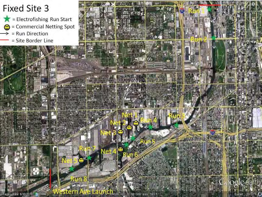
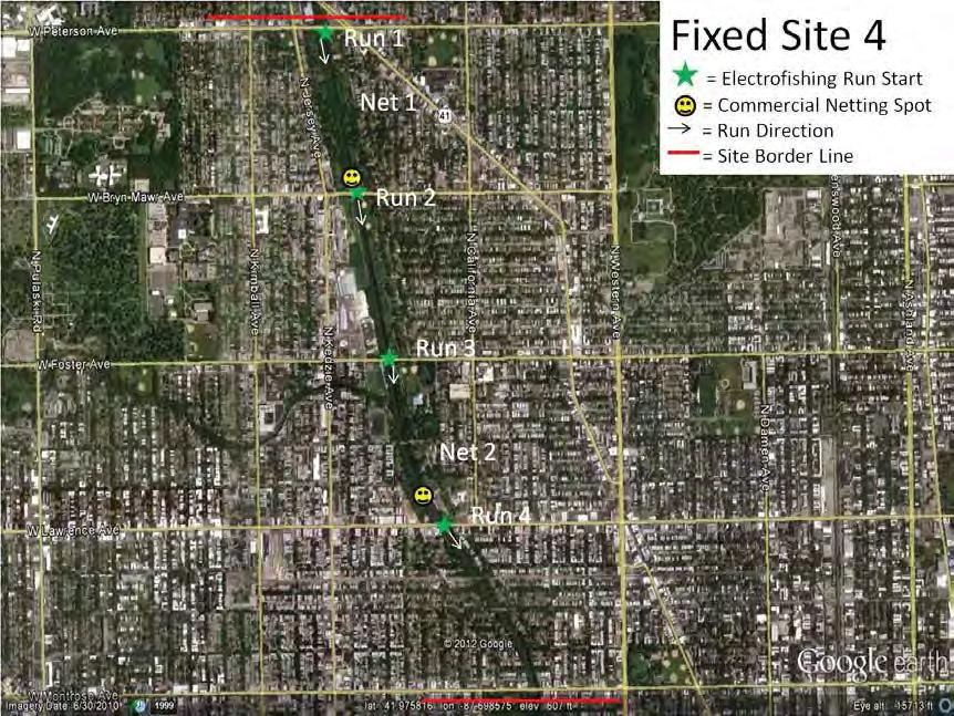
152 C-2
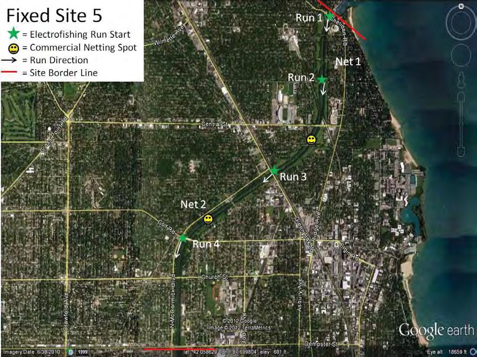
153 C-3
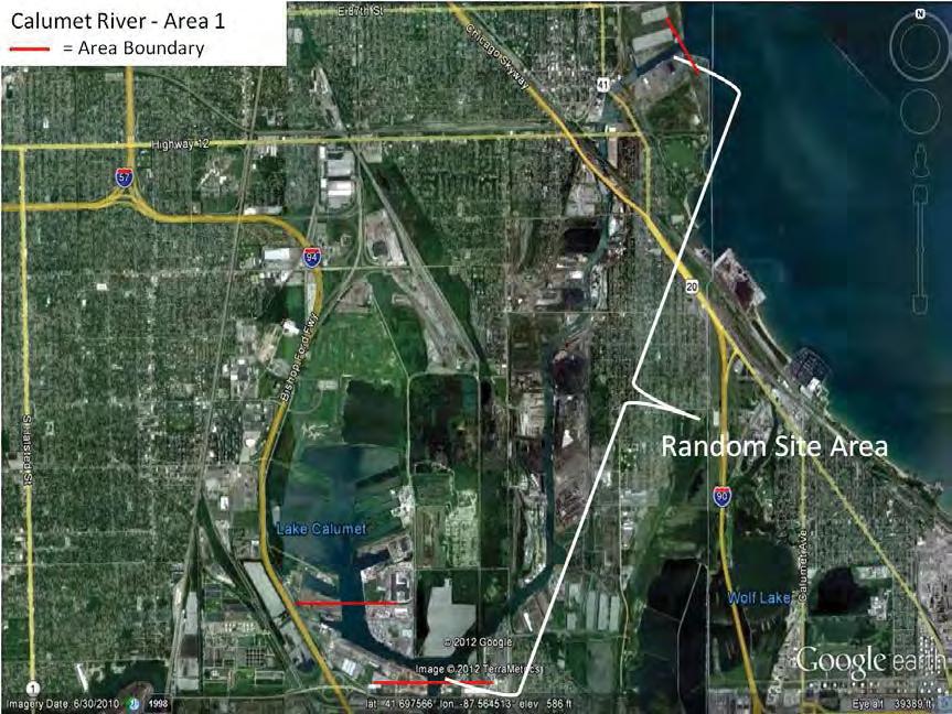

154 C-4
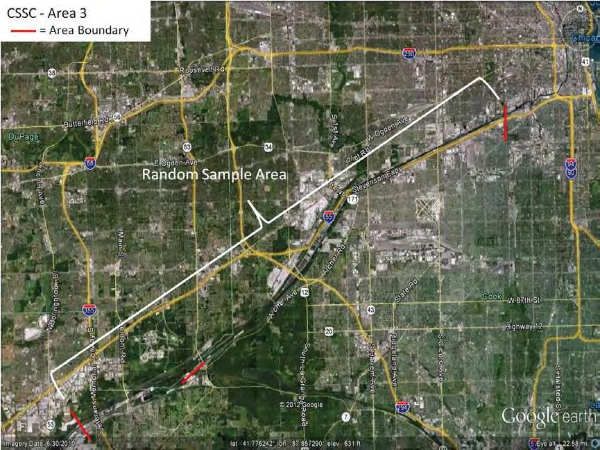
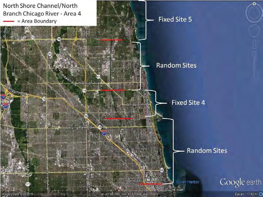
155 C-5
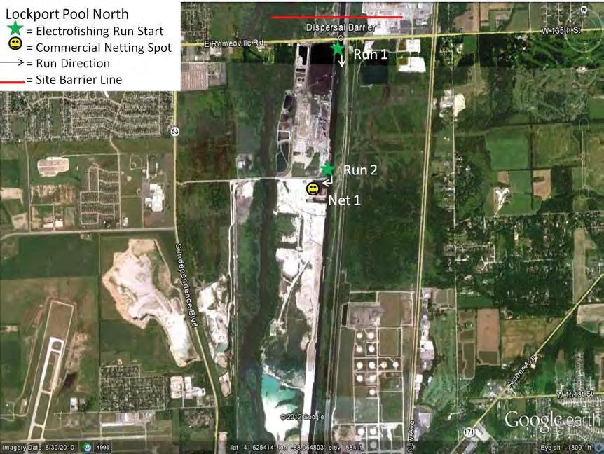
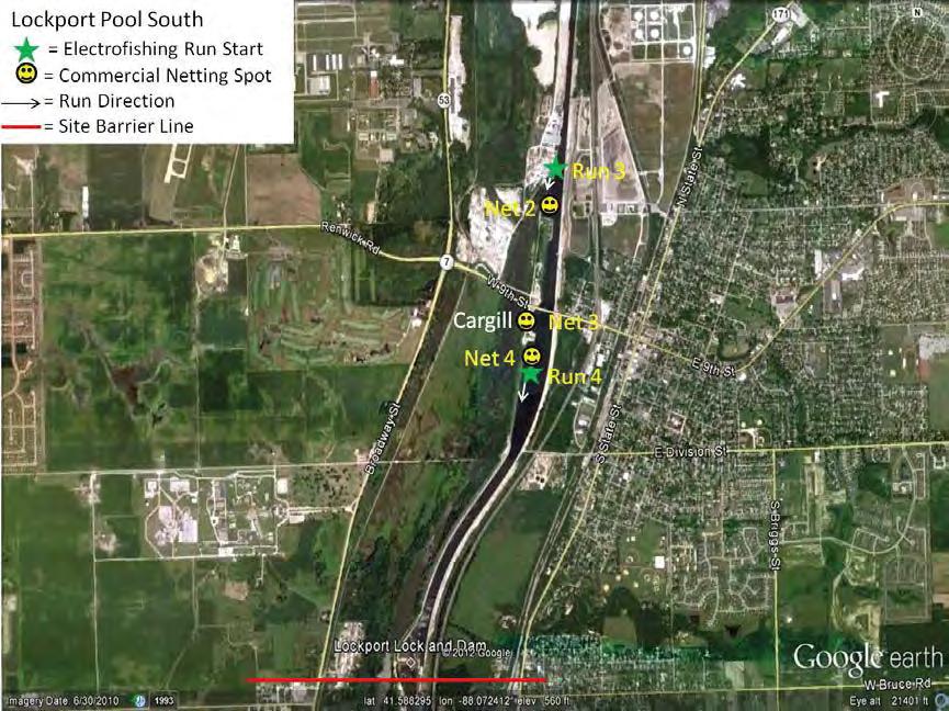
156 C-6
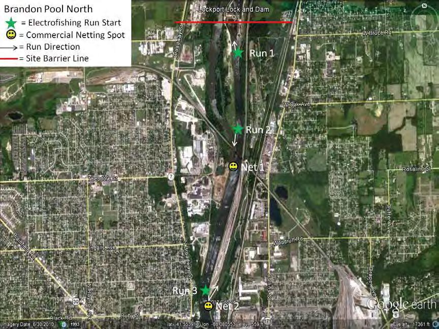
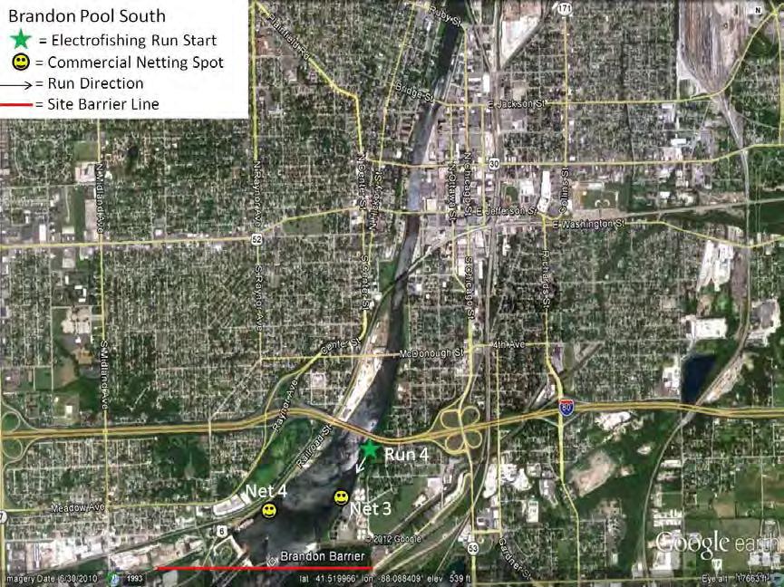
157 C-7
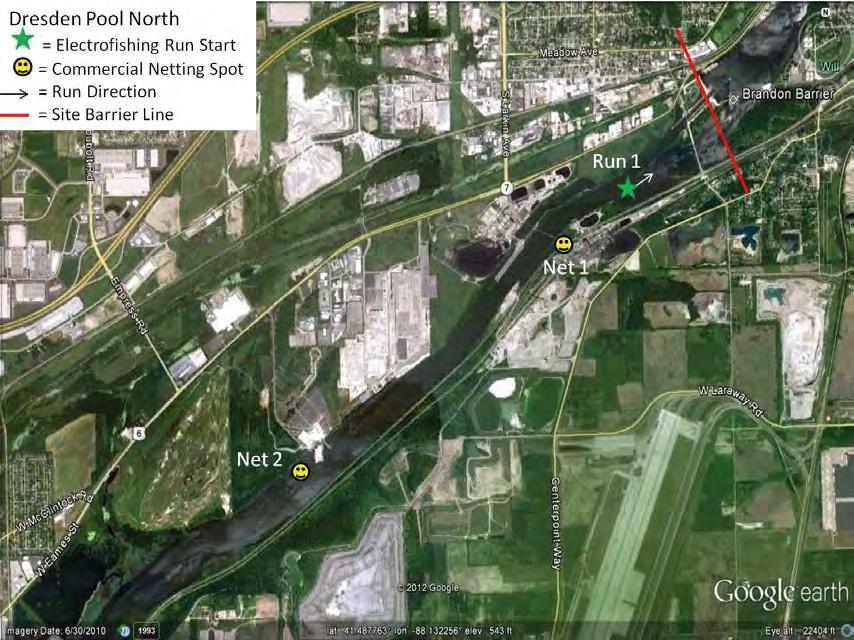
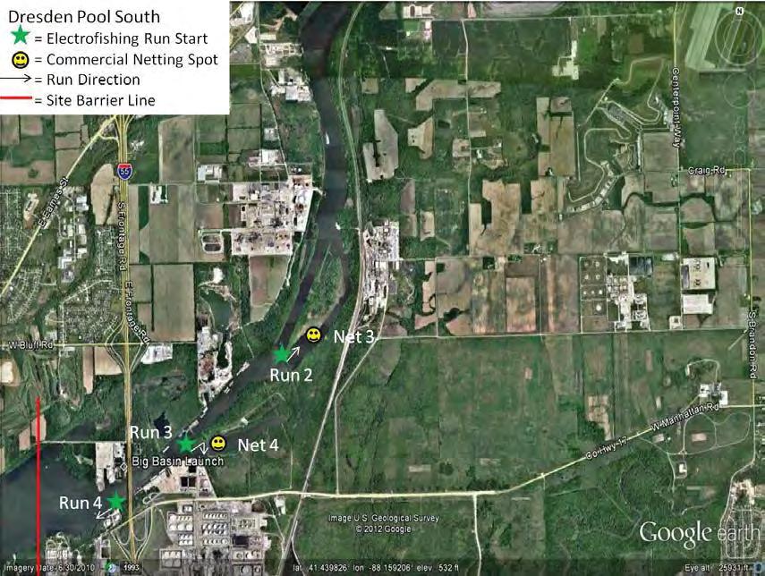
158 C-8
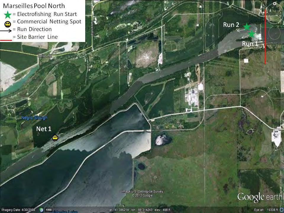
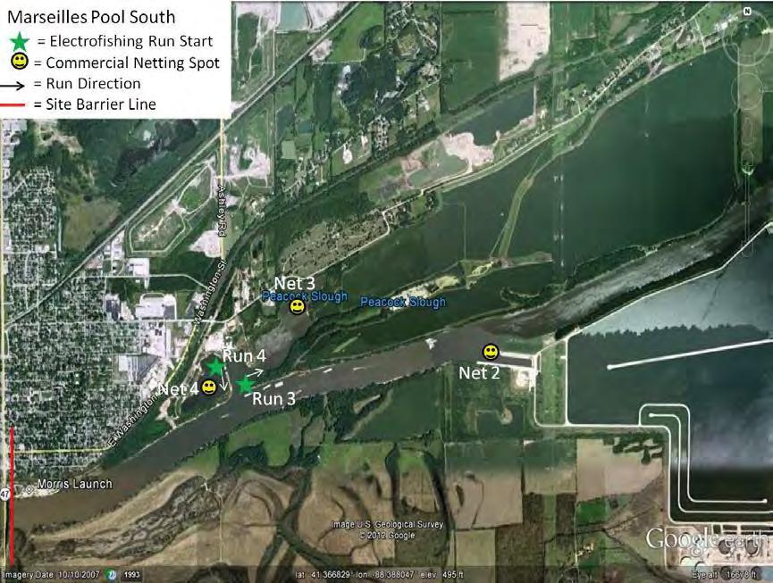
159 C-9
160 Appendix D. Handling Captured Asian Carp and Maintaining Chain-of-Custody Records Chain-of-custody is a legal term that refers to the ability to guarantee the identity and integrity of a sample from collection through reporting of the test results. The following are general guidelines to keep chain-of-custody intact throughout the fish collection process. These procedures should be followed when any Bighead or Silver carp is collected in the Chicago Area Waterway (from Lockport Lock and Dam to Lake Michigan, but also areas where they have not previously been collected (e.g. Brandon Road Pool, Des Plaines River, or Lake Michigan). 1. Keep the number of people involved in collecting and handling samples and data to a minimum. 2. Only allow authorized people associated with the project to handle samples and data. Always document the transfer of samples and data from one person to another on chain-of-custody forms. No one who has signed the chain-of-custody form shall relinquish custody without first having the chain-of-custody form signed by the next recipient. 3. Always accompany samples and data with their chain-of-custody forms. The chain-of - custody form must accompany the sample. 4. Ensure that sample identification and data collected are legible and written with permanent ink. Specific Instructions for Handling Asian Carp: 1. A. If the boat crew believes they have collected an Asian carp, they should cease further collection and take a GPS reading of the location at which the Asian carp was found or mark the location on a map provided. B. The boat crew leader should immediately notify a lead operations coordinator or chief, who will immediately notify the Incident Commander and the Conservation Police Commander, if present. If a command structure is not in place, then immediately contact an Illinois Conservation Police Officer (CPO) by contacting the IDNR Region 2 law office at x C. The boat crew will then take the fish to a staging area for identification by the fish biologist stationed at the site. If a staging area has not been designated, the boat crew should proceed to a predetermined meeting location and await the arrival of the CPO. The boat crew will not leave until the CPO arrives and they have recorded the GPS reading on a chain-of-custody form and signed the form over to the CPO. The CPO is to remain with the fish at all times. D. Once a fish biologist at the staging area makes a positive visual identification, he/she will identify the fish with a fish tag; take pictures of the tagged fish (See spawn patch D-1
161 preservation and analysis appendix for photo request, Appendix H); measure its total length (mm) and weight (g); determine the fish s gender; identify reproductive status and gonad development as immature, mature green, mature ripe, mature - running ripe, and mature spent; place the fish in a plastic bag; and seal the fish in a cooler with wet ice. The fish biologist at the staging area will place evidence tape across the opening of the cooler and initial it. The fish biologist at the staging area or when no staging area has been designated, the boat crew leader will give the sealed cooler to the IDNR CPO. The fish is to remain under IDNR control at all times. E. The CPO will then deliver the sealed fish and chain-of-custody form to the sampling laboratory on site or make arrangements for transport to the genetics laboratory at the University of Illinois (contact: Dr. John Epifanio). Soft tissue for genetic testing and hard tissue for aging and/or chemical analysis will be removed at the UIUC laboratory. Additional soft tissue samples will be collected for other cooperating genetics laboratories (e.g., ERDC), as needed. Hard tissue will be transported to SIUC for analysis (contact: Dr. Jim Garvey). Chain-of-custody will be maintained when transporting hard tissue between university laboratories. 2. Only authorized IDNR tissue samplers or persons designated by an operations coordinator or chief will unseal the fish and remove the tissue samples from the fish for preservation and delivery to the lab. The lab samples will maintain the same sample ID as the subject fish but will also include an additional sequential letter (AC 001a, AC001b, AC002a, AC002b, etc) for multiple tissue samples from one fish. While sampling is occurring, the fish and samples will remain under supervision of the IDNR CPO who will maintain the chain-of-custody form. 3. All Asian carp captured during rapid response actions should be treated with care, handled minimally (no photo ops prior to tissue sampling), and transported to the staging area where they will be stored on ice in a cooler (no plastic bags). Captured fish cannot be frozen or preserved with chemicals, as these techniques distort the DNA. The USACE Engineer Research and Development Center (ERDC) has been designated to obtain a tissue sample from any Bighead Carp or Silver Carp collected during a rapid response action. The preferred tissue for DNA analysis is a pectoral fin (the entire fin) removed with a deep cut in order to include flesh and tissue of the fin base. The fin and tissue sample will be stored in a vial containing ethanol preservative (USACE will provide vials and preservative). Samples will be transported to ERDC for sequencing and comparison to the edna found in the pool.p D-2
162 CHAIN OF CUSTODY RECORD File No. Inv. Date and Time of Collection: River Reach: Collected By: Notes: Collection No. Description of Collection (include river reach, river mileage (if known), and any serial numbers): Collection No. From: (Print Name, Agency) To: (Print Name, Agency) Release Signature: Release Date: Delivered Via: U.S. Mail In Person Other: Collection No. From: (Print Name, Agency) To: (Print Name, Agency) Release Signature: Release Date: Delivered Via: U.S. Mail In Person Other: Collection No. From: (Print Name, Agency) To: (Print Name, Agency) Release Signature: Release Date: Delivered Via: U.S. Mail In Person Other: Collection No. From: (Print Name, Agency) To: (Print Name, Agency) Release Signature: Release Date: Delivered Via: U.S. Mail In Person Other: Collection No. From: (Print Name, Agency) To: (Print Name, Agency) Release Signature: Release Date: Delivered Via: U.S. Mail In Person Other: Collection No. From: (Print Name, Agency) To: (Print Name, Agency) Release Signature: Release Date: Delivered Via: U.S. Mail In Person Other: D-3
163 Appendix E. Shipping, Handling, and Data Protocols for Wild Captured Black Carp and Grass Carp. Any suspect black carp collected in the wild in the United States and grass carp collected in the Great Lakes Basin, or other novel locations in the U.S., should be immediately reported to the appropriate resource management agency in the state where the fish was collected. Do not release suspect black or grass carp unless required by state laws or instructed to do so by the resource management agency. Differentiating black carp from grass carp using diagnostic external characteristics can be very challenging, especially when the two species are not being compared side-by-side. An identification fact sheet is attached for your reference. Careful attention should be given in waters where grass carp are known to occur to confirm that captured individuals are indeed grass carp and not black carp. If you are not positive of the species identification you should report the collection to the appropriate resource management agency to get assistance and further instructions. Collection information, basic biological data, and digital images should be collected for any suspect black or grass carp as soon as possible after capture. In addition to collection and basic biological data, we are interested in collecting multiple structures and organs from each fish for management and research purposes. Protocols are provided for 1) collection information, basic biological data, and digital images; 2) removal, preparation, and shipment of eyes for ploidy analysis; and 3) preparation and shipment of black and grass carp carcasses. These protocols are intended to provide resource management agencies, or authorized personnel, with streamlined instructions for the proper collection, preparation, and shipping of data, samples, and carcasses. It is important that all collections of black and grass carp (from the identified locations above) are immediately reported to the appropriate resource management agency in the state where the fish was collected before collecting more than collection information, basic biological data, and digital images. Step 1: Data Collection 1. Record GPS Location (if available, otherwise a description of collection location); 2. Record date and time of capture, method of capture, and collecting individual or agency; 3. Record fish weight, girth, length, and species (number samples if necessary); 4. Take high resolution digital pictures (see examples below): a. Lateral view of fish s entire left side, b. Close-up lateral view of head, c. Dorsal view of head with mouth fully closed (taken from directly above the fish s head). 5. Record name, telephone number, and/or address for point of contact; 6. data and digital images to Sam Finney at sam_finney@fws.gov. 7. Proceed to Step 2. E-1


164 Example of 4.a: Lateral view of fish's entire left Example of 4.b: Close-up lateral view of Example of 4.c: Dorsal view of head with mouth fully E-2
165 Step 2: Eyeball Removal, Sample Preparation, and Shipping Procedures for Ploidy Analysis Materials: Forceps; scalpel; blunt or curved scissors ml plastic containers with leak-proof screw top cap Sealable plastic bags to fit several ml containers Contact lens solution or saline ( % NaCl in DI water) Permanent marking pen Cooler or insulated container with ice packs, packing tape to seal cooler Optional: methanol if freezing and storing samples longer than 8 days. Procedure for Removing Carp Eyeballs: 1. Euthanize fish with an overdose of tricaine methanesulfonate (MS-222) or sharp blow to head. 2. Label small plastic container with collection date, species and sample number if applicable (e.g. 25MAR13, black carp, #12) 3. Insert scalpel blade between the eyeball and socket wall. Taking care not to puncture the eyeball, cut around the circumference of the eyeball, keeping the blade pointed toward the socket wall. You may use forceps to hold the eyeball steady. The goal is to cut the tissue responsible for holding and moving the eye. 4. Once you feel confident all the tissue around the eye is cut, use the blunt or curved scissors to reach behind the eyeball and cut the optic nerve. Once the optic nerve is cut, you should be able to pop the eye out and trim off any excess tissue. 5. Place eye in labeled container, fill to top with buffer solution, and put on ice or refrigerate at 4 to 8 C. 6. Follow Eyeball Sample Preparation and Shipping Procedures below. Sample Preparation for Overnight Shipment or Storage 1 to 8 Days: This option will provide the highest quality of samples for analysis. 1. Label a small, plastic container with collection date, species, and sample number if applicable (e.g. 25MAR13, black carp, #12) 2. Remove both eyeballs without puncturing from fish and place in labeled container. (See removal procedures above.) Fill to top with contact lens solution or saline. 3. Place container(s) in a sealable plastic bag to contain leaks and place on ice or in a cooler with ice packs. 4. Ship immediately following shipping procedures for Whitney Genetics Lab (below) or keep refrigerated (4 C - 8 C) up to 8 days. 5. Proceed to Step 3. Eyeball Sample Preparation for Storage Longer than 8 Days: If samples cannot be shipped within 8 days, or if many samples will be collected over a known period of time, you can store and ship all together. 1. Label a small, plastic container with collection date, species, and sample number if applicable (e.g. 25MAR13, black carp, #12) P E-3
166 2. Remove both eyeballs without puncturing from fish and place in labeled container. (See removal procedures above.) Fill to top with 20% methanol in contact lens solution or saline. 3. Place container(s) in a sealable plastic bag to contain leaks and place on ice or in a cooler with ice packs. Refrigerate (4 C - 8 C) overnight to allow methanol to diffuse into fish eyes. 4. Move samples to a freezer (-20 C). Store frozen until overnight shipment can be arranged. Sample quality will not degrade as long as sample remain frozen (-20 C) until shipment. 5. Ship to Whitney Genetics Lab following procedures below. 6. Proceed to Step 3. Shipping Procedures: 1. Contact Whitney Genetics Lab personnel to make Overnight Priority (for morning delivery) shipping arrangements. If possible, ship samples on same day of catch. 2. Do NOT ship samples until arrangements have been made for receipt of package. 3. Pack samples in a Ziploc bag to prevent leakage and then enclose in a sealed, insulated container with ice packs to maintain 4 to 8 C. Do NOT use dry ice for shipping. Include collection data (and sample number if necessary) with package. If using a cooler for shipping, make sure lid is taped securely. 4. Ship priority overnight to the attention of Whitney Genetics Lab Contact. 5. confirmation of shipment and tracking numbers to recipient. Contact Information: Jennifer Bailey fish biologist (mobile) jennifer_bailey@fws.gov Maren Tuttle-Lau fish biologist maren_tuttle-lau@fws.gov Shipping Address: Whitney Genetics Lab La Crosse Fish Health Center U.S. Fish and Wildlife Service Resource Center 555 Lester Ave, Onalaska, WI, Step 3: Carcass Preparation and Shipping Procedures Carcass Sample Preparation for Overnight Shipment: If possible, ship samples immediately on ice on same day of catch. Otherwise, freeze the carcass before shipping. 1. Pack entire specimen (with eyes extracted) in an insulated container with plenty of ice packs, frozen water bottles, or ice to keep cool. Do NOT use dry ice for shipping. 2. Include collection data (and sample number if necessary) in double ziplock bag in container. 3. Seal container to contain leaks. If using a styrofoam cooler within a box, make sure the lid is taped and sealed securely. 4. Ship immediately or keep frozen until Overnight Priority shipping arrangements are made. Shipping Procedures: E-4
167 1. Contact Columbia Environmental Research Center personnel to make Overnight Priority (for morning delivery) shipping arrangements. 2. Do NOT ship samples until arrangements have been made for receipt of package. 3. Ship specimen in sealed, insulated container (see sample preparation instructions above) priority overnight to the attention of Duane Chapman or Joe Deters. 4. confirmation of shipment and tracking numbers to Contact Information: Duane Chapman (mobile) Joe Deters (mobile) Shipping Address: Duane Chapman or Joe Deters Columbia Environmental Research Center U.S. Geological Survey 4200 New Haven Road Columbia, MO E-5
168 Appendix F. Fish Species Computer Codes. Species Codes Asian Carp Monitoring Alewife ALE Highfin Carpsucker HFC Spotted Sucker SDS Spring Chinook Salmon SCS Banded Darter BAD Lake Trout LAT Suckermouth Minnow SUM Banded Killifish BAK Largemouth Bass LMB Bigeye Chub BGC Logperch LOP Threadfin Shad THS Bighead Carp BHC Longear Sunfish LOS Trout Perch TRP Bigmouth Buffalo BGB Longnose Gar LOG Black Buffalo BKB Walleye WAE Black Bullhead BLB Mosquitofish MOF Warmouth WAM Black Carp BCP White Bass WHB Black Crappie BLC Northern Hog Sucker NHS White Crappie WHC Blackside Darter BLD Northern Pike NOP White Perch WHP Blackstripe Topminnow BLT White Sucker WHS Bluegill BLG Orangespotted Sunfish ORS Bluntnose Minnow BLS Oriental Weatherfish OWF Yellow Bass YLB Bowfin BOW Yellow Bullhead YEB Brook Silverside BRS Paddlefish PAH Yellow Perch YEP Brown Bullhead BRB Pumpkinseed PUD Brown Trout BRT Bullhead Minnow BUM Quillback ULL Central Mudminnow CEM Rainbow Smelt RAS Channel Catfish CCF Rainbow Trout RBT Coho Salmon CHO Redear Sunfish RSF Common Carp CAP Redfin Shiner RDS Common Shiner CMS River Carpsucker RVC Creek Chub CRC River Redhorse RVR River Shiner RVS Emerald Shiner EMS Rock Bass ROB Round Goby ROG Fall Chinook Salmon FCS Fathead Minnow FHM Sand Shiner SAS Hybrid Codes Flathead Catfish FCF Sauger SAR Bluegill x Green Sunfish BGH Freshwater Drum FRD Shorthead Redhorse SHR Bighead x Silver Carp BSH Shortnose Gar SHG Common Carp x Goldfish CGH Ghost Shiner GHS Silver Carp SCP Striped Bass x White Bass SBH Gizzard Shad GZS Silver Chub SVC Yellow Perch x White Bass YWH Golden Redhorse GOR Silver Redhorse SVR White Perch x Yellow Perch WYH Golden Shiner GOS Skipjack Herring SKH Goldeye GOL Smallmouth Bass SMB Other Codes Goldfish GOF Smallmouth Buffalo SAB Unidentified Sunfish SUN Grass Carp GRC Spotfin Shiner SFS Unidentified Minnow MIN Grass Pickerel GRP Spottail Shiner SPS Unidentified Fish UID Green Sunfish GSF Spotted Gar SPG No Fish Code NFH F-1
169 Appendix G. Sample data sheets. G-1
170 G-2
171 G-3

172 edna Field Data Sheet G-4
173 Appendix H. Understanding Surrogate Fish Movement with Barriers Floy tagging data sheet. Asian Carp Monitoring - Floy Tag Data Sheet Area Surveyed: Date: Biologist (Crew): Species Length(mm) Time Tag # Recap. Clip Loc. Latitude(Dec. Deg.) Longitude(Dec. Deg.) Gear Comments(dead/alive) H-1
.")
174 Appendix I. Analysis of Bighead and Silver Carp Spawn Patches. Spawn Patch Preservation/Analysis: Bighead and Silver Carp males use their pectoral fins to irritate the vental margin of females during the spawning season (Figure 1). Recent spawning or prespawning interactions between males and females will leave an irritated patch on the breast of the female fish, and scales are often lost. Presence of regenerated scales is evidence that a female fish may have been courted by a male fish (although it is impossible to tell from this feature if spawning actually occurred). The number of annuli in regenerated scales may also be useful in determining the number of years since spawning activity occurred. It is as yet unclear how many scales are lost on average or if scales are lost each time the fish spawns. However, in order to preserve potential information on spawning activity or presence of male fish where a female fish is captured, it is prudent to preserve the breast of Bighead and Silver Carp caught from areas where the presence of Asian carps caught is being investigated if allowable by the state and regulatory bodies. For the 2013 Monitoring and Response Plan participants, fish collected in the CAWS or the Great Lakes should follow the chain of command and custody protocols is of primary importance with biological data being collected after securing the fish. Fish collected in Brandon Road Pool require a voucher per the 2013 MRP. Additional biological data will be processed after those protocols have been followed and likely in a lab setting. For fish collected below Brandon Road Lock and Dam, it is permissible to follow the procedures as long as it would not interfere with ongoing tracking/telemetry. Figure 1. Spawn patch of a female Bighead Carp, located on the breast of the fish between the pelvic and pectoral fins. If a Bighead or Silver Carp is caught from the Great Lakes or the CAWS, FIRST FOLLOW ALL PROTOCOLS IN THIS MANUAL; See: Appendix C. Handling Captured Asian Carp and Maintaining Chain-of-Custody Records. If there is no conflict with existing protocol, the portion of the fish illustrated in Figure 2 should be photographed as soon as possible after capture, to document abrasions from recent sexual activity. In areas outside of the CAWS and the Great Lakes sections should be preserved from damage to ensure scale regeneration can be analyzed if required by state and regulatory agencies. I-1

175 Protocols for analysis of scale regeneration in this area are not yet prepared, but care should be taken to preserve the scales and skin in this area. This technique is only useful when employed on female Bighead and Silver Carp. Although external features are useful in identifying the sex of a captured Bighead or Silver Carp, none of these features are 100% reliable in identification of sex. Therefore this portion of the fish should be preserved at least until the sex is determined by the examination of the gonads. When the gonads are examined, care should be taken to avoid cutting through the area of the spawn patch. Note that histological examination of gonads may also be useful in evaluating recent spawning activity. Figure 2. Areas to be preserved for analysis. Silver Carp on left, Bighead Carp on right. (FIRST FOLLOW ALL PROTOCOLS IN THIS MANUAL See: Appendix C. Handling Captured Asian Carp and Maintaining Chain-of-Custody Records for fish collected in the CAWS or the Great Lakes; managers may not allow dissection of fish collected in these areas and need to be consulted about any physical samples being taken). I-2
176 Appendix J: Upper Illinois Waterway Contingency Response Plan Participating agencies: ILDNR, USFWS, USACE, USGS, INHS, USEPA, GLFC Introduction This Contingency Response Plan describes specific actions within the five navigation pools of the Upper Illinois Waterway (IWW) - Lockport, Brandon Road, Dresden Island, Marseilles, and Starved Rock pools (Figure 1) (river miles 231 to 327). In the event a change is detected in the status of Asian carp in those pools indicating an increase in risk level, this plan will be implemented to carry out response actions. The interagency Monitoring and Response Work Group (MRWG) has maintained a robust and comprehensive Asian carp monitoring program in the Contingency Response Plan area and will continue these efforts as the foundation for early detection capability in the IWW. Annual interim summary reports describing these efforts (including extent of monitoring and Asian carp detection probabilities) can be found at Based on this experience, MRWG is confident in its ability to detect changes to Asian carp status in the navigation pools in the upper IWW. The MRWG and ACRCC member agencies acknowledge that any actions recommended by the MRWG or ACRCC would be considered for implementation by member agencies in a manner consistent with their authorities, policies, and available resources, and subject to the decision-making processes of that particular member agency. Nothing in this plan is meant to supplement or supersede the authorities of the state or federal agencies with regard to their particular jurisdictions. For instance, no other state has authority to direct or approve actions affecting the Illinois Waterway aquatic resources other than the state of Illinois (Illinois Wildlife and Natural Resource Law [515 ILCS 5/1-150; from Ch. 56, par ]). Purpose The purpose of this Contingency Response Plan is to outline the process and procedures the MRWG and ACRCC member agencies will follow in response to the change in Asian Carp conditions in any given pool of the upper IWW. Background Existing plans for responding to the collection of Asian carps or changing barrier operations have been in place since 2011 and provided guidance focused on potential actions that could be undertaken in and around the USACE electric barrier system and in the CAWS, upstream of the Lockport Lock and Dam (River Mile, RM 291). The ACRCC relies on electric barriers within the Chicago Sanitary and Ship Canal (CSSC) at Romeoville, IL, operated by USACE, as a key tool to prevent the establishment of Asian Carp in the Great Lakes Basin. As a result, this Contingency Response Plan reduces pressure by Asian carp on the electric barriers. Previous response operations have been successfully conducted by the ACRCC in response to detections of potential Asian carp above the electric dispersal barriers, including the 2010 response in the Little Calumet River where piscicide was applied to over two miles of waterway. In addition a response was J-1
177 conducted in 2009 to protect the electric barrier system during scheduled maintenance in which five miles of the CSSC was treated with a piscicide. This enhanced Contingency Response Plan expands the geographic scope of existing contingency planning efforts, as well as the scope of potential tools to be utilized in such an event. This plan also considers barrier operations and status and is complementary and additive to the existing response plan in the MRP. Asian carp distribution has not changed significantly in either abundance or location in the upper IWW since individuals were discovered in the Dresden Island Pool in This may be due to intensive contracted fishing efforts, lack of suitable habitat upstream, water quality conditions, food availability, or a combination of other factors not yet fully understood. Despite no evidence of range expansion or increasing abundance of the Asian carp population in the upper IWW, it is generally recognized that fish populations may expand their range and abundance. Examples of introduced fishes exhibiting this phenomenon are available from other locations. Small Asian carp (less than 6 inches in length) are of special concern when considering response actions because of the risk that smaller fish may not be as effectively repelled by the electric barrier or that they may become inadvertently entrained in areas between barge tows and propelled through locks. Such entrainment has not been observed or demonstrated for either Bighead or Silver Carp. Location The IWW is a series of rivers and canals running from Lake Michigan circa Chicago, Illinois to the Mississippi River near St. Louis, Missouri. This waterway contains approximately 336 miles of canal and navigable rivers including the Chicago, Calumet, Des Plaines, and Illinois Rivers and connecting canals. The five pools of the upper IWW (upstream toward Lake Michigan) are covered by this document: Lockport, Brandon Road, Dresden Island, Marseilles, and Starved Rock (Figure 1), river miles 231 to 327. Each pool is named for the downstream Lock and Dam which impounds the waterbody. Each pool is defined as the body of water between two structures; such as a series of lock and dams. The body of water upstream of a lock and dam is given the name of that lock and dam. For instance, the Brandon Road Pool is the body of water upstream of the Brandon Road Lock and Dam. The distances (miles) from the upstream structure of a given pool to the electric dispersal barrier are as follows: Lockport- N/A, Brandon Road- 5.5, Dresden Island-10.5, Marseilles- 26, and Starved Rock J-2

178 Figure 1. Illinois Waterway Map and Profile Note: For the purposes of this map, the Lockport Pool is only highlighted up to the electric barrier system. Mission and Goal The MRWG convened a panel of experts on local Asian carp populations, waterways, and navigational structures, and charged the panel to evaluate the Asian carp population status, waterway conditions, predict future Asian carp scenarios, and develop a plan to direct appropriate, prudent, and contingency response actions as needed in the upper Illinois Waterway. Current and/or expected regulatory or other required actions are noted for each contingency measure as practical. The goal of the panel was to define contingency plans to meet the ACRCC mission as stated: The purpose of the ACRCC is to coordinate the planning and execution of efforts of its members to prevent the introduction, establishment, and spread of Bighead, Black, Grass, and Silver Carp populations in the Great Lakes. To meet this goal of the contingency plan is to provide a process to consider appropriate response actions that fully consider available tools and the authorities of member agencies to implement actions. The intent is for the plan to be clear and easy to understand while allowing flexibility needed to ensure J-3
179 response actions fully address situation-specific issues. The plan uses agreed-to terms, and is designed to be effective and transparent. This plan will also provide for open and transparent communication with the public and special stakeholder groups. This is a living document that will evolve over time as information changes and additional tools are developed e.g., ozone, hot water, microparticles, water jets, pheromones/other attractants, CO 2, or other unspecified tools). Additional Resources Considerations This contingency plan allows for deployment of aggressive monitoring or control tools deemed most appropriate by the MRWG, the ACRCC, and the governmental agency holding locational or operational jurisdictional authority. For example, one of the most aggressive responses in Asian carp prevention occurred in 2009, when approximately 6 miles of the Chicago Sanitary and Ship Canal was treated with a fish piscicide (Rotenone) in support of a barrier maintenance operation. This control action occurred at a time when Asian carp abundance and risk of a barrier breech was less understood. The Illinois DNR remains the sole legal authority to apply piscicide in its waters and has previously made decisions to do so with close consultation of many local, state, and federal partners. Illinois retains the authority, ability, and responsibility to facilitate similar actions and has already determined that this tool is not appropriate for a majority of the rivers, locations, or scopes included in this plan. While not listed as tools in this Contingency Response Plan for the MRWG to consider, the Illinois DNR reserves the right to authorize the use of piscicide in the CSSC or other developing technologies such as CO 2 or complex noise via speaker installation, when it determines the need is prudent. These technologies may be considered if convincing evidence is provided that suggests effective Asian carp control may be obtained. Temporary modification of lock operations may be used under existing USACE authorities when necessary to support other control measures within the Contingency Response Plan. The duration of the modified operation would be limited to the time necessary to carry out the supported control measures. Such modifications have supported previous barrier clearing events when electrofishing, water cannons, and/or nets were used to sample fish in and around the barrier system. In some instances, restriction of navigation traffic in the waterway may be necessary to safely execute a control measure. Such restrictions fall under the authority of the USCG. As with temporary modification of lock operations, the duration of the restriction would be limited to the time necessary to carry out the control measure. USACE and USCG have processes in place to provide timely evaluation and decisions in response to requests for temporary modified operations to support control actions by other entities and fulfill other necessary posting and communication requirements. Status This Contingency Response Plan will be operational in spring 2016, building upon and complementing existing response plans, and will be updated, as needed, based on new scientific information and available technical capacity for Asian carp control. J-4
180 Planning Assumptions These planning assumptions anticipate potential realistic situations and constraints on ACRCC and other stakeholder agencies and partners. The following assumptions pertain to all responding agencies and their resources as well as the response situation and are relevant to this planning initiative: Situation Assumptions Response actions will be selected based on the waterway conditions, and the time and geographic location of Asian Carp detection, and other factors. Response actions will be located within the designated area of the upper IWW described in the Contingency Response Plan (from Starved Rock to the Lockport Pool, as depicted in Figure 1). For planning purposes, under this Contingency Response Plan Asian Carp refers to Bighead and Silver Carp. Command, Control, and Coordination Assumptions All response operations will be conducted under the Incident Command System (ICS) or Unified Command as mandated under Presidential Policy Directive 8. Actions recommended by the ACRCC are dependent on agency authority to act. Logistics and Resources Assumptions The MRWG may request ACRCC support to leverage additional resources needed to conduct appropriate contingency response actions. Illinois as signatory to the Mutual Aid Agreement of the Conference of Great Lakes & St. Lawrence Governors and Premiers may request assistance if deemed necessary. The need for mobilization of personnel and resources from outside coordinating agencies may affect the response time and planned for accordingly. J-5
181 Concept of Operations for Response The following sections present the implementation options for the local response and coordination with the MRWG and the ACRCC stakeholders. If conditions continue to warrant respons, the number of coordinating entities could increase along with the need for additional response operations. This expansion will trigger additional command, control, and coordination elements. The overall incident complexity and Incident Command System (ICS) span of control principles should guide the incident management organization. Methods Subject matter experts from participating agencies discussed the importance of many factors within the IWW and the Asian carp populations that could potentially change and result in an increased invasion potential of the Great Lakes. The subject matter experts independently evaluated the extent of change each scenario warranted and then the group met jointly to discuss and develop a consistent opinion about the degree of change. Individuals then made independent assessments as to what level of response they would choose under the varying conditions within the decision support trees. These responses were then discussed and agreed upon by the group, which resulted in the contingency table described in section 3.5. Direct Considerations for Response The contingency table identifies whether change (moderate or significant) in management or monitoring actions is needed. It then takes into direct consideration: location of Asian carp populations (at the pool scale), life history stages (eggs/larvae, small fish (< 6 ), and large fish), and abundance (rare, common, and abundant) of Asian carp collected. Pool Navigation pool was determined to be the best and most appropriate scale for the location of Asian carp in a population (relation to distance from the electric dispersal barrier). Since pools are impoundments defined by locks and dams that have the ability to at least partially restrict movements of fish, they were chosen as the most appropriate locational references and geographic scales for contingency planning purposes. Life History Fish life history relates to the size of fish (i.e., smaller fish are less susceptible to electricity; larger fish are more susceptible to electricity; management actions may be size-specific) and also indicates the occurrence of spawning and recruitment. Abundance Increased abundance of any life stage signifies a change in the population structure at a given location and increases concern of invasion risk. Generally, larval Asian carp have not been found in the upper IWW. Finding Asian carp larvae would represent a potential change in the dynamics of the population in the upper IWW. Responses related to the detection of larval Asian carp would likely be directed at other adult or juvenile life stages of Asian carp. J-6
182 Electric Barrier Functionality The operational status of the electric barriers (barrier functionality), directly impact to the ability of Asian carp to potentially breach the barriers and move upstream of the Lockport Pool. That is, decreased barrier function increases the probability of Asian carp passage. Barrier operational status will inform actions considered when planning responses. Meetings of the MRWG and ACRCC will be convened in the event of a complete barrier outage. Such an event could also trigger a response action. Additional Considerations for Actions and Decision Making Process This process will include a recommended set of response actions for decision makers to consider when a change to the baseline condition is identified. Changes may include, but are not limited to, changes in fish population abundance, life stage presence, or new geographical positions in upstream and/or downstream pools, the ongoing rate of change in Asian carp population characteristics, season and/or water temperature, the habitat where fish are sighted or collected, flow conditions, the amount of available data, and whether multiple lines of evidence exist to support changing conditions. Additionally, the group recognized that identified response options are recommendations only. An action(s) could be more or less intense based upon the nature of the change. One example scenario is illustrated in Attachment 1. The scenario is based on a change in conditions in Brandon Road Pool as just one example of when a contingency plan is called into action, and Attachment 2 provides the decision making process and flow of likely activities in such an event. This scenario and decision process illustrates what could occur should a change be identified from this Decision Support Framework. Command, Control, and Coordination Command and control of an Asian Carp response in the IWW will be implemented under the MRWG. The Incident Command System (ICS) is a management system designed to enable effective and efficient incident management by integrating a combination of facilities, equipment, personnel, procedures, and communications operating within a common organizational structure. The MRWG will utilize the ICS to manage response operations to maximize efficiency and ensure a standard approach across all participating agencies. Area Command, Unified Command, or single Incident Commander, depending on the needs, will be maintained to determine the overarching response objectives and in implementing individual tactics necessary to accomplish each objective. Local command and control involves directing resources to establish objectives for eradication, control, or identification of Asian Carp during a response operation. Figure 2 shows the basic Unified Command organization structure that will be utilized any response that requires the mobilization of resources and multi-agency personnel as well as provides a visual representation of the basic command, control and coordination relationships for Asian Carp response personnel serving during a response. J-7
 is a standard means of documenting and communicating objectives, strategies, and tactics utilized to")
183 Figure 2. Unified Command Organization Structure Incident Action Planning An Incident Action Plan (IAP) is a standard means of documenting and communicating objectives, strategies, and tactics utilized to address issues resulting from an incident. At the core of a functional IAP are well-written objectives. The standard acronym is SMART Objective Example State agency X will contain 2 miles of the river using block nets within 8 hours of notification. jurisdiction s plans for managing an incident. SMART objectives objectives that are (1) Specific, (2) Measurable, (3) Achievable, (4) Realistic, and (5) Taskoriented. Objectives can then be inserted into an IAP template. Each response is unique, but the basic concepts of operations and objectives can be the building blocks for a solid IAP that communicates, internally and externally, the Incident action planning extends farther than just preparation and distribution of the IAP. This planning includes the routine activities during each operational period of an incident response that provide a steady tempo and routine structure to incident management. The ICS Planning P is a guide to the steps, relative chronology, and basic elements for managing an incident. By incorporating the Planning P into planning efforts, overlaying anticipated daily operational and logistical chronologies, a local jurisdiction can establish a framework for incident management that provides a rough playbook for local, state, federal, and outside resources to manage Asian Carp under catastrophic incident conditions. J-8


184 Figure 3 depicts the ICS Planning P and further describes agencies that may be involved at various steps in the process, what actions may be taken, and when actions will be implemented. Figure 3. ICS Planning "P" Notes: C&G IWW MRWG ACRCC Command and General Staff Illinois Water Way Monitoring and Response Workgroup Asian Carp Regional Coordinating Committee J-9
185 Decision Support Trees For the purposes of informing contingency response planning in the upper IWW, MRWG developed situational-based decision support trees that will aid the MRWG in determining the need for a contingency response action. These decision-support guides use common, agreed-upon definitions (see Attachment 3). The process consists of: 1) identifying the pool of interest, 2) identifying the proper life stage of Asian carp captured (verified by agency personnel) or observed during the sampling event in question, and 3) identifying whether the sampling result is Rare, Common, or Abundant relative to a baseline measurement. Figure 4 describes the entire contingency response process for all ACRCC stakeholder agencies. The decision support trees are utilized in steps 3 through 7 to assess the need for further response actions. Once all of these determinations have been made, the decision support tree (figures 5 through 10) will funnel the user to an action response level. This action response level will identify actions that could occur. Response actions may be determined by new findings in one pool, but occur in a different pool. Each pool has an agreed upon set of response actions that can be taken. If change is apparent and a response is warranted, the proper agencies will be notified and can then discuss how best to proceed based upon the options available. A chart of the potential response actions to be considered is provided in table 1. An example is also provided at the end of the decision support trees for illustrative purposes. J-10
186 Figure 4. Simplified Process Flow Chart for a Contingency Response Monitoring by ACRCC / MRWG* MRWG documentation, return to MRP or modify MRP MRWG identifies and verifies significant or moderate change MRWG formulates plan using Contingency Response Plan Describes the GENERAL PROCESS for initiating a Contingency Action** MRWG determines effectiveness of action, continues, modifies or ends actions. ACRCC briefed Communication WG as appropriate MRWG co-chairs brief ACRCC ACRCC informs members. Coordination of any requests needed for decision and action Contingency action implementation (MRWG) Unified Command as necessary * Monitoring and Response Workgroup (MRWG) is the working level body of the ACRCC. The MRWG implements the annual MRP and contingency actions subject to agency authorities and approvals by their individual Agency ** In this general process, multiple steps may happen concurrently to facilitate the most effective and efficient action is implemented. J-11
187 Figure 5. Decision Support Tree: CAWS Chicago Area Waterway 1 Eggs/Larvae Small Fish Large Fish Rare Common Abundant Rare Common Abundant Rare 2 Common Abundant Significant = Significant change from baseline requiring further response action = Moderate change from baseline requiring further response action Baseline for comparison and consideration for action is status from intense data collection up to December 31, Chicago Area Waterways includes waterways (rivers and canals between USACE electric barrier system and Lake Michigan and includes Chicago Sanitary and Ship Canal, Cal-Sag Channel, Chicago River, North Shore Channel, Little Calumet River, and Calumet River (including Lake Calumet). 2 This status is based upon the collection of a single Bighead Carp collected by Contracted Fishers in J-12
188 Figure 6. Decision Support Tree: Lockport Pool Lockport Pool to Electric Barrier System Eggs/Larvae Small Fish Large Fish Rare Common Abundant Rare Common Abundant Rare 1 Common Abundant Significant = Significant change from baseline requiring further response action = Moderate change from baseline requiring further response action Baseline for comparison and consideration for action is status from intense data collection up to December 31, This is based upon a single Bighead Carp collected in piscicide treatment of this 6 mile stretch in J-13
189 Figure 7. Decision Support Tree: Brandon Road Pool Brandon Road Pool Eggs/Larvae Small Fish Large Fish Rare Common Abundant Rare Common Abundant Rare 1 Common Abundant Significant = Significant change from baseline requiring further response action = Moderate change from baseline requiring further response action Baseline for comparison and consideration for action is status from intense data collection up to December 31, No collection of Bighead Carp or Silver Carp in this Pool; however, sightings in of 1 Bighead Carp and 1 Silver Carp have been made my MRWG efforts. J-14
190 Figure 8. Decision Support Tree: Dresden Island Pool Dresden Island Eggs/Larvae Small Fish Large Fish Rare Common Abundant Rare Common Abundant Rare Common Abundant = Significant change from baseline requiring further response action = Moderate change from baseline requiring further response action = No Change/Status Quo from baseline. No further action Baseline for comparison and consideration for action is status from intense data collection up to December 31, J-15
191 Figure 9. Decision Support Tree: Marseilles Pool Marseilles Eggs/Larvae Small Fish Large Fish Rare Common Abundant Rare Common Abundant Rare Common Abundant = Significant change from baseline requiring further response action = Moderate change from baseline requiring further response action = No Change/Status Quo from baseline. No further action Baseline for comparison and consideration for action is status from intense data collection up to December 31, J-16
192 Figure 10. Decision Support Tree: Starved Rock Pool Starved Rock Eggs/Larvae Small Fish Large Fish Rare Common Abundant Rare Common Abundant Rare Common Abundant = Moderate change from baseline requiring further response action = No Change/Status Quo from baseline. No further action Baseline for comparison and consideration for action is status from intense data collection up to December 31, J-17
193 Level of Urgency (Action Response Level) Significant Change Moderate Change Potential Actions 2 Table 1. Contingency Response Action Matrix* 1 Applicable Locations Responsible Agencies Estimated Time to Implement Regulatory or Other Requirements Relative Cost ($- $$$$) Increased Sampling Efforts 3 All IDNR/USFWS 1-7 days Sampling permits ($$) Modify Barrier Operations LP, BR USACE 1 day Coordinate with contractors ($) Complex Noise All USFWS/IDNR 1-7 days Unknown ($$) Commercial Contract Netting All IDNR 1-7 days Sampling permits/contracts ($) Hydroacoustics All USFWS/SIU/USGS 1-7 days None ($) Block Nets All IDNR 1-7 days Notice to navigation ($$) Temporary Flow Control LP, BR MWRD 1 day Notice to navigation ($) Mobile Electric Array All INHS/IDNR Months Finalize contracting, construction ($$$) Increased Sampling Efforts All IDNR 1-7 days Sampling permits ($$) Modify Barrier Operations All USACE 1 day Coordinate with contractors ($) Complex Noise All USFWS/IDNR 1-7 days Unknown ($$) Commercial Contract Netting All IDNR 1-7 days Sampling permits/contracts ($) Hydroacoustics All USFWS 1-7 days None ($) Block Nets All IDNR 1-7 days Notice to navigation ($$) No Change Maintain Current Level of Effort N/A All Ongoing N/A ($) LP Lockport, BR Brandon Road * The implementation of some of these actions may require temporary lock closures or navigation restrictions, which fall under the authority of USACE and the US Coast Guard respectively. Temporary lock closures and navigation restrictions would be limited to the time necessary to carry out the supported measures. Such lock closures have supported previous barrier clearing events when electrofishing, water cannons, and/or nets were used to sample fish in and around the barrier system. 1 Additional Resource Considerations (page J-4) describes other measures that may be brought to bare as necessary and aligned with agency authorities. 2 The current monitoring and response activities are covered under existing federal budgets. 3 Response techniques encompassed by Increased Sampling Efforts under Potential Actions in above table Technique Participating Agencies Electrofishing USFWS, ILDNR, INHS, USACE Netting (Gill, Trammel, Pound, ichthyoplankton) USFWS, ILDNR, INHS Paupier Trawling USFWS Fyke Netting ILDNR, USFWS, USACE Dozer Trawl USFWS Telemetry USACE, SIU, USGS J-18
194 Information and Data Management The ACRCC Communications Workgroup will be the primary conduit for ensuring open and transparent communication with both the public and other stakeholder agencies during an Asian Carp contingency response operation. The public and stakeholder groups will be notified as early as possible in the process and according to messaging protocols established by the ACRCC Communications Workgroups. There are many factors that may drive potential response actions including the nature of the change, severity of the change, time of year and environmental conditions. Essential Elements of Information At all points of the incident management process, Essential Elements of Information (EEI) should be collected and managed in a standard format. Paper forms, when power and electronic systems are not available and electronic data should be collected with end usage in mind. For instance, if data on how various waterways conditions are used as the basis for logistical requests and response decisions, these data should be separated and properly analyzed to ensure acquisition of adequate supplies for selected response. For response personnel, simple numerical counts of fish, numbers of each species, and all other critical data that must be communicated up the chain early and often. Additionally, routine recording and reporting of staffing levels, available resources, space, capability gaps, and projections are all important for managing overall response under a specific scenario. J-19
195 Attachment 1: Hypothetical scenario Small Asian carp are collected in Brandon Road Pool, while the barrier is operating normally. The location is first identified in the matrix, then barrier Efficacy function, next then fish life history, and finally the abundance. Based on this scenario, a significant change in actions should be considered. Brandon Road Pool Location Fish Life History Eggs/Larvae Small Fish Large Fish Rare Common Abundant Rare Common Abundant Rare 1 Common Abundant Significant Significant Change Action Implemented Abundance J-20

196 Attachment 2: Sample Action Process This example illustrates the process should three small Asian carp be collected in Brandon Road Pool. J-21
2017 Asian Carp Monitoring and Response Plan
 2017 Asian Carp Monitoring and Response Plan Table of Contents Acknowledgements ii Glossary iii Executive Summary ES 1 Introduction and Strategy 1 Current Status 3 Goals and Objectives 8 Detection Projects
Multi jurisdictional Approach to Asian carp in the Upper Illinois River and Chicago Area Waterway System. ICAIS Niagara Falls, ON.
 Multi jurisdictional Approach to Asian carp in the Upper Illinois River and Chicago Area Waterway System ICAIS Niagara Falls, ON April 22, 2013 ACRCC Organizational Structure Many more projects outlined
Crews collected 5,874 fish of 49 species and 1 hybrid group, which included 120 Banded Killifish (state threatened species).
.") June Summary Bottom Line: Monitoring occurred in the CAWS and upper Illinois Waterway downstream of the Electric Dispersal Barrier in May. NO BIGHEAD CARP OR SILVER CARP were any found in new locations
June Summary Bottom Line: Monitoring occurred in the CAWS and upper Illinois Waterway downstream of the Electric Dispersal Barrier in May. NO BIGHEAD CARP OR SILVER CARP were any found in new locations
Addressing the Threat of Asian Carp in the Great Lakes/Midwest Region
 Addressing the Threat of Asian Carp in the Great Lakes/Midwest Region Mike Weimer U.S. Fish and Wildlife Service Co-chair, Asian Carp Regional Coordinating Committee Asian Carp Regional Coordinating Committee
Management and Control of Asian Carps in the United States. Greg Conover Asian Carp Working Group, Chair USFWS, Carterville FRO
 Management and Control of Asian Carps in the United States Greg Conover Asian Carp Working Group, Chair USFWS, Carterville FRO Asian Carp 7 carps native to Asia introduced into U.S. Asian carps = bighead,
Little Calumet River Rapid Response Fish Identification and Enumeration Branch Summary Report
 Little Calumet River Rapid Response Fish Identification and Enumeration Branch Summary Report Introduction A rotenone rapid response was completed on a 2.6-mile section of the Little Calumet River immediately
Great Lakes Governance and the Risk of Grass Carp
 Great Lakes Governance and the Risk of Grass Carp Dr. John Dettmers Fishery Management Program Director Great Lakes Fishery Commission for Northeast-Midwest Institute Congressional Briefing February 6,
WELCOME Asian Carp Management and Control in the Ohio River and Upper Mississippi River Basins
 WELCOME Asian Carp Management and Control in the Ohio River and Upper Mississippi River Basins Thank you sponsors! Representative Mike Kelly (PA-3 rd ) Representative Ron Kind (WI-3 rd ) Collaborative
Appendix E: Investigate Enhanced Sampling with Traditional and New Gears to Assess Detectability for Asian Carp in the Illinois Waterway
 Steven E. Butler 1, Matthew J. Diana 1, Scott F. Collins 1, David H. Wahl 1, Clint W. Morgeson 2, Robert E. Colombo 2 1 Illinois Natural History Survey, Prairie Research Institute, University of Illinois
Tributary Use and Large Scale Movements of Grass Carps In Lake Erie
 Tributary Use and Large Scale Movements of Grass Carps In Lake Erie Travis Brenden 1, Chuck Krueger 1, Cleyo Harris 1,2, Chris Vandergoot 3 1 Department of Fisheries and Wildlife, Michigan State University
Environmental and Economic Impacts of Asian Carps in the Illinois River
 Environmental and Economic Impacts of Asian Carps in the Illinois River Photo by Nerissa Michaels Greg G. Sass Illinois River Biological Station Illinois Natural History Survey Environmental and Economic
The effects of visual and acoustic deterrents to prevent the upstream movement of Asian carps
 University of Massachusetts - Amherst ScholarWorks@UMass Amherst International Conference on Engineering and Ecohydrology for Fish Passage International Conference on Engineering and Ecohydrology for Fish
Estimated on-the-ground start and end dates: 1 June October 2018
 A. Applicant Information Name of Organization: U.S. Army Corps of Engineers, Carlyle Lake 801 Lake Road, Carlyle, IL 62231 Contact Information: Robert Wilkins, Operations Manager, (618) 594-2484, Robert.Wilkins@usace.army.mil
During the mid-to-late 1980s
 The 2001 Yellow Perch Report by Rick Kubb During the mid-to-late 1980s the yellow perch popula tions in Lake Erie were among the highest on record. Limit catches by fishermen were extremely common during
I. Project Title: Upper Yampa River northern pike management and monitoring
 COLORADO RIVER RECOVERY PROGRAM FY 217 ANNUAL PROJECT REPORT RECOVERY PROGRAM PROJECT NUMBER: 98b I. Project Title: Upper Yampa River northern pike management and monitoring II. Bureau of Reclamation Agreement
Fish Conservation and Management
 Fish Conservation and Management CONS 486 Managing biotic communities Gardening, poisoning, and shocking what would PETA think? Chapter 10 Ross Managing biotic communities Topics Organism additions Organism
ASMFC American Shad Sustainable Fishing Plan for Georgia
 ASMFC American Shad Sustainable Fishing Plan for Georgia Introduction: Submitted by Don Harrison Georgia Department of Natural Resources Wildlife Resources Division P.O. Box 289, 18 Darling Avenue Waycross,
Asian Carp and Round Goby Status
 Asian Carp and Round Goby Status Participants will learn the current status of Asian carp and Round Goby in the region and Wisconsin, and what federal and state agencies are doing to prevent their expansion.
Prepared by the. Mississippi Interstate Cooperative Resource Association. Asian Carp Advisory Committee
 Prepared by the Mississippi Interstate Cooperative Resource Association Asian Carp Advisory Committee August 2017 i Table of Contents Introduction...1 Mississippi River Basin Map...1 Upper Illinois River
West Coast Rock Lobster. Description of sector. History of the fishery: Catch history
 West Coast Rock Lobster Description of sector History of the fishery: The commercial harvesting of West Coast rock lobster commenced in the late 1800s, and peaked in the early 1950s, yielding an annual
Ohio River Basin Asian Carp Control Strategy Framework
 Ohio River Basin Asian Carp Control Strategy Framework Ohio River Fisheries Management Team October 24, 2014 Map prepared by August Fröehlich, The Nature Conservancy 1 Overview Invasive Bighead Carp and
Hydroacoustic surveys of Otsego Lake s pelagic fish community,
 Hydroacoustic surveys of Otsego Lake s pelagic fish community, 2010 1 Holly A. Waterfield 2 and Mark Cornwell 3 INTRODUCTION Hydroacoustic surveys were conducted in May and November 2010 to estimate pelagic
CHANGES IN ZOOPLANKTON COMMUNITY OF THE ILLINOIS RIVER SINCE ESTABLISHMENT OF BIGHEAD AND SILVER CARP
 CHANGES IN ZOOPLANKTON COMMUNITY OF THE ILLINOIS RIVER SINCE ESTABLISHMENT OF BIGHEAD AND SILVER CARP Collin Hinz, Mark Fritts, Greg Sass, Andy Casper Illinois River Biological Station Illinois Natural
APPENDIX 3E HYDROACOUSTIC ANALYSIS OF FISH POPULATIONS IN COPCO AND IRON GATE RESERVOIRS, CALIFORNIA NOVEMBER
 APPENDIX 3E HYDROACOUSTIC ANALYSIS OF FISH POPULATIONS IN COPCO AND IRON GATE RESERVOIRS, CALIFORNIA NOVEMBER 23 February 24 PacifiCorp Fish Resources FTR Appendix 3E.doc Hydroacoustic Analysis of Fish
Results of the 2015 nontidal Potomac River watershed Smallmouth Bass Young of Year Survey
 Results of the 2015 nontidal Potomac River watershed Smallmouth Bass Young of Year Survey Natural reproduction of smallmouth bass in the nontidal Potomac River mainstem has been assessed annually since
NOAA s Role in Chesapeake Bay
 NOAA s Role in Chesapeake Bay NOAA Chesapeake Bay Office Mission To understand, predict and explain changes in the Chesapeake Bay ecosystem, and to coordinate efforts to conserve and manage coastal and
INLAND LAKE MANAGEMENT REPORT FY Spring 2008
 INLAND LAKE MANAGEMENT REPORT FY 2008 Spring 2008 Prepared by Robert O. Andress District Fisheries Biologist E. Daniel Catchings District Fisheries Supervisor Kevin W. Baswell District Biologist Aide Department
North Carolina. Striped Mullet FMP. Update
 North Carolina Striped Mullet FMP Update Presentation for the Marine Fisheries Commission January 24, 2008 COMMERCIAL HARVEST 4,000,000 2,000,000 3,500,000 3,000,000 Landings (lb) Value ($) 1,800,000
Lake Erie Grass Carp Adaptive Response Strategy Photo source: J. Francis, Michigan Department of Natural Resources
 Lake Erie Grass Carp Adaptive Response Strategy 2019-2023 Photo source: J. Francis, Michigan Department of Natural Resources Lake Erie Committee Great Lakes Fishery Commission December 2018 Lake Erie Grass
STUDY PERFORMANCE REPORT
 STUDY PERFORMANCE REPORT State: Michigan Project No.: F-81-R-3 Study No.: 491 Title: Evaluation of lake sturgeon Acipenser fulvescens populations in the St. Clair River and Lake St. Clair Period Covered:
Monitoring and Response Plan for Asian carp in the Mississippi River Basin
 Monitoring and Response Plan for Asian carp in the Mississippi River Basin Prepared by the Mississippi Interstate Cooperative Resource Association Asian Carp Advisory Committee November 2016 Table of Contents
Susitna-Watana Hydroelectric Project (FERC No ) Salmon Escapement Study Study Plan Section 9.7
 Salmon Escapement Study Study Plan Section 9.7") (FERC No. 14241) Salmon Escapement Study Study Plan Section 9.7 Part D: Supplemental Information to June 2014 Initial Study Report Prepared for Prepared by LGL Alaska Research Associates, Inc. & Alaska
(FERC No. 14241) Salmon Escapement Study Study Plan Section 9.7 Part D: Supplemental Information to June 2014 Initial Study Report Prepared for Prepared by LGL Alaska Research Associates, Inc. & Alaska
Rhode Island Department of Environmental Management Division of Fish and Wildlife American Shad Habitat Plan for the Pawcatuck River
 Rhode Island Department of Environmental Management Division of Fish and Wildlife American Shad Habitat Plan for the Pawcatuck River Prepared by: Phil Edwards, Rhode Island Department of Environmental
NEVADA DEPARTMENT OF WILDLIFE STATEWIDE FISHERIES MANAGEMENT
 NEVADA DEPARTMENT OF WILDLIFE STATEWIDE FISHERIES MANAGEMENT FEDERAL AID JOB PROGRESS REPORTS F-2-52 216 CHIMNEY RESERVOIR WESTERN REGION NEVADA DEPARTMENT OF WILDLIFE, FISHERIES DIVISION JOB PROGRESS
Don Pedro Project Relicensing
 Don Pedro Project Relicensing M ODESTO I RRIGATION D ISTRICT TURLOCK I RRIGATION D ISTRICT FERC PROJECT N O. 2299 Resident Fish in Don Pedro Reservoir Don Pedro Reservoir Fish Stocking (1971-Present) CDFG
Cast Net Report. As required by Minnesota Statutes, section 97C.345, subdivision 3a, paragraph (c) 03/01/2018. Cast Net Report 1
 03/01/2018. Cast Net Report 1") Cast Net Report As required by Minnesota Statutes, section 97C.345, subdivision 3a, paragraph (c) 03/01/2018 Cast Net Report 1 Report to the Minnesota Legislature Minnesota Department of Natural Resources
Cast Net Report As required by Minnesota Statutes, section 97C.345, subdivision 3a, paragraph (c) 03/01/2018 Cast Net Report 1 Report to the Minnesota Legislature Minnesota Department of Natural Resources
Introduction: JadEco, LLC PO BOX 445 Shannon, IL 61078
 Introduction: was contacted to collected data on the fishery for Lake Holiday. AC Electroshocking was conducted at 2 locations on September 28, 2015. Fish population data was collected for a total of 100
Current projects for Fisheries Research Unit of Minnesota Department of Natural Resources
 Current projects for Fisheries Research Unit of Minnesota Department of Natural Resources MAJOR RESOURCE ISSUES IN THE DIVISION OF FISHERIES Status of Fish Populations To effectively manage fish populations,
An Assessment of the Fish Community in Lake Acworth
 An Assessment of the Fish Community in Lake Acworth By John Damer Fisheries Biologist Georgia Department of Natural Resources Wildlife Resources Division Fisheries Section Calhoun, GA 30701 July 2008 Introduction
ASMFC Stock Assessment Overview: Red Drum
 Introduction This document presents a summary of the 217 stock assessments for red drum. These assessments were initially conducted through the Southeast Data, Assessment and Review (SEDAR) process using
The Silver Menace: Invasive Asian Carp in the Midwest
 The Silver Menace: Invasive Asian Carp in the Midwest Timothy Spier, Michael Flinn, Neal Jackson, Jessica Morris, Allison Lebeda, and Brad Hartman Murray State University http://www.miseagrant.umich.edu/explore/native-and-invasive-species/species/fish-species-inmichigan-and-the-great-lakes/asian-carp/silver-carp-no-background/
Dauphin Lake Fishery. Status of Walleye Stocks and Conservation Measures
 Dauphin Lake Fishery Status of Walleye Stocks and Conservation Measures Date: December, 21 Dauphin Lake Fishery Status of Walleye Stocks and Conservation Measures Background: Walleye stocks in Dauphin
JadEco, LLC PO BOX 445 Shannon, IL 61078
 Introduction: With the assistance of Lake Holiday staff and volunteers, we were able to conduct an AC electrofishing survey on May 8, 27. Water temperatures were 2.3 C (8.5 F) and water clarity was decent
Susitna-Watana Hydroelectric Project Document ARLIS Uniform Cover Page
 Alaska Resources Library & Information Services Document ARLIS Uniform Cover Page Title: Wildlife harvest analysis study, Study plan Section 10.20 : Final study plan SuWa 200 Author(s) Personal: Author(s)
Implementing the New Fisheries Protection Provisions under the Fisheries Act
 Implementing the New Fisheries Protection Provisions under the Fisheries Act Discussion Paper Fisheries and Oceans Canada April 2013 Contents 1. Introduction 2. Managing Threats to Canada s Fisheries 3.
Cedar Lake Comprehensive Survey Report Steve Hogler and Steve Surendonk WDNR-Mishicot
 Cedar Lake- 2006 Comprehensive Survey Report Steve Hogler and Steve Surendonk WDNR-Mishicot ABSTRACT Cedar Lake is a 142 acre lake located in the southwest corner of Manitowoc County. It is a seepage lake
SOUTH CAROLINA ELECTRIC & GAS COMPANY COLUMBIA, SOUTH CAROLINA
 SOUTH CAROLINA ELECTRIC & GAS COMPANY COLUMBIA, SOUTH CAROLINA SALUDA HYDROELECTRIC PROJECT FERC NO. 516 DOWNSTREAM TEMPERATURE STUDY DRAFT REPORT MAY 28 Prepared by: SOUTH CAROLINA ELECTRIC & GAS COMPANY
White Perch Occurrence, Spread, and Hybridization in the Middle Illinois River, Upper Mississippi River System
 Transactions of the Illinois State Academy of Science received 2/7/02 (2002), Volume 95, #3, pp. 207-214 accepted 4/22/02 White Perch Occurrence, Spread, and Hybridization in the Middle Illinois River,
NEVADA DEPARTMENT OF WILDLIFE STATEWIDE FISHERIES MANAGEMENT
 NEVADA DEPARTMENT OF WILDLIFE STATEWIDE FISHERIES MANAGEMENT FEDERAL AID JOB PROGRESS REPORTS F-2-49 213 RYE PATCH RESERVOIR WESTERN REGION NEVADA DEPARTMENT OF WILDLIFE, FISHERIES DIVISION ANNUAL PROGRESS
Susquehanna River Walleye Fishery
 Susquehanna River Walleye Fishery 2008 The Susquehanna River is the largest tributary to the Atlantic Ocean lying completely within the United States. It originates from the outlet of Otsego Lake in Cooperstown,
Investigating reproduction and abundance of bighead carp (Hypophthalmichthys nobilis) and silver carp (H. molitrix) in the Greenup pool, Ohio River
 and silver carp (H. molitrix) in the Greenup pool, Ohio River") Investigating reproduction and abundance of bighead carp (Hypophthalmichthys nobilis) and silver carp (H. molitrix) in the Greenup pool, Ohio River Nathan Fleshman Dr. Thomas Jones Photo: USGS Photo: USGS
Investigating reproduction and abundance of bighead carp (Hypophthalmichthys nobilis) and silver carp (H. molitrix) in the Greenup pool, Ohio River Nathan Fleshman Dr. Thomas Jones Photo: USGS Photo: USGS
Goldfish control in the Vasse River: summary of the 2008 programme
 Goldfish control in the Vasse River: summary of the 8 programme Prepared by Freshwater and Threatened Fish Research Facility Prepared for February 9 1 Goldfish control in the Vasse River: summary of the
Lake Butte des Morts Commercial Seining Project Report
 Lake Butte des Morts Commercial Seining Project Report Adam Nickel, Winnebago Gamefish (excluding sturgeon) Biologist, 22 December 2014 Conducting comprehensive fish surveys on the Upriver Lakes, including
Agenda Item Summary BACKGROUND. Public Involvement ISSUE ANALYSIS. Attachment 1
 Agenda Item Summary Attachment BACKGROUND Between 996 and 03 white sturgeon fisheries in the Columbia River downstream from Bonneville Dam were managed under a series of management accords between the
ATTACHMENT F. Minnesota Department of Natural Resources. Marsh Lake Ecosystem Restoration Project
 ATTACHMENT F Minnesota Department of Natural Resources Marsh Lake Ecosystem Restoration Project Mussel Rescue and Translocation Plan for Pomme de Terre River Restoration (Prepared June, 2016) Attachment
2015 Winnebago System Walleye Report
 215 Winnebago System Walleye Report Adam Nickel, Winnebago Gamefish Biologist, March 216 As winter passes in the rear view mirror, it won t be long until the spring rush of the 216 walleye run is here.
ASMFC Stock Assessment Overview: Atlantic Menhaden
 Introduction This document presents a summary of the 217 Stock Assessment Update for Atlantic menhaden. The assessment is an update to the 215 Benchmark Stock Assessment that was peer reviewed by an independent
SKIATOOK LAKE MANAGEMENT PLAN
 SKIATOOK LAKE MANAGEMENT PLAN Background Skiatook Lake impounds Hominy Creek, 5 miles west of Skiatook in Osage County, Oklahoma (Figure 1). Skiatook Lake covers 10,540 surface acres and was constructed
NEVADA DEPARTMENT OF WILDLIFE STATEWIDE FISHERIES MANAGEMENT
 NEVADA DEPARTMENT OF WILDLIFE STATEWIDE FISHERIES MANAGEMENT FEDERAL AID JOB PROGRESS REPORTS F-20-52 2016 Lake Tahoe Rainbow Trout Study WESTERN REGION NEVADA DEPARTMENT OF WILDLIFE, FISHERIES DIVISION
Rob Tewes Senior Aquatic Biologist; ORSANCO. The Ohio River Valley Water Sanitation Commission (ORSANCO) Biological and Research Programs
 Biological and Research Programs") Rob Tewes Senior Aquatic Biologist; ORSANCO Background The Ohio River has been subject to invasions from exotic aquatic species since at least the mid to late 1800 s when Common Carp began gaining a foot-hold
Rob Tewes Senior Aquatic Biologist; ORSANCO Background The Ohio River has been subject to invasions from exotic aquatic species since at least the mid to late 1800 s when Common Carp began gaining a foot-hold
Regulations. Grabbling season May 1 July 15; only wooden structures allowed.
 Arkabutla Reservoir 219 REEL FACTS Keith Meals, Arthur Dunn, Stanley Turner Fisheries Biologists keithm@wfp.ms.gov, ArthurD@wfp.ms.gov, StanleyT@wfp.ms.gov General Information: Arkabutla Reservoir is one
Delineation of the Asian Clam (Corbicula fluminea) Population at Sand Harbor State Park, Nevada
 Population at Sand Harbor State Park, Nevada") Delineation of the Asian Clam (Corbicula fluminea) Population at Sand Harbor State Park, Nevada Report to the Nevada Division of State Lands and the Tahoe Regional Planning Agency Final Draft Brant Allen,
Delineation of the Asian Clam (Corbicula fluminea) Population at Sand Harbor State Park, Nevada Report to the Nevada Division of State Lands and the Tahoe Regional Planning Agency Final Draft Brant Allen,
ADDENDUM I TO AMENDMENT 3 OF THE INTERSTATE FISHERY MANAGEMENT PLAN FOR WEAKFISH
 ATLANTIC STATES MARINE FISHERIES COMMISSION ADDENDUM I TO AMENDMENT 3 OF THE INTERSTATE FISHERY MANAGEMENT PLAN FOR WEAKFISH Prepared by the Weakfish Plan Review Team Approved October 18, 2000 TABLE OF
Little Kern Golden Trout Status:
 Little Kern Golden Trout Status: The Little Kern Golden trout (LKGT) was proposed for federal listing as Threatened under the Endangered Species Act (ESA) on September 1, 1977 by the U. S. Fish and Wildlife
Application of a New Method for Monitoring Lake Trout Abundance in Yukon: Summer Profundal Index Netting (SPIN)
") Application of a New Method for Monitoring Lake Trout Abundance in Yukon: Summer Profundal Index Netting (SPIN) Prepared by: Lars Jessup Nathan Millar November 2011 Application of a New Method for Monitoring
Application of a New Method for Monitoring Lake Trout Abundance in Yukon: Summer Profundal Index Netting (SPIN) Prepared by: Lars Jessup Nathan Millar November 2011 Application of a New Method for Monitoring
FY 2012 ANNUAL PROJECT REPORT PROJECT NUMBER: 123-b. I. Project Title: Nonnative fish control in the middle Green River
 COLORADO RIVER RECOVERY PROGRAM RECOVERY PROGRAM FY 2012 ANNUAL PROJECT REPORT PROJECT NUMBER: 123-b I. Project Title: Nonnative fish control in the middle Green River II. Bureau of Reclamation Agreement
Status of Yellow Perch in Lake Michigan
 Status of Yellow Perch in Lake Michigan 2016 2017 [Wisconsin DNR biologist Pradeep Hirethota with a nice Lake Michigan perch. This report is published in memory of Pradeep who passed away in December 2017.
Name of Applicant Phone Number # Mailing Address. City State Zip
 VIRGINIA DEPARTMENT OF GAME AND INLAND FISHERIES EXOTIC SPECIES APPLICATION/PERMIT TO IMPORT CERTIFIED TRIPLOID GRASS CARP FOR AQUATIC VEGETATION CONTROL IN PRIVATE PONDS (Under Authority of 4 VAC 15-30-40
Peace River Water Use Plan. Monitoring Program Terms of Reference. GMSMON-1 Peace River Creel Survey
 Peace River Water Use Plan Monitoring Program Terms of Reference GMSMON-1 Peace River Creel Survey April 10, 2008 Terms of Reference for the Peace River Water Use Plan Monitoring Program: Peace River Creel
Managing Development and Chesapeake Bay s Estuarine Fish
 Managing Development and Chesapeake Bay s Estuarine Fish Habitat Image and or Graphic Fisheries James H. Uphoff Jr. and Margaret M. McGinty Maryland Fisheries Service Funded through USFWS Federal Aid Maryland
Potomac River Fisheries Commission s. American Shad Fishing / Recovery Plan. Submitted to the Atlantic States Marine Fisheries Commission
 Potomac River Fisheries Commission s American Shad Fishing / Recovery Plan Submitted to the Atlantic States Marine Fisheries Commission January 10, 2012 1. Sustainable Fishery Plan In accordance with the
Declaration of Panama City
 CFMC/OSPESCA/WECAFC/CRFM 1 Working Group on Queen Conch (QCWG) Panama City, Panama, 23 25 October 2012 Declaration of Panama City The Members of the CFMC/OSPESCA/WECAFC/CRFM Working Group on Queen Conch:
WFC 10 Wildlife Ecology & Conservation Nov. 29, Restoration Ecology: Rivers & Streams. Lisa Thompson. UC Cooperative Extension
 Restoration Ecology: Rivers and Streams WFC 10 29 Nov 2010 Restoration of ecosystems often involves creating new systems with only partial resemblance to the original ecosystems Lisa Thompson Fisheries
Columbia Lake Dam Removal Project
 Columbia Lake Dam Removal Project Major Goals of the Columbia Lake Dam Removal: Reconnect 10 miles of the Paulins Kill River to the Delaware River, restoring natural flow regime and sediment transport.
Report on a Salmon Survey in the Waterford Estuary in 2010
 Report on a Salmon Survey in the Waterford Estuary in 2010 Dr. P. Gargan Inland Fisheries Ireland June 2011 1 Contents 1. Introduction 3 2. Proposal for a Survey in Waterford estuary in 2010 3 3. Survey
Behavior and survival of hatchery reared advanced fingerling largemouth bass using radio telemetry. Brandon Thompson
 Behavior and survival of hatchery reared advanced fingerling largemouth bass using radio telemetry Brandon Thompson Florida largemouth bass Micropterus salmoides floridanus Premier freshwater sportfish
IFS Carp Management Program 2014
 Carp Captures at a Glance Lake Sorell January March 2014 (Total) Adult/Juvenile Total 1995 to present 1761 0-1761 39,303 Lake Crescent January March 2014 (Total) Adult/Juvenile Total 1995 to present 0
Admiralty Inlet Pilot Tidal Project FERC No Appendix C. Derelict Gear Monitoring Plan
 Appendix C Derelict Gear Monitoring Plan ADMIRALTY INLET PILOT TIDAL PROJECT FERC PROJECT NO. 12690 DERELICT GEAR MONITORING PLAN (submitted with the Final Application for a New Pilot Project License)
BURBOT IN THE KOOTENAI RIVER, IDAHO: A STORY OF SUCCESS
 BURBOT IN THE KOOTENAI RIVER, IDAHO: A STORY OF SUCCESS T.J. Ross, Ryan Hardy, and Andy Dux, Idaho Department of Fish and Game Shawn Young, Nate Jensen, and Sue Ireland, Kootenai Tribe of Idaho OVERVIEW
The Joint Strategic Plan and its Role in Management of Invasive Fishes
 The Joint Strategic Plan and its Role in Management of Invasive Fishes John Dettmers, Great Lakes Fishery Commission November 7, 2018 Ann Arbor, Michigan 2 Un-successful attempts at cooperation Failed
Report to the Joint Standing Committee on Inland Fisheries and Wildlife
 Report to the Joint Standing Committee on Inland Fisheries and Wildlife As Required by 12 Section 10107-A White-tailed Deer Population Management Written By: Wildlife Management Staff, Inland Fisheries
Mass Marking and Management of Great Lakes Fisheries
 Mass Marking and Management of Great Lakes Fisheries T. Newcomb and K. Smith Michigan Department of Natural Resources M. Staggs Wisconsin Department of Natural Resources D. Stang New York Department of
Columbia Lake Dam Removal Project
 Columbia Lake Dam Removal Project The Columbia Lake dam located 1/4 mile upstream of the Paulins Kill River's confluence with the Delaware River in Knowlton Township, Warren County has been proposed for
NEVADA DEPARTMENT OF WILDLIFE STATEWIDE FISHERIES MANAGEMENT
 NEVADA DEPARTMENT OF WILDLIFE STATEWIDE FISHERIES MANAGEMENT FEDERAL AID JOB PROGRESS REPORTS F-20-48 2012 RYE PATCH RESERVOIR WESTERN REGION NEVADA DEPARTMENT OF WILDLIFE, FISHERIES DIVISION JOB PROGRESS
SEA GRANT PROGRESS REPORT
 SEA GRANT PROGRESS REPORT Project Title: The relationship between seasonal migrations of berried female lobster Homarus americanus, egg development and larval survival. Principal Investigator: Winsor H.
THE CONFEDERATED TRIBES OF THE WARM SPRINGS RESERVATION OF OREGON
 THE CONFEDERATED TRIBES OF THE WARM SPRINGS RESERVATION OF OREGON To: Branch of Natural Resources P.0. Box C, Warm Springs, Oregon 97761 Phone (541) 553-2002/2003 Fax (541) 553-1994 The Independent Science
FINAL Caples Lake Fisheries Management Plan. Version 4.0
 FINAL Caples Lake Fisheries Management Plan Version 4.0 August 15, 2008 Purpose The Caples Lake Fisheries Management Plan (Plan) outlines the stocking plan to reestablish a sport fishery in Caples Lake
Applying Engineering Solutions to the Science of Invasive Aquatic Species Control Asian Carp and Sea Lamprey. Bill Holman, P.E. Stanley Consultants
 Applying Engineering Solutions to the Science of Invasive Aquatic Species Control Asian Carp and Sea Lamprey Bill Holman, P.E. Stanley Consultants Sea Lamprey: Great Lakes Invader Lake Superior Sea Lamprey
2014 Winnebago System Walleye Report
 1986 1988 199 1992 1994 1996 1998 2 22 24 26 28 21 212 214 Number of YOY WAE / Trawl 214 Winnebago System Walleye Report Adam Nickel, Winnebago Gamefish Biologist, 18 March 215 The spring rush of 215 will
FY 2015 ANNUAL PROJECT REPORT PROJECT NUMBER: 163
 COLORADO RIVER RECOVERY PROGRAM RECOVERY PROGRAM FY 2015 ANNUAL PROJECT REPORT PROJECT NUMBER: 163 I. Project Title: Monitoring multi-life stages of the fish community in the lower Gunnison and upper Colorado
Amendment to a Biological Assessment/Evaluation completed for the Coon Creek Land Disposal completed December Grand Valley Ranger District
 Amendment to a Biological Assessment/Evaluation completed for the Coon Creek Land Disposal completed December 2007 Grand Valley Ranger District Grand Mesa, Uncompahgre, Gunnison National Forests Prepared
Regulations. Grabbling season May 1 July 15; only wooden structures allowed.
 Enid Reservoir 218 REEL FACTS Keith Meals, Arthur Dunn, Stanley Turner Fisheries Biologists keithm@mdwfp.state.ms.us, ArthurD@mdwfp.state.ms.us, StanleyT@mdwfp.state.ms.us General Information: Enid Reservoir
COLUMBIA LAKE DAM REMOVAL PROJECT
 COLUMBIA LAKE DAM REMOVAL PROJECT Major Goals of the Columbia Lake Dam Removal: Reconnect 10 miles of the Paulins Kill River to the Delaware River, restoring natural flow regime and sediment transport.
NEVADA DEPARTMENT OF WILDLIFE STATEWIDE FISHERIES MANAGEMENT
 NEVADA DEPARTMENT OF WILDLIFE STATEWIDE FISHERIES MANAGEMENT FEDERAL AID JOB PROGRESS REPORTS F-20-52 2016 RYE PATCH RESERVOIR WESTERN REGION NEVADA DEPARTMENT OF WILDLIFE, FISHERIES DIVISION ANNUAL PROGRESS
Near-Field Sturgeon Monitoring for the New NY Bridge at Tappan Zee. Quarterly Report July 1 September 30, 2014
 Near-Field Sturgeon Monitoring for the New NY Bridge at Tappan Zee Quarterly Report July 1 September 30, 2014 Prepared by AKRF, Inc. 7250 Parkway Drive, Suite 210 Hanover, MD 21076 for New York State Thruway
Hydroacoustic survey of Otsego Lake, 2004
 Hydroacoustic survey of Otsego Lake, 2004 Thomas E. Brooking 1 Mark D. Cornwell 2 INTRODUCTION Fishery managers must often rely on uncertain information regarding abundance and distribution of offshore
las vegas wash coordination committee
 las vegas wash coordination committee lvwash.org Proposal to Conduct a Small Mammal Study in the Las Vegas Wash, Nevada March 2009 Proposal to Conduct a Small Mammal Study in the Las Vegas Wash, Nevada
Fisheries Management Zone 10:
 Fisheries Management Zone 10: Lake Trout Operational Objectives and Management Photo Credit: www.jamessmedleyoutdoors.com 2 FMZ 10: Lake Trout Operational Objectives and Management Lake trout are the second
Chagrin River TMDL Appendices. Appendix F
 Appendix F The following are excerpts from the Eastern Brook Trout Joint Venture s Conservation Strategy (Working Draft v.6), Conserving the Eastern Brook Trout: Strategies for Action Found at: http://www.easternbrooktrout.org/constrategy.html
NEED FOR SUPPLEMENTAL BATHYMETRIC SURVEY DATA COLLECTION
 305 West Grand Avenue, Suite 300 Montvale, New Jersey 07645 Phone 201.930.9890 Fax 201.930.9805 www.anchorqea.com M EMORANDUM To: Caroline Kwan and Nica Klaber U.S. Environmental Protection Agency Region