Habitat assessment of the area of the Cardigan Bay SAC proposed for a fishing intensity experiment
|
|
|
- Jesse Fields
- 6 years ago
- Views:
Transcription


1 Bangor University Fisheries and Conservation Report No. 23 Habitat assessment of the area of the Cardigan Bay SAC proposed for a fishing intensity experiment Gwladys Lambert, Lee Murray, James D. Bennell & Michel J. Kaiser School of Ocean Sciences, College of Natural Sciences, Bangor University To be cited as follows: Lambert, G. I., Murray, L.G., Benell J.D. & Kaiser, M.J. (2013). Habitat assessment of the area of the Cardigan Bay SAC proposed for a fishing intensity experiment. Fisheries & Conservation report No. 23, Bangor University. Pp.51
2 Contents Introduction Description of the area proposed for the experiment Existing seabed maps Video and still images surveys Side scan surveys Additional information Experimental design Discussion References
3 Introduction The Fisheries and Conservation Science Group of Bangor University is proposing to run an experiment in the Cardigan Bay SAC, as part of their EFF project. The work aims at determining thresholds of scallop fishing impact on the seabed in order to advise the Welsh Government on possible sustainable options for the scallop fishery in an ecosystem approach framework. The proposed location of the experiment is on a previously exploited scallop bed that has been closed to fishing activities for 5 years. Cardigan Bay was originally selected as an SAC primarily to protect the resident bottlenose dolphin population (Tursiops truncates). Seabed habitats, i.e. stony reefs, were not the primary focus of the designation but were included as quality features of the designated site. Therefore, following previous advice from CCW to the Welsh Government, the area proposed for the fishing experiment lies between 3 and 12nm, avoiding any potential adverse effects between dolphin prey/dolphin habitat and scallop gear interactions within 3nm. Furthermore, in order to conduct the fishing experiment proposed within the EFF project, an appropriate assessment has to be conducted to provide evidence of the absence of stony reefs in the area of the SAC that would be impacted by fishing gears during the experiment. In 2008, JNCC held a workshop with experts of the UK s Statutory Nature Conservation Bodies (SNCBs) to define the term stony reef in practical terms to aid in the classification of these habitats. The stated aim was to clarify the definition of stony reef under the Habitats Directive and to help with recognizing those areas of the seabed that can be classed as stony reef, and those areas that would fall outside this definition (Irving 2009). The results of this workshop were summarized in a report in 2009 (Irving 2009) and represent the most recent unified view of the SNCBs. Several abiotic and biotic parameters were evaluated as descriptors that could be used for the classification of stony reefs and four of these were felt most practical in deciding if a habitat comprised a stony reef or not. These were: composition (referring to the sediment type), elevation, extent and biota (see Table 1). Each characteristic was given a four point grading from not representing a reef to high reefiness (see Table 1). It should be noted that the most important overarching criteria is the composition of the sediment, in other words the percentage of stones present at a site to qualify as a stony reef (10% of stones have to be larger than 64 mm for a habitat to be considered as reef like, see Table 1). This is therefore the main focus of the present report, which gathers extensive available evidence on the seabed composition of the potential experimental area. Extent and elevation were also looked at to the extent possible and wherever relevant. However, biota was judged to be a qualitative indicator of conservation value by the JNCC report but no clear criteria with respect to biota was set other than the dominance of epibenthic species as opposed to infaunal species (Table 1). As the past surveys did not assess infaunal benthic communities in the area of interest, this aspect of the reefiness criteria was not explored, 2

4 although some information on epifauna is presented. Details of the proposed experiment are described at the end of the report. Table 1. Summary of the main characterising features of a stony reef as outlined by the JNCC report (Irving 2009). 3

5 1 - Description of the area proposed for the experiment The area proposed for the experiment is approximately 110km 2 (ca. one ninth of the total Cardigan Bay SAC area, which is ca. 960km 2 ). Part of it will be impacted by fishing gear while the rest will be used as control areas, i.e. non-impacted areas to which impacted areas could be compared to monitor direct impact as well as long term recovery. The details of the proposed experiment are explained in the last section of the present report (section 6). Figure 1 shows the proposed area where the experiment would take place. Figure 2. Proposed experimental area and location of video tows which have been conducted with the Prince Madog (PM) by the School of Ocean Sciences, Bangor University, and individual fishermen between 2009 and 2012, in the Cardigan Bay SAC. 4
6 2 - Existing seabed maps In an effort to gather all the existing evidence, seabed maps of various sources were collected. Figures 2, 3 and 4 present maps of the Cardigan Bay SAC, with focus on the experimental area. Of those 3 maps of various sources, none of them suggest the likely existence of reefs in the proposed experimental area. Figure 2. Subtidal reefs and sandbanks of the Cardigan Bay SAC (contains Natural Resources Wales information Natural Resources Wales and database right). 5

7 Figure 3. Map of sediment types in the suggested experimental area (source Edina Digimap) 6

8 Figure 4. ROXAN map of the proposed experimental area (source unknown) 7
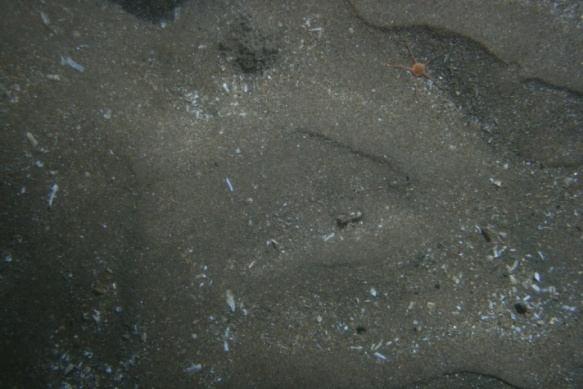
9 3 - Video and still images surveys Numerous video and stills surveys conducted by Bangor University have taken place in the Cardigan Bay SAC since 2009 during 3 consecutive years: December 2009, June 2010, October 2010 and April Additionally, 2 surveys have been conducted as part of the EFF project of Bangor University in June 2012 and October Most of the sites surveyed were the same year after year, in an effort to monitor habitat recovery in the protected area compared to the area remaining open to fishing. However, fishermen started collecting their own data and Len Walters, fisherman from Cardigan Bay, conducted a detailed survey of the proposed experimental area in October 2012, targeting sites which had not previously been surveyed by Bangor University and the EFF project team. All the sites surveyed are mapped in Figure 5, for a total of 68 data points. The surveys conducted by Bangor University and the EFF team were conducted onboard the RV Prince Madog. A sledge mounted video and stills camera system was deployed at each sampling station and towed at a speed of approximately 0.5 knots for a period of 10 to 15 minutes. Start and end positions of each tow were recorded from the point the sledge had visibly reached the sea floor to the point when the sledge lifted off the ground during hauling. While the video system delivered a continuous live picture which was recorded on DVD, the digital stills camera took a high resolution image every 9 or 10 seconds. Each still image covered an area of 0.13m 2 (0.44m x 0.30m). A different system was used to film the seabed from the fishing vessel. A minisled was designed to be towed from a small scalloping or potting vessel. A GoPro video camera was fitted at an angle of approximately 30 degrees to the seabed and the sled was towed for about 15-20minutes at low speed (<1kn). The video frame covered an area of approximately 0.5m 2. Pictures from the sites surveyed by Bangor University and the EFF team and videos from the sites surveyed by the fishers (tows shown in Figure 1) were analysed for substratum type (Figure 5). Since the videos and pictures had initially been collected and analysed by different scientists and for different objectives, they were all reanalysed using a consistent methodology for the purpose of the present report, using the software CPCe. This software was initially developed for coral reef analyses. It allows the distribution of random points on an image and the categorisation of the sediment by attributing a category to each point. It then reports the sediment type percentages in an Excel format. On average between 10 and 30 pictures or video frames were analysed at each site, depending on the apparent heterogeneity of the substratum along the tow. The classification used followed the Wentworth scale (Table 2). Since the videos could not allow the distinction between anything smaller than 2mm, only 5 categories were used (fine particles (<2mm), gravel (2-4mm), pebble (6-64mm), cobble (64-253mm), and boulders/bedrock (>253mm). The objective of the research being to find out whether cobble reefs existed in the area, this classification was deemed appropriate. 8
10 Table 2. Udden-Wentworth Grain-Size Classification Scheme (Wentworth, 1922) Figure 5 shows the sediment composition at each of the sampled sites. Overall, the proposed experimental area appears mostly shelly in the north with a trend towards increased percentages of pebbles and gravel in the south west corner. This reflects well the Roxan map presented Figure 4. Mixed substratum types are found in the south east area with presence of brittlestar beds. Some cobbles and boulders seem to be present in greater proportions in the centre and towards the north of the area. The presence of potential reefs, according to the JNCC definition is shown in Figure 6. It shows that there is no evidence of the presence of reefs at most sampled sites in the proposed experimental area. Only 2 sites showed potential low reefiness (respectively 14% and 28% of cobbles/boulders/bedrock). 9
, Boulder (BO), Cobble (CO), Pebble (PB), Gravel (GV), Fine sediment (FS), Shells (SH), Brittle stars (BS), Other organism")
11 Figure 5. Sediment composition of all sites sampled between 2009 and 2012 in the proposed experimental area as mapped in Figure 1. Bedrock (BDR), Boulder (BO), Cobble (CO), Pebble (PB), Gravel (GV), Fine sediment (FS), Shells (SH), Brittle stars (BS), Other organism (ORG). 10
 classified according to stony reef criteria outlined")
12 Figure 6. Percentage of cobble and boulder coverage (including bedrock) classified according to stony reef criteria outlined by JNCC for all sites sampled between 2009 and 2012 in the proposed experimental area as mapped Figure 1. 11
13 4 - Side scan surveys Based on the above data on sediment composition from video surveys and previous knowledge, NRW advised on which areas should be targeted for further investigation by side scan (Figure 7). A B E D C Figure 7. Areas where side scan surveys were advised by NRW, overlaid on cobble and boulder coverage (see Figure 6 legend). The red boxes were to be covered by a grid of side scan lines, the blue boxes were for 100% cover if possible with minimum 100% coverage of the green boxes in case the coverage of the blue areas was not logistically feasible. Figure 8 shows the coverage that was achieved during the survey conducted by the Welsh Government in May

14 Figure 8. Side scan survey conducted by the Welsh Government in May 2013, with NRW recommended side scan overlaid (see Figure 7 legend). As it was not logistically possible to cover every box identified by NRW during the short period of time available for the side scan survey, the northern red area was not surveyed and the blue boxes were not covered at 100%. However, the green boxes (the minimum requirement) were covered at 100% and two out of three red boxes were covered with a grid, following NRW advice. Additionally, 3 side scan lines, running from north to south of the suggested experimental area, had been completed by the School of Ocean Sciences, Bangor University, during a survey in June Those lines partly cover the northern red box in which NRW had advised to conduct a gridded side scan survey in May The lines also add information in the blue boxes and the 2 southern red boxes (Figure 9). 13
15 Figure 9. Side scan survey conducted by the School of Ocean Sciences, Bangor University, in June 2010, with NRW recommended side scan overlaid (see legend figure 7). The first side scan survey (Figure 8) was conducted over a 2 day period from 1st to 2nd May 2013 using the Welsh Government Fisheries Patrol and Science vessel MV Cranogwen. The side scan sonar system was an EdgeTech 4125 series dual frequency side scan sonar system using a 200m tow cable on a winch powered by the boats generator. A sonar range of 100m (total swath width 200m) was employed throughout, with the tow-fish altitude above the seabed kept between 5 to 10m. The second side scan survey (Figure 9) was conducted over a 3 day period from 22 nd to 24 th June 2010 using the fishing vessel MFV Mercurius. The side scan sonar system was a Cmax CM2 system using a 300m tow cable on a 24v battery powered winch. A sonar range of 100m (total swath width 200m and sonar frequency 325kHz) was employed throughout, with the tow-fish altitude above the seabed kept between 5 to 10m. All survey lines were run perpendicular to 14

 were covered perpendicularly and horizontally to the coast.")

16 the coast as these were found to give the clearest images with the more distinct shadows in the December 2009 survey (Hinz et al 2010b). Analysis of side scans Side scans were visually analysed and maps were created in an effort to highlight the visible differences in texture. It has to be noted however that the interpretation was made difficult by the occurrence of horizontal lines in the images, likely due to the speed at which the vessel steamed during the survey. Furthermore, two of the areas which were covered at 100%, areas A and B (Figures 7 and 8) were covered perpendicularly and horizontally to the coast. As already noted during the December 2009 survey (Hinz et al. 2010a), the lines that were perpendicular to the coast gave the most distinct shadows, i.e. were better to identify features. Only perpendicular lines were therefore analysed. The lines in area C were not perpendicular to the coast, therefore the best direction, i.e. the direction that showed most distinguishable shadows, was analysed. Overall, the side scans confirmed the patchiness of the seabed at fine scale, showing a mosaic of sand ripples, rougher patches and featureless areas. Except for sand ripples, it was difficult to visually define patches of different substratum types. There were some isolated boulders which could be identified by their shadows but those were scarce and therefore not mapped out as layers. Three layers were created: sand ripples, rough (where some texture, potentially gravelly substratum types with potential presence of pebbles, cobbles and boulders) and featureless (either by the absence of feature or the angle of the side scan not reflecting the feature). See example Figure 10. Picture and video tows from all surveys conducted between 2009 and 2012 were used to ground truth the side scan images (see below). Rough Sand ripples Featureless Figure 10. Example of sand ripples, rough and undetermined (featureless) areas on the side scan images 15


17 Area A (see figure 5 for location) 16


18 Ground-truthing of Area A (Figures show percentage cover by each substratum type) Station 76 December 2009 Station C1_76 June


19 Station 76 December 2010 Station O76 April


20 Area B (see figure 5 for location) 19

21 Ground-truthing of Area B Station 13 Fishers October


22 Area C (see figure 5 for location) 21

23 Area C Ground-truthing Station 2 Fishers October 2012 Station C2_35 June 10 22


24 Station C2_36 June 2010 Station N36 April
25 Station 7 Fishers October
26 Area D (see figure 5 for location) C2_13 June 2010 O25 April 2011 C2_14 June 2010 C2_24 June 2010 SR29A and SR29B October 2012 N22 April 2011 C2_22 - June


27 Ground-truthing Area D Station SR29 A October 2012 Station SR29 B October


28 Station N22 April 2011 Station O25 April


29 Station C2_13 June 2010 Station C2_14 June


30 Station C2_24 June 2010 Station C2_22 June
31 Area E (see figure 5 for location) CB12 June 2012 SR13A and B October 2012 N26 April 2011 C2_26 June 2010 N36 April 2011 Fisher 2 October 2012 Fisher 3 October 2012 C2_45 June


32 Ground-truthing Area E Station C2_45 June 2010 Station C2_26 June


33 Station CB12 June 2012 Station SR13A October


34 Station SR13B October 2012 Station 2 Fisher October


35 Station 3 Fisher October 2012 Station N26 April
36 Station N36 April
37 Side scan lines June December 2009 O66 April December 2009 C1_69 June 2010 O69 April December December 2009 C1_70 June 2010 O70 April December 2010 C2_14 - June 10 C2_35 - June 10 C2_37 - June 10 36


38 Ground-truthing side scan lines June 2010 Station C2_14 June 2010 Station C2_35 June


39 Station C2_37 June 2010 Station C1_69 June


40 Station C1_70 June 2010 Station CB66 December

41 Station CB69 December 2009 Station CB70 December


42 Station O66 April 2011 Station O69 April


43 Station O70 April 2011 Station CB69 December


. However, none of them showed a stable, structured cobble reef.")
44 Station CB70 December 2010 Interpretation of side scans The easiest feature to recognise was the sand ripples. Isolated rocks and potentially rougher grounds could be spotted but generally the rest could not be identified without groundtruthing. It is usually difficult to determine gravelly, pebbly grounds from cobbly grounds based on a side scan image. However, wherever possible video tows were matched to side scan tows to try to identify substratum types. The length of the tows varied from about 200m to more than 1km. Even though the videos were taken at different times, the method showed whether resilient, stable cobble reefs existed at the sampled sites in the area proposed for the experiment. The video tows appeared to cross all different features on the side scans (sand ripples, rough and featureless areas). However, none of them showed a stable, structured cobble reef. The rough areas seem to correspond to patchy mixed grounds composed of varying percentages of gravel, pebbles, cobbles and larger rocks. This suggests that a few discrete areas could qualify as areas of low reefiness where less than 40% of cobbles are present at a scale of less than 1km 2, but in most of the proposed experimental area the available evidence suggest the absence of reefs (flat, featureless, <10% cobbles). There was no evidence at any of the ground-truthing sites of the side scans of areas of medium to high reefiness, nor did the side scan images themselves suggest the presence of elevated, dense, rocky reefs (as described in Table 1). 43
, suggest that there are no major differences in terms of habitat or epifauna between the closed area and the proposed experimental area, probably due to the combination of sediment type and")
45 5 - Additional information Two reports (Hinz et al. 2010a and b) and a published scientific paper, Sciberras et al. (2013), suggest that there are no major differences in terms of habitat or epifauna between the closed area and the proposed experimental area, probably due to the combination of sediment type and hydrodynamics, i.e. high level natural disturbance, of the area. The proposed experimental area appears to have a relatively low coverage of epifaunal species, suggesting again no reef or low reefiness (Figures 11 and 12). Due to the proportion of soft sediment compared to hard substratum, it is likely that the biota is mostly composed of infaunal organisms. As an indication, some grab samples were taken at 5 random locations across the western closed area of the SAC in October 2012 and the number of species varied between 6 and 44 with an average of 24 species per grab (3 grabs per station were analysed). Densities would be more informative but the data analysis is not yet completed and will contribute to another report or scientific paper in the near future. Figure 11. Number of species per camera tow in the area west of the open box in June 2010 (from Hinz et al. 2010b) 44

46 Figure 12. Abundance (number of individuals per 10m 2 ) of emergent epifauna (including colonial organisms) at each station in the area west of the open box in June 2010 (from Hinz et al. 2010b). Abundances of emergent epifauna, generally associated with hard substrates, were found to be highest at stations located near the coast, reflecting the distribution of the cobble and boulder habitats suggested in the NRW map of reef and sandbank features (Figure 2). The proposed experimental area (approximately limited on the west by the axis going from station C2_2 to C2_44 in Figures 11 and 12) showed the lowest abundances of epifaunal species. 6 - Experimental design The experiment aims to study fishing impact using the classic BACI design, Before/After Control/Impact, and to follow it by monitoring recovery for a minimum of one and a half years. After this period, the results will inform potential ecosystem management strategies, by defining sustainable thresholds regarding habitat and associated species recovery after fishing impact. The suggested design is mapped in Figure 13. The design has been thoroughly thought through to replicate what could happen on a fishing ground and to allow scientists to quantitatively 45
47 understand mechanisms of impact and recovery. It also takes account of the fishing practices of the scallopers fleets. The range of fishing intensities covered in the experiment corresponds to the range of fishing intensities observed on scallop grounds around the Isle of Man. However, it has to be stressed that the present design could be modified at a later stage to account for the outcomes of the appropriate assessment and to accommodate for logistical issues, which will be discussed with the skippers entering the experimental fishery. The aim of the present description is to present the overall design of the experiment and give an estimation of the impact of the experiment in terms of number of square kilometres to be fished as well as fishing intensities to be applied. Description and preliminary calculations of fishing effort needed for the experiment As shown in Figure 13, the experiment is composed of 3 replicates (lanes) of 5 different fishing intensities (see 5 squares along each lane in Figure 13). To achieve this, fishing vessels will be given the coordinates of the boxes they have to fish in and they will be asked to fish for a certain number of hours at a certain speed (or to cover a certain distance) within those. Each lane is ca. 1.5km wide by 8km long, or 0.81nm by 4.3nm and each square within the lanes is 1.5km wide by 1.6km long, or 0.81nm by 0.86nm. The total area impacted will therefore be 36km 2, each square being 2.4km 2. This corresponds to 3.75% of the total Cardigan Bay SAC. 46
. Since the squares are too small for vessels to efficiently dredge across (1.6km or 0.")
48 Figure 13. Proposed experimental design. The effort scale is translated in number of hours fished based on vessels with 7 dredges a-side and fishing at 3kn / vessels with 4 dredges aside fishing at 2.5kn. The side scan areas have been overlaid (see Figure 7 for legend). Since the squares are too small for vessels to efficiently dredge across (1.6km or 0.86nm long), each participating fishing vessel will be asked to fish across 2 squares along the east-west axis. This way, the tows can be 1.72nm long, which corresponds to 41minute tows at 2.5kn or 35minute tows at 3kn. The range of fishing intensities to cover is 0.4 to 3.6. This means that the least impacted area will be fished at 40%, i.e. 40% of the area would be impacted at most if the tracks were not overlapping, while the most impacted area will be fished 3.6 times. Taking account of these intensities, the total number of square kilometers to fish will be 63.5 km 2 (most of which will overlap since the total area is 36km 2 ). This can be translated into dredge-hours, i.e. number of hours a single dredge would have to be towed for to complete the experiment. If we assume that a dredge is towed at 2.5kn and is 0.76m wide, then one dredge impacts km 2 in an hour. Therefore, it requires hours of towing. For a 4 dredges a- side vessel, this is equivalent to 2244 hours of dredging. If there were 5 vessels per lane (which 47


49 might be too much within a 1.5km wide corridor), 15 vessels in total, the number of fishing hours per vessel would be about 150h. If we assume that a dredge is towed at 3kn and is 0.76m wide, then one dredge impacts km 2 in an hour. Therefore, it requires hours of towing. For a 7 dredges a-side vessel, this is equivalent to 1122hours of dredging. If there were 3 vessels per lane, 9 vessels in total, the number of fishing hours per vessel would be about 125h. This is illustrated in Figure 14. Figure 14. Schematic explanation of fishing intensity experimental design. The top line is the lane to be fished at different intensities. The 3 lines below show where and how much the vessels would have to fish on that top lane. Here the example uses 3 vessels fishing with 7 dredges aside at 3knots but the same principles would apply for smaller vessels or at lower speed, only the number of vessels or dredge-hours per vessel would increase. Here vessel A fishes for 125hours, vessel B for 124hours and vessel C for 125hours. It has to be noted that the above calculations based on speed, number of dredges aside and number of vessels are only indicative. It is not the purpose of the present report to determine the specifications of the experiment. The objective here is solely to give an estimate of the level of impact on the seabed required for the experiment in order to inform the appropriate assessment while explaining the principles of the experimental design. It is possible that the lanes will be moved further south compared to what is presented in Figure 13. This will depend on the specifications of the dispensations and whether or not larger vessels will be allowed to 48
50 fish within 6nm. To summarise, the impact on the seabed would cover an area of 36km 2, i.e. 12km 2 per replicate. The intensities would vary, 0.4, 0.8, 1.6, 2.4 and 3.6, and would be applied in squares of approximately 2.4km 2. Scientific sampling surveys Sampling will be conducted in each of the 2.4km 2 fished areas and in some control areas around those using grabs, beam trawls and video sleds. There will be a 2 week survey just before the experiment and another one directly after. There will also be further surveys during the following 2 years. The sampling effort and design will be examined in another report. Discussion The side scan and ground-truthing images showed that the area proposed for the experiment is dominated by mixed habitats, predominantly composed of sand and gravel but also of patches of cobbles and boulders. All data collected support existing maps of the area (source NRW, Digimap and other). There is no evidence of the existence of dense, stable and resilient stony patches supporting rich epifaunal communities. Hinz et al. (2010a) found that, in the open area of the Cardigan Bay SAC, interspersed between fields of sand waves rougher ground with boulders casting distinct acoustic shadows were apparent and suggested that the area may consist of an underlying cobble and boulder habitat covered by highly mobile sand. The present report backs up this assumption, with evidence of the presence of sand waves and stony patches in places, although there appeared to be more gravelly grounds in the proposed experimental area than in the open area. More details on epifaunal biota are given by Hinz et al (2010b). In summary, Hinz et al. (2010b) found that gravel dominated habitats in the western part of the SAC were characterized by the brittlestars Ophiura albida (Ophiotrix fragilis at some sites) and Hydrozoan species including Nemertesia spp. Other species that were also common were small colonies of dead man s fingers Alcyonium digitatum, emergent Bryozoan colonies such as Cellaria and the star fish Asterias rubens. Richer communities of hard substrata species were found between 1.5 and 3nm, supporting the assumption of the existence of stony reefs further inshore, outside the proposed experimental area. The proposed experiment should therefore not affect any protected feature and the fauna may be expected to be fairly resilient due to high levels of natural disturbance (Sciberras et al. 2013). The range of effort tested should help to answer this question and offer some alternative management strategies with respect to the wider environment and for the scallop fishery, which is now highly concentrated on a small area in a potentially unsustainable manner for the fishery and for seabed habitats and associated species, which may not be able to recover in the short term. 49
51 References Hinz, H., Sciberras, M., Benell J.D. & Kaiser, M.J. (2010a) Assessment of offshore habitats in the Cardigan Bay SAC. Fisheries & Conservation No. 14 (part 1), Bangor University Hinz, H., Sciberras, M., Murray, L.G. Benell J.D. & Kaiser, M.J. (2010b) Assessment of offshore habitats in the Cardigan Bay SAC (June 2010 survey). Fisheries & Conservation report No. 14 (part 2), Bangor University Irving, R. (2009) The identification of the main characteristics of stony reef habitats under the Habitats Directive. JNCC Report, 432: 42pp Sciberras M., Hinz H., Bennell J. D., Jenkins S. R., Hawkins S.J., Kaiser M.J. (2013) Benthic community response to a scallop dredging closure within a dynamic seabed habitat. Marine Ecology Progress Series, Vol.480,
European Fisheries Fund Project. Sustainable Use of Fisheries Resources in Welsh Waters
 European Fisheries Fund Project Sustainable Use of Fisheries Resources in Welsh Waters Welsh Waters Scallop Strategy Industry working group meeting 1 st February 2013 Sustainable Use of Fisheries Resources
FISHING INTENSITY TRIAL EXPERIMENTAL DESIGN. Overview of the experiment: What are we aiming to achieve and where and when?
 FISHING INTENSITY TRIAL EXPERIMENTAL DESIGN Overview of the experiment: What are we aiming to achieve and where and when? The Fisheries and Conservation Science Group of Bangor University is proposing
Welsh Waters Scallop Strategy 28 th May Summary of research
 Welsh Waters Scallop Strategy 28 th May 2013 Summary of research Introduction This document describes the scallop research being conducted by Bangor University s Fisheries & Conservation Science Group
English Channel King Scallops
 English Channel King Scallops Research Summary Environmental impacts (MSC Principle 2) Catherall, C. L., Murray, L.G., Bell, E., Rayner, G. & Kaiser, M.J. December 2014 Please cite as follows: Catherall,
Aequipecten opercularis fishery management plan. December 2009
 Aequipecten opercularis fishery management plan December 2009 1. BACKGROUND The queen scallop, Aequipecten opercularis, fishery prosecuted around the Isle of Man was entered for assessment against MSC
FishRamp Irish Sea VMS
 2015 FishRamp Irish Sea VMS Laurence Rooney AFBI 24/02/2015 Contents Summary Page 2 Data and Method details Page 4 Overview of competing interests Page 6 GB designated Wind-farms in the Irish Sea Page
BASELINE SURVEY, VISUAL - SITE SPECIFIC
 BASELINE SURVEY, VISUAL - SITE SPECIFIC Introduction As stated in SEPA s policy and in the Fish Farm Manual (1998), scientific data are required by SEPA in order to assess the existing condition on the
Sustainable use of fisheries resources in Welsh waters. European Fisheries Fund Investing in Sustainable Fisheries
 Sustainable use of fisheries resources in Welsh waters Science User Advisory Group (SUAG) Ensure science is fit for purpose and meet industries needs Ensure that results meet objectives stated. Discuss
Welsh waters scallop survey Cardigan Bay to Liverpool Bay July-August 2013
 Welsh waters scallop survey Cardigan Bay to Liverpool Bay July-August 2013 Lambert, G.I., Murray L.G., Kaiser M.J., Salomonsen, H., Cambie, G. Please cite as follows: Lambert, G.I., Murray L.G., Kaiser
Nearshore Habitat Mapping in Puget Sound Using Side Scan Sonar and Underwater Video
 Nearshore Habitat Mapping in Puget Sound Using Side Scan Sonar and Underwater Video Dana Woodruff, Paul Farley, Amy Borde, John Southard, Ron Thom Battelle Marine Sciences Laboratory Jim Norris Marine
Institute of Marine Research
 Institute of Marine Research CRUISE REPORT NO. ** R/V G.O. Sars Cruise No. 2005108 9 th June 24 th June 2005 Coral survey off Northern Norway Principal Scientist J. H. Fosså 2005 Benthic Habitat Research
HOW BENTHIC HABITATS AND BOTTOM TRAWLING AFFECT TRAIT COMPOSITION IN THE DIET OF EUROPEAN PLAICE (PLEURONECTES PLATESSA) IN THE NORTH SEA
 IN THE NORTH SEA") HOW BENTHIC HABITATS AND BOTTOM TRAWLING AFFECT TRAIT COMPOSITION IN THE DIET OF EUROPEAN PLAICE (PLEURONECTES PLATESSA) IN THE NORTH SEA Jacqueline Eggleton, Kenny A.J., Bolam S.G., Depestele J., Garcia
HOW BENTHIC HABITATS AND BOTTOM TRAWLING AFFECT TRAIT COMPOSITION IN THE DIET OF EUROPEAN PLAICE (PLEURONECTES PLATESSA) IN THE NORTH SEA Jacqueline Eggleton, Kenny A.J., Bolam S.G., Depestele J., Garcia
Recommended operating guidelines (ROG) for sidescan Sidescan sonar ROG in wrapper.doc English Number of pages: 9 Summary:
 for sidescan Sidescan sonar ROG in wrapper.doc English Number of pages: 9 Summary:") Title: Author(s): Document owner: Recommended operating guidelines (ROG) for sidescan sonar Dave Long (BGS) Dave Long (BGS) Reviewed by: Janine Guinan (MI) 07/09/07 Workgroup: MESH action: 2.1 Version:
Title: Author(s): Document owner: Recommended operating guidelines (ROG) for sidescan sonar Dave Long (BGS) Dave Long (BGS) Reviewed by: Janine Guinan (MI) 07/09/07 Workgroup: MESH action: 2.1 Version:
Understanding shelf-break habitat for sustainable management of fisheries with spatial overlap
 Understanding shelf-break habitat for sustainable management of fisheries with spatial overlap Alan Williams Caleb Gardner Franziska Althaus Bruce Barker David Mills Final Report to the Fisheries Research
Fisheries Resource Access Mapping Project (FishRAMP):
:") Fisheries Resource Access Mapping Project (FishRAMP): The Co. Down Wind Resource Zone Contributors: Matthew Service and Laurence Rooney (AFBI); Rod Cappell (Poseidon); Lynn Gilmore (Seafish) and the NI
Fisheries Resource Access Mapping Project (FishRAMP): The Co. Down Wind Resource Zone Contributors: Matthew Service and Laurence Rooney (AFBI); Rod Cappell (Poseidon); Lynn Gilmore (Seafish) and the NI
7TH ANNUAL MEETING OF THE COMMISSION
 7TH ANNUAL MEETING OF THE COMMISSION 23-27 January 2019, The Hague, The Netherlands COMM7-Prop15.1 Background document: A Proposal for a research fishing Conservation and Management Measure for SPRFMO
Proposed fisheries management measures for English offshore MPAs in the Channel, the Southwest Approaches and the Irish Sea
 Proposed fisheries management measures for English offshore MPAs in the Channel, the Southwest Approaches and the Irish Sea Date: 28 February 2017 Paris Designation and Management of Marine Protected Areas
Table 1: Assessment on the sensitivity of EMS to fishing activities. Notes
 Table 1: Assessment on the sensitivity of EMS to fishing activities Site Berwickshire and North Northumberland Coast Dornoch Firth and Morrich More Features (sub-type) *qualifying feature but not primary
Distribution of fishing intensity of pulseand beam trawling in the North Sea. Marcel Machiels. IMARES rapport C146A/15
 Distribution of fishing intensity of pulseand beam trawling in the North Sea Marcel Machiels IMARES rapport C146A/15 Coöperatieve Visserij Organisatie Mw. Inger Wilms Postbus 64 8300 AB Emmeloord 2015
Design and Planning Considerations For a Seabed Survey
 Design and Planning Considerations For a Seabed Survey Vera Quinlan Hydrographer & Data Processor Seabed Survey Overview Survey Platform - What boat do I use? Survey Area / depth of water / objective &
/ Advice May 2011
 1.5.1.3/1.5.4.1 Advice May 2011 ECOREGION SUBJECT General advice Update of cold-water coral and sponge maps and the information underpinning such maps on Vulnerable Marine Habitats (including Hatton and
New information regarding the impact of fisheries on other components of the ecosystem
 ICES Advice North Atlantic Ecoregion Published 20 June 2017 DOI: 10.17895/ices.pub.3059 New information regarding the impact of fisheries on other components of the ecosystem Advice summary ICES has received
MPA proposals West of Scotland
 MPA proposals West of Scotland Purpose of this presentation Support Consultation Sites, features and management options Basis for advice WoS Site options Answer any questions Scottish MPA proposals Nov
An Overview of Methods for Estimating Absolute Abundance of Red Snapper in the Gulf of Mexico
 An Overview of Methods for Estimating Absolute Abundance of Red Snapper in the Gulf of Mexico JM Drymon 1, Greg Stunz 2 1. Mississippi State University, Coastal Research and Extension Center 2. Harte Research
Undulate ray (Raja undulata) in divisions 8.a b (northern and central Bay of Biscay)
 in divisions 8.a b (northern and central Bay of Biscay)") ICES Advice on fishing opportunities, catch, and effort Bay of Biscay and the Iberian Coast Ecoregion Published July 13 2018 https://doi.org/10.17895/ices.pub.4502 Undulate ray (Raja undulata) in divisions
ICES Advice on fishing opportunities, catch, and effort Bay of Biscay and the Iberian Coast Ecoregion Published July 13 2018 https://doi.org/10.17895/ices.pub.4502 Undulate ray (Raja undulata) in divisions
Delegation of Australia
 SC-03-06.3.2 (10) 3 rd Meeting of the Southern Indian Ocean Fisheries Agreement (SIOFA) Scientific Committee 20-24 March 2017, Saint Denis, La Reunion Proposal for designation of the MIDDLE OF WHAT (MOW)
AGGREGATE DREDGING AND THE MARINE ENVIRONMENT
 AGGREGATE DREDGING AND THE MARINE ENVIRONMENT The marine Aggregate Levy Sustainability Fund ( marine ALSF ) programme represents one of the most substantial investments in UK marine research. The research
ECAS 3 rd Periodic Activity Report; Publishable summary
 ECAS 3 rd Periodic Activity Report; Publishable summary Grant Agreement number: 312088 Project acronym: BENTHIS Project title: Funding Scheme: Collaborative project Project coordination: IMARES, IJmuiden,
SB1. Anthony Grehan NUI,Galway, Ireland Coordinator
 SB1 Anthony Grehan NUI,Galway, Ireland Coordinator Slide 1 SB1 changed text here slightly from '... project is focused on improving the ecosystem...' as 'focused' is used later in the sentence Sadhbh,
LIFE BaĦAR for N2K Project Survey Findings. Leyla Knittweis on behalf of the LIFE BaĦAR for N2K Project
 LIFE BaĦAR for N2K Project - 2015 Survey Findings Leyla Knittweis on behalf of the LIFE BaĦAR for N2K Project Legally Protected Habitats Habitats Directive Directive 92/43/EEC: Protected marine habitats:
BEFORE THE ENVIRONMENTAL PROTECTION AUTHORITY JOINT STATEMENT OF EXPERTS IN THE FIELD OF MARINE MAMMALS
 BEFORE THE ENVIRONMENTAL PROTECTION AUTHORITY IN THE MATTER of the Exclusive Economic Zone and Continental Shelf (Environmental Effects) Act 2012 AND IN THE MATTER of an Application for Marine D u m p
Case study results North Agean purse seine, Kavala, Greece ID
 Case study results 2.3 - North Agean purse seine, Kavala, Greece Contact person: Antigoni Foutsi, WWF, a.foutsi@wwf.gr http://minouw-project.eu/ ID 634495 1 SUMMARY A comparison of fisheries discards in
Can MPAs Sustain Scallop Fisheries? Bryce Beukers-Stewart, Jo Beukers-Stewart Belinda Vause, Andrew Brand
 Can MPAs Sustain Scallop Fisheries? Bryce Beukers-Stewart, Jo Beukers-Stewart Belinda Vause, Andrew Brand Principles for the Management of UK Scallop Fisheries Provide an overview of the sustainability
Domain (island) wide estimates of mutton snapper (Lutjanus analis) abundance for three US Caribbean Islands based on habitat-derived densities
 wide estimates of mutton snapper (Lutjanus analis) abundance for three US Caribbean Islands based on habitat-derived densities") Domain (island) wide estimates of mutton snapper (Lutjanus analis) abundance for three US Caribbean Islands based on habitat-derived densities SEDAR REPORT # SEDAR14-AW2 Prepared May 2007 by Christopher
Domain (island) wide estimates of mutton snapper (Lutjanus analis) abundance for three US Caribbean Islands based on habitat-derived densities SEDAR REPORT # SEDAR14-AW2 Prepared May 2007 by Christopher
Fisheries Unit Welsh Government Rhodfa Padarn Llanbadarn Fawr Aberystwyth SY23 3UR 15 November 2013
 Fisheries Unit Welsh Government Rhodfa Padarn Llanbadarn Fawr Aberystwyth SY23 3UR 15 November 2013 Re: Natural Resources Wales response to Welsh Government s consultation Further Review of the Exceptions
Marine Character Areas MCA 5. Location and boundaries NORTH-WEST ANGLESEY OPEN WATERS
 Marine Character Areas MCA 5 NORTH-WEST ANGLESEY OPEN WATERS Location and boundaries This Marine Character Area (MCA) comprises the outer inshore waters extending from the northern Anglesey coastline to
Advice June 2014
 5.3.23 Advice June 2014 ECOREGION STOCK Celtic Sea and West of Scotland Plaice in Division VIIa (Irish Sea) Advice for 2015 Based on ICES approach to data-limited stocks, ICES advises that catches should
Advice June 2012
 2.4.1 Advice June 212 ECOREGION STOCK Iceland and East Greenland Beaked redfish (Sebastes mentella) in Subareas V, XII, and XIV and NAFO Subareas 1+2 (Deep pelagic stock > 5 m) Advice for 213 The advice
SC WG ON THE ECOSYSTEM APPROACH TO FISHERIES MANAGEMENT MAY 2008
 NOT TO BE CITED WITHOUT PRIOR REFERENCE TO THE AUTHOR(S) Northwest Atlantic Fisheries Organization Serial No. N5612 NAFO SCR Doc. 08/79 SC WG ON THE ECOSYSTEM APPROACH TO FISHERIES MANAGEMENT MAY 2008
Essential Fish Habitat. Conservation and Management
 Essential Fish Habitat Agenda Item H.8.b Supplemental Public Comment 8 September 2015 Conservation and Management Olympic Coast NMS Mariel Combs and Geoff Shester PFMC H.8 Groundfish EFH/RCA Modifications
Three Rivers Cockle Abundance Survey Report April 2016
 Three Rivers Cockle Abundance Survey Report April 16 May 16 Crown Copyright WG 2884 ISBN digital 978-1-4734-669-6 1. Introduction The annual Three Rivers Estuaries cockle abundance survey was conducted
Assessment Summary Report Gulf of Mexico Red Snapper SEDAR 7
 Assessment Summary Report Gulf of Mexico Red Snapper SEDAR 7 Stock Distribution: Red snapper are found throughout the Gulf of Mexico, the Caribbean Sea, and from the U.S. Atlantic Coast to northern South
> >Welcome to the second issue of Fish Briefs! > > > >Articles in Issue Two: > > > >Robert S. Gregory, John T. Anderson. "Substrate selection and use
 Welcome to the second issue of Fish Briefs! Articles in Issue Two: Robert S. Gregory, John T. Anderson. "Substrate selection and use of protective cover by juvenile Atlantic cod Gadus morhua in inshore
FISHERY BY-PRODUCT REPORT
 FISHERY BY-PRODUCT REPORT IFFO GLOBAL STANDARD FOR RESPONSIBLE SUPPLY OF FISHMEAL AND FISH OIL FISHERY By-Product: LOCATION: King Scallop (Pecten maximus) UK & Ireland-Ices Area IVa-c, VI a, VIIa,b,d-h,j2
Can trawling effort be identified from satellite-based VMS data?
 Not to be cited without prior reference to the author International Council for the Exploration of the Seas Theme session N: Technologies for monitoring fishing activities and observing catch Can trawling
An Camus, Lochboisdale, South Uist
 An Camus, Lochboisdale, South Uist BASELINE VIDEO SURVE Y REPORT 2016 Contents 1.0 Video Survey Analysis... 3 2.0 Appendix 1. Species identified and stills extracted from raw video footage... 5 1.0 Video
NEAFC request to evaluate the use and quality of VMS data
 9.3.2.4 NEAFC request to evaluate the use and quality of VMS data Request Regarding deepsea fisheries, NEAFC requests ICES to evaluate the use and quality of VMS data and records of catch and effort to
Best Practice Guidance for Assessing the Financial Performance of Fishing Gear: Industry-led gear trials
 Best Practice Guidance for Assessing the Financial Performance of Fishing Gear: Industry-led gear trials Prepared for The UK Fisheries Economic Network (UKFEN) by Seafish Introduction and Background Reducing
Marine Renewables Industry Association. Marine Renewables Industry: Requirements for Oceanographic Measurements, Data Processing and Modelling
 Marine Renewables Industry Association Marine Renewables Industry: Requirements for Oceanographic Measurements, Data Processing and Modelling October 2009 Table of Contents 1. Introduction... 1 2. Measurements
Hydrodredge: reducing the negative impacts of scallop dredging. Menai Bridge, Anglesey LL59 5AB, UK. Cambridge Centre, Cambridge, MA 02139, USA
 Hydrodredge: reducing the negative impacts of scallop dredging Samuel Shephard* 1, Clifford A. Goudey 2 and Michel J. Kaiser 1 1 School of Ocean Sciences, Bangor University, Menai Bridge, Anglesey LL59
Summary of Research within Lamlash Bay No-Take Zone - Science report for COAST July
 Summary of Research within Lamlash Bay No-Take Zone - Science report for COAST July 2013 - *Picture of a spider crab (Macropodia spp) inside a plumose anemone. Taken within Lamlash Bay No-Take Zone by
Advanced PMA Capabilities for MCM
 Advanced PMA Capabilities for MCM Shorten the sensor-to-shooter timeline New sensor technology deployed on off-board underwater systems provides navies with improved imagery and data for the purposes of
Biogeographic Assessment of Florida Keys National Marine Sanctuary
 Biogeographic Assessment of Florida Keys National Marine Sanctuary NOAA National Centers for Coastal Ocean Science NOAA Florida Keys National Marine Sanctuary Florida Fish and Wildlife Commission Photos
FINAL REPORT DERELICT FISHING GEAR IDENTIFICATION AND REMOVAL PROJECT PORT SUSAN
 1900 W. NICKERSON, STE. 207 SEATTLE, WASHINGTON 98119-1650, U.S.A. TELEPHONE: (206) 285-3480 TELEFAX: (206) 283-8263 E-Mail : jjune@nrccorp.com (corporate) FINAL REPORT DERELICT FISHING GEAR IDENTIFICATION
ACOUSTIC ASSESSMENT OF JUVENILE BLUEFIN TUNA AGGREGATIONS: A FEASIBILITY STUDY
 ACOUSTIC ASSESSMENT OF JUVENILE BLUEFIN TUNA AGGREGATIONS: A FEASIBILITY STUDY Annual Progress Report to Northeast Consortium Account #: 111B12 Performance Period: July 1, 2008 to June 30, 2009 Submission
Video-Based Mapping of Oyster Bottom in the Upper Piscataqua River, Sturgeon Creek, and Spruce Creek
 University of New Hampshire University of New Hampshire Scholars' Repository PREP Reports & Publications Institute for the Study of Earth, Oceans, and Space (EOS) 1-21-2009 Video-Based Mapping of Oyster
ASSESSMENT OF ARTISANAL FISHING GEARS IMPACT ON KING FISH (Scomberomorus commerson) IN THE KENYAN MARINE ECOSYSTEM.
 IN THE KENYAN MARINE ECOSYSTEM.") ASSESSMENT OF ARTISANAL FISHING GEARS IMPACT ON KING FISH (Scomberomorus commerson) IN THE KENYAN MARINE ECOSYSTEM. Isaac Wafula Barasa. Division of Marine and Coastal Fisheries Kenya Fisheries Service.
ASSESSMENT OF ARTISANAL FISHING GEARS IMPACT ON KING FISH (Scomberomorus commerson) IN THE KENYAN MARINE ECOSYSTEM. Isaac Wafula Barasa. Division of Marine and Coastal Fisheries Kenya Fisheries Service.
HABITAT AREAS OF PARTICULAR CONCERN (HAPC) PROPOSAL
 PROPOSAL") HABITAT AREAS OF PARTICULAR CONCERN (HAPC) PROPOSAL Date: 1/10/04 Name of Proposer: Alaska Draggers Association, Alaska Groundfish Data Bank, & Groundfish Forum Affiliation: Trawl associations with member
HABITAT AREAS OF PARTICULAR CONCERN (HAPC) PROPOSAL Date: 1/10/04 Name of Proposer: Alaska Draggers Association, Alaska Groundfish Data Bank, & Groundfish Forum Affiliation: Trawl associations with member
Socioeconomic Profile and Spatial Analysis of Fisheries in the three central California National Marine Sanctuaries
 Socioeconomic Profile and Spatial Analysis of Fisheries in the three central California National Marine Sanctuaries Overview and Assessment of CDFG Fisheries Data for use in the Joint Management Plan Review
Not to be cited without prior reference to the authors. International Council for the
 1 Not to be cited without prior reference to the authors International Council for the Exploration of the Sea CM 2004/K:36 Theme Session K on The Life History, Dynamics and Exploitation of Living Marine
Fishery Report 2017: Dissostichus spp. (Subarea 48.2)
") Fishery Report 2017: Dissostichus spp. (Subarea 48.2) FISHERY REPORT The map above shows the management areas within the CAMLR Convention Area, the specific region related to this report is shaded. Throughout
Fishery Report 2017: Dissostichus spp. (Subarea 48.2) FISHERY REPORT The map above shows the management areas within the CAMLR Convention Area, the specific region related to this report is shaded. Throughout
During the mid-to-late 1980s
 The 2001 Yellow Perch Report by Rick Kubb During the mid-to-late 1980s the yellow perch popula tions in Lake Erie were among the highest on record. Limit catches by fishermen were extremely common during
Developing Fisheries Management Measures for Natura 2000 SAC sites in UK Offshore Waters
 Developing Fisheries Management Measures for Natura 2000 SAC sites in UK Offshore Waters Stanton Banks and Haig Fras case studies Sophie Elliott & Michael McLeod Presentation overview Stanton Banks and
Towards a mixed demersal fisheries management plan in the Irish Sea. (ICES subdivisions VIIa): framework and objectives
: framework and objectives") Towards a mixed demersal fisheries management plan in the Irish Sea (ICES subdivisions VIIa): framework and objectives Draft for Discussion July 2013 Deleted: Approved: March 2011 / Last Update: November
Towards a mixed demersal fisheries management plan in the Irish Sea (ICES subdivisions VIIa): framework and objectives Draft for Discussion July 2013 Deleted: Approved: March 2011 / Last Update: November
3.4.3 Advice June Barents Sea and Norwegian Sea Cod in Subareas I and II (Norwegian coastal waters cod)
") 3.4.3 Advice June 2013 ECOREGION STOCK Barents Sea and Norwegian Sea Cod in Subareas I and II (Norwegian coastal waters cod) Advice for 2014 ICES advises on the basis of the Norwegian rebuilding plan,
3.4.3 Advice June 2013 ECOREGION STOCK Barents Sea and Norwegian Sea Cod in Subareas I and II (Norwegian coastal waters cod) Advice for 2014 ICES advises on the basis of the Norwegian rebuilding plan,
Annual Pink Shrimp Review
 Annual Pink Shrimp Review Oregon Department of Fish and Wildlife ODFW Marine Region, Marine Science Dr., Bldg. #3, Newport, OR 97365 (503) 867-4741 TO: FROM: OREGON SHRIMP INDUSTRY BOB HANNAH, PINK SHRIMP
Efficiency and environmental impacts of three different Queen scallop fishing gears
 Efficiency and environmental impacts of three different Queen scallop fishing gears Hilmar Hinz, Lee G. Murray & Michel J. Kaiser School of Ocean Sciences, College of Natural Sciences, Bangor University
Know Your River River Afan Salmon and Sea Trout Catchment Summary
 Know Your River River Afan Salmon and Sea Trout Catchment Summary Introduction This report describes the status of the salmon and sea trout populations in the Afan catchments. Bringing together data from
Bangor University, Fisheries and Conservation Report No 24. Sustainable Use of Fisheries Resources in Welsh Waters Interim Report May 2013
 Sustainable Use of Fisheries Resources in Welsh Waters Interim Report May 2013 1 CONTENTS INTRODUCTION WORK PACKAGE ONE FISHER KNOWLEDGE Progress of questionnaire Communication and industry liaison WORK
Oceanic Society Reef Research Team: Nicole Crane, Avigdor Abelson, Peter Nelson, Giacomo Bernardi, Michelle Paddack, Kate Crosman
 The coral reef of Tamil (Yap, FSM): Preliminary ecological assessment of reef state and fish assemblages, and potential of conservation for sustainable use Report compiled by vigdor belson, Peter Nelson
Effective multi-agency collaboration improves spatial monitoring and planning in the Florida Keys
 Effective multi-agency collaboration improves spatial monitoring and planning in the Florida Keys Jim Bohnsack Southeast Fisheries Science Center NOAA Fisheries Service Miami, FL 1 The Managed Florida
Technical and Financial Proposal
 Technical and Financial Proposal Marine Survey of Montego Bay Marine Park Assessment of Reef Health for Management Recommendations Dayne Buddo Ph.D. Marine Ecologist April 24, 2014. Marine Survey Montego
Norway lobster (Nephrops norvegicus) in Division 4.a, Functional Unit 10 (northern North Sea, Noup)
 in Division 4.a, Functional Unit 10 (northern North Sea, Noup)") ICES Advice on fishing opportunities,, and effort Celtic Seas Ecoregion and Greater North Sea Ecoregions Published 30 June 2016 Version 2: 11 November 2016 6.3.25 Norway lobster (Nephrops norvegicus) in
ICES Advice on fishing opportunities,, and effort Celtic Seas Ecoregion and Greater North Sea Ecoregions Published 30 June 2016 Version 2: 11 November 2016 6.3.25 Norway lobster (Nephrops norvegicus) in
Lamprey populations in the UK & the development of a new sampling tool for deep water habitats. Nicola Teague
 Lamprey populations in the UK & the development of a new sampling tool for deep water habitats Nicola Teague Lamprey in the UK Lamprey among the most ancient & curious aquatic vertebrates Along with hagfish
SEAFISH ECONOMIC ANALYSIS
 SEAFISH ECONOMIC ANALYSIS UK 15m & over Scallop Fleet Area VII Economic analysis of the UK 15m and over scallop fishing fleet in ICES Area VII March 2016 AUTHORS: Arina Motova (Seafish) Hazel Curtis (Seafish)
IFFO RS V2.0 FISHERY ASSESSMENT METHODOLOGY AND TEMPLATE REPORT. Fishery Under Assessment. Date. Assessor
 IFFO RS V2.0 FISHERY ASSESSMENT METHODOLOGY AND TEMPLATE REPORT Fishery Under Assessment Date Assessor IFFO RS Ltd, Unit C, Printworks, 22 Amelia Street, London, SE17 3BZ, United Kingdom Application details
from ocean to cloud PARAMETRIC SUB-BOTTOM PROFILER, A NEW APPROACH FOR AN OLD PROBLEM
 PARAMETRIC SUB-BOTTOM PROFILER, A NEW APPROACH FOR AN OLD PROBLEM Geoff Holland, Alcatel-Lucent Submarine Networks Geoff.holland@alcatel-lucent.com Alcatel-Lucent Submarine Networks Ltd, Christchurch Way,
Explanatory Memorandum to the Scallop Fishing (Wales) Order 2010.
 Order 2010.") Explanatory Memorandum to the Scallop Fishing (Wales) Order 2010. This Explanatory Memorandum has been prepared by the Fisheries Policy Branch of the Department for Rural Affairs and is laid before the
Explanatory Memorandum to the Scallop Fishing (Wales) Order 2010. This Explanatory Memorandum has been prepared by the Fisheries Policy Branch of the Department for Rural Affairs and is laid before the
Falmouth and St.Austell pspa bird bycatch analysis report year
 Natural England Commissioned Report NECR231 Falmouth and St.Austell pspa bird bycatch analysis report year 1-2014 First published 20 April 2017 www.gov.uk/natural-england Foreword Natural England commission
Odd Aksel Bergstad Institute of Marine Research Norway
 Odd Aksel Bergstad Institute of Marine Research Norway Deep-sea field scientist since 1980s Member and former chair of relevant ICES expert groups Scientific delegate to NAFO, NEAFC, SEAFO. Contributor
Pre and Post Dredging Coral Health Monitoring
 Pre and Post Dredging Coral Health 11/08/16 Level 31, 12 Creek St Brisbane QLD 4000 Australia 301310-09660-00-EN-REP-0003 www.advisian.com Disclaimer This report has been prepared on behalf of and for
Know Your River - Ogwen Salmon & Sea Trout Catchment Summary
 Know Your River - Ogwen Salmon & Sea Trout Catchment Summary Introduction This report describes the status of the salmon and sea trout populations in the Ogwen catchment. Bringing together data from rod
North Rona Special Area of Conservation. Advice under Regulation 33(2) of The Conservation (Natural Habitats, &c.) Regulations 1994 (as amended)
 of The Conservation (Natural Habitats, &c.) Regulations 1994 (as amended)") North Rona Special Area of Conservation Advice under Regulation 33(2) of The Conservation (Natural Habitats, &c.) Regulations 1994 (as amended) 30 March 2006 About this Package: Section 1 of this document
North Rona Special Area of Conservation Advice under Regulation 33(2) of The Conservation (Natural Habitats, &c.) Regulations 1994 (as amended) 30 March 2006 About this Package: Section 1 of this document
Delegation of Australia
 SC-03-06.3.2 (11) 3 rd Meeting of the Southern Indian Ocean Fisheries Agreement (SIOFA) Scientific Committee 20-24 March 2017, Saint Denis, La Reunion Proposal for designation of the RUSKY KNOLL fishery
Reef Check Australia. Magnetic Island Season Report 2016
 Reef Check Australia Season Report 16 Reef Check Foundation Ltd. (Australia) www.reefcheckaustralia.org PO Box 134 George St Brisbane QLD 43 This report should be cited as: M. Welch, J. Salmond and J.
I. Monitoring and Adaptive Management Approach. Potential Effects, Monitoring Studies & Mitigation
 I. Monitoring and Adaptive Management Approach Define the problem or management objective. Determine potential effects of the project on indicator species. Emphasis on examining potentially negative, rather
For the purposes of any clarification and legal interpretation the original byelaw should referred to.
 Sussex Inshore Fisheries and Conservation Authority Byelaw guidance for marine fisheries and conservation management Marine Protected Areas Byelaw 2015 Schedule 1: Kingmere Marine Conservation Zone Introduction
Ecosystem approach to marine spatial planning Polish marine areas and the Natura 2000 network
 Ecosystem approach to marine spatial planning Polish marine areas and the Natura 2000 network Report on task 3.1.1.4 Task title: Video footage captured with a towed underwater camera. Sea Fisheries Institute
Know Your River - River Ogmore Salmon and Sea Trout Catchment Summary
 Know Your River - River Ogmore Salmon and Sea Trout Catchment Summary Introduction This report describes the status of the salmon and sea trout populations in the Ogmore catchments. Bringing together data
Emerging Subsea Networks
 THE FUTURE OF MARINE SURVEY APPLICATIONS FOR SUBMARINE CABLES Ryan Wopschall (Fugro) Email: rwopschall@fugro.com Fugro Pelagos, Inc. - 3574 Ruffin Road, San Diego, California 92123 USA Abstract: New advances
MAFF Fisheries Research Technical Report No. 96. P.J. Dare, D.W. Palmer, M.L. Howell and C.D. Darby
 Experiments to assess the relative dredging performances of research and commercial vessels for estimating the abundance of scallops (Pecten maximus) in the western English Channel fishery P.J. Dare, D.W.
FISHERIES & CONSERVATION SCIENCE GROUP
 FISHERIES & CONSERVATION SCIENCE GROUP ELECTRONIC NEWSLETTER 15 February 2015 With just 3 months left we are busy analysing and writing up the results from the project. Over the coming months we will be
The Orkney Creel Fishery
 The Orkney Creel Fishery Fishery Improvement Project Work Plan Michael Bell, Kate Walker 2/21/2013 Introduction This work plan has been developed as part of the Fishery Improvement Project (FIP) of the
Norway lobster (Nephrops norvegicus) in Division 4.a, Functional Unit 7 (northern North Sea, Fladen Ground)
 in Division 4.a, Functional Unit 7 (northern North Sea, Fladen Ground)") ICES Advice on fishing opportunities, catch, and effort Greater North Sea Ecoregion Published 11 November 2016 6.3.27 (update) Norway lobster (Nephrops norvegicus) in Division 4.a, Functional Unit 7 (northern
ICES Advice on fishing opportunities, catch, and effort Greater North Sea Ecoregion Published 11 November 2016 6.3.27 (update) Norway lobster (Nephrops norvegicus) in Division 4.a, Functional Unit 7 (northern
By Product Fish Fishery Assessment Data Gathering Guidance Document
 By Product Fish Fishery Assessment Data Gathering Guidance Document IFFO RS STANDARD FOR MARINE INGREDIENTS BY PRODUCT FISHERY MATERIAL Where fish are processed for human consumption, there are often substantial
Case Study 3. Case Study 3: Cebu Island, Philippines MPA Network 10
 Case studies of mpa networks Case Study 3: Cebu Island, Philippines MPA Network 10 Location and background Cebu Island in the Philippines lies in the center of the Visayan Islands, known as an area high
Updated landings information for the commercial fisheries in Puerto Rico with emphasis on silk and queen snapper and parrotfish fisheries
 Updated landings information for the commercial fisheries in Puerto Rico with emphasis on silk and queen snapper and parrotfish fisheries Nancie J. Cummings and Daniel Matos-Caraballo SEDAR 26-DW-03 Date
Fine-Scale Survey of Right and Humpback Whale Prey Abundance and Distribution
 DISTRIBUTION STATEMENT A. Approved for public release; distribution is unlimited. Fine-Scale Survey of Right and Humpback Whale Prey Abundance and Distribution Joseph D. Warren School of Marine and Atmospheric
Three different funding sources funded different facets of the research.
 Three different funding sources funded different facets of the research. In November 2014, the research team received monies from the N.C. Marine Fisheries Commission s Conservation Fund, with matching
A Survey of Biodegradable and Non Biodegradable Debris on. Dominica s Coastal Zones
 A Survey of Biodegradable and Non Biodegradable Debris on Dominica s Coastal Zones Heather edina, Heather Woods, ichele Horner, Patricia Jimenez, Zac Zemanek Dominica 2011 Abstract: This report is a summary