The Nature Conservancy Eastern Conservation Science Arlene Olivero Sheldon and Mark G. Anderson
|
|
|
- Ernest Wells
- 6 years ago
- Views:
Transcription

1 The Nature Conservancy Eastern Conservation Science Arlene Olivero Sheldon and Mark G. Anderson
2
3 Arlene Olivero Sheldon and Mark G. Anderson The Nature Conservancy Eastern Conservation Science Eastern Regional Office 99 Bedford St, 5 th Floor Boston, MA 2111 Please cite as: Olivero-Sheldon, A. and M.G. Anderson. 16. Northeast Lake and Pond Habitat Guide. The Nature Conservancy, Eastern Conservation Science, Eastern Regional Office. Boston, MA. Revised January 6, 16 Funding for this project was supported by a grant from the U.S. Department of the Interior, Fish and Wildlife Service Cover photo credits Top Left: Beginning fall color on a beaver pond situated on Conservancy property in New York's Adirondack Mountains. PHOTO CREDIT: Mark Godfrey/TNC Top Right: Fisherman in fog on Stonewall Jackson Lake, West Virginia. PHOTO CREDIT: Kent Mason Bottom Left: Loon on Ossipee Lake, New Hampshire. PHOTO CREDIT: John Mitchell and the Mount Washington Observatory Small Middle Top: Snow geese at Middle Creek Wildlife Management Area, Pennsylvania. PHOTO CREDIT: Melissa Lenker Small Middle Bottom: Fall color at Pickwacket Pond in the Adirondack Park, New York. PHOTO CREDIT: Mark Godfrey/TNC Bottom Right: Alewife Brook Reservation in Cambridge, Massachusetts. PHOTO CREDIT: Tim Pierce
4 Lake and Pond Habitats: Organization The aquatic habitat guides are a companion to the Northeast Lake and Pond Classification (Olivero and Anderson, 16; available at ) and is an addition to the Northeast Habitat Guides: A Companion to the Terrestrial and Aquatic Habitat Maps (Anderson et al. 13). The guides provide users with a compact fact sheet describing each of the mapped habitats, and providing information on the ecology and conservation status of the habitat, including: Map of the regional distribution Photos of example habitat Description and ecological setting State distribution and acres of riparian buffer conserved Places to visit this habitat Associated fish, and species of concern Distribution of securement Land cover classes in riparian buffer Dam type distribution Cumulative upstream impervious surfaces Organization of the Guide Habitats are organized into 18 types defined by temperature, trophic level, and alkalinity. Very Cold, Oligo-Mesotrophic, Acidic Very Cold, Oligo-Mesotrophic, Circumneutral Very Cold, Oligo-Mesotrophic, Alkaline Very Cold, Eutrophic, Acidic Very Cold, Eutrophic, Circumneutral Very Cold, Eutrophic, Alkaline Cold, Oligo-Mesotrophic, Acidic Cold, Oligo-Mesotrophic, Circumneutral Cold, Oligo-Mesotrophic, Alkaline Cold, Eutrophic, Acidic Cold, Eutrophic, Circumneutral Cold, Eutrophic, Alkaline Warm to Cool, Oligo-Mesotrophic, Acidic Warm to Cool, Oligo-Mesotrophic, Circumneutral Warm to Cool, Oligo-Mesotrophic, Alkaline Warm to Cool, Eutrophic, Acidic Warm to Cool, Eutrophic, Circumneutral Warm to Cool, Eutrophic, Alkaline
5 Description of elements on the lake and pond habitat guide pages The habitat guide pages include 18 different informational elements. Each element is described below and an example shown (Figures 1 and 2 ) for Cold, oligo-mesotrophic, acidic lakes and ponds". 1.) Habitat Name: Lake and pond habitat types based on a combination of temperature, trophic class, and alkalinity simplified to 18 types as in the Northeast Lake and Pond Classification (Olivero and Anderson, 16) 2.) Habitat Macrogroup: Major grouping of lake and pond habitats based on maximum depth 3.) Distribution Map: Regional map displaying distribution of the specified aquatic habitat. 4.) State Distribution and Securement information: State distribution of lakes and ponds based on the surface area of lakes and ponds as mapped for the Northeast Lake and Pond Classification Systems using National Hydrography Dataset Plus 1:1, Version 2 polygons and an additional 4, 23 polygons from the high resolution National Hydrography Dataset. The securement information for this section was derived using the 13 TNC Secured Lands dataset for the Northeast and Mid-Atlantic. The total acreage of a 1m buffer riparian area around the lake or pond was sampled to calculate the total percent of this 1m buffer riparian habitat that was secured. The table is sorted by the percent of the overall habitat found in each state to show regional distribution. 5.) Photo of Representative Habitat: This photo shows a lake or pond of the habitat type. These photos are intended to convey the look and structure of the habitat; not all lakes and ponds in the same habitat type will look identical. These photos were primarily obtained through Creative Commons and are publically distributable with attribution and license. Photos of lakes and ponds are primarily from states with many occurrences of this habitat type. 6.) Photo Credit: Name of lake or pond, photographer, and license type for each photo pictured. 7.) Description: A capsule description of the habitat, describing its temperature, trophic class, and alkalinity. Descriptions were compiled from various existing field guides, lake classifications, and Natural Heritage Program documents. 8.) Number of waterbodies: Number of lakes and/or ponds of each habitat type. 9.) Habitat Type Criteria: This section lists the criteria and bounds that were used to place waterbodies into discrete habitat types. 1.) Places to Visit this Habitat: We selected five places to see the habitat based on the total acres of secured riparian buffer that are open to the public. These places are a mix of U.S. Fish and Wildlife, The Nature Conservancy, and other public parks. They do not always cover every state in which this habitat type is present.

6 Figure 1. Example of the elements on first page of the aquatic habitat guide.
7 11.) Associated Species: This section provides a list of fish species commonly found within this habitat. We used common names for the guide, and a glossary of common names and their equivalent scientific names are available in Appendix I and Appendix II of the Northeast Habitat Guide (Anderson et al. 13). Descriptions were compiled from various existing field guides, lake classifications, and Natural Heritage Program documents. The geographic coverage of our data was uneven, but we hope these lists reflect a plausible first attempt at describing common fish species that that could be found in each habitat. 12.) Species of Concern (G1-G4): This information was compiled from species locations obtained from the Natural Heritage programs and NatureServe. We used common names for the guide, and a glossary of common names and their equivalent standard names are available in Appendix I and Appendix II of the Northeast Habitat Guide. We considered a Species of Concern to be any species with a global rank of G1-G4. Only G1-G4 fish, mussels, crayfish, amphibians, freshwater turtles, and freshwater snail species with > 3 occurrences in our dataset were reported in the guide. For each of these species, the # of occurrences falling on a given lake type was compared to the number expected by chance given the distribution of acres of the lake type and total number of occurrences of this species in the dataset. When the number of species occurrences observed was greater than the number expected by chance, the species was listed as associated with the habitat. Please note that because rare species often have very specific habitat requirements they may be responding to habitat factors at a finer scale than the major habitat types mapped in this guide. 13.) Depth and Temperature Profile: A figure indicating the average depth and temperature profile for lakes and ponds in each temperature and trophic class. 14.) Habitat Securement Chart: A chart summarizing the total percent of the 1m riparian buffer area around each waterbody of this habitat found in GAP 1-2 (land secured for biodiversity and natural processes), Gap 3 (land secured for multiple uses), and Unsecured. 15.) Land Cover Class Chart: The percent of land cover in the 1m riparian buffer area (NLCD 11). 16.) Dams by Primary Purpose Chart: Percent of waterbodies dammed by dams of a given primary purpose. Dams were compiled from state datasets and the National Inventory of Dams (Martin 11). 17.) Watershed Cumulative Impervious Characteristics Chart: Impervious surface data were obtained from the NLCD 1. The summaries for the entire upstream watershed were only available for nonheadwater and non-isolated waterbodies which had a NHDV2 centerline through the lake (,952 waterbodies) because total upstream accumulations had been done using the NHD V2 stream and centerline network. When entire upstream watershed attributes were not available for given waterbodies, we filled the blanks with the 1m buffer attributes as we felt this area adequately represented the smaller local scale or direct watershed of these smaller headwater and isolated waterbodies. Water quality, and consequently the biotic condition in the lake or pond, declines with increasing watershed imperviousness. Each waterbody was assigned to one of four impact classes: class 1 = -.5%, class 2 =.5% - 2%, class 3 = 2%-1%, class 4 >1% (classes derived from Baker and King 1). 18.) Website for Habitat Guide: The Nature Conservancy s online gateway for information and data relating to the Northeast Lake and Pond Classification system.


8 Figure 2. Example of the elements on the second page of the habitat guide.

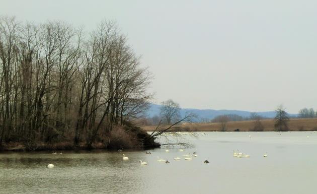
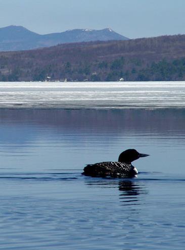
9 Very cold, oligo-mesotrophic, acidic lake Macrogroup: Lakes This map is based on a model and has had little field-checking. Contact your State Natural Heritage Ecologist or State Fish Game Agency for more information about this habitat. State Distribution: Total Surface Area (acres): 561,16 % Shoreline Conserved: CT, MA, ME, NH, NY, PA, RI, VA, VT, WV 32.6 Shoreline = 1m buffer State Surface # of Shoreline Shoreline Shoreline Area Waterbodies Reserve Multi-use Unsecured Shoreline Unit = 1m Unit buffer = 1m in acres buffer in (acres) (acres) (acres) (acres) acres ME 369, ,668 15,874 7,133 Description: Lake Sunapee, NH. PHOTO CREDIT: Rick Kloeppel (6). LICENSE: CC BY-SA 2.. A very cold, deep, acidic, clear lake characterized by high dissolved oxygen content and low to moderate levels of biological productivity. These are deep lakes where very cold, highly oxygenated water is present year round, usually in the deepest zone. Water alkalinity is low, supporting biota tolerant of acidic waters. In summer, these lakes may stratify into a warm upper layer (epilimnion) that supports warmwater fish species like largemouth bass and a cold lower layer (hypolimnion) that provides refuge for coldwater fish species like lake trout and brook trout. Thermal habitat for coolwater fish species like northern pike is present throughout. The degree to which the lake stratifies varies based on local conditions, and they usually remix in the spring and fall to create more uniform temperatures from surface to bottom. This lake type is typical of acidic substrates, northern latitudes, or deep kettle holes on the coastal plain. A few very deep reservoirs in the mid- Atlantic also support this habitat. The average lake in this category has a surface area of 962 acres and a depth of 68 feet. NH 82, ,443 17,954 NY 66, ,869 3,942 19,79 MA 31, ,837 2,585 VT 6, ,328 2,442 CT 2, ,312 RI Text213 PA WV Text4 VA Number of Waterbodies: 583 lakes Habitat Type Criteria: Coldest summer water temperature < 55F & dissolved oxygen > 5 mg/l. Calcium carbonate < 12.5 mg/l. Chlorophyll-a < 7 ug/l. Places to Visit this Habitat: Lake Winnipesaukee NH, Schoodic Lake ME, Lewey Lake NY, Sheep Pond MA, West Hill Pond CT
 and slimy sculpin. These lakes may also provide the thermal habitat required for both cool and warmwater fish species.")
10 Associated Species: This habitat may support very coldwater species such as lake trout (togue), in addition to other characteristic coldwater fish species such as rainbow smelt, brook trout, brown trout, landlocked Atlantic salmon, whitefish, burbot (cusk) and slimy sculpin. These lakes may also provide the thermal habitat required for both cool and warmwater fish species. Coolwater fish species include northern pike, walleye, smallmouth bass, white sucker, yellow perch, introduced white perch, banded killifish, creek chub, fallfish and common shiner. Warmwater fish species commonly include largemouth bass, several sunfish species (pumpkinseed, bluegill, redbreast sunfish), chain pickerel, American eel, brown bullhead and golden shiner. Very acidic lakes are likely to have low species richness, with the most acidic supporting brown bullhead-golden shiner assemblages in lieu of other fish species. Securement % Riparian Buffer Securement Class Unit = 1m riparian buffer Landcover Classes Species of Concern (G1 - G4): Fish: Landlocked Arctic Char Mussels: Yellow Lampmussel, Tidewater Mucket % of Riparian Buffer Developed Forest Unit = 1m riparian buffer Open/Grass Cultivated Wetland Temperature and Depth Profile FIGURE CREDIT: Katrine Turgeon (15) Dams by Primary Purpose % of Dams by Type (All Waterbodies) Flood Control Hydroelectric Recreation Water Supply Other Undammed Damariscotta Lake, ME. PHOTO CREDIT: Keith Carver (7). LICENSE: CC BY-NC-ND 2.. Watershed Impervious Characteristics % of Watersheds Class Very cold, oligo-mesotrophic, acidic lake

 (acres) (acres)")
11 Very cold, oligo-mesotrophic, neutral lake Macrogroup: Lakes This map is based on a model and has had little field-checking. Contact your State Natural Heritage Ecologist or State Fish Game Agency for more information about this habitat. State Distribution: Total Surface Area (acres): 189,559 % Shoreline Conserved: CT, MA, MD, ME, NH, NJ, NY, PA, VA, VT, WV 25.1 Shoreline = 1m buffer State Surface # of Shoreline Shoreline Shoreline Area Waterbodies Reserve Multi-use Unsecured Shoreline Unit = 1m Unit buffer = 1m in acres buffer in (acres) (acres) (acres) (acres) acres NY 67, ,243 1,31 14,8 Description: Lake Habeeb, MD. PHOTO CREDIT: javcon177 (12). LICENSE: CC BY-SA 2., cropped. A very cold, deep, circumneutral, clear lake characterized by high dissolved oxygen content and low to moderate levels of biological productivity. These are deep lakes where very cold, highly oxygenated water is present year round, usually in the deepest zone. Water alkalinity is medium, supporting biota tolerant of circumneutral waters. In summer, these lakes may stratify into a warm upper layer (epilimnion) that supports warmwater fish species like largemouth bass and a cold lower layer (hypolimnion) that provides refuge for coldwater fish species like lake trout and brook trout. Thermal habitat for coolwater fish species like northern pike is present throughout. The degree to which the lake stratifies varies based on local conditions, and they usually remix in the spring and fall to create more uniform temperatures from surface to bottom. This lake type is typical of neutral substrates, northern latitudes, or deep kettle holes on the coastal plain. A few very deep reservoirs in the mid-atlantic also support this habitat. The average lake in this category has a surface area of 18 acres and a depth of 77 feet. ME 66, ,73 2,417 16,269 VA 28, ,813,52 PA 1, ,245 1,98 3,884 VT 9, ,886 MD 4, , ,4 CT 1, Text213 WV NH Text4 NJ MA Number of Waterbodies: 188 lakes Habitat Type Criteria: Coldest summer water temperature < 55F & dissolved oxygen > 5 mg/l. Calcium carbonate 12.5 to 5 mg/l. Chlorophyll-a < 7 ug/l. Places to Visit this Habitat: Square Lake ME, Joe's Pond VT, Cork Center Reservoir NY, Lake Habeeb MD, Quaker Lake PA
 and slimy sculpin. These lakes may also provide the thermal habitat required for both cool and warmwater fish species.")
12 Associated Species: This habitat may support very cold water species such as lake trout (togue), in addition to other characteristic coldwater fish species such as rainbow smelt, brook trout, brown trout, landlocked Atlantic salmon, whitefish, burbot (cusk) and slimy sculpin. These lakes may also provide the thermal habitat required for both cool and warmwater fish species. Coolwater fish species include northern pike, walleye, smallmouth bass, white sucker, yellow perch, introduced white perch, banded killifish, creek chub, fallfish and common shiner. Warmwater fish species commonly include largemouth bass, several sunfish species (pumpkinseed, bluegill, redbreast sunfish), chain pickerel, American eel, brown bullhead and golden shiner. Securement % Riparian Buffer Securement Class Unit = 1m riparian buffer Landcover Classes Species of Concern (G1 - G4): Fish: Landlocked Arctic Char Mussels: James Spinymussel % of Riparian Buffer Developed Forest Unit = 1m riparian buffer Open/Grass Cultivated Wetland Temperature and Depth Profile FIGURE CREDIT: Katrine Turgeon (15) Dams by Primary Purpose % of Dams by Type (All Waterbodies) Flood Control Hydroelectric Recreation Water Supply Other Undammed Chazy Lake, NY. PHOTO CREDIT: yuan3 (8). LICENSE: CC BY-NC 2.. Watershed Impervious Characteristics % of Watersheds Class Very cold, oligo-mesotrophic, neutral lake

 (acres) (acres)")
13 Very cold, oligo-mesotrophic, alkaline lake Macrogroup: Lakes This map is based on a model and has had little field-checking. Contact your State Natural Heritage Ecologist or State Fish Game Agency for more information about this habitat. State Distribution: CT, MA, ME, NJ, NY, PA, VA, VT Total Surface Area (acres): 414,295 % Shoreline Conserved: 11.9 Shoreline = 1m buffer State Surface # of Shoreline Shoreline Shoreline Area Waterbodies Reserve Multi-use Unsecured Shoreline Unit = 1m Unit buffer = 1m in acres buffer in (acres) (acres) (acres) (acres) acres VT 271, ,3 2,38 21,818 Description: Wawayanda Lake, NJ. PHOTO CREDIT: Daniel X. Wang (13). LICENSE: CC BY- NC-ND 2.. A very cold, deep, alkaline, clear lake characterized by high dissolved oxygen content and low to moderate levels of biological productivity. These are deep lakes where very cold, highly oxygenated water is present year round, usually in the deepest zone. Water alkalinity is high, supporting biota tolerant of alkaline waters. In summer, these lakes may stratify into a warm upper layer (epilimnion) that supports warmwater fish species like largemouth bass and a cold lower layer (hypolimnion) that provides refuge for coldwater fish species like lake trout and brook trout. Thermal habitat for coolwater fish species like northern pike is present throughout. The degree to which the lake stratifies varies based on local conditions, and they usually remix in the spring and fall to create more uniform temperatures from surface to bottom. This lake type is typical of calcareous substrates at high elevations or northern latitudes. A few very deep reservoirs in the mid-atlantic also support this habitat. The average lake in this category has a surface area of 6,95 acres and a depth of 14 feet. NY 131, ,547 14,52 PA 8, ,346 VA 1, ,621 CT ME NJ Text213 MA Number of Waterbodies: 6 lakes Habitat Type Criteria: Coldest summer water temperature < 55F & dissolved oxygen > 5 mg/l. Calcium carbonate > 5 mg/l. Chlorophyll-a < 7 ug/l. Places to Visit this Habitat: Seneca Lake NY, Raystown Lake PA, Lake Bomoseen VT, Nickerson Lake ME, John W Flannagan Reservoir VA
 and slimy sculpin. These lakes may also provide the thermal habitat required for both cool and warmwater fish species.")
14 Associated Species: This habitat may support very cold water species such as lake trout (togue), in addition to other characteristic coldwater fish species such as rainbow smelt, brook trout, brown trout, landlocked Atlantic salmon, whitefish, burbot (cusk) and slimy sculpin. These lakes may also provide the thermal habitat required for both cool and warmwater fish species. Coolwater fish species include northern pike, walleye, smallmouth bass, white sucker, yellow perch, introduced white perch, banded killifish, creek chub, fallfish and common shiner. Warmwater fish species commonly include largemouth bass, several sunfish species (pumpkinseed, bluegill, redbreast sunfish), chain pickerel, American eel, brown bullhead and golden shiner. Securement % Riparian Buffer Securement Class Unit = 1m riparian buffer Landcover Classes Species of Concern (G1 - G4): Fish: Blacknose Shiner, Bridle Shiner % of Riparian Buffer Developed Forest Unit = 1m riparian buffer Open/Grass Cultivated Wetland Temperature and Depth Profile FIGURE CREDIT: Katrine Turgeon (15) Dams by Primary Purpose % of Dams by Type (All Waterbodies) Flood Control Hydroelectric Recreation Water Supply Other Undammed Canandaigua Lake, NY. PHOTO CREDIT: Lida (Barb; 6). LICENSE: CC BY-ND 2.. Watershed Impervious Characteristics % of Watersheds Class Very cold, oligo-mesotrophic, alkaline lake

 (acres) (acres)")
15 Very cold, eutrophic, acidic lake Macrogroup: Lakes This map is based on a model and has had little field-checking. Contact your State Natural Heritage Ecologist or State Fish Game Agency for more information about this habitat. State Distribution: MA, ME, NH, NY, PA Total Surface Area (acres): 5,359 % Shoreline Conserved: 32.6 Shoreline = 1m buffer State Surface # of Shoreline Shoreline Shoreline Area Waterbodies Reserve Multi-use Unsecured Shoreline Unit = 1m Unit buffer = 1m in acres buffer in (acres) (acres) (acres) (acres) acres NY 2, ME 2, PA Description: Quacumquasit Pond, MA. PHOTO CREDIT: carolineccb (12). LICENSE: CC BY 2., cropped. A very cold, deep, acidic lake characterized by high biological productivity and high concentrations of nitrogen and phosphorus. These are murky deep lakes where very cold oxygenated water is present year round, but these nutrient rich lakes have less dissolved oxygen than oligo-mesotrophic lakes because they support an abundance of plant and algae growth. Excess nutrients may be due to agricultural run-off or other human alterations. The water can be clear if aquatic plants predominate, but is often cloudy due to high algae content. Water alkalinity is low, supporting biota tolerant of acidic waters. In summer, these lakes may stratify into a warm upper layer (epilimnion) that supports warmwater fish species like largemouth bass and a cold lower layer (hypolimnion) that provides refuge for coldwater fish species like brook trout and possibly lake trout. Thermal habitat for coolwater fish species like northern pike is present throughout. The degree to which the lake stratifies varies based on local conditions, and they usually remix in the spring and fall to create more uniform temperatures from surface to bottom. This is an unusual lake type that may indicate highly altered conditions. The average lake in this category has a surface area of 315 acres and depth of 61 feet. MA NH Number of Waterbodies: 17 lakes Habitat Type Criteria: Coldest summer water temperature < 55F & dissolved oxygen > 5 mg/l. Calcium carbonate < 12.5 mg/l. Chlorophyll-a >7 ug/l. Places to Visit this Habitat: Harveys Lake PA, Quacumquasit Pond MA, Gilman Lake NY, Rum Pond ME
 and slimy sculpin. These lakes may also provide the thermal habitat required for both cool and warmwater fish species.")
16 Associated Species: This habitat may support very cold water species such as lake trout (togue), in addition to other characteristic coldwater fish species such as rainbow smelt, brook trout, brown trout, landlocked Atlantic salmon, whitefish, burbot (cusk) and slimy sculpin. These lakes may also provide the thermal habitat required for both cool and warmwater fish species. Coolwater fish species include northern pike, walleye, smallmouth bass, white sucker, yellow perch, introduced white perch, banded killifish, creek chub, fallfish and common shiner. Warmwater fish species commonly include largemouth bass, several sunfish species (pumpkinseed, bluegill, redbreast sunfish), chain pickerel, American eel, brown bullhead and golden shiner. Very acidic lakes are likely to have low species richness, with the most acidic supporting brown bullhead-golden shiner assemblages in lieu of other fish species. Securement % Riparian Buffer Securement Class Unit = 1m riparian buffer Landcover Classes Species of Concern (G1 - G4): None % of Riparian Buffer Developed Forest Unit = 1m riparian buffer Open/Grass Cultivated Wetland Temperature and Depth Profile FIGURE CREDIT: Katrine Turgeon (15) Dams by Primary Purpose % of Dams by Type (All Waterbodies) Flood Control Hydroelectric Recreation Water Supply Other Undammed Togus Pond, ME. PHOTO CREDIT: Doug Kerr (12). LICENSE: CC BY-SA 2.. Watershed Impervious Characteristics % of Watersheds Class Very cold, eutrophic, acidic lake

 (acres) (acres)")
17 Very cold, eutrophic, neutral lake Macrogroup: Lakes This map is based on a model and has had little field-checking. Contact your State Natural Heritage Ecologist or State Fish Game Agency for more information about this habitat. State Distribution: ME, NJ, NY, PA, VT Total Surface Area (acres): 19,45 % Shoreline Conserved: 4.7 Shoreline = 1m buffer State Surface # of Shoreline Shoreline Shoreline Area Waterbodies Reserve Multi-use Unsecured Shoreline Unit = 1m Unit buffer = 1m in acres buffer in (acres) (acres) (acres) (acres) acres ME 18, ,478 NY PA Description: Cobbosseecontee Lake, ME. PHOTO CREDIT: Chris Goldberg (12). LICENSE: CC BY-NC 2.. A very cold, deep, circumneutral lake characterized by high biological productivity and high concentrations of nitrogen and phosphorus. These are murky deep lakes where very cold oxygenated water is present year round, but these nutrient rich lakes have less dissolved oxygen than oligo-mesotrophic lakes because they support an abundance of plant growth. Excess nutrients may be due to agricultural run-off or other human alterations. The water can be clear if aquatic plants predominate, but is often cloudy due to high algae content. Water alkalinity is medium, supporting biota tolerant of neutral conditions. In summer, these lakes may stratify into a warm upper layer (epilimnion) that supports warmwater fish species like largemouth bass and a cold lower layer (hypolimnion) that provides refuge for coldwater fish species like brook trout and possibly lake trout. Thermal habitat for coolwater fish species like northern pike is present throughout. The degree to which the lake stratifies varies based on local conditions, and they usually remix in the spring and fall to create more uniform temperatures from surface to bottom. This is an unusual lake type that may indicate highly altered conditions. The average lake in this category has a surface area of 1,386 acres and a depth of 68 feet. VT NJ Number of Waterbodies: 14 lakes Habitat Type Criteria: Coldest summer water temperature < 55F & dissolved oxygen > 5 mg/l. Calcium carbonate 12.5 to 5 mg/l. Chlorophyll-a >7 ug/l. Places to Visit this Habitat: Cobbosseecontee Lake ME, Tuxedo Lake NY, Starlight Lake PA, Spruce Pond VT, East Lake NJ
18 Associated Species: This habitat may support very cold water species such as lake trout (togue), in addition to other characteristic coldwater fish species such as rainbow smelt, brook trout, brown trout, landlocked Atlantic salmon, whitefish, burbot (cusk) and slimy sculpin. These lakes may also provide the thermal habitat required for both cool and warmwater fish species. Coolwater fish species include northern pike, walleye, smallmouth bass, white sucker, yellow perch, introduced white perch, banded killifish, creek chub, fallfish and common shiner. Warmwater fish species commonly include largemouth bass, several sunfish species (pumpkinseed, bluegill, redbreast sunfish), chain pickerel, American eel, brown bullhead and golden shiner. Securement % Riparian Buffer Securement Class Unit = 1m riparian buffer Landcover Classes Species of Concern (G1 - G4): None % of Riparian Buffer Developed Forest Unit = 1m riparian buffer Open/Grass Cultivated Wetland Temperature and Depth Profile FIGURE CREDIT: Katrine Turgeon (15) Dams by Primary Purpose % of Dams by Type (All Waterbodies) Flood Control Hydroelectric Recreation Water Supply Other Undammed Sebasticook Lake, ME. PHOTO CREDIT: Jody Roberts (11). LICENSE: CC BY- NC-SA 2... Watershed Impervious Characteristics % of Watersheds Class Very cold, eutrophic, neutral lake

 (acres) (acres)")
19 Very cold, eutrophic, alkaline lake Macrogroup: Lakes This map is based on a model and has had little field-checking. Contact your State Natural Heritage Ecologist or State Fish Game Agency for more information about this habitat. State Distribution: NY, PA, VA Total Surface Area (acres): 8,17 % Shoreline Conserved: 49.6 Shoreline = 1m buffer State Surface # of Shoreline Shoreline Shoreline Area Waterbodies Reserve Multi-use Unsecured Shoreline Unit = 1m Unit buffer = 1m in acres buffer in (acres) (acres) (acres) (acres) acres VA 7, ,752 2,669 NY PA Description: Sylvan Lake, NY. PHOTO CREDIT: Brandi (8). LICENSE: CC BY 2., cropped and color-corrected. A very cold, deep, alkaline lake characterized by high biological productivity and high concentrations of nitrogen and phosphorus. These are murky deep lakes where very cold oxygenated water is present year round, but these nutrient rich lakes have less dissolved oxygen than oligo-mesotrophic lakes because they support an abundance of plant and algae growth. Excess nutrients may be due to agricultural run-off or other human alterations. The water can be clear if aquatic plants predominate, but is often cloudy due to high algae content. Water alkalinity is high, supporting biota tolerant of more alkaline conditions. In summer, these lakes may stratify into a warm upper layer (epilimnion) that supports warmwater fish species like largemouth bass and a cold lower layer (hypolimnion) that provides refuge for coldwater fish species like brook trout and possibly lake trout. Thermal habitat for coolwater fish species like northern pike is present throughout. The degree to which the lake stratifies varies based on local conditions, and they usually remix in the spring and fall to create more uniform temperatures from surface to bottom. This is an unusual lake type that may indicate highly altered conditions. The average lake in this category has a surface area of 2,4 acres and a depth of 118 feet. Number of Waterbodies: 4 lakes Habitat Type Criteria: Coldest summer water temperature < 55F & dissolved oxygen > 5 mg/l. Calcium carbonate > 5 mg/l. Chlorophyll-a >7 ug/l. Places to Visit this Habitat: Sylvan Lake NY, South Holston Lake VA, Lake Gleneida NY
 and slimy sculpin. These lakes may also provide the thermal habitat required for both cool and warmwater fish species.")
20 Associated Species: This habitat may support very cold water species such as lake trout (togue), in addition to other characteristic coldwater fish species such as rainbow smelt, brook trout, brown trout, landlocked Atlantic salmon, whitefish, burbot (cusk) and slimy sculpin. These lakes may also provide the thermal habitat required for both cool and warmwater fish species. Coolwater fish species include northern pike, walleye, smallmouth bass, white sucker, yellow perch, introduced white perch, banded killifish, creek chub, fallfish and common shiner. Warmwater fish species commonly include largemouth bass, several sunfish species (pumpkinseed, bluegill, redbreast sunfish), chain pickerel, American eel, brown bullhead and golden shiner. Securement % Riparian Buffer Securement Class Unit = 1m riparian buffer Landcover Classes Species of Concern (G1 - G4): None % of Riparian Buffer Developed Forest Unit = 1m riparian buffer Open/Grass Cultivated Wetland Temperature and Depth Profile FIGURE CREDIT: Katrine Turgeon (15) Dams by Primary Purpose % of Dams by Type (All Waterbodies) Flood Control Hydroelectric Recreation Water Supply Other Undammed South Holston Lake, VA. PHOTO CREDIT: Ben Collins. LICENSE: CC BY- NC 2.. Watershed Impervious Characteristics % of Watersheds Class Very cold, eutrophic, alkaline lake

 (acres) (acres)")
21 Cold, oligo-mesotrophic, acidic lake or pond Macrogroup: Lakes and Ponds This map is based on a model and has had little field-checking. Contact your State Natural Heritage Ecologist or State Fish Game Agency for more information about this habitat. State Distribution: CT, MA, ME, NH, NY, PA, VA, VT Total Surface Area (acres): 157,874 % Shoreline Conserved: 4. Shoreline = 1m buffer State Surface # of Shoreline Shoreline Shoreline Area Waterbodies Reserve Multi-use Unsecured Shoreline Unit = 1m Unit buffer = 1m in acres buffer in (acres) (acres) (acres) (acres) acres ME 127, ,715 23,547 67,543 NY 13, ,322 3,782 9,321 NH 12, ,97 3,737 1,364 VT 2, ,4 Description: Lake Cathance, ME. PHOTO CREDIT: Richard Wood (9). LICENSE: CC by 2.. A cold, acidic, clear lake or pond characterized by low to moderate levels of biological productivity. These are lakes or ponds where cold, oxygenated water is present year round, usually in the deepest zone. Water alkalinity is low, supporting biota tolerant of acidic waters. Very acidic waterbodies can be highly colored due to high dissolved organic carbon and organic acid content. In summer, these lakes may stratify into a warm upper layer (epilimnion) that supports warmwater fish species like largemouth bass and a cold lower layer (hypolimnion) that provides refuge for cold and coolwater fish species like brook trout, brown trout, and northern pike; conditions are not cold enough for lake trout. The degree to which the lake stratifies varies based on local conditions, and they usually remix in the spring and fall to create more uniform temperatures from surface to bottom. In contrast to lakes, shallow ponds are unlikely to stratify during the summer, and may freeze to the bottom of the pond in the winter. This waterbody type is typical of acidic substrates at high elevations or northern latitudes, such as the mountainous areas of the northeastern US. The average lake in this category has a surface area of 155 acres and a depth of 34 feet. The average pond in this category has a surface area of 22 acres and a depth of 8 feet. CT MA PA Text213 VA Number of Waterbodies: 737 lakes and 2,93 ponds Habitat Type Criteria: Coldest summer water temperature 55 to 64F & dissolved oxygen > 5 mg/l. Calcium carbonate < 12.5 mg/l. Chlorophyll-a < 7 ug/l. Places to Visit this Habitat: Lake Cathance ME, White Lake NY, Manning Lake NH, Beebe Pond VT, Beach Pond CT
 and slimy sculpin. These lakes may also provide the thermal habitat required for both cool and warmwater fish species.")
22 Associated Species: This habitat may support characteristic coldwater fish species (exclusive of lake trout), including rainbow smelt, brook trout, brown trout, landlocked Atlantic salmon, burbot (cusk) and slimy sculpin. These lakes may also provide the thermal habitat required for both cool and warmwater fish species. Coolwater fish species include northern pike, walleye, smallmouth bass, white sucker, yellow perch, introduced white perch, banded killifish, creek chub, fallfish and common shiner. Warmwater fish species commonly include largemouth bass, several sunfish species (pumpkinseed, bluegill, redbreast sunfish), chain pickerel, American eel, brown bullhead and golden shiner. Very acidic lakes are likely to have low species richness, with the most acidic supporting brown bullhead-golden shiner assemblages in lieu of other fish species. The vegetation in shallow waterbodies is likely to be dominated by water lilies, while the vegetation in larger deeper lakes is also likely to include floatingleaved and submerged mat-forming aquatics. Securement % Riparian Buffer Securement Class Unit = 1m riparian buffer Landcover Classes Species of Concern (G1 - G4): Mussels: Brook Floater % of Riparian Buffer Developed Forest Unit = 1m riparian buffer Open/Grass Cultivated Wetland Temperature and Depth Profile FIGURE CREDIT: Katrine Turgeon (15) Dams by Primary Purpose % of Dams by Type (All Waterbodies) Flood Control Hydroelectric Recreation Water Supply Other Undammed Swanzey Lake, NH. PHOTO CREDIT: Dipanjan Nath (9). LICENSE: CC BY- NC-ND 2.. Watershed Impervious Characteristics % of Watersheds Class Cold, oligo-mesotrophic, acidic lake or pond

 (acres) (acres)")
23 Cold, oligo-mesotrophic, neutral lake or pond Macrogroup: Lakes and Ponds This map is based on a model and has had little field-checking. Contact your State Natural Heritage Ecologist or State Fish Game Agency for more information about this habitat. State Distribution: Total Surface Area (acres): 81,26 % Shoreline Conserved: CT, MA, ME, NH, NJ, NY, PA, VA, VT, WV 27. Shoreline = 1m buffer State Surface # of Shoreline Shoreline Shoreline Area Waterbodies Reserve Multi-use Unsecured Shoreline Unit = 1m Unit buffer = 1m in acres buffer in (acres) (acres) (acres) (acres) acres ME 64, ,595 1,976 39,713 NY 5, ,327 1,28 7,422 NH 4, ,569 1,494 Description: Brant Lake, NY. PHOTO CREDIT: Diane Cordell (1). LICENSE: CC BY-NC-ND 2.. A cold, circumneutral, clear lake or pond characterized by low to moderate levels of biological productivity. These are lakes or ponds where cold, oxygenated water is present year round, usually in the deepest zone. Water alkalinity is medium, supporting biota tolerant of circumneutral waters. In summer, these lakes may stratify into a warm upper layer (epilimnion) that supports warmwater fish species like largemouth bass and a cold lower layer (hypolimnion) that provides refuge for cold and coolwater fish species like brook trout, brown trout, and northern pike; conditions are not cold enough for lake trout. The degree to which the lake stratifies varies based on local conditions, and they usually remix in the spring and fall to create more uniform temperatures from surface to bottom. In contrast to lakes, shallow ponds are unlikely to stratify during the summer, and may freeze to the bottom of the pond in the winter. This waterbody type is typical of neutral substrates at high elevations or northern latitudes, such as the mountainous areas of the northeastern US. The average lake in this category has a surface area of 248 acres and a depth of 38 feet. The average pond in this category has a surface area of 26 acres and reaches a maximum depth of 6 feet. NJ 2, CT 2, VT 1, ,173 PA Text213 VA WV Text4 MA Number of Waterbodies: 232 lakes and 945 ponds Habitat Type Criteria: Coldest summer water temperature 55 to 64F & dissolved oxygen > 5 mg/l. Calcium carbonate 12.5 to 5 mg/l. Chlorophyll-a < 7 ug/l. Places to Visit this Habitat: Upper Mattawamkeag Lake ME, Greenwood Lake VT, Brant Lake NY, Big Island Pond NH, Highland Lake CT
 and slimy sculpin. These lakes may also provide the thermal habitat required for both cool and warmwater fish species.")
24 Associated Species: This habitat may support characteristic coldwater fish species (exclusive of lake trout), including rainbow smelt, brook trout, brown trout, landlocked Atlantic salmon, burbot (cusk) and slimy sculpin. These lakes may also provide the thermal habitat required for both cool and warmwater fish species. Coolwater fish species include northern pike, walleye, smallmouth bass, white sucker, yellow perch, introduced white perch, banded killifish, creek chub, fallfish and common shiner. Warmwater fish species commonly include largemouth bass, several sunfish species (pumpkinseed, bluegill, redbreast sunfish), chain pickerel, American eel, brown bullhead and golden shiner. The vegetation in shallow waterbodies is likely to be dominated by water lilies, while the vegetation in larger deeper lakes is also likely to include floating-leaved and submerged mat-forming aquatics. Securement % Riparian Buffer Securement Class Unit = 1m riparian buffer Landcover Classes Species of Concern (G1 - G4): Fish: Landlocked Arctic Char Mussels: Brook Floater, Yellow Lampmussel % of Riparian Buffer Developed Forest Unit = 1m riparian buffer Open/Grass Cultivated Wetland Temperature and Depth Profile FIGURE CREDIT: Katrine Turgeon (15) Dams by Primary Purpose % of Dams by Type (All Waterbodies) Flood Control Hydroelectric Recreation Water Supply Other Undammed Eden Lake, VT. PHOTO CREDIT: Maurice Huang (7). LICENSE: CC BY-NC-ND 2., straightened. Watershed Impervious Characteristics % of Watersheds Class Cold, oligo-mesotrophic, neutral lake or pond

 (acres) (acres)")
25 Cold, oligo-mesotrophic, alkaline lake or pond Macrogroup: Lakes and Ponds This map is based on a model and has had little field-checking. Contact your State Natural Heritage Ecologist or State Fish Game Agency for more information about this habitat. State Distribution: CT, MA, ME, NJ, NY, PA, VT, WV Total Surface Area (acres): 4,391 % Shoreline Conserved: 11.2 Shoreline = 1m buffer State Surface # of Shoreline Shoreline Shoreline Area Waterbodies Reserve Multi-use Unsecured Shoreline Unit = 1m Unit buffer = 1m in acres buffer in (acres) (acres) (acres) (acres) acres NY 1, ,993 ME ,852 Description: Echo Lake, VT. PHOTO CREDIT: Willie Miller (11). LICENSE: CC BY-NC-SA 2.. A cold, alkaline, clear lake or pond characterized by low to moderate levels of biological productivity. These are lakes or ponds where cold, oxygenated water is present year round, usually in the deepest zone. Water alkalinity is high, supporting biota tolerant of alkaline waters. In summer, these lakes may stratify into a warm upper layer (epilimnion) that supports warmwater fish species like largemouth bass and a cold lower layer (hypolimnion) that provides refuge for cold and coolwater fish species like brook trout, brown trout, and northern pike; conditions are not cold enough for lake trout. The degree to which the lake stratifies varies based on local conditions, and they usually remix in the spring and fall to create more uniform temperatures from surface to bottom. In contrast to lakes, shallow ponds are unlikely to stratify during the summer, and may freeze to the bottom of the pond in the winter. This waterbody type is found on alkaline substrates. The average lake in this category has a surface area of 91 acres and a depth of 45 feet. The average pond in this category has a surface area of 14 acres and a depth of 6 feet. VT CT PA MA WV Text213 NJ Number of Waterbodies: 34 lakes and 88 ponds Habitat Type Criteria: Coldest summer water temperature 55 to 64F & dissolved oxygen > 5 mg/l. Calcium carbonate > 5 mg/l. Chlorophyll-a < 7 ug/l. Places to Visit this Habitat: Lake Koon PA, Spaulding Lake ME, Sabin Pond VT, Woodman Pond NY, Cub Lake NJ
 and slimy sculpin. These lakes may also provide the thermal habitat required for both cool and warmwater fish species.")
26 Associated Species: This habitat may support characteristic coldwater fish species (exclusive of lake trout), including rainbow smelt, brook trout, brown trout, landlocked Atlantic salmon, burbot (cusk) and slimy sculpin. These lakes may also provide the thermal habitat required for both cool and warmwater fish species. Coolwater fish species include northern pike, walleye, smallmouth bass, white sucker, yellow perch, introduced white perch, banded killifish, creek chub, fallfish and common shiner. Warmwater fish species commonly include largemouth bass, several sunfish species (pumpkinseed, bluegill, redbreast sunfish), chain pickerel, American eel, brown bullhead and golden shiner. The vegetation in shallow waterbodies is likely to be dominated by water lilies, while the vegetation in larger deeper lakes is also likely to include floating-leaved and submerged mat-forming aquatics. Securement % Riparian Buffer Securement Class Unit = 1m riparian buffer Landcover Classes Species of Concern (G1 - G4): None % of Riparian Buffer Developed Forest Unit = 1m riparian buffer Open/Grass Cultivated Wetland Temperature and Depth Profile FIGURE CREDIT: Katrine Turgeon (15) Dams by Primary Purpose % of Dams by Type (All Waterbodies) Flood Control Hydroelectric Recreation Water Supply Other Undammed Leland Pond, NY. PHOTO CREDIT: Carrie Nelson (11). LICENSE: CC BY- NC-ND 2.. Watershed Impervious Characteristics % of Watersheds Class Cold, oligo-mesotrophic, alkaline lake or pond

 (acres) (acres)")
27 Cold, eutrophic, acidic lake or pond Macrogroup: Lakes and Ponds This map is based on a model and has had little field-checking. Contact your State Natural Heritage Ecologist or State Fish Game Agency for more information about this habitat. State Distribution: MA, ME, NH, NY, PA, VT Total Surface Area (acres): 14,356 % Shoreline Conserved: 44.7 Shoreline = 1m buffer State Surface # of Shoreline Shoreline Shoreline Area Waterbodies Reserve Multi-use Unsecured Shoreline Unit = 1m Unit buffer = 1m in acres buffer in (acres) (acres) (acres) (acres) acres ME 7, ,171 5,116 NY 3, ,596 1,95 3,841 NH 3, ,81 6,476 PA MA Description: Pleasant Lake, ME. PHOTO CREDIT: Bob Travis (11). LICENSE: CC BY-NC 2.. A cold, acidic lake or pond characterized by high biological productivity and high concentrations of nitrogen and phosphorus. These are murky lakes and ponds where cold water is present year round, but these nutrient rich lakes have less dissolved oxygen than oligo-mesotrophic lakes because they support an abundance of plant and algae growth. Excess nutrients may be due to agricultural run-off or other human alterations. The water can be clear if aquatic plants predominate, but is often cloudy due to high algae content. Water alkalinity is low, supporting biota tolerant of acidic waters. Very acidic waterbodies can be highly colored due to high dissolved organic carbon and organic acid content. In summer, these lakes may stratify into a warm upper layer (epilimnion) that supports warmwater fish species like largemouth bass and a cold lower layer (hypolimnion) that provides refuge for cold and coolwater fish species like brook trout, brown trout, and northern pike; conditions are not cold enough for lake trout. The degree to which the lake stratifies varies based on local conditions, and they usually remix in the spring and fall to create more uniform temperatures from surface to bottom. In contrast to lakes, shallow ponds are unlikely to stratify during the summer, and may freeze to the bottom of the pond in the winter. This waterbody type isfound on acidic substrates at high elevations or northern latitudes. The average lake in this category has a surface area of 34 acres and a depth of 17 feet. The average pond in this category has a surface area of 1 acres and a depth of 5 feet. VT Number of Waterbodies: 8 lakes and 664 ponds Habitat Type Criteria: Coldest summer water temperature 55 to 64F & dissolved oxygen > 5 mg/l. Calcium carbonate < 12.5 mg/l. Chlorophyll-a >7 ug/l. Places to Visit this Habitat: Half Moon Pond ME, Neal Pond VT, Millsfield Pond NH, Uncas Pond MA, Duck Harbor Pond PA
 and slimy sculpin. These lakes may also provide the thermal habitat required for both cool and warmwater fish species.")
28 Associated Species: This habitat may support characteristic coldwater fish species (exclusive of lake trout), including rainbow smelt, brook trout, brown trout, landlocked Atlantic salmon, burbot (cusk) and slimy sculpin. These lakes may also provide the thermal habitat required for both cool and warmwater fish species. Coolwater fish species include northern pike, walleye, smallmouth bass, white sucker, yellow perch, introduced white perch, banded killifish, creek chub, fallfish and common shiner. Warmwater fish species commonly include largemouth bass, several sunfish species (pumpkinseed, bluegill, redbreast sunfish), chain pickerel, American eel, brown bullhead and golden shiner. Very acidic lakes are likely to have low species richness, with the most acidic supporting brown bullhead-golden shiner assemblages in lieu of other fish species. The vegetation in shallow waterbodies is likely to be dominated by water lilies, while the vegetation in larger deeper lakes is also likely to include floatingleaved and submerged mat-forming aquatics. Securement % Riparian Buffer Securement Class Unit = 1m riparian buffer Landcover Classes Species of Concern (G1 - G4): Mussel: Triangle Floater % of Riparian Buffer Developed Forest Unit = 1m riparian buffer Open/Grass Cultivated Wetland Temperature and Depth Profile FIGURE CREDIT: Katrine Turgeon (15) Dams by Primary Purpose % of Dams by Type (All Waterbodies) Flood Control Hydroelectric Recreation Water Supply Other Undammed Kettle Creek Lake, PA. PHOTO CREDIT: Nicholas A. Tonelli (8). LICENSE: CC BY 2.. Watershed Impervious Characteristics % of Watersheds Class Cold, eutrophic, acidic lake or pond

 (acres) (acres)")
29 Cold, eutrophic, neutral lake or pond Macrogroup: Lakes and Ponds This map is based on a model and has had little field-checking. Contact your State Natural Heritage Ecologist or State Fish Game Agency for more information about this habitat. State Distribution: \MA, ME, NH, NJ, NY, PA, VT Total Surface Area (acres): 13,56 % Shoreline Conserved: 19.6 Shoreline = 1m buffer State Surface # of Shoreline Shoreline Shoreline Area Waterbodies Reserve Multi-use Unsecured Shoreline Unit = 1m Unit buffer = 1m in acres buffer in (acres) (acres) (acres) (acres) acres ME 1, ,381 VT NH ,391 PA Description: Webber Pond, ME. PHOTO CREDIT: Movement Six (15). LICENSE: CC BY-NC 2.. A cold, circumneutral lake or pond characterized by high biological productivity and high concentrations of nitrogen and phosphorus. These are murky lakes and ponds where cold water is present year round, but these nutrient rich lakes have less dissolved oxygen than oligo-mesotrophic lakes because they support an abundance of plant and algae growth. Excess nutrients may be due to agricultural run-off or other human alterations. The water can be clear if aquatic plants predominate, but is often cloudy due to high algae content. Water alkalinity is medium, supporting biota tolerant of circumneutral waters. In summer, these lakes may stratify into a warm upper layer (epilimnion) that supports warmwater fish species like largemouth bass and a cold lower layer (hypolimnion) that provides refuge for cold and coolwater fish species like brook trout, brown trout, and northern pike; conditions are not cold enough for lake trout. The degree to which the lake stratifies varies based on local conditions, and they usually remix in the spring and fall to create more uniform temperatures from surface to bottom. In contrast to lakes, shallow ponds are unlikely to stratify during the summer, and may freeze to the bottom of the pond in the winter. This waterbody type is found on circumneutral substrates in northern latitudes. The average lake in this category has a surface area of 229 acres and a depth of 29 feet. The average pond in this category has a surface area of 13 acres and a depth of 5 feet. MA NY NJ Text213 Number of Waterbodies: 5 lakes and 155 ponds Habitat Type Criteria: Coldest summer water temperature 55 to 64F & dissolved oxygen > 5 mg/l. Calcium carbonate 12.5 to 5 mg/l. Chlorophyll-a >7 ug/l. Places to Visit this Habitat: Middle Pond MA, Beaver Lake NH, Sand Pond NY, Webber Pond ME, Fairfield Pond VT
 and slimy sculpin. These lakes may also provide the thermal habitat required for both cool and warmwater fish species.")
30 Associated Species: This habitat may support characteristic coldwater fish species (exclusive of lake trout), including rainbow smelt, brook trout, brown trout, landlocked Atlantic salmon, burbot (cusk) and slimy sculpin. These lakes may also provide the thermal habitat required for both cool and warmwater fish species. Coolwater fish species include northern pike, walleye, smallmouth bass, white sucker, yellow perch, introduced white perch, banded killifish, creek chub, fallfish and common shiner. Warmwater fish species commonly include largemouth bass, several sunfish species (pumpkinseed, bluegill, redbreast sunfish), chain pickerel, American eel, brown bullhead and golden shiner. The vegetation in shallow waterbodies is likely to be dominated by water lilies, while the vegetation in larger deeper lakes is also likely to include floating-leaved and submerged mat-forming aquatics. Securement % Riparian Buffer Securement Class Unit = 1m riparian buffer Landcover Classes Species of Concern (G1 - G4): Fish: Bridle Shiner Mussels: Tidewater Mucket, Yellow Lampmussel % of Riparian Buffer Developed Forest Unit = 1m riparian buffer Open/Grass Cultivated Wetland Temperature and Depth Profile FIGURE CREDIT: Katrine Turgeon (15) Dams by Primary Purpose % of Dams by Type (All Waterbodies) Flood Control Hydroelectric Recreation Water Supply Other Undammed Streeter Pond, NH. PHOTO CREDIT: Carleton Atwater (12). LICENSE: CC BY-NC-SA 2., color-corrected. Watershed Impervious Characteristics % of Watersheds Class Cold, eutrophic, neutral lake or pond

 (acres) (acres)")
31 Cold, eutrophic, alkaline lake or pond Macrogroup: Lakes and Ponds This map is based on a model and has had little field-checking. Contact your State Natural Heritage Ecologist or State Fish Game Agency for more information about this habitat. State Distribution: MA, ME, NH, NJ, NY, PA, VT Total Surface Area (acres): 3,918 % Shoreline Conserved: 4.2 Shoreline = 1m buffer State Surface # of Shoreline Shoreline Shoreline Area Waterbodies Reserve Multi-use Unsecured Shoreline Unit = 1m Unit buffer = 1m in acres buffer in (acres) (acres) (acres) (acres) acres NY 1, ,412 ME 1, ,654 VT MA Description: Lake Buel, MA. PHOTO CREDIT: Kingturtle. LICENSE: Public domain. A cold, alkaline lake or pond characterized by high biological productivity and high concentrations of nitrogen and phosphorus. These are murky lakes and ponds where cold water is present year round, but these nutrient rich lakes have less dissolved oxygen than oligo-mesotrophic lakes because they support an abundance of plant and algae growth. Excess nutrients may be due to agricultural run-off or other human alterations. The water can be clear if aquatic plants predominate, but is often cloudy due to high algae content. Water alkalinity is high, supporting biota tolerant of circumneutral waters. In summer, these lakes may stratify into a warm upper layer (epilimnion) that supports warmwater fish species like largemouth bass and a cold lower layer (hypolimnion) that provides refuge for refuge for cold and coolwater fish species like brook trout, brown trout, and northern pike; conditions are not cold enough for lake trout. The degree to which the lake stratifies varies based on local conditions, and they usually remix in the spring and fall to create more uniform temperatures from surface to bottom. In contrast to lakes, shallow ponds are unlikely to stratify during the summer, and may freeze to the bottom of the pond in the winter. This waterbody type is found on alkaline substrates in northern latitudes. The average lake in this category has a surface area of 65 acres and a depth of 26 feet. The average pond in this category has a surface area of 7 acres and a depth of 4 feet. NJ PA NH Text213 Number of Waterbodies: 37 lakes and 188 ponds Habitat Type Criteria: Coldest summer water temperature 55 to 64F & dissolved oxygen > 5 mg/l. Calcium carbonate > 5 mg/l. Chlorophyll-a >7 ug/l. Places to Visit this Habitat: Lake Parker VT, Monson Pond ME, Rushford Lake NY, Mountain Lake NJ, Lime Pond NH
 and slimy sculpin. These lakes may also provide the thermal habitat required for both cool and warmwater fish species.")
32 Associated Species: This habitat may support characteristic coldwater fish species (exclusive of lake trout), including rainbow smelt, brook trout, brown trout, landlocked Atlantic salmon, burbot (cusk) and slimy sculpin. These lakes may also provide the thermal habitat required for both cool and warmwater fish species. Coolwater fish species include northern pike, walleye, smallmouth bass, white sucker, yellow perch, introduced white perch, banded killifish, creek chub, fallfish and common shiner. Warmwater fish species commonly include largemouth bass, several sunfish species (pumpkinseed, bluegill, redbreast sunfish), chain pickerel, American eel, brown bullhead and golden shiner. The vegetation in shallow waterbodies is likely to be dominated by water lilies, while the vegetation in larger deeper lakes is also likely to include floating-leaved and submerged mat-forming aquatics. Securement % Riparian Buffer Securement Class Unit = 1m riparian buffer Landcover Classes Species of Concern (G1 - G4): Fish: Bridle Shiner % of Riparian Buffer Developed Forest Unit = 1m riparian buffer Open/Grass Cultivated Wetland Temperature and Depth Profile FIGURE CREDIT: Katrine Turgeon (15) Dams by Primary Purpose % of Dams by Type (All Waterbodies) Flood Control Hydroelectric Recreation Water Supply Other Undammed Trout, Debsconeag Lakes Wilderness Area, ME. PHOTO CREDIT: Rob Vogel. LICENSE: The Nature Conservancy. Watershed Impervious Characteristics % of Watersheds Class Cold, eutrophic, alkaline lake or pond

 (acres) (acres)")
33 Warm to cool, oligo-mesotrophic, acidic lake or pond Macrogroup: Lakes and Ponds This map is based on a model and has had little field-checking. Contact your State Natural Heritage Ecologist or State Fish Game Agency for more information about this habitat. State Distribution: Total Surface Area (acres): 466,842 % Shoreline Conserved: CT, DE, MA, MD, ME, NH, NJ, NY, PA, RI, VA, VT, WV 33.4 Shoreline = 1m buffer State Surface # of Shoreline Shoreline Shoreline Area Waterbodies Reserve Multi-use Unsecured Shoreline Unit = 1m Unit buffer = 1m in acres buffer in (acres) (acres) (acres) (acres) acres ME 24, ,833 16,362 96,286 Description: Plum Orchard Lake, WV. PHOTO CREDIT: Gene (14). LICENSE: CC BY-NC-ND 2.. A warm to cool, acidic lake or pond characterized by low to moderate levels of biological productivity. These are lakes and ponds where warm to cool, somewhat oxygenated water is present year round. Water alkalinity is low, supporting biota tolerant of acidic waters and these waterbodies may support beds of submerged aquatic vegetation. Very acidic waterbodies can be highly colored due to high dissolved organic carbon and organic acid content. Lakes of this type are relatively shallow compared to colder lakes in the region, and generally support warmwater fish like largemouth bass and sunfish. Cooler examples may support coolwater fish species like northern pike, but these lakes and ponds are unlikely to contain the dissolved oxygen and thermal habitat requirements suitable for coldwater fish. These lakes are located on acidic substrates in temperate regions. The average lake in this category has a surface area of 357 acres and a depth of 32 feet. The average pond in this category has a surface area of 43 acres and a depth of 8 feet. NY 78, ,38 12,919 35,331 NH 53, ,4 7,897 3,697 MA 4, ,271 11,64 23,345 RI 12, ,962 6,526 CT 1, ,993 8,76 NJ 8, ,546 2,269 5,886 Text213 VA 5, , ,511 PA 5, ,53 1,596 3,599 Text4 MD 4, ,445 2,157 2,729 VT 4, ,867 3,365 WV 1, ,549 DE , Number of Waterbodies: Cool: 541 lakes & 3 ponds; Warm: 398 lakes & 2,713 ponds Habitat Type Criteria: Cool: Coldest summer water temperature 64-7F & dissolved oxygen > 4 mg/l. Warm: Coldest summer water temperature >7F. Calcium carbonate < 12.5 mg/l. Chlorophyll-a < 7 ug/l. Places to Visit this Habitat: Carr Pond RI, Lake Sabbatia MA, Alligator Lake ME, Bashan Lake CT, Lake Raponda VT

34 Associated Species: Warmwater fish species commonly found in this habitat include largemouth bass, several sunfish species (pumpkinseed, bluegill, redbreast sunfish), chain pickerel, American eel, brown bullhead and golden shiner. Cooler examples of this habitat may support characteristic coolwater fish species including northern pike, walleye, smallmouth bass, white sucker, yellow perch, introduced white perch, banded killifish, creek chub, fallfish and common shiner. Very acidic lakes are likely to have low species richness, with the most acidic supporting brown bullhead-golden shiner assemblages in lieu of other fish species. The shallower waterbodies are often dominated by submersed macrophytes such as pondweeds, bladderword, watermilfoil, naiad, and Elodea in the phototrophic zone. Securement % Riparian Buffer Securement Class Unit = 1m riparian buffer Landcover Classes Species of Concern (G1 - G4): Fish: Bridle Shiner Mussels: Tidewater Mucket, Yellow Lampmussel, Eastern Pondmussel, Triangle Floater Reptiles: Northern Red-bellied Cooter % of Riparian Buffer Developed Forest Unit = 1m riparian buffer Open/Grass Cultivated Wetland Temperature and Depth Profile FIGURE CREDIT: Katrine Turgeon (15) Dams by Primary Purpose % of Dams by Type (All Waterbodies) Flood Control Hydroelectric Recreation Water Supply Other Undammed Jenness Pond, NH. PHOTO CREDIT: Rose Vines (1). LICENSE: CC BY- NC 2.. Watershed Impervious Characteristics % of Watersheds Class Warm to cool, oligo-mesotrophic, acidic lake or pond

 (acres) (acres)")
35 Warm to cool, oligo-mesotrophic, neutral lake or pond Macrogroup: Lakes and Ponds This map is based on a model and has had little field-checking. Contact your State Natural Heritage Ecologist or State Fish Game Agency for more information about this habitat. State Distribution: Total Surface Area (acres): 248,73 % Shoreline Conserved: CT, DE, MA, MD, ME, NH, NJ, NY, PA, RI, VA, VT, WV 27.3 Shoreline = 1m buffer State Surface # of Shoreline Shoreline Shoreline Area Waterbodies Reserve Multi-use Unsecured Shoreline Unit = 1m Unit buffer = 1m in acres buffer in (acres) (acres) (acres) (acres) acres NY 81, ,138 7,445 32,642 Description: Great Sacandaga Lake, NY. PHOTO CREDIT: Scott Saghirian (8). LICENSE: CC BY 2.. A warm to cool, circumneutral, clear lake or pond characterized by low to moderate levels of biological productivity. These are lakes and ponds where warm to cool, somewhat oxygenated water is present year round. Water alkalinity is medium, supporting biota tolerant of circumneutral waters and these waterbodies may support beds of submerged aquatic vegetation. Lakes of this type are relatively shallow compared to colder lakes in the region, and generally support warmwater fish like largemouth bass and sunfish. Cooler examples may support coolwater fish species like northern pike, but are unlikely to contain the dissolved oxygen and thermal habitat requirements suitable for coldwater fish. These lakes are located on circumneutral substrates in temperate regions. The average lake in this category has a surface area of 363 acres and a depth of 36 feet. The average pond in this category has a surface area of 3 acres and a depth of 8 feet. VA 47, ,78 2,583 3,794 ME 38, , 1,63 21,1 WV 16, ,273 8,577 PA 13, ,937 2,458 11,6 MA 12, ,71 6,774 MD 1, ,144 2,353 4,78 Text213 CT 8, ,472 8,145 VT 6, ,11 6,856 Text4 NJ 4, , ,114 RI 4, ,36 NH 3, ,99 DE Number of Waterbodies: Cool: 267 lakes & 111 ponds; Warm: 275 lakes & 1,581 ponds Habitat Type Criteria: Cool: Coldest summer water temperature 64-7F & dissolved oxygen > 4 mg/l. Warm: Coldest summer water temperature >7F. Calcium carbonate < 12.5 to 5 mg/l. Chlorophyll-a < 7 Places to Visit this Habitat: Tygart Lake WV, Lovell Lake NH, Twin Island Lake NY, Lake Mishnock RI, Pleasant Lake Stetson ME

36 Associated Species: Warmwater fish species commonly found in this habitat include largemouth bass, several sunfish species (pumpkinseed, bluegill, redbreast sunfish), chain pickerel, American eel, brown bullhead and golden shiner. This habitat may support characteristic coolwater fish species including northern pike, walleye, smallmouth bass, white sucker, yellow perch, introduced white perch, banded killifish, creek chub, fallfish and common shiner. The shallower waterbodies are often dominated by submersed macrophytes such as pondweeds, bladderword, watermilfoil, naiad, and Elodea in the phototrophic Securement % Riparian Buffer Securement Class Unit = 1m riparian buffer Landcover Classes Species of Concern (G1 - G4): Fish: Bridle Shiner, Ohio Lamprey, Ironcolor Shiner Mussels: Brook Floater, Tidewater Mucket, Yellow Lampmussel, Eastern Pondmussel % of Riparian Buffer Developed Forest Unit = 1m riparian buffer Open/Grass Cultivated Wetland Temperature and Depth Profile FIGURE CREDIT: Katrine Turgeon (15) Dams by Primary Purpose % of Dams by Type (All Waterbodies) Flood Control Hydroelectric Recreation Water Supply Other Undammed Lake Kanasatka, NH. PHOTO CREDIT: foreverseptember (9). LICENSE: CC BY-ND 2.. Watershed Impervious Characteristics % of Watersheds Class Warm to cool, oligo-mesotrophic, neutral lake or pond

37 Warm to cool, oligo-mesotrophic, alkaline lake or pond Macrogroup: Lakes and Ponds This map is based on a model and has had little field-checking. Contact your State Natural Heritage Ecologist or State Fish Game Agency for more information about this habitat. State Distribution: Total Surface Area (acres): 114,469 % Shoreline Conserved: CT, MA, MD, ME, NH, NJ, NY, PA, RI, VA, VT, WV.8 Shoreline = 1m buffer State Surface # of Shoreline Shoreline Shoreline Area Waterbodies Reserve Multi-use Unsecured Shoreline Unit = 1m Unit buffer = 1m in acres buffer in (acres) (acres) (acres) (acres) acres NY 76, ,922 18,248 Description: Canadarago Lake, NY. PHOTO CREDIT: Keturah Stickann (7). LICENSE: CC BY- NC-ND 2.. A warm to cool, alkaline, clear lake or pond characterized by low to moderate levels of biological productivity. These are lakes and ponds where warm to cool, somewhat oxygenated water is present year round. Water alkalinity is high, supporting biota tolerant of alkaline waters, and these waterbodies may support beds of submerged aquatic vegetation. Lakes of this type are relatively shallow compared to colder lakes in the region, and generally support warmwater fish like largemouth bass and sunfish. Cooler examples may support coolwater fish species like northern pike, but these lakes and ponds are unlikely to contain the dissolved oxygen and thermal habitat requirements suitable for coldwater fish. These lakes are located on calcareous substrates in temperate regions. The average lake in this category has a surface area of 838 acres and reaches a maximum depth of 42 feet. The average pond in this category has a surface area of 3 acres and a depth of 9 feet. PA 11, ,584 VT 1, ,119 1,275 7,479 CT 8, ,51 VA 3, ,74 MA 1, NJ 1, Text213 RI WV Text4 ME MD 1 4 Number of Waterbodies: Cool: 6 lakes & 36 ponds; Warm: 61 lakes & 4 ponds Habitat Type Criteria: Cool: Coldest summer water temperature 64-7F & dissolved oxygen > 4 mg/l. Warm: Coldest summer water temperature >7F. Calcium carbonate > 5 mg/l. Chlorophyll-a < 7 ug/l. Places to Visit this Habitat: Canadarago Lake NY, Hardwick Lake VT, Wononpakook Lake CT, Spruce Run Reservoir NJ, Lake Bonaventure VA

38 Associated Species: Warmwater fish species commonly found in this habitat include largemouth bass, several sunfish species (pumpkinseed, bluegill, redbreast sunfish), chain pickerel, American eel, brown bullhead and golden shiner. Cooler examples of this habitat may support characteristic coolwater fish species including northern pike, walleye, smallmouth bass, white sucker, yellow perch, introduced white perch, banded killifish, creek chub, fallfish and common shiner. The shallower waterbodies are often dominated by submersed macrophytes such as pondweeds, bladderword, watermilfoil, naiad, Elodea and algae such as Chara in the phototrophic zone. Securement % Riparian Buffer Securement Class Unit = 1m riparian buffer Landcover Classes Species of Concern (G1 - G4): Fish: Bridle Shiner, Lake Sturgeon Mussels: James Spinymussel % of Riparian Buffer Developed Forest Unit = 1m riparian buffer Open/Grass Cultivated Wetland Temperature and Depth Profile FIGURE CREDIT: Katrine Turgeon (15) Dams by Primary Purpose % of Dams by Type (All Waterbodies) Flood Control Hydroelectric Recreation Water Supply Other Undammed Lake Champlain, VT. PHOTO CREDIT: Jay Parker (1). LICENSE: CC BY-NC 2.. Watershed Impervious Characteristics % of Watersheds Class Warm to cool, oligo-mesotrophic, alkaline lake or pond

 (acres) (acres)")
39 Warm to cool, eutrophic, acidic lake or pond Macrogroup: Lakes and Ponds This map is based on a model and has had little field-checking. Contact your State Natural Heritage Ecologist or State Fish Game Agency for more information about this habitat. State Distribution: Total Surface Area (acres): 9,369 % Shoreline Conserved: CT, DE, MA, MD, ME, NH, NJ, NY, PA, RI, VA, VT, WV 25.4 Shoreline = 1m buffer State Surface # of Shoreline Shoreline Shoreline Area Waterbodies Reserve Multi-use Unsecured Shoreline Unit = 1m Unit buffer = 1m in acres buffer in (acres) (acres) (acres) (acres) acres MA 32, ,94 9,92 42,78 NY 12, ,165 5,22 17,335 NH 11, ,29 15,364 NJ 8, ,45 1,59 13,83 Description: Green Pond, NJ. PHOTO CREDIT: Kd5463 (6). LICENSE: CC BY-SA 3.. A warm to cool, acidic lake or pond characterized by high biological productivity and high concentrations of nitrogen and phosphorus. These are murky lakes and ponds where warm to cool, somewhat oxygenated water is present year round. Water alkalinity is low, supporting biota tolerant of acidic waters. Very acidic waterbodies can be highly colored due to high dossolved organic carbon and organic acid content. These high nutrient lakes are likely to support a diverse array of organisms and an abundance of plant and algae growth. Excess nutrients may be due to agricultural runoff or other human alterations. Hypereutrophic lakes can also be dominated by vegetative overgrowth and algal blooms, resulting in low biodiversity, dark water with poor visibility, and anoxic conditions ( dead zones ). Lakes of this type are relatively shallow compared to colder lakes in the region, and generally support warmwater fish like largemouth bass and sunfish. Cooler examples may support coolwater fish species like northern pike, but these lakes and ponds are unlikely to contain the dissolved oxygen and thermal habitat requirements suitable for coldwater fish. These lakes are located on acidic substrates in temperate regions. The average lake in this category has a surface area of 52 acres and a depth of 17 feet. The average pond in this category has a surface area of 16 acres and a depth of 5 feet. CT 6, ,431 1,727 ME 6, ,781 PA 6, ,352 1,94 5,382 Text213 RI 3, ,735 VT ,51 Text4 MD VA DE WV Number of Waterbodies: Cool: 99 lakes & 47 ponds; Warm: 77 lakes and 2,95 ponds Habitat Type Criteria: Cool: Coldest summer water temperature 64-7F & dissolved oxygen > 4 mg/l. Warm: Coldest summer water temperature >7F. Calcium carbonate < 12.5 mg/l. Chlorophyll-a >7 ug/l. Places to Visit this Habitat: Halfway Pond MA, Sewell Pond ME, Perkins Pond NH, Artist Lake NY, Pocotopaug Lake CT

40 Associated Species: Warmwater fish species commonly found in this habitat include largemouth bass, several sunfish species (pumpkinseed, bluegill, redbreast sunfish), chain pickerel, American eel, brown bullhead and golden shiner. Cooler examples of this habitat may support characteristic coolwater fish species including northern pike, walleye, smallmouth bass, white sucker, yellow perch, introduced white perch, banded killifish, creek chub, fallfish and common shiner. Very acidic lakes are likely to have low species richness, with the most acidic supporting brown bullhead-golden shiner assemblages in lieu of other fish species. The shallower waterbodies are often dominated by submersed macrophytes such as pondweeds, bladderword, watermilfoil, naiad, and Elodea in the phototrophic zone. Securement % Riparian Buffer Securement Class Unit = 1m riparian buffer Landcover Classes Species of Concern (G1 - G4): Fish: Bridle Shiner Mussels: Tidewater Mucket, Eastern Pondmussel, Triangle Floater Reptile: Northern Red-bellied Cooter % of Riparian Buffer Developed Forest Unit = 1m riparian buffer Open/Grass Cultivated Wetland Temperature and Depth Profile FIGURE CREDIT: Katrine Turgeon (15) Dams by Primary Purpose % of Dams by Type (All Waterbodies) Flood Control Hydroelectric Recreation Water Supply Other Undammed Shohola Marsh Reservoir, PA. PHOTO CREDIT: Jason (9). LICENSE: CC BY-NC-ND 2.. Watershed Impervious Characteristics % of Watersheds Class Warm to cool, eutrophic, acidic lake or pond

41 Warm to cool, eutrophic, neutral lake or pond Macrogroup: Lakes and Ponds This map is based on a model and has had little field-checking. Contact your State Natural Heritage Ecologist or State Fish Game Agency for more information about this habitat. State Distribution: Total Surface Area (acres): 376,54 % Shoreline Conserved: CT, DC, DE, MA, MD, ME, NH, NJ, NY, PA, RI, VA, VT, WV 15.5 Shoreline = 1m buffer State Surface # of Shoreline Shoreline Shoreline Area Waterbodies Reserve Multi-use Unsecured Shoreline Unit = 1m Unit buffer = 1m in acres buffer in (acres) (acres) (acres) (acres) acres VA 119, , ,493 PA 84, ,417 9,626 87,968 NY 37, ,87 8,721 51,525 Description: Lake Quannapowitt, MA. PHOTO CREDIT: Alex1961 (13). LICENSE: CC BY-SA 2., straightened and color-corrected. A warm to cool, circumneutral lake or pond characterized by high biological productivity and high concentrations of nitrogen and phosphorus. These are murky lakes and ponds where warm to cool, somewhat oxygenated water is present year round. Water alkalinity is medium, supporting biota tolerant of circumneutral waters. These high nutrient lakes are likely to support a diverse array of organisms and an abundance of plant and algae growth. Excess nutrients may be due to agricultural run-off or other human alterations. Hypereutrophic lakes can also be dominated by vegetative overgrowth and algal blooms, resulting in low biodiversity, dark water with poor visibility, and anoxic conditions ( dead zones ). Lakes of this type are relatively shallow compared to colder lakes in the region, and generally support warmwater fish like largemouth bass and sunfish. Cooler examples may support coolwater fish species like northern pike, but these lakes and ponds are unlikely to contain the dissolved oxygen and thermal habitat requirements suitable for coldwater fish. These lakes are located on circumneutral substrates in temperate regions. The average lake in this category has a surface area of 92 acres and a depth of 18 feet. The average pond in this category has a surface area of 12 acres and a depth of 4 feet. MA 31, ,748 43,263 NJ 27, ,823 2,788 37,229 MD 18, ,26 6,15 24,843 CT 18, ,98 3,931 32,1 Text213 DE 1, ,212 3,928 12,686 ME 8, ,149 Text4 WV 7, ,867 7,732 RI 5, ,18 8,463 NH 3, ,84 7,45 VT 2, ,528 DC Number of Waterbodies: Cool: lakes & 86 ponds; Warm: 2,111 lakes & 11,688 ponds Habitat Type Criteria: Cool: Coldest summer water temperature 64-7F & dissolved oxygen > 4 mg/l. Warm: Coldest summer water temperature >7F. Calcium carbonate < 12.5 to 5 mg/l. Chlorophyll-a >7 Places to Visit this Habitat: Bantam Lake CT, Lake Carmi VT, Pinchot Lake PA, Johnsons Pond MD, Belleville Pond RI

42 Associated Species: Warmwater fish species commonly found in this habitat include largemouth bass, several sunfish species (pumpkinseed, bluegill, redbreast sunfish), chain pickerel, American eel, brown bullhead and golden shiner. Cooler examples of this habitat may support characteristic coolwater fish species including northern pike, walleye, smallmouth bass, white sucker, yellow perch, introduced white perch, banded killifish, creek chub, fallfish and common shiner. The shallower waterbodies are often dominated by submersed macrophytes such as pondweeds, bladderword, watermilfoil, naiad, and Elodea in the phototrophic zone. Securement % Riparian Buffer Securement Class Unit = 1m riparian buffer Landcover Classes Species of Concern (G1 - G4): Fish: Ohio Lamprey, Blackbanded Sunfish, Ironcolor Shiner Mussels: Green Floater, Eastern Pondmussel % of Riparian Buffer Developed Forest Unit = 1m riparian buffer Open/Grass Cultivated Wetland Temperature and Depth Profile FIGURE CREDIT: Katrine Turgeon (15) Dams by Primary Purpose % of Dams by Type (All Waterbodies) Flood Control Hydroelectric Recreation Water Supply Other Undammed Lake Ronkonkoma, NY. PHOTO CREDIT: Joe Shlabotnik (7). LICENSE: CC BY 2.. Watershed Impervious Characteristics % of Watersheds Class Warm to cool, eutrophic, neutral lake or pond

 (acres) (acres)")
43 Warm to cool, eutrophic, alkaline lake or pond Macrogroup: Lakes and Ponds This map is based on a model and has had little field-checking. Contact your State Natural Heritage Ecologist or State Fish Game Agency for more information about this habitat. State Distribution: Total Surface Area (acres): 194,785 % Shoreline Conserved: CT, DE, MA, MD, ME, NH, NJ, NY, PA, RI, VA, VT, WV 13.5 Shoreline = 1m buffer State Surface # of Shoreline Shoreline Shoreline Area Waterbodies Reserve Multi-use Unsecured Shoreline Unit = 1m Unit buffer = 1m in acres buffer in (acres) (acres) (acres) (acres) acres NY 16, ,56 11,54 16,41 PA 5, ,221 4,459 43,6 NJ 16, , ,322 Description: Pymatuning Swamp, PA. PHOTO CREDIT: Shannon (12). LICENSE: CC BY-NC-ND 2.. A warm to cool, alkaline lake or pond characterized by high biological productivity and high concentrations of nitrogen and phosphorus. These are murky lakes and ponds where warm to cool, somewhat oxygenated water is present year round. Water alkalinity is high, supporting biota tolerant of alkaline waters. These high nutrient lakes are likely to support a diverse array of organisms and an abundance of plant and algae growth. Excess nutrients may be due to agricultural run-off or other human alterations. Hypereutrophic lakes can also be dominated by vegetative overgrowth and algal blooms, resulting in low biodiversity, dark water with poor visibility, and anoxic conditions ( dead zones ). Lakes of this type are relatively shallow compared to colder lakes in the region, and generally support warmwater fish like largemouth bass and sunfish. Cooler examples may support coolwater fish species like northern pike, but these lakes and ponds are unlikely to contain the dissolved oxygen and thermal habitat requirements suitable for coldwater fish. These lakes are located on calcareous substrates in temperate regions. The average lake in this category has a surface area of 126 acres and a depth of 19 feet. The average pond in this category has a surface area of 12 acres and reaches a maximum depth of 4 feet. VA 5, ,265 CT 4, ,5 7,63 VT 3, ,145 WV 2, ,761 Text213 MA 2, ,52 MD 1, ,715 Text4 DE ,224 ME RI NH Number of Waterbodies: Cool: 72 lakes & 36 ponds; Warm: 888 lakes & 4,776 ponds Habitat Type Criteria: Cool: Coldest summer water temperature 64-7F & dissolved oxygen > 4 mg/l. Warm: Coldest summer water temperature >7F. Calcium carbonate > 5 mg/l. Chlorophyll-a >7 ug/l. Places to Visit this Habitat: Cross Lake NY, Shelburne Pond VT, Colonial Lake NJ, Pymatuning Swamp PA, Lake Kittamaqundi MD

44 Associated Species: Warmwater fish species commonly found in this habitat include largemouth bass, several sunfish species (pumpkinseed, bluegill, redbreast sunfish), chain pickerel, American eel, brown bullhead and golden shiner. Cooler examples of this habitat may support characteristic coolwater fish species including northern pike, walleye, smallmouth bass, white sucker, yellow perch, introduced white perch, banded killifish, creek chub, fallfish and common shiner. The vegetation in shallow waterbodies is likely to be dominated by water lilies, while the vegetation in larger deeper lakes is also likely to include floating-leaved and submerged mat-forming aquatics. Securement % Riparian Buffer Securement Class Unit = 1m riparian buffer Landcover Classes Species of Concern (G1 - G4): Fish: Lake Sturgeon, Pugnose Shiner, Blacknose Shiner, Ironcolor Shiner Mussels: Clubshell % of Riparian Buffer Developed Forest Unit = 1m riparian buffer Open/Grass Cultivated Wetland Temperature and Depth Profile FIGURE CREDIT: Katrine Turgeon (15) Dams by Primary Purpose % of Dams by Type (All Waterbodies) Flood Control Hydroelectric Recreation Water Supply Other Undammed Shelburne Pond, VT. PHOTO CREDIT: Dean J. Williams (11). LICENSE: CC BY-NC-ND 2.. Watershed Impervious Characteristics % of Watersheds Class Warm to cool, eutrophic, alkaline lake or pond
Keuka Lake State of the Lake 2017
 Keuka Lake State of the Lake 2017 1 2 Lake Characteristics Third largest by area of the Finger Lakes 11,730 ac Deep and steep sided - max 185 ft mean 101 ft Two story fishery (warmwater/coldwater) 178,800
Thunder Bay River Assessment Appendix. Appendix 2
 Appendix 2 Known past and present fish distributions in the River system. Distribution of fishes were compiled from Bailey et al. (2003) and from records located at the Michigan Department of Natural Resources
Target Fish Communities and the MA Water Policy
 Target Fish Communities and the MA Water Policy Todd Richards MA Division of Fisheries and Wildlife Todd.Richards@state.ma.us MA Water Policy (2004) Principle: Protect Fish and Wildlife Habitat Recommendation:
Proposed Reclassification of Cherry Creek, North Platte River Basin, Wyoming. October 25, 2010
 Proposed Reclassification of Cherry Creek, North Platte River Basin, Wyoming October 25, 2010 Waterbody: Location: Tributary to: Cherry Creek - Mainstem from headwaters downstream to the confluence with
6TH PELLETIER BROOK LAKE T15 R9, Aroostook Co. U.S.G.S. Gardner Pond, Maine (7 1/2 )
") 6TH PELLETIER BROOK LAKE T15 R9, Aroostook Co. U.S.G.S. Gardner Pond, Maine (7 1/2 ) Fishes Brook trout Minnows Blacknose dace Pearl dace Physical Characteristics Area - 27 acres Average depth - 2 feet
6TH PELLETIER BROOK LAKE T15 R9, Aroostook Co. U.S.G.S. Gardner Pond, Maine (7 1/2 ) Fishes Brook trout Minnows Blacknose dace Pearl dace Physical Characteristics Area - 27 acres Average depth - 2 feet
Importance of Temperature and Flow for Fish in Connecticut Streams
 Importance of Temperature and Flow for Fish in Connecticut Streams Chris Bellucci, CT DEEP Water Monitoring and Assessment Program Climate Change Conference, Litchfield, CT September 23, 2016 Today s Talk
Fish Community. Fish Habitat, Streams and Rivers
 Clear, Ston(e)y and White Lake Plan Fish Community The lakes support a cool/warm water fishery including muskellunge, walleye, largemouth and smallmouth bass, yellow perch, pumpkinseed, rockbass, blue
Fish Survey of Arctic Lake (ID # ), Scott County, Minnesota in 2012
, Scott County, Minnesota in 2012") Snapping Turtle from Arctic Lake, September 2012 Fish Survey of Arctic Lake (ID #70-0085), Scott County, Minnesota in 2012 Survey Dates: September 18-20, 2012 MnDNR Permit Number: 18362 Prepared for: Shakopee
Snapping Turtle from Arctic Lake, September 2012 Fish Survey of Arctic Lake (ID #70-0085), Scott County, Minnesota in 2012 Survey Dates: September 18-20, 2012 MnDNR Permit Number: 18362 Prepared for: Shakopee
Crooked Lake Oakland County (T4N, R9E, Sections 3, 4, 9) Surveyed May James T. Francis
 Surveyed May James T. Francis") Michigan Department of Natural Resources Status of the Fishery Resource Report No. 2004-1, 2004 Crooked Lake Oakland County (T4N, R9E, Sections 3, 4, 9) Surveyed May 2002 James T. Francis Environment Crooked
Michigan Department of Natural Resources Status of the Fishery Resource Report No. 2004-1, 2004 Crooked Lake Oakland County (T4N, R9E, Sections 3, 4, 9) Surveyed May 2002 James T. Francis Environment Crooked
Columbia Lake Dam Removal Project
 Columbia Lake Dam Removal Project The Columbia Lake dam located 1/4 mile upstream of the Paulins Kill River's confluence with the Delaware River in Knowlton Township, Warren County has been proposed for
Fisheries Survey of Saratoga Lake
 Fisheries Survey of Saratoga Lake 7- Mark D. Cornwell Kevin Poole State University of New York College of Agriculture & Technology Department of Fisheries & Wildlife Cobleskill, NY ABSTRACT: This survey
NJ DIVISION OF FISH AND WILDLIFE Bureau of Freshwater Fisheries
 NJ DIVISION OF FISH AND WILDLIFE Bureau of Freshwater Fisheries 2015 Warmwater Reproduction Checks (Shoreline Seining) Alloway Lake (Salem) A seining survey was completed at Alloway Lake (120 acres) on
BIG TWIN LAKE Kalkaska County (T28N, R05W, Section 18, and T28N, R06W, Section 13) Surveyed May 1999
 Surveyed May 1999") Michigan Department of Natural Resources Status of the Fishery Resource Report No. 2001-1, Year 2001 BIG TWIN LAKE Kalkaska County (T28N, R05W, Section 18, and T28N, R06W, Section 13) Surveyed May 1999
Michigan Department of Natural Resources Status of the Fishery Resource Report No. 2001-1, Year 2001 BIG TWIN LAKE Kalkaska County (T28N, R05W, Section 18, and T28N, R06W, Section 13) Surveyed May 1999
Proposed Reclassification of Horse Creek, North Platte River Basin in Goshen County, Wyoming
 Proposed Reclassification of Horse Creek, North Platte River Basin in Goshen County, Wyoming October 25, 2010 Waterbody: Location: Tributary to: Horse Creek - Mainstem from the confluence with Stinking
Proposed Reclassification of Deer Creek, North Platte River Basin, Wyoming
 Proposed Reclassification of Deer Creek, North Platte River Basin, Wyoming October 25, 2010 Waterbody: Location: Tributary to: Deer Creek - Mainstem from headwaters downstream to the confluence with the
Tahquamenon River Assessment Appendix
 DNR DEPARTMENT OF NATURAL RESOURCES MICHIGAN STATE OF MICHIGAN DEPARTMENT OF NATURAL RESOURCES SR45 Appendix February 2008 Tahquamenon River Assessment Appendix James R. Waybrant and Troy G. Zorn www.michigan.gov/dnr/
Onondaga Lake Fishery: 2011 Fact Sheet
 October, 2011 Onondaga County Department of Water Environment Protection SUNY College of Environmental Science and Forestry Joanne M. Mahoney, County Executive Tom Rhoads, P.E., Commissioner Onondaga Lake
Minnesota Department of Natural Resources Division of Fish and Wildlife Section of Fisheries. Stream Survey Report. Three Mile Creek 2011
 Minnesota Department of Natural Resources Division of Fish and Wildlife Section of Fisheries Stream Survey Report Three Mile Creek 2011 By Joseph D. Stewig Montrose Area Fisheries Office TABLE OF CONTENTS
ADOPT-A-STREAM WATERSHED APPROACH COMMUNITY-BASED STEWARDSHIP. Nova Scotia Salmon Association March 2005
 ADOPT-A-STREAM A WATERSHED APPROACH TO COMMUNITY-BASED STEWARDSHIP Nova Scotia Salmon Association March 2005 This manual is a revised and updated version of the 1994 Adopt-a-Stream manual that was prepared
Job 1 Part JOB 1, PART 2: SUMMARY OF CONOWINGO DAM WEST FISH LIFT OPERATIONS, 2009
 2.0 JOB 1, PART 2: SUMMARY OF CONOWINGO DAM WEST FISH LIFT OPERATIONS, 2009 Lawrence M. Miller Normandeau Associates U. S. Fish and Wildlife Service 1921 River Road Harrisburg, Pennsylvania Drumore, Pennsylvania
Archer Lake 2011 Survey Report Prepared by Brian Gunderman
 Archer Lake 211 Survey Report Prepared by Brian Gunderman Introduction Archer Lake is a 64 acre lake located about miles southeast of the city of Coldwater. Archer Lake is part of the Coldwater-Marble
Elk Lake, Antrim and Grand Traverse counties T. 28, 29 N., R. 8, 9 W., Sec. many. Lake surveys. began at 40 feet
 Elk Lake, Antrim and Grand Traverse counties T. 28, 29 N., R. 8, 9 W., Sec. many Physical and chemical data surveyed August 1931 Temperature ( F) Secchi disk (feet) 9. 6 Surface 74 Bottom 45 PH 8.0 Thermocline
Quemahoning Reservoir
 Pennsylvania Fish & Boat Commission Biologist Report Quemahoning Reservoir Somerset County May 2011 Trap Net, Gill Net and Electrofishing Survey Quemahoning Reservoir is an 899 acre impoundment located
Co-operative Freshwater Ecology Unit 2004 Program
 Co-operative Freshwater Ecology Unit 2004 Program Nordic Fish Survey (2003 + 2004) A survey of fish communities present in 25 Sudbury lakes was performed using the international standard Nordic Method.
Michigan Dept. of Natural Resources Status of the Fishery Resource Report Page 1. Weber Lake Cheboygan County, T34N, R3W, Sec.
 Michigan Dept. of Natural Resources 2012-143 Status of the Fishery Resource Report Page 1 Weber Lake Cheboygan County, T34N, R3W, Sec. 31 Neal Godby, Fisheries Biologist Environment Weber Lake is a 28.5-acre
MISSISSIPPI MAKEOVER A Plan for Restoration, Just Around the Bend
 MISSISSIPPI MAKEOVER A Plan for Restoration, Just Around the Bend Interim Report Card 2013 Project coordinated by the Dakota County Soil and Water Conservation District and sponsored by the Minnesota Pollution
REC 6 FISHERIES HABITAT EVALUATION
 REC 6 FISHERIES HABITAT EVALUATION 1.0 EXECUTIVE SUMMARY Analysis of fisheries habitat for recreational angling opportunities was completed by reviewing the results of the CAWG 1, Characterize Stream and
EXECUTIVE SUMMARY. Muskegon River Watershed Assessment
 EXECUTIVE SUMMARY This assessment for the Muskegon River watershed is one of a series being prepared by Michigan Department of Natural Resources, Fisheries Division, for river basins in Michigan. This
Fisheries Survey of White Rapids Flowage, Marinette County Wisconsin during Waterbody Identification Code
 Fisheries Survey of White Rapids Flowage, Marinette County Wisconsin during 25 Waterbody Identification Code 6343 Michael Donofrio Fisheries Supervisor Wisconsin Department of Natural Resources Peshtigo,
Holderness. The Three Watersheds within the Newfound Lake Drainage Dorchester. Groton Plymouth. Ashland. Hebron. Canaan. Bridgewater.
 Background Brook trout are the only native stream dwelling trout species in New Hampshire, having a historic range that extended from Georgia to eastern Canada. It is believed that wild brook trout were
Great Lakes Coastal Wetland Communities: Vulnerabilities to Climate Change and Response to Adaptation Strategies
 Great Lakes Coastal Wetland Communities: Vulnerabilities to Climate Change and Response to Adaptation Strategies CCAF Wetlands Study Investigators: Susan Doka Fisheries & Oceans, Great Lakes Lab for Fisheries
EcoLogic Memorandum. TO: Ben Brezell; EDR FROM: Mark Arrigo RE: Possible Impacts of Dredging Snooks Pond DATE: 6/4/07
 EcoLogic Memorandum TO: Ben Brezell; EDR FROM: Mark Arrigo RE: Possible Impacts of Dredging Snooks Pond DATE: 6/4/07 Background EDR P.C. (EDR) has been contracted by a landowner to assess the feasibility
Indiana Administrative Code Page IAC Aquaculture permit Authority: IC Affected: IC Sec. 17. (a) A person must not
 A person must not") Indiana Administrative Code Page 71 312 IAC 9-10-17 Aquaculture permit Affected: IC 14-22-27 Sec. 17. (a) A person must not import, raise, sell, or transport fish into or within Indiana without an aquaculture
Indiana Administrative Code Page 71 312 IAC 9-10-17 Aquaculture permit Affected: IC 14-22-27 Sec. 17. (a) A person must not import, raise, sell, or transport fish into or within Indiana without an aquaculture
Management of Small Impoundments
 Management of Small Impoundments Chapter 12 (Lake food webs) Chapter 15 (Natural Lakes) Chapter 16 (Farm Ponds & Small Impoundments) Quote for today: "The gods do not deduct from man's allotted span the
December 18, Dear Sir/Madam,
 December 18, 2000 Dear Sir/Madam, We are writing to bring you up-to-date on our efforts to develop fish community objectives for the St. Lawrence River. First of all, we want to thank you for participating
Montgomery Parks Biological Monitoring in the Anacostia Watershed of Montgomery County RESOURCE ANALYSIS SECTION
 Montgomery Parks Biological Monitoring in the Anacostia Watershed of Montgomery County PARK PLANNING & STEWARDSHIP Doug Redmond, Natural Resources Manager Montgomery County Department of Parks September
Pennsylvania Fish & Boat Commission Biologist Report. Wilmore Dam. Cambria County. May 2011 Trap Net, Electrofishing and Hoop Net Survey
 Pennsylvania Fish & Boat Commission Biologist Report Wilmore Dam Cambria County May 2011 Trap Net, Electrofishing and Hoop Net Survey Wilmore Dam is a 195 acre impoundment located in central Cambria County
Fish Survey of Goose Lake (ID # ), Ramsey County, Minnesota in 2012
, Ramsey County, Minnesota in 2012") Softshell Turtle from Goose Lake, July 2012 Fish Survey of Goose Lake (ID #62-0034), Ramsey County, Minnesota in 2012 Survey Dates: July 16-18, 2012 MnDNR Permit Number: 18362 Prepared for: VLAWMO and
Softshell Turtle from Goose Lake, July 2012 Fish Survey of Goose Lake (ID #62-0034), Ramsey County, Minnesota in 2012 Survey Dates: July 16-18, 2012 MnDNR Permit Number: 18362 Prepared for: VLAWMO and
FISH ASSEMBLAGE ASSESSMENT
 Relicensing Study 3.3.11 FISH ASSEMBLAGE ASSESSMENT Updated Study Report Summary Northfield Mountain Pumped Storage Project No. 2485) and Turners Falls Hydroelectric Project No. 1889) Prepared for: Prepared
Aquatic Plant Management and Importance to Sport Fisheries
 Aquatic Plant Management and Importance to Sport Fisheries Presentation to Michigan Inland Lakes Convention May 2014 Mike Maceina Professor Emeritus School of Fisheries, Aquaculture, and Aquatic Sciences
Alcona Dam Pond Alcona County (T25N, R5E, Sections various) Surveyed June 6-12 and September 16, 2003
 Surveyed June 6-12 and September 16, 2003") Michigan Department of Natural Resources Status of the Fishery Resource Report No. 2004-6, Year 2004 Alcona Dam Pond Alcona County (T25N, R5E, Sections various) Surveyed June 6-12 and September 16, 2003
Michigan Department of Natural Resources Status of the Fishery Resource Report No. 2004-6, Year 2004 Alcona Dam Pond Alcona County (T25N, R5E, Sections various) Surveyed June 6-12 and September 16, 2003
Rainbow Smelt. Appendix A: Fish. Osmerus mordax. New Hampshire Wildlife Action Plan Appendix A Fish-125
 Rainbow Smelt Osmerus mordax Federal Listing State Listing Global Rank State Rank Regional Status SC S3 Photo by John Lyons Justification (Reason for Concern in NH) Rainbow smelt were once harvested by
SUMMARY REPORT FOR LAKE ST. MALO FISHERIES ASSESSMENT. Prepared for the St. Malo and District Wildlife Association
 SUMMARY REPORT FOR LAKE ST. MALO FISHERIES ASSESSMENT Prepared for the St. Malo and District Wildlife Association Presented by August 25, 2014 Study dates thus far: Date Tasks February 16 Fishing derby;
Removal of natural obstructions to improve Atlantic Salmon and Brook Trout habitat in western NL. 26/02/2015 Version 2.0
 Removal of natural obstructions to improve Atlantic Salmon and Brook Trout habitat in western NL 26/02/2015 Version 2.0 1 Table of Contents List of Tables... 2 Introduction... 3 Methods... 4 Preliminary
Caro Impoundment, Tuscola County
 Caro Impoundment is a 200 acre impoundment of the Cass River located one mile south of the Village of Caro in Tuscola County. Caro Dam, originally constructed in 1906 for water supply to Michigan Sugar
Swift Current Creek Watershed
 Swift Current Creek Watershed Watershed Boundary Gross drainage area 3939 km 2 973,343 acres Gross creek length 230 km 143 miles Primary water source for 20 000 people Major source of water base recreation
JOB 1, PART 2. SUMMARY OF CONOWINGO DAM WEST FISH LIFT OPERATIONS 2011
 JOB 1, PART 2. SUMMARY OF CONOWINGO DAM WEST FISH LIFT OPERATIONS 2011 Michael L. Hendricks Pennsylvania Fish and Boat Commission 1735 Shiloh Rd. State College, Pa 16801 INTRODUCTION The shore-based trapping
Banded Sunfish. Appendix A: Fish. Enneacanthus obesus. New Hampshire Wildlife Action Plan Appendix A Fish-71
 Banded Sunfish Enneacanthus obesus Federal Listing State Listing Global Rank State Rank Regional Status SC S3 V. High Photo by NHFG Justification (Reason for Concern in NH) Surveys conducted since the
Geology. Key Factors. Overfishing. Great Lakes Fishes. Historical Fishing. About 10,000 years since last glacial retreat very young ecologically
 Great Lakes Fishes Geology About 10,000 years since last glacial retreat very young ecologically Largest surface freshwater system on earth 21% of world s supply 84% of North America s supply Five unique
2018 New Hampshire Envirothon: Fish and Wildlife Test. 1. barred owl 13. Canada lynx. 2. bobolink 14. porcupine. 3. spring peeper 15.
 2018 New Hampshire Envirothon: Fish and Wildlife Test Score: Team #: Section I - Wildlife Identification (25 points - 1 point each) Calls Mammals 1. barred owl 13. Canada lynx 2. bobolink 14. porcupine
HUBBARD LAKE Alcona County (T27N, R7E; T28N, R7E) Surveyed May and September Tim A. Cwalinski
 Surveyed May and September Tim A. Cwalinski") Michigan Department of Natural Resources Status of the Fishery Resource Report No. 2003-1, 2003 HUBBARD LAKE Alcona County (T27N, R7E; T28N, R7E) Surveyed May and September 1996 Tim A. Cwalinski Environment
Michigan Department of Natural Resources Status of the Fishery Resource Report No. 2003-1, 2003 HUBBARD LAKE Alcona County (T27N, R7E; T28N, R7E) Surveyed May and September 1996 Tim A. Cwalinski Environment
Lake Trout. Appendix A: Fish. Salvelinus namaycush. New Hampshire Wildlife Action Plan Appendix A Fish-158
 Lake Trout Salvelinus namaycush Federal Listing State Listing Global Rank State Rank Regional Status S5 High Photo by NHFG Justification (Reason for Concern in NH) Native populations of lake trout were
Finescale Dace. Appendix A: Fish. Chrosomus neogaeus. New Hampshire Wildlife Action Plan Appendix A Fish-60
 Finescale Dace Chrosomus neogaeus Federal Listing State Listing Global Rank State Rank Regional Status SC S3 Photo by John Lyons Justification (Reason for Concern in NH) Finescale dace are vulnerable to
SUMMARY OF CONOWINGO DAM WEST FISH LIFT OPERATIONS 2012
 SUMMARY OF CONOWINGO DAM WEST FISH LIFT OPERATIONS 2012 Michael L. Hendricks Pennsylvania Fish and Boat Commission 1735 Shiloh Rd. State College, Pa 16801 INTRODUCTION The shore-based trapping device at
Report prepared for: Prepared by: January 2002 BEAK Ref
 AQUATIC ENVIRONMENTAL STUDY KANATA WEST CONCEPT PLAN Report prepared for: ROBINSON CONSULTANTS Prepared by: BEAK INTERNATIONAL INCORPORATED 14 Abacus Road Brampton, Ontario L6T 5B7 January 2002 BEAK Ref.
Water Habitat Model. Outcome: Materials: Teacher Instructions: : Identify the components of an animal habitat..
 Water Habitat Model Outcome: 4-1-03: Identify the components of an animal habitat.. Materials: Shoe boxes (1 per student) Art supplies: Glue and/or tape Paint and brushes for the background Plasticine/clay
LAKE MANAGEMENT PLAN
 LAKE MANAGEMENT PLAN Region Area DOW Number County DOW Lake Name Acreage 2 Duluth F213 69-0041 St. Louis Bassett DOW: 436 Plan: 442 Long Range Goal: Manage for walleye with a gillnet catch rate greater
Rat Cove and Brookwood Point littoral fish survey, 2002
 Rat Cove and Brookwood Point littoral fish survey, 2 Katie Wayman 1 INTRODUCTION During the summer of 2, efforts to monitor the Otsego Lake littoral fish community continued with trap netting at both Rat
Warmwater Fisheries Assessments 2014
 NJDEP Division of Fish and Wildlife Bureau of Freshwater Fisheries Warmwater Fisheries Assessments 2014 New Jersey has over 400 impoundments open to the general public for fishing and thousands more in
Booklet translated by SREJ at CSDC 1
 Name: Gr. : Booklet translated by SREJ at CSDC 1 This is the beginning of a new project about Aquaculture. Before we start, I would like to see what you already know about the subject. Write all the words
Sebec Lake Fisheries Management Plan 2012
 Sebec Lake Fisheries Management Plan 2012 Sebec Lake is a 6,800-acre oligotrophic lake located in northwestern Maine. It has popular fisheries for landlocked salmon, lake trout, and smallmouth bass. Other
Michigan Department of Natural Resources Status of the Fishery Resource Report Page 1
 Michigan Department of Natural Resources 2007-33 Status of the Fishery Resource Report Page 1 Grand Sable Lake Alger County, T49N, R14W, Sec. Many Lake Superior watershed, last year surveyed 2004 James
Methods for Evaluating Shallow Water Habitat Restoration in the St. Clair River
 Methods for Evaluating Shallow Water Habitat Restoration in the St. Clair River Objectives Document fish use of restoration sites Spawning Presence of larvae, juvenile, and adult fish Quantify differences
CARL BLACKWELL LAKE MANAGEMENT PLAN
 CARL BLACKWELL LAKE MANAGEMENT PLAN Background Lake Carl Blackwell impounds Stillwater Creek, 10 miles west of Stillwater in Payne County, Oklahoma (Figure 1). The lake covers 3,370 surface acres and was
Rolling Knolls Pond Population Survey
 Located near the town of Elgin on the west side of Rohrssen Rd. between Illinois Route 58 and U.S.- 20. This small 1.8 acre pond has a maximum depth of 7.5 feet and is occasionally influenced by Poplar
Appendix 2. Miscellaneous Historical Creel Data. References
 Appendix 2 Miscellaneous Historical Creel Data This appendix contains miscellaneous creel data from 1928-1964 for the Kalamazoo River and tributaries. Angler hours, catch by species, total catch, catch
NEVADA DEPARTMENT OF WILDLIFE STATEWIDE FISHERIES MANAGEMENT
 NEVADA DEPARTMENT OF WILDLIFE STATEWIDE FISHERIES MANAGEMENT FEDERAL AID JOB PROGRESS REPORTS F-20-52 2016 EAST FORK AND MAIN STEM CARSON RIVER WESTERN REGION NEVADA DEPARTMENT OF WILDLIFE, FISHERIES DIVISION
The Fish Fauna of Cranberry Bog, Town of Burlington, Otsego County, N.Y.
 80 The Fish Fauna of Cranberry Bog, Town of Burlington, Otsego County, N.Y. Steven M. Foster* ABSTRACT In June 1995 a baseline fish survey of Cranberry Bog was conducted in order to identify the species
Delaware River Seine Survey: 2012 Sampling Summary
 Delaware River Seine Survey: 2012 Sampling Summary Fish and Wildlife employees pull in the seine net From June 18 to November 21, 2012, biologists conducted the Delaware River Seine Survey. Over the course
 example, the abundance of a given fish species in a basin can be validly estimated using the MBSS design. Because first, second, and third order streams represent about 90% of the tidal and non-tidal stream
Bode Lake - South Population Survey
 Bode Lake - South Survey Located in Hoffman Estates on the north side of Bode Rd. 1 mile west of Barrington Rd. Bode Lake is made up of two lakes along Poplar Creek; the larger and deeper Bode Lake South
MEMORANDUM Comfort Lake-Forest Lake Watershed District
 MEMORANDUM Comfort Lake-Forest Lake Watershed District To: Board of Managers Date: December 7, 2016 From: Mike Kinney Subject: 2016 Watercraft Inspections and AIS Report Summaries Watercraft Inspection
Claytor Lake View of the Claytor Lake dam from Claytor Lake State Park s boat ramp.
 Claytor Lake 2007 Imagine yourself on a waterbody that is more like a wide river than a lake. When you do, you will have a picture of Claytor Lake. Claytor Lake, a 4,475-acre reservoir, stretches northeastward
Penny Road Pond Population Survey
 Located in Barrington Hills on the south side of Penny Rd. west of Old Sutton Rd. This small 7 acre pond has a maximum depth of 4.6 feet and is connected to Spring Creek. The fish population of Penny Road
Lake information report
 Page of 5 Lake information report Name: Whitewater Nearest Town: Hoyt Lakes Primary County: St. Louis Survey Date: 08/3/2007 Inventory Number: 69037600 Public Access Information Ownership Type Description
Busse Reservoir South Lateral Pool Population Survey
 Busse Reservoir South Lateral Pool Survey Located in Elk Grove Village south of Higgins Rd. between RT 53/I-290 and Arlington Heights Rd. Busse Reservoir is comprised of three pools making up a total of
Adapting to Climate Change In Coastal Environments
 Adapting to Climate Change In Coastal Environments Peter Nimmrichter, P.Eng. AMEC Earth and Environmental, Mississauga, Ontario 19/11/2007 1 The Great Lakes Watershed The Great Lakes cover an area of 244,160
Cedar Lake Comprehensive Survey Report Steve Hogler and Steve Surendonk WDNR-Mishicot
 Cedar Lake- 2006 Comprehensive Survey Report Steve Hogler and Steve Surendonk WDNR-Mishicot ABSTRACT Cedar Lake is a 142 acre lake located in the southwest corner of Manitowoc County. It is a seepage lake
Summary of and Initial Response to public comments on MN Department of Natural Resources proposal to manage new waters for Muskellunge
 Summary of and Initial Response to public comments on MN Department of Natural Resources proposal to manage new waters for Muskellunge Summary of and Initial Response to public comments: This document
Michigan Dept. of Natural Resources Status of the Fishery Resource Report Page 1
 Michigan Dept. of Natural Resources 2014-197 Status of the Fishery Resource Report Page 1 Otter Lake Lapeer and Genesee Counties, T9,10N/R8,9E/ Sections 1,6,7,36 Flint River Watershed, Last surveyed 2014
Overview of Recreational Pond Management
 Overview of Recreational Pond Management extension November 13 th 2013 Forrest Wynne State Extension Specialist for Aquaculture Kentucky State University Ponds are built for some of the following purposes:
NEVADA DEPARTMENT OF WILDLIFE STATEWIDE FISHERIES MANAGEMENT
 NEVADA DEPARTMENT OF WILDLIFE STATEWIDE FISHERIES MANAGEMENT FEDERAL AID JOB PROGRESS REPORTS F-20-48 2012 LAKE TAHOE WESTERN REGION Contents NEVADA DEPARTMENT OF WILDLIFE, FISHERIES DIVISION ANNUAL PROGRESS
Northwest Montana Lakes Volunteer Monitoring Network 2015 Program Summary 5.7 SMALL LAKES. (Surface Area <100 Acres)
") 5.7 SMALL LAKES (Surface Area
5.7 SMALL LAKES (Surface Area
2014 Island Lake Survey June 13 th, 2014 Andrew Plauck District Fisheries Biologist Report Prepared 4 March 2015
 2014 Island Lake Survey June 13 th, 2014 Andrew Plauck District Fisheries Biologist Report Prepared 4 March 2015 BACKGROUND - A fish survey was requested due to a moderately severe winterkill in Island
CORRESPONDENCE/MEMORANDUM
 CORRESPONDENCE/MEMORANDUM State of Wisconsin DATE: November 13, 2012 FILE REF: [Click here and type file ref.] TO: FROM: Mike Donofrio Harpt Lake File Steve Hogler SUBJECT: 2012 Harpt Lake Electrofishing
WFC 50 California s Wild Vertebrates Jan. 11, Inland Waters (Lakes and Streams) Lisa Thompson
 Lisa Thompson") Inland Waters: Lakes and Streams WFC 50 11 January 2011 Lisa Thompson Fisheries Extension Specialist Wildlife, Fish, & Conservation Biology Department University of California, Davis Take home messages
Inland Waters: Lakes and Streams WFC 50 11 January 2011 Lisa Thompson Fisheries Extension Specialist Wildlife, Fish, & Conservation Biology Department University of California, Davis Take home messages
ASSESSMENT OF BLACK CRAPPIE AND WHITE PERCH IN HIGHLAND LAKE, STODDARD-WASHINGTON, NH (2014) New Hampshire
 New Hampshire") ASSESSMENT OF BLACK CRAPPIE AND WHITE PERCH IN HIGHLAND LAKE, STODDARD-WASHINGTON, NH (2014) STATE: GRANT: GRANT TITLE: JOB 9: New Hampshire F-50-R-31 Anadromous and Inland Fisheries Operational Management
ASSESSMENT OF BLACK CRAPPIE AND WHITE PERCH IN HIGHLAND LAKE, STODDARD-WASHINGTON, NH (2014) STATE: GRANT: GRANT TITLE: JOB 9: New Hampshire F-50-R-31 Anadromous and Inland Fisheries Operational Management
JadEco, LLC PO BOX 445 Shannon, IL 61078
 Introduction: With the assistance of Lake Holiday staff and volunteers, we were able to conduct an AC electrofishing survey on May 8, 27. Water temperatures were 2.3 C (8.5 F) and water clarity was decent
MIDDLE FORK RESERVOIR Wayne County 2004 Fish Management Report. Christopher C. Long Assistant Fisheries Biologist
 MIDDLE FORK RESERVOIR Wayne County 2004 Fish Management Report Christopher C. Long Assistant Fisheries Biologist FISHERIES SECTION INDIANA DEPARTMENT OF NATURAL RESOURCES DIVISION OF FISH AND WILDLIFE
Student Worksheet: River Health and Indicator Species
 1 Student Worksheet: River Health and Indicator Species Mink frogs (Lithobates septentrionalis). Credit: Allan G. Austin Activity 1: Biodiversity and Indicator Species Watch the videothe Importance of
Status of Lake Erie s Western Basin Fish Populations: Trends and Environmental Conditions
 Status of Lake Erie s Western Basin Fish Populations: Trends and Environmental Conditions Jeff Tyson Ohio Department of Natural Resources Ohio Division of Wildlife Status of the Lake Erie s Western Basin
I Region I Area I DOW Number / County I DOW Lake Name I Acreage I
 LAKE MANAGEMENT PLAN 814 Bp I Region I Area I DOW Number / County I DOW Lake Name I Acreage I I I # I f 2 Duluth F213 690036 St Louis Salo DOW:149 Plan: 137 Long Range Goal: Manage for walleye with a gillnet
Cold-transitional Small River
 Cold-transitional Small River A Brief Ecological Description of this Michigan River Type Cold-transitional Small River segments are defined (by the Michigan Department of Natural Resources, Fisheries Division)
FISH COMMUNITIES AND FISHERIES OF THE THOUSAND ISLANDS AND MIDDLE CORRIDOR
 St. Lawrence River Discussion Paper FISH COMMUNITIES AND FISHERIES OF THE THOUSAND ISLANDS AND MIDDLE CORRIDOR Issues Below is a synopsis of fish community issues and proposed management approaches. More
Trip Report: Eagle Creek, Arizona
 Trip Report: Eagle Creek, Arizona 15-17 June 2009 Participants: Abraham Karam, Brian Kesner, and Mike Childs Native Fish Lab Marsh & Associates, LLC 5016 South Ash Avenue Suite 108 Tempe, Arizona 85282
Cool (or Warm-transitional) Stream
 Stream") Cool (or Warm-transitional) Stream A Brief Ecological Description of this Michigan River Type Cool Stream segments are defined (by the Michigan Department of Natural Resources, Fisheries Division) as typically
Cool (or Warm-transitional) Stream A Brief Ecological Description of this Michigan River Type Cool Stream segments are defined (by the Michigan Department of Natural Resources, Fisheries Division) as typically
Chagrin River TMDL Appendices. Appendix F
 Appendix F The following are excerpts from the Eastern Brook Trout Joint Venture s Conservation Strategy (Working Draft v.6), Conserving the Eastern Brook Trout: Strategies for Action Found at: http://www.easternbrooktrout.org/constrategy.html
RECREATIONAL PONDS AND LAKES
 RECREATIONAL PONDS AND LAKES POND ECOLOGY AQUATIC PLANTS & FISH F.S. Conte Department of Animal Science University of California Davis Photos By Flickr AQUATIC PLANTS POND HEALTH Chemical Recycling Oxygen
Lamprey River Watershed. Fish Surveys
 1 Lamprey River Watershed Fish Surveys Report to the Lamprey River Advisory Committee New Hampshire Fish and Game Inland Fisheries Fish Conservation Program July 30, 2012 2 Contents INTRODUCTION... 4 METHODS...
APPENDIX A. Stream Electrofishing Survey Data (2015)
") APPENDIX A Stream Electrofishing Survey Data (2015) This section of the report includes stream survey data completed by the Bureau of Freshwater Fisheries in 2015. All surveys, unless specifically noted
APPENDIX A Stream Electrofishing Survey Data (2015) This section of the report includes stream survey data completed by the Bureau of Freshwater Fisheries in 2015. All surveys, unless specifically noted