New Bedford Fishing Heritage Center
|
|
|
- Giles Allison
- 6 years ago
- Views:
Transcription
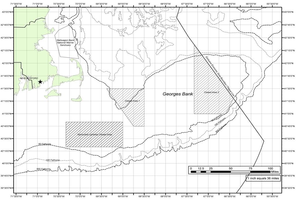
1 Lesson Title: Duration: 1-50 minute class period Overview: Students practice geography and math skills while learning about their relevancy to commercial fishing such as pinpointing locations, locating habitat protection areas (restricted access areas) calculating depth and distance using measurement conversions. Content Areas: Geography and Math Standards: Social Studies:G1 Use map and globe skills learned K-5 to interpret different kinds of map projections. G4 Explain the difference between absolute and relative location and give examples of different ways to indicate relative location for countries or cities across the world. G6 Distinguish between political and topographical maps and identify types of specialized maps Math: 5.M.3 Solve problems involving simple unit conversions within a system of measurement. 5 MD.1 Convert like measurement units within a given measurement system. 5 NBT.5 Perform operations with multi-digit whole numbers and with decimals to hundredths. Objectives: Students will be able to analyze a chart of the ocean (specifically Georges Bank), locate areas that the New Bedford fishing fleet utilizes (restricted and open areas), demonstrate basic pinpointing skills and make conversions within units of measurement (distance and depth) using map scale and contour lines. NBFHC Resources: Background Information Geo-Activity Georges Bank Map Materials: Pencil Ruler Calculator (optional) Activator: Ask these questions: Where does our local seafood come from? How far do you think this seafood has traveled before it gets to your plate? (Brainstorm on board together or in student journals) Activity: Read: Background information, then have students work on the accompanying Geo-Activity Questions using the map of Georges Bank provided. Summarizer: What have you learned about Georges Bank fishing? (Record answers on board or in journals) Assessment: Geo-Activity Extension Activity: Color the Georges Bank map using the contour lines as a guide. *Example: Color Massachusetts Green, Dark Blue to the 50 fathom line, Blue to 100 fathom line, light blue to the 500 fathom line, etc. The different shades of blue will accentuate the changes in ocean depth across George s Bank showing its bathymetry (the underwater equivalent of topography).

2 Name: Date: *Word Bank Crew- Several people who work together on a vessel. Dragger- A Fishing Boat that catches various groundfish species such as Cod Fish and Haddock.. Scalloper- A Fishing Boat that catches Sea Scallops. Steam- Nautical term that indicates time traveling to & from a destination. Vessel- A boat (Note: F/V is the abbreviation for fishing vessel) Georges Bank- Historically famous fishing ground east of New England. Have you ever wondered where fishing boats go to get the seafood that you enjoy? Before you take a bite out of that fish sandwich, or pop another fried scallop into your mouth, think about where they came from. Many *Scallopers and *Draggers from the port of New Bedford *steam for many hours and travel many miles out to sea before they even arrive at their fishing grounds, that means that they haven t even begun to catch anything yet. Many of our local fishermen fish on Georges Bank and are out to sea for as long as sixteen days, that s more than two weeks! When the fishing *vessel catches its limit, the *crew has to steam back to port to sell the fish or scallops which finally end up on your plate in a restaurant or at your home. plate Let s see how far your seafood has traveled to get from the deep ocean to your What You Will Need: Map, pencil, calculator (optional), and ruler (Use the map of Georges Bank to answer the following questions).
3 Name: Teacher Notes Date: Directions: Look at your map of Georges Bank. Notice the three closed areas that have been sectioned off; Nantucket Lightship Closed Area, Closed Area 1 and Closed Area 2. These are restricted access areas, Fishermen are only allowed to go into these areas for a certain number of days every year. Using your map, a pencil, ruler and scrap paper (or calculator) answer the following questions. 1. Please insert a compass rose onto your map. 2. What is the scale on this map? 1 inch = 36 miles 3. What are the coordinates (latitude and longitude) for the Port of New Bedford? 41º 38 N. 70º 56 W. 4. a. Pinpoint this location: 41º 30 N. 67º 0 W. Mark your location with an X. b. What is the name of this area? Closed Area 2 c. How many miles from New Bedford is your location (X)? 216 miles 5. There is a boundary line to the east of your location, what is it called? Exclusive Economic Zone Boundary or Hague Line 6. If a vessel steams 100 miles south from New Bedford, how deep is the water? Hint: (1 fathom= 6 ft) Fathoms? 100 Fathoms Feet? 600 Feet 7. If a vessel steams at 20 mph, how long would it take to get to this location? N. 68º0 W. 8.6 hours (172miles divided by 20) 8. What would the total steaming time be for this trip? (# hours x 2) 17.2 hours
4 Name: Date: Directions: Look at your map of Georges Bank. Notice the three closed areas that have been sectioned off; Nantucket Lightship Closed Area, Closed Area 1 and Closed Area 2, these are restricted access areas. Fishermen are only allowed to go into these areas for a certain number of days every year. Using your map, a pencil, ruler and scrap paper (or calculator) answer the following questions. 1. Please insert a compass rose on your map. 2. What is the scale on this map? 3. What are the coordinates (latitude and longitude) for the Port of New Bedford? 4. a. Pinpoint this location: 41º 30 N. 67º 0 W, mark your location with an X. b. What is the name of this area? c. How many miles from New Bedford is your location (X)? 5. Locate the boundary line to the East of your location, what is it called? 6. If a vessel steams 100 miles south from New Bedford, how deep is the water? (Hint: 1 fathom= 6 feet) Feet? Fathoms? 7. If a vessel steams at 20 mph, how long would it take to get to this location: N. 68º0 W? 8. What would the total steaming time be for this trip? (# hours x 2)
5
Lesson 2: Sailing. A league is three nautical miles. (A nautical mile is about 800 feet longer than a mile on land.)
") Early Explorers -> 2: Sailing Lesson 2: Sailing Getting Started? Big Ideas What methods did sailors have for survival on the seas? & Facts and Definitions 8 Skills " Materials Introduction Navigation is
Early Explorers -> 2: Sailing Lesson 2: Sailing Getting Started? Big Ideas What methods did sailors have for survival on the seas? & Facts and Definitions 8 Skills " Materials Introduction Navigation is
Nautical Navigation: Final Quiz
 Name: Nautical Navigation Final Quiz Class: (ver. 03/09/15) Date: Page 1 of 9 Nautical Navigation: Final Quiz There are three sections: Multiple Choice, True/False, and Short Answer. For the multiple choice,
1.0 Background. 2.0 Methods II-3
 Appendix II Summary of Scallop PDT Analyses used for Developing and Assessing the Potential Impacts of Alternatives Designed to Allow Limited Access Vessels Declare out of the Fishery on Return to Port
DRAFT VMS Corridor Analysis updated for November meetings
 DRAFT VMS Corridor Analysis updated for November meetings Alternatives Currently DAS are allocated to the limited access fishery based on an estimate of projected catch in open areas divided by an estimate
g) Use the map compass to provide the general locality of the knoll on the chart.
 Use the map compass to provide the general locality of the knoll on the chart.") The horizontal scale (x axis) of your cross-section/profile is the linear map distance between point A and point B on the map (or between X and Y and Z). It conforms to the map scale. In other words, the
The horizontal scale (x axis) of your cross-section/profile is the linear map distance between point A and point B on the map (or between X and Y and Z). It conforms to the map scale. In other words, the
Navigation & Orienteering: Pre- Test
 Name: Class: Answer Key Date: Page 1 of 7 Navigation & Orienteering: Pre- Test There are three sections: Multiple Choice, True/False, and Short Answer. For the multiple choice, please select the BEST answer
Habitat Omnibus Amendment DEIS draft sections relative to recreational fishery DRAFT. Omnibus Essential Fish Habitat Amendment 2
 DRAFT Omnibus Essential Fish Habitat Amendment 2 Amendment 14 to the Northeast Multispecies FMP Amendment 14 to the Atlantic Sea Scallop FMP Amendment 4 to the Monkfish FMP Amendment 3 to the Atlantic
Basic Chartwork. Necessary Tools. Navigation is the one science in which no margin whatever is left for the faker. - Felix Riesenberg
 Page 1 of 14 www.bananawind.us Navigation is the one science in which no margin whatever is left for the faker. - Felix Riesenberg Basic Chartwork You wouldn't want to attempt open ocean sailing using
Chartwork Learn the basics for position fixing using a number of techniques and a simple equation for speed, distance and time.
 Chartwork Learn the basics for position fixing using a number of techniques and a simple equation for speed, distance and time. Chartwork Chartwork Tools Accurate chart work is the basis for good navigation.
2011 Peabody Museum of Natural History, Yale University. All rights reserved.
 2011 Peabody Museum of Natural History, Yale University. All rights reserved. Operation Vector Find Rangers with the New Haven Parks Department have just discovered an old map. The map shows a remote
Chart Features Maritime maps and Admiralty charts have these features:
 Introduction to Charts A chart or map of the area is an important safety item to carry on board. It allows the Master to obtain knowledge of the area to be travelled, and indicates the navigable channels
Engineering Design Challenge. Mapping the Ocean Floor
 Engineering Design Challenge Project Title: Project Source: Project Submitter: Mapping the Ocean Floor NOAA, http://tinyurl.com/boydlek STEM Improvement Lesson Development Team Grade Level/Subject: Math,
Lesson 1: Decimal Place Value. Concept/Topic to Teach: Students use Bruins statistical data to order and compare decimals to the thousandths.
 Math Lesson 1: Decimal Place Value Concept/Topic to Teach: Students use Bruins statistical data to order and compare decimals to the thousandths. Standards Addressed: Standard 1: 5.NBT.3 Read, write, and
Multiplying Decimal Numbers
 LESSON 09 Multiplying Decimal Numbers Power Up facts mental math Power Up J a. Estimation: Choose the more reasonable estimate for the weight of a pencil: 8 grams or 8 kilograms. 8 grams b. Fractional
Your web browser (Safari 7) is out of date. For more security, comfort and. the best experience on this site: Update your browser Ignore
 is out of date. For more security, comfort and. the best experience on this site: Update your browser Ignore") Your web browser (Safari 7) is out of date. For more security, comfort and Activitydevelop the best experience on this site: Update your browser Ignore Fisheries and Seafood Consumption How do the locations
Your web browser (Safari 7) is out of date. For more security, comfort and Activitydevelop the best experience on this site: Update your browser Ignore Fisheries and Seafood Consumption How do the locations
Teaching students about how technology enables science through building Aquarius Habitats.
 Lesson Plan Aquarius Technology: Building an Underwater Habitat Focus Teaching students about how technology enables science through building Aquarius Habitats. Focus Questions Why build an underwater
Plot the Path into the Harbor
 Plot the Path into the Harbor By Mary Anne Otten, Rudyard Area Schools and Joan Chadde, Michigan Technological University Subject/Grade: Grade 3 6, Math, Social Studies, Science Duration: 35 minutes Lesson
Readiness: Scuba Diving
 Readiness: Scuba Diving AUTHOR INTENT Scuba diving is a real-world activity where each diver has to be responsible for their own safety. The safety of the divers relies on mathematics. The math reviewed
New England Fishery Management Council
 FOR IMMEDIATE RELEASE December 5, 2018 PRESS CONTACT: Janice Plante (607) 592-4817, jplante@nefmc.org Scallops: Council Takes Final Action on Framework 30; Sets Stage for Fishing Year 2019 with Defaults
How Fast Can You Throw?
 Name Date Period How Fast Can You Throw? Directions: Find a spot 40 feet from a wall and mark it with a piece of chalk. From that point, you will throw the ball 5 times with your right hand, and then five
F I N D I N G K A T A H D I N :
 F I N D I N G K A T A H D I N : An Online Exploration of Maine s Past LOBSTER ROLL!* Lesson 7.3 Objective: Students will collect data by playing a game that illustrates the delicate ecological balance
SUSTAINABLE SEAFOOD MATCHING
 RAINY DAY KITS FOR ENVIRONMENTAL EDUCATION This Lesson Created in Partnership with: SUSTAINABLE SEAFOOD MATCHING Overview Students play a matching game to learn about different fish species and whether
National Maritime Center
 National Maritime Center Providing Credentials to Mariners Q163 Navigation Problems-Chart 13205 TR (Sample Examination) Page 1 of 5 Choose the best answer to the following Multiple Choice Questions. Each
Plot the Path. Mary Anne Otten. lesson three
 Plot the Path Mary Anne Otten lesson three Subject/Grade: Grade 2, Math, Social Studies, Science Duration: one class period Materials needed: Per class: Day the Great Lakes Drained Away by Charles Ferguson
Introduction to Measurement Developing Standard and Metric Measuring Skills
 Introduction to Measurement Developing Standard and Metric Measuring Skills Design and Modeling 2011 Project Lead The Way, Inc. Why Learn to Measure? Valuable skill for a job Valuable skill for hobbies
Unit 8: Home Practice
 Unit 8: Home Practice Part Triangle Flash Cards: All the Facts Study for the quiz on the multiplication and division facts. Take home your Triangle Flash Cards and your list of facts you need to study.
The Bruins I.C.E. School
 The Bruins I.C.E. School Lesson 1: Decimal Place Value Lesson 2: Measurement and Data Lesson 3: Coordinate Graphing Lesson 4: Adding and Subtracting Fractions Lesson 5: Order of Operations Worksheets Included:
Hooray for Barnegat Bay!
 Hooray for Barnegat Bay! Subject Areas: Science, Social Studies Setting: Classroom Duration: One class period Skills: critical thinking, discussing, listing, comparing, listening, interviewing Vocabulary:
Applying Rational Number Operations
 ? LESSON 3.6 Applying Rational Number Operations ESSENTIAL QUESTION 7.EE.3 Solve problems with positive and negative rational numbers in any form using tools strategically. (For the full text of the standard,
Fisheries of the Caribbean, Gulf of Mexico, and South Atlantic; Reef Fish Fishery of Puerto Rico and the U.S. Virgin Islands;
 This document is scheduled to be published in the Federal Register on 06/11/2018 and available online at https://federalregister.gov/d/2018-12420, and on FDsys.gov BILLING CODE: 3510-22-P DEPARTMENT OF
Lat. & Long. Review. Angular distance N or S of equator Equator = 0º Must indicate N or S North pole = 90º N
 Navigation Part 2 1 Lesson Objectives Understand how a ships compass works and how it is used for navigation Measure distances on nautical charts Plot a course on a nautical chart Correct course headings
DRAFT Do not reference or circulate
 Excerpt from OHA2 FEIS Council preferred alternatives (underlined) The Council identified preferred alternatives for most sections of OHA2 at its meeting in Mystic, CT on April 21-23, 2015. At that meeting,
Atlantic Sea Scallop Fishery. Fleet Dynamics of the. Paul Rago and Dvora Hart. Northeast Fisheries Science Center. National Marine Fisheries Service
 Fleet Dynamics of the Atlantic Sea Scallop Fishery Paul Rago and Dvora Hart National Marine Fisheries Service Northeast Fisheries Science Center Woods Hole, MA 02543 Objectives of Presentation Describe
Sustainable Fisheries for Future Generations The Fisheries White Paper
 Sustainable Fisheries for Future Generations The Fisheries White Paper Key messages The Fisheries White Paper Sustainable Fisheries for Future Generations charts the course for a sustainable and profitable
Novel Ties. The Wanderer. A Study Guide Written By Estelle Kleinman Edited by Joyce Friedland and Rikki Kessler
 Novel Ties The Wanderer Sharon Creech A Study Guide Written By Estelle Kleinman Edited by Joyce Friedland and Rikki Kessler LEARNING LINKS P.O. Box 326 Cranbury New Jersey 08512 TABLE OF CONTENTS Synopsis.....................................
Fisheries off West Coast States; Pacific Coast Groundfish Fishery Management Plan;
 This document is scheduled to be published in the Federal Register on 03/29/2018 and available online at https://federalregister.gov/d/2018-06316, and on FDsys.gov Billing Code 3510-22-P DEPARTMENT OF
Anchoring Is Important
 BCC Sailing Classes - Third Theory Anchoring Anchoring Is Important 1 The Anchor is your last resort. Anchoring Keep off a lee shore. Needs to be shaped (type of anchor) to bury in the type of bottom for
In this lesson, students determine the speed of a tsunami using tsunami time travel maps and Google Earth.
 Speedy Tsunami Overview: In this lesson, students determine the speed of a tsunami using tsunami time travel maps and Google Earth. Targeted Alaska Grade Level Expectations: Science [] SA1.1 The student
New England Fishery Management Council
 FOR IMMEDIATE RELEASE December 7, 2017 PRESS CONTACT: Janice Plante (607) 592-4817, jplante@nefmc.org Scallops: Council Approves Framework 29 with 2018-2019 Specs Under Four Potential Habitat Amendment
AIR NAVIGATION. Key Revision. Press F5 to start.
 AIR NAVIGATION Key Revision Press F5 to start. This presentation may be used either as a revision aid or as a self-test program. Revision Self-test Instructions This presentation may be used either as
Snapshot Day Lesson Plan Math with Ships
 Snapshot Day Lesson Plan Math with Ships Summary: Students will use mathematical reasoning to determine elapsed times, distances covered, and the speeds of boats sailing the Hudson River on Snapshot Day
ASSESSMENT OF SCALLOPS (PLACOPECTEN MAGELLANICUS) IN SCALLOP FISHING AREA (SFA) 29 WEST OF LONGITUDE 65 30'W
 IN SCALLOP FISHING AREA (SFA) 29 WEST OF LONGITUDE 65 30'W") Canadian Science Advisory Secretariat Science Advisory Report 2013/055 ASSESSMENT OF SCALLOPS (PLACOPECTEN MAGELLANICUS) IN SCALLOP FISHING AREA (SFA) 29 WEST OF LONGITUDE 65 30'W Figure 1. Location of
Canadian Science Advisory Secretariat Science Advisory Report 2013/055 ASSESSMENT OF SCALLOPS (PLACOPECTEN MAGELLANICUS) IN SCALLOP FISHING AREA (SFA) 29 WEST OF LONGITUDE 65 30'W Figure 1. Location of
MVSU NCLB 2016 Summer Reading Institute Lesson Plan Template. Name Angela Roberson
 Name Angela Roberson Name of Unit The Greatest Game Ever Played Day 1 Grade Level 6 th Understand that a set of data collected to answer a statistical question has a distribution which can be described
AUS small scale charts for coastal navigation. Scale: 1 to 150,000
 CHART-WORK SCALE Charts are available in different scales depending on their use. For passage planning you would use small scale charts and for close quarter manoeuvring you would use larger scale charts
Explorers Education Programme. Subject Mathematics
 Strand Data Date Class level Sixth Class Strand Unit Representing and Interpreting Data Title Interpreting Data about Prawns landed in Irish waters. Subject Mathematics Objective(s) The aim of the lesson
Proactive approaches and reactive regulations: Accounting for bycatch in the US sea scallop fishery
 Proactive approaches and reactive regulations: Accounting for bycatch in the US sea scallop fishery Catherine E. O Keefe and Steven X. Cadrin University of Massachusetts Dartmouth School for Marine Science
Effective Collaboration Between Scientists, Managers and Policy Makers
 2009/FWG/WKSP/007 Effective Collaboration Between Scientists, Managers and Policy Makers Submitted by: World Bank Workshop on Implementing Ecosystem Approaches to Fisheries in the Context of the Broader
Module 2, Add on Lesson Depth Sensor. Teacher. 90 minutes
 Module 2, Add on Lesson Depth Sensor 90 minutes Teacher Purpose of this lesson Investigate the relationship between pressure and depth Construct a sensor to measure the depth of water Graph data and reason
Current Position in Thailand What CP is doing to tackle ethical issues in the Thai seafood supply chain
 Current Position in Thailand What CP is doing to tackle ethical issues in the Thai seafood supply chain Progress update for Seafood Ethics Common Language Group Wednesday 14 th January 2015 CP Foods UK
6.RP Speed Conversions
 6.RP Speed Conversions Alignments to Content Standards: 6.RP.A.3.d Task Jessica sees the following speed limit sign while visiting Australia where the units for speed are kilometers per hour: a. A conversion
Socioeconomic Impacts of Crab Rationalization on the Aleutian East Borough Communities of False Pass, Akutan, and King Cove
 Socioeconomic Impacts of Crab Rationalization on the Aleutian East Borough Communities of False Pass, Akutan, and King Cove Dr. Marie Lowe Dr. Gunnar Knapp Assistant Professor of Anthropology Professor
LEARNING OBJECTIVES. Overview of Lesson. guided practice Teacher: anticipates, monitors, selects, sequences, and connects student work
 D Rate, Lesson 1, Conversions (r. 2018) RATE Conversions Common Core Standard N.Q.A.1 Use units as a way to understand problems and to guide the solution of multi-step problems; choose and interpret units
Activities of KHOA on creation of S-10X test data sets and S-100 sea trial
 Activities of KHOA on creation of S-10X test data sets and S-100 sea trial Submitted by: Executive Summary: Related Documents: Related Projects: Republic Of Korea (KHOA) KHOA has been conducting a research
Summer Visitors Play in Martha's Vineyard and Nantucket
 Summer Visitors Play in Martha's Vineyard and Nantucket Welcome to This Is America with VOA Learning English. This week on our program, we tell you about two islands in Massachusetts, in the New England
Activity Standard and Metric Measuring
 Activity 1.3.2 Standard and Metric Measuring Introduction Measurements are seen and used every day. You have probably worked with measurements at home and at school. Measurements can be seen in the form
Utilizing Vessel Based Mobile LiDAR & Bathymetry Survey Techniques for Survey of Four Southern California Breakwaters
 Utilizing Vessel Based Mobile LiDAR & Bathymetry Survey Techniques for Survey of Four Southern California Breakwaters Western Dredging Association: Pacific Chapter September 2012 Insert: Pipe Location
New England Fishery Management Council MEMORANDUM
 New England Fishery Management Council 50 WATER STREET NEWBURYPORT, MASSACHUSETTS 01950 PHONE 978 465 0492 FAX 978 465 3116 John Pappalardo, Chairman Paul J. Howard, Executive Director MEMORANDUM DATE:
Place Value
 Place Value Finding the of a decimal: Step 1: Find the in the decimal. The is what separates the whole numbers from the decimal numbers. The whole numbers are the digits to the left of the. The decimal
CA Collaborative Fisheries Research Program. Rod-and-Reel Surveys of Nearshore Fishes in and Near Central California Marine Protected Areas
 CA Collaborative Fisheries Research Program Rod-and-Reel Surveys of Nearshore Fishes in and Near Central California Marine Protected Areas Methodology Overview For information that is more detailed see
March Madness Basketball Tournament
 March Madness Basketball Tournament Math Project COMMON Core Aligned Decimals, Fractions, Percents, Probability, Rates, Algebra, Word Problems, and more! To Use: -Print out all the worksheets. -Introduce
Harbor Porpoise Take Reduction Plan: New England
 Harbor Porpoise Take Reduction Plan: New England Photo Ann-Louise Jensen / Fjord & Bælt Centre NOAA Fisheries Service U.S. Department of Commerce National Oceanic and Atmospheric Administration National
Pacific Charter Institute Pacing Guide Grade(s): _5 Subject Area: _Math in Focus grade 5 CP: yes _X no
: _5 Subject Area: _Math in Focus grade 5 CP: yes _X no") Week 1 Pre-requisite skills review Chapter 1 pre-test Assessment 5 chapter pre-test pp. 1-4 or MIF Student book 5A pp. 1-4 Reteach 4A (1.1, 1.2, 2.1, 3.2, 3.4) NWEA Kids start Wed. Week 2 1.1 Writing numbers
Week 1 Pre-requisite skills review Chapter 1 pre-test Assessment 5 chapter pre-test pp. 1-4 or MIF Student book 5A pp. 1-4 Reteach 4A (1.1, 1.2, 2.1, 3.2, 3.4) NWEA Kids start Wed. Week 2 1.1 Writing numbers
Modelling historical distribution of. trawling effort. British steam trawlers in the North Sea
 Modelling historical distribution of trawling effort British steam trawlers in the North Sea Motivation Why study fleet dynamics? North Sea: dramatic changes fish abundance For understanding, not enough
Fresh, All Natural& Sustainable. January 2015
 Fresh, All Natural& Sustainable January 2015 Sourcing Sustainable Seafood Family Owned and Focused for Four Generations 2 Perishability Why is fish so much more perishable than meat? Harvesting - most
Fine-scale Focal DTAG Behavioral Study in the Gulf of Maine
 DISTRIBUTION STATEMENT A: Approved for public release; distribution is unlimited. Fine-scale Focal DTAG Behavioral Study in the Gulf of Maine Alessandro Bocconcelli Woods Hole Oceanographic Institution
Socioeconomic Profile and Spatial Analysis of Fisheries in the three central California National Marine Sanctuaries
 Socioeconomic Profile and Spatial Analysis of Fisheries in the three central California National Marine Sanctuaries Overview and Assessment of CDFG Fisheries Data for use in the Joint Management Plan Review
Circumnavigation of the Globe
 Title: Circumnavigation of the Globe (Historical Perspectives) Grade Level(s): 6-8 Introduction: Throughout history, there have been many navigators, sailors, seamen, explorers, and merchants that have
17. High Resolution Application of the Technology Development Index (TDI) in State Waters. South of Block Island
 in State Waters. South of Block Island") 17. High Resolution Application of the Technology Development Index (TDI) in State Waters South of Block Island for the Rhode Island Ocean Special Area Management Plan 2010 by Annette Grilli 1, Malcolm
17. High Resolution Application of the Technology Development Index (TDI) in State Waters South of Block Island for the Rhode Island Ocean Special Area Management Plan 2010 by Annette Grilli 1, Malcolm
N2-3 Rounding and Approximation
 N2-3 Rounding and Approximation rounding of numbers approximate calculations Pre-requisites: N2-2 (Decimal Operations 1) Estimated Time: 3 hours Summary Lead In Learn Solve Revise Answers Summary We can
Your web browser (Safari 7) is out of date. For more security, comfort and the best experience on this site: Update your browser Ignore
 is out of date. For more security, comfort and the best experience on this site: Update your browser Ignore") Your web browser (Safari 7) is out of date. For more security, comfort and the best experience on this site: Update your browser Ignore Activityapply ADAPTING U NDER PRESSU RE What do an organism s physical
Your web browser (Safari 7) is out of date. For more security, comfort and the best experience on this site: Update your browser Ignore Activityapply ADAPTING U NDER PRESSU RE What do an organism s physical
COMMENT RESPONSE MATRIX Revised Micro-siting Plan for the OOI Pioneer Array PUBLIC COMMENT PERIOD: April 12 May 27, 2011
 COMMENT RESPONSE MATRIX Revised Micro-siting Plan for the OOI Pioneer Array PUBLIC COMMENT PERIOD: April 12 May 27, 2011 William J. Mulvey F/V Stormy Elizabeth Port of Galilee Point Judith, RI 20 May I
Larger Units. Smaller Units
 UNITS OF LENGTH: CUSTOMARY & METRIC (4 TH GRADE) TEACHER GUIDE Objective: The student will be able to use their knowledge of the standardized mathematics exam chart and their multiplication/division skills
Massachusetts on Offshore Wind and Fishing
 New England Fisheries Management Council: Massachusetts on Offshore Wind and Fishing October 4, 2017 Bill White Senior Director, Offshore Wind Sector Development Terminal Director, New Bedford Marine Commerce
HOW TO BEST USE YOUR ELECTRONICS: CHARTING, SONAR, AND IMAGING. By: Captain Tom Blackburn
 HOW TO BEST USE YOUR ELECTRONICS: CHARTING, SONAR, AND IMAGING By: Captain Tom Blackburn Topics I. INTRODUCTION II. CHARTING A TREMENDOUS FISH FINDING TOOL III. CHARTING - SIGNIFICANT CHARTING AND NAVIGATIONAL
AP Physics 1 Summer Assignment 2014
 AP Physics 1 Summer Assignment 2014 Begin this packet after you confirm your placement with guidance. This assignment is being handed out to all students who have requested AP Physics 1 in 2014-15. Receiving
National Standard 10 Advanced Notice of Proposed Rulemaking New England Fishery Management Council
 National Standard 10 Advanced Notice of Proposed Rulemaking New England Fishery Management Council Portland, ME June 21, 2011 Presentation Outline Information on Fishing Safety National Standard 10 and
2017 CONSERVATION HARVESTING PLAN Atlantic Halibut (4RST) Prince Edward Island fixed gear fleet Less than meters
 Prince Edward Island fixed gear fleet Less than meters") Approved on July 13, 2017 APPLICATION This Conservation Harvesting Plan (CHP) applies to all Prince Edward Island (PEI) fixed gear licence holders fishing Atlantic halibut in NAFO Divisions 4RST with vessels
Approved on July 13, 2017 APPLICATION This Conservation Harvesting Plan (CHP) applies to all Prince Edward Island (PEI) fixed gear licence holders fishing Atlantic halibut in NAFO Divisions 4RST with vessels
Pace and Compass. Teacher Instructions. Overview: Objectives: Materials:
 Teacher Instructions and Overview: Scientists use maps to record and monitor many geologic features, including lava flows, calderas, and volcano vents. The boundaries of these features can be mapped with
Bathymetry Data Collection for Subaqueous Soil Mapping. Maggie Payne 2 nd National Workshop on Subaqueous Soils Rhode Island August 9-12, 2010
 Bathymetry Data Collection for Subaqueous Soil Mapping Maggie Payne 2 nd National Workshop on Subaqueous Soils Rhode Island August 9-12, 2010 Overview of Method Collect tide data Collect bathymetry data
5th Grade Decimal Concepts
 Slide 1 / 192 Slide 2 / 192 5th Grade Decimal Concepts 2015-11-16 www.njctl.org Slide 3 / 192 Table of Contents What is a Decimal? Click on a topic to go to that section. Identify Place Values Read and
5th Grade. Slide 1 / 192. Slide 2 / 192. Slide 3 / 192. Decimal Concepts. Table of Contents
 Slide 1 / 192 Slide 2 / 192 5th Grade Decimal Concepts 2015-11-16 www.njctl.org Table of Contents Slide 3 / 192 What is a Decimal? Click on a topic to go to that section. Identify Place Values Read and
March Madness Basketball Tournament
 March Madness Basketball Tournament Math Project COMMON Core Aligned Decimals, Fractions, Percents, Probability, Rates, Algebra, Word Problems, and more! To Use: -Print out all the worksheets. -Introduce
Gulf of Maine Research Institute Responsibly Harvested Seafood from the Gulf of Maine Region Report on Atlantic Sea Scallops (Inshore Canada)
") Gulf of Maine Research Institute Responsibly Harvested Seafood from the Gulf of Maine Region Report on Atlantic Sea Scallops (Inshore Canada) The fishery is managed by a competent authority and has a management
Gulf of Maine Research Institute Responsibly Harvested Seafood from the Gulf of Maine Region Report on Atlantic Sea Scallops (Inshore Canada) The fishery is managed by a competent authority and has a management
Biological Review of the 2014 Texas Closure
 Biological Review of the 2014 Texas Closure Report to the Gulf of Mexico Fishery Management Council by James M. Nance, Ph.D. Southeast Fisheries Science Center Galveston Laboratory January 2015 Introduction
FRA SUMMER MATH 2017 Math Course 3
 FRA SUMMER MATH 2017 Math Course 3 The following can be found within this file on the specific pages listed: Content Math Course 3 Teacher Letter and Summer Math Directions Pages 2 Math Course 3 Overview
Evolution of Deepwater Coral Protection in the Southeast U.S
 Evolution of Deepwater Coral Protection in the Southeast U.S Tina Udouj, Florida Fish and Wildlife Conservation Commission Roger Pugliese, South Atlantic Fishery Management Council Overview Deepwater Corals
The Socio-Economic Marine Research Unit (SEMRU) Research Note. Assessment of the effects of Brexit on Irish and EU fisheries in the NE Atlantic
 Research Note. Assessment of the effects of Brexit on Irish and EU fisheries in the NE Atlantic") The Socio-Economic Marine Research Unit (SEMRU) National University of Ireland, Galway Research Note Assessment of the effects of Brexit on and EU fisheries in the NE Atlantic Daniel Norton and Stephen
The Socio-Economic Marine Research Unit (SEMRU) National University of Ireland, Galway Research Note Assessment of the effects of Brexit on and EU fisheries in the NE Atlantic Daniel Norton and Stephen
A school trip. An evening of your favourite television programmes. A rehearsal plan. To cook a two course meal.
 Experience & Outcome: MNU 2-10a use and interpret electronic and paper-based timetables and schedules to plan events and activities, and make time calculations as part of my planning. recognise types of
Homework 2 Bathymetric Charts [based on the Chauffe & Jefferies (2007)]
![Homework 2 Bathymetric Charts [based on the Chauffe & Jefferies (2007)]](/thumbs/75/72427079.jpg "Homework 2 Bathymetric Charts [based on the Chauffe & Jefferies (2007)]") 1 MAR 110 HW-2 - Bathy Charts Homework 2 Bathymetric Charts [based on the Chauffe & Jefferies (2007)] 2-1. BATHYMETRIC CHARTS Bathymetric charts are maps of a region of the ocean used primarily for navigation
1 MAR 110 HW-2 - Bathy Charts Homework 2 Bathymetric Charts [based on the Chauffe & Jefferies (2007)] 2-1. BATHYMETRIC CHARTS Bathymetric charts are maps of a region of the ocean used primarily for navigation
Rethinking the Three Hour Daysail
 Rethinking the Three Hour Daysail American Sail Training Association's 37th Annual Conference on Sail Training and Tall Ships Margaret Flanagan Director of Marine Education Schooner Pioneer 1885 Marcus
Massachusetts Lobstermen s Association 3/14/2018. March
 Massachusetts Lobstermen s Association 3/14/2018 March 2018 1 Where are we in the process? Public input opportunities (purple) December 2017 Federal Permitting Draft COP submitted Ongoing updates to COP
Lesson one. Linear Motion. Terminal Objective. Lesson 1. Linear Motion
 Lesson one Terminal Objective Using their class notes to complete the handout on linear motion, students will be able to demonstrate their understanding of speed and acceleration by problem solving different
Of the Salmon and For the Salmon
 Of the Salmon and For the Salmon for millions of years the wild salmon has helped nourish the plant and animal life of the temperate rain forest. Born in the streams and rivers of the forest, the salmon
TEAMING WITH INSECTS ENTOMOLOGY LEVEL 1 GRADES 3-5
 TEAMING WITH INSECTS ENTOMOLOGY LEVEL 1 GRADES 3-5 The Teaming with Insects curriculum is written for youth who enjoy learning about science and nature. The 4-H Entomology project offers many educational
BASELINE SURVEY, VISUAL - SITE SPECIFIC
 BASELINE SURVEY, VISUAL - SITE SPECIFIC Introduction As stated in SEPA s policy and in the Fish Farm Manual (1998), scientific data are required by SEPA in order to assess the existing condition on the
Test 1: Ocean 116 (Oceanography Lab.)
") GLENDALE COMMUNITY COLLEGE Name Marks secured /25 Test 1: Ocean 116 (Oceanography Lab.) Dr. Poorna Pal Note: Answer all questions/solve all problems, giving detailed answers, as may be needed. Show all
GLENDALE COMMUNITY COLLEGE Name Marks secured /25 Test 1: Ocean 116 (Oceanography Lab.) Dr. Poorna Pal Note: Answer all questions/solve all problems, giving detailed answers, as may be needed. Show all
National Maritime Center
 National Maritime Center Providing Credentials to Mariners (Sample Examination) Page 1 of 5 Choose the best answer to the following Multiple Choice Questions. 1. The following questions are based on Chart
Converting Between Measurement Systems. ESSENTIAL QUESTION How can you use ratios and proportions to convert measurements? 7.4.E
 LESSON 3.1 Converting Between Measurement Systems Proportionality 7.4.E Convert between measurement systems, including the use of proportions and the use of unit rates. Also 7.4.D? ESSENTIAL QUESTION How
Lesson 22: Getting the Job Done Speed, Work, and Measurement Units
 Lesson 22: Getting the Job Done Speed, Work, and Measurement Units Student Outcomes Students decontextualize a given speed situation, representing symbolically the quantities involved with the formula.
2017 PACIFIC HALIBUT CATCH SHARING PLAN FOR AREA 2A
 (a) FRAMEWORK 2017 PACIFIC HALIBUT CATCH SHARING PLAN FOR AREA 2A This Plan constitutes a framework that shall be applied to the annual Area 2A total allowable catch (TAC) approved by the International