SOCCOM.Act.PDS.1.1: Tracking Ocean Currents
|
|
|
- Stanley Lloyd
- 6 years ago
- Views:
Transcription


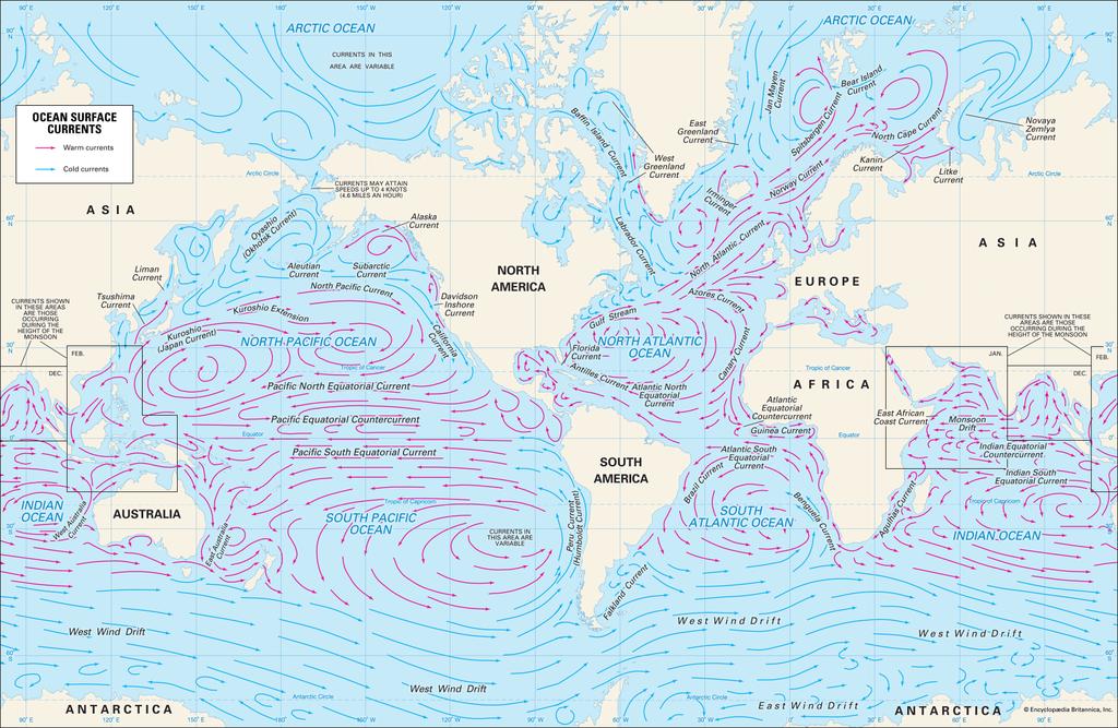
1 SOCCOM.Act.PDS.1.1 Tracking Ocean Currents SOCCOM.Act.PDS.1.1: Tracking Ocean Currents Goals In this activity you will: Use SOCCOM float data to learn about ocean currents. Learn about circulation in the Great Southern Ocean. Find where Huey, Dewey, and Louie are. Investigate the nature of ocean gyres. What To Turn In This first page, as a cover sheet Your written answers, properly formatted A filled-in copy of the Reported Locations For Several Floats In The Southern Ocean table A neatly made Calculated Drift Rates For Several Floats In The Southern Ocean table A neatly marked map of the world showing where selected Floats are located
2 SOCCOM.Act.PDS.1.1 Tracking Ocean Currents Visit the home page for the SOCCOM project, which is at Click on the Observations drop-down menu, and choose Map Room. This will take you to the SOCCOM Map Room. In the Map Room, click on the link for the Oceanographic Autonomous Observations Map (the link is embedded in the line SOCCOM float tracking and data profiles ). ( This interactive OAO map will allow you to track not just the SOCCOM floats, but the floats of several other projects as well. If you can t find a float on the OAO Map, it might be because it s not part of the SOCCOM group. Make sure you have changed the Project setting to show all floats. Part A: Currents And The Southern Ocean 1. Obtain from your teacher a copy of the blank table entitled Reported Locations For Several Floats In The Southern Ocean. Fill it in, using the interactive OAO Map listed above. Report your latitudes and longitudes to the nearest tenth of a degree. This web site may help you to calculate the distances between map locations ( This web site may help you to calculate the number of days between two given dates ( 2. Using the data from the table you filled in for question #1, create a brand new, separate table. It should be set up like this:
3 SOCCOM.Act.PDS.1.1 Tracking Ocean Currents Part B: Huey, Dewey, & Louie Continue to use the interactive OAO map listed above to answer the following questions about three SOCCOM floats. 3. Float 9668 on the map. This is Huey. To the nearest tenth of a degree, what is its most recent position? Where in the world is this? 4. Describe Huey s motion. What current(s) might be involved? 5. Find Float 9646 on the map. This is Dewey. To the nearest tenth of a degree, what is its most recent position? Where in the world is this? 6. Describe Dewey s motion. What current(s) might be involved? Discuss surface currents and deep currents (including the ACC). 7. Find Float 9666 on the map. This is Louie. To the nearest tenth of a degree, what is its most recent position? Where in the world is this? 8. Describe Louie s motion. What current(s) might be involved? Discuss surface currents and deep currents (including the ACC). 9. Given the deployment dates for Floats 9668 (Huey), 9646 (Dewey), & 9666 (Louie), what conclusions can you reach about their motion? 10. (TRQ) Why do you think Floats 9646 (Dewey) and 9666 (Louie) were deployed so close together? Do you think this was a good idea? If so, were other SOCCOM floats deployed closely? If you don t think this was a good idea, then why not? Either way, be sure to support your reasoning with evidence. Part C: Going Nowhere Fast Continue to use the interactive OAO map listed above to answer the following questions about three non-soccom floats. 11. Find Float B07_ on the map. To the nearest tenth of a degree, what is its most recent position? Where in the world is this? 12. Find Float CALYPSO on the map. To the nearest tenth of a degree, what is its most recent position? Where in the world is this? 13. Find Float CSIRO_ on the map. To the nearest tenth of a degree, what is its most recent position? Where in the world is this? 14. (TRQ) What do the locations of Floats B07_ , CALYPSO, and CSIRO_ have in common? Do their movement patterns support your inference? Also, are there other nearby floats that support your inference?
4 SOCCOM.Act.PDS.1.1 Tracking Ocean Currents Part D: Where Are All These Floats, Anyway? 15. Obtain from your teacher a copy of a blank map of the world. Plot the most recent locations of the following floats, by writing the number of the float in the correct location on the map (remember to keep your map neat and legible!). Attach a key to your map. The key should look like this: Number On Map Float Name _ ("Huey") ("Dewey") ("Louie") 13 B07_ CALYPSO 15 CSIRO_ Why is a Mercator projection map difficult to use when studying the Southern Ocean? 17. The arrows in the map are schematic only. Discuss the difficulties of knowing how currents at different depths actually behave in reality. 18. Discuss how floats enable scientists to understand deeper current behavior.
5 Reported Locations For Several Floats In The Southern Ocean Float Name SOCCOM? Which part of the Southern Ocean Deployment Date Last Reported Date Deployment Latitude Deployment Longitude Last Reported Latitude Last Reported Longitude 7552 Australia Australia Pacific Ocean 9092 Pacific Ocean 9031 Pacific Ocean _ Atlantic Ocean Near Atlantic Ocean Near
6
Ocean Currents Lecture Notes
 Ocean Currents Lecture Notes (Topic 9A) page 1 Ocean Currents Lecture Notes Surface Currents Ocean Currents (What is an ocean current? How is a current different from a wave?) The water in an travels from
Section 6. The Surface Circulation of the Ocean. What Do You See? Think About It. Investigate. Learning Outcomes
 Chapter 5 Winds, Oceans, Weather, and Climate Section 6 The Surface Circulation of the Ocean What Do You See? Learning Outcomes In this section, you will Understand the general paths of surface ocean currents.
General Oceanography Geology 105 Expedition #19 The Ocean and Climate
 General Oceanography Geology 105 Expedition #19 The Ocean and Climate Name Not attempting to answer questions on expeditions will result in point deductions on course workbook (two or more blank answers
Ocean Currents Unit (4 pts)
") Name: Section: Ocean Currents Unit (Topic 9A-1) page 1 Ocean Currents Unit (4 pts) Ocean Currents An ocean current is like a river in the ocean: water is flowing traveling from place to place. Historically,
Name: Section: Ocean Currents Unit (Topic 9A-1) page 1 Ocean Currents Unit (4 pts) Ocean Currents An ocean current is like a river in the ocean: water is flowing traveling from place to place. Historically,
The Causes of Ocean Circulation
 Activity 1 The Causes of Ocean Circulation Goals In this activity you will: Understand the effect of the wind on the movement of water at the ocean surface. Understand the effect of the Coriolis force
NOTE ->->-> DUE THURSDAY APRIL 20 TH 2006 THAT IS CORRECT I FORGOT THIS IS EASTER WEEKEND SO I HAVE EXTENDED THE DUE DATE TO THE ABOVE
 GEO 130 NAME OCEANOGRAPHY TEST 3 TAKE HOME TEST SPRING 2006 NOTE ->->-> DUE THURSDAY APRIL 20 TH 2006 THAT IS CORRECT I FORGOT THIS IS EASTER WEEKEND SO I HAVE EXTENDED THE DUE DATE TO THE ABOVE This test
Role of the oceans in the climate system
 Role of the oceans in the climate system heat exchange and transport hydrological cycle and air-sea exchange of moisture wind, currents, and upwelling gas exchange and carbon cycle Heat transport Two Primary
and the Link between Oceans, Atmosphere, and Weather
 Geography Worksheet Instructions Using a map, atlas, or any other materials your teacher suggests, label the following on the blank map provided. 1. Label East, West, North, and South. 2. Label the following
Test 1: Ocean 116 (Oceanography Lab.)
") GLENDALE COMMUNITY COLLEGE Name Marks secured /25 Test 1: Ocean 116 (Oceanography Lab.) Dr. Poorna Pal Note: Answer all questions/solve all problems, giving detailed answers, as may be needed. Show all
GLENDALE COMMUNITY COLLEGE Name Marks secured /25 Test 1: Ocean 116 (Oceanography Lab.) Dr. Poorna Pal Note: Answer all questions/solve all problems, giving detailed answers, as may be needed. Show all
Chapter 22, Section 1 - Ocean Currents. Section Objectives
 Chapter 22, Section 1 - Ocean Currents Section Objectives Intro Surface Currents Factors Affecting Ocean Currents Global Wind Belts (you should draw and label a diagram of the global wind belts) The Coriolis
Currents & Gyres Notes
 Currents & Gyres Notes Current A river of water flowing in the ocean. 2 Types of Currents Surface Currents wind-driven currents that occur in the top 100m or less Deep Currents density-driven currents
WEBB RESEARCH CORPORATION
 Use spacebar or arrow keys to advance slide show WEBB RESEARCH CORPORATION Falmouth, MA APEX Profiler SLOCUM Glider Rev: 06/22/08 WEBB RESEARCH CORPORATION Specialists in neutrally buoyant drifters and
Level 3 Earth and Space Science, 2018
 91413 914130 3SUPERVISOR S Level 3 Earth and Space Science, 2018 91413 Demonstrate understanding of processes in the ocean system 2.00 p.m. Thursday 22 November 2018 Credits: Four Achievement Achievement
Lesson: Ocean Circulation
 Lesson: Ocean Circulation By Keith Meldahl Corresponding to Chapter 9: Ocean Circulation As this figure shows, there is a connection between the prevailing easterly and westerly winds (discussed in Chapter
Argo National Data Management Report Italy (2016)
") Argo National Data Management Report Italy (2016) 1. Status Data acquired from floats: 335 floats were deployed in the Mediterranean and in Black Seas between 2001 and 2016 (the floats temporal distribution
Argo National Data Management Report Italy (2016) 1. Status Data acquired from floats: 335 floats were deployed in the Mediterranean and in Black Seas between 2001 and 2016 (the floats temporal distribution
Lecture 5.1 Surface Ocean Circulation. Image from Daily Mail Newspaper, UK
 Lecture 5.1 Surface Ocean Circulation Image from Daily Mail Newspaper, UK Announcements Midterm is Thursday, consists of 25 multiple choice, 3 pages short answer questions No Scantron needed Calculators,
SIO 210 Problem Set 3 November 4, 2011 Due Nov. 14, 2011
 SIO 210 Problem Set 3 November 4, 2011 Due Nov. 14, 2011 1. At 20 N, both the ocean and the atmosphere carry approximately 2 PW of heat poleward, for a total of about 4 PW (see figure). If (at this latitude)
SURFACE CURRENTS AND TIDES
 NAME SURFACE CURRENTS AND TIDES I. Origin of surface currents Surface currents arise due to the interaction of the prevailing wis a the ocean surface. Hence the surface wi pattern (Figure 1) plays a key
Directed Reading. Section: Ocean Currents. a(n). FACTORS THAT AFFECT SURFACE CURRENTS
. FACTORS THAT AFFECT SURFACE CURRENTS") Skills Worksheet Directed Reading Section: Ocean Currents 1. A horizontal movement of water in a well-defined pattern is called a(n). 2. What are two ways that oceanographers identify ocean currents? 3.
Skills Worksheet Directed Reading Section: Ocean Currents 1. A horizontal movement of water in a well-defined pattern is called a(n). 2. What are two ways that oceanographers identify ocean currents? 3.
For Class Today How does ocean water circulate? Ocean currents, surface currents, gyres, currents & climate, upwelling, deep ocean circulation
 For Class Today Modified Cornell Notes on section 16.1 (pg. 448-453) **Follow the guide in your ISN and previous notes for help** Heading: How does ocean water circulate? Left hand side categories: Ocean
Seawater. Earth is an Ocean Planet
 Seawater Earth is an Ocean Planet Topics Origin of the Ocean and Atmosphere Hydrologic Cycle Biogeochemical Cycle Seawater Salinity Variations in Seawater Chemistry Carbonic Acid System Topics Origin of
CRUISE REPORT FOR UW BERING STRAIT MOORING PROJECT 2005 Rebecca Woodgate, University of
 CRUISE REPORT FOR UW BERING STRAIT MOORING PROJECT 2005 Rebecca Woodgate, University of Washington,woodgate@apl.washington.edu CCGC Sir Wilfrid Laurier 2005-05 Kodiak, 8 th July 2005 Barrow, 22nd July
Basic Chartwork. Necessary Tools. Navigation is the one science in which no margin whatever is left for the faker. - Felix Riesenberg
 Page 1 of 14 www.bananawind.us Navigation is the one science in which no margin whatever is left for the faker. - Felix Riesenberg Basic Chartwork You wouldn't want to attempt open ocean sailing using
Ocean Layers. Based on sunlight penetration: Based on water density: Sunlight (photosynthesis is possible) Twilight Midnight
 Twilight Midnight") PART 3 Ocean Layers Based on sunlight penetration: Sunlight (photosynthesis is possible) Twilight Midnight Based on water density: Mixed layer Pycnocline (rapid change of themperature/salinity) Deep ocean
PART 3 Ocean Layers Based on sunlight penetration: Sunlight (photosynthesis is possible) Twilight Midnight Based on water density: Mixed layer Pycnocline (rapid change of themperature/salinity) Deep ocean
Ocean Motion. Ocean Currents. Before You Read. Read to Learn
 chapter 18 3 Ocean Motion section 2 Ocean Currents What You ll Learn the Coriolis effect what influences surface currents the temperature of coastal waters about density currents Before You Read Imagine
MoLE Gas Laws Activities
 MoLE Gas Laws Activities To begin this assignment you must be able to log on to the Internet using Internet Explorer (Microsoft) 4.5 or higher. If you do not have the current version of the browser, go
Write about this. Have you ever experienced a very strong wind gust? What happened? Have you ever felt a gentle breeze? What did it feel like?
 Write about this. Have you ever experienced a very strong wind gust? What happened? Have you ever felt a gentle breeze? What did it feel like? How wind works Winds flow on earth based on differences in
Adrift A Classroom Activity for Ocean Gazing Episode 18: The princeʼs predictions: Part II
 Adrift A Classroom Activity for Ocean Gazing Episode 18: The princeʼs predictions: Part II Written by: Liesl Hotaling (CIESE at Stevens Institute of Technology), Daniel Griesbach (Homdel High School),
Introduction to Oceanography OCE 1001
 Introduction to Oceanography OCE 1001 Lecture Notes Chantale Bégin & Jessica Fry Version 2.1 10. Ocean Circulation (Trujillo, Chapter 7) Major ocean currents are stable and predictable; they have been
Name Class Date. Use the terms from the following list to complete the sentences below. Each term may be used only once. Some terms may not be used.
 Assessment Chapter Test B The Movement of Ocean Water USING KEY TERMS Use the terms from the following list to complete the sentences below. Each term may be used only once. Some terms may not be used.
The Air-Sea Interaction. Masanori Konda Kyoto University
 2 The Air-Sea Interaction Masanori Konda Kyoto University 2.1 Feedback between Ocean and Atmosphere Heat and momentum exchange between the ocean and atmosphere Atmospheric circulation Condensation heat
The Ocean is a Geophysical Fluid Like the Atmosphere. The Physical Ocean. Yet Not Like the Atmosphere. ATS 760 Global Carbon Cycle The Physical Ocean
 The Physical Ocean The Ocean is a Geophysical Fluid Like the Atmosphere Three real forces: Gravity Pressure gradients Friction Two apparent forces: Coriolis and Centrifugal Geostrophic & Hydrostatic balances
Engineering Design Challenge. Mapping the Ocean Floor
 Engineering Design Challenge Project Title: Project Source: Project Submitter: Mapping the Ocean Floor NOAA, http://tinyurl.com/boydlek STEM Improvement Lesson Development Team Grade Level/Subject: Math,
Monday, October 2, Watch for new assessment (Week 4/5 review) TA s have your tests, please see key (at course website)
 TA s have your tests, please see key (at course website)") Monday, October 2, 2017 Watch for new assessment (Week 4/5 review) TA s have your tests, please see key (at course website) Homework 3 Due date Wednesday, Oct 11 (8 pm) Be ready to watch another important
Monday, October 2, 2017 Watch for new assessment (Week 4/5 review) TA s have your tests, please see key (at course website) Homework 3 Due date Wednesday, Oct 11 (8 pm) Be ready to watch another important
Station 1: Ocean Currents Use the ocean currents map copied from page 4 of the ESRT and the passage to answer the questions that follow.
 Station 1: Ocean Currents Use the ocean currents map copied from page 4 of the ESRT and the passage to answer the questions that follow. The Map: Questions: 1. Name the cool current off the West coast
The vertical and horizontal distribution of bigeye tuna (Thunnus( albacares) ) related to ocean structure
 ) related to ocean structure") 14 th PICES The vertical and horizontal distribution of bigeye tuna (Thunnus( obesus) ) and yellowfin tuna (Thunnus( albacares) ) related to ocean structure Eun Jung Kim 1,2, Suam Kim 1, Dae-Yeon Moon
14 th PICES The vertical and horizontal distribution of bigeye tuna (Thunnus( obesus) ) and yellowfin tuna (Thunnus( albacares) ) related to ocean structure Eun Jung Kim 1,2, Suam Kim 1, Dae-Yeon Moon
Winds and Ocean Circulations
 Winds and Ocean Circulations AT 351 Lab 5 February 20, 2008 Sea Surface Temperatures 1 Temperature Structure of the Ocean Ocean Currents 2 What causes ocean circulation? The direction of most ocean currents
OCN 201 Surface Circulation
 OCN 201 Surface Circulation Excess heat in equatorial regions requires redistribution toward the poles 1 In the Northern hemisphere, Coriolis force deflects movement to the right In the Southern hemisphere,
Wednesday, September 27, 2017 Test Monday, about half-way through grading. No D2L Assessment this week, watch for one next week
 Wednesday, September 27, 2017 Test Monday, about half-way through grading No D2L Assessment this week, watch for one next week Homework 3 Climate Variability (due Monday, October 9) Quick comment on Coriolis
Argo-O2 data Data Management Real-time and Delayed-mode QC Where we are/ Where we go
 Argo-O2 data Data Management Real-time and Delayed-mode QC Where we are/ Where we go LPO: V. Thierry, T. Bouinot ALTRAN: J. P. Rannou GEOMAR: A. Kortzinger, H. Bittig MBARI: K. Johnson UW: S. Emerson,
TART, Kona, USA 2014 Deployments
 The 24 th Annual Tag and Release Tournament (TART) took place in Kailua-Kona, Hawaii, USA on September 1-5, 2014. The televised tournament took viewers along for the week-long voyage as five boats competed
Time: 1-2 class periods (45 minutes each)
") Summary: The Earth has one ocean with connected basins and currents circulate water and objects in the water throughout these basins. Students will plot information on maps, regarding the path of motion
Summary: The Earth has one ocean with connected basins and currents circulate water and objects in the water throughout these basins. Students will plot information on maps, regarding the path of motion
Variability in the tropical oceans - Monitoring and prediction of El Niño and La Niña -
 Variability in the tropical oceans - Monitoring and prediction of El Niño and La Niña - Jun ichi HIROSAWA Climate Prediction Division Japan Meteorological Agency SST anomaly in Nov. 1997 1 ( ) Outline
~ A Behavioral Response Study in 2007 &2008 (BRS 07/08) was conducted in the Bahamas to
 was conducted in the Bahamas to") Biological and Behavioral Response Studies in the Bahamas in 27 28 (BRS 7/8) ~ Project Summary ~ ~ A Behavioral Response Study in 27 &28 (BRS 7/8) was conducted in the Bahamas to study diving behavior
Biological and Behavioral Response Studies in the Bahamas in 27 28 (BRS 7/8) ~ Project Summary ~ ~ A Behavioral Response Study in 27 &28 (BRS 7/8) was conducted in the Bahamas to study diving behavior
AOS 103. Week 4 Discussion
 AOS 103 Week 4 Discussion Starting from an atmospheric HIGH pressure center (e.g. for the subtropical Pacific) North Hemi 1) Deduce/draw/describe the geostrophic wind 2) Deduce/draw/describe the Ekman
Temperature, salinity, density, and the oceanic pressure field
 Chapter 2 Temperature, salinity, density, and the oceanic pressure field The ratios of the many components which make up the salt in the ocean are remarkably constant, and salinity, the total salt content
Earth s oceans covers 71 % _ of the planet s surface. In reality, Earth s ocean waters are all. interconnected as part of a single large global ocean.
 Ocean Motion Met 101: Introduction to the World's Oceans Produced by The COMET Program Geography: Name Pd. Earth s oceans covers 71 % _ of the planet s surface. In reality, Earth s ocean waters are all
Name: Unit 5-6 Pretest. 28. Circle the picture(s) that show erosion.
 that show erosion.") Name: 28. Circle the picture(s) that show erosion. ATEP 2009 UAF Geophysical Institute 10 29. Write or draw what a ghost forest is. soil 30. These are layers from the soil. Circle the oldest layer. sand
Name: 28. Circle the picture(s) that show erosion. ATEP 2009 UAF Geophysical Institute 10 29. Write or draw what a ghost forest is. soil 30. These are layers from the soil. Circle the oldest layer. sand
Name Date L.O: SWBAT explain what breezes, planetary winds, ocean currents & monsoons are.
 Name Date L.O: SWBAT explain what breezes, planetary winds, ocean currents & monsoons are. 1. A cool breeze is blowing toward the land from the ocean on a warm, cloudless summer day. This condition is
Lesson 18: Technology and North Atlantic right whales.
 Cetaceans 4 th Grade Curriculum Lesson 18: Technology and NARWs Page 18-1 Lesson 18: Technology and North Atlantic right whales. Objectives: Students will learn about the ways that technology is being
Chapter 4: Currents, Waves, & Tides
 Chapter 4: Currents, Waves, & Tides Environmental Interpretation Project One of the most common interpretive strategies is use of a display to convey information. Displays can take many forms outside of
TRIAXYS Acoustic Doppler Current Profiler Comparison Study
 TRIAXYS Acoustic Doppler Current Profiler Comparison Study By Randolph Kashino, Axys Technologies Inc. Tony Ethier, Axys Technologies Inc. Reo Phillips, Axys Technologies Inc. February 2 Figure 1. Nortek
Intended Audience. Graphic Justifications
 John Fuller BSU ED TECH 506 4/29/2012 Intended Audience The following unit of instruction is intended for Roseville High School students enrolled in CP Earth Science. Classes consist mainly of 9 th and
Landmark for the spawning of Japanese eel
 Landmark for the spawning of Japanese eel Shingo KIMURA and Katsumi TSUKAMOTO Ocean Research Institute, Univ. of Tokyo Salinity front in the North Equatorial Current El Niño/Southern Oscillation Index
Name: Date: Day/Period: CGC1P1: Interactions in the Physical Environment. Factors that Affect Climate
 Name: Date: Day/Period: CGC1P1: Interactions in the Physical Environment PART A: Weather and Climate Factors that Affect Climate 1. The words weather and climate are often incorrectly used interchangeably.
Activity: Because the Earth Turns
 Activity: Because the Earth Turns Introduction: Almost everywhere on Earth (except at the equator), objects moving horizontally and freely (unconstrained) across Earth s surface travel in curved paths.
Observations of Near-Bottom Currents with Low-Cost SeaHorse Tilt Current Meters
 DISTRIBUTION STATEMENT A. Approved for public release; distribution is unlimited. Observations of Near-Bottom Currents with Low-Cost SeaHorse Tilt Current Meters Vitalii A. Sheremet, Principal Investigator
Position and displacement
 /1/14 Position and displacement Objectives Describe motion in 1D using position, distance, and displacement. Analyze motion in 1D using position, distance, and displacement. Correctly use and interpret
Pioneer Array Micro-siting Public Input Process Frequently Asked Questions
 Pioneer Array Micro-siting Public Input Process Frequently Asked Questions The National Science Foundation (NSF) has completed the micro-siting of the moored array of the Ocean Observatories Initiative
OCEANOGRAPHY 101. Map, and temperature, salinity & density profiles of the water column at X, near mouth of the Columbia River.
 OCEANOGRAPHY 101 EXAM 2 WINTER 00 NAME STUDENT NUMBER 1 Map, and temperature, salinity & density profiles of the water column at X, near mouth of the Columbia River. P a c i f i c O c e a n X WA Columbia
Friday, February 8 th. Winds/Coriolis Worksheet: Due Today Lab Worksheet: Finish Questions
 Ocean Currents Friday, February 8 th Winds/Coriolis Worksheet: Due Today Lab Worksheet: Finish Questions Non-rotating Earth Convection cell model Add rotation and add landmasses unequal heating and cooling
Surf Clams: Latitude & Growth
 Surf Clams: Latitude & Growth East Coast MARE Materials For the leader: Projector Whiteboard to project data graph onto For the activity: Copy of data table Copy of map Computer program to graph in or
Ocean Inter-annual Variability: El Niño and La Niña. How does El Niño influence the oceans and climate patterns?
 Name: Date: Guiding Question: Ocean Inter-annual Variability: El Niño and La Niña How does El Niño influence the oceans and climate patterns? Introduction What is El Niño/La Niña? The El Niño/La Niña cycle
Agronomy 406 World Climates
 Agronomy 406 World Climates January 30, 2018 Monsoons. Ocean properties and circulation. Review for today: Online textbook: 1.3.1 (Sea water) Composition and properties. For Thursday: Rahmstorf, S.: The
MoLE Gas Laws Activities
 MoLE Gas Laws Activities To begin this assignment you must be able to log on to the Internet using Internet Explorer (Microsoft) 4.5 or higher. If you do not have the current version of the browser, go
Chart Features Maritime maps and Admiralty charts have these features:
 Introduction to Charts A chart or map of the area is an important safety item to carry on board. It allows the Master to obtain knowledge of the area to be travelled, and indicates the navigable channels
Lecture 13 El Niño/La Niña Ocean-Atmosphere Interaction. Idealized 3-Cell Model of Wind Patterns on a Rotating Earth. Previous Lecture!
 Lecture 13 El Niño/La Niña Ocean-Atmosphere Interaction Previous Lecture! Global Winds General Circulation of winds at the surface and aloft Polar Jet Stream Subtropical Jet Stream Monsoons 1 2 Radiation
Chapter 9: Circulation of the Ocean
 Chapter 9: Circulation of the Ocean Tropical gardens on Britain s Scilly Isles. Only 48 kilometers (30 miles) off the coast of Cornwall at 50 N, these scenic islands lie in the path of the warm waters
Investigating Natural Gas Production and Consumption with Web GIS
 Web GIS Natural Gas Handout Investigating Natural Gas Production and Consumption with Web GIS Natural gas is made up of remains of dead plants and animals that lived millions of years ago. In this activity,
3 Global Winds and Local Winds
 CHAPTER 15 3 Global Winds and Local Winds SECTION The Atmosphere BEFORE YOU READ After you read this section, you should be able to answer these questions: What causes wind? What is the Coriolis effect?
10% water in the world is tied up in the surface ocean currents. (above the pycnocline) Primary source is wind: Westerlies, Trades, Polar Easterlies
 Primary source is wind: Westerlies, Trades, Polar Easterlies") Oceanography Chapter 9 10% water in the world is tied up in the surface ocean currents. (above the pycnocline) Primary source is wind: Westerlies, Trades, Polar Easterlies Coriolis deflects winds (and
Oceanography Chapter 9 10% water in the world is tied up in the surface ocean currents. (above the pycnocline) Primary source is wind: Westerlies, Trades, Polar Easterlies Coriolis deflects winds (and
CHAPTER 7 Ocean Circulation
 1 2 3 4 5 6 7 8 9 10 11 12 13 14 CHAPTER 7 Ocean Circulation Words Ocean currents Moving seawater Surface ocean currents Transfer heat from warmer to cooler areas Similar to pattern of major wind belts
Atmospheric and Ocean Circulation Lab
 Atmospheric and Ocean Circulation Lab name Key Objectives: The main goal of this lab is to learn about atmospheric and oceanic circulation and how these two processes are strongly inter-dependent and strongly
3 Global Winds and Local Winds
 CHAPTER 6 3 Global Winds and Local Winds SECTION The Atmosphere BEFORE YOU READ After you read this section, you should be able to answer these questions: What causes wind? What is the Coriolis effect?
2 Air Masses and Fronts
 CHAPTER 16 2 Air Masses and Fronts SECTION Understanding Weather BEFORE YOU READ After you read this section, you should be able to answer these questions: How is an air mass different from a front? How
Magellan crosses the Atlantic Ocean
 Name: Date: Module 1, Lesson 1 Magellan crosses the Atlantic Ocean After Christopher Columbus found the New World in 1492, Spain and Portugal were eager to conquer and claim new lands. The two world powers
MAPCO2 Buoy Metadata Report Project Title:
 MAPCO2 Buoy Metadata Report Project Title: Autonomous Multi-parameter Measurements from a Drifting Buoy During the SO GasEx Experiment Funding Agency: NOAA Global Carbon Cycle program PI(s): Christopher
Time: 1-2 class periods (45 minutes each)
") Summary: Students use a simple model to discover that air moving over water causes the surface of the water to move horizontally. In writing and in a discussion, students relate this concept to surface
Summary: Students use a simple model to discover that air moving over water causes the surface of the water to move horizontally. In writing and in a discussion, students relate this concept to surface
3/22/11. General Circulation of the Atmosphere. General Circulation of the Atmosphere
 Chapter 10 General refers to the average air flow, actual winds will vary considerably. Average conditions help identify driving forces. The basic cause of the general circulation is unequal heating of
Aim. Materials. Methods. What Happens. Explorer Education Programme
 Aim To examine how the differences in water movement between salt water and freshwater and how they interact with each other. Students completing the worksheets will also develop writing and literacy skills.
page - Laboratory Exercise #5 Shoreline Processes
 page - Laboratory Exercise #5 Shoreline Processes Section A Shoreline Processes: Overview of Waves The ocean s surface is influenced by three types of motion (waves, tides and surface currents). Shorelines
Coastal Ocean Circulation Experiment off Senegal (COCES - II)
") DISTRIBUTION STATEMENT A. Approved for public release; distribution is unlimited. Coastal Ocean Circulation Experiment off Senegal (COCES - II) Pierre-Marie Poulain Istituto Nazionale di Oceanografia e
DISTRIBUTION STATEMENT A. Approved for public release; distribution is unlimited. Coastal Ocean Circulation Experiment off Senegal (COCES - II) Pierre-Marie Poulain Istituto Nazionale di Oceanografia e
The GREAT Lakes. Vocabulary Elevation: the geographic height (ie. The height of the lake surface in relation to the height of the ocean)
") The GREAT Lakes Activity Overview In this activity, students will look at the size of the Great Lakes with respect to the earth. They will see how volume compares to surface area. They will also look at
The GREAT Lakes Activity Overview In this activity, students will look at the size of the Great Lakes with respect to the earth. They will see how volume compares to surface area. They will also look at
Pattern-Block Fish. Pat and Sam were having fun building fish with pattern blocks. 1 fish had 2 fins. 2 fish had 4 fins. 3 fish had 6 fins.
 Pat and Sam were having fun building fish with pattern blocks. 1 fish had 2 fins. 2 fish had 4 fins. 3 fish had 6 fins. If this pattern continued... How many fins did 7 fish have? 1 of 13 How many fins
Preliminary results of SEPODYM application to albacore. in the Pacific Ocean. Patrick Lehodey
 SCTB15 Working Paper ALB-6 Preliminary results of SEPODYM application to albacore in the Pacific Ocean Patrick Lehodey Oceanic Fisheries Programme Secretariat of the Pacific Community Noumea, New Caledonia
Lecture Outlines PowerPoint. Chapter 15 Earth Science, 12e Tarbuck/Lutgens
 Lecture Outlines PowerPoint Chapter 15 Earth Science, 12e Tarbuck/Lutgens 2009 Pearson Prentice Hall This work is protected by United States copyright laws and is provided solely for the use of instructors
ROCKY SHORE HABITAT (LESSON 14)
") The Bigelow Laboratory for Ocean Sciences in West Boothbay Harbor, Maine has included a section in their website that helps users to understand Maine s Marine Habitat. 1. Boot up your computer and type
The Bigelow Laboratory for Ocean Sciences in West Boothbay Harbor, Maine has included a section in their website that helps users to understand Maine s Marine Habitat. 1. Boot up your computer and type
Zonal (East-West) Currents. Wind-Driven Ocean Currents. Zonal (East-West) Currents. Meridional (N-S) Currents
 Currents. Wind-Driven Ocean Currents. Zonal (East-West) Currents. Meridional (N-S) Currents") Wind-Driven Ocean Currents Similarities between winds & surface currents Zonal (East-West) Currents Trade winds push currents westward north & south of the equator Equatorial currents. Up to 100 cm/sec.
Wind-Driven Ocean Currents Similarities between winds & surface currents Zonal (East-West) Currents Trade winds push currents westward north & south of the equator Equatorial currents. Up to 100 cm/sec.
Oceanographic Research With The LiquID Station
 Oceanographic Research With The LiquID Station Application Note OCEANOGRAPHIC RESEARCH The field of oceanography relies on knowing the precise physical, chemical, and biological state of seawater at different
Chartwork Learn the basics for position fixing using a number of techniques and a simple equation for speed, distance and time.
 Chartwork Learn the basics for position fixing using a number of techniques and a simple equation for speed, distance and time. Chartwork Chartwork Tools Accurate chart work is the basis for good navigation.
SIO 210 Final examination Wednesday, December 11, PM Sumner auditorium Name:
 SIO 210 Final examination Wednesday, December 11, 2013 2-5 PM Sumner auditorium Name: Turn off all phones, ipods, etc. and put them away. This is a closed book exam. You may use one page of notes, both
EARTH, PLANETARY, & SPACE SCIENCES 15 INTRODUCTION TO OCEANOGRAPHY. LABORATORY SESSION #6 Fall Ocean Circulation
 EARTH, PLANETARY, & SPACE SCIENCES 15 INTRODUCTION TO OCEANOGRAPHY LABORATORY SESSION #6 Fall 2017 Ocean Circulation The focus of the Lab this week is circulation of the ocean and atmosphere. Here, you
ATS150: Global Climate Change. Oceans and Climate. Icebergs. Scott Denning CSU 1
 The Oceans Wind-Driven Gyre Circulations Icebergs Scott Denning CSU 1 Surface Balance of Forces friction coriolis wind stress resultant current Wind stress accelerates surface water Friction couples surface
Right Whale Diving and Foraging Behavior in the Southwestern Gulf of Maine
 DISTRIBUTION STATEMENT A. Approved for public release; distribution is unlimited. Right Whale Diving and Foraging Behavior in the Southwestern Gulf of Maine Mark Baumgartner Woods Hole Oceanographic Institution
Remote Monitoring of Dolphins and Whales in the High Naval Activity Areas in Hawaiian Waters
 DISTRIBUTION STATEMENT A: Approved for public release; distribution is unlimited. Remote Monitoring of Dolphins and Whales in the High Naval Activity Areas in Hawaiian Waters Whitlow W. L. Au and Marc
Ocean Currents Shortcut method by to learn faster
 Ocean Currents Shortcut method by to learn faster In our geography notes on the hydrosphere, we have seen the major movements of the ocean water. They are waves, tides and ocean currents. Having covered
Ocean Currents Shortcut method by to learn faster
 Ocean Currents Shortcut method by to learn faster In our geography notes on the hydrosphere, we have seen the major movements of the ocean water. They are waves, tides and ocean currents. Having covered
Results from PSAT attachments to swordfish a cautionary tale
 Results from PSAT attachments to swordfish a cautionary tale Richard Brill & Michael Musyl PSATS deployed to date 32 blue sharks 4 shortfin mako 8 oceanic white tip sharks 4 silky sharks 7 bigeye thresher
DECIMALS. Decimal Place Value and Rounding Decimals
 DECIMALS Decimal Place Value and Rounding Decimals For Learning To Happen: Remove all other thoughts from your mind. Pay close attention. Try all the examples. Ignore all other distractions. Thousands
Acoustic communication for Maya Autonomous Underwater Vehicle - performance evaluation of acoustic modem.
 Acoustic communication for Maya Autonomous Underwater Vehicle - performance evaluation of acoustic modem. S. Afzulpurkar, P. Maurya, G. Navelkar, E. Desa, A. Mascarenhas, N. Dabholkar, R. Madhan 1, S.