MARINE RESERVES IN NORTHERN IRELAND: THE WAY FORWARD. Executive Summary
|
|
|
- Amber Morrison
- 6 years ago
- Views:
Transcription
1
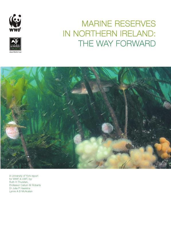
2 MARINE RESERVES IN NORTHERN IRELAND: THE WAY FORWARD Executive Summary A network of highly protected marine reserves is urgently needed to restore and protect Northern Ireland s marine environment Humans rely on the oceans for many resources, but after hundreds of years of exploitation the sea has been degraded, and is becoming less resilient to human impacts. If the sea is to continue to provide the goods and services that people depend on, some parts of it need to be protected from extractive use. This will help promote recovery from human impacts such as bottom dredging, aggregate extraction and aquaculture. Marine reserves (also known as highly protected marine reserves) are areas of the sea that are completely protected from the removal or deposit of living and non-living resources, and harmful levels of other damaging human activities. Non-damaging activities, such as wildlife observation, diving, swimming and sailing, can be allowed, so that people are able to enjoy marine reserves. Marine reserves provide benefits that cannot be achieved by other forms of marine protection or by management alone. They allow depleted species and habitats the opportunity to recover from damage caused by humans, and provide a haven for communities that cannot exist where fishing occurs. Reserves boost environmental resilience to human impacts and climate change by increasing population sizes and the reproductive output of marine species. Where reserves have been established, the population size of many exploited species has increased by 3-10 times or even more within 5 to 20 years after the onset of protection. The emigration of adult fish and dispersion of larvae into fishing grounds provides a means by which marine reserves are able to augment catches of commercially important species. The marine protection that is currently being applied throughout the UK is only directed towards a small selection of marine habitats and species, and does not provide enough protection from damaging activities to facilitate recovery from past losses. A network of marine reserves is essential to protect the entire spectrum of Northern Ireland s marine biodiversity and these should be established within a wider network of protected areas. Outside the highly protected areas other forms of management can be used to limit the damage caused by harmful human activities. This report sets out guiding principles and the beginnings of a process that could be used to establish a core of marine reserves in Northern Ireland that would complement and underpin existing protection and other management measures. Northern Ireland supports a wide variety of marine life and habitats including cold water corals, basking sharks and diverse reef habitats. One very notable site is Rathlin Island, where 50 percent of the UK s sponge species occur and where 29 new species have recently been discovered (Picton and Goodwin, 2007). Strangford Lough is another unique site with diverse seabed habitats such as eel grass and horse mussel beds and internationally important numbers of light-bellied brent geese. However current management has failed to adequately protect both of these valuable areas.
3 Although four percent of Northern Ireland s territorial waters are subject to some form of protective legislation, this is not meeting current conservation needs. It has now become urgently important to raise the level of marine protection afforded to Northern Ireland and to instigate marine reserves. To qualify as a marine reserve, a site should meet at least one of a number of important criteria. Examples of these include having a high diversity of wildlife, vulnerable or sensitive species, internationally or nationally important wildlife and unique or rare communities, as well as supporting habitats that are simply representative of their type. Key findings and recommendations: 1. Marine reserves have been set up throughout the world and should be established in Northern Ireland. A wealth of scientific literature exists about the benefits reserves provide and how to select sites for protection. However public awareness of this, even among users of the sea tends to be limited, with people failing to appreciate the impacts that past and present human activities have on marine life. Recommendation: Increase knowledge of marine reserve benefits in Northern Ireland through raising awareness and engagement with Members of Local Assembly (MLAs), governmental agencies, marine stakeholders and the general public. 2. A lack of trust and understanding between the Government and industries which use the sea creates obstacles to effective marine management. Recommendation: Improve communication and trust between people with different interests in the sea through open dialogue, such as public fora, public lectures and workshops to raise awareness, identify areas of conflict and resolve differences. 3. Government decision-making on marine management in Northern Ireland is highly fragmented at present with ten different management bodies responsible for marine affairs. Legislation has been developed in a piecemeal and sectoral way. Recommendation: Encourage Government departments to adopt a more holistic, ecosystem approach to marine management. A Northern Ireland Marine Management Organisation put forward under the proposals for Northern Ireland as per the UK Marine Bill would be an ideal way to coordinate management. 4. Northern Ireland has no legislation to create marine reserves. A process is required to establish reserves within a wider network of marine protected areas. Recommendation: Support moves to create an overarching legislative framework for Northern Ireland, which will deliver the requirements of the UK Marine Bill and meet the needs of Northern Ireland to protect and manage its seas. 5. Scientific and anecdotal information about Northern Ireland s coasts needs to be collated in the most informative way to identify sites for protection. Recommendation: Bring together stakeholders to pool information. Develop robust data sets. Begin a dialogue about marine reserves and identify priority sites for protection. A Marine Management Organisation for Northern Ireland would provide a centre for data exchange and expertise. 2
4 CONTENTS PAGE Executive Summary Introduction Scope and aims of the report Status and trends in Northern Ireland s seas Trends over time Emerging problems in vulnerable coastal seas Existing marine protected areas in Northern Ireland Current policy/legislation (UK and International) Recent legislation relating to marine activities in Northern Ireland Potential future legislation Marine reserves forming a core of higher protection Benefits of marine reserves Why Northern Ireland needs a network of marine reserves How can a network of effective marine reserves be achieved? Guiding principles for a Northern Ireland marine reserve network Goals and objectives Ecological criteria Identifying which areas not to protect How many reserves will be needed and how much of the sea should they cover? Potential economic and social benefits of marine reserves for Northern Ireland Examples of sites in Northern Ireland that would benefit from reserve protection Strangford Lough Rathlin Island The Skerries, Portrush The Maidens Red Bay Carlingford Lough Dundrum Bay (Murlough) Belfast Lough Lough Foyle North Antrim Coast Larne Lough The North Channel Pisces reefs Discussion and recommendations for the next steps Conclusions References...45 APPENDIX Examples of processes used to create marine reserve networks...54 APPENDIX Outcomes from Stakeholder Workshop, 27 th March ANNEX Examples of fishing activities in Northern Ireland s marine environment
5 1. Introduction Northern Ireland has a rich diversity of marine life extending from shores to open sea. This includes many different coastal environments, ranging from northern rocky shores exposed to the full Atlantic force, to sheltered inland sea loughs. Within Northern Ireland s undersea habitats are unique and fragile species and communities. They include horse mussel beds and maerl beds, corals and globally unique sponges, the latter only discovered by the Ulster Museum in 2007 (NIMTF 2007). Seals, dolphins, whales and basking sharks are regularly seen in coastal waters which also provide rich winter feeding grounds for internationally important wildfowl and waders. As in the rest of Europe, Northern Ireland s marine environment has experienced a long history of human exploitation and alteration. Resultant declines in fisheries and lost biodiversity both illustrate the need for new conservation measures. These are necessary so that damaged biological communities are given a chance to recover while they still can. 1.1 Scope and aims of the report This report addresses the need for an effective network of marine protected areas around Northern Ireland. In it we outline the beginnings of a process by which a viable network can be achieved to benefit marine biodiversity and those who depend on it for their livelihoods, recreation and quality of life. There are a number of initiatives at national and international levels that aim to build networks of marine protected areas. However, present marine protected areas focus on too small a range of habitats and species, and the protection they give is not strong enough to affect recovery from past impacts, or in many cases to prevent further degradation. This is because most marine protected areas try to accommodate existing uses of the sea and try to limit rather than halt damaging activities. Further protection is necessary if Northern Ireland s seas are to continue to prosper and provide vital goods and services in the future. A network of greater protection, in the form of marine reserves, is needed to complement existing marine protected areas. Marine reserves are areas of the sea that are completely protected from the removal or deposit of living and non-living resources, and harmful levels of other potentially damaging human activities. However, non-consumptive activities, such as wildlife observation, diving, swimming and sailing, can still be allowed, to encourage people to enjoy and value marine reserves for their wildlife and natural beauty. This report explores the effects of marine reserves on sealife and the benefits they can bring to Northern Ireland. There is conclusive scientific evidence that marine reserves provide benefits for biodiversity conservation and management of marine resources that cannot be provided by other means. The process described in the report to create an effective network of marine reserves is intended to complement existing marine protected areas and those that are being established, by providing an additional tier of protection that will strengthen and support partially protected areas. 4
6 In the following sections we discuss: The status and trends of Northern Ireland s seas What is being done to protect them, and the limitations of current management Why marine reserves are essential to protect marine wildlife and how they can be established, with examples from different sites around Northern Ireland 2. Status and trends in Northern Ireland s seas Northern Ireland s seas and coasts have been exploited and altered for thousands of years, so it is difficult to grasp the full sweep of changes that have occurred over time. The last couple of hundred years in particular have seen profound change. Marine habitats and communities have been altered by the effects of intensive fishing, pollution has affected coastal and inland areas, and the coastline has been transformed through coastal protection and land reclamation. The following section describes some of these changes and how they have affected Northern Ireland s seas. We then discuss more recent problems. 2.1 Trends over time For hundreds of years Ireland s coasts were noted for their wealth of marine life. In 1556 Spain paid 1000 a year to fish off the north coast of Ireland, whilst Charles I requested 30,000 from the Dutch to allow them to fish off the west coast (Royal Commission 1870). Before the 19 th century, Irish fishers targeted species in the numerous loughs and bays, as their small craft were unable to venture far offshore. These deeper waters were largely exploited by the then rapidly improving English and Scottish fishing vessels, which didn t welcome competition from Ireland (Royal Commission 1870). Even in the late 19 th century, when many inshore areas around England and Scotland were beginning to be described as exhausted, Ireland s coastal areas were described as containing vast shoals of fish (Royal Commission 1870). During the 19 th century, many loughs were made off-limits to trawling by the introduction of various byelaws (Brophy 1867) because of fears about its destructive effects on fish and their habitats. However, by the 1870s these regulations had been repealed in most of the northeastern loughs under pressure from the fishing industry (Holdsworth 1874). Declines in fish started to be noted in the late 19 th century and in 1889 an inquiry was launched into the alleged decreases. Many fishers gave evidence that fish abundance in inland and coastal waters had declined over the years, and the Commissioners concluded that a decrease had indeed occurred inshore. Trawling did not take place in all inshore areas, and it is likely that intensive line fishing also depleted some fish stocks. During the 1870s boats would travel from as far away as Scotland and Cornwall to take advantage of herring shoals that appeared along Ireland s coasts every year. Carlingford Lough also occasionally held large numbers of herring, with 15,000 being taken at one haul in 1805 (Smith 1923). During the early 18 th century Strangford Lough hosted an important herring fishery which involved up to 150 boats (Roberts et 5
7 al. 2004). However this fishery went into decline less than a century later, and by the mid-19 th century the small sizes of the shoals within the lough meant a directed fishery for herring almost disappeared (McErlean et al. 2002). A small-scale fishery persisted until the early 20 th century, but eventually collapsed in the 1930s (Roberts et al. 2004). It is likely that a number of factors, including over-exploitation, contributed to the decline in Strangford s herring stocks (McErlean et al. 2002). For many years oyster fisheries provided important food for coastal communities in Ireland. However with improved transport to markets, beds became over-exploited and some were destroyed (Went 1962). In the 1830s, Lough Foyle contained extensive oyster beds, and supplied oysters to Liverpool. At this time around 80 boats fished in the lough, but by the 1860s the number had almost halved. In the early 19 th century Belfast Lough was said to support an abundance of commercial fish species, including cod, sole, plaice, turbot, oysters and lobsters. At this time, the oysters in Belfast Lough were said to be as big as dinner plates (WWF 2006). However, by the turn of the 20 th century, the oyster beds had been severely depleted. Over the same period, the once renowned oyster beds of Strangford Lough also disappeared (Went 1962). During the early 19 th century, native oyster landings totalled around 1000 oysters per day from Strangford Lough, yet by the late 1800s landings had dropped to just 100 oysters per day. Legislation was brought about in 1878 to restrict the period of fishing for oysters, but this was not enough to save the dwindling fishery. By 1903 it had collapsed from over-exploitation (Roberts et al. 2004). By the latter part of the 19 th century, with so many natural oyster beds greatly depleted by over-exploitation, restocking with imported oysters had become standard practice in Northern Ireland s loughs. Carlingford Lough for example was the site of an important oyster fishery in the mid-1800s, but just a few years later the oyster fishery was so over-exploited that spat had to be imported from overseas to supplement the beds (Went 1962). Today, whilst fisheries around Northern Ireland are still relatively diverse, the overall composition of catches is dominated by invertebrates such as crabs, lobsters, Norway lobster (Nephrops norvegicus), mussels, king scallops and queen scallops. Economically the most important fishery is for Norway lobster. This is fished from the Irish Sea by the Northern Irish fleet, at what is thought to be a sustainable level (DOE 2006), although the fishery has significant wider impacts on fish and habitats. 59% of Northern Ireland s fishing vessels are less than 10 metres long, and a significant amount of the fishing still takes place in inshore waters (Inshore Fisheries Stakeholder Advisory Group 2007). Landings of many whitefish and flatfish species have declined in the last 35 years, while those of some invertebrates such as Norway lobster have shown recent increases. Drastic declines of some of the species illustrated in Figure 1 had already taken place by the early 20 th century, but the true extent of over-exploitation has been masked by technological improvements in fishing techniques that have helped prop up catch rates even as stocks decline. Maintaining a high fishing effort on stocks such as Norway lobsters is likely to reduce the chances of other stocks from recovering. The fine mesh nets and habitat-destructive trawling methods used to catch Norway 6
8 lobsters kill many fish and other species before they have been able to mature and reproduce. Intertidal fisheries are common and include those for mussels, periwinkles and cockles. Mariculture is also increasing in importance within some inshore areas. Currently there is no quantified information on intertidal fisheries in Northern Ireland, despite research suggesting significant impacts in some areas (Inshore Fisheries Stakeholder Advisory Group 2007). What is clear is that over the last one hundred years, the nature of fishing around Northern Ireland has dramatically altered. The situation has changed from one where large fish used to be plentiful in inshore catches to one where invertebrates dominate. Much of the diversity that was taken for granted in the 19 th century is now gone. 7
9 Atlantic Herring caught within Irish Sea region European Plaice caught within Irish Sea region Tonnes Tonnes Year Year Tonnes European Hake caught within Irish Sea region Year Tonnes Atlantic Cod caught within Irish Sea region Year Norway Lobster caught within Irish Sea region Great Atlantic Scallop caught within Irish Sea region Tonnes Tonnes Year Year Figure 1: Trends in fish landings from the Irish Sea since Data are from ICES FishStat Plus and include landings by a number of different countries. 2.2 Emerging problems in vulnerable coastal seas Fishing has many direct impacts on ocean ecosystems, including a reduction in the abundance and density of targeted species, collapses in their reproductive output, a decline in complex habitat cover and impacts on species at all levels of the food web (Jackson et al. 2001). Yet despite many years of expansion and growth of industrial fisheries, half of the world s catch is still caught in less than 10% of the ocean, mainly on the continental shelf and slope (Nellemann et al. 2008). Therefore even after hundreds of years of degradation and alteration, coastal seas still provide an extremely important food source for growing human populations. 8
10 However, in providing this food, large-scale fishing activities have sequentially depleted top predators, like cod, hake and halibut. This fishing down the food web has occurred all over the Northern Hemisphere in the last 50 years (Pauly et al. 1998). We have been fishing at unsustainable rates causing population decline and collapse, and now have to rely on fewer species. Although fisheries for Norway lobster may currently appear sustainable, studies have shown that populations in low diversity ecosystems are naturally less stable (Worm et al. 2006). Species in less diverse environments are more susceptible to disease and parasite outbreaks and do not recover as easily from disturbances (Worm et al. 2006). Hence an over-reliance on only a handful of fishery species is highly risky. As well as overfishing, many other human activities affect the marine environment and their impacts are increasing in number and magnitude. The consequence of multiple stresses affecting the sea is that resilience is declining; that is, the ability of habitats to recover from disturbance is impaired (Sala and Knowlton 2006). The increasing number of successful establishments by invasive species in heavily impacted coastal areas is one measure of this vulnerability. Simplified marine ecosystems are less resistant to invasion by exotic species. There is presently an invasive sea squirt from New Zealand found around the Carlingford Lough border which has the potential to heavily alter natural ecosystems and economic functions including aquaculture (Minchin and Sides 2006). It has been shown that the worst outbreaks in invasive species have occurred in intensively fished and polluted areas, where biodiversity has declined, and the marine environment has become unstable due to human disturbance (Nellemann et al. 2008). Hence a decrease in predators and competitor species appears to make ecosystems more prone to invasion by exotic species. Although legislation has improved the problem of pollution in many coastal areas, pollution from agricultural run-off and sewage still occurs, which can cause an increase in nutrients in estuarine and coastal water systems, potentially leading to outbreaks of harmful algal blooms. The cumulative impacts of destructive fishing methods, over-exploitation, pollution and invasive species are compounded by the effects of rapid human induced climate change (Nellemann et al. 2008). For years the oceans have buffered this problem by absorbing much of the excess carbon dioxide produced. Now this balance has reached a tipping point, as the oceans show signs of a decreased ability to continue this service. Increases in ocean acidity and temperatures and the possibility of changing oceanic circulation patterns have all become apparent (Greenpeace 2007). With anthropogenic climate impacts set to affect the oceans for many years to come, the ability of the marine environment to continue providing vital services for a growing human population has undoubtedly been compromised. Degraded and simplified marine systems are less resilient to environmental fluctuations and climate change. They are more subject to outbreaks of problem species like jellyfish and toxic plankton. The way we exploit and use the sea is storing up problems for the future. In order to counteract this problem, marine environmental managers need to take action to help reinstate greater resilience into natural systems, as well as providing protection for habitats which are still relatively intact. This can only be achieved by protecting areas of the sea from direct human impacts. Such protection will promote 9
11 biodiversity increase and allow the build-up of exploited populations to begin (Worm et al. 2006). By protecting areas of the oceans from direct pressures, the indirect impacts of accelerated climate change will be limited, rather than exacerbated. What is ecological resilience? Ecological resilience encompasses the ability of an ecosystem to regenerate following disturbance (Hughes et al. 2005). There are many examples in the sea where following the event of a one off, large-scale disturbance (for example an oil spill), ecosystems have been able to recover their normal functions and processes. However, an ongoing human activity such as fishing can impair the ability to bounce back. It does this by lowering species population sizes and production of young, degrading habitat complexity and causing disintegration of food webs. Sensitive species and even habitats can disappear from highly affected areas. Human influences have changed the structure of marine communities and populations. Although human impacts differ in terms of their severity and the timescales over which they operate, their cumulative effect is to undermine the ability of marine communities to recover from disturbance in general. Once resilience is reduced, collapses in communities (and often our resources) can occur swiftly and with little warning. In the event of a man-made or natural catastrophe an already degraded environment may be unable to recover (Worm et al. 2006). In order to rebuild ecological resilience, species and natural processes must be allowed to reassert themselves through protection. Within Northern Ireland, there are a number of different types of fishing methods that cause impacts to the marine environment. These include dredging and trawling for species such as scallops and Norway lobster, as well as more labour intensive methods such as collecting animals such as periwinkles and cockles by hand on the foreshore. Other activities such as aquaculture also take place in many inshore areas such as loughs and sheltered bays, this can have impacts on the targeted area as well as species that use the area for food and breeding. These impacts are described in more detail in Annex Existing marine protected areas in Northern Ireland The World Conservation Union (IUCN) has defined a marine protected area (MPA) as any area of intertidal or subtidal terrain, together with its overlying water and associated flora, fauna, historical and cultural features, which has been reserved by law or other effective means to protect part or all of the enclosed environment (Kelleher and Graeme 1998). The term marine protected area can encompass a wide range of protection within the sea. Whilst many people believe that an MPA halts all damaging activity, in many cases this does not happen, and there may be very little real protection. 10
12 Northern Ireland has several different types of MPAs that have been set up for conservation purposes. The following section describes what these are and what they are intended to achieve. 3.1 Current policy/legislation (UK and International) In 2002, the joint UK administrations set out a vision of clean, healthy, safe and biologically diverse oceans and seas. Their vision is to conserve ecosystems, ensure long-term social and economic benefits and to increase our understanding of the marine environment and its natural processes (DEFRA 2002). In 2005, marine nature conservation objectives were set out which included a desire to halt the deterioration of the marine environment and to promote recovery. It was recognised that the support of healthy, functioning and resilient marine environments where habitats, species and natural processes are sustained, is necessary if we are to conserve marine ecosystems (DEFRA 2005). International agreements and European Conventions also commit the UK to protect marine species and habitats. For example the goals of the OSPAR Convention of which the UK is a member, include a commitment to protect, conserve and restore species, habitats and ecological processes that have been adversely affected as a result of human activities. This legislation aims to create a network of marine protected areas to be designated by 2010 (OSPAR 2003). Other international commitments to identify areas for special protection to which the UK is party include the Convention on Biological Diversity (1992) and the World Summit on Sustainable Development 2002 (the Johannesburg Declaration). Both of these require the establishment of a national network of marine protected areas by 2012 (House of Commons 2007). In addition, EU commitments require each member state to designate Special Areas of Conservation (SACs) under the EC Directive on the Conservation of Natural Habitats and of Wild Fauna and Flora (the Habitats Directive, 92/43/EEC) and Special Protection Areas (SPAs) under the EC Directive on the Conservation of Wild Birds (the Birds Directive, 79/409/EEC) 1. Under the Habitats and Birds Directives, responsible departments must maintain or restore to favourable conservation those features (either habitats or species) for which a site has been designated as an SAC or SPA. Implementation in Northern Ireland The Environment and Heritage Service (EHS) is responsible for nature conservation in Northern Ireland. The most important piece of domestic legislation for site-based conservation is the Nature Conservation and Amenity Lands (Northern Ireland) Order 1985 which allows for the designation of National Parks and Marine Nature Reserves (MNRs). Areas of Special Scientific Interest (ASSIs) legislation is contained within the Environment (Northern Ireland) Order
13 International site protection is also the responsibility of EHS (Kelso and Service 2000). We describe below conservation designations that are extended to parts of the marine environment in Northern Ireland, and their limitations. Marine Nature Reserves (MNRs) Marine Nature Reserves can be designated throughout territorial waters from land to three nautical miles out to sea. Northern Ireland has one Marine Nature Reserve at Strangford Lough. Local byelaws can be constructed to deal with specific threats to habitats and species so that each MNR can operate at a local level. A number of flaws weaken the usefulness of this designation. For example, byelaws created for the MNR cannot interfere with any other regulatory body s rules, so many users, for example, fishers, are exempt from regulations (Boyes et al. 2003). In order to set up an MNR all interested parties need to reach consensus on the designation. Hence, one objection has the power to stop the whole process (Roberts et al. 2003a). This has led to only three MNRs being established in the whole of the UK, each with only limited power to protect a handful of habitats and species. Extent of MNRs in Northern Ireland Special Areas of Conservation (SACs) and Special Protection Areas (SPAs) Special Areas of Conservation are designated under the European Habitats Directive and have been implemented to protect a list of species and habitats of conservation importance at a European level. Northern Ireland has six SACs with marine elements, such as Rathlin Island and the North Antrim coast. Special Protection Areas are designated under the European Birds Directive and list bird species which are vulnerable or rare at a European level 1. There are eight SPAs set up to include marine bird species in Northern Ireland. Examples include the designation of Belfast Lough for an internationally important breeding population of redshank (Tringa tetanus) and Carlingford Lough which hosts an internationally important population of sandwich terns (Sterna sandvicensis). A network of SAC and SPA sites together are known in Europe as Natura 2000 sites 2. This network was originally to be completed by 2008 with management agreed and
14 instigated by , although the 2008 date has been extended for Northern Ireland. SACs can extend throughout the territorial seas into offshore areas beyond 12 nautical miles. Once sites are designated, they need to be monitored to determine whether they are in a favourable, improving or declining condition. Under the Habitats Directive, SACs must be maintained at favourable conservation status. This addresses the need for long-term viability of populations, based on measures such as whether a range is stable or increasing and if the structure and functions necessary for its long-term viability exist and will continue to do so 4. In the terrestrial environment in Northern Ireland, SACs and SPAs are underpinned by the more robust ASSI legislation, but in the sea ASSIs are limited to the intertidal zone (see below). Although SACs extend throughout and beyond UK territorial waters, they only protect a relatively short list of species and habitats that are important from an EU perspective, and SPAs only protect certain bird species. These are not necessarily sites that are important at a local or national level. As the designation of sites corresponds only to certain species and habitats, SACs are not established to provide connectivity between sites in ecologically functioning networks. Unlicensed activities in marine SACs are hard to control, and any measures to prevent damaging activities are very much reactive and only respond to actions that have already occurred, rather than taking a precautionary approach. SACs are only intended to manage human activity rather than to prevent exploitation and harm (Dernie et al. 2006). Extent of Marine SACs (left) and SPAs (right) Areas of Special Scientific Interest (ASSIs) Areas of Special Scientific Interest are areas that have been identified as having a high conservation value (through scientific survey) 5. ASSI legislation sets out a list of notifiable operations which may harm the conservation interests of a site. If declared owners or occupiers (for example the landowner) wish to carry out an activity on this list, they must first enter into a management agreement with the Environment and Heritage Service 5. Objections cannot stop the designation of an area as an ASSI, and
15 statutory bodies have to issue permits before any activities included on the list of notifiable operations can be carried out 6. Although the legislation that underpins ASSIs is robust, any protection that extends into the marine environment only goes down to the mean low water mark (House of Commons 2007). This means that ASSI legislation cannot be used to establish fully submerged reserves unless the proposals, under the UK Marine Bill White paper to establish SSSIs below the low water mark are taken forward and implemented in Northern Ireland. Furthermore ASSIs rarely prohibit extractive activities (Dernie et al. 2006). Extent of Marine ASSIs World Heritage Sites (WHS) Part of the North Antrim coast, the Causeway Coast, was designated as a UNESCO World Heritage Site in This site includes a marine element (160 hectares of sea) and has a management plan aimed at achieving a sustainable future for the Causeway Coast. However, the World Heritage Site is not a statutory designation, so the management plan is implemented within the context of many different levels of policy, from local byelaws to international legislation (EHS 2005). The Causeway Coast WHS is an internationally important ecological reserve. Its unique coastal and underwater topography creates a diverse underwater landscape of high biodiversity which is important for a number of bird and mammal species. The management plan for the area is mainly focused on controlling impacts from the high number of visitors the area receives every year, and can do little to actively protect the sea area. Areas of Outstanding Natural Beauty (AONBs) Areas of Outstanding Natural Beauty were created to protect landscapes by controlling development, so the designation of sites is based on landscape features rather than the ecology of an area. However, it wasn t until the provision of the NCALO (1985) legislation which strengthened the powers of the Department of the
16 Environment that positive management really began (EHS 2003). The responsibility of maintaining AONBs lies with local authorities and is very much community-based. Whilst actions to conserve the landscape are encouraged, including the use of grant schemes to alleviate financial hardship for affected landowners, the designation of sites doesn t extend below the mean high-water mark for the majority of AONBs (Bann and Cooper 2002). Extent of Marine AONBs Ramsar sites The UK is contracted to the Convention on Wetlands of International Importance, which is an intergovernmental treaty designed to conserve wetlands through national and international action 7. Areas identified under this convention are known as Ramsar sites, and can include fresh, brackish or marine waters. The aim of these designations is to stall the loss of wetlands and stem encroachment by industries onto identified sites. Sites can be designated under a number of criteria, such as the presence of internationally important, rare or vulnerable species, or a high diversity of wildlife. Boundaries of sites are often coincident or similar to established ASSIs or SPAs. There are five Ramsar sites containing coastal elements within Northern Ireland. This includes Belfast Lough, designated for its nationally important populations of shelduck (Tadorna tadorna) and oystercatcher (Haematopus ostralegus), among others. Lough Foyle is another example, which qualifies under a number of Ramsar criteria, such as being a representative example of a wetland complex 8. Ramsar sites would not be suitable for use as marine reserves, as the designation of sites stops 6 metres below mean low water 9. Neither does the designation of a wetland or estuarine area under the Ramsar Convention protect it from activities such as fishing. Instead, the Convention focuses on the wise and sustainable use of wetlands and resources, rather than completely halting harmful activities
17 Extent of Marine Ramsar sites Despite the list of current conservation designations, it is clear that full marine protection cannot yet occur under existing legislation. For example, a number of damaging and extractive activities occur in supposedly protected areas around Northern Ireland s coast, and many of these are largely unregulated. 3.2 Recent legislation relating to marine activities in Northern Ireland As well as the protected area designations listed above, there are other pieces of legislation that aim to control human impacts on habitats and species in Northern Irish waters, some of which comes from fisheries regulations. The Department of Agriculture and Rural Development (DARD) has responsibility for fisheries within the Northern Ireland zone, most of which is within 12 nautical miles. A number of fishery regulations exist to restrict certain activities to attempt to conserve stocks or protect habitats. One example is suction dredging for razor clams, which occurs in some coastal areas throughout the UK. This is a highly invasive mode of fishing, performed in very shallow water close to shore that can have large knock-on effects on biological communities (Moore and Service 2001). The procedure involves fluidising sediment by strong water jets, then drawing this up through a suction pipe. This activity was first banned in Dundrum Bay and Strangford Lough under the Inshore Fishery Regulations (Northern Ireland) The Department of Agriculture and Rural Development (DARD) are now looking to ban suction dredging in the near future under the Inshore Fishing (Prohibition of Fishing and Fishing Methods) (Amendment) Regulations (Northern Ireland) 2007 before any significant fisheries can become established (DARD Fisheries Division communication). The findings of the Strangford Lough Ecological Change Investigation (SLECI) in Strangford Lough, showed that large amounts of damage had occurred to the horse mussel communities (Modiolus reefs) from trawling and dredging in the last 25 years (Roberts et al. 2004). Previous surveys between 1975 and 1985 had found clumped, intact communities of horse mussel reefs in the North Basin, whereas in the latest surveys many of the reefs were dead, with only the occasional live animal remaining. 16
18 It was concluded that the damage caused to the reefs had most likely been caused by dredging and trawling (Roberts et al. 2004). This caused DARD to introduce a ban on all mobile fishing gear within Strangford Lough from December 2003 (DOE/DARD 2006). The ban currently remains in place and was extended indefinitely in 2004 (DARD Fisheries Division communication). 3.3 Potential future legislation Non-disturbance zones in Strangford Lough In November 2007, DARD issued a public consultation document which proposes a restoration plan for the horse mussel beds in Strangford Lough. The proposal is to protect the two best remaining areas of Modiolus horse mussel reef from any humanderived threats by creating two non-disturbance zones around them. These zones will prohibit sea fishing in these areas 10. The consultation has arisen as the horse mussel reefs within the Strangford Lough SAC are currently in unfavourable condition, and this must be addressed in order to comply with the Government s obligations under the EC Habitats Directive. Whilst this may be a step towards allowing parts of the horse mussel beds to recover within Strangford Lough, the proposed non-disturbance zones are small, and will only provide limited protection to parts of the remaining horse mussel communities and their associated biodiversity, rather than for the population as a whole. Neither does the proposed protection take into account the need to provide long-term protection for other species in this diverse ecosystem. The UK Marine Bill The UK Marine Bill White Paper A Sea Change was launched in March 2007 by the Department of the Environment, Food and Rural Affairs (DEFRA) to set out proposals to reform marine management in the UK. When implemented this Bill should provide the opportunity to transform marine management from what is often conflicting and piecemeal legislation to an overarching framework that includes longterm sustainable fisheries management and conservation of the seas (DEFRA 2007). In Northern Ireland, whilst fishing activities are regulated by the Department of Agriculture and Rural Development (DARD), the creation of marine protected areas falls under the jurisdiction of the Environment and Heritage Service (EHS), an agency of the Department of the Environment. There is little integration of fisheries and environmental protection, for example, many aspects of the draft UK Marine Bill look set to be introduced into Northern Ireland primary legislation in the future, whilst DARD fisheries are not yet incorporated into this overarching policy. This indicates a lack of integration and differing opinion between different departments, which needs to be resolved if fisheries are to be integrated into an ecosystem-based management of Northern Ireland s seas
19 Given the range of increasing pressures on Northern Ireland s marine resources, many of which compete for space, it is vital that DARD enter into a sustainable long-term approach together with other Government Departments to manage the marine environment, including on spatial protection measures such as MPAs and marine reserves. As many fisheries resources are declining through long-term management failure, other activities such as aquaculture are increasing in importance. Aquaculture activities are also licensed by DARD 11 and they need to be set in an overarching framework, with sea-fisheries, that encompasses the many different uses within the marine environment, as well as serving the wider interests of the Northern Irish people, whilst providing for long-term conservation benefits that will enable marine ecosystems to recover and resources to continue. 4. Marine reserves forming a core of higher protection Marine reserves are areas of the sea, including the seabed, overlying waters and associated flora and fauna, that are protected from extraction and deposition of living and non-living resources, and harmful levels of all other damaging or disturbing activities. They can be established from the intertidal zone to areas of open sea. At present only about 1/50 th of 1% of the UK s exclusive economic zone is a marine nature reserve and only 1/50 th of this is off-limits to all extractive or harmful activity. Marine reserves may be placed in areas where there are no other forms of protection, or where some lower level of protection already exists, for example within a Special Area of Conservation. A suite of marine reserves situated within a larger network of MPAs is fundamental to the effective protection of the marine environment. Marine reserves offer protection that can achieve objectives beyond the reach of less protected MPAs, and as such need to be used to complement and bolster existing protection. This report makes the case for incorporation of an ecologically effective network of marine reserves to complement existing management and provide benefits which current forms of protection cannot provide, such as recovery of vulnerable habitats and species. Marine reserves have proven highly effective in other countries as tools to facilitate recovery of declining habitats and species (Polunin and Roberts 1993; Chapman and Kramer 1999; McClanahan and Arthur 2001). Integrated alongside existing marine protected areas, fisheries management and other regulations, they can provide a more secure future for marine life and those who depend upon these resources for their wellbeing and livelihoods. 4.1 Benefits of marine reserves Marine reserves are not a new phenomenon and many countries are building networks of reserves to counter overexploitation, facilitate recovery of damaged and degraded habitats, and support fisheries management. In view of the perceived value of reserves as a management tool, some nations, such as South Africa and Pacific Island states have set ambitious targets to establish reserves over 20 or 30% of their marine waters (Roberts et al. 2005). Numerous scientific studies now demonstrate the benefits that marine reserves can bring to temperate marine ecosystems, and there is
20 an increasing literature on the process by which networks of reserves have been set up (see Appendix 1). Biodiversity benefits The benefits of marine reserves for marine biodiversity have been well documented (see Halpern 2003 for an overview). Marine reserves can recover ecosystem structure and function by protecting habitats from damaging fishing gear and other destructive impacts, and protecting biodiversity at all levels (Bohnsack 1998). This in turn provides societal and economic benefits in terms of improved water quality, increased productivity and food availability (fisheries) and increased ecosystem resilience (Worm et al. 2006; Beaumont et al. 2007; Danovaro et al. 2008). Inside reserves animals live longer, grow larger and increase in abundance and density. Since big animals produce many times more offspring than small, these effects translate into much higher levels of reproduction and enhanced replenishment of populations. Inside reserves, different communities develop that cannot survive intensive fishing and other kinds of harm, and vulnerable species and habitats begin the process of recovery. Marine reserves have been found to have rapid and lasting effects. Halpern (2003) found that on average in reserves, population densities increased by 91% and biomass increased by 192%, with effects being seen within the first couple of years. That said, the full recovery process takes decades as longer-lived and slower growing species respond over long timescales. Protected habitats have been found to recover in both temperate and tropical environments. For example in New Zealand, kelp forests increased in marine reserves. They had previously been wiped out by enlarged populations of grazing sea urchins whose predators had been overfished (Babcock et al. 1999). Marine reserves are the only tool we have that can fully protect vulnerable habitats and species from direct human impacts, as even moderate fishing or damage can impact species which mature late and reproduce slowly. By excluding extractive and damaging human activities in certain areas of the marine environment, vulnerable communities that cannot survive elsewhere will be able to prosper. In addition, marine reserves can help foster greater understanding and appreciation of marine life. They can provide a baseline of what an ecosystem looks like that isn t being subjected to fishing pressure or other impacts, thereby enabling more informed management decisions to be made for other areas of the sea. Long-established marine reserves have proven extremely popular for tourism and recreation, drawing people from far afield to see their abundant and spectacular marine life. Fisheries benefits There are two mechanisms by which fisheries can be enhanced through the use of marine reserves: these are the spillover of individual fish from the reserve into adjacent fishing grounds, and the export of eggs and larvae on ocean currents. In the Caribbean island of St Lucia, for example, the amount of fish within a network of marine reserves increased almost five times after only seven years of protection, whilst on adjacent fishing grounds fish populations tripled (Hawkins et al. 2006). After just five years of protection, fish catches had doubled in surrounding areas 19
21 (Roberts et al. 2001). Evidence for outward migration of fish from reserves can be found at Merritt Island Wildlife Refuge in Florida. There, catches of world recordsized game fish around the borders of the Refuge greatly exceed any other area on the coast. This area covers 13% of the Florida coastline, but accounted for around 50% of world record catches for three species studied (Roberts et al. 2001). At present the UK only has one marine reserve zone which covers just 3.3km 2 at Lundy Island off the North Devon coast. Since protection was instigated in 2003 the abundance of lobsters which are greater than the minimum landing size has increased by seven-fold within the reserve. The spread of small lobsters (Homarus gammarus), which are less than the minimum landing size, from within the marine reserve into adjacent areas has provided evidence that spillover is occurring (Hoskin 2007). Examples where fisheries have been enhanced by export of larvae from marine reserves are well illustrated by relatively immobile species. Following the closure to mobile fishing gears of parts of Georges Bank off the eastern United States, legal sized scallops increased by 9-14 times within five years (Murawski et al. (2000) and have continued to grow since, helping supply a thriving scallop fishery in surrounding areas. The closures have also led to much increased stocks of haddock, and now three-quarters of the US haddock catch is taken within five kilometres of the borders of closed areas as haddock spill out into surrounding fishing grounds (Murawski et al. 2005). In Fiji, a protected area increased the weight of mud-flat clams by 13 times in three years, and increased their abundance outside the reserve by five times (Gell and Roberts 2003). Reserves can benefit fisheries for mobile species if they are established in areas that are vital for vulnerable stages in life histories, for example, at spawning or nursery grounds. Additionally they may help if recovered habitat provides improved feeding opportunities for wide ranging species (Gell and Roberts 2002). Marine reserves are also widely thought to provide insurance to the fishing industry, protecting against fishery collapses and giving fishers a greater security of income (Roberts et al. 2005). They do this by protecting exploited species so they live longer, grow larger and become more numerous, as noted earlier. Because large animals produce many more offspring than small, extending population age structures and increasing the amount of large, old, highly productive fish will substantially increase egg production. Older fish may also produce better quality eggs and their offspring survive better than those from small fish (Berkeley et al. 2004). In addition, older fish may be more experienced and better able to successfully reproduce than young. In combination, these effects mean that populations with extended age structures and many old fish should lead to less variable replenishment of populations over time, a prediction that has been upheld by research (Hsieh et al. 2006). These effects should simplify management, since stocks and therefore catches will be easier to predict and be more stable over time. This means that marine reserves can offer insurance against fishery collapse from environmental uncertainty. Protected populations can also provide insurance against management errors and management compromises (e.g. between fishery sectors). 20
22 4.2 Why Northern Ireland needs a network of marine reserves Human influence on the sea has altered entire ecosystems, resulting in biodiversity losses which range from abundance reductions to the complete removal of top predators (Roberts 2007). Marine conservation efforts are usually targeted at specific groups of animals or specific habitats, yet the open nature of the sea means that many habitats are directly linked through physical and biological processes. Therefore it makes more sense to direct management at the ecosystem rather than the species level. It has also been shown that protecting many species allows for ecosystem multifunctionality, that is, the management and conservation of ecosystems to support multiple ecological processes and functions. Hector and Bagchi (2007) showed that biodiversity loss affects ecosystem functions and services to people. They concluded that because different species often influence different functions, studies focusing on individual processes in isolation will underestimate levels of biodiversity required to maintain multifunctional ecosystems. Broad based protection of whole ecosystems is therefore necessary to sustain ecosystem functions and the services that depend on them. Human populations rely on many goods and services from the ocean, and in order to sustain supplies of them over the long-term, we need to replace lost biodiversity and increase the resilience of marine ecosystems. A century of short-term thinking in management has gradually ratcheted down populations of marine life, reducing our ability to draw benefits from the sea. For example, landings of fish into England and Wales fell by 94% over the course of the 20 th century, a consequence of a fishinginduced reduction of 90% in stocks of large-bodied fish species (Christensen et al. 2003). Rebuilding of depleted stocks with marine reserves and improved fisheries management is vital to assure more reliable food sources for the future, as well as other benefits. If we continue to exploit all of our seas, then biodiversity loss will accelerate, precipitating further resource collapses and growing scarcity of seafood (Worm et al. 2006). People are sometimes fearful about marine reserves because they worry that they will prevent them from using or enjoying the sea. We use the sea intensively in coastal areas and so it is not desirable or socially acceptable to cut people off from large areas of the sea. But this is not what marine reserves are intended to do. Protection from extractive and harmful uses does not mean that reserves are no people zones, far from it. Reserves instead redistribute some activities along coasts, enhancing opportunities for non-consumptive uses inside reserves, such as recreation, and permitting fisheries, other industries and potentially damaging activities in different areas. In order to distribute benefits (and any costs) of protection, it is better to create networks of reserves spaced along coasts than to establish large, isolated reserves. This ensures that people can have ready access both to protected and less protected sites. An extensive network of reasonably sized marine reserves will bring benefits that are greater than the sum of their parts. Both biodiversity and fisheries stand to benefit with a spread of reserves together with controlled use of the areas in between (Roberts et al. 2005). Creating marine reserves as part of a network helps maximise the benefits of protection with minimum disruption to stakeholders. Networks can help protect ecosystems at a large scale through recovery and enhancement of populations and 21
23 habitats and maintaining the vital processes that link communities together. This is an essential line of defence to prevent large-scale ecosystem collapse, a goal beyond the scope of small-scale management. Marine reserves in the context of Marine Spatial Planning Marine spatial planning is a process by which the sustainable exploitation of marine resources can be planned and managed within a broad framework (DEFRA 2003). We take this approach for granted on land, where different places are zoned for different uses, such as housing, versus industry, versus green belt. Marine spatial planning will bring together different and sometimes conflicting legislation and policies to enable faster decision-making and better management at an ecosystem level. It should enable management of the seas to move from being largely reactive, to a more proactive approach that is directed towards longer-term goals and objectives (WWF 2004). It is vital that the spatial framework is underpinned by an ecologically viable network of marine reserves that form a core of strong protection, in order for economic and social benefits to accrue. The proposed UK Marine Bill should provide an overarching marine policy statement that will set long-term objectives for sustainable use of the marine environment, including conservation. It will create legislation that allows the formation of highly protected marine reserves as part of a broad spatial plan. Although Northern Ireland s position regarding the Marine Bill is currently unclear, a similar approach should help foster greater coordination and cooperation in marine planning. 5. How can a network of effective marine reserves be achieved? In the following section we outline a process that could be used to establish a network of marine reserves around Northern Ireland. This will build upon other processes that have been used in different areas throughout the world, and the lessons learnt from these (see Appendix 1 for examples of processes). 5.1 Guiding principles for a Northern Ireland marine reserve network To create an ecologically effective network of marine reserves, it has been recognised at an international level that there must be a set of guiding principles that underpin network design. The Convention on Biological Diversity has published guidelines on establishing protected area networks that set out key principles (CBD 2004). These include: Representativeness: to represent the full spectrum of biodiversity, all biogeographic regions and major habitat types should be included within a network. Replication: all habitats should be replicated in different reserves to safeguard against management failure, catastrophes or the unexpected collapse of populations. 22
24 Viability: the network should be ecologically viable and be able to sustain itself should populations outside reserves collapse from management failure or catastrophe. Viability is increased if the majority of species home ranges are encompassed within reserves. Connectivity: to ensure linkages among protected populations and habitats within the reserve network, sites should be connected through transport of eggs, larvae, seeds and spores, as well as movement of adult and juvenile animals. Precautionary design and use of best available scientific evidence: where there is uncertainty the precautionary approach should be favoured to protect biodiversity. To prevent delays, the best available scientific evidence should be used to make decisions rather than delay for more data and risk greater damage. The application of the above principles will be described later on. 5.2 Goals and objectives One of the earliest priorities when establishing a marine reserve network must be to determine what the goals are. In many countries, stakeholders have been actively involved in goal setting, helping to create a shared vision for what they want from the sea and from a reserve network. Planning and design of the network and consultations about it can then be performed in light of these objectives, ideally alongside efforts to inform the wider public of the need to protect the sea. Typically, goals in other countries have included protection and recovery of biodiversity, improved water quality, enhanced recreation and tourism opportunities, support for fisheries management and conflict reduction among different users. Once the goals are set, sites for marine reserves are chosen on the basis of criteria that have been selected to assure that the network achieves these goals. 5.3 Ecological criteria Marine reserves will be of little value if they do not protect places which are important to marine life. Hence, ecological criteria for choosing reserves are usually applied ahead of any others. That said, giving a site protection from extractive and harmful uses will lead to a greater abundance of life as time goes on, so the choice of sites must be driven by their potential to support sea life as well as what is present at the time of reserve selection. Most of the ecological criteria that have been used to establish networks of marine reserves throughout the world could be applied to the process in Northern Ireland. Some of the most frequently used criteria are listed below. 23
25 Representation The open and fluid nature of the marine environment means that most species and habitats depend to a greater or lesser extent upon other ecosystems and are affected by processes which operate outside that of their immediate realm. For example, few marine species use just one type of habitat during their lifecycle. To preserve ecosystem function, and protect the full variety of life, all habitats within a region need to be protected. The importance of this was recognised in Australia in 2004 when the Great Barrier Reef marine park was re-zoned to include marine reserve zones for all ecosystems, not just for coral reefs which had previously been the case. The first step in reserve network design is to define and map biogeographic regions and major habitat types. This classification can then be used as a basis to protect a representative range of habitats and places. Biogeographic regions are assemblages of plant and animal communities that can be defined by physical (e.g. ocean currents, topography of the seabed), biological and climatic limits. They contain communities which are distinct from those in different biogeographic regions 12. In Northern Ireland s waters, there are no more than one or two biogeographic regions. The exact definitions and boundaries will need to be defined by experts and stakeholder groups using physical and biological information on the topography, oceanic conditions and biological communities present. This will take into account the very different conditions encountered on the east coast, where the Irish Sea dominates, and the north coast which is more open to the North Atlantic. Replication of habitats Replicating habitats and populations within different protected areas helps safeguard against catastrophes or unexpected population collapses. New Zealand s network design principles incorporate a minimum of two replicates of each habitat represented in the network, but it has been suggested that this should be increased for more vulnerable habitats (Department of Conservation and Ministry of Fisheries 2005). Others have recommended three to five replicates (Roberts et al. 2003b). Site integrity Site integrity can be defined as the degree to which an area is self-sustaining and viable over the long-term (Salm et al. 2000), that is, can populations within it survive if surrounding habitats become degraded? Areas that rank highly in this respect should be considered prime candidates for protection. Protecting places with a high level of site integrity will help prevent habitats becoming fragmented and promote the maintenance of viable population sizes. This will increase the overall resilience of the reserve network to outside influences. The Great Barrier Reef marine park provides an example where site integrity was incorporated into designing a marine reserve network. Here, the different zones established have been created in different shapes and sizes, where the shortest side of any marine reserve zone is not less than 20km in length (Fernandes et al. 2005)
26 Within Northern Ireland s territorial waters, site integrity can be improved by taking care not to fragment habitats such as salt marshes or reef communities. Sensitivity/vulnerability Sensitive or vulnerable areas are those which contain a high proportion of species and/or habitats that are sensitive to disturbance and are usually slow to recover (OSPAR 2003). Because of their vulnerability, they require high levels of protection to persist or recover and should be a high priority for inclusion in marine reserves (Dearden and Topelko 2005). Vulnerable and sensitive habitats in Northern Ireland include regionally rare eelgrass beds and saltmarshes as well as maerl beds along the northeast Antrim coast and horse mussel reefs in Strangford Lough (Roberts et al. 2003c). Vulnerable life stages of species can also be considered within this criterion. For example areas which support spawning aggregations and feeding and nursery grounds should be given a high priority for protection, especially if the reserve network aims to benefit fisheries (Roberts et al. 2003c). Productivity Areas of high productivity typically support high biodiversity and abundance of associated species including top predators (Worm et al. 2005) and are often subject to intensive fishing (Worm et al. 2005). Closing such areas to fishing is difficult to achieve socially, but is very important to marine reserve networks since doing so will provide protection to many mobile commercial species at times and places when they are particularly vulnerable to capture. The North Channel, for example, hosts a number of rocky reefs with expanses of mud which contain commercially important populations of Norway lobster. Protecting a proportion of this area would protect fishing interests over the long-term as well as protecting the more diverse reefs from damage. Global/regional importance Areas of global or regional importance should obviously be included in any protected area network. For example, in Northern Ireland up to 75% of the world population of brent geese over-winter in Strangford Lough where they feed upon eelgrass and algae (Moore and Service 2001). Recent monitoring efforts by the Ulster Museum have discovered many new species of sponge around Rathlin Island off the North Antrim coast. These sponges are globally unique illustrating the individual nature of the island and how species can go unnoticed for generations, especially in the sea. Rarity Habitats and species can be rare if they have a limited distribution. Widespread or mobile species can also be rare if their distribution is patchy or the overall population size is low. If the population size of a species or its extent of occurrence is uncertain 25
27 or unknown, the precautionary approach should be applied when making decisions under this criterion. This is especially important if species or habitats in question are particularly vulnerable to human disturbance or over-exploitation, which is the case for many naturally rare species. Those species and habitats which are rare because of historical or recent exploitation should be prioritised for inclusion in the network, before populations drop below a viable size and recovery becomes impossible. Rarity can be assessed at different levels, including national, regional and global, with weightings for protection increasing from national to global status. Dearden and Topelko (2005) provide guidelines on how rarity should be assessed. Any areas which are prioritised for this reason should aim to be large enough to protect a viable population and to minimise edge effects at the boundaries of reserves where possible. The new sponges discovered around Rathlin Island, for example, appear to be regionally rare and highly sensitive to human disturbance and have a high priority for protection. Uniqueness Uniqueness is an important concept because as well as encompassing individual species and habitats, it can also be applied to communities, assemblages and geographical features that are unique to Northern Ireland or even unique on a global scale. This criterion is particularly important because unusual features or communities may facilitate environments and processes which do not occur elsewhere. Good examples from Northern Ireland include the steep underwater cliffs on the north side of Rathlin Island, which drop to 200 metres and provide an environment found nowhere else in the country. Horse mussel reefs in Strangford Lough could also be included under this criterion, as although the species itself is not unique, the aggregating assemblages in the lough are uncommon and nationally important for biodiversity. Naturalness/typicalness The naturalness criterion assesses the extent to which species and/or habitats appear to be unaffected by human degradation (OSPAR 2003). Basing protection on a positive ranking for this criterion provides an opportunity for proactive rather than reactive management. However, in many temperate ecosystems it is hard to know what the natural state actually is since the marine environment has undergone so many changes over the last few hundred years. As a result, many habitats have shifted into alternative states and now support completely different species compared to what they once did. Protection may eventually lead to some recovery, although not necessarily to a previous state if some threshold has been crossed. Even then such areas may still be important to conserve if they are typical of the local marine environment (Dearden and Topelko 2005). The creation of marine reserves will help increase understanding of what the natural state of the marine environment is like. 26
28 Functionally critical habitat The protection of functionally critical habitat such as important feeding areas, nursery grounds and spawning aggregation sites will enhance an area s ability to support species, including those of commercial importance (Roberts and Hawkins 2000). Populations of some mobile species experience periods called migration bottlenecks in which numbers build up at predictable times and locations due to concentrated feeding activity, resting periods or breeding sites (Roberts and Hawkins 2000). These areas provide easy targets for fishers and make excellent places to protect species when they are at their most vulnerable. Contains species/populations of special concern This criterion addresses the need for protected areas to incorporate rare and/or unique species and populations within their boundaries. This definition should also be extended to include commercial species which although not rare or unique, need to have refuges free from exploitation. The criterion can also be applied to species or populations that are important for activities such as tourism (for example seals, sea birds and basking sharks) or scientific research and monitoring. It is also highly relevant in areas where recent or historical declines in population numbers have been highlighted (Roberts et al. 2003c). Many population collapses have been documented in Northern Ireland s sea. Examples include herring, oysters and Strangford Lough s mussel beds. As a case in point, the variety of species and communities that are under threat in Strangford Lough would qualify parts of it most highly for protection under this criterion. Connectivity/Ecosystem linkages The study of connectivity between different marine habitats is an advancing science, and many gaps still exist in our knowledge. What we do know is that many marine organisms depend upon more than one type of habitat and will move between these to a greater or lesser extent. In the dispersal phase, species seeds, spores, eggs and larvae are transported by oceanic currents. This can be either actively, passively, or a combination. Marine reserves need to be close enough together to allow dispersal of offspring between protected areas. If fisheries management is a goal, their size should also be scaled so that they are effective for exporting eggs and larvae into fishing grounds. Since the dispersal distance for different species can vary greatly, it is important to vary the spacing among reserves within networks. Sala et al. (2002) suggested that as many marine fishes have a mean dispersal distance of around 100 kilometres, distances between marine reserves should not exceed this distance. Cowen et al. (2006) determined that dispersal distances of kilometres were typical for many Caribbean fish species. Although this was calculated for tropical species, these distances have been echoed in research in temperate regions (Roberts et al. 2008). The large differences in dispersal distances suggests that optimal reserve spacing should be a few tens of kilometres apart, and that spacings of no more than kilometres should be the norm. 27
29 The process of selecting reserve sites by choosing a number of different habitats, and replicating these will automatically create connectivity and help ensure that ecosystem linkages between habitats are not overlooked (Roberts et al. 2003b). Ecological services Human wellbeing is interlinked with healthy coastal habitats. Not only do these provide food, but wetlands such as saltmarshes are important in protecting coastlines from storms and erosion and maintaining water quality. The need to sustain ecological services is an important consideration when planning networks of marine reserves and can be applied to help select the most appropriate site for a particular reserve when choosing between contenders with similar attributes (Roberts et al. 2003c). 5.4 Identifying which areas not to protect The open nature of the sea means that protected areas cannot mitigate against all impacts which threaten the marine environment. When planning the siting of reserves, past, current and the possibility of future impacts all need to be considered. Ideally marine reserves should not be put in areas where risks of human-induced catastrophes are high because they will frequently have to depend on populations elsewhere to recover. For example, putting marine reserves close to shipping lanes exposes them to the risk of impact from ship wrecks and oil spills (although this does not necessarily rule out a site for protection). Placing reserves in areas where there is the potential for serious contamination from chemicals and sewage should also be avoided. Attempts to protect areas that are critical to industry are likely to attract opposition from the businesses affected. This should not be done without very careful thought being given to whether the relative benefits from siting the reserve in such an area will outweigh the conflict it creates (Roberts et al. 2003b). 5.5 How many reserves will be needed and how much of the sea should they cover? The World Parks Congress in 2003 recommended that 20-30% of every habitat in the sea should be strictly protected from extractive and harmful uses (Roberts et al. 2005). The Royal Commission on Environmental Pollution (2004) recommended that 30% of UK seas should be included within a network of highly protected marine reserves. This coverage was justified on scientific grounds in order to conserve biodiversity, sustain fisheries and improve the resilience of marine communities to climate change and other impacts. As noted earlier, some countries have adopted this advice and are establishing extensive networks of reserves. However, plans to initiate the establishment of marine reserves in Northern Ireland should not be stalled over disagreements on what the ultimate coverage of reserves should be. Marine reserve networks will be built iteratively site by site, and coverage will expand only as and when there is agreement. A process to establish marine reserves needs to be initiated and should focus on prioritising the most vulnerable habitats and places for protection, and building up an ecologically coherent network of reserves over time. 28
30 The amount of the sea that reserves should cover depends on the quality of management beyond their boundaries. In poorly managed regions, a greater coverage is needed than in well-managed regions, because reserves will have to support more self-sustaining populations. Other kinds of marine protected areas help to complement protection by reserves. However, current protection of UK seas, and those in Northern Ireland is limited and patchy; only 6% of the UK s territorial seas are covered by Special Areas of Conservation 13. Within Northern Ireland this equates to just 104 km 2 of the marine area. The areas covered by SACs do not always have management plans or require proactive measures to protect the listed species and habitats. This is why reserves are needed to complement and underpin the existing system of protection for wildlife. Some reserves may be established within existing SACs, Marine Nature Reserves or other protected areas, providing them with a core of higher protection. Others may be set up outside these protected areas. Although scientific recommendations that 20-30% of the sea should be closed to extractive use can seem excessive at first glance, examples from California and Australia where this advice has been taken, show that it can be implemented with public support (See Appendix 1). At the beginning, what is most important is that people agree on principles and criteria for building a network of reserves, rather than worry about setting coverage targets. Size, number and shape of marine reserves Even small protected areas (tens of hectares to a few square kilometres) can be highly effective in promoting the build-up of species and increasing biodiversity (Halpern 2003). However, benefits scale with the total coverage of reserves, and bigger reserves will sustain larger, more viable populations of protected species. Large reserves will minimise the damage from edge effects caused by activities such as fishing and shipping. Not all reserves within a network should be the same size, nor is there an ideal number to aim for. What is most important is that enough habitats and communities are represented and replicated within the network, and that they are as little fragmented as possible. The shape of marine reserves is also an important factor. Boundaries need to be sufficiently obvious so that users are clear where they are. Social and management considerations The application of ecological criteria will produce many more candidate sites for marine reserves than can be protected. When choosing among sites with similar ecological values, the use of social and economic criteria can help with reaching a decision. For example, how well is a candidate reserve likely to be accepted? Placing reserves where levels of opposition are high will make enforcement difficult. Another factor is where will displaced fishing effort shift to? It is essential that this does not end up causing new problems for other vulnerable marine habitats. Table 1 illustrates a number of possible social and economic criteria that can be used to help select reserves
31 Table 1: Possible social and economic criteria for selecting protected area locations. Reproduced from Roberts and Hawkins (2000). Economic value Number of fishers dependent on the area Value for tourism Potential contribution of protection to enhancing or maintaining economic value Social value Ease of access Maintenance of traditional fishing methods Presence of cultural artifacts/wrecks Heritage value Recreational value Educational value Aesthetic appeal Scientific value Amount of previous scientific work undertaken Regularity of survey or monitoring work done Presence of current research projects Educational value Feasibility/Practicality Social/political acceptability Access for education/tourism Compatible with existing uses Ease of management Ease of enforcement 5.6 Potential economic and social benefits of marine reserves for Northern Ireland Although it costs money to manage marine reserves, it has been shown on a global scale that these costs are less than current Government subsidies for industrial fishing fleets that promote overfishing (Balmford et al. 2004). Marine reserves can also bring positive benefits in the form of improved fishery yields and the maintenance of other ecosystem services, whilst their ability to attract tourists can bring economic benefits to local communities (Dixon 1993). In a study of the short-term economic importance of marine reserves in the Florida Keys, 61% of fishers reported the establishment of marine reserves had no economic impact on their operations, despite some being displaced by the designation (Dobrzynski and Nicholson 2001). In addition, over 90% of dive operators surveyed stated that they had seen an increase in abundance of marine life, with 70% noticing an increase in the size of fish (Dobrzynski and Nicholson 2001). 30
32 Whilst some people may lose revenue in the short-term when marine reserves are established in Northern Ireland, this can be kept to a minimum by a careful siting process for reserves which involves stakeholders in the decision-making. In this context it is important to remember that the economic and social benefits of a network of marine reserves for Northern Ireland extend beyond what is provided for fishing and tourism. Their ability in helping maintain ecosystem services such as water quality and natural coastal protection from flooding and storm surges means that they have a role to play in the future wellbeing of human populations, particularly in the face of climate change. How should ecological and socio-economic criteria be applied? Examples of processes used in other parts of the world to design networks of marine reserves are provided in Appendix 1. None are identical, but all have aspects in common. These include the importance of involving stakeholders in the process of reserve designation from the start and transparent decision making. In some cases stakeholders have been the major driving force in getting reserves established, in others the impetus has come from Government. In all cases new legislation and public support have been vital. Within Northern Ireland, public awareness of the need for marine reserves is still limited and needs to be improved. Since some areas of the sea currently require more urgent protection than others, they should be prioritised for this in the early stages of network development Creating networks Throughout the world, computer programmes have been used to generate different possibilities for reserve networks (see Appendix 1 for examples). The relative costs and benefits of different network designs can then be considered and choices made between similar potential reserve sites within networks. The Irish Sea Pilot report (Vincent et al. 2004) defines an ecologically coherent network as having the following elements: i. Representative examples of all the broad marine habitat types ii. Areas of exceptional habitat or species biodiversity iii. Important areas for aggregations of mobile species (e.g. important spawning, nursery, calving, feeding or resting areas and migration bottlenecks) What is important is that the network fulfills its ecological function and the marine reserves are mutually supporting, that is, populations of species in one area should be capable of supporting and being supported by populations in other areas. 6. Examples of sites in Northern Ireland that would benefit from reserve protection A number of sites are described below as examples of habitats around Northern Ireland that would benefit from reserve protection. The purpose of naming these sites 31
33 is to stimulate discussion about which types of areas need protection. The presence of a site in the following section does not mean that lines have already been drawn on maps. That can only happen after wide public consultation. However, the sites listed meet many of the criteria discussed in this report that would make them suitable for reserve protection. In identifying these areas as possible candidates for reserves, we are not implying that any reserve needs to cover the entirety of that area. We recognise that the areas are subject to a variety of extractive and potentially damaging human uses and are not suggesting that it is desirable to eliminate all of these throughout. Neither is the list exhaustive as a source of potential reserve sites. We acknowledge that there are a variety of other areas which would be important to include in an ecologically viable reserve network. Within the list, we note that there is an emphasis on coastal environments and this reflects the information available. It does not mean that offshore sites should not feature in a network of reserves. They clearly should be included in order to obtain full habitat representation. Many of the sites below are already subject to varying forms of protection. The purpose of establishing a network of marine reserves is not a double-badging exercise, but something that is vital to protect the full spectrum of Northern Ireland s biodiversity and prevent ecosystem collapses in the future. 6.1 Strangford Lough Strangford Lough SAC, SPA, Ramsar site and Marine Nature Reserve is a shallow coastal embayment connected to the Irish Sea by an 8km-long channel known as the Narrows (McErlean et al. 2002). Although currents within the narrows can reach 8 knots, the constricted opening reduces wave action within the lough, allowing very stable environments to build up. Fish such as herring, mackerel, grey mullet, plaice, flounder and dab use the lough as nursery grounds (McErlean et al. 2002). On the east and north shores, large sandy intertidal flats have developed, some with associated salt marshes. More muddy environments occur on the lough s western shores (McErlean et al. 2002). The varied conditions and topography within Strangford Lough encourage a high diversity of habitats and species (SLECI 2004). Strangford Lough has also been listed as a UK marine biodiversity hotspot by WWF (Hiscock and Breckels 2007) due to its exceptional species richness, and its representative, rare and threatened features. Remains of Medieval fish traps show the lough has been fished for centuries (McErlean et al. 2002). Newspaper articles from the nineteenth-century describe catches of large skates and rays, but these once abundant species are now largely absent (McErlean et al. 2002). Although there is a lack of quantitative data, anecdotal evidence suggests that catches in the lough have been declining since the 17 th century. Herring fisheries were important in the 18 th and early 19 th centuries, but declined in the late 19 th century and ceased after the 1930s (Roberts et al. 2004). By the late 19 th and early 20 th century, trawling had become more important and new species were targeted. Dredging for scallops began in the 19 th century when the king scallop 32
34 (Pecten maximus) was the target, but from the 1940s the queen scallop (Aequipecten opercularis) became commercially viable and was targeted by otter trawls (McErlean et al. 2002). The native oyster (Ostrea edulis) has long been fished within the lough. Commercial fisheries started from at least the 18 th century, followed by significant declines recorded from the mid-nineteenth century (McErlean et al. 2002). By the early 20 th century the lough s oyster beds had disappeared, but these were revived in the 1970s by planting imported non-native oyster spat (Crassostrea gigas). Current, unregulated fisheries recently established include small-scale harvesting of periwinkles (Littorina littorea) on rocky shorelines, digging for cockles (Cerastoderma edule) on sandy shores, and mussel (Mytilus edulis) and limpet (Patella vulgata and P. aspera) collecting by hand (Roberts et al. 2004). In the last fifty years, fishing has been dominated by trawling or dredging for shellfish (now banned since 2003), with creeling for crabs and lobsters also important. In the last few decades, a number of worrying trends have become apparent in the lough. These include a wasting disease in eelgrass (Zostera spp), colonisation by invasive cord-grass (Spartina anglica) and the disappearance of skate and tope within the lough from over-exploitation (SLECI 2004). In April 2008, a wild oyster bed was tested positive for the parasite Bonamia Ostreae. This causes the disease Bonamiosis which can cause extensive mortality in oyster stocks, although it does not appear to have negative effects on other shellfish stocks (DARD 2008). Scallop dredging and trawling has also drastically reduced the coverage of horse mussel beds (Modiolus modiolus). These form reefs which are highly diverse. They also act as nursery habitats, supporting commercial species such as queen scallops. Anecdotal evidence suggests that increasing rates of cockle harvesting in the lough could be altering sediment regimes in sand and mudflats, although the exact causes of this have not been determined (Kelso and Service 2000). The intertidal seaweed Ascophyllum nodosum has also declined in abundance and density over the last 25 years, which again may be due to changes in the sediment regime. Particular issues affecting the lough are now considered in more detail. Fishery management Several new fishery management initiatives have recently been undertaken in Strangford Lough. For example dredging for king scallops (Pecten maximus) was limited to the southern part of the lough after 1993 although is now banned throughout following the damage it has caused to the horse mussel beds. In the late 1990s, a project was started by Strangford Lough Fishermen s Cooperative to restore and develop a sustainable fishery for native oysters (Roberts et al. 2004). At present efforts are being made to look into the sustainability of the pot fisheries in Strangford Lough. The Agri-Food and Biosciences Institute (AFBI) are carrying out an assessment under the Habitats Directive which is due to be completed in Following the closure to all mobile fishing gear in Strangford Lough, in December 2003, there have been concerns that the number of pots in the lough has increased 33
35 dramatically. In order for this fishery to be managed sustainably, pot fishing in the lough needs to be licensed. The queen scallop fishery in Strangford lough was previously limited to the midnorthern waters, using otter trawls to capture the scallops. Catches tended to be variable. In 2004, Roberts et al. (2004) reported a collapse in the queen scallop fishery as well as other environmental changes to the benthos including an increase in starfish populations. Roberts et al. (2004) have also confirmed a considerable amount of damage to communities living on the seabed in the lough over the last 25 years, particularly horse mussel beds. Since queen scallops are often associated with these reefs they are targeted by scallop fishers and this has caused extensive reef loss (Roberts et al. 2004). The only regulation on Strangford Lough s intertidal fisheries is a ban on suction dredging. An attempt to halt all shellfish gathering by the National Trust was overturned (Kelso and Service 2000). Horse mussel reefs Extensive horse mussel reefs like those that once existed in Strangford Lough only occur in a few areas around the UK. These reefs are built up by settlement of spat on dead mussel shells, and the interwoven matrix of living and dead shells support some of the most diverse biological communities within the Strangford Lough ecosystem 14. Variegated scallops (Chlamys varia) and commercially important queen scallops (Aequipecten opercularis) occur in association with horse mussel reefs (Magorrian and Service 1998). The occurrence of horse mussel reefs in Strangford Lough has been documented since the mid-nineteenth century, after native oyster beds started to decline. The first detailed surveys of the reefs were conducted in the 1970s and showed them to occur extensively within the lough (DOE/DARD 2006). However, since then trawling and dredging for scallops has damaged horse mussel reefs within some areas. Once degraded these are very slow to recover. The results of the Strangford Lough Ecological Change Investigation (SLECI) led the Department of Agriculture and Rural Development (DARD) to introduce a temporary ban on all mobile fishing gear within Strangford Lough from December 2003 (DOE/DARD 2006). We recommend that the present temporary ban on mobile gear in Strangford Lough be made permanent. Two possible non-disturbance zones within the lough are currently being proposed under the Habitats Directive to help improve the current unfavourable condition of the horse mussel beds. Other species of interest The sheltered northern area of Strangford Lough has a diverse range of sandy and mud-flat habitats and a high abundance of species that live within these sediments
36 There are also areas of salt-marsh a limited habitat within Northern Ireland and large areas of eelgrass which is important as it supports a diverse array of communities and acts as a nursery habitat for juvenile species. These habitats provide important feeding grounds for birds and attract a variety of species which over-winter in the area. Many are of national importance within Northern Ireland, and some are of international importance. For example, it has been suggested that over half, and up to 75% of the world s population of light-bellied brent geese (Branta bernicla hrota) winter in Strangford Lough, making it the most important site for this species in the UK and Ireland 15. Although the population size varies, in 2004, 26,000 individuals were recorded in Strangford Lough. They feed on vegetation growing on the mudflats, such as algae and eelgrass. Strangford Lough is also particularly important for knot (Calidris canutus) and oystercatchers (Haematopus ostralegus). The latter rely heavily on cockles for their diet (Kelso and Service 2000), and so competition for these invertebrates from commercial cockle gatherers is of concern. Invasive species The major invasive species in Strangford Lough is the common cord-grass (Spartina anglica). This out-competes native eelgrass, thereby reducing biodiversity and food availability for over-wintering birds. This is particularly a problem for the lightbellied brent geese, as they are heavily reliant upon eelgrass beds. Examples of ecological criteria that could be applied to siting reserve(s) in Strangford Lough Sensitivity/vulnerability: eelgrass beds and horse mussel communities High productivity: mud-flats, eelgrass beds and saltmarshes High biodiversity: varied habitats that are rich in species Global/regional importance: a number of bird species Uniqueness: the presence of horse mussel communities, the Narrows environment Species/populations of special concern: horse mussel communities and eelgrass, some currently harvested intertidal species 6.2 Rathlin Island Rathlin Island is situated five kilometres off the north coast of County Antrim, and is positioned at the mouth of the North Channel, which is the northern entrance to the Irish Sea. The presence of this relatively narrow channel results in strong tidal streams around Rathlin Island (Erwin et al. 1990). The west coast of Rathlin is exposed to the open Atlantic Ocean, whilst the east is more sheltered. This creates a range of different habitats in a relatively small area. The underwater topography is also extremely varied, and contributes to the wide diversity of life present. A unique underwater feature of Rathlin is the North Wall, a steep sea cliff that extends to 200 metres deep. In contrast, the shallower south bays are made up of
37 boulder material. The east coast is gently sloping and reaches depths of 35 metres. This part of the seafloor includes sand, cobble and gravel with some rocky reef (Picton and Goodwin 2007). Since the Northern Ireland sublittoral survey of the late 1980s, the shallow depths and gentle slopes of the east coast have been targeted by scallop dredgers. This has caused considerable damage and change to communities in the area, particularly to attached species such as sponges and hydroids, which are highly vulnerable to dredging and trawling activity (Picton and Goodwin 2007). The strong tidal currents around Rathlin keep the water clear of silt, allowing algal life to flourish in shallower waters (Erwin et al. 1990). The island as a whole is an area of great interest for conservation, with 60% of Northern Ireland s marine species recorded there (Picton and Goodwin 2007). One species of particular conservation importance is the fan shell Atrina fragilis which is very vulnerable to the impacts of mobile fishing gear and has nearly disappeared from UK seas. The fan shell is now protected under the Wildlife (Northern Ireland) Order Rathlin is also likely to be one of the most important sites in Europe for sponges, with 128 species of these recorded in surveys undertaken in 2005 and 2006, including 29 that were new to science (Picton and Goodwin 2007). Many species found in Rathlin are at the limit of their geographical range. The unique mix of colder-water and warmer-water species creates astonishing invertebrate communities (Picton and Goodwin 2007). Many of the species and communities found in Rathlin are otherwise rare in Northern Ireland s waters, particularly in the case of sponges and hydroids. Rathlin Island been designated as a marine Special Area of Conservation (SAC) due to the presence of submerged sea caves and rocky reefs 16. The island has also been listed as a UK marine hotspot by WWF (Hiscock and Breckels 2007) due to its exceptional species richness, and number of nationally rare species. Although the conservation value of Rathlin has been acknowledged on both a local and European level, the island is still subject to damaging human activities such as scallop dredging which takes a heavy toll on marine life. Since the onset of scallop dredging on the east coast of Rathlin in 1989, drastic changes have been recorded. Large scars are now evident where dredges have destroyed once complex seabed communities. Such habitat recovers slowly and possibly not at all if suitable substrate for species to attach to has disappeared (Picton and Goodwin 2007). Despite the damage from fishing activities, rich communities still exist around Rathlin. Along the southern edges fragile species such as hydroids and bryozoans grow upright on cobbles and pebbles, and within the mud and gravel there are diverse communities including tube worms and rare burrowing anemones (Erwin et al. 1990). Examples of ecological criteria that could be applied to Rathlin Island Habitat representation: different environment to many coastal sites, high diversity of habitats present
38 Sensitivity/vulnerability: many species around the island are sensitive to human disturbance Global/regional importance: contains a high diversity of species, some of which are new to science Rarity: recent monitoring efforts have discovered new species of sponges, many of these species are rare around Northern Ireland Uniqueness: geological features and processes are present that are not found elsewhere in Northern Ireland s marine environment Naturalness: trawling started in the late 1980s, and some areas have been little impacted to date, therefore this area should be protected before more sites are damaged from fishing activities 6.3 The Skerries, Portrush The Skerries are located off Portrush on the north coast of Northern Ireland. Although the overall diversity of the area is quite low, a number of species occur here that are not present at either Rathlin Island or Strangford Lough. The reason for the distinct species is partly due to geology the area has sand-scoured rocks and sheltered sand communities and the warmer summer temperatures experienced here. This has helped form communities that are usually found on the south and west coasts of Ireland, and as such are only found within this one area in Northern Ireland (Erwin et al. 1990). Examples of ecological criteria that could be applied to The Skerries Uniqueness: presence of communities that are not normally found in this area Habitat representation: unique geology creates distinctive habitats 6.4 The Maidens The Maidens consist of two small islands and a number of isolated rocks five miles offshore from Larne. Strong tidal streams influence this site, and the rocks enclose a shallow area of water less than 50 metres deep where dense kelp forest dominates to depths of 15 metres. A wide range of habitats occur within the Maidens and fragile species such as hydroids and sponges are found there (Erwin et al. 1990). Examples of ecological criteria that could be applied to The Maidens Sensitive/vulnerable species: presences of hydroids and sponges Habitat representation: high diversity of habitats Uniqueness: location and structure of site 6.5 Red Bay Red Bay is of considerable conservation importance in Northern Ireland, due to it containing extensive maerl beds. The site is presently being put forward as a Special Area of Conservation for Northern Ireland although it has not yet been formally adopted by the European Commission. Although overall diversity has been recorded as low (Erwin et al. 1990), it has since been found by the Department of the 37
39 Environment that the diversity of the Antrim coast maerl bed community is unusually high (Joe Breen pers. comm.). The presence of maerl beds and other fragile marine life indicates a stable seabed, where communities that are rarely seen elsewhere can thrive. Maerl is made up of a number of different species of calcified marine algae which are not attached to the seabed. As individual organisms die, the calcareous skeletons build up into deep deposits with a thin layer of living red algae over the top. The complex maerl beds typically support rich biological communities (HAP 2003). Surveys of Northern Ireland s loughs and coastline show significant maerl beds occurring in Strangford Lough, and along the open coast of Red Bay and in parts of Rathlin Island. Maerl beds are scarce around the UK, and only grow very slowly, taking hundreds to thousands of years to develop. They can be found in areas that have enough water flow to prevent fine sediment from settling, but where this is not strong enough to wash the coralline algae away (Hall-Spencer and Moore 2000). Scallops are often associated with maerl beds, making this habitat a target for scallop dredgers. This fishing activity invariably ruins the maerl beds. Boat anchors, chains, and fishing pots can also cause damage if they are raked across the maerl s surface (HAP 2003). Examples of ecological criteria that could be applied to Red Bay Sensitivity/vulnerability: presence of maerl beds which are sensitive to disturbance Species/populations of special concern: extensive maerl beds are not common around the UK Functionally critical habitat: important as a scallop nursery ground 6.6 Carlingford Lough Carlingford Lough encompasses the southern border between Northern Ireland and the Republic of Ireland. Since 1999 the Loughs Agency has been responsible for the conservation, protection, management and development of the inland fisheries of the Carlingford Area. Currently DARD are responsible for fish culture licensing, but in the near future this responsibility will pass to the Loughs Agency. This lough supports some of the country s most extensive intertidal mudflats (Cork et al. 2005). Whilst not as diverse or studied as Strangford Lough, Carlingford contains unique lough communities, including extensive seapen beds which cover a greater area than in Strangford (Cork et al. 2005). Carlingford Lough is also an important spawning and nursery ground for a number of commercial fish species, and contains warm water species not found elsewhere in Northern Ireland (Erwin et al. 1990). About 22% of the lough is licensed for aquaculture (Ferreira et al. 2007). Examples of ecological criteria that could be applied to Carlingford Lough Sensitivity/vulnerability: presence of seapen beds Productivity: extensive mudflats 38
40 Functionally critical habitat: spawning and nursery ground for commercial species Uniqueness: presence of warm water species Habitat representation: high heterogeneity of habitats 6.7 Dundrum Bay (Murlough) Dundrum Bay is a large sheltered area on the south-east coast of Northern Ireland. Most of it is made up of stable sand which supports rich biological communities (Kelso and Service 2001). Part of the bay forms Murlough SAC, which was designated due to its diverse and species-rich dune ecosystems, mudflats and sandflats, submerged sandbanks and its importance for the common seal 17. The bay is a nursery ground for several commercial fish species (Cork et al. 2005) and supports a number of fisheries. Suction dredging for razor clams is banned there (Moore and Service 2001). Examples of ecological criteria that could be applied to Dundrum Bay Functionally critical habitat: spawning and nursery ground for commercial species Connectivity: would form an important part of the network as linked to fishing interests Species of special concern: presence of common seal as well as a high diversity of other species 6.8 Belfast Lough Belfast Lough is a shallow, semi-enclosed bay where the upper parts are intertidal mudflats of international importance for waterfowl (Moore and Service 2001). Although extensively modified and heavily used by humans for shipping and aquaculture, the lough contains Areas of Special Scientific Interest, a Ramsar site and a Special Protection Area (SPA) (Kelso and Service 2001). Examples of ecological criteria that could be applied to Belfast Lough Global/regional importance: presence of waterfowl species that are of international importance 6.9 Lough Foyle Like Carlingford Lough, Lough Foyle spans the borders of Northern Ireland and the Republic of Ireland into Donegal and is also managed by the Loughs Agency. Areas of Lough Foyle also qualify as Ramsar sites and SPAs. Under criterion 1c of the Ramsar Convention the lough is a particularly good example of a wetland which plays an important hydrological, biological and ecological system role in the natural functioning of the major river system in which it is located. The extensive mudflats support large beds of both the common mussel Mytilus edulis and eelgrass Zostera
41 spp. These eelgrass beds are amongst the largest colonies of this vegetation type in Northern Ireland and include two species, narrow-leaved eelgrass Zostera angustifolia and dwarf eelgrass Zostera noltii (DOE, 1999). Part of the Lough, Magilligan Point is also a SAC due to its well developed and diverse sand dunes, which constitute some of the largest dune systems in the UK 13. Salmon fisheries are managed using licenses, and any vessels conducting commercial fishing or aquaculture seed collection must have a permit to operate there. However, oyster and mussel fisheries have little or no regulation (CEFAS 2007), although the Loughs Agency is currently consulting on proposals to regulate the wild oyster fishery in the Foyle (Loughs Agency communication). The decline of whitefish landed into Lough Foyle ports has increased interest in developing shellfisheries and aquaculture of mussels there. Historically, mussels and native oyster fisheries have been very important, but new fisheries within the lough have now developed for crab, lobster, cockle, periwinkle, Pacific oyster and whelks (CEFAS 2007). The CEFAS report (CEFAS 2007) describes the expansion of aquaculture in the lough, particularly for blue mussels and notes that production of the Pacific oyster is likely to increase in the near future. Currently, up to 50% of Lough Foyle s seabed is thought to be used for unlicensed aquaculture (Ferreira et al. 2007). Native oyster landings have declined over the years in Lough Foyle, due to overexploitation. The effects of overfishing were recently backed up by the findings of a survey which showed a lack of large oysters in the area as well as evidence that constant dredging was breaking up oyster habitats and thereby making new settlement problematic (CEFAS 2007). Anglers have also commented that fish species in the lough appear to have decreased in number and size. The parasite Bonamia Ostreae has been detected in native oysters in a localised area of Lough Foyle since 2005, but does not appear to have spread to other areas of the lough so far (Loughs Agency communication). Lough Foyle supports one of the most important wild populations of native oysters in Europe. The survey there by CEFAS in 2007 recommended protection for areas identified as recruiting oyster beds and also for historical beds which have the potential to recover. Examples of ecological criteria that could be applied to Lough Foyle Functionally critical habitat: contains an important population of wild oysters Ecosystem linkages: transport of detritus from the river into the coastal environment Species of special concern: eelgrass species as well as wild oysters 6.10 North Antrim Coast The North Antrim coast is open to the full force of the North Atlantic, making it one of the most exposed areas in Northern Ireland. Part of this coastline has been designated as an SAC due to its geological interest and the diverse range of habitats and species it supports. 40
42 Examples of ecological criteria that could be applied to the North Antrim Coast Representation: high habitat heterogeneity as well as likely biogeographical differences between the exposed north coast and the east coast Larne Lough Larne Lough, located on the east coast of Northern Ireland is presently a SPA and a Ramsar site. It is enclosed on its eastern side by Island Magee, Northern Ireland s only Marine Environmental High Risk Area 18. These are areas that have been identified as areas of high environmental sensitivity where there is a realistic risk of pollution from shipping. They are used to inform mariners to take more precautions than usual when navigating within these boundaries 19. This lough contains extensive areas of intertidal with salt marsh towards the upper estuary in the area of Ballycarry. The lough is of importance as a breeding and feeding area for a number of tern species as well as being a wintering site for the Canada/Ireland population of light-bellied brent goose Branta bernicla hrota 20. Examples of ecological criteria that could be applied to Larne Lough Global/regional importance: presence of light-bellied brent geese Species of special concern: breeding site for terns 6.12 The North Channel The North Channel is situated between Northern Ireland and northern England and Scotland. It is the northern entrance to the Irish Sea from the Atlantic, and reaches a maximum depth of 275 metres 21. Parts of the North Channel have been identified for possible designation as part of the Natura 2000 offshore network (Mitchell et al. 2006). The area is currently being mapped to determine the coverage and type of different habitats found there. Preliminary results indicate that the area contains rocky-reef habitats with large expanses of mud habitats in between which are inhabited by Norway lobster (Mitchell et al. 2006). This area, whilst still relatively unknown, has been shown to contain a complex topography which may support a diverse number of communities and species of commercial importance. As well as containing areas of high diversity and conservation importance, the presence of Norway lobster and other commercial species means that protecting part of this area would help safeguard against stock collapse through fishery management failure
43 Examples of ecological criteria that could be applied to the North Channel Vulnerability/sensitivity: reef areas may support communities sensitive to disturbance 6.13 Pisces reefs Pisces reefs are located off the southeast coast of Northern Ireland, in the Western Mud Belt of the Irish Sea (Callaway et al. 2007). There is an economically important Norway lobster fishery in the area surrounding the reef system. The Pisces reefs comprise three separate areas of bedrock that rise metres above the seabed. It has been suggested that protection of these reef structures could help to mitigate against some of the effects of the heavy exploitation that currently occurs in the area for Norway lobster and species such as cod and haddock (Callaway et al. 2007). Protecting the reefs would protect both a proportion of the exploited stock, and sensitive bycatch species. The raised up bedrock topography provides a distinct environment that is likely to harbour different communities and an increased diversity of life than the surrounding area. Examples of ecological criteria that could be applied to the Pisces Reefs Naturalness/typicalness: it is likely the reef structures have been substantially less altered by human activity. Offshore mud habitats are also representative of an important environment Species/population of special concern: presence of sensitive bycatch species 7. Discussion and recommendations for the next steps The following advice and recommendations for the next steps towards an effective ecological network of marine reserves were developed from the input and discussions generated during a stakeholder workshop held in March Progress was made during the workshop in discussing potential goals for Northern Ireland s marine environment (see Appendix 2). There was a general consensus that there should be movement towards a scaled up and holistic management approach at the ecosystem level, rather than the piecemeal management of species and habitat patches that exists today. The many different impacts on the marine ecosystem means that Government sectors such as those responsible for managing fisheries and the broader environment need to work more closely and integrate policies more effectively to deliver improved environmental quality and more sustainable resource use. It was also felt by a number of people that marine species and habitats should be valued as wildlife, rather than only viewed as exploitable resources, and that new management policy is required to reflect this. The present emphasis on marine life as commodities has a long history, but fails to reflect our new appreciation that intact, functional ecosystems have immense value in sustaining environmental quality and human life. The degradation of marine ecosystems therefore threatens much more than just supplies of seafood. 42
44 In order for progress to occur, a number of changes are needed, both at the legislative and stakeholder level. To move towards effective management of the marine environment that will provide long-term social and economic benefits, appropriate legislation must be instigated to support a more integrated management policy and deliver greater protection to marine life, including within marine reserves. At the same time, effort needs to be put into improving communication between stakeholders and government departments. There is a general lack of awareness of historic changes to Northern Irish seas. This context of long-term decline and loss of resilience in the marine environment is why marine reserves are needed, and efforts are required to communicate this to the general public, government ministers and all users of the coasts and sea. In particular, most people fail to realise just how little real protection there is for habitats and species in the sea, despite the proliferation of marine protected areas such as SACs and SPAs. One point to come out of the workshop was a general confusion over what marine reserves are, how they are different to other forms of management, and in particular the benefits they can bring. Experience with reserves from overseas is growing rapidly and the scientific evidence for their benefits is now compelling. This evidence base has yet to become integrated into Northern Irish policy on marine protection. Improved communication and understanding on the benefits of marine reserves is the key to gaining support from the public and affected industries. A previous pilot study in the Irish Sea has examined the case for marine spatial planning and how to develop a network of marine reserves in the area (Roberts et al. 2003a). This effort shows that while there are gaps in scientific knowledge about the marine environment, they do not preclude the implementation of marine reserves. Enough is known to justify immediate protection for many vulnerable and sensitive species and habitats. For a procedure to implement protection, an informed and transparent process needs to be developed that involves stakeholders, to identify priority areas that could form the first elements of an effective network of protection around Northern Ireland. This process should be ongoing and lead to the addition of new sites in an incremental way until a network that is representative of biodiversity is completed. Therefore the next steps may include: A campaign to raise awareness among the general public, agencies and in government of the declining state of the marine environment and the need for greater protection. As part of this campaign, there needs to be an explanation of what marine reserves are, their benefits, and the costs of continuing business as usual An effort to improve communication and trust between different stakeholders A move towards greater integration, coordination and cooperation among Government departments to develop a more holistic approach to management of the coastal and marine environment 43
45 Pressure on Government to provide an overarching framework for management of the marine environment, and legislation to enable real protection of Northern Ireland s seas A pilot study for the establishment of marine reserves within Northern Ireland territorial waters would enable a better understanding of where information is lacking, and what obstacles need to be overcome The establishment of a representative group of stakeholders to begin open and transparent dialogue on which sites are priorities for protection, and how other management can be improved. Information from different user groups needs to be pooled together to enable the development of robust data sets. A Northern Ireland Marine Management Organisation which has been put forward under the proposals of the UK Marine Bill, could provide a centre for data exchange and expertise Future potential impacts must be recognised and taken into account when designing goals and objectives for a network of marine reserves, such as aggregate dredging and the use of the seabed for renewable energy. Although renewable energy sites may in time serve as a means of providing protection from impacts such as fishing, they do create a source of disturbance, particularly in the short-term 8. Conclusions Northern Ireland urgently needs an effective ecological network of highly protected marine reserves. Whilst networks of marine protected areas are currently being established through EU and OSPAR mechanisms, these do not provide the level of protection necessary to restore Northern Ireland s marine biodiversity, nor to sustain ecological services such as fisheries over the long-term. Marine reserves closed to all extractive activities, are needed to complement and strengthen current plans for protected areas. They will help Northern Ireland s seas to cope with an expanding range of human activities and impacts as well as a changing climate and to continue to provide healthy flows of goods and services. Without such reserves, the future of Northern Ireland s marine environment will, at best, be uncertain. 44
46 9. References Airame, S., Dugan, J.E., Lafferty, K.D., Leslie, H., McArdle, D.A. and Warner, R.R (2003). Applying ecological criteria to marine reserve design: a case study from California Channel Islands. Ecological Applications 13: S170-S184. Allison, G.W., Gaines, S.D., Lubchenco, J. and Possingham, H.P (2003). Ensuring persistence of marine reserves: catastrophes require adopting an insurance factor. Ecological Applications 13: S8-S24. Babcock, R.C., Kelly, S., Shears, N.T., Walker, J.W. and Willis, T.J (1999). Changes in community structure in temperate marine reserves. Marine Ecology Progress Series 189: Ballantine, B (1995). Networks of no-take marine reserves are practical and necessary. In, Shackell, N.L. and Martin-Willison, J. H (Eds) (1995). Marine protected areas and sustainable fisheries. Science and Management of Protected Areas Association. Nova Scotia, Canada. Balmford, A., Gravestock, P., Hockley, N., McClean, C.J. and Roberts, C.M (2004). The worldwide costs of marine protected areas. Proceedings of the National Academy of Sciences 101: Bann, E.E. and Cooper, J.A (2002). Areas of Outstanding Natural Beauty as a management tool for coastal management in Northern Ireland can they work? Journal of Coastal Research 36: S22-S27. Baskett, M.L., Micheli, F., and Levin, S.A (2007). Designing marine reserves for interacting species: insights from theory. Biological Conservation 137: Beaumont, N. J., Austen, M. C., Atkins, J. P., Burdon, D., Degraer, S., Dentinho, T. P., Derous, S., Holm, P., Horton, T., van Ierland, E., Marboe, A. H., Starkey, D. J., Townsend, M. and Zarzycki, T (2007). Identification, definition and quantification of goods and services provided by marine biodiversity: implications for the ecosystem approach. Marine Pollution Bulletin 54: Berkeley, S.A., Hixon, M.A., Larson, R.J. and Love, M.S (2004). Fisheries sustainability via protection of age structure and spatial distribution of fish populations. Fisheries 29: Beukers-Stewart, B.D., Vause, B.J., Mosley, M.W.J., Rossetti, H.L. and Brand, A.R (2005). Benefits of closed area protection for a population of scallops. Marine Ecology Progress Series 298: Bohnsack, J.A (1998). Application of marine reserves to reef fisheries management. Australian Journal of Ecology 23: Botsford, L.W., Micheli, F. and Parma, A.M (2007). Biological and ecological considerations in the design, implementation and success of MPAs. In, Report and documentation of the Expert Workshop on marine protected areas and fisheries 45
47 management: a review of issues and considerations. Rome, June FAO Fisheries Report, No Rome, FAO. Boyes, S., Warren, L. and Elliott, M (2003). Deficiencies in the current legislation relevant to nature conservation in the marine environment in the United Kingdom. Institute of Estuarine and Coastal Studies, University of Hull, UK. Bradshaw, C., Collines, P, and Brand, A. R (2003). To what extent does upright sessile epifauna affect benthic biodiversity and community composition? Marine Biology 143: Brophy, J.P (1867). Report of meetings to consider the effects of the by-laws with regard to trawling in Belfast Lough and Lough Swilly. Sea Fisheries, Ireland. Callaway, A., Smyth, J., Brown, C.J., Quinn, R., Service, M. and Long, D (2007). The impact of scour processes on a smothered reef system in the Irish Sea: geology, ecology and processes. PhD project, University of Ulster, Northern Ireland. CBD (2004). Technical advice on the establishment and management of a national system of marine and coastal protected areas. Secretariat on the Convention of Biological Diversity, Technical Series No. 13, UNEP. CEFAS (2007). Baseline survey of shellfish resources in Lough Foyle. Report C2697 for Loughs Agency. The Centre for Environment, Fisheries and Aquaculture Science, Lowestoft, UK. Channel Islands National Marine Sanctuary (2006). Draft management plan: a summary guide. Santa Barbara, California. Chapman. M.R. and Kramer, D.L (1999). Gradients in coral reef fish density and size across the Barbados marine reserve boundary: effects of reserve protection and habitat characteristics. Marine Ecology Progress Series 181: Christensen, V., Guénette, S., Heymans, J.J., Walters, C.J., Watson, R., Zeller, D. and Pauly, D (2003). Hundred-year decline of North Atlantic predatory fishes. Fish and Fisheries 4: Collie, J.S., Hall, S.J., Kaiser, M.J. and Poiner, I.R (2000a). A quantitative analysis of fishing impacts on shelf-sea benthos. Journal of Animal Ecology 69: Collie, J.S., Escanero, G.A. and Valentine, P.C (2000b). Photographic evaluation of the impacts of bottom fishing on benthic epifauna. ICES Journal of Marine Science 57: Cork, M., Adnitt, C., Staniland, R. and Davison, A (2006). Creation and management of marine protected areas in Northern Ireland. Environment and Heritage Service Research and Development Series. No. 06/18. 46
48 Cowen, R.K., Paris, C.B. and Srinivasan, A (2006). Scaling of connectivity in marine populations. Science 311: Danovaro, R., Gambi, C., Dell Anno, A., Corinaldesi, C., Fraschetti, S., Vanreusel, A., Vincx, M. and Gooday, A. J (2008). Exponential decline of deep-sea ecosystem functioning linked to benthic biodiversity loss. Current Biology 18: 1-8. DARD (2008). Shellfish disease found in Strangford Lough. Press Release 21 April Department of Agriculture and Rural Development, Northern Ireland. Day, J.C (2002). Zoning lessons from the Great Barrier Reef Marine Park. Ocean and Coastal Management 45: Dearden, P. and Topelko, K.N (2005). Establishing criteria for the identification of ecologically and biologically significant areas on the high seas. Prepared for Fisheries and Oceans Canada. Marine Protected Areas Research Group. British Columbia, Canada. DEFRA (2002). Safeguarding our seas: a strategy for the conservation and sustainable development of our marine environment. Department of Environment, Food and Rural Affairs, UK. DEFRA (2003). Review of marine nature conservation: final report from the Sub Group on legislative mechanisms for submission to the Working Group. Sub-Group on legislative mechanisms, Department of Environment, Food and Rural Affairs, UK. DEFRA (2005). Safeguarding sea life: the joint UK response to the review of marine nature conservation. Department of Environment, Food and Rural Affairs, UK. DEFRA (2007). A sea change: a Marine Bill white paper. Department of Environment, Food and Rural Affairs, UK. Department of Conservation and Ministry of Fisheries (2005). Marine protected areas: policy and implementation plan. Department of Conservation and Ministry of Fisheries, New Zealand. Department of Conservation and Ministry of Fisheries (2007). Marine protected areas: draft classification and protection standard. Department of Conservation and Ministry of Fisheries, New Zealand. Dernie, K.M., Ramsay, K., Jones, R.E., Wyn, G.C., Hill, A.S. and Hamer, J.P (2006). Implementing the ecosystem approach in Wales: current status of the maritime environment and recommendations for management. CCW Policy Research Report No. 06/9. Dixon, J.A (1993). Economic benefits of marine protected areas. Oceanus 36:
49 Dobrzynski, T.J. and Nicholson, E.E (2001). An evaluation of the short-term social and economic impacts of marine reserves on user groups in Key West. Report for Environmental Defence. DOE/DARD (2006). Restoration plan: Strangford Lough Modiolus biogenic reef. Department of the Environment and Department of Agriculture and Rural Development, Northern Ireland. DOE (1999). The Department of the Environment formal notification: declaration of Lough Foyle as a Ramsar Site. Department of the Environment, Northern Ireland. DOE (2006). An integrated coastal zone management strategy for Northern Ireland Department of the Environment, Northern Ireland. EHS (2005). Giant s Causeway and Causeway coast World Heritage Site: management plan final draft. Environment and Heritage Service, National Trust, Moyle District Council, Northern Ireland. Erwin, D.G., Picton, B.E., Connor, D.W., Howson, C.M., Gilleece, P. and Bogues, M.J (1990). Inshore marine life of Northern Ireland. Department of the Environment, Northern Ireland. Fernandes, L., Day, J., Lewis, A., Slegers, S., Kerrigan, B., Breen, D., Cameron, D., Jago, B., Hall, J., Lowe, D., Innes, J., Tanzer, J., Chadwick, V., Thompson, L., Gorman, K., Simmons, M., Barnett, B., Sampson, K., De Ath, G., Mapstone, B., Marsh, H., Possingham, H., Ball, I., Ward, T., Dobbs, K., Aumend, J., Slater, D. and Stapleton, K (2005). Establishing representative no-take areas in the Great Barrier Reef: large-scale implementation of theory on marine protected areas. Conservation Biology 19: Ferreira, J.G., Hawkins, A.J.S., Monteiro, P., Service, M., Moore, H., Edwards, A., Gowen, R., Lourenco, P., Mellor, A., Nunes, J.P., Pascoe, P.L., Ramos, L., Sequeira, A., Simas, T. and Strong, J (2007). SMILE: Sustainable Mariculture in northern Irish Lough Ecosystems. Assessment of carrying capacity for environmentally sustainable shellfish culture in Carlingford Lough, Strangford Lough, Belfast Lough, Larne Lough and Lough Foyle. Edited by IMAR, Institute of Marine Research. GBRMPA (2003). Summary report of the social and economic impacts of the rezoning of the Great Barrier Reef Marine Park. Great Barrier Reef Marine Park Authority, Australia. December Gell, F.M. and Roberts, C.M (2002). The fishery effects of marine reserves and fishery closures. WWF, th Street, NW, Washington, DC 20037, USA. Gell, F.M. and Roberts, C.M (2003). Benefits beyond boundaries: the fishery effects of marine reserves. Trends in Ecology and Evolution 18:
50 Greenpeace (2007). The heat is on the role of marine reserves in boosting ecosystem resilience to climate change. Greenpeace International, Amsterdam, The Netherlands. Hall-Spencer, J.M. and Moore, P.G (2000). Scallop dredging has profound, long-term impacts on maerl habitats. ICES Journal of Marine Science 57: Halpern, B.S (2003). The impact of marine reserves: do reserves work and does reserve size matter? Ecological Applications 13: S117-S137. HAP (2003). Northern Ireland habitat action plan: maerl beds. Environmental Heritage Service. Department of Environment, Northern Ireland. Hawkins, J.P., Roberts, C.M., Dytham, C., Schelten, C. and Nugues, M.M (2006). Effects of habitat characteristics and sedimentation on performance of marine reserves in St. Lucia. Biological Conservation 127: Hector, A. and Bagchi, R (2007). Biodiversity and ecosystem multifunctionality. Nature 448: Helvey, M (2004). Seeking consensus on designing marine protected areas: keeping the fishing community engaged. Coastal Management 32: Hiscock, K. and Breckels, M (2007). Marine biodiversity hotspots in the UK. A report identifying and protecting areas for marine biodiversity. WWF, UK. Holdsworth, E.W.H (1874). Deep-sea fishing and fishing boats. Edward Stanton, London. Hoskin, M.G (2007). Monitoring the Lundy NTZ: the first four years. Oral presentation to the European Marine Protected Areas Symposium, Murcia, Spain. September 25th-28th House of Commons (2007). Investigating the oceans: tenth report of session Science and Technology Committee, HC470-I. Hsieh, C., Reiss, C.S., Hunter, J.R., Beddington, J.R., May, R.M. and Sugihara, G (2006). Fishing elevates variability in the abundance of exploited species. Nature 443: Inshore Fisheries Stakeholder Advisory Group (2007). Report of the review of inshore fisheries management in Northern Ireland from the Northern Ireland Inshore Fisheries Stakeholders Advisory Group. Department of Agriculture and Rural Development, Northern Ireland. Jackson, J.B.C., Kirby, M.X., Berger, W.H., Bjorndal, K.A., Botsford, L.W., Bourque, B.J., Bradbury, R.H., Cooke, R., Erlandson, J., Estes, J.A., Hughes, T.P., Kidwell, S., Lange, C.B., Lenihan, H.S., Pandolfi, J.M., Peterson, C.H., Steneck, R.S., 49
51 Tegner, M.J. and Warner, R.R (2001). Historical overfishing and the recent collapse of coastal ecosystems. Science 293: Jago, B., Day. J., Fernandes, L., Thompson, L., Hall, J. and Sampson, K (2004). Bringing the Great Barrier Reef Marine Park zoning into the 21st century: an overview of the Representative Areas Program. Great Barrier Reef Marine Park Authority, Australia. Kelleher, G. and Graeme, A (1998) (Eds). Guidelines for marine protected areas. IUCN World Commission on Protected Areas. Kelly, S., Scott, D., MacDiarmid, A.B. and Babcock, R.C (2000). Spiny lobster, Jasus edwardsii, recovery in New Zealand marine reserves. Biological Conservation 92: Kelso, B. and Service, M (2000). Environmental effects of shellfish cultivation and harvesting. Department of Agriculture and Rural Development, Northern Ireland. Kinlan, B.P. and Gaines, S.D (2003). Propagule dispersal in marine and terrestrial environments: a community perspective. Ecology 84: Magorrian, B.H. and Service, M (1998). Analysis of underwater visual data to identify the impact of physical disturbance on horse mussel (Modiolus modiolus) beds. Marine Pollution Bulletin 36: McClanahan, T.R. and Arthur, R (2001). The effect of marine reserves and habitat on populations of East African coral reef fishes. Ecological Applications 11: McErlean, T., McConkey, R. and Forsythe, W (2002). Strangford Lough: an archaeological survey of the maritime cultural landscape. The Blackstaff Press. The Environment and Heritage Service, Northern Ireland. Minchin, D. and Sides, E (2006). Appearance of a cryptogenic tunicate, a Didemnum sp. fouling marina pontoons and leisure craft in Ireland. Aquatic Invasions 1: Mitchell, A., Service, M., Mellor, A. and Strong, J (2006). North Channel Peaks Survey. Joint Nature Conservation Committee (JNCC) and Agri-Food and Biosciences Institute (AFBI). Moore, H. and Service, M (2001). The shellfish aquaculture management plan for Northern Ireland. Queen s University Belfast and Department of Agriculture and Rural Development, Northern Ireland. Murawski, S.A., Brown, R., Lai, H.L., Rago, P.J. and Hendrickson, L (2000). Largescale closed areas as a fishery-management tool in temperate marine systems: the Georges Bank experience. Bulletin of Marine Science 66:
52 Nellemann, C., Hain, S. and Alder, J (Eds) (2008). In Dead Water Merging of climate change with pollution, over-harvest, and infestations in the world s fishing grounds. United Nations Environment Programme. NIMTF (2007). A Sea Change: the Marine Bill White Paper response: a Northern Ireland perspective. Northern Ireland Marine Task Force, June NOAA (2007). Marine zones now in federal waters of NOAA s Channel Islands National Marine Sanctuary. Press Release, August 9th. National Oceanic and Atmospheric Administration, US Department of Commerce. OSPAR (2003). Guidelines for the identification and selection of marine protected areas in the OSPAR maritime area. Annex Pauly, D., Christensen, V., Dalsgaard, J., Froese, R. and Torres, F (1998). Fishing down marine food webs. Science 279: Picton, B.E. and Goodwin, C.E (2007). Sponge biodiversity of Rathlin Island, Northern Ireland. Journal of the Marine Biological Association of the United Kingdom 87: PISCO (2007). The science of marine reserves (2nd edition, international version). Partnership of Interdisciplinary Studies of Coastal Oceans. Polunin, N.V.C. and Roberts, C.M (1993). Greater biomass and value of target coralreef fishes in two small Caribbean marine reserves. Marine Ecology Progress Series 100: Roberts, C.M (2007). The unnatural history of the sea. Island Press, Washington DC, USA. Roberts, C.M., Bohnsack, J.A., Gell, F., Hawkins, J.P. and Goodridge, R (2001). Effects of marine reserves on adjacent fisheries. Science 294: Roberts, C.M., Gell, F.R. and Hawkins, J.P (2003a). Protecting nationally important marine areas in the Irish Sea Pilot Project Region. Joint Nature Conservation Committee, UK. Roberts, C.M., Branch, G., Bustamante, R.H., Castilla, J.C., Dugan, J., Halpern, B.S., Lafferty, K.D., Leslie, H., Lubchenco, J., McArdle, D., Ruckelshaus, M. and Warner, R.R (2003b). Application of ecological criteria in selecting marine reserves and developing reserve networks. Ecological Applications 13: S215-S228. Roberts, C.M., Andelman, S., Branch, G., Bustamante, R.H., Castilla, J.C., Dugan, J., Halpern, B.S., Lafferty, K.D., Leslie, H., Lubchenco, J., McArdle, D., Possingham, H.P., Ruckelshaus, M. and Warner, R.R (2003c). Ecological criteria for evaluating candidate sites for marine reserves. Ecological Applications 13: S199-S
53 Roberts, C.M., Fletcher, J., Hands, S., Hawkins, J.P., Raab, K. and Ward, S (2008). Guidance for designing a network of marine protected areas in England. Report to Natural England. Roberts, C.M. and Hawkins, J.P (2000). Fully-protected marine reserves: a guide. WWF Endangered Seas Campaign, th Street, NW, Washington, DC 20037, USA and Environment Department, University of York, York, YO10 5DD, UK. Roberts, C.M., Hawkins, J.P. and Gell, F.R (2005). The role of marine reserves in achieving sustainable fisheries. Philosophical Transactions of the Royal Society B 360: Roberts, D., Davies, C., Mitchell, A., Moore, H., Picton, B., Portig, A., Preston, J., Service, M., Smyth, D., Strong, D. and Vize, S (2004). Strangford Lough Ecological Change Investigation (SLECI). Report to the Environment and Heritage Service by the Queen s University, Belfast. Royal Commission (1870). Report on coast and deep sea fisheries of Ireland. Royal Commission on Irish Oyster Fisheries, Dublin, Ireland. Royal Commission (1889). Report of Inspectors of Irish fisheries on inquiries into alleged decrease in supply of fish off coast of Ireland, and alleged effects by trawling and other modes of fishing. The Inspectors of Irish Fisheries, Dublin, Ireland. Sala, E., Aburto-Oropeza, O., Paredes, G., Parra, I., Barrera, J.C. and Dayton, P.K (2002). A general model for designing networks of marine reserves. Science 298: Sala, E. and Knowlton, N (2006). Global marine biodiversity trends. Annual Review of Environment and Resources 31: Salm, R.V., Clark, J.R. and Siirila, E (2000). Marine and coastal protected areas: a guide for planners and managers (Third ed.). Washington, DC. IUCN. Sewell, J. and Hiscock, K (2005). Effects of fishing within European marine sites: guidance for nature conservation agencies. Report to the Countryside Council for Wales, English Nature, Scottish Natural Heritage and the Joint Nature Conservation Committee. The Marine Life Information Network for Britain and Ireland (MarLIN). Shears, N.T (2007). Shallow subtidal reef communities at the Poor Knights Islands marine reserve after eight years of no-take protection. Report to the Department of Conservation, Northland Conservancy, New Zealand. Contract: Marine 2006/003. SLECI (2004). Strangford Lough ecological change investigation: proceedings of workshop held on March 2004 at Ulster Museum, Belfast. 52
54 Smith, W.C (1923). A short history of the Irish Sea herring fisheries. Special Publications 1: Port Erin Marine Biological Station. Hodder and Stoughton Ltd, London. Thrush, S.F. and Dayton, P.K (2002). Disturbance to marine benthic habitats by trawling and dredging: implications for marine biodiversity. Annual Review of Ecology and Systematics 33: Vincent, M. A., Atkins, S. M., Lumb, C. M., Golding, N., Lieberknecht, L. M. and Webster, M (2004). Marine nature conservation and sustainable development The Irish Sea Pilot. Report to DEFRA by the Joint Nature Conservation Committee, Peterborough. Went, A.E.J (1962). Historical notes on the oyster fisheries of Ireland. Proceedings of the Royal Irish Academy 62: Worm, B., Barbier, E.B., Beaumont, N., Duffy, J.E., Folke, C., Halpern, B.S., Jackson, J.B.C., Lotze, H.K., Micheli, F., Palumbi, S.R., Sala, E., Selkoe, K.A., Stachowicz, J.J. and Watson, R (2006). Impacts of biodiversity loss on ocean ecosystem services. Science 314: Worm, B., Sandow, M., Oschlies, A., Lotze, H.K. and Myers, R.A (2005). Global patterns of predator diversity in the open oceans. Science 309: WWF (2004). Marine spatial planning: a down to earth view of managing activities in the marine environment for the benefit of humans and wildlife. Marine Update 55, WWF, UK. WWF (2006). The tangle of the lough: the need to reform management of Northern Ireland s marine environment. Belfast Lough: a case study. Written and compiled by Gavin Saville and Kate Hutchinson of the Joint Marine Partnership, Ulster Wildlife Trust and WWF Northern Ireland. 53
55 APPENDIX 1 Examples of processes used to create marine reserve networks The World Parks Congress in 2003 recommended that 20-30% of every type of marine habitat should be given full protection from extractive uses and harmful levels of other impacts in order to preserve biodiversity and rebuild fish stocks (Roberts et al. 2005). Whilst this may at first seem infeasible in heavily used areas such as the seas around the UK, the answer is not to have a single, large area of marine reserve, but to have a network of small to medium highly protected marine reserves (~ 1-20 km in their minimum dimension) which protect many different habitats and maintain ecological integrity whilst allowing other uses of the marine environment to continue. Although well-developed networks of marine reserves are not yet common throughout the world, there are increasing examples of networks in the design and establishment phase. The following section describes several case studies in detail. From them it becomes clear that establishing the goals of the network, working with stakeholders, and deciding which criteria to use to select reserves, is critical to success. California Channel Islands National Marine Sanctuary The Channel Islands National Marine Sanctuary was designated in 1980 and covers approximately 1658 square nautical miles (NOAA 2007). The Sanctuary surrounds a number of islands which lie between 20 and 40 nautical miles from the Californian coastline, with the Sanctuary boundary extending seaward from the islands to six nautical miles. The bathymetry of the area leads to a combination of cool and warm currents which promote high productivity. This leads to an abundance of marine life, which in turn has created many opportunities for human activities in the area (Channel Islands National Marine Sanctuary 2006). In 1999, California established the Marine Life Protection Act to develop a marine protected area (MPA) program throughout its seas. In the same year, the Fish and Game Commission was approached by the Channel Islands Marine Resource Restoration Committee who wanted 20% of the Sanctuary as marine reserve zones (Helvey 2004). At this time, the only area restricted to fishing was 12 hectares at Landing Cove, Anacapa Island (Airame et al. 2003). This began a process to develop a network of marine reserves in the California Channel Islands. A Marine Reserves Working Group (MRWG) was formed from federal and state agencies, commercial and recreational fishers, environmentalists and other members of the community. They were assisted by a scientific panel that advised on ecological and physical data, and a second panel that advised upon socioeconomics (Airame et al. 2003). 54
56 Figure 1. California s existing MPAs in Taken from Airame et al. (2003). Design of marine reserve network: The MRWG decided on several goals for the marine reserve network. These were to conserve ecosystem biodiversity, achieve sustainable fisheries and to maintain longterm economic viability, as well as providing areas for recreation and education (Airame et al. 2003). Once these goals had been decided, a process was established to define the ecological criteria that would enable reserves to be chosen that would meet those goals. It was recommended by the Scientific Advisory Panel (SAP) that between 30 and 50% of the Channel Islands Marine Sanctuary should be placed in marine reserves in order to meet conservation and fisheries goals. Biogeographic regions areas which have different communities and habitats present due to physical and biological differences were determined using data on oceanographic currents, sea surface temperature maps and bathymetry of the sea floor. These data were used as several oceanic currents sweep through the area and influence its biological communities, and sea surface temperatures can give a good indication of where community change occurs. Depth contours (bathymetric data) were then used to draw boundaries. Three main biogeographic regions were determined, and the SAP advised that one to four reserves be established within each biogeographic region (Airame et al. 2003). In order to conserve ecosystem biodiversity, a number of representative and unique habitats needed to be included within the marine reserve network. A habitat classification scheme was implemented by the SAP, with the goal of conserving 30-50% of each habitat type within each biogeographic region (Airame et al. 2003). The classification scheme took account of depth, exposure, substrate type, dominant plant assemblages, wildlife such as breeding seabirds, presence of underwater rocky pinnacles and submarine canyons (Airame et al. 2003). 55
57 Using the best available data in a geographic information system, a map was created to show the different types of substrate at different depths. Aerial photographs were used to determine the dominant plant cover at different sites. It was recognised that several habitats should be included within each reserve as organisms will rarely be limited to just one habitat (Airame et al. 2003). Vulnerable habitats were considered separately for the reserve network, and it was expressed that 30% of these should be encompassed within reserves. The limited extent of many vulnerable habitats such as eelgrass meant that larger reserves which encompassed entire habitats and promoted site integrity were encouraged for these areas. Reserve designs were also weighted towards incorporating areas that contained a higher abundance of species of special concern, for example, species that play keystone roles in ecosystems, those of economic importance or species that are declining. Known habitats for commercial species, including nursery areas were recommended, as were sites that had been monitored for long periods. The latter are important because they can be used to illustrate changes over time (Airame et al. 2003). Once the above criteria had been determined, mitigating factors such as increased human threats or the risk of natural catastrophes was brought into the design process. Due to a nearby busy shipping lane, an insurance factor was incorporated which allowed the likelihood of severe disturbance to marine reserves to be factored in. This involves increasing the reserve area that is required to meet reserve goals by a factor that allows for continued protection if a catastrophe occurs (Allison et al. 2003). The size of marine reserves was based on the size of the biogeographic areas and the percentage of coverage that was recommended by the SAP. Connectivity was assured by placing reserves varying distances apart to optimise dispersal for a number of species (Airame et al. 2003). A reserve siting computer program was then used to bring all the different factors together and to come up with many possible reserve designs. Out of these, the solutions with the highest conservation value and least similarity were selected for consideration by the MRWG. The MRWG used the computer-generated selections, economic data and personal knowledge to select a combination of reserve sites. This was done with the use of an interactive GIS that held socioeconomic information about major commercial and recreational activities within the Channel Islands. Potential reserve boundaries could be adjusted by the MRWG which were then evaluated by ecological and economic reserve criteria (Airame et al. 2003). The establishment of marine reserves The MRWG had monthly day-long meetings over nearly 2 years which were managed by two professional facilitators. Although the MRWG were able to agree on nine locations where marine reserves could be implemented, they could not agree on the size of each (Helvey 2004). After the MRWG had been disbanded, the Sanctuary Advisory Council collaborated with the California Fish and Game Commission to determine a final marine reserve network design. This covered 25% of the Sanctuary area made up of marine reserves and other partially protected areas. As 19% of the 56
58 coverage was in state waters (low water to 3 nautical miles), and 6% in federal waters the implementation occurred through two different processes (Helvey 2004). The network of marine reserves was approved in 2002 by The California Fish and Game Commission and was implemented in 2003 throughout state waters. In 2006 the National Oceanic and Atmospheric Administration (NOAA) prohibited bottom trawling in the federal waters offshore of the Sanctuary. Then in July 2007, the federal waters of the Channel Islands had an additional 8 marine reserves implemented by NOAA to complement the existing state network in place (NOAA 2007). The entire network now comes to square nautical miles, making it the largest in the continental United States. This means that 22% of the Sanctuary waters are protected by 11 marine reserves and 2 marine conservation areas (restricted activities but not completely protected). This was not the 30-50% that had originally been advised by the Scientific Advisory Panel, but the resulting network is significantly larger and better connected than most that have been accomplished in the world. Stakeholder issues There are many lessons to be learnt from this Californian example. The coverage advised for the network, between 30-50%, led some members of the MRWG to argue for a minimum amount of coverage, whereas others wanted much larger reserves (Helvey 2004). It was also suggested by Helvey (2004) that any consensus that could have been made by the MRWG was doomed from the start as they could only consider highly protected marine reserves as the sole option rather than other kinds of MPA zones. This led to the MRWG being disbanded after two years and the final decision having to be made by the Sanctuary Advisory Council and the California Fish and Game Commission. Although Helvey makes a good point that an ability to compromise between areas of partial protection (MPAs) and areas of high protection (marine reserves) may have enabled the MRWG to finalise a map of protected zones, the likely outcome of this would have been to water down the final proposals to large areas of partial protection and only very few marine reserves. If in setting up networks of marine reserves in other parts of the world a number of protected area options are available, it would make sense to set a minimum area and number of marine reserves so that final recommendations would not end up being watered-down versions of the original proposal. New Zealand New Zealand has a long history of establishing marine reserves and marine protected areas compared to many industrialised nations. The first marine reserve was established in 1977, after a series of campaigns by members of the University of Auckland to first improve legislation so that marine reserves could be set up, and then for an actual reserve to be established in front of their marine laboratory at Leigh (Ballantine 1995). The objective of the reserve was to allow part of the marine environment to revert back to natural conditions, and for this to be monitored by 57
59 scientists, whilst allowing recreational activities that did not extract or disturb marine life. Over the years, further marine protected areas were established as the public and scientists realised that greater protection was necessary in the marine environment (Ballantine 1995). New Zealand now has a number of marine reserves in which increases have been recorded in abundance, density and size for species such as the spiny lobster and the snapper Pagrus auratus (Kelly et al. 2000; Shears 2007). Furthermore far-reaching changes in community structure have been shown to take place following protection (Babcock et al. 1999). In New Zealand the marine reserves and marine protected areas have been opportunistically located and do not yet form a representative network, or even come close to representing the diverse number of habitats present within territorial waters. The Marine Reserve Act of 1971 enabled the reserves to be established 22. This Act was reviewed in 2000, which has led to the Marine Protected Areas Policy and Implementation Plan (MPA Policy) as part of New Zealand s biodiversity strategy. The New Zealand Government is now committed to protecting a full range of marine habitats through this legislation. The aim is to produce a network of marine protected areas around New Zealand based on scientific advice, but including consultations with interested parties so that the process is transparent, with an aim to achieve some form of protection for 10% of New Zealand s seas by 2010 (Department of Conservation and Ministry of Fisheries 2005). New Zealand has a number of regulatory tools to enable the setup of marine reserves. The Marine Reserves Act of 1971 allows the control and exclusion of a broad range of activities, including fishing, fish farming, extraction and recreational uses, and can be applied out to 12 nautical miles (Department of Conservation and Ministry of Fisheries 2005). Other tools can also be used to prevent damage. For example, the Fisheries Act can halt all fishing within an area, as well as restrict certain fishing activities. The Wildlife Act of 1953 is mainly directed at certain species, but can also protect habitats if they are associated with the protected species, as can the Marine Mammals Protection Act of Despite the above regulations, it was still felt necessary to produce a piece of legislation that allowed a more cohesive and science-based approach to defining representative and rare or unique areas for protection from human impacts. The MPA Policy has come up with a number of principles to guide both the design of the network and the planning and management of marine reserves. This is what New Zealand will be aiming towards over the next few years. Network design principles (taken from Department of Conservation and Ministry of Fisheries 2005). An MPA network should fully represent the diversity of habitats present in the marine environment where it is established. The process used to select sites for protection should be fully transparent and consistent. To help mitigate against mismanagement or catastrophic events, each habitat that is present within the network should feature
60 within a protected area at least twice. This level of replication should be higher for more vulnerable habitats. Monitoring of all sites should then take place to assess the performance of the network and its viability. Planning principles Planning principles that New Zealand want to achieve include the importance of effectively protecting each site, and enabling the recovery of ecosystems. It is forecast that some MPAs will allow some extractive use, whilst others will be designated as marine reserves. The planning process also aims to inform all affected users and create a transparent process that allows public participation. The New Zealand Government has drafted a classification scheme and protection standard, which was released for public comment in June 2007 in order to prepare for the establishment of a representative and viable network of marine protected areas which incorporates marine reserves at its core. The classification scheme aims to set out a process which includes the best scientific information to make the future network ecologically coherent and representative, something that current protection does not have. Classification (taken from Department of Conservation and Ministry of Fisheries 2007) The approach to classification proposed within the draft report is to use both biogeographical and biophysical information to represent the differences between marine habitats and ecosystems, as a surrogate for more detailed biological information which is currently lacking for many marine habitats and ecosystems. Coastal and deepwater habitats have been separated by depth zones, with the deepwater habitat beginning around 200 metres depth (Department of Conservation and Ministry of Fisheries 2007). Biogeographic regions and marine habitats and ecosystems have been defined. 13 coastal biogeographic regions have been recognised using information such as oceanography, current dynamics, climate or barriers to dispersal. Within the 13 biogeographic regions, habitats and ecosystems are split into either estuarine or marine environments. These are then identified using depth and substrate variables. Depth is split into three sub-categories; intertidal, shallow subtidal to 30 metres depth, and deep subtidal between 30 and 200 metres. Substrate has been divided into eight categories including mud, sand, cobbles and biogenic structures. Any additional data that are available will be used to provide more information about the local marine environment to aid knowledge of its biodiversity value. This will be used when weighing different sites to be established as marine protected areas, as well as impacts on users which will be brought in when making recommendations for potential MPAs. A similar scheme will be used to classify deepwater habitats to make future recommendations for marine protected areas. However, the coastal marine network will begin to be implemented first. 59
61 As well as using habitat and biogeographic information, there are a number of other principles that the New Zealanders aim to adhere to. These include protecting whole habitats and ecosystems where possible and protecting multiple habitats within one MPA. Other factors include, establishing fewer, larger MPAs rather than many small MPAs and including MPAs of different shapes and sizes. Boundaries should be kept simple for ease of enforcement and for easier recognition. Adjacent land uses should also be taken into account (Department of Conservation and Ministry of Fisheries 2007). The establishment of a network of marine protected areas will come via a top-down approach by the Government, and the siting and parameters of the marine protected areas will use best scientific knowledge. It has also been recognised that stakeholders and user groups need to be involved, and Regional MPA forums will be established in each biogeographic region made up of interest groups. These fora have to prepare site protection proposals and consult with the public to prepare a final set of recommendations as to where MPAs should be sited. This will occur after an initial inventory by the government to determine if any adequately protected sites already exist, whereby the Regional forum focuses on gaps that remain 23. Great Barrier Reef Marine Park, Australia The Great Barrier Reef marine park was established through the Great Barrier Reef Marine Park Act (1975) 24. The marine park covers around km 2. Zoning was first implemented in the mid-1980s to create places with different levels of protection, but by the 1990 s it was realised that the marine reserve zones which had been established were not extensive enough to protect overall biodiversity of the Great Barrier Reef (Fernandes et al. 2005). At this time less than 5% of the marine park was within marine reserve zones, and 80% of this area only protected coral reef habitats (Fernandes et al. 2005). In 2004 the Great Barrier Reef Marine Park was rezoned so that 33% of the marine park became marine reserves, with at least 20% of every described bioregion in the park represented in marine reserve zones (Fernandes et al. 2005; Jago et al. 2004). The process of re-zoning the Great Barrier Reef Marine Park The park authority first initiated the Representative Areas Program as the foundation for re-zoning the marine park. An independent expert Scientific Steering Committee was established to define biophysical operational principles which would be used to set minimum standards that the re-zoning must adhere to, to allow for a fully representative network of marine reserves (Fernandes et al. 2005). A Social, Economic and Cultural Steering Committee was also established to develop socioeconomic and management operational principles. However, it was made clear from the start that these would be used subsequent to the application of ecological principles set out by the Scientific Steering Committee
62 The biophysical operational principles were set in place to help achieve the ecological objectives of the Representative Areas Program. They included: the need for replication of habitats within bioregions to ensure against negative impacts and catastrophes the minimum size of marine reserve zones to be 20km long on the smallest dimension to ensure integrity and to minimise edge effects from human use of the surrounding areas, and to set a minimum amount of protection in different bioregions. representation of all habitats protection of unique places avoidance of habitat fragmentation the need to apply all available scientific information (Fernandes et al. 2005). The Representative Areas Program was started in 1999, and the re-zoning implemented in More than 40 datasets were used in workshops by both experts and non-experts to classify the physical and biological diversity of the Great Barrier Reef 25. Analytical methods were used to spatially cluster areas of similar species composition, with 70 bioregions eventually defined. Once all the different habitat types had been identified, and socio-economic information assembled, reserve selection software was used to produce plausible network designs for the marine park. Expert advice from different user groups was also fed into this site selection process and incorporated into the final designs. The entire re-zoning process was highly transparent and one which had involved stakeholders from the very beginning. It incorporated both extensive public consultation and an awareness raising campaign to educate people about the problems which threaten the Great Barrier Reef and how marine reserves could help resolve them (Day 2002). The final zoning of the park achieved many of the operational principles, although in the end some of these were compromised to meet social needs (Fernandes et al. 2005). Overall, the re-zoning of the park was a great success, and has set standards for the creation of many future marine reserve networks. Reasons for success One of the most immediate priorities for managers in rezoning the Great Barrier Reef was to raise awareness of the need for increased protection within the park. Public campaigns made clear that the marine park did not currently provide the protection that was needed for marine ecosystems to remain healthy and intact. An important lesson from this process is that the public need to be fully aware of the problems in order to provide their support. The operational principles and bioregion maps were developed by independent experts and made public before any potential networks were designed. Likewise, stakeholders were also asked for their views as to where marine reserve zones should
63 be, before the computer generated networks started to be produced. This increased transparency and support for the potential networks which were drafted later. When consulting with users it was made clear from the start that the final decisions on reserve boundaries would rest with the government (Fernandes et al. 2005). Without the ability to take such decisions, it may have proved difficult to move the rezoning process forward. The existence of a marine park before the re-zoning also contributed to success (Fernandes et al. 2005). People already had a high level of awareness of the importance of the Great Barrier Reef and a familiarity with the concept of MPAs and marine reserve zones. Extensive consultations with stakeholders were critical to the process, as was the necessary legislation to instigate it. Difficult issues such as the displacement of fishing activities and the resultant economic and social effects of these were addressed by initiatives such as the buyback of fishing licenses (GBRMPA 2003). The importance of zoning The multiple-use zoning approach taken by the Marine Park Authority was considered necessary to separate the wide range of conflicting human uses which affect the Great Barrier Reef. The zoning provides high levels of protection for the park s biodiversity, whilst still allowing for reasonable human uses, including fishing (Day 2002). The zoning process for the park has evolved in response to current and future threats. As a result the marine park is now managed as an integrated whole, rather than as a series of separated reefs and non-reef habitats (Day 2002). This recognises the importance of maintaining the strong linkages between different marine environments. Other management considerations which need to be taken into account when developing marine reserves and have been highlighted by the Great Barrier Reef experience are: the need to incorporate buffer sites where there can be a staged transition from complete to partial protection the importance of protecting breeding and nursery sites a clear system is required to distinguish different zones and their meanings zones need markings or landmarks at their boundaries and should have straight edges for easy identification and compliance connectivity among different environments needs to be considered management must be able to adapt to future threats to the marine environment (Day 2002). 62
64 APPENDIX 2 Outcomes from Stakeholder Workshop, 27 th March 2008 A range of stakeholders from different organisations attended the workshop on the 27 th March The objective of the day was to bring together ideas and recommendations on what the next steps for the management of Northern Ireland s marine environment should be, and to identify a common vision that can be worked towards by all stakeholders. The morning session was introduced by a talk by Professor Callum Roberts on the benefits of marine reserve networks for biodiversity and fisheries, with examples from around the world. This was followed by Ruth Thurstan explaining how marine reserves could benefit Northern Ireland and the need for a sound ecological foundation underpinned by science when choosing places to establish reserves. In the morning stakeholders separated into four groups to discuss a number of specific questions. All groups addressed all of the questions. Following the small group discussions, each group fed their outcome back to the whole meeting. The same format was followed in the afternoon. Morning workshop The questions discussed are listed below with a record of the outcomes. The essence of these outcomes has been incorporated within this report and its recommendations. Question 1: What goals do different organisations and stakeholders have for Northern Ireland s marine environment? One of the most often stated answers was a desire for sustainable development for marine industries, including fisheries. Some stated the need for an integrated ecosystem approach to management, with environmental considerations and a healthy ecosystem at the heart. This was echoed in the need to move away from single species management which focuses mainly on commercial species, towards a scaling up of management aims to value marine habitats and species for the wildlife they are, rather than simply the resources they can provide. People also saw the need to recover depleted wildlife and reverse habitat degradation. It was noted that holistic management goals are necessary, such as the need to understand how terrestrial runoff affects coastal ecosystems. This will require more communication between stakeholders and different Government departments working closely together. The need to increase public knowledge was also mentioned, as it is realised that many people are simply not aware of the scale of problems affecting seas and coasts. Question 2: What would people like to change about the way Northern Ireland seas are managed? Much of the discussion revolved around the need for marine spatial planning that would involve a longer-term focus and a more holistic approach to management. This would need to include Government departments working more closely together and the sharing of scientific and fisheries data by different stakeholders. The need for less 63
65 complicated management was also mentioned, particularly with a view to resolving the time-lags between identifying problems, and taking action to remedy this. More effective enforcement appears to be needed, and more scientific monitoring and assessment for current marine protected areas should occur. Many stakeholders would also like to see an overarching framework for the many conflicting uses of the marine environment, driven by effective legislation, such as the UK Marine Bill. Question 3: What are the areas of conflict or obstacles to progress? The major obstacle to progress that was picked up by all groups was a lack of awareness and understanding by the public and government ministers of the need for protection in the marine environment. Likewise, the need for greater communication and understanding between Government departments and stakeholders. It was also stated that a piecemeal approach towards legislation currently exists which creates confusing, fragmented and often conflicting regulations. A lack of trust is present between industries, discouraging sharing of data and information which has slowed progress. It was felt that better communication and a greater understanding between industry, non-governmental organisations and Government was vital to create less polarised views. Another problem that people noted is how the absence of long-term monitoring and baselines makes it difficult to see the large changes in the marine environment that have taken place over time. These slowly shifting baselines have reduced the visibility of problems in the sea, ratcheting down people s expectations of the abundance of life that the seas can support and reducing management ambition. Public outreach efforts are much needed to help build an appreciation of past changes in order to provide context for the present need to establish marine reserves. It was also stated that current marine legislation is confusing and existing protected area designations appear to confer little real protection. The establishment of weak protected areas may become an obstacle to stronger protection as the false impression is given that these areas are sufficient to safeguard marine life. A lack of marine issues on the political agenda is another problem, and one which reflects the poor state of understanding by Government and the public. Afternoon workshop Question 1: Can marine reserves help achieve the goals for Northern Ireland s marine environment identified in the first session? A large proportion of the stakeholders agreed that marine reserves could help achieve the goals identified in the morning workshop. However it was obvious from discussions that there needs to be an increase in public awareness of how marine reserves are different from other forms of marine protection. It was stated that achieving the goals identified in the morning would depend on where and what size reserves would be, and how they would fit within a larger protected area network. Marine reserves would also need to be put into the context of marine spatial planning. It was recognised that any goals that are specified would need to be achievable, so for example any areas that are designated for protection need to have the potential for recovery. 64
66 Question 2: What are peoples (Government, public, industry etc) differing perceptions of marine reserves? This workshop revealed how necessary it is to be clear that marine reserves are no-go areas for extractive or harmful levels of other potentially damaging activities. Relating to the marine environment, protection can mean many different things, and often people do not realise that marine reserves provide more protection than other types of marine protected areas which some people also assume to be highly protected. Some stakeholders felt that marine reserves will potentially be a very useful tool for establishing environmental control areas and better understanding baseline conditions of ecosystems. In this way they can support an ecosystem-based approach to marine management. Others believed that marine reserves are essential to facilitate sustainable development and to restore ecosystem functioning. However, it was recognised that many stakeholders have a negative perception of marine reserves at present, wrongly believing them to be no-people zones. This misperception needs to be countered by extensive raising of awareness of the benefits that protection brings, both at an environmental and socio-economic level, and who and what activities will be affected. Question 3: How can we best resolve differences and make progress? In order to resolve differences it was felt that communication between different sectors and with the public was needed. Effective legislation for the marine environment is necessary if progress is to be made in protecting the seas. Inviting input and discussions on marine protection from affected users such as the fishing industry and coastal communities could begin to build trust between stakeholders and decision-makers. The process of implementing marine reserves will need to be transparent and involve all users, making sure a wide-range of people are represented. Question 4: Are there any places where protection is urgently needed or reserves may be easier to establish? A number of stakeholders felt that highly protected reserves may be easier to establish within sites that already have some existing wildlife designations, or in places where it is likely that both biodiversity and fisheries will stand to gain. Sites that contain high biodiversity or are damaged need to be urgently protected. Some sites that were individually mentioned included the northeast Antrim maerl beds, as these are highly diverse sites and also important nursery beds for juvenile scallops. The North Channel, Dundrum Bay, parts of Strangford Lough and Rathlin Island were all mentioned as important to protect. Question 5: What are the next steps to make progress e.g. policy measures, public awareness, data collection? Many stakeholders felt that an increase in awareness of the need for marine reserves was needed within Government, industry and amongst the public. As political will originates from constituents, it is extremely important to gain public backing for greater protection of the sea in marine reserves. Some form of marine legislation to enable real protection and to balance the many different uses is also necessary. At the same time, a number of people felt that current knowledge of marine habitats is at the 65
67 stage where areas can begin to be prioritised for protection, so sites should start being ranked in terms of where to begin with protection. Some also thought that it is time to start thinking about and discussing potential processes for site selection. Whilst there are a number of projects collating data from the marine environment, plans to create a centralised database which brings all this together will take time. However, there are a number of ongoing projects which will serve to increase people s understanding of the different habitats and extent of coverage. Overall it was felt that enough information is available to make progress with improving the protection afforded to Northern Ireland s marine environment. 66
68 ANNEX 1 Examples of fishing activities in Northern Ireland s marine environment Trawling Otter trawling uses heavy trawl doors to keep a fishing net open as it is dragged along the seabed. Trawling can remove or degrade habitats on the seabed, reducing the diversity of life there and shifting the balance in favour of communities that can tolerate regular and severe disturbance. Trawls are used to capture Norway lobsters which inhabit muddy sediments. Although most fished populations of Norway lobsters appear to be maintaining their population sizes for now, the muddy sediments they inhabit can contain very fragile, sensitive species such as seafans and fan shells that cannot tolerate trawling (Sewell and Hiscock 2005). Scallop dredging Fishing with dredging gear is extremely invasive, especially when used over vulnerable habitats, or those which naturally have low levels of disturbance (Collie et al. 2000a). Scallop dredges are heavy steel frames inset with downward pointing teeth, much like the harrows used by farmers to break up soil. The teeth dig into the seabed and rake up scallops that are caught in a chain mail bag. Scallop dredging is practised along large parts of Northern Ireland s coast, including areas where habitats built by living organisms such as horse mussel reefs and maerl beds occur. The direct effects of dredging include the removal of habitat structure and benthic organisms like corals, seafans and sponges, with damage caused to much of what is left. This leads to a higher abundance of mobile scavenging and predatory species attracted to the dead and dying organisms. Fragile and attached organisms are reduced in density and abundance as they cannot tolerate this intensity of damage and disturbance (Thrush and Dayton 2002). Following the closure of a small area (2km 2 ) to mobile fishing gear (dredges and trawls) in the Isle of Man in 1989, Bradshaw et al. (2003), found an increased abundance in upright attached animals on the seabed like sponges and seafans. These habitat forming species are known to capture scallop spat from the surrounding waters and can therefore serve to increase scallop populations. Since 1989 there has been a striking increase in the abundance of scallops (Pectin maximus) in the closed area, as well as a greater number of large individuals which has greatly enhanced the reproductive potential of the population. This is likely to benefit surrounding fishing grounds by the increased export of larvae (Beukers-Stewart et al. 2005). Highly sensitive and fragile habitats such as maerl can be severely impacted by dredging, with even one passage of a dredge destroying many organisms (Collie et al. 2002). Experimental dredging of live maerl beds by Hall-Spencer and Moore (2000) found that live maerl could be reduced by over 70%, with no recovery after four years. Such habitat destruction has indirect effects on scallop fisheries because maerl beds are an important nursery habitat for scallops. The problem of dredging causing 67
69 damage to nursery habitat is not unique to scallops. For example, Collie et al. (2000b) found that trawling and scallop dredging in nursery areas used by juvenile fish on Georges Bank off the eastern United States, reduced the suitability of this habitat for young fish. Cockle dredging The gathering of cockles (Cerastoderma edule) by hand is a long-practised tradition in Northern Ireland. It is performed in sea loughs and sheltered coastal areas which are dominated by sand and mud. In recent years technological improvements in cockle gathering mean that tractors are sometimes used to rake for cockles, although this practise is banned in Strangford Lough. Tractor raking can quickly extract a much larger quantity of cockles than gathering by hand, and disturbs the sediment more. The development of some large-scale commercial fisheries around the UK has occurred in recent years, such as in The Wash and at Morecambe Bay. A small commercial fishery for cockles in Strangford Lough was started in 1999, and during that year around 50 tonnes were raked up by tractor and exported to England (Kelso and Service 2000). Removing large amounts of cockles reduces food supply for over-wintering birds. Furthermore, the feeding time available to birds is cut short if they are disturbed by cockle gatherers. If high intensity collection occurs in areas of high abundance during low tide, then access to good feeding areas may be completely cut off. Control of intertidal fisheries is not possible under current legislation (Kelso and Service 2000). There are no constraints on the gear that people can employ (except for certain restrictions in Strangford Lough), the size of cockles they collect, and the amount they remove. Therefore, over-exploitation is a serious concern. Winkle gathering Winkles (Littorina littorea) are gathered by hand on most rocky shores in Northern Ireland and have been for more than a century. Strangford Lough was important for winkle harvesting at the turn of the 20 th century, for example (Kelso and Service 2000). A major expansion of the fishery has taken place in the last ten years, and anecdotal evidence suggests that populations targeted are now in decline (Kelso and Service 2000). Razor clam harvesting Harvesting razor clams using suction dredging has recently increased throughout the UK. As razor clams are relatively long-lived and slow to reproduce, any fishery for these animals must be particularly well managed (Kelso and Service 2000). Suction dredging is very efficient and any clams that get left behind are likely to be damaged and vulnerable to predation (Kelso and Service 2000). DARD are actively discouraging this method of fishing and it was banned in some inshore areas of Northern Ireland before significant fisheries could become established. 68
70 Aquaculture The Northern Ireland shellfish aquaculture industry has greatly expanded over the last decade. Several projects exist which investigate sustainable aquaculture development and potential environmental consequences to Northern Ireland from this practice, for example, the SMILE (Sustainable Mariculture in northern Irish Lough Ecosystems) project 26. Most aquaculture development has occurred in lough ecosystems, or in sheltered areas such as Dundrum Bay. While aquaculture may bring some economic benefits, there are many problems. They include habitat destruction by removal of seed or re-laying of shellfish beds, and habitat alteration (Ferreira et al. 2007). There may also be wider implications for species that rely on loughs for food, such as over-wintering bird species. On the other hand, re-laying of aquaculture species may benefit some species such as fish and birds from increased food availability. Aquaculture of species such as mussels and oysters requires high water quality, which may act as a driver to reduce pollution. The increase in density of filter-feeding shellfish may also help to maintain water quality by their feeding activity. Potting Species of crustacean, such as crabs and Norway lobsters are fished in the sea loughs and around Northern Ireland s coast. Following the closure to all mobile gear in Strangford Lough, in December 2003, there are now concerns of a steep increase in the number of pots in the lough. Please refer to the section on Strangford Lough earlier in the report for more information about this fishing practice. Mussel seed dredging In order to cultivate mussels (Mytilus edulis) on the seabed mussel seed must first be dredged from wild beds in the sub-tidal and re-laid in areas that have good conditions for growth. These are then dredged again once the mussels have grown. Many of Northern Ireland s loughs contain bottom culture mussel fisheries, with Lough Foyle and Belfast Lough hosting the most economically important (Kelso and Service 2000). A mussel fishery also exists in Carlingford Lough. The removal of large areas of mussels in subtidal areas may cause difficulties for some species as a source of their food disappears. Another problem is that dredging the mature beds for market will raise suspended sediment, which has the potential to smother vulnerable organisms within the loughs (Kelso and Service 2000). There are now concerns in Northern Ireland that the harvest of wild mussel seed has become unsustainable
71
Marine Protected Areas (MPAs)
") Marine Protected Areas This is one of a series of guides in which Seafish explores topical issues affecting the UK seafood industry. This guide takes a practical look at : what they are, the different
Marine Protected Areas This is one of a series of guides in which Seafish explores topical issues affecting the UK seafood industry. This guide takes a practical look at : what they are, the different
COUNCIL DIRECTIVE 79/409/EC. of 2 April on the conservation of the wild birds
 EN COUNCIL DIRECTIVE 79/409/EC of 2 April 1979 on the conservation of the wild birds THE COUNCIL OF THE EUROPEAN COMMUNITIES, Having regard to the Treaty establishing the European Economic Community, and
Protecting the Deep Sea Under International Law. Legal Options for Addressing High Seas Bottom Trawling
 Protecting the Deep Sea Under International Law Legal Options for Addressing High Seas Bottom Trawling Extract Only: Full Paper Full paper available at http://www.savethehighseas.org/publications.cfm or
LIVING SEAS: JOIN US IN PROTECTING WELSH SEAS. Protecting Wildlife for the Future
 LIVING SEAS: JOIN US IN PROTECTING WELSH SEAS Protecting Wildlife for the Future Welsh Seas Lying where warm waters from the south meet cool nutrient rich currents from the north, the sea around Wales
Explanatory Memorandum to the Scallop Fishing (Wales) Order 2010.
 Order 2010.") Explanatory Memorandum to the Scallop Fishing (Wales) Order 2010. This Explanatory Memorandum has been prepared by the Fisheries Policy Branch of the Department for Rural Affairs and is laid before the
Explanatory Memorandum to the Scallop Fishing (Wales) Order 2010. This Explanatory Memorandum has been prepared by the Fisheries Policy Branch of the Department for Rural Affairs and is laid before the
Case Study 3. Case Study 3: Cebu Island, Philippines MPA Network 10
 Case studies of mpa networks Case Study 3: Cebu Island, Philippines MPA Network 10 Location and background Cebu Island in the Philippines lies in the center of the Visayan Islands, known as an area high
Submission on summary of the Draft Convention on Biological Diversity National Report
 23 November 2018 Submission on summary of the Draft Convention on Biological Diversity National Report The New Zealand Marine Sciences Society (NZMSS) is a professional society affiliated to the Royal
COMMISSION OF THE EUROPEAN COMMUNITIES. Proposal for a COUNCIL REGULATION. establishing measures for the recovery of the stock of European Eel.
 COMMISSION OF THE EUROPEAN COMMUNITIES Brussels, 6.10.2005 COM(2005) 472 final 2005/0201 (CNS) Proposal for a COUNCIL REGULATION establishing measures for the recovery of the stock of European Eel. (presented
Proposed fisheries management measures for English offshore MPAs in the Channel, the Southwest Approaches and the Irish Sea
 Proposed fisheries management measures for English offshore MPAs in the Channel, the Southwest Approaches and the Irish Sea Date: 28 February 2017 Paris Designation and Management of Marine Protected Areas
OCEAN2012 Transforming European Fisheries
 OCEAN2012 Transforming European Fisheries European fisheries in crisis healthy oceans with abundant fish and wildlife Decades of intensive fishing in European waters have led to dramatic declines in once
INTRODUCTION SEAS AND OCEANS: A PRECIOUS RESOURCE KEY FACTS
 6 ~ SEAS FOR LIFE INTRODUCTION SEAS AND OCEANS: A PRECIOUS RESOURCE We all benefit from our seas and oceans. In addition to the more traditional uses like transport, fishing, aquaculture, tourism and recreation,
Summary of Research within Lamlash Bay No-Take Zone - Science report for COAST July
 Summary of Research within Lamlash Bay No-Take Zone - Science report for COAST July 2013 - *Picture of a spider crab (Macropodia spp) inside a plumose anemone. Taken within Lamlash Bay No-Take Zone by
Sustainable Fisheries for Future Generations The Fisheries White Paper
 Sustainable Fisheries for Future Generations The Fisheries White Paper Key messages The Fisheries White Paper Sustainable Fisheries for Future Generations charts the course for a sustainable and profitable
EXECUTIVE SUMMARY. Argyll Marine Special Areas of Conservation
 Argyll Marine Special Areas of Conservation Legislative Background Under the Habitats Directive (Council Directive 92/43/EEC on the conservation of natural habitats and of wild fauna and flora), Loch Creran
5. purse seines 3 000
 Sea Bass Q and A Latest News What have the 28 Member States decided on 2 July? The EU has today taken another step to protect sea bass. The 28 EU member states agreed to the Commission's proposal to increase
Salmon Five Point Approach restoring salmon in England
 Salmon Five Point Approach restoring salmon in England Our Mission To restore the abundance, diversity and resilience of salmon stocks throughout England We will do this by:- a) Maximising the production
Natura 2000 and fisheries: a question of competence or willingness?
 Natura 2000 and fisheries: a question of competence or willingness? Conference 20 years of Habitats Directive: European Wildlife s Best Hope? Antwerp, 12-13 December 201 Harm M. Dotinga Current situation
WHALE SHARK (Rhincodon typus) RECOVERY PLAN
 RECOVERY PLAN") WHALE SHARK (Rhincodon typus) RECOVERY PLAN 2004-2009 Great Barrier Reef Marine Park Authority Background The whale shark (Rhincodon typus) is the world s largest fish, and one of only 3 filter-feeding
WHALE SHARK (Rhincodon typus) RECOVERY PLAN 2004-2009 Great Barrier Reef Marine Park Authority Background The whale shark (Rhincodon typus) is the world s largest fish, and one of only 3 filter-feeding
Nordatlantisk Fiskeriministerkonference i Shediac 29. august 2017
 Naalakkersuisoq Karl-Kristian Kruses tale Nordatlantisk Fiskeriministerkonference i Shediac 29. august 2017 Dear friends and colleagues I would like to thank our hosts for this chance to visit beautiful
HOW CAN WE HELP TO SUSTAIN AQUATIC BIODIVERSITY?
 HOW CAN WE HELP TO SUSTAIN AQUATIC BIODIVERSITY? Marine Biodiversity The most marine biodiversity is found: 1. Coral reefs 2. Estuaries 3. Deep-ocean floor Biodiversity is higher near coasts than in the
Threats to Biodiversity/Sustainability
 Threats to Biodiversity/Sustainability What is biodiversity? We talked about this earlier in the year- chat with your neighbor and see if you can remember: 1) What does biodiversity measure? 2) What does
Consultation Document
 Consultation Document Development of a regulation establishing a multiannual plan for the management of Northern Adriatic Sea small pelagic fisheries The sole purpose of this consultation is to collect
A reformed CFP needs to be based on sustainability, and use the principle of caution
 Response from the North-Norwegian county councils of Troms and Nordland to the EU Commission s Green Paper on the Reform of the Common Fisheries Policy (CFP) Introduction Troms and Nordland are two coastal
Oceans Humans both depend on it and threaten it with their activities
 Oceans Humans both depend on it and threaten it with their activities Oceans Water covers nearly ¾ of the Earth s surface More than 50% of the world s population lives within an hour of the coast Oceans
Bait collection and the law
 Angling Trust Eastwood House 6 Rainbow Street Leominster Herefordshire HR6 8DQ admin@anglingtrust.net www.anglingtrust.net 0844 7700616 Bait collection and the law Introduction For many sea anglers the
Loughs Agency Gníomhaireacht na Lochanna Factrie fur Loughs
 CONSULTATION DOCUMENT PROPOSED AMENDMENTS OF THE FOYLE AREA (CONTROL OF FISHING) REGULATIONS 1999 Foyle Area (Control of Fishing) (Amendment) Regulations 2008 INTRODUCTION This Consultation Document sets
Guidance Note: Commercial Fishing and Wildlife. December 2008.
 Guidance Note: Commercial Fishing and Wildlife December 2008. 1 Since the 1990s, marine wildlife has received greater protection from a range of activities including commercial fishing Fishing activities
Official Journal of the European Union L 248/17
 22.9.2007 Official Journal of the European Union L 248/17 COUNCIL REGULATION (EC) No 1100/2007 of 18 September 2007 establishing measures for the recovery of the stock of European eel THE COUNCIL OF THE
Proposal for a COUNCIL REGULATION
 EUROPEAN COMMISSION Brussels, 31.8.2018 COM(2018) 608 final 2018/0320 (NLE) Proposal for a COUNCIL REGULATION fixing for 2019 the fishing opportunities for certain fish stocks and groups of fish stocks
Why has the cod stock recovered in the North Sea?
 Why has the cod stock recovered in the North Sea? Summary The expansion of European fisheries during the 1970s and 1980s resulted in high fishing pressure on stocks of cod, haddock, whiting and saithe
WESTERN MEDITERRANEAN
 WESTERN MEDITERRANEAN Overfishing crisis: act now, or lose it forever SEPTEMBER 2018 Mediterranean Sea at Risk The Mediterranean Sea is one of the world s most important seas. However, it is currently
Fisheries MPAs. June 2007 WHAT ARE MARINE PROTECTED AREAS? WHY DO WE NEED FISHERIES MPAs?
 June 2007 WHAT ARE MARINE PROTECTED AREAS? Across the world, closing areas of ocean and seas to specific activities or for certain periods of time is a tool commonly used for nature conservation or fisheries
Marine Ecosystems. Aquatic Ecosystems Section 2
 Marine Ecosystems Marine ecosystems are located mainly in coastal areas and in the open ocean. Organisms that live in coastal areas adapt to changes in water level and salinity. Organisms that live in
Marine Strategy Framework Directive (MSFD) Common Implementation Strategy
 Common Implementation Strategy") Marine Strategy Framework Directive (MSFD) Common Implementation Strategy Good Environmental Status Working Group on Descriptor 3 24-25 April 2012, Paris Title: Statement on the Definition of MSFD Descriptor
Marine Strategy Framework Directive (MSFD) Common Implementation Strategy Good Environmental Status Working Group on Descriptor 3 24-25 April 2012, Paris Title: Statement on the Definition of MSFD Descriptor
SUMMARY OF PRIORITY RECOMMENDATIONS
 Proposal for a regulation to manage deep-sea fisheries in the North-East Atlantic SUMMARY OF PRIORITY RECOMMENDATIONS October 2014 The European Commission released a proposal in July 2012 (COM(2012)0371)
Inshore wrasse pot fishery What are the issues?
 Our Position - Summary Devon Wildlife Trust is calling for the immediate ban on live capture of all wrasse species in the South West from within Marine Protected Areas. Wrasse are being captured live from
Briefing on the IWC s Conservation Committee
 Briefing on the IWC s Conservation Committee 1 June 2005 Taking the IWC Conservation Committee forward At its 55 th Annual Meeting in 2003, the International Whaling Commission voted to establish a Conservation
Certification Determination. Louisiana Blue Crab Commercial Fishery
 15 th November 2016 Certification Determination For The Louisiana Blue Crab Commercial Fishery Following a meeting of a Global Trust Certification Committee on 20 th October 2016, a positive determination
Legislation. Lisa T. Ballance Marine Mammal Biology SIO 133 Spring 2013
 Legislation Lisa T. Ballance Marine Mammal Biology SIO 133 Spring 2013 Really Quickly: Marine Mammal Legislation The big two: the Marine Mammal Protection Act and the Endangered Species Act International
now! successful recovery plans Essential guide to for Europe s fish stocks Europe s fish stocks need sustainable recovery plans
 WWF-Canon / Jurgen Freund Europe s fish stocks need sustainable recovery plans now! WWF European Policy Office 36 Avenue de Tervuren - B12 1040 Brussels, Belgium Tel. +32 2 7438807 cmogensen@wwfepo.org
Implementing the New Fisheries Protection Provisions under the Fisheries Act
 Implementing the New Fisheries Protection Provisions under the Fisheries Act Discussion Paper Fisheries and Oceans Canada April 2013 Contents 1. Introduction 2. Managing Threats to Canada s Fisheries 3.
A new vision for the Birds Directive & The Positive Role of Hunting
 A new vision for the Birds Directive & The Positive Role of Hunting Cy Griffin Director of Conservation Federation of Associations for Hunting and Conservation of the EU 2015 BASC Wildfowling Conference
Appendix Template for Submission of Scientific Information To Describe Ecologically or Biologically Significant Marine Areas
 Appendix Template for Submission of Scientific Information To Describe Ecologically or Biologically Significant Marine Areas Abstract (in less than 150 words) Coastal and marine areas: Africa Somalia has
Management advisory for the Bay of Bengal hilsa fishery June 2012
 Page1 Management advisory for the Bay of Bengal hilsa fishery June 2012 What is the BOBLME RFMAC The BOBLME Project is supporting countries to implement an ecosystem approach to fisheries management of
AGGREGATE DREDGING AND THE MARINE ENVIRONMENT
 AGGREGATE DREDGING AND THE MARINE ENVIRONMENT The marine Aggregate Levy Sustainability Fund ( marine ALSF ) programme represents one of the most substantial investments in UK marine research. The research
World Oceans Day Does marine legislation actually protect the marine environment?
 World Oceans Day Does marine legislation actually protect the marine environment? 7 June 2012 Marine Protected Areas What the science tells us For biodiversity protection we need to protect at least 20%
MEMORANDUM OF UNDERSTANDING ON THE CONSERVATION OF MIGRATORY BIRDS OF PREY IN AFRICA AND EURASIA
 MEMORANDUM OF UNDERSTANDING ON THE CONSERVATION OF MIGRATORY BIRDS OF PREY IN AFRICA AND EURASIA The Signatories Recalling that the Convention on the Conservation of Migratory Species of Wild Animals,
SA New Trial Artificial Reef Project
 BACKGROUND PAPER SA New Trial Artificial Reef Project Development of options for the trial artificial reef 1. Summary CONTENTS Each year, an estimated 236,000 South Australians participate in recreational
Irish Wildlife Trust s Guide to Sustainable Seafood
 IrishWildlifeTrust s GuidetoSustainableSeafood WrittenbyPádraicFogartyandDeirdreHoare IllustrationsbyChelseaMacClanahan PhotographsbyMarkThomasandMikeBrown Whiting Thesefishwereoncedinnertimefavouritesbuthavenowbeenoverfishedtothepointwhererecoveryintheshorttomediumterminthe
Memorandum of Understanding concerning. Conservation, Restoration and Sustainable Use of the Saiga Antelope (Saiga tatarica tatarica)
") Memorandum of Understanding concerning Conservation, Restoration and Sustainable Use of the Saiga Antelope (Saiga tatarica tatarica) Memorandum of Understanding concerning Conservation, Restoration and
Memorandum of Understanding concerning Conservation, Restoration and Sustainable Use of the Saiga Antelope (Saiga tatarica tatarica) Memorandum of Understanding concerning Conservation, Restoration and
COMMISSION DELEGATED REGULATION (EU) /... of
 /... of") EUROPEAN COMMISSION Brussels, 5.9.2016 C(2016) 5549 final COMMISSION DELEGATED REGULATION (EU) /... of 5.9.2016 establishing fisheries conservation measures for the protection of the marine environment
EUROPEAN COMMISSION Brussels, 5.9.2016 C(2016) 5549 final COMMISSION DELEGATED REGULATION (EU) /... of 5.9.2016 establishing fisheries conservation measures for the protection of the marine environment
The economic implications of changing regulations for deep sea fishing: UK case study
 The economic implications of changing regulations for deep sea fishing: UK case study Stephen Mangi, Andrew Kenny, Lisa Readdy, Paulette Posen, Ana Ribeiro-Santos, Francis Neat and Finlay Burns Mangi et
Policy Position Statement on Wild Boar (Sus scrofa) and hybrids in Ireland and Northern Ireland
 and hybrids in Ireland and Northern Ireland") Status: Final Date issued: 18/11/2011 Issue number: 1.0 Executive Summary This Policy Position Statement (PPS) was prepared by Invasive Species Ireland on behalf of the Invasive Species Ireland Steering
Status: Final Date issued: 18/11/2011 Issue number: 1.0 Executive Summary This Policy Position Statement (PPS) was prepared by Invasive Species Ireland on behalf of the Invasive Species Ireland Steering
We have the tools to start. saving our oceans... now all we need is. action
 We have the tools to start saving our oceans... now all we need is action Out of sight shouldn t mean out of mind. It s easy to ignore the things we can t see. But it doesn t take a lot of thought to realize
Running head: ENVIRONMENTAL AWARENESS: ENDANGERED MARINE ANIMALS IN AUSTRALIA
 Running head: ENVIRONMENTAL AWARENESS: ENDANGERED MARINE ANIMALS IN 1 Environmental Awareness: Endangered Marine Animals in Australia Jeffrey Clayton George Mason University GCH 360-002 Health and Environment
Human Impact in Aquatic Systems: Fish Catching vs. Fish Raising
 Human Impact in Aquatic Systems: Fish Catching vs. Fish Raising What are human impacts? Fish and aquatic invertebrates (clams, crabs, squid, etc.) currently supply 16% of world protein, higher in developing
To Fish or Not to Fish? A role-playing activity based on the Marine Reserves process at the Channel Islands National Marine Sanctuary
 To Fish or Not to Fish? A role-playing activity based on the Marine Reserves process at the Channel Islands National Marine Sanctuary Introduction This role playing activity is designed to teach you about
Proposed changes to Isle of Man legislation regarding sea bass (Dicentrarchus labrax) Public Consultation. Issued by:
 Public Consultation. Issued by:") Proposed changes to Isle of Man legislation regarding sea bass (Dicentrarchus labrax) Public Consultation Issued by: Fisheries Directorate Department of Environment, Food and Agriculture, Thie Slieau Whallian,
Proposed changes to Isle of Man legislation regarding sea bass (Dicentrarchus labrax) Public Consultation Issued by: Fisheries Directorate Department of Environment, Food and Agriculture, Thie Slieau Whallian,
Exploring Women s s Roles in the PEI Fishery
 Exploring Women s s Roles in the PEI Fishery Irene Novaczek (Institute of Island Studies) and Sara Roach Lewis (Women for Environmental Sustainability) The Research Partnership Social Economy and Sustainability
SUMMARY OF THE IMPLEMENTATION OF EU REGULATION 1967/2006
 DIRECTORATE-GENERAL FOR INTERNAL POLICIES POLICY DEPARTMENT B: STRUCTURAL AND COHESION POLICIES FISHERIES SUMMARY OF THE IMPLEMENTATION OF EU REGULATION 1967/2006 NOTE This document was requested by the
Statement of the World Forum of Fisher People To the FAO Conference on Small Scale Fisheries, Bangkok, 2008
 Statement of the World Forum of Fisher People To the FAO Conference on Small Scale Fisheries, Bangkok, 2008 INTRODUCTION Around the world, small-scale, artisanal and indigenous fisher people are standing
Legislative Council Panel on Food Safety and Environmental Hygiene Meeting on 8 March WWF s Submission
 Legislative Council Panel on Food Safety and Environmental Hygiene Meeting on 8 March 2011 WWF s Submission I. Introduction WWF welcomes the ban on all trawling in Hong Kong waters as announced in the
Charting a Course to Sustainable Fisheries Summary
 Charting a Course to Sustainable Fisheries Summary Using new methods to estimate thousands of unassessed fisheries, a new comprehensive study provides a new view of global fish stocks. The results show
Habitat Fact Sheets. Rocky habitats are dominated by seaweeds and often mussels, which rely on the rocks for attachment.
 Habitat Fact Sheets Habitats in the Gulf of Maine serve many important roles for the environment and for humans as well. These include: cycling nutrients, filtering pollution, trapping sediments, storing
GLOBAL FISHERIES CRISIS
 NEW DIRECTIONS IN SUSTAINABLE MARICULTURE AND FISHERIES HABITAT RESTORATION UNITED NATIONS COMMISSION ON SUSTAINABLE DEVELOPMENT PARTNERSHIP IN NEW TECHNOLOGIES FOR SMALL ISLAND DEVELOPING STATES May 13
First Ever Estimate of Cod Fishery in 1850s Reveals 96% Decline on Scotian Shelf
 Tuesday, March 1, 2005 www.coml.org Contacts: Terry Collins, +1-416-538-8712 Darlene Trew Crist, +1-401-295-1356, Sara Hickox, +1-401-874-6277 First Ever Estimate of Cod Fishery in 1850s Reveals 96% Decline
Endangered Seas Campaign. Marine Reserves: Protecting. the future of our. oceans
 Endangered Seas Campaign Marine Reserves: Protecting the future of our oceans Marine Reserves: Protecting the future of our WWF Canon/John E Newby oceans The use of marine reserves is not new. For centuries
FISHERY BY-PRODUCT REPORT
 FISHERY BY-PRODUCT REPORT IFFO GLOBAL STANDARD FOR RESPONSIBLE SUPPLY OF FISHMEAL AND FISH OIL FISHERY By-Product: LOCATION: King Scallop (Pecten maximus) UK & Ireland-Ices Area IVa-c, VI a, VIIa,b,d-h,j2
Fishing's global footprint
 SCIENCE & ENVIRONMENT 27 January 2012 Last updated at 12:35 ET Richard Black Environment correspondent More from Richard Follow Richard on Twitter Fishing's global footprint COMMENTS (55) I'm not sure
SCIENTIFIC COMMITTEE NINTH REGULAR SESSION August 2013 Pohnpei, Federated States of Micronesia
 SCIENTIFIC COMMITTEE NINTH REGULAR SESSION 6-14 August 2013 Pohnpei, Federated States of Micronesia ANNUAL REPORT TO THE COMMISSION PART 1: INFORMATION ON FISHERIES, RESEARCH, AND STATISTICS WCPFC-SC9-AR/CNM-35
ADVERSE ANTHROPOGENIC MARINE/OCEAN NOISE IMPACTS ON CETACEANS AND OTHER BIOTA
 CONVENTION ON MIGRATORY SPECIES NINTH MEETING OF THE CONFERENCE OF THE PARTIES Rome, 1-5 December 2008 Agenda Item 12.0, 13.0, 17.0, 26.0 Distr: General CMS UNEP/CMS/Resolution 9.19 15 October 2008 Original:
Eastern Shore Islands Area of Interest Community Newsletter
 Eastern Shore Islands Area of Interest Community Newsletter Fall 2018 1ỊNTRODUCTION In addition to information on our Fisheries and Oceans Canada (DFO) website, we have now created a seasonal, community
CMM Conservation and Management Measure for the Management of Bottom Fishing in the SPRFMO Convention Area
 CMM 03-2018 1 Conservation and Management Measure for the Management of Bottom Fishing in the SPRFMO Convention Area The Commission of the South Pacific Regional Fisheries Management Organisation; RECOGNISING
Byelaws: Questions and answers
 Byelaws: Questions and answers Marine Management Organisation (MMO) byelaws (under Part 5, Chapter 1 of the Marine and Coastal Access Act 2009) for European marine sites (EMS) and marine conservation zones
85% 57% Towards the recovery of European Fisheries. Healthy stocks produce more fish. of European fish stocks are below healthy levels
 Towards the recovery of European Fisheries NOVEMBER 2016 Healthy stocks produce more fish To get the full picture of European fisheries, Oceana has commissioned the most comprehensive scientific study
SPANISH MARINE PROTECTED
 SPANISH MARINE PROTECTED AREASRaquel Goñi Beltrán de Garizurieta Centro Oceanográfico de Baleares Instituto Español de Oceanografía DEFINITIONS RESERVE or PROTECTED AREA A marine protected area (MPAs)
YELLOWFIN TUNA (Thunnus albacares)
") WETJENS DIMMLICH / W FACTSHEET APRIL 2015 WF SFI Smart Fishing Initiative (SFI): species overview YELLOWFIN TUNA (Thunnus albacares) Region: Indian Ocean IOTC status 2014: not subject to overfishing [1]
WETJENS DIMMLICH / W FACTSHEET APRIL 2015 WF SFI Smart Fishing Initiative (SFI): species overview YELLOWFIN TUNA (Thunnus albacares) Region: Indian Ocean IOTC status 2014: not subject to overfishing [1]
Preserving New Caledonia s Marine Environment The benefits of a large and highly protected marine reserve
 A fact sheet from the Pew Bertarelli Ocean Legacy Project July 2015 Preserving New Caledonia s Marine Environment The benefits of a large and highly protected marine reserve Overview The ocean plays a
Welsh Waters Scallop Strategy 28 th May Summary of research
 Welsh Waters Scallop Strategy 28 th May 2013 Summary of research Introduction This document describes the scallop research being conducted by Bangor University s Fisheries & Conservation Science Group
Warm-up # 7 A day 5/17 - B day 5/18 UPDATE YOUR TABLE OF CONTENTS
 Warm-up # 7 A day 5/17 - B day 5/18 UPDATE YOUR TABLE OF CONTENTS Question: List all examples of surface water on Earth. Answer: Rivers and streams, lakes and reservoirs, (ponds) wetlands, estuaries and
FishRamp Irish Sea VMS
 2015 FishRamp Irish Sea VMS Laurence Rooney AFBI 24/02/2015 Contents Summary Page 2 Data and Method details Page 4 Overview of competing interests Page 6 GB designated Wind-farms in the Irish Sea Page
Marine Management Strategy Frequently Asked Questions
 Marine Management Strategy Frequently Asked Questions Can I still go fishing at Rottnest? Yes Where will I be able to go fishing on Rottnest Island? Recreational fishing can occur at any location outside
Genetically modified salmon is fit for the table
 Genetically modified salmon is fit for the table GENETIC ENGINEERING September 22, 2010 By Yonathan Zohar, Special to CNN The debate over genetically engineered salmon should be put in the proper context:
Sustainable Seas - Marine Fisheries Fisheries and Fishing
 Sustainable Seas - Marine Fisheries Fisheries and Fishing Maximum Sustainable Yield and Fishery Management Mariculture Reading: Ch 9: 9.12 Ch 14: 14.7-14.9 Ch 17: 17.1, 17.17-17.21,17.25 Graphic: Chub
MODULE 2. Conservation needs of cheetah and wild dogs and related threats to their survival. Notes:
 The previous module provided some key information regarding the conservation biology of cheetah and African wild dog, which is the basis for this evaluation of their conservation needs and what is threatening
North Rona Special Area of Conservation. Advice under Regulation 33(2) of The Conservation (Natural Habitats, &c.) Regulations 1994 (as amended)
 of The Conservation (Natural Habitats, &c.) Regulations 1994 (as amended)") North Rona Special Area of Conservation Advice under Regulation 33(2) of The Conservation (Natural Habitats, &c.) Regulations 1994 (as amended) 30 March 2006 About this Package: Section 1 of this document
North Rona Special Area of Conservation Advice under Regulation 33(2) of The Conservation (Natural Habitats, &c.) Regulations 1994 (as amended) 30 March 2006 About this Package: Section 1 of this document
Chapter 15 : Fisheries and Aquaculture
 Chapter 15 : Fisheries and Aquaculture identify the importance of marine ecosystems to Newfoundland and Labrador. Include: Note - oceans and greenhouse gas control : oceans surface (photic zone) abundant
Recovery of European fish stocks and the Reform of the Common Fisheries Policy
 Recovery of European fish stocks and the Reform of the Common Fisheries Policy Europe s Common Fisheries Policy (CFP) is currently undergoing reform. After 30 years of failed policy, this has become a
Aequipecten opercularis fishery management plan. December 2009
 Aequipecten opercularis fishery management plan December 2009 1. BACKGROUND The queen scallop, Aequipecten opercularis, fishery prosecuted around the Isle of Man was entered for assessment against MSC
U.N. Gen. Ass. Doc. A/CONF.164/37 (8 September 1995) <http://daccessdds.un.org/doc/undoc/gen/n95/274/67/pdf/n pdf?openelement>.
 <http://daccessdds.un.org/doc/undoc/gen/n95/274/67/pdf/n pdf?openelement>.") Agreement for the Implementation of the Provisions of the United Nations Convention on the Law of the Sea Of 10 December 1982 Relating to the Conservation and Management of Straddling Fish Stocks and Highly
Agreement for the Implementation of the Provisions of the United Nations Convention on the Law of the Sea Of 10 December 1982 Relating to the Conservation and Management of Straddling Fish Stocks and Highly
marine protected areas
 marine protected areas Action Sheet 71 What is this Action Sheet about? If you live near the coast, you may know of local or national Marine Protected Areas (MPAs) or marine reserves. MPAs are tools to
Section 3: The Future of Biodiversity
 Section 3: The Future of Biodiversity Preview Bellringer Objectives Saving Species One at a Time Captive-Breeding Programs Preserving Genetic Material Zoos, Aquariums, Parks, and Gardens Preserving Habitats
IFM Specialist Conference 2018
 IFM Specialist Conference 2018 Managing Fisheries in Estuarine and Coastal Waters Mandy Knott Senior Scientist 23rd May 2018 Photo: Oystercatchers feeding on Foulney mussel bed December 2015 - NWIFCA What
Regional workshop on the implementation of the CITES shark and ray listings, Dakar, August 2014 Page 1
 WE THE REPRESENTATIVES OF THE SHARKS AND RAYS RANGE STATES OF BENIN, CABO VERDE, CÔTE D IVOIRE, THE GAMBIA, GHANA, GUINEA, GUINEA BISSAU, LIBERIA, MAURITANIA, NIGERIA, SENEGAL, SIERRA LEONE, TOGO: RECOGNIZING
Fisheries Management Zone 10:
 Fisheries Management Zone 10: Lake Trout Operational Objectives and Management Photo Credit: www.jamessmedleyoutdoors.com 2 FMZ 10: Lake Trout Operational Objectives and Management Lake trout are the second
Sustaining the Great Salt Lake Brine Shrimp Resource
 Sustaining the Great Salt Lake Brine Shrimp Resource (Picture of Mt. Green Plant) 5/14/2012 2012 Great Salt Lake Issues Forum 1 GSL Brine Shrimp Industry Great Salt Lake brine shrimp industry harvests
Proposal for a COUNCIL REGULATION
 EUROPEAN COMMISSION Brussels, 29.8.2017 COM(2017) 461 final 2017/0212 (NLE) Proposal for a COUNCIL REGULATION fixing for 2018 the fishing opportunities for certain fish stocks and groups of fish stocks
Comparison of EU and US Fishery management Systems Ernesto Penas Principal Adviser DG Mare
 Comparison of EU and US Fishery management Systems Ernesto Penas Principal Adviser DG Mare Stock and Fisheries Status Seminar Brussels, 26 September 2017 Why comparing the EU and the US? Need to put the
The Common Fisheries Policy (Amendment etc.) (EU Exit) (No. 2) Regulations 2019
 (EU Exit) (No. 2) Regulations 2019") 1 NOTIFICATION TO THE SCOTTISH PARLIAMENT The Common Fisheries Policy (Amendment etc.) (EU Exit) (No. 2) Regulations 2019 1. Name of the instrument and summary of proposal The Common Fisheries Policy (Amendment
1 NOTIFICATION TO THE SCOTTISH PARLIAMENT The Common Fisheries Policy (Amendment etc.) (EU Exit) (No. 2) Regulations 2019 1. Name of the instrument and summary of proposal The Common Fisheries Policy (Amendment
ICES Advisory Approach
 ICES Advisory Approach Pelagic AC 12 April 2018 Eskild Kirkegaard ICES ACOM Chair Rules for advice on fishing opportunities Agreed management strategies Available information and knowledge Basis of ICES