Biogeographic Assessment of Florida Keys National Marine Sanctuary
|
|
|
- Eustacia Sims
- 6 years ago
- Views:
Transcription


1 Biogeographic Assessment of Florida Keys National Marine Sanctuary NOAA National Centers for Coastal Ocean Science NOAA Florida Keys National Marine Sanctuary Florida Fish and Wildlife Commission Photos courtesy of NOAA photo library

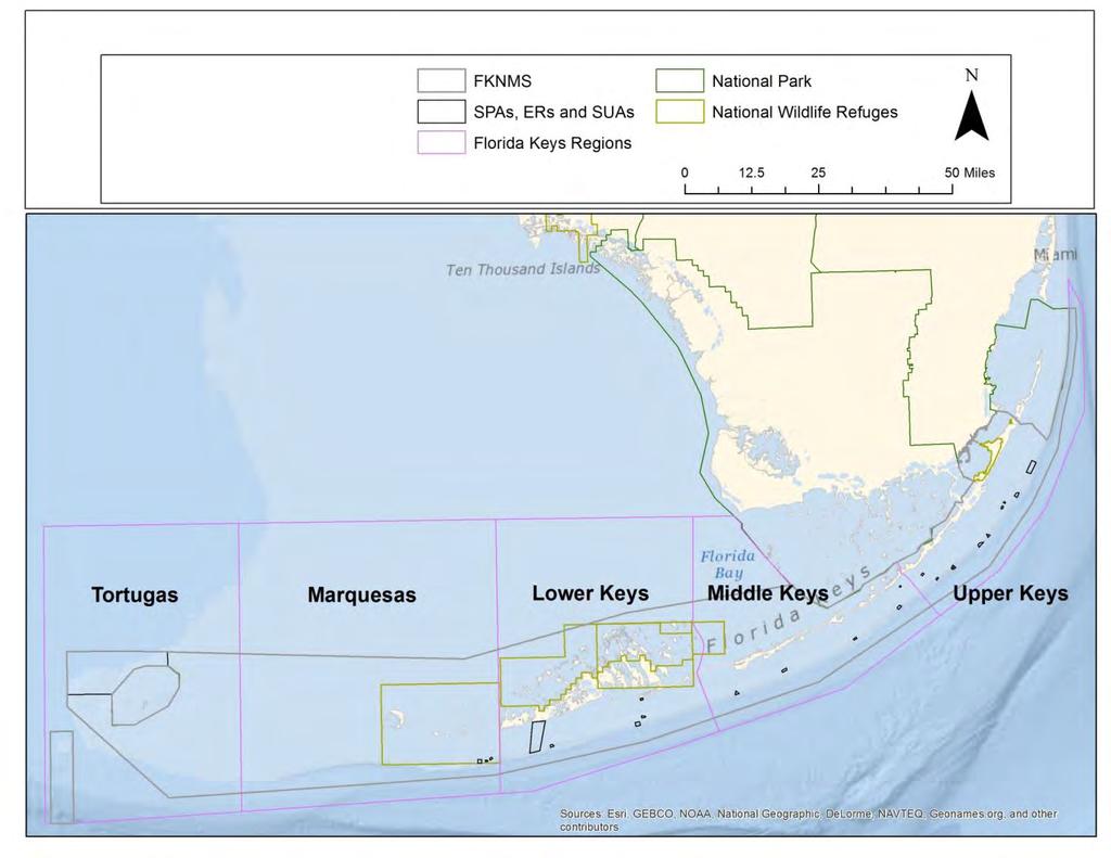
2 Where are locations of special places?
3
4
 Computer system that enables organization, queries, analyses of spatial data Uses: allows us to ask how much and")
5 Spatial Data and GIS Spatial Data Geographically referenced information Points: GPS coordinates Lines: Boat track Polygons: Sanctuary border Rasters: Aerial Imagery Geographic Information System (GIS) Computer system that enables organization, queries, analyses of spatial data Uses: allows us to ask how much and where
6 How much area is currently within zones? Management Zone Area (km 2 ) SPAs, SUAs 10 NMFS & Pennekamp Lobster management areas 26 Remaining FKNMS 1373 Resource Total 1409
7 Natural resources
8 Terminology Abundance = counts Density = count per unit area (e.g. m 2, nm 2 ) Species richness = number of different species


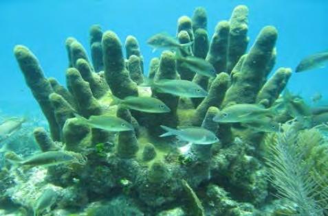
9 Datasets: Natural Resources Metrics Habitat Habitat types Turtle grass density High relief reefs Resilient reefs Coral ESA species Stony coral Soft coral Fish Fish Fish aggregations Fauna Conch Photos courtesy of NOAA photo library

10 Habitat Habitat

11 How are habitats distributed?
 NMFS & Pennekamp lobster management areas Remaining FKNMS, oceanside SPAS, Habitats SUAs Continuous reefs 3")
12 How are habitats distributed? Area (Km 2 ) NMFS & Pennekamp lobster management areas Remaining FKNMS, oceanside SPAS, Habitats SUAs Continuous reefs Patch reefs Hardbottom Sand Seagrass Unmapped


13 Where are locations of high relief reefs? Data source NMFS diver surveys Metric High relief reef
14 Where are locations of resilient reefs? Data source R. Van Woesik (FIT) analysis of Florida Reef Resilience Program coral surveys, Study Methods Spatial data selected for high coral colony density, relatively low observations of disease and bleaching
15 Where are locations of resilient reefs? Management Zone Area (km 2 ) SPAs, SUAs 0.02 NMFS & Pennekamp lobster management areas 0.10 Remaining FKNMS, oceanside 0.42 Resource Total 0.54
16 Species level information
, FWC NOAA NMFS Protected Resources & FWC ESA monitoring Species Currently listed as Threatened, ESA: elkhorn (Acropora palmata), staghorn (Acropora cervicornis)")
, star (M.")
17 Coral current and candidate ESA species Data sources Nova Southeastern University (SCREAM) Florida Reef Resilience Program (FRRP) Coral Reef Ecosystem Monitoring Program (CREMP), FWC NOAA NMFS Protected Resources & FWC ESA monitoring Species Currently listed as Threatened, ESA: elkhorn (Acropora palmata), staghorn (Acropora cervicornis) Currently listed as Threatened, State of FL: pillar (Dendrogyra cylindrus) Candidate Endangered, ESA: elkhorn, staghorn, pillar, boulder star (Montastraea annularis), mountainous star (M. faveolata), star (M. franksii) Candidate Threatened, ESA: sheet coral (Agaricia lamarcki), elliptical star coral (Dichocoenia stokesii) Metrics presence/absence
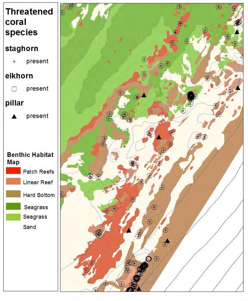
18 Threatened Coral Species

19 What proportions of sites with ESA coral species are present in current zones?

20 What proportion of sites with Threatened Pillar corals are present in current zones? FWC photo Threatened status State of FL; ESA candidate Endangered species Photo credit: FWC Photo credit: FWC 81 known sites with pillar coral present in the Florida Coral Reef Tract. 52 of these are in the Upper Keys Region. Source: FWC


21 What proportion of Threatened Pillar corals are present in current zones? Management Zone Locations (#) SPAs, SUAs 13 NMFS & Pennekamp lobster management areas 10 Remaining FKNMS, oceanside 29 Resource Total 52


22 Fish Aggregations Data sources NOAA & FWC Photo credit: C. Parsons Study Methods FSA locations for snappers and groupers collected from interviews with fishers, reports and field surveys from Key Largo to Marquesas and Dry Tortugas Metrics Fish Aggregations Single species, multi-species Present, probable, potential, reported

23 Where are locations of known fish aggregations? Cubera snapper Black grouper Mutton snapper, Black grouper, Yellowtail snapper yellowtail snapper
24 Coral reef community

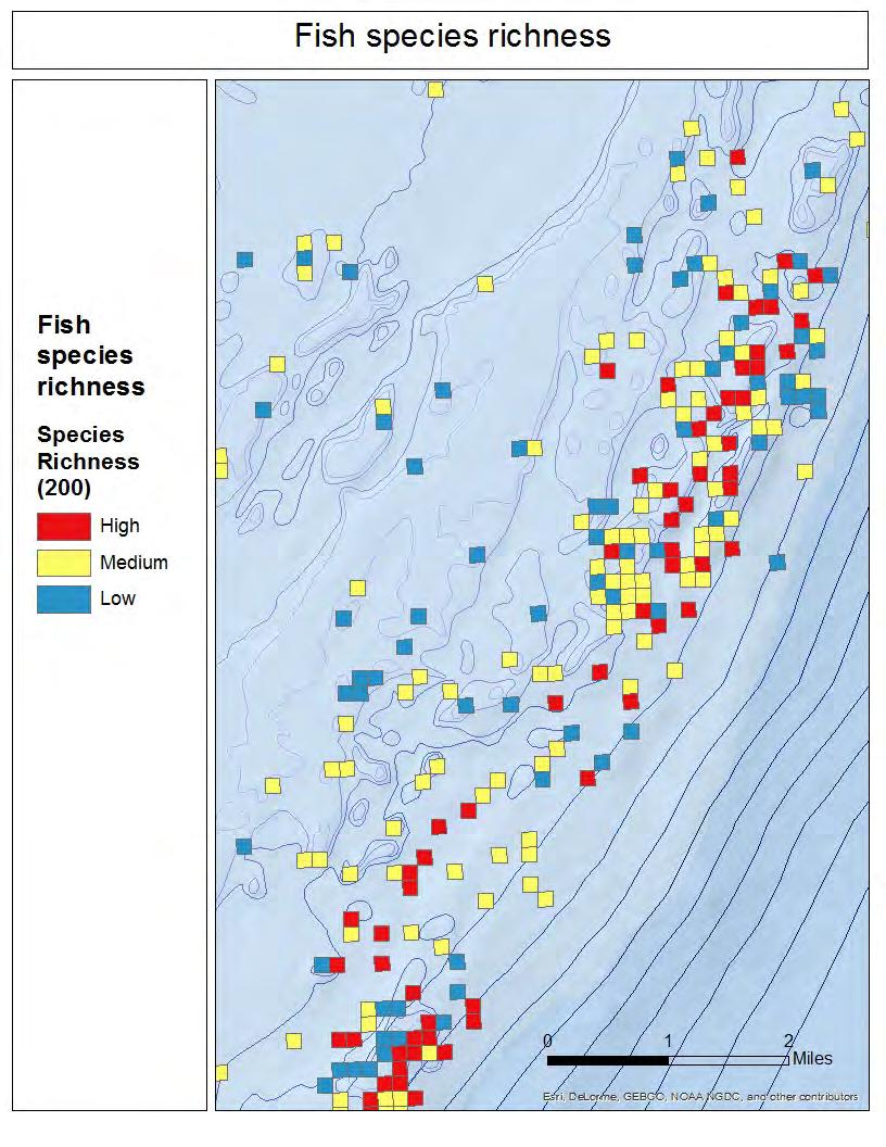
25 Reef fish visual census Data sources NOAA NMFS and partners including University of Miami, FWC Study Methods Diver-based stationary surveys on hardbottom reef Metrics Fish abundance Fish species richness Grouper-snapper complex abundance Nassau-Goliath grouper abundance Marine life fishery fish species abundance Top 10 marine life fishery fish species abundance Parrotfish abundance Barracuda abundance Permit abundance Photo courtesy of FKNMS
, FWC Metrics Stony coral Benthic cover (%) Density Species richness Soft Coral (Octocoral) Density Species richness Photo courtesy")
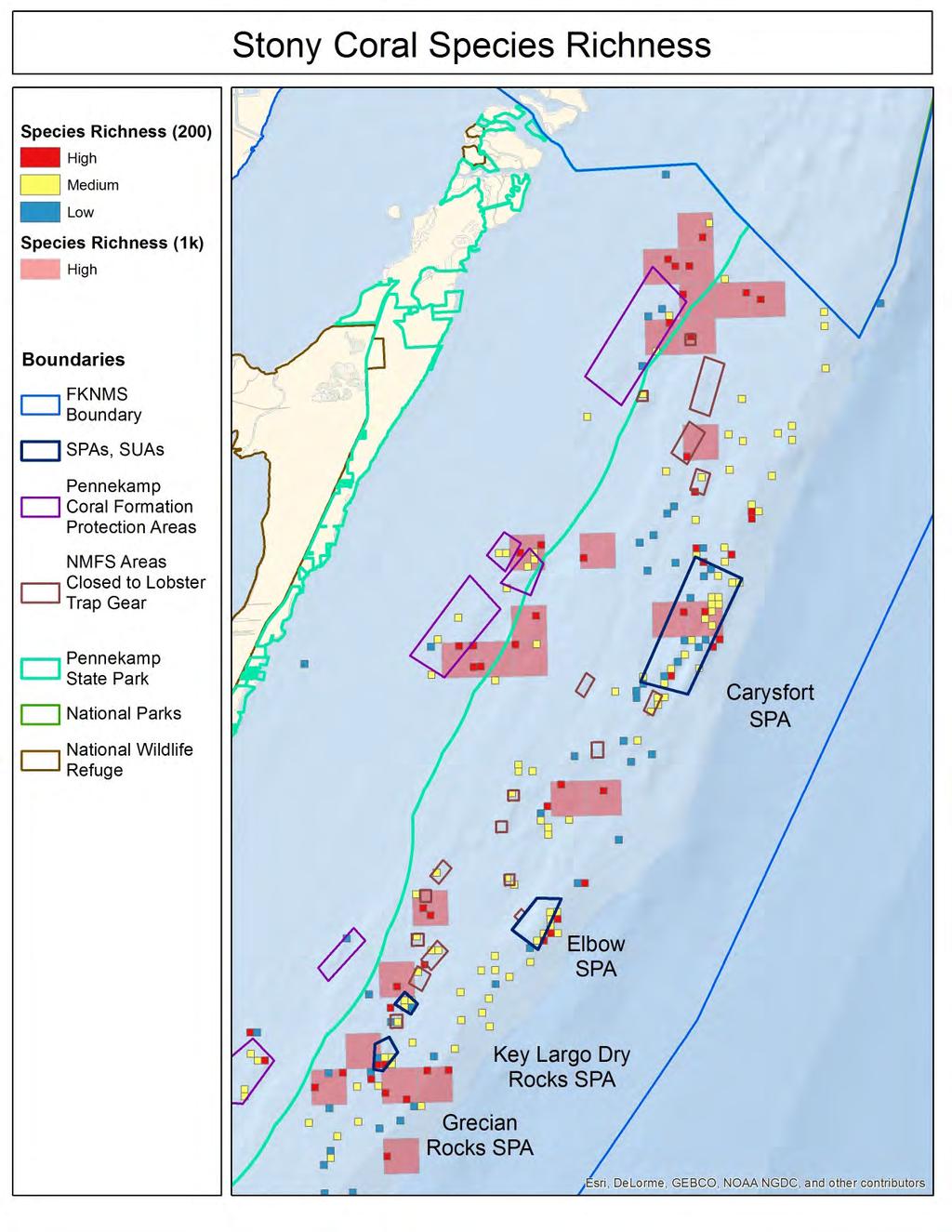
26 Coral Data sources Nova Southeastern University (SCREAM) Florida Reef Resilience Program (FRRP) Coral Reef Ecosystem Monitoring Program (CREMP), FWC Metrics Stony coral Benthic cover (%) Density Species richness Soft Coral (Octocoral) Density Species richness Photo courtesy of TNC

27 GIS Overview From field sampling to spatial data grid cell Larger grid cell point
28 How can we tell what areas are good? Rank survey site relative to other sites in upper Keys High % Top 25% Middle Medium % Bottom 25% Low >0 24 %


29 Fish Metrics Fish abundance: How many fish? Fish diversity: How many species of fish? Photo credit: FWC Photo credit: NOAA
30 Where are locations of high fish species richness?
31
32
33
34
35 Human Use


36 Datasets Human use Commercial Fishing Distribution of Commercial Fishers Distribution of Commercial Fishing Landings Recreational Fishing Distribution of Recreational and Charter Fishing Vessels Diving Activity Distribution of Dive Boats Distribution of Recreational Divers Marine Debris Vessel Groundings Photos courtesy of NOAA photo library and FKNMS

37 Commercial Fishing Data source Manoj Shivlani et al (2008). Knowledge Attitudes and Perceptions of Management Strategies and Regulations of the Florida Keys National Marine Sanctuary by Commercial Fishers, Dive Operators, and Environmental Group Members: A Baseline Characterization and 10-year Comparison. Metrics Density of Commercial Fishers per 1 nautical mile-squared ( ): Relative Distribution of Commercial Fishing Landings ( ) Spiny Lobster, Stone Crab, Reef Fish (Snapper/Grouper), King Mackerel, Spanish Mackerel, Other Pelagics (Cobia, Dolphin, Wahoo), Bait Fish, Shrimp and Total Landings Photo courtesy of NOAA Photo Library
38 Commercial Fishing Surveys Data Collection: 294 commercial fishers from the Florida Keys completed surveys about their fishing activity. Purpose: Survey questions gathered: General demographic information, Economic information, Fishery information including use patterns, Fishery Information: Effort (# Trips) Landings (Lbs) Cost per Trip Use Patterns Commercial fishers knowledge, attitudes, perceptions and beliefs regarding the FKNMS Time Period: Availability: Spatial information is available for 270 of the 294 fishers.
39 Surveys gathered spatial data on where each fisher fished:
40 Surveys gathered spatial data on where each fisher fished: Fisher B Fisher C Fisher A


41 Surveys gathered spatial data on where each fisher fished:
42 2
43

44 Upper Keys Spiny Lobster Fishers

45 Upper Keys All Commercial Fishers

46 Recreational and Charter Fishing Data source FWC. Aerial surveys of the Florida Keys reef tract. Metric Density of Recreational and Charter Fishing Vessels Observed per 1nm 2, May August Photo courtesy of NOAA Photo Library

47 Aerial Surveys Data Collection: During flyovers of the reef tract, surveyors counted the number of vessels at a given coordinate location, and documented the types of activities people were engaged in. Purpose: To quantify fishing pressure on historically known mutton snapper spawning aggregation sites, and locate other areas experiencing elevated fishing pressure. Time Period: Day before, day of, and day after full moon cycles in May August of 2010, 2011 and Photo courtesy of NOAA Photo Library


48 Aerial surveys took place over the Florida Keys reef tract, extending from Carysfort Lighthouse to Western Dry Rocks
49 Upper Keys Recreational and Charter Fishing Boats (1 nautical mile 2 )

50 Diving Activity Data sources -FWC. Aerial surveys of the Florida Keys reef tract. -Manoj Shivlani et al (2008). Knowledge Attitudes and Perceptions of Management Strategies and Regulations of the Florida Keys National Marine Sanctuary by Commercial Fishers, Dive Operators, and Environmental Group Members: A Baseline Characterization and 10-year Comparison. Metrics Dive Boats with Dive Flags, May August Density of Divers on Commercial Dive Boats per 1 nautical mile 2, 2005
51 Aerial Surveys Dive Boats Data Collection: Aerial surveys were conducted by plane over the Florida Keys reef tract. Time Period: Surveys were conducted the day before, day of, and day after full moon cycles in May August of 2010, 2011 and Availability: Recreational diving vessels were observed at 151 of 1692 locations Photo courtesy of FWC

52 Upper Keys Dive Boat Locations
53 Dive Operator Surveys Data Collection: 69 commercial dive operators were surveyed in the Keys about their diving activity in Purpose: Survey questions gathered: General demographic information, Economic information, Dive operator trip information, Commercial dive operators knowledge, attitudes, perceptions and beliefs regarding the FKNMS Trip Information: Total Trips (Annually) Number of Divers Dive Site Locations Time Period: 2005 Availability: Spatial information is available for 56 of the 69 commercial dive operators. Photo courtesy of NOAA Photo Library
54 Upper Keys Number of Divers
 Metric Marine Debris")

55 Marine Debris Marine Debris Data sources NOVA Southeastern University (SCREAM) Metric Marine Debris Density per 200 meters 2, Photos courtesy of NOAA Photo Library and Florida Keys National Marine Sanctuary

56 Marine Debris Data Collection: Researchers conducted surveys of marine debris during their assessments of corals, sponges and other marine life. Purpose: To document the type, distribution, weight and length of several types of marine debris Time Period: , 2008, and Availability: 813 records for marine debris include the following debris types: hook-and-line angling gear, lobster/crab trap debris, and other debris (glass, plastics, metals, etc). Source: Marine Debris in Reef Habitats, FKNMS Publication


57 Impacts Marine Debris Management Zone Area (km 2 ) SPAs, SUAs 3.70 NMFS and Pennekamp lobster management areas 4.38 Remaining FKNMS, oceanside Total % 11% 79% SPAs, RAs Lobster Management Areas Remaining unmanaged Areas


58 Vessel Groundings Data source Florida Keys National Marine Sanctuary Metric Distribution of Reported Vessel Groundings, Photos courtesy of NOAA Photo Library
59 Vessel Groundings Data Collection: Where possible, the coordinates, habitat type, vessel length and vessel type are recorded for each vessel grounding, among other information. Purpose: To track groundings in order to assess fines and recover the cost of damages from responsible parties. Time Period: Spatial information (records with lat/long coordinates) is available for records between January 2000 and April Source: Marine Debris in Reef Habitats, FKNMS Publication

60 Impacts Vessel Groundings Management Zone Groundings (#) SPAs, SUAs 47 NMFS and Pennekamp lobster management areas 7 Remaining FKNMS, oceanside 885 Total 939 5% 1% 94% SPAs, Ras Lobster Management Areas Remaining unmanaged Areas

61 Thank You! Photo courtesy of FKNMS
Improving fishermen awareness to reduce the presence of lobster traps in MPAs of the Florida Keys. Gabrielle Renchen & Tom Matthews
 Improving fishermen awareness to reduce the presence of lobster traps in MPAs of the Florida Keys Spiny Lobster Advisory Panel Meeting Key Largo, FL April 25, 2016 Gabrielle Renchen & Tom Matthews Florida
Florida Fish and Wildlife Conservation Commission (FWC)
") Florida Fish and Wildlife Conservation Commission (FWC) Mason Smith Florida Fish and Wildlife Conservation Commission Division of Marine Fisheries Management Version 1 FWC Mission To manage fish and wildlife
Florida Fish and Wildlife Conservation Commission (FWC) Mason Smith Florida Fish and Wildlife Conservation Commission Division of Marine Fisheries Management Version 1 FWC Mission To manage fish and wildlife
Effective multi-agency collaboration improves spatial monitoring and planning in the Florida Keys
 Effective multi-agency collaboration improves spatial monitoring and planning in the Florida Keys Jim Bohnsack Southeast Fisheries Science Center NOAA Fisheries Service Miami, FL 1 The Managed Florida
VII. Marine debris distribution
 2008 Quick Look Report: Miller et al. VII. Marine debris distribution Background Fishing constitutes one of the most significant threats to marine biodiversity and ecosystem function, documented by a growing
Geomorphology of grouper and snapper spawning aggregation sites in the Upper Florida Keys, USA
 Geomorphology of grouper and snapper spawning aggregation sites in the Upper Florida Keys, USA Art Gleason, Pamela Reid Division of Marine Geology and Geophysics University of Miami / Rosenstiel School
Florida Keys Population Abundance Estimates for Nine Coral Species Proposed for Listing Under the U.S. Endangered Species Act
 Florida Keys Population Abundance Estimates for Nine Coral Species Proposed for Listing Under the U.S. Endangered Species Act April 2013 Steven L. Miller, William F. Precht, Leanne M. Rutten and Mark Chiappone
DESCRIPTION OF REEF FISH SPAWNING AGGREGATIONS AT MONA ISLAND PUERTO RICO
 DESCRIPTION OF REEF FISH SPAWNING AGGREGATIONS AT MONA ISLAND PUERTO RICO Michelle Schärer, Michael Nemeth, Alfonso Aguilar, Richard Appeldoorn Department of Marine Sciences, University of Puerto Rico,
APPENDIX N. CORALS LISTING
 APPENDI N. CORALS LISTING MUNITIONS RESPONSE SITES MRS 02 AND MRS 07 PHASE 2 UNDERWATER RI/FS CULEBRA ISLAND SITE, PUERTO RICO APPENDI N. CORALS LISTING This appendix contains a copy of the NOAA Fisheries
ESSENTIAL FISH HABITAT HABITAT AREAS OF PARTICULAR CONCERN (EFH-HAPC) AND CORAL HABITAT AREAS OF PARTICULAR CONCERN (C-HAPC)
 AND CORAL HABITAT AREAS OF PARTICULAR CONCERN (C-HAPC)") ESSENTIAL FISH HABITAT HABITAT AREAS OF PARTICULAR CONCERN () AND CORAL HABITAT AREAS OF PARTICULAR CONCERN (C-HAPC) Shrimp Sargassum All coastal inlets, all statedesignated habitats of particular importance
ESSENTIAL FISH HABITAT HABITAT AREAS OF PARTICULAR CONCERN () AND CORAL HABITAT AREAS OF PARTICULAR CONCERN (C-HAPC) Shrimp Sargassum All coastal inlets, all statedesignated habitats of particular importance
VIII. Marine Debris. Background
 VIII. Marine Debris Background Fishing constitutes one of the most significant threats to marine biodiversity and ecosystem function, as evidenced by a significant body of information on the numerous impacts
Florida Keys National Marine Sanctuary
 Florida Keys National Marine Sanctuary Review of the Marine Zones and Regulations [insert your name here] [insert your email here] Florida Keys National Marine Sanctuary 2900 nm 2 / 10,000 km 2 Jurisdiction
Cluster Analysis for the Puerto Rico Island Region NOAA Fisheries Southeast Regional Office St. Petersburg, FL March 7, 2016 SERO-LAPP
 Cluster Analysis for the Puerto Rico Island Region NOAA Fisheries Southeast Regional Office St. Petersburg, FL March 7, 2016 SERO-LAPP-2016-03 Introduction The U.S. Caribbean is composed of the Commonwealth
Modeling effects of fishing closures in the Western Florida Shelf
 Modeling effects of fishing closures in the Western Florida Shelf David J. Die and Steven Saul* University of Miami * Currently SEFSC/NMFS/NOAA Outline Effects of fishing closures DWH Fishing closures
Management Area/SPA (FKNMS East of Ocean Reef (circled, aka Turtle Rocks) Existing Management Area: SPA is the largest (1.5 nm2)
 Existing Management Area: SPA is the largest (1.5 nm2)") Turtle Reef, Pennekamp (East Ocean Reef) Mid-Channel patch reef - State Waters Patch Reef, Pavement, Seagrass, Acroporids: staghorn, elkhorn FPS/John Pennekamp State Park Existing Management Area/Lobster
Turtle Reef, Pennekamp (East Ocean Reef) Mid-Channel patch reef - State Waters Patch Reef, Pavement, Seagrass, Acroporids: staghorn, elkhorn FPS/John Pennekamp State Park Existing Management Area/Lobster
Working Group Meeting Summary
 Florida Keys National Marine Sanctuary Marine Zoning & Regulatory Review Ecosystem Protection: Ecological Reserves / Preservation Areas and Wildlife Protection July 8 & 9, 2014 Working Group Meeting Summary
Goliath Grouper Public Workshops August and October, 2017
 Goliath Grouper Public Workshops August and October, 2017 Florida Fish and Wildlife Conservation Commission Division of Marine Fisheries Management and Fish and Wildlife Research Institute Version 1 1
TRACKING LIFE ON THE REEF Monitoring Benthic Communities in FKNMS No-Take Management Zones
 TRACKING LIFE ON THE REEF Monitoring Benthic Communities in FKNMS No-Take Management Zones Steven Miller 1, Mark Chiappone 1, Leanne Rutten 1 Jerry Ault 2, Steve Smith 2 1 Nova Southeastern University
Abundance, Distribution and Condition of Benthic Coral Reef Organisms in the Upper Florida Keys National Marine Sanctuary
 Abundance, Distribution and Condition of Benthic Coral Reef Organisms in the Upper Florida Keys National Marine Sanctuary 2010 Quick Look Report and Data Summary November 2010 Steven L. Miller, Mark Chiappone
Fish Aggregations in the Florida Keys
 Fish Aggregations in the Florida Keys Observations of Mutton Snapper on Riley s Hump Date and Station Numbers observed Moon phase 28 May 1 June 1999 1 fish in 3 of the 11 dives Full moon May 30* 31 July
Implementing the Dry Tortugas National Park. Research Natural Area Science Plan The 5-Year Report
 Florida Fish and Wildlife Conservation Commission National Park Service U.S. Department of the Interior South Florida Natural Resources Center Everglades and Dry Tortugas National Parks Implementing the
Fisheries of the Caribbean, Gulf of Mexico, and South Atlantic; Reef Fish Fishery of Puerto Rico and the U.S. Virgin Islands;
 This document is scheduled to be published in the Federal Register on 06/11/2018 and available online at https://federalregister.gov/d/2018-12420, and on FDsys.gov BILLING CODE: 3510-22-P DEPARTMENT OF
2011 Quick Look Report and Data Summary. December 2011
 Abundance, Distribution and Condition of Acropora Corals, Other Benthic Coral Reef Organisms, and Marine Debris in the Upper Florida Keys National Marine Sanctuary 2011 Quick Look Report and Data Summary
Go to Reference with Economic Statistics for US by Region and State. NOAA summary of fisheries of the US by state
 Go to Reference with Economic Statistics for US by Region and State Fisheries Economics of the United States 2014 Economics and Sociocultural Status and Trends Series U.S. Department of Commerce National
Overview: Fishery Management Council Process
 Overview: Fishery Management Council Process MREP Management Workshop Tampa, Florida September 30, 2014 Ben Hartig, Chairman South Atlantic Fishery Management Council Road Map for Presentation: Council
DRAFT Coral Reef Ecosystem Restoration Working Group Recommendations for Sanctuary Advisory Council Consideration DRAFT Habitat Type - Goals &
 Turtle Reef, FKNMS Offshore Patch Reef - Federal waters Coral Reef and Hardbottom, Aggregate Reef, Individual or Aggregated Patch Reef, Pavement, Seagrass, Acroporids: staghorn, elkhorn; condition data,
Towards Sustainable Multispecies Fisheries in the Florida Coral Reef Ecosystem
 Towards Sustainable Multispecies Fisheries in the Florida Coral Reef Ecosystem Jerald S. Ault University of Miami Rosenstiel School of Marine and Atmospheric Science Southern Florida coral reefs generated
WALTON COUNTY NRDA ARTIFICIAL REEF PROGRAM
 WALTON COUNTY NRDA ARTIFICIAL REEF PROGRAM Melinda Gates Lauren Floyd Kathryn Brown Beau Suthard, PG Franky Stankiewicz Walton County - Coastal Resource Liaison APTIM - Senior Marine Biologist APTIM -
Management Considerations for the Southeast Florida Coral Reef Ecosystem
 Management Considerations for the Southeast Florida Coral Reef Ecosystem Prepared by: Kurtis Gregg, Fishery Biologist ECS-Federal, Inc. on contract to NOAA Fisheries 400 North Congress Ave, Suite 120 West
Determining coral reef impacts associated with boat anchoring and user activity
 Determining coral reef impacts associated with boat anchoring and user activity Protect Our Reefs Grant Interim Report October 1, 2008 March 31, 2009 Donald C. Behringer 1, Thomas K. Frazer 1, Robert A.
Florida s Artificial Reef Monitoring Efforts
 Florida s Artificial Reef Monitoring Efforts Prepared by Keith Mille March 14, 2016 Dive assessment of the Oriskany Reef, October 2006. Photo by Keith Mille Florida Fish and Wildlife Conservation Commission
Project Webpage:
 Project Webpage: http://nature.ly/marinesatlanticbightera Coastal Data and Full Metadata: http://easterndivision.s3.amazonaws.com/marine/sab MA/SABMACoastalEcosystems.zip Coastal Chapter: http://easterndivision.s3.amazonaws.com/marine/sab
Marine Debris Along the Florida Keys Reef Tract- Mapping, Analysis and Perception Study
 University of Miami Scholarly Repository Open Access Theses Electronic Theses and Dissertations 2012-05-01 Marine Debris Along the Florida Keys Reef Tract- Mapping, Analysis and Perception Study Mallory
Goliath grouper management stakeholder project. Kai Lorenzen, Jessica Sutt, Joy Hazell, Bryan Fluech, Martha Monroe University of Florida
 Goliath grouper management stakeholder project Kai Lorenzen, Jessica Sutt, Joy Hazell, Bryan Fluech, Martha Monroe University of Florida The Management Challenge Divergent stakeholder views and high scientific
This presentation is a review and discussion of the biology, research, and management status of goliath grouper. The presentation will also describe
 This presentation is a review and discussion of the biology, research, and management status of goliath grouper. The presentation will also describe a stakeholder survey conducted by the University of
BERMUDA GOVERNMENT Ministry of Health, Seniors and Environment Department of Environmental Protection
 BERMUDA GOVERNMENT Ministry of Health, Seniors and Environment Department of Environmental Protection Mailing Address: Botanical Gardens Phone: 441-236-4201 P.O. Box HM 834 169 South Road Fax: 441-236-7582
Evolution of Deepwater Coral Protection in the Southeast U.S
 Evolution of Deepwater Coral Protection in the Southeast U.S Tina Udouj, Florida Fish and Wildlife Conservation Commission Roger Pugliese, South Atlantic Fishery Management Council Overview Deepwater Corals
Spawning Aggregation Evaluation. Utila January February 2009
 Spawning Aggregation Evaluation Utila January February 2009 Location Selection Selection considered fishermen and logistics Location 1: Joshua Swash Location 2: The Elbow The Elbow cancelled after January
SOUTH ATLANTIC FISHERY MANAGEMENT COUNCIL
 1 SOUTH ATLANTIC FISHERY MANAGEMENT COUNCIL ONE SOUTHPARK CIRCLE, SUITE 306 CHARLESTON, SOUTH CAROLINA 29407-4699 TEL 843/571-4366 or FAX 843/769-4520 Toll Free 1-866/SAFMC-10 E-mail: safmc@safmc.net Web
Domain (island) wide estimates of mutton snapper (Lutjanus analis) abundance for three US Caribbean Islands based on habitat-derived densities
 wide estimates of mutton snapper (Lutjanus analis) abundance for three US Caribbean Islands based on habitat-derived densities") Domain (island) wide estimates of mutton snapper (Lutjanus analis) abundance for three US Caribbean Islands based on habitat-derived densities SEDAR REPORT # SEDAR14-AW2 Prepared May 2007 by Christopher
Domain (island) wide estimates of mutton snapper (Lutjanus analis) abundance for three US Caribbean Islands based on habitat-derived densities SEDAR REPORT # SEDAR14-AW2 Prepared May 2007 by Christopher
Fisheries in the. US Virgin Islands. Jed Brown Acting Director & Chief of Fisheries USVI Division of Fish and Wildlife St. Croix, US Virgin Islands
 Fisheries in the US Virgin Islands Jed Brown Acting Director & Chief of Fisheries USVI Division of Fish and Wildlife St. Croix, US Virgin Islands US Virgin Islands Territorial waters Shoreline-3 miles
South Atlantic Council Issues
 South Atlantic Council Issues Review and Discussion February 8, 2018 Florida Fish and Wildlife Conservation Commission Version 2 This is a review and discussion of actions from the South Atlantic Fishery
Focus on New Sites for Caves and Reefs Issues Identified. Dr. Leyla Knittweis-Mifsud Department of Biology, Faculty of Science University of Malta
 Focus on New Sites for Caves and Reefs Issues Identified Dr. Leyla Knittweis-Mifsud Department of Biology, Faculty of Science University of Malta Presentation Overview Areas of conservation potential within
Case Study 3. Case Study 3: Cebu Island, Philippines MPA Network 10
 Case studies of mpa networks Case Study 3: Cebu Island, Philippines MPA Network 10 Location and background Cebu Island in the Philippines lies in the center of the Visayan Islands, known as an area high
Essential Fish Habitat: An overview of the consultation requirement for the American Association of Port Authorities
 Essential Fish Habitat: An overview of the consultation requirement for the American Association of Port Authorities National Marine Fisheries Service, Southeast Regional Office Habitat Conservation Division,
SOUTH ATLANTIC FISHERY MANAGEMENT COUNCIL ADVISORY PANEL SELECTION QUESTIONNAIRE CITY STATE ZIP. TELEPHONE (*Required) FAX
 FAX") SOUTH ATLANTIC FISHERY MANAGEMENT COUNCIL 4055 Faber Place Drive, Suite 201, North Charleston SC 29405 Call: (843) 571-4366 Toll-Free: (866) SAFMC-10 Fax: (843) 769-4520 Connect: www.safmc.net Dr. Michelle
SOUTH ATLANTIC FISHERY MANAGEMENT COUNCIL 4055 Faber Place Drive, Suite 201, North Charleston SC 29405 Call: (843) 571-4366 Toll-Free: (866) SAFMC-10 Fax: (843) 769-4520 Connect: www.safmc.net Dr. Michelle
CURRENT AND FUTURE SUSTAINABLE FISHERIES ACTIONS AND ACTIVITIES
 CURRENT AND FUTURE SUSTAINABLE FISHERIES ACTIONS AND ACTIVITIES Robert K. Mahood, Executive Director South Atlantic Fishery Management Council 4055 Faber Place Drive, Suite 201 North Charleston, South
To Fish or Not to Fish? A role-playing activity based on the Marine Reserves process at the Channel Islands National Marine Sanctuary
 To Fish or Not to Fish? A role-playing activity based on the Marine Reserves process at the Channel Islands National Marine Sanctuary Introduction This role playing activity is designed to teach you about
Linking Science to Management: A Conference and Workshop on the Florida Keys Marine Ecosystem. Program Agenda
 Tuesday, October 19, 2010 5:00pm - 7:00pm 5:00pm - 6:30pm 6:30pm - 7:30pm 8:00pm - 10:00pm Wednesday, October 20, 2010 7:00am - 5:30pm 7:00am - 8:00am Program Agenda Registration Opens [Ballroom Foyer
Florida s Spiny Lobster Fishery
 Florida s Spiny Lobster Fishery 2011 Seafood Webinar Series Presenters Dr. Lisa Krimsky, Miami-Dade Sea Grant Extension Agent Bryan Fluech, Collier County Sea Grant Extension Agent Using Elluminate Hand
Coral Reef Monitoring Protocol for the Overseas Territory Environmental Project British Virgin Islands
 Coral Reef Monitoring Protocol for the Overseas Territory Environmental Project British Virgin Islands Prepared by: Shannon Gore Marine Biologist - Conservation & Fisheries Department Ministry of Natural
Coral Reef Activity Book
 Coral Reef Activity Book Coral Reefs for health, for wealth, for life Did you know... Coral reefs can be found in all tropical areas of the world. Corals can also be found in deep cold oceans. Most corals
Project Title: Fisheries Content Provider Gulf Fisheries Info (FINFO) - #127. Gulf & South Atlantic Fisheries Foundation, Inc.
 - #127. Gulf & South Atlantic Fisheries Foundation, Inc.") Project Title: Fisheries Content Provider Gulf Fisheries Info (FINFO) - #127 Grantee: Gulf & South Atlantic Fisheries Foundation, Inc. Amount of Award: $19,000 Award Period: October 3, 2013 - March 31,
Project Title: Fisheries Content Provider Gulf Fisheries Info (FINFO) - #127 Grantee: Gulf & South Atlantic Fisheries Foundation, Inc. Amount of Award: $19,000 Award Period: October 3, 2013 - March 31,
Working Group Meeting Summary
 Florida Keys National Marine Sanctuary Marine Zoning & Regulatory Review Ecosystem Protection: Ecological Reserves / Preservation Areas and Wildlife Protection March 25 & 26, 2014 Working Group Meeting
Proposed Terrestrial Critical Habitat for the Northwest Atlantic Loggerhead Sea Turtle Population. U.S. Fish and Wildlife Service
 Proposed Terrestrial Critical Habitat for the Northwest Atlantic Loggerhead Sea Turtle Population U.S. Fish and Wildlife Service History of Loggerhead Listing (joint responsibility USFWS and NOAA Fisheries)
Fishing for Energy Fund Project Summaries
 Fishing for Energy Fund Project Summaries Removal of 'ghost' blue crab pots from known hotspots in VA, College of William and Mary, Virginia Institute of Marine Science Virginia Fishing for Energy Fund
The Role of Research and Monitoring in Management of Living Marine Resources off the Southeast U.S. Coast Introduction
 The Role of Research and Monitoring in Management of Living Marine Resources off the Southeast U.S. Coast Marine Resources Research Institute Marine Resources Division, South Carolina Department of Natural
Updated landings information for the commercial fisheries in Puerto Rico with emphasis on silk and queen snapper and parrotfish fisheries
 Updated landings information for the commercial fisheries in Puerto Rico with emphasis on silk and queen snapper and parrotfish fisheries Nancie J. Cummings and Daniel Matos-Caraballo SEDAR 26-DW-03 Date
Determining Coral Reef Impacts Associated with Boat Anchoring and User Activity in Southeast Florida
 Determining Coral Reef Impacts Associated with Boat Anchoring and User Activity in Southeast Florida Southeast Florida Coral Reef Initiative Fishing, Diving, and Other Uses Local Action Strategy Project
U.S. Virgin Islands Commercial Fishery Data Collection Programs
 U.S. Virgin Islands Commercial Fishery Data Collection Programs Division of Fish and Wildlife, USVI Dept. of Planning and Natural Resources Marine Resource Education Program Meeting, May 23-25, 2017 Overview
Gulf of the Farallones National Marine Sanctuary Safe Harbor for Sea Turtles
 Gulf of the Farallones National Marine Sanctuary Safe Harbor for Sea Turtles Photos by Doug Perrine They re here now! Leatherbacks swim 6,000 miles from Indonesia to California to Feed on Jellyfish ~ August
PUBLIC HEARING GUIDE 7/27/12. Modifications to Federally-Permitted Seafood Dealer Reporting Requirements
 PUBLIC HEARING GUIDE 7/27/12 Modifications to Federally-Permitted Seafood Dealer Reporting Requirements Photos courtesy of: Louisiana Seafood, Kathy Hoak Table of Contents What is a Public Hearing? 1 How
Field Protocol for Monitoring Coral Reef Fisheries Resources in Belize
 Field Protocol for Monitoring Coral Reef Fisheries Resources in Belize Charles A. Acosta, PhD Wildlife Conservation Society Glover s Reef Marine Research Station P.O. Box 272 Dangriga, Belize and Department
Marine Management Strategy Frequently Asked Questions
 Marine Management Strategy Frequently Asked Questions Can I still go fishing at Rottnest? Yes Where will I be able to go fishing on Rottnest Island? Recreational fishing can occur at any location outside
St. Croix-Draft Actions and Alternatives.
 [Type the document title] St. Croix-Draft Actions and Alternatives. Scoping Meetings April 2014 Table of Contents List of Tables... 2 List of Figures... 2 Action 1. Identify Fishery Management Units (FMUs)
Modifications to Gulf Reef Fish and South Atlantic Snapper Grouper Fishery Management Plans
 Tab B, No. 11b 3/19/15 Modifications to Gulf Reef Fish and South Atlantic Snapper Grouper Fishery Management Plans Draft Joint Generic Amendment DECISION DOCUMENT For the Joint Council Committee on South
Marine Debris from Land to Sea: Holistic Characterization, Reduction and Education Efforts in New Hampshire
 Marine Debris from Land to Sea: Holistic Characterization, Reduction and Education Efforts in New Hampshire ABSTRACT Over time, the focus of marine debris research and work has shifted away from simply
Integrating basic and applied ecology using paired artificial natural reef systems.
 Integrating basic and applied ecology using paired artificial natural reef systems. Christopher D. Stallings 1, Kara R. Wall 1, Peter Simard 1, Jennifer E. Granneman 1, Kelly Kingon 2, and Christopher
no-take zone 1 of 5 Channel Islands National Marine Sanctuary, California
 This website would like to remind you: Your browser (Apple Safari 4) is out of date. Update your browser for more security, comfort and the best experience on this site. Encyclopedic Entry no-take zone
Ecological Processes and Coral Reef Recovery in the Florida Keys
 Final 2 October 26 Ecological Processes and Coral Reef Recovery in the Florida Keys Struan R. Smith (Bermuda Biological Station for Research, Inc., St. George s GE, Bermuda) Richard B. Aronson and Thaddeus
Peninsular Florida Landscape Conservation Cooperative. Priority Resources Marine/Estuarine
 Peninsular Florida Landscape Conservation Cooperative Priority Resources Marine/Estuarine Draft Priority Resources Sub Resources Salt Marsh Mangrove Coral Seagrass Selected Classification systems Cooperative
Following Information Compliments of Avadon Divers, Placencia Belize
 Following Information Compliments of Avadon Divers, Placencia Belize The Blue Hole & Lighthouse Reef Trips to this atoll are done only when there are good surface conditions as it is a 3-hour boat ride
Protect Our Reefs Grant Interim Report (October 1, 2008 March 31, 2009) Principal investigators: Donald C. Behringer and Mark J.
 Principal investigators: Donald C. Behringer and Mark J.") Investigating the role of the spotted spiny lobster (Panulirus guttatus) in the recovery of the long spined sea urchin (Diadema antillarum) on the coral reefs of the Florida Keys Protect Our Reefs Grant
Investigating the role of the spotted spiny lobster (Panulirus guttatus) in the recovery of the long spined sea urchin (Diadema antillarum) on the coral reefs of the Florida Keys Protect Our Reefs Grant
Gulf of Mexico Fishery Management Council; Public Meeting. AGENCY: National Marine Fisheries Service (NMFS), National Oceanic and
, National Oceanic and") This document is scheduled to be published in the Federal Register on 01/11/2018 and available online at https://federalregister.gov/d/2018-00375, and on FDsys.gov BILLING CODE 3510-22-P DEPARTMENT OF
This document is scheduled to be published in the Federal Register on 01/11/2018 and available online at https://federalregister.gov/d/2018-00375, and on FDsys.gov BILLING CODE 3510-22-P DEPARTMENT OF
Gulf of Mexico Fishery Management Council. Commercial Fishing Regulations for Gulf of Mexico Federal Waters
 Gulf of Mexico Fishery Management Council Protecting our marine resources Commercial Fishing Regulations for Gulf of Mexico Federal Waters November, 2005 For Species Managed by the Gulf of Mexico Fishery
East Central Florida Region Matt Culver, Brevard County James Gray, Indian River County Jim Oppenbourn, St. Lucie County Kathy Fitzpatrick, Martin
 James Gray, Indian River County January 14, 2015 East Central Florida Region Matt Culver, Brevard County James Gray, Indian River County Jim Oppenbourn, St. Lucie County Kathy Fitzpatrick, Martin County
Appendix Template for Submission of Scientific Information To Describe Ecologically or Biologically Significant Marine Areas
 Appendix Template for Submission of Scientific Information To Describe Ecologically or Biologically Significant Marine Areas Abstract (in less than 150 words) Coastal and marine areas: Africa Somalia has
Commercial Fisheries in the South Coast s Marine Protected Areas
 STATE OF THE CALIFORNIA SOUTH COAST SUPPLEMENTAL REPORT COMMERCIAL FISHERIES Researchers from the California Department of Fish and Wildlife (CDFW) used landings data from CDFW s Commercial Fisheries Information
Semi-Annual Progress Report for: June 1, November 30, 2004
 Combining a Partnership Among Researchers, Commercial Recreational, and Recreational-For-Hire Fishers With a Cooperative T~gging Program to Elucidate the Life History and Habit Utilization of Select Reef
What are the most recent changes to the Fisheries Regulations in The Bahamas?
 SPORT FISHING What are the most recent changes to the Fisheries Regulations in The Bahamas? Sharks are now protected in The Bahamas as a result of an amendment made in 2011. Sharks may only be taken under
UNDERWATER ARCHAEOLOGY Pickles Reef Florida Keys National Marine Sanctuary
 UNDERWATER ARCHAEOLOGY Pickles Reef Florida Keys National Marine Sanctuary MAHS Survey and Field School 2011 MAHS returned to Florida in June of 2011 to continue a survey of Pickles Reef begun in 2010.
Subtidal and intertidal restored reefs in North Carolina
 Subtidal and intertidal restored reefs in North Carolina Jonathan H. Grabowski 1, Sean P. Powers 2, Pete Peterson 3, and Hunter S. Lenihan 4 1 Gulf of Maine Research Institute/U. Maine-Darling Marine Center
What is Project Baseline?
 What is Project Baseline? A global network of highly skilled and organized SCUBA divers who are creating a lasting visual legacy of underwater conditions in oceans, lakes, rivers, springs, and caves all
Revised 5/6/10
 2009-10 Revised 5/6/10 Recreational Fishing Regulations for Gulf of Mexico Federal Waters This publication was prepared for general informational purposes in May 2009, and has no legal force or effect.
Barotrauma in Atlantic Coast Fisheries. Chip Collier March 2011
 Barotrauma in Atlantic Coast Fisheries Chip Collier March 2011 Atlantic Ecosystems Coastline 2,100 miles Two Large Marine Ecosystems Northern Southern Three Councils New England Mid Atlantic South Atlantic
Resort and Dive Operation Management, Marine Biology Support, Programmes and Training.
 Helen Sykes & Stuart Gow Mail: PO Box 2558 Government Buildings SUVA, Fiji Islands Tel: (679) 336 3625 or 359 2136 Email: resortsupport@connect.com.fj Resort and Dive Operation Management, Marine Biology
Nature Foundation Marine Park, Reef & Marine Research Assessments Post Hurricane Irma
 Nature Foundation Marine Park, Reef & Marine Research Assessments Post Hurricane Irma Melanie Meijer zu Schlochtern Project Officer Nature Foundation St Maarten 24 November 2017 - ongoing Hurricane Irma
Sherwood Forest Flag Expedition
 Sherwood Forest Flag Expedition May 10 th to 20 th 2005 Flag #53 Introduction: Since its inclusion in the nation s largest permanent marine reserve as part of the Florida Keys National Marine Sanctuary,
Coral Habitat Areas Considered for Management in the Gulf of Mexico
 Coral Habitat Areas Considered for Management in the Gulf of Mexico 05/2018 Leiopathes glaberrima with Eumunida picta Leiopathes sp. Lophelia reef Deep-sea corals Table of Contents What is a Public Hearing?...1
Socioeconomic Profile and Spatial Analysis of Fisheries in the three central California National Marine Sanctuaries
 Socioeconomic Profile and Spatial Analysis of Fisheries in the three central California National Marine Sanctuaries Overview and Assessment of CDFG Fisheries Data for use in the Joint Management Plan Review
Tortugas Ecological Reserve
 Strategy for Stewardship Tortugas Ecological Reserve U.S. Department of Commerce National Oceanic and Atmospheric Administration National Ocean Service Office of National Marine Sanctuaries Final Supplemental
NOAA Fisheries Service (NMFS) Update on North Atlantic Right Whale Recovery Actions
 Update on North Atlantic Right Whale Recovery Actions") NOAA Fisheries Service (NMFS) Update on North Atlantic Right Whale Recovery Actions Asaro, M.J. 1 1 National Marine Fisheries Service, Greater Atlantic Regional Fisheries Office, 55 Great Republic Dr,
NOAA Fisheries Service (NMFS) Update on North Atlantic Right Whale Recovery Actions Asaro, M.J. 1 1 National Marine Fisheries Service, Greater Atlantic Regional Fisheries Office, 55 Great Republic Dr,
Unless otherwise noted, images throughout the presentation are by FWC.
 This presentation provides an update on current programs in place to collect catch and effort data for Florida s saltwater recreational fisheries, including the Gulf Reef Fish Survey (GRFS) and potential
Overview of Florida s Cooperative East Coast Red Snapper Tagging Program, SEDAR41-DW10. Submitted: 1 August 2014
 Overview of Florida s Cooperative East Coast Red Snapper Tagging Program, 2011-2013 Russell B. Brodie, Justin J. Solomon, Richard Paperno, Theodore S. Switzer, Cameron B. Guenther, and Beverly Sauls SEDAR41-DW10
Coral Reefs N Q U. Visit for thousands of books and materials.
 Coral Reefs A Reading A Z Level N Leveled Book Word Count: 615 N Q U Written by Paula Schricker Visit www.readinga-z.com for thousands of books and materials. www.readinga-z.com Photo Credits: Front cover:
August 3, Prepared by Rob Cheshire 1 & Joe O Hop 2. Center for Coastal Fisheries and Habitat Research Beaufort, NC
 SEDAR 19-DW05 Evaluation of the 1960, 1965, and 1970 U.S. Fish and Wildlife Service salt-water angling survey data for use in the stock assessment of red grouper (Southeast US Atlantic) and black grouper
Reducing Risk of Whale Entanglements in Oregon Dungeness Crab Gear
 Session 3 Reducing Risk of Whale Entanglements in Oregon Dungeness Crab Gear CaseID: 20150703Mn NMFS MMHSRP Permit #: 18786 Overview West Coast Information Framing the problem Summary of West Coast large
Final Report, October 19, Socioeconomic characteristics of reef users
 Socioeconomic Study of Reefs in Southeast Florida - Executive Summary By Hazen and Sawyer in association with Florida State University and National Oceanic and Atmospheric Administration, October 19, 2001
The Operations and Economics of the For-Hire Fishing Fleets of the South Atlantic States and the Atlantic Coast of Florida
 The Operations and Economics of the For-Hire Fishing Fleets of the South Atlantic States and the Atlantic Coast of Florida Stephen M. Holland, Ph.D. Department of Tourism, Recreation & Sport Management
The Protection of Vulnerable Marine Ecosystems in the Northwest Atlantic: NAFO Processes and Regulations
 The Protection of Vulnerable Marine Ecosystems in the Northwest Atlantic: NAFO Processes and Regulations Dr. Ricardo Federizon Senior Fisheries Commission Coordinator Northwest Atlantic Fisheries Organization
Marine Recreational Information Program Transition to Improved Survey Designs
 Marine Recreational Information Program Transition to Improved Survey Designs David Gloeckner Southeast Fisheries Science Center Richard Cody Office of Science & Technology Improved Survey Designs Fishing