WDAA Maps Directions & Special Rules
|
|
|
- Samson Allison
- 6 years ago
- Views:
Transcription


1 WDAA Maps Directions & Special Rules
. Follow road down to the bottom of the lane.")
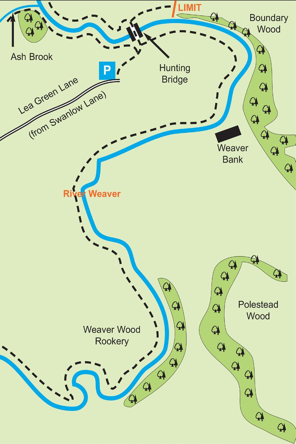
2 Upper Weaver Lea Green Lane Head towards Church Minshull on Swanlow Lane from Winsford. Pass over narrow bridge crossing Ash Brook and through an S bend. Turn next left into Lea Green Lane (you will see CCTV cameras mounted on a pole at the entrance). Follow road down to the bottom of the lane. There is no car park for this venue so please park your car at the side of the road taking care not to obstruct farmer s access to fields. Walk down to the end of the lane and turn left (downhill) and through the gate. Access to the other side of the river is via the Hunting Bridge (please remember to close both gates).
3
 there is also a small red letter box as you make the turn. Proceed down the lane for approximately 0.")
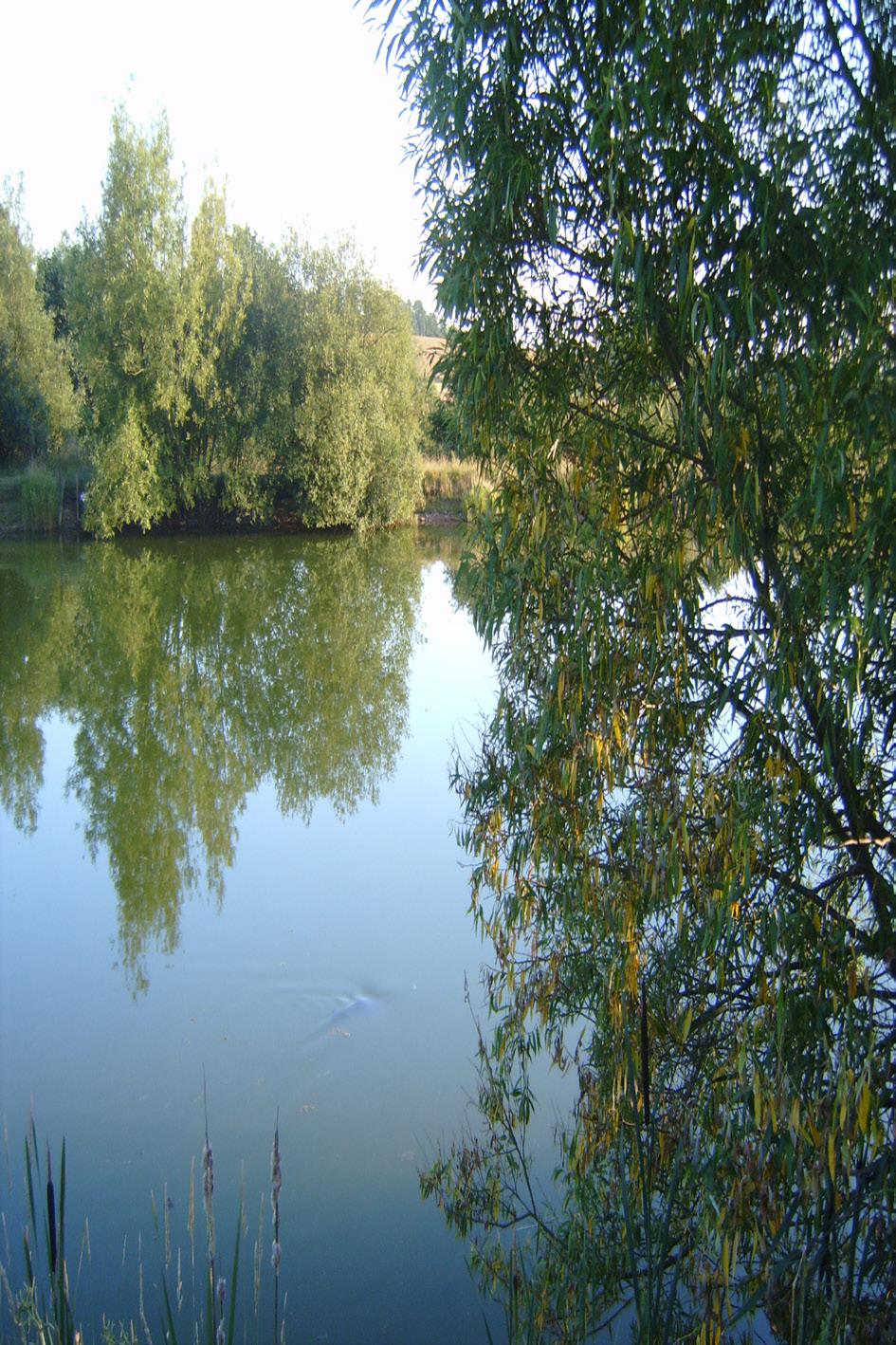
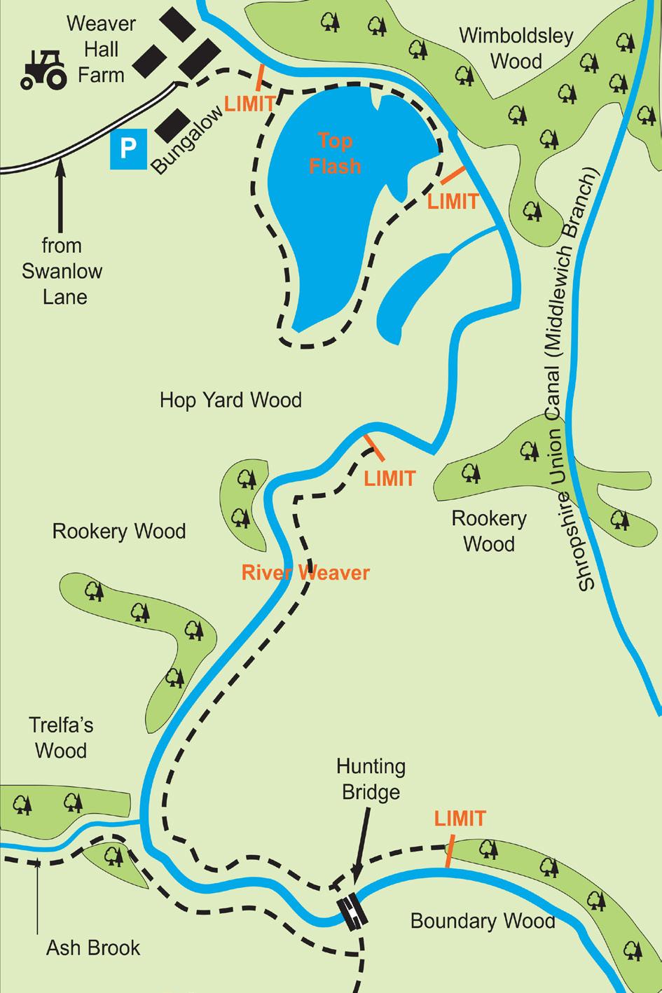
4 Top Flash Head towards Church Minshull on Swanlow Lane from Winsford. Turn left at a small sign for John Bownes Ltd and Bowland Tractors, (just before the Raven Pub) there is also a small red letter box as you make the turn. Proceed down the lane for approximately 0.6 mile. As you get to a fork in the road turn left over the cattle grid and continue on for approximately 0.4 mile and park to the right side of the bungalow as you look at it. Do not drive into the farm yard. Walk past the bungalow towards the farm and turn right over a cattle grid. Special Rules: (i) No fishing before 6.30am. Finishing time June to September 10pm and from October to March 7pm. (ii) National river closed season applies on this water. (iii) No member must pass the sign in the access road before 6.30am. (iv) Parking rules are displayed on both upper and lower car park notice boards. No more than 8 cars are allowed to park by the water. (v) Poolside parking ONLY allowed from June to September. From October to March parking ONLY allowed in the top car park. Night anglers must park their vehicles in the top car park at all times but may use the lower car-park to unload tackle. (vi) Do not drive down to the pool in wet conditions The owner does not want vehicles getting stuck. (vii) Three rods may be used between 1st October and 1st March. If you are fishing with three rods you MUST by law also purchase two EA rod licences.
5
 there is also a small red letter box as you make the turn. Proceed down the lane for approximately 0.")
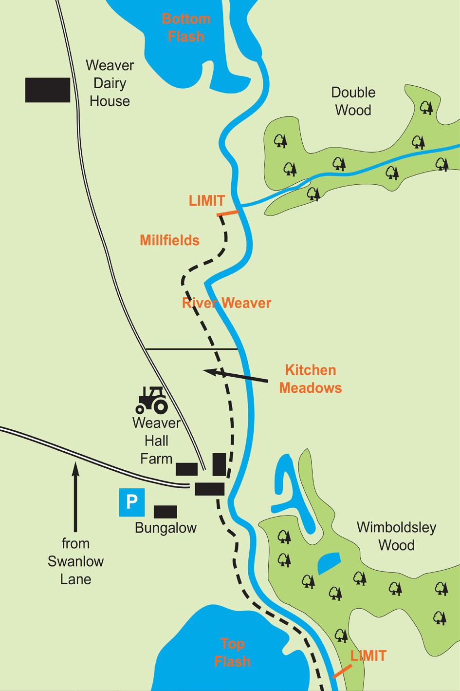
6 Upper Weaver to Bottom Flash Head towards Church Minshull on Swanlow Lane from Winsford. Turn left at a small sign for John Bownes Ltd and Bowland Tractors, (just before the Raven Pub) there is also a small red letter box as you make the turn. Proceed down the lane for approximately 0.6 mile. As you get to a fork in the road turn left over the cattle grid and continue on for approximately 0.4 mile and park to the right side of the bungalow as you look at it. Do not drive into the farm yard. Kitchen Meadow and Millfields Walk through farmyard and turn left at Weaver Hall, then take 1st access gate on right hand side to Kitchen Meadow and then on to Millfields. Anglers should note that the owners of these lengths do not accept any liability whatsoever for damage to property or injury to persons who may be angling or gaining access for angling, consequently all use of these facilities is at members own risk. Rear of Top Flash Access is the same as for Top Flash.
7

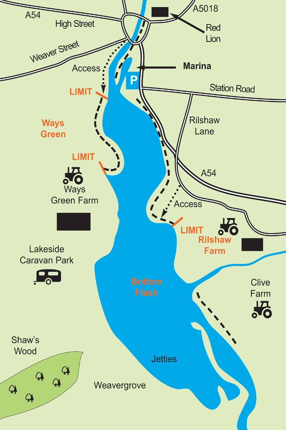
8 Rilshaw Meadows Access is from Rilshaw Lane (off Station Road) Ways Green Meadows Access is via the public footpath at the bottom of Weaver Street along riverbank on the opposite side of the river to the Marina car park and over the stile. Marina Access is from the Marina car park situated off the dual carriageway section of the A54.
9

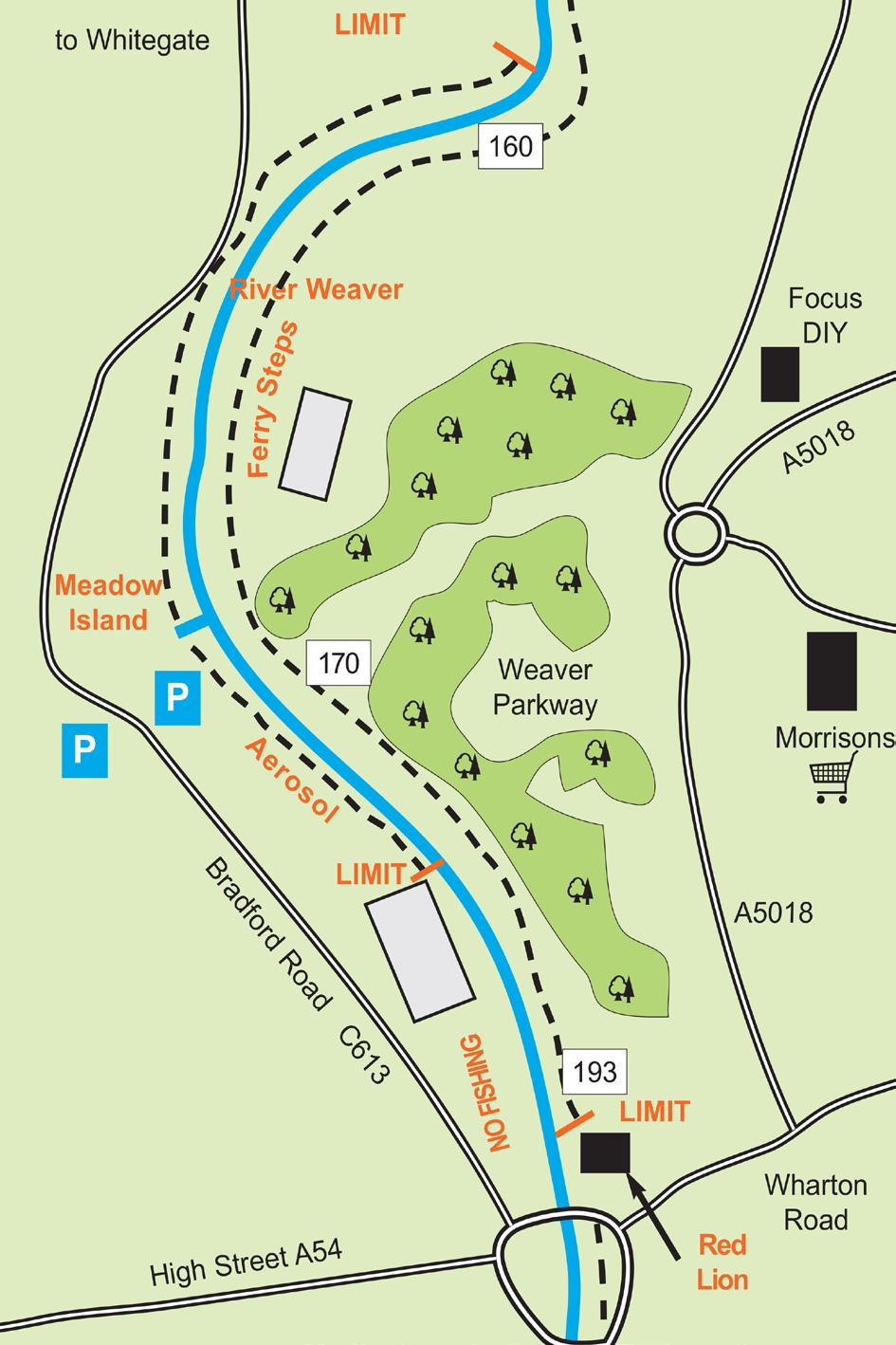
10 River Weaver Aerosol and Meadow Island Sections Follow signs for Whitegate from traffic island over the river in Winsford into Bradford Road. Shortly after Royal Mail offices you will see two car parks on either side of the road. Park in either and proceed down to river over stile. Red Lion Section Access is from the rear of the Red Lion pub along the Weaver Parkway paths. Ferry Steps Section Access is from the rear of the Red Lion pub and also from the Weaver Parkway paths from the Morrisons roundabout and Weaver Valley Road.
11

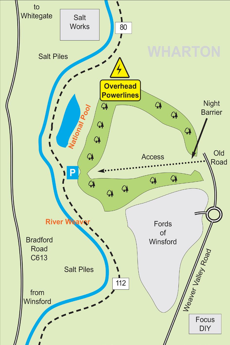
12 Lower Weaver/National Pool Follow signs for Northwich from traffic island over the river in Winsford to Morrisons roundabout. At this roundabout take the first exit and drive past Wickes DIY and Fords of Winsford. You will come to a gate on the left, for which you will need a key - see below*. You can then drive down to the car park on the river bank. * Details of how to obtain a key can be found on: If you don t have access to the internet, details can be obtained from the Ranger s Office at Weaver Valley Road, Winsford. When fishing please remember to close the gate behind you every time you pass through it.
13

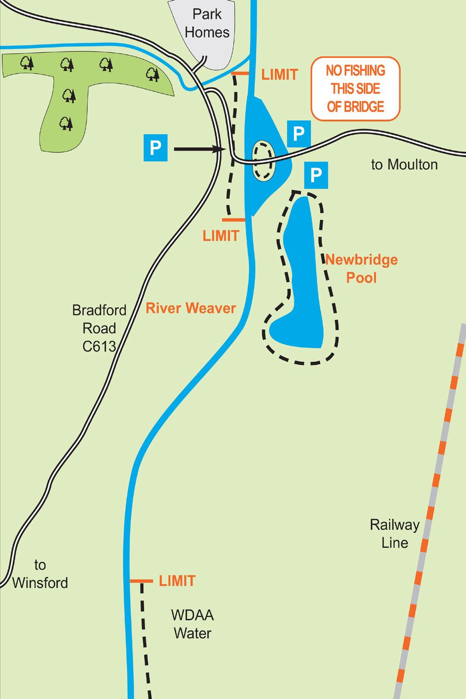
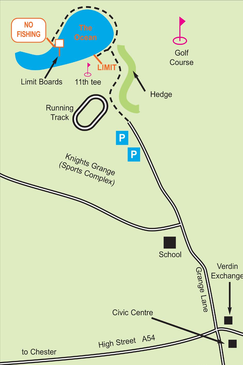
14 Newbridge & Newbridge Pool Follow signs for Whitegate from traffic island over the river in Winsford into Bradford Road. After Salt Works the road narrows and you will see signs for a narrow bridge. Just before this bridge turn right and follow road down to the river and over New Bridge. You can park on either side of the river. Special Rules (Newbridge Pool): (i) 12 months fishing from April 1st to May 31st for working party members only. (ii) Members only no day tickets allowed. (iii) Gate key is required for access - see below* (iv) No fires allowed. (v) No lights, except for baiting up. (vi) Offenders will be subject to Rule 13. * Details of how to obtain a key can be found on: Car Parking at Newbridge Pool Night anglers are allowed to park their cars inside the gate at Newbridge Pool provided there is sufficient room to do so, this is done in a safe manner and does not cause obstruction to others. Cars are ONLY allowed inside the gate from dusk until the following morning when they must be removed by hours. Cars MUST NOT be parked inside the gate throughout the day. Failure to adhere to these restrictions may result in disciplinary action being taken.
15

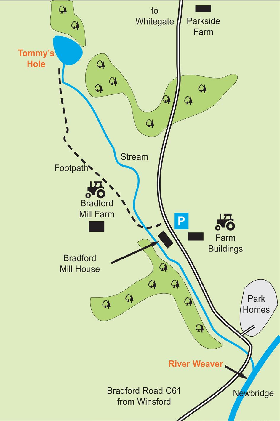
16 Tommy s Hole Follow signs for Whitegate from traffic island over the river in Winsford into Bradford Road. Continue over narrow bridge and through sharp left hand bend. You may park in the small car park on the right, opposite Bradford Mill House. From there follow the public footpath signs and cross the fields to the pool. 12 months fishing allowed on this water.
17
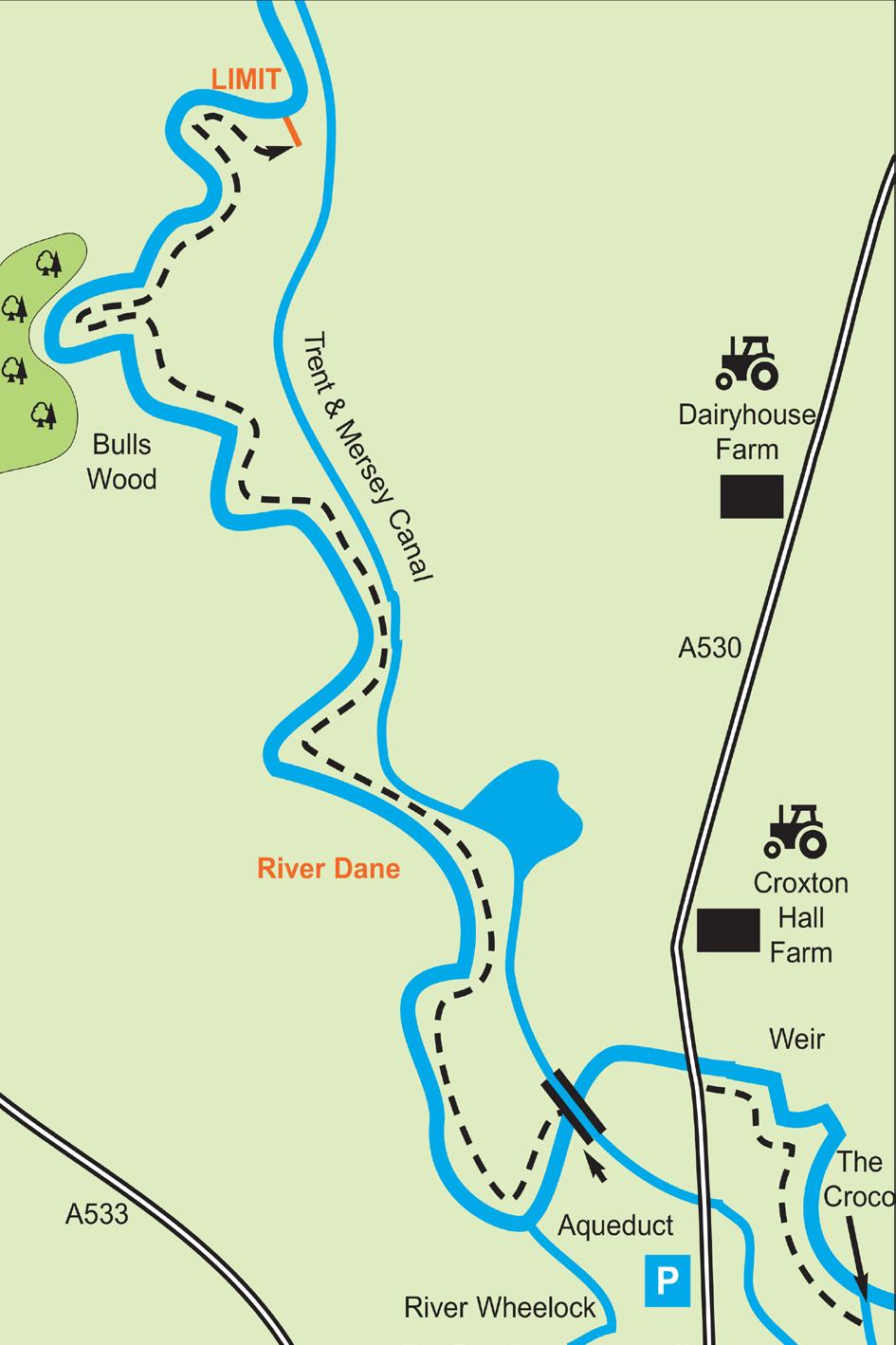
 A daily limit of 20 Anglers. (ii) 12 months angling allowed.")
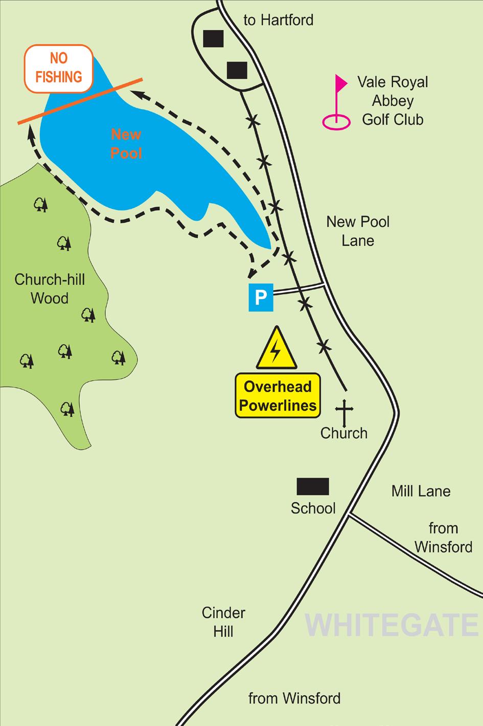
18 New Pool From Winsford, follow the signs for Whitegate. You will enter the village either via Mill Lane or Cinder Hill. From Mill Lane turn right into Newpool Lane. You will pass a church and go through a tight left hand bend. Turn left into the car park shortly after the bend. Special Rules: (i) A daily limit of 20 Anglers. (ii) 12 months angling allowed. (iii) No keep nets allowed for pleasure angling. (iv) Affiliated Clubs may book matches on the pool on Wednesdays and Thursdays. (v) The is no fishing at the far end of the lake. (vi) From 1st April to 31st May, working party members only. (vii) See the inside front cover of this permit for angling times. (vii) Gate key is required for access - see below* * Details of how to obtain a key can be found on:
19
 A daily limit of 6 Anglers. (ii) 12 months angling allowed. (iii) No keep nets allowed for pleasure angling. (iv) Fishing is from designated pegs only.")
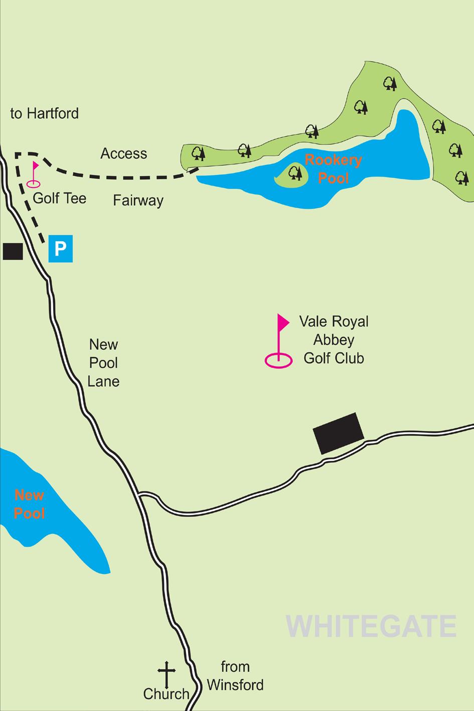
20 Rookery Pool The gated car park for the pool is found approximately a quarter of a mile past New Pool in the direction of Hartford on the right hand side. Special Rules: (i) A daily limit of 6 Anglers. (ii) 12 months angling allowed. (iii) No keep nets allowed for pleasure angling. (iv) Fishing is from designated pegs only. (v) From 1st April to 31st May, working party members only. (vi) The access route from the car park is around the 7th tee and follow the left hand fence line down to the pool. (vii) Due to the sensitivity of this water we ask that members pay particular attention to the rules regarding litter and fires (viii) Gate key is required for access - see below* * Details of how to obtain a key can be found on: DO NOT WALK ACROSS THE TEE OR ENCROACH ONTO THE FAIRWAY. ANY MEMBER CAUGHT OR REPORTED FOR CROSSING THE GOLF COURSE WILL BE BANNED FROM THE ASSOCIATION
21
 Access via Whitegate Station only.")
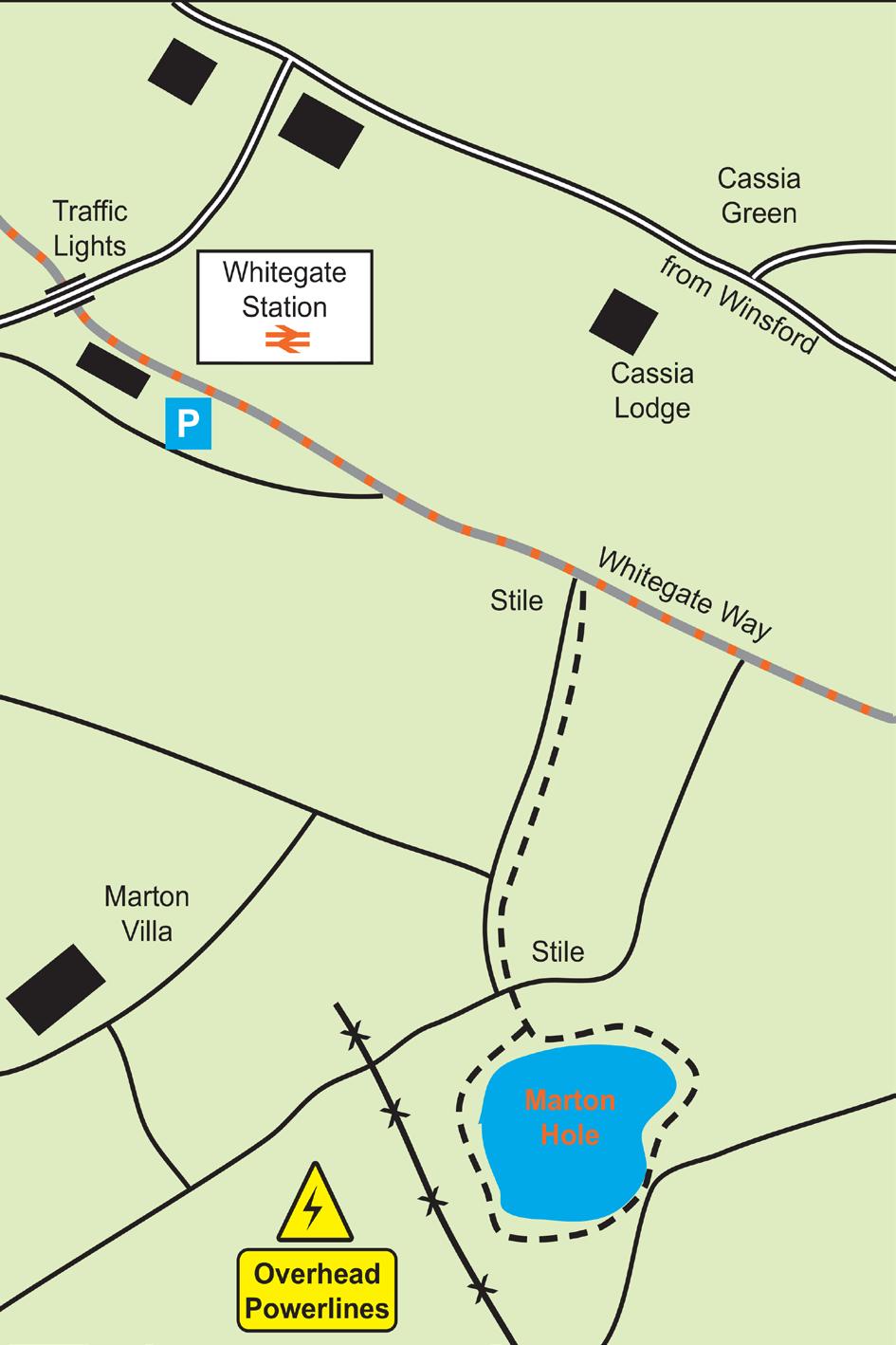
22 Marton Hole From Winsford, follow the signs for Whitegate and then the signs for Whitegate Station. After traffic lights turn left into Whitegate Station and into car park. Walk right along Whitegate Way for a few hundred yards and you will see a stile on your right. Follow the footpath down to the lake. Special Rules: (i) Access via Whitegate Station only. (ii) From 1st April to 31st May, working party members only. (iii) Proper access must be made to all waters as shown in the official Association maps. See the inside front cover of this permit for angling times. (iv) Fishing is only permitted from the bank shown on the map with a dotted line. All other banks are out of bounds, due to their dangerous conditions and constant subsidence. (v) The water at this venue is extremely deep and the banks are very steep - junior members should be accompanied by a senior at all times.
23

24 The Ocean From the centre of Winsford turn into Grange Lane (Verdin Exchange on the corner). Follow the road down to car parks at the bottom - park considerately as there is a clamping policy for wrongly parked cars! Access to the water is via the golf course. A new access road and car park nearer to the water is under discussion - so watch this space! Special Rules: (i) A daily limit of 14 anglers fishing from official swims only. (ii) Correct access to be used at all times. (iii) 12 months fishing allowed. (iv) For your own personal safety from mishit golf balls you should always fish under an umbrella. (v) Fishing is not permitted beyond the 11th tee on the golf course or between the limit boards displayed in the lake. (vi) See the inside front cover of this permit for angling times. NO NIGHT FISHING ALLOWED ON THE OCEAN
25
 Only to be fished by juveniles accompanied by adults.")
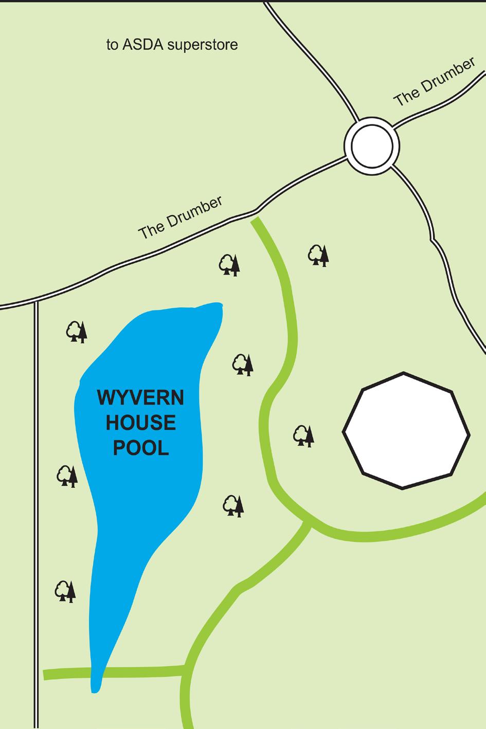
26 Wyvern House Pool - Juniors only From the centre of Winsford turn into Dingle Lane. At the roundabout take the second exit into The Drumber. At the next roundabout take the second exit again. Wyvern House Pool is situated on the next road on your left. Special Rules: (i) Only to be fished by juveniles accompanied by adults. (ii) All litter and line is to be removed from your peg before and after fishing. You will be held responsible for any litter found in or near your peg. (iii) Do not aggravate, pester or generally annoy the swans, ducks or whatever other wildlife is around. (iv) Maximum line strength to be used is 5lbs. (v) Only float fishing is allowed. (vi) There is a daily limit of 10 anglers only. (vii) Angling from marked pegs only. (viii) Barbless hooks only and non bigger than a size 14 to be used. (ix) Please respect the high profile surroundings as we are only allowed to fish this water if we satisfy the Council that we are responsible anglers. If we do not treat the wildlife and surroundings with respect we will lose the rights to fish here. It's your choice - abuse it and lose it! (x) The pool is now open all year round for angling.
27

28 River Dane (Middlewich) From Winsford follow signs for Middlewich via Station Road (A54). After entering Middlewich, turn left at the first mini roundabout into Croxton Lane (A530). After the garden centre on your left you will see a roadside car park on your left. Follow the signs for rubbish tip down to canal bank. Walk down the canal towpath to the aqueduct. Access to the river is from the left of the towpath. Alternatively walk along the A530 over the canal bridge to the bridge over the Dane. Fishing is allowed from the right hand bank upstream, as far as King Street bridge. Special Rules: (i) This water is now a members only water and consequently no day tickets will be sold.
29

30 South Cheshire Trent and Mersey Canal share scheme. 12 months fishing from Red Shale carpark, bridge 160 Moss Lane Elworth to Bridge 167 Kings Lock Booth Lane Middlewich


31 Bridge 167 Kings Lock, Booth Lane Middlewich Bridge 160 Moss Lane Elworth
Danbury Words and pictures by Laurie Page of the Public Rights of Way team at Essex County Council.
 Danbury Words and pictures by Laurie Page of the Public Rights of Way team at Essex County Council. An undulating walk from Danbury village to the bluebells at the National Trust property of Blakes Wood.
Stocks Carp to 32lb Roach to 1lb Tench to 9lb Perch to 2lb Bream to 14lb Rudd to 1lb Crucian to 2lb Pike 18lb
 Church Farm Location: Yateley Road, Sandhurst Berkshire (OS grid reference SU826616) Local Police: 0845 850 5505 (Thames Valley Police) Rod Limit: 3 rods (See 3 rd rod rule) Night : Yes (see special notes
The Hundred Parishes
 The Hundred Parishes Walks from railway stations number 9 6.4 miles (10kms) from Bishop s Stortford to Stansted Mountfitchet Start: Bishop s Stortford station (Grid Reference TL492209) (ample parking and
Marteg to Newbridge, October 2012 onwards.
 Marteg to Newbridge, October 2012 onwards. Map symbols: Reach Length: 12.4 miles Terms and Conditions: Canoeing can take place only when the water height is above 0.8m on the EAW gauge at Dhol Farm AND
Welsh Newton and Woodland
 Welsh Newton and Woodland This is a 8.2km miles (approx) walk which will take about 2.5 hours at a relaxed and leisurely pace. There are a few hills but no steep inclines. Start at Llangrove bus stop and
CYCLING TIME TRIALS The national governing body for CYCLING time trials
 CYCLING TIME TRIALS The national governing body for CYCLING time trials www.ctt.org.uk SOUTH DISTRICT COUNCIL COURSE DETAILS FOR START SHEETS & RISK ASSESSMENT INDEX Guidance Notes for Event Promoters
Site Working Information Card: River Chess, Chesham Lawn Tennis and Squash club, Pednormead End, Chesham, Bucks HP5 2JU Grid Ref: SP
 Site Working Information Card: River Chess, Chesham Lawn Tennis and Squash club, Pednormead End, Chesham, Bucks HP5 2JU Grid Ref: SP 955 013 Chesham Lawn Tennis and Squash Club Pednormead End Chesham,
A Walk around Holmes Chapel starting & finishing at Holmes Chapel Railway Station. by Tony & Lindsay Wright (2016)
") A Walk around Holmes Chapel starting & finishing at Holmes Chapel Railway Station. by Tony & Lindsay Wright (2016) Introduction Holmes Chapel Railway Station is on the Crewe to Manchester line. The station
A Walk around Holmes Chapel starting & finishing at Holmes Chapel Railway Station. by Tony & Lindsay Wright (2016) Introduction Holmes Chapel Railway Station is on the Crewe to Manchester line. The station
PLEASE READ THE RACE INSTRUCTIONS
 RACE INFORMATION Event Date: 30th September Venue: Ancholme Leisure Centre, Brigg, North Lincolnshire Start Time: 8:00am Race Registration: Saturday 29rd Sept 5.00pm 6.00 pm Sunday 24th Sept 6:00am 7:00am
Bonnie Prince Charlie Walk
 Bonnie Prince Charlie Walk A waymarked route from Ashbourne to Derby to celebrate the 60th anniversary (1995) of the formation of the Ramblers' Association. This route follows the general direction of
Angel Drove carpark 3/day
 GETTING TO ELY ( A on the map below marks the city centre; for a larger scale see the map at the end of the directions, where there are also details of car parking and pedestrian access to the venue) Angel
Dyrham and Hinton Parish Walks
 Dyrham and Hinton Parish Walks A series of five walks in the parish, exploring most of the public footpaths. By John Miller Each walk is described in detail, with a complete map, to provide a handy guide
PLEASE READ THE RACE INSTRUCTIONS
 RACE INFORMATION Event Date: 21 st September 2014 Venue: Ancholme Leisure Centre, Brigg, North Lincolnshire Start Time: 8:00am Race Registration: Saturday 20 th Sept 5.00pm 6.00 pm Sunday 21 st Sept 6:30am
Everybody Nordic Walking May 2016 Regular Walks
 Everybody Nordic Walking May 2016 Regular Walks Leisure Development Floor 3 Delamere House Delamere Street Crewe CW1 2JZ Welcome to all those new Nordic Walkers who have just recently completed the technique
Greenwood. Walks. Cossall Canal Walk. Cossall Canal Walk
 Cossall Canal Walk C5 Cossall Canal Walk C5 Features: Cossall is a picturesque, relatively unspoiled village on the Nottingham canal, four miles south-east of Eastwood. Architecturally interesting. See
Although the majority of these walks are around country lanes you should still follow the Country Code:-
 With the update of the Parish Plan was a request for details of any Walks around Pillaton The following pages give several walks that I and my wife have done for many years. Please be aware that NONE OF
SUMMER WALK 10. The Chairmakers, Worlds End
 SUMMER WALK 10 The Chairmakers, Worlds End Tuesday 10 th June 7.30pm This is a very short walk made so due to the majority of the footpaths in the area around the Chairmakers being overrun with high nettles
WETHERBY CIRCULAR by Tania Dickinson
 WETHERBY CIRCULAR by Tania Dickinson This walk in lower Wharfedale includes a disused railway line at the beginning and riverside at the end, with parkland, fields, woodland and villages in between. Distance
The Mendip Way. Route Directions and Maps Wells to Frome
 The Mendip Way Route Directions and Maps Wells to Frome Website: www.mendiphillsaonb.org.uk Email: mendip@mendiphillsaonb.org.uk Facebook & Twitter: @MendipHillsAONB Phone: 01761462338 1 Wells to Shepton
NETTLESTEAD & YALDING
 NETTLESTEAD & YALDING ULL CIRCUIT - Sheet 1 (first and last sections) Open fields (see 'Introductory Notes') 88 Direction label (as in the walk notes) ROADS: 81 10m Significant roads Redhill arm North
Lincolnshire Walks. Grainthorpe. Three circular walks of 2 ¾, 9 and 9 ½ km (1 ¾, 5 ½ and 6 miles)
") Lincolnshire Walks Grainthorpe Three circular walks of ¾, 9 and 9 ½ km (1 ¾, ½ and 6 miles) Introduction Explore the coastal marshes, arable hinterland, Louth Navigation canal and the village of Grainthorpe
Lincolnshire Walks Grainthorpe Three circular walks of ¾, 9 and 9 ½ km (1 ¾, ½ and 6 miles) Introduction Explore the coastal marshes, arable hinterland, Louth Navigation canal and the village of Grainthorpe
No. 1 By River Ribble & Brungerley Park 3¼ Miles,
 RVRNEWS 102 No. 1 By River Ribble & Brungerley Park 3¼ Miles, Approx 2 Hours This walk starts at the gate on platform 2 of Clitheroe station. Leaving the station turn left making towards Kirkmoor Rd and
To Let by Informal Tender FISHING RIGHTS. Situated near. Great Haywood and Milford in. Staffordshire. Tender Deadline
 To Let by Informal Tender FISHING RIGHTS Situated near Great Haywood and Milford in Staffordshire Tender Deadline FRIDAY 8 November 2013 AT 12.00 NOON 12 STAFFORD STREET ECCLESHALL STAFFORDSHIRE ST21 6BH
RILLINGTON TO MALTON by Tania Dickinson
 RILLINGTON TO MALTON by Tania Dickinson This walk takes you from the Vale of Pickering up on to the Wold scarp, before dropping down again through the pretty village of Settrington and joining the Centenary
Walk Description. Directions
 Title: Saffron Trail: Battlesbridge to Chelmsford Distance: 14¾ miles Time taken: 6 hours Start Point: Outside the Barge Inn, Battlesbridge OS Explorer Map: 175 & 183 Grid Ref.: TQ 780 947 Transport: Rail:-
Green Man Ultra Route Directions 2018
 Green Man Ultra Route Directions 2018 Start-CP1 (9 miles) Community Forest Path (CFP) Frome Valley Way (FVW) From the starting line cross the playing fields diagonally to the metal gates in the hedge lined
This walk description is from happyhiker.co.uk
 This walk description is from happyhiker.co.uk Pendle Hill Walk From Barley Starting point and OS Grid reference Ordnance Survey map Distance Traffic light rating Barley village honesty box car park OS
Dorridge & District Residents Association A Walk Along The Green Belt From Dorridge to Catherine-de-Barnes
 Dorridge & District Residents Association A Walk Along The Green Belt From Dorridge to Carine-de-Barnes The starting section of this walk through open fields would be destroyed by building of motorway
Walk Description. Directions
 Title: East Hanningfield Distance: 8 miles / 9 miles Time taken: 3-3½ hours Location: 5 miles south east of Chelmsford Parking: Free car park off The Tye, East Hanningfield, next to the primary school
Bakewell Club Site - Robin Hood's Stride
 Bakewell Club Site - Robin Hood's Stride Camping and Caravanning Route Summary A circular walk with fabulous views winding it's way through the beautiful White Peak scenery. Points of interest include
CYCLING TIME TRIALS The national governing body for CYCLING time trials
 The national governing body for CYCLING time trials www.ctt.org.uk SOUTH DISTRICT COUNCIL COURSE DETAILS FOR START SHEETS & RISK ASSESSMENT COURSE NUMBER P235/10 INDEX Guidance Notes for Event Promoters
Thornton le Dale Walks
 Thornton le Dale Walks A collection of circular walks in, and around, the village www.visitthorntonledale.co.uk Thornton-le-Dale Traders Forum and Thornton le Dale Parish Council 1 Thornton le Dale Circular
Hammer Vale and Linchmere Common
 point your feet on a new path Hammer Vale and Linchmere Common Distance: 9 km=5½ miles or 6 km=3¾ miles easy walking with one steep section Region: Hampshire, West Sussex Author: Botafuego Refreshments:
How to get there. Respect - Protect - Enjoy
 How to get there Driving: Postcode is RG9 3DG and there is a carpark just across from the pub. Nearest station: Henley-on-Thames station is 5.6 miles away. We re delighted to present three circular walks
Lincolnshire Walks. Ancaster. Three cir cular walks of2 3/4,4or 6km (11/3, 21/2 or 33/4 miles)
") Lincolnshire Walks Ancaster Three cir cular walks of2 3/4,4or 6km (11/3, 21/2 or 33/4 miles) Introduction These walks are set in the attractive countryside around the historic town of Ancaster. The town
Lincolnshire Walks Ancaster Three cir cular walks of2 3/4,4or 6km (11/3, 21/2 or 33/4 miles) Introduction These walks are set in the attractive countryside around the historic town of Ancaster. The town
8 Miles Circular 4 hours
 VISIT RYEDALE HELMSLEY AND RICCAL DALE 8 Miles Circular 4 hours 090616 Challenging Terrain An 8 mile (13km) circular walk from the market town of Helmsley in Ryedale. The route heads out across sheep pastures
WALK WELL IN TAUNTON AND WELLINGTON WINTER 2017/18
 WALK WELL IN TAUNTON AND WELLINGTON WINTER 2017/18 www.walkwellwithtone.btck.co.uk Walk Well Taunton Deane WHAT IS A HEALTH WALK? It s a brisk walk done on a regular basis for well-being. It can help you
Approximate distance: 10 miles For this walk we ve included OS grid references should you wish to use them. Start. End
 Approximate distance: 10 miles For this walk we ve included OS grid references should you wish to use them. 2 3 Start End 1 N W E S Reproduced by permission of Ordnance Survey on behalf of HMSO. Crown
LDWA SOUTH DOWNS MARATHON 13 th MAY 2018
 AHD ahead SDW South Downs Way BL/BR bear left/bear right TL/TR turn left/turn right X cross LEG 1 - EAST DEAN to WP1 NORTON GR 470019. Open 1030 to 1300. 9.7 miles. 1.1 From village hall TL and walk to
Regulatory traffic signs
 Section 21: Regulatory traffic signs This section includes the signs that show a road regulation is in place. These must be obeyed. Regulatory signs show the course a driver must follow and an action they
Thornton le Dale Walks
 Thornton le Dale Walks A collection of walks in and around the village Thornton le Dale Traders Forum www.visitthorntonledale.co.uk Thornton le Dale Walks Walk 1: Beck Isle Cottage and All Saints Church
Venue Information - Access to the Greenway
 Venue Information - Access to the Greenway Coachford Greenway The Coachford Greenway at Inniscarra Reservoir (Lake) in the locality of Coachford Co. Cork, Ireland is a multi-purpose amenity for everyone
Lloyds Banking Group Lean On Me Challenge 2017
 Lloyds Banking Group Lean On Me Challenge 2017 Mapbook Halifax Hike September 29 In aid of Mental Health UK Join the Facebook Group Lean On Me Challenge For updates on the event Or follow on Twitter under
LDWA SOUTH DOWNS MARATHON
 AHD ahead SDW South Downs Way BL/BR bear left/bear right TL/TR turn left/turn right SP signpost/fingerpost X cross LEG 1 - EAST DEAN to WP1 NORTON GR 470019. Open 1030 to 1300. 9.6 miles. 1.1 From village
CYCLING TIME TRIALS. The national governing body for CYCLING time trials SOUTH DISTRICT COUNCIL COURSE DETAILS FOR START SHEETS
 CYCING TIME TRIAS - SOUTH DISTRICT COUNCI CYCING TIME TRIAS The national governing body for CYCING time trials www.ctt.org.uk SOUTH DISTRICT COUNCI COURSE DETAIS FOR START SHEETS & RISK ASSESSMENT COURSE
Chichester Harbour. A Walker s Guide
 A Walker s Guide - Chichester Harbour Chichester Harbour A Walker s Guide Chichester Harbour is an Area of Outstanding Natural Beauty on the south coast of Britain. Virtually flat with far reaching sea
holly tree Wellhill Farm Woodyard Bramham House red kites Round House ha-ha
 This 6.4 mile walk around the magnificent Bramham Park Estate has been made possible with the active support of the owner of the Estate, Nick Lane Fox, with funding from Natural England, as part of Defra
Sussex FDG Branch Outings Fly Fishing for Pike, Weirwood Reservoir
 Sussex FDG Branch Outings Fly Fishing for Pike, Weirwood Reservoir When Friday 1st October 2010 & Saturday 13th November 2010 Meet 7.30am for 8am breakfast Where Weir Wood Reservoir, The Fishing Lodge,
Route: Skewsby Foulrice Stearsby
 Route: Skewsby Foulrice Stearsby Distance: 7 miles Map: Explorer: 300 Howardian Hills & Malton Start (OS ref): SE625710 Park in the village of Skewsby. Walk east out of the village to the T-Junction and
10 km Circular 3 hours
 FRIMLEY AND FRIMLEY GREEN 10 km Circular 3 hours Easy Terrain 250716 A 10km (6 mile) circular walk exploring the canal towpath, riverside path, woodland, heath and small settlements around Frimley in Surrey.
A mainly flat walk along the Peak Forest Canal to Castle Hill and returning along the River Tame via Hulmes Wood and Haughton Dale.
 Walk 9 Haughton Green, Peak Forest Canal, Castle Hill, Hulmes Wood, River Tame, Haughton Dale Circular Miles: 3.9 Time: 1 Hour 30 Minutes Grade: Easy To Moderate Starting Point: Junction Of Gibraltar Lane/Newport
HARDMOORS 26.2 WHITE HORSE HALF ROUTE DESCRIPTION - 018
 HARDMOORS 26.2 WHITE HORSE HALF ROUTE DESCRIPTION - 018 Follow Cleveland Way, keeping to the left hand path (right path is a bike trail) Ignoring any turnings to the left or right At path junction (after
Lymm Angling Club Rules 2017
 Lymm Angling Club Rules 2017 The rules governing members and other persons fishing waters or at club events are based on item 33 of the club constitution, which will apply to any situation not specifically,
& r al. Two circular walks of 8 km (5 miles) wal k
 wal k") & Ru r al Two circular walks of 8 km (5 miles) s ford Riv m a t S er wal k Introduction Stamford is noted as being one of the finest stone towns in the country. The stone being local limestone and Collyweston
& Ru r al Two circular walks of 8 km (5 miles) s ford Riv m a t S er wal k Introduction Stamford is noted as being one of the finest stone towns in the country. The stone being local limestone and Collyweston
ST. AGNES. you cannot put a time limit on beauty.
 ST. AGNES CIRCULAR WALKS AROUND There are many enjoyable and picturesque walks around St. Agnes most are signposted and are featured on the St. Agnes Mini-guide map. Because most of our footpaths are in
CYCLING TIME TRIALS The national governing body for CYCLING time trials
 The national governing body for CYCLING time trials www.ctt.org.uk SOUTH DISTRICT COUNCIL COURSE DETAILS FOR START SHEETS & RISK ASSESSENT COURSE NUBER P311 INDEX Guidance Notes for Event Promoters Summary
Hawkesbury Canal Junction. (Sutton Stop) Near Coventry.
 Near Coventry.") Hawkesbury Canal Junction. (Sutton Stop) Near Coventry. Starts at Hawkesbury Canal Junction,Blackhorse Road,Bedworth 1 hours 49 minutes 5.5miles 8.9km Leisurely ID: 0.1798 Developed by: Peter Hopewell
Hawkesbury Canal Junction. (Sutton Stop) Near Coventry. Starts at Hawkesbury Canal Junction,Blackhorse Road,Bedworth 1 hours 49 minutes 5.5miles 8.9km Leisurely ID: 0.1798 Developed by: Peter Hopewell
AMAZING WALKS RIGHT ON YOUR DOORSTEP AT WALLOPS WOOD COTTAGES!
 Wallops Wood Cottages Sheardley Lane, Droxford, Hampshire, SO32 3QY emma@wallopswoodcottages.co.uk T: 01489 878888 Sign-up to our NEWSLETTER for special offers and news. You can also follow us on social
Walk 2 Village Hall - The Shippy - Woodhouse Farm - Village Hall
 Walk 2 Village Hall - The Shippy - Woodhouse Farm - Village Hall The walk is approximately 4km (2.5 miles) across fairly flat countryside with about a quarter on country lanes. It should take about 1 hour
Distance: 14 km=8½ miles or 7 km=4½ miles easy-to-moderate walking
 point your feet on a new path Normandy Distance: 14 km=8½ miles or 7 km=4½ miles easy-to-moderate walking Region: Surrey Author: Botafuego Refreshments: Pirbright, Ash date written: 20-feb-2012 date revised:
CYCLING TIME TRIALS The national governing body for CYCLING time trials
 The national governing body for CYCING time trials www.ctt.org.uk SOUTH DISTRICT COUNCI COURSE DETAIS FOR START SHEETS & RISK ASSESSMENT COURSE NUMBER P427 INDEX Guidance Notes for Event Promoters Summary
Launton to Bicester nature footpath improved
 Launton to Bicester nature footpath improved Published 13 July 2012 An attractive rural footpath linking Launton to Bicester has brought back into use by the council's Countryside team. Staff have improved
Short and healthy walks AROUND BEDALE. with Hambleton Strollers. North Yorkshire County Council
 Short and healthy walks AROUND BEDALE with Hambleton Strollers North Yorkshire County Council Bedale Strollers Why walk? Being active is good for our physical and mental health. Just 30 minutes of moderate
STEWARTBY WATER SPORTS CLUB - ANGLING SECTION CONSTITUTION AND RULES
 STEWARTBY WATER SPORTS CLUB - ANGLING SECTION CONSTITUTION AND RULES 1. NAME. The Section shall be known as the 'Stewartby Water Sports Club Angling Section'. 2. OBJECTS. To promote the sport of 'Angling'
Walks Around Bishopstone & Hinton Parva
 The Walks: From ½ mile ambles to 8 mile scenic loops Hinton Parva Walks H1 H2 H3 Bishopstone Walks B1 B2 B3 B4 B5 Walk B1: Bishopstone Village, The Dingle (stream) & Pond A short circular village amble
Rhebogue Neighbourhood Greenway. Road Safety Audit Stage 2
 Rhebogue Neighbourhood Greenway Road Safety Audit Stage 2 Report Number: 12/007/00/00057 July 2014 Mid West National Road Design Office Lissanalta House, Dooradoyle County Limerick Tel: 061 496 800 Fax:
9.5 km Circular 3 hours
 MEDIEVAL WAVERLEY Challenging Terrain A 6 mile (9.5km) undulating circular walk from Tilford village passing close to The Sands village and the historic ruins of Waverley Abbey. From the top of Crooksbury
Oldbury & Littleton, South Gloucestershire
 Oldbury & Littleton, South Gloucestershire Starts at Church Lane, Oldbury. BS35 1QF 2 hours 0 minutes 5.2miles 8.4km Easy ID: 0.2468 Developed by: GEOFF MULLETT Checked by: Marion Stone www.ramblersroutes.org
Lincolnshire Limewoods Walks. Woodhall Spa. A circular walk of 13km (8 miles)
") Lincolnshire Limewoods Walks Woodhall Spa A circular walk of 13km (8 miles) Introduction The Lincolnshire Limewoods is an area between Wragby, Bardney and Woodhall Spa. It is a fantastic place to explore
Lincolnshire Limewoods Walks Woodhall Spa A circular walk of 13km (8 miles) Introduction The Lincolnshire Limewoods is an area between Wragby, Bardney and Woodhall Spa. It is a fantastic place to explore
Rowany Golf Club Limited RISK ASSESSMENT
 Copyright Rowany Golf Club 2016 2a Berkeley Street Lane, Douglas, Isle of Man IM2 3RN Introduction This document assesses the risks associated with Rowany Golf Course, in order that that Rowany Golf Club
Walk 2: Beamsley Beacon and Bolton Abbey
 Walk 2: Beamsley Beacon and Bolton Abbey Start and Finish: The Memorial Hall, Main Street, Addingham, LS29 0LZ, SE 079 497 The shortest walk is about 5½ miles (8.8km) The medium Walk is about 8¼ miles
LOCAL CIRCUIT EM1: EAST MALLING & BARMING HEATH. N 2m ROADS: Significant roads PATHS: Starting direction Barming Longsole Mission Church
 Ditton Church Scott Close LOCAL CIRCUIT EM1: EAST MALLING & BARMING HEATH 6 Community Centre F Open fields (see 'Introductory Notes') 1m 88 Direction label (as in the walk notes) East Malling Church -
Cycle routes from Guildford
 Cycle routes from Guildford The following five pages give practical information about following the main cycle routes from Guildford. There are now several good trafficfree routes in the area, and Guildford
How to get there. Respect - Protect - Enjoy
 How to get there Driving: Postcode is RG9 5PF and there is a car park just across from the pub. Nearest station: Henley-on-Thames station is 5.6 miles away. We re delighted to present three circular walks
Sandilands to Huttoft Bank
 Coastal Country Park Walks Sandilands to Huttoft Bank A CIRCULAR WALK OF 11KM (7 MILES) INTRODUCTION The Lincolnshire Coastal Country Park lies between Sandilands, Chapel St Leonards and Huttoft on the
COLEMANS COTTAGE FISHERY MATCH RULES REVISED FEBRUARY 2011
 The gates open from 7.00am and close at 7pm in the summer months. From October each year the gates will open at dawn and close at dusk. On Match days breakfasts are served from 7am...Match organisers can
Walk 3 - Woodbridge and Melton A Walk Round Waldringfield by Sue and Jim Stacey. Woodbridge. shopping centre, cafes, toilets etc. tide mill.
 Walk 3 - Woodbridge and Melton A Walk Round Waldringfield by Sue and Jim Stacey. road with roundabout church railway with station walk route showing description direction track, wide path, bridlepath footpath
TOCKENHAM. Walks for Healthy Living. The Countryside Code (October 2016) Respect other people:
 Respect other people:") The Countryside Code (October 2016) TOCKENHAM Respect other people: consider the local community and other people enjoying the outdoors leave gates and property as you find them and follow paths unless
The Countryside Code (October 2016) TOCKENHAM Respect other people: consider the local community and other people enjoying the outdoors leave gates and property as you find them and follow paths unless
Cycle Tendring. Great Bicycle rides around the Harwich, Manningtree and Mistley area
 Great Bicycle rides around the Harwich, Manningtree and Mistley area Why not discover and explore the beauty of the Tendring Peninsula by bike? There s nothing like following the beautiful coastline or
BALCOMBE AND ARDINGLY RESERVOIR, WEST SUSSEX
 BALCOMBE AND ARDINGLY RESERVOIR, WEST SUSSEX 7 miles Circular 4 hours 080816 Challenging Terrain Hi, I'm Luke and this is my West Sussex Weekends walk It's a 7 mile loop from Balcombe rail station, taking
Shepherdswell - Dover
 Shepherdswell - Dover The North Downs Way > Shepherdswell to Dover Introduction This part of the path is slightly different in character from most other parts of the path since it spends much of the time
I #. Short and healthy walks. AROUND Bedale. With Hambleton Strollers
 I #. Short and healthy walks AROUND Bedale With Hambleton Strollers Why walk? Being active is good for our physical and mental health. Just 30 minutes of moderate activity, such as brisk walking, 5 times
For more information and to buy this book click here ISBN: CICERONE. Guides for walkers, trekkers, mountaineers, climbers and cyclists
 For more information and to buy this book click here ISBN: 9781852845377 CICERONE Guides for walkers, trekkers, mountaineers, climbers and cyclists www.cicerone.co.uk WALK 5 Ouston and Urpeth Distance
Tideswell to Castleton
 Tideswell to Castleton 1 Walk summary Length: 14 km, 8.5 miles Maps: OS Explorer OL1 The Peak District - Dark Peak Area, OS Explorer OL24 The Peak District - White Peak Area, OS Landranger 110 Sheffield
Waterhead Pier to Orrest Head, Windermere and Bowness
 Waterhead Pier to Orrest Head, Windermere and Bowness A 4 1 2 hour walk through Woodlands and the Troutbeck Valley with spectacular Lake and Mountain views and a lakeshore path. Walk 10 Walk 11 Walk 12
Ovington and Itchen Stoke
 Trail Activity Type Terrain Author Distance Ascent Location : HAMPTR0057 : Walk : Pub : Towpaths and Cycle Tracks : Peter Carne : 1.4 miles / 2.2 kms : 62 feet / 19 metres : SU560318 / SO24 0RE Bush Inn,
WALK WELL IN TAUNTON AND WELLINGTON WINTER 2018/2019
 WALK WELL IN TAUNTON AND WELLINGTON WINTER 2018/2019 walkwellwithtone.btck.co.uk Walk Well Taunton Deane WHAT IS A HEALTH WALK? It s a brisk walk done on a regular basis for well-being. It can help you
Winterfold Wood. point your feet on a new path. In Brief
 point your feet on a new path Winterfold Wood Distance: 8½ km=5¼ miles Region: Surrey Author: Schwebefuss Refreshments: Windmill Inn, Peaslake after the walk moderate walking with many gradients Date written:
Hitchin Nomads Cycling Club
 Hitchin Nomads Cycling Club Risk Assessment of Course Course Identification 1U/25 25 Miles - Southill / Old Warden Reviewed By Paul Riley Reviewed On 02/01/2018 Course Details https://www.plotaroute.com/route/346809
There are toilets at Manningtree Station, Flatford (close to the hump back bridge) and in Dedham.
 and in Dedham.") Arriving by Train Main Features of the Walk Outline Route Employs particularly attractive paths, many of which offer impressive views across Dedham Vale. Includes a section along the tidal section of the
Arriving by Train Main Features of the Walk Outline Route Employs particularly attractive paths, many of which offer impressive views across Dedham Vale. Includes a section along the tidal section of the
Marlow River Olympic Distance Triathlon. Sunday July 15th 2012, 6:00am - 12:00pm. Olympic Distance 1500 metre Swim, 37km Bike, 7.
 Marlow River Olympic Distance Triathlon Sunday July 15th 2012, 6:00am - 12:00pm Olympic Distance 1500 metre Swim, 37km Bike, 7.45km Run Competitor notes Thank you for entering the Maxifuel Marlow River
Hascombe and Winkworth Arboretum Downs Link Path, Smithbrook Kilns
 point your feet on a new path Hascombe and Winkworth Arboretum Downs Link Path, Smithbrook Kilns Distance: 18 km=11 miles Region: Surrey Author: RDC easy walking Date written: 7-may-2016 Last update: 30-aug-2018
Lymington Triathlon 30 TH August 2015
 Lymington Triathlon 30 TH August 2015 Race Start Time from 7am Lymington Sea Water Baths, Bath Road, Lymington SO41 3SE Directions From The South East / London: From M3 continue onto M27 Westbound. Exit
A Sporting Start (2016 Andi Cap)
") Joanne and Jeremy Norfolk present A Sporting Start (2016 Andi Cap) The Sportsman pub, Lower Kingswood, Surrey, KT20 7ES Sunday 23 rd April, 2.15 p.m. The Walk: A fairly easy-going walk, approx. 2.5 miles
Joanne and Jeremy Norfolk present A Sporting Start (2016 Andi Cap) The Sportsman pub, Lower Kingswood, Surrey, KT20 7ES Sunday 23 rd April, 2.15 p.m. The Walk: A fairly easy-going walk, approx. 2.5 miles
Traffic signs used, including signs giving orders, warning signs, direction signs, information signs and road works signs.
 Traffic signs Traffic signs used, including signs giving orders, warning signs, direction signs, information signs and road works signs. Although The Highway Code shows many of the signs commonly in use,
Cliveden Cross Country Sunday 7 January 2018, 9.00am Under UK Athletics Rules SEAA Race Permit
 Cliveden Cross Country Sunday 7 January 2018, 9.00am Under UK Athletics Rules SEAA Race Permit 2018 31623 Welcome to another post-christmas test of endurance and fitness at Cliveden presented by kind permission
Gainsborough and Fledborough Circular
 Trent Vale Cycle Route TVCR18 Gainsborough and Fledborough Circular Gainsborough Old Hall. One of the biggest and best preserved Medieval Manor Houses in England. Start Point: Gainsborough Marshall s Yard
TORONTO MUNICIPAL CODE CHAPTER 886, FOOTPATHS, PEDESTRIAN WAYS, BICYCLE PATHS, BICYCLE LANES AND CYCLE TRACKS. Chapter 886
 Chapter 886 FOOTPATHS, PEDESTRIAN WAYS, BICYCLE PATHS, BICYCLE LANES AND CYCLE TRACKS 1 886-1. Definitions. 886-2. Paths established. 886-3. Vehicles excluded; exceptions. 886-4. Pedestrian ways established.
10Km Road Race - Race Day Info Sheet
 Denmead Striders Running Club 10Km Road Race - Race Day Info Sheet Sunday 14 th October 2018 at 10:00am (UKA Licence No: 2018-33481) Thank you for entering the fifth running of the Denmead 10km Road Race
Approximate distance: 5.5 miles For this walk we ve included OS grid references should you wish to use them. Start. End
 Approximate distance: 5.5 miles For this walk we ve included OS grid references should you wish to use them. End 4 1 Start 3 2 N W E S Reproduced by permission of Ordnance Survey on behalf of HMSO. Crown