Target Fish Communities and the MA Water Policy
|
|
|
- Amber Arnold
- 5 years ago
- Views:
Transcription
1 Target Fish Communities and the MA Water Policy Todd Richards MA Division of Fisheries and Wildlife
2 MA Water Policy (2004) Principle: Protect Fish and Wildlife Habitat Recommendation: Conduct Target Fish Community Assessments EEA Funded 2 Employees to Work with F&W
3 Developing a Target Fish Community Goal: Define the fish community that is appropriate for a natural river in southern New England (Bain and Meixler, 2000) Assumption: Biological Integrity should be Maintained and is defined by a balanced, integrated, adaptive community (Karr, 1991) Rivers Should Have River Fish Communities
4 Fish Community Assessment The Fish Tell the Story Long-Lived Reflect Stresses Over Time Easily Recognized and Identified
")
5 Rivers Should Have River Fish Communities What is a River Fish? Fluvial Specialists- FS-(Require Flowing Water - brook trout)
6 Rivers Should Have River Fish Communities What is a River Fish? Fluvial Dependents-FD- (Need Flowing Water at Some time in Their Life Cycle - white sucker)

7 Rivers Should Have River Fish Communities What is a River Fish? Macrohabitat Generalists-MG-(Don t Require Flowing Water - largemouth bass)
8 Completed Target Fish Communities Ipswich USFWS and IRWA, 2001 MG 29% FD 20% Charles CRWA and Cornell, 2006 FS 51% MG 25% FD 25% FS 50% 12% 18% MG 25% FD 25% 70% Housatonic MA Riverways 2004 FS 50% Quinebaug Cornell, 2000
9

10 Reference Rivers Determine Potential Reference Rivers Based on Physical Characteristics Collect Existing Fisheries and Status Info Describe Reference River Fish Communities There are no true references
11 Data Contributions and Reference Consultation CT DEP Connecticut Department of Environmental Protection- Fisheries MA DFW Massachusetts Division of Fisheries and Wildlife NEIHP Northeast Instream Habitat Program NH DES New Hampshire Department of Environmental Services NYSDEC New York State Department of Environmental Conservation RI DEM Rhode Island Department of Environmental Management, Division of Fish and Wildlife USGS U.S. Geological Survey National Water-Quality Assessment Program (NAWQA) VT DEC Vermont Department of Environmental Conservation WPWA Wood-Pawcatuck Watershed Association
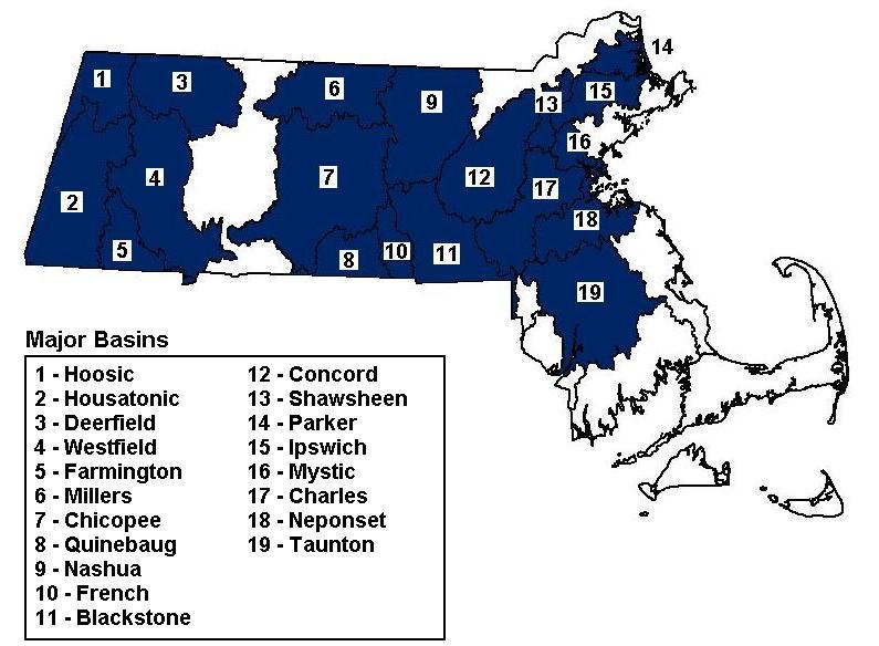
12 Concord River Summary River Characteristics Drainage Area: 400 sq miles Stream Order: 5 th Mainstem Length: km Elevation: ft Gradient: 0-0.5% EPA Level III Ecoregion: 59 River Basin Map Target Fish Community Bridle Shiner 3% Brook Trout 3% Tesselated Darter 4% American Eel 4% Redbreast Sunfish 6% White Sucker 9% Other 14% Other Yellow Perch 3% Pumpkinseed 2% Chain Pickerel 2% Brown Bullhead 2% Redfin pickerel 2% Golden Shiner 2% Creek Chubsucker 1% Fallfish 37% Common Shiner 19% Other: Yellow Perch 3% Pumpkinseed 2% Chain Pickerel 2% Brown Bullhead 2% Redfin Pickerel 2% Golden Shiner 2% Creek Chubsucker 1% Species grouped by Habitat Use Categories (HUC) 48% Fluvial Specialists 27% Fluvial Dependents 25% Macrohabitat Generalists Reference Rivers River State Drainage area (mi²) Stream order Calcareous geology Grad. class Elv. class Level III Ecoregion Lamprey River NH Acidic North River NH Acidic Pawcatuck River RI Acidic Piscataquog River NH Acidic Willimantic River CT Acidic Gradient class:1 = 0-0.5% Elevation class:1 = ft Figure 5a. Concord River summary
13 Concord River Summary River Characteristics Drainage Area: 400 sq miles Stream Order: 5 th Mainstem Length: km Elevation: ft Gradient: 0-0.5% EPA Level III Ecoregion: 59 River Basin Map Target Fish Community Bridle Shiner 3% Brook Trout 3% Tesselated Darter 4% American Eel 4% Redbreast Sunfish 6% White Sucker 9% Other 14% Other Yellow Perch 3% Pumpkinseed 2% Chain Pickerel 2% Brown Bullhead 2% Redfin pickerel 2% Golden Shiner 2% Creek Chubsucker 1% Fallfish 37% Common Shiner 19% Other: Yellow Perch 3% Pumpkinseed 2% Chain Pickerel 2% Brown Bullhead 2% Redfin Pickerel 2% Golden Shiner 2% Creek Chubsucker 1% Species grouped by Habitat Use Categories (HUC) 48% Fluvial Specialists 27% Fluvial Dependents 25% Macrohabitat Generalists Reference Rivers River State Drainage area (mi²) Stream order Calcareous geology Grad. class Elv. class Level III Ecoregion Lamprey River NH Acidic North River NH Acidic Pawcatuck River RI Acidic Piscataquog River NH Acidic Willimantic River CT Acidic Gradient class:1 = 0-0.5% Elevation class:1 = ft Figure 5a. Concord River summary
14 Concord River Summary River Characteristics Drainage Area: 400 sq miles Stream Order: 5 th Mainstem Length: km Elevation: ft Gradient: 0-0.5% EPA Level III Ecoregion: 59 River Basin Map Target Fish Community Bridle Shiner 3% Brook Trout 3% Tesselated Darter 4% American Eel 4% Redbreast Sunfish 6% White Sucker 9% Other 14% Other Yellow Perch 3% Pumpkinseed 2% Chain Pickerel 2% Brown Bullhead 2% Redfin pickerel 2% Golden Shiner 2% Creek Chubsucker 1% Fallfish 37% Common Shiner 19% Other: Yellow Perch 3% Pumpkinseed 2% Chain Pickerel 2% Brown Bullhead 2% Redfin Pickerel 2% Golden Shiner 2% Creek Chubsucker 1% Species grouped by Habitat Use Categories (HUC) 48% Fluvial Specialists 27% Fluvial Dependents 25% Macrohabitat Generalists Reference Rivers River State Drainage area (mi²) Stream order Calcareous geology Grad. class Elv. class Level III Ecoregion Lamprey River NH Acidic North River NH Acidic Pawcatuck River RI Acidic Piscataquog River NH Acidic Willimantic River CT Acidic Gradient class:1 = 0-0.5% Elevation class:1 = ft Figure 5a. Concord River summary

15 Concord River Summary River Characteristics Drainage Area: 400 sq miles Stream Order: 5 th Mainstem Length: km Elevation: ft Gradient: 0-0.5% EPA Level III Ecoregion: 59 River Basin Map Target Fish Community Bridle Shiner 3% Brook Trout 3% Tesselated Darter 4% American Eel 4% Redbreast Sunfish 6% White Sucker 9% Other 14% Other Yellow Perch 3% Pumpkinseed 2% Chain Pickerel 2% Brown Bullhead 2% Redfin pickerel 2% Golden Shiner 2% Creek Chubsucker 1% Fallfish 37% Common Shiner 19% Other: Yellow Perch 3% Pumpkinseed 2% Chain Pickerel 2% Brown Bullhead 2% Redfin Pickerel 2% Golden Shiner 2% Creek Chubsucker 1% Species grouped by Habitat Use Categories (HUC) 48% Fluvial Specialists 27% Fluvial Dependents 25% Macrohabitat Generalists Reference Rivers River State Drainage area (mi²) Stream order Calcareous geology Grad. class Elv. class Level III Ecoregion Lamprey River NH Acidic North River NH Acidic Pawcatuck River RI Acidic Piscataquog River NH Acidic Willimantic River CT Acidic Gradient class:1 = 0-0.5% Elevation class:1 = ft Figure 5a. Concord River summary
16 Identifying the Current Status: Concord River Similarity Index Fish species Fallfish Common shiner White sucker Redbreast sunfish American eel Tesselated darter Brook trout Bridle shiner Yellow perch Pumpkinseed Chain pickerel Brown bullhead Redfin pickerel Golden shiner Creek chubsucker Largemouth bass* Yellow bullhead* Bluegill* Brown trout* Rock bass* Rainbow trout* Blacknose dace Banded sunfish TFC Percentage Current Community Percentage Absolute Difference 27.9 Total Percent Similarity (Novak and Bode)
17 Statewide Species Similarity Westfield 76 Hoosic 68 Quinebaug 62 Nashua 50 Housatonic Farmington Concord Wide Range of Watershed Conditions BM Other Shawsheen Charles EBT TD AE RBS F Ipswich 23 WS Blackstone 22 CS Percent Model Affinity (Species)
18 Species Scarcity Scarce or absent species indicate ecological conditions severely lacking; Examine 5 species predicted to be most abundant by TFC; Species considered scarce if the existing fish community percentage was 10% or less than that predicted by the TFC.
19 Scarcity Example Table 36. Blackstone River species percentages for target fish community model and current community composition. Absolute difference values between model expected and current community percentages were used to calculate percent model affinity. Fish species TFC Percentage Current Community Percentage Percent Fallfish Common shiner White sucker Longnose dace American eel Scarce Species

20 Mainstem River Condition Westfield Farmington Hoosic Housatonic Nashua Quinebaug Blackstone Charles Concord Ipswich Shawsheen
21 Prioritizing Restoration: Westfield River (Green) River Species Proportions FD 19% MG 12% TFC FD 18% MG 11% Current Water Quantity and Physical Habitat FS 69% Measure of Pollution Tolerance FS 71% Percent Percent TFC Current 12 8 I M T Tolerance I M T Tolerance TFC Current Water Quality
22 Prioritizing Restoration: Nashua River (Yellow) River Species Proportions TFC Current MG MG 23% FS FS 30% 32% 36% Water Quantity and Physical Habitat FD 41% FD 38% Measure of Pollution - Tolerance Nashua River Percent I M T TFC Current Water Quality Pollution Tolerance
23 Prioritizing Restoration: Ipswich River (Red) River Species Proportions MG 28% TFC FS 26% Current FD 2% FS 2% Water Quantity and Physical Habitat FD 46% MG 96% Measure of Pollution Tolerance Percent Percent I M T Tolerance TFC Current TFC Current Water Quality 0 I M T Tolerance
24 Prioritizing Restoration: Concord River (Red) River Species Proportions MG 25% TFC FS 48% Current FS 12% FD 23% Water Quantity and Physical Habitat FD 27% MG 65% - Measure of Pollution Tolerance Concord River Percent Percent Concord River TFC Current I M T Tolerance I M T Tolerance TFC Current Water Quality
25 Summary Completion of 19 Target Fish Community Models Comparison of 11 Current Fish Communities to Corresponding Targets Generalize Water Quality/Quantity issues Provide a Product that can be Incorporated into Water Policy and Water Quality Standards Applications
Importance of Temperature and Flow for Fish in Connecticut Streams
 Importance of Temperature and Flow for Fish in Connecticut Streams Chris Bellucci, CT DEEP Water Monitoring and Assessment Program Climate Change Conference, Litchfield, CT September 23, 2016 Today s Talk
Montgomery Parks Biological Monitoring in the Anacostia Watershed of Montgomery County RESOURCE ANALYSIS SECTION
 Montgomery Parks Biological Monitoring in the Anacostia Watershed of Montgomery County PARK PLANNING & STEWARDSHIP Doug Redmond, Natural Resources Manager Montgomery County Department of Parks September
Fisheries Survey of Saratoga Lake
 Fisheries Survey of Saratoga Lake 7- Mark D. Cornwell Kevin Poole State University of New York College of Agriculture & Technology Department of Fisheries & Wildlife Cobleskill, NY ABSTRACT: This survey
SUMMARY OF RESULTS FIBI054
 SUMMARY OF RESULTS FIBI054 1. Stream Name: Lamington River 2. Sampling Date: 7/10/2007 3. Sampling Location: McCann Mill Road 4. Municipality Tewksbury Township 5. County: Hunterdon 6. Watershed Management
Conewago Creek Initiative. Fish Survey Report for the Conewago Creek
 Conewago Creek Initiative Fish Survey Report for the Conewago Creek A compilation of historic fish survey data from 97, 973, 7, for three locations along the Conewago Creek Prepared by Kristen Kyler for
Elk Lake, Antrim and Grand Traverse counties T. 28, 29 N., R. 8, 9 W., Sec. many. Lake surveys. began at 40 feet
 Elk Lake, Antrim and Grand Traverse counties T. 28, 29 N., R. 8, 9 W., Sec. many Physical and chemical data surveyed August 1931 Temperature ( F) Secchi disk (feet) 9. 6 Surface 74 Bottom 45 PH 8.0 Thermocline
Thunder Bay River Assessment Appendix. Appendix 2
 Appendix 2 Known past and present fish distributions in the River system. Distribution of fishes were compiled from Bailey et al. (2003) and from records located at the Michigan Department of Natural Resources
Penny Road Pond Population Survey
 Located in Barrington Hills on the south side of Penny Rd. west of Old Sutton Rd. This small 7 acre pond has a maximum depth of 4.6 feet and is connected to Spring Creek. The fish population of Penny Road
Pohatcong Creek - FIBI033
 DELAWARE RIVER Pohatcong Creek - FIBI033 Drainage Area of FIBI033: 9.8 Square Miles Surface Water Quality Classification of FIBI033: FW2-TM Washington #S "! 3 1 % P ohatcong Creek FIBI033 "! 57 Merri l
Columbia Lake Dam Removal Project
 Columbia Lake Dam Removal Project The Columbia Lake dam located 1/4 mile upstream of the Paulins Kill River's confluence with the Delaware River in Knowlton Township, Warren County has been proposed for
APPENDIX A. Stream Electrofishing Survey Data (2015)
") APPENDIX A Stream Electrofishing Survey Data (2015) This section of the report includes stream survey data completed by the Bureau of Freshwater Fisheries in 2015. All surveys, unless specifically noted
APPENDIX A Stream Electrofishing Survey Data (2015) This section of the report includes stream survey data completed by the Bureau of Freshwater Fisheries in 2015. All surveys, unless specifically noted
Lamprey River Watershed. Fish Surveys
 1 Lamprey River Watershed Fish Surveys Report to the Lamprey River Advisory Committee New Hampshire Fish and Game Inland Fisheries Fish Conservation Program July 30, 2012 2 Contents INTRODUCTION... 4 METHODS...
SUMMARY OF RESULTS FIBI098
 SUMMARY OF RESULTS FIBI098 1. Stream Name: Preakness Brook 2. Sampling Date: 7/9/2009 3. Sampling Location: Preakness Avenue 4. Municipality Totowa 5. County: Passaic 6. Watershed Management Area: 4 7.
Tahquamenon River Assessment Appendix
 DNR DEPARTMENT OF NATURAL RESOURCES MICHIGAN STATE OF MICHIGAN DEPARTMENT OF NATURAL RESOURCES SR45 Appendix February 2008 Tahquamenon River Assessment Appendix James R. Waybrant and Troy G. Zorn www.michigan.gov/dnr/
N E W H A M P S H I R E STATEWIDE TARGET FISH COMMUNITY ASSESSMENT PISCATAQUOG RIVER AND BRANCHES - FINAL REPORT
 N E W H A M P S H I R E STATEWIDE TARGET FISH COMMUNITY ASSESSMENT PISCATAQUOG RIVER AND BRANCHES - FINAL REPORT Prepared for: Prepared by: July, 2018 Table of Contents I. Introduction... 1 II. Designated
Warm Stream. A Brief Ecological Description of this Michigan River Type
 Warm Stream A Brief Ecological Description of this Michigan River Type Warm Stream segments are defined (by the Michigan Department of Natural Resources, Fisheries Division) as typically having drainage
Cool (or Warm-transitional) Stream
 Stream") Cool (or Warm-transitional) Stream A Brief Ecological Description of this Michigan River Type Cool Stream segments are defined (by the Michigan Department of Natural Resources, Fisheries Division) as typically
Cool (or Warm-transitional) Stream A Brief Ecological Description of this Michigan River Type Cool Stream segments are defined (by the Michigan Department of Natural Resources, Fisheries Division) as typically
Conewago Creek Initiative
 Conewago Creek Initiative The Conewago Creek Revisited Fish Survey Report A compilation of historic fish survey data from 197, 1973, 7, 1, and 15 for three locations along the Conewago Creek Prepared by
Lake St. Clair Fish Community and Fishery
 Lake St. Clair Fish Community and Fishery Megan Belore Ontario Ministry of Natural Resources and Forestry Mike Thomas Michigan Department of Natural Resources Fish Community Fish Community Mixture of warm
Crooked Lake Oakland County (T4N, R9E, Sections 3, 4, 9) Surveyed May James T. Francis
 Surveyed May James T. Francis") Michigan Department of Natural Resources Status of the Fishery Resource Report No. 2004-1, 2004 Crooked Lake Oakland County (T4N, R9E, Sections 3, 4, 9) Surveyed May 2002 James T. Francis Environment Crooked
Michigan Department of Natural Resources Status of the Fishery Resource Report No. 2004-1, 2004 Crooked Lake Oakland County (T4N, R9E, Sections 3, 4, 9) Surveyed May 2002 James T. Francis Environment Crooked
Delaware River Seine Survey: 2012 Sampling Summary
 Delaware River Seine Survey: 2012 Sampling Summary Fish and Wildlife employees pull in the seine net From June 18 to November 21, 2012, biologists conducted the Delaware River Seine Survey. Over the course
Four Mile Run Restoration t Project
 Four Mile Run Restoration t Project D.I.R.T. studio December 2016 Four Mile Run Tidal Restoration Project Design Enhancements Final Submission 1 WATERMARKS: updated concept, December 2016 In 2011, DIRT
Little Flat Brook - FIBI065
 Little Flat Brook - FIBI065 Beerskill Cre ek 15 FIBI065 Little Flat Br ook Layton 15 FIBI Sampling Location Small Streams (1st and 2nd Order) Large Streams (3rd Order and Above) SUMMARY OF RESULTS FIBI065
Preakness Brook - FIBI098
 Preakness Brook - FIBI098 Preakn ess B rook Preakness " ( FIBI098 Naachtpunkt Brook 202 80 IBI Ratings FIBI Sampling Location Excellent Small Streams (1st and 2nd Order) Good Fair Large Streams (3rd Order
(/ Neshanic River - FIBI023 "! 3 1. ø ø 52 3 ø 57 9 FIBI023
 Neshanic River - FIBI023 Drainage Area of FIBI023: 23.1 Square Miles Surface Water Quality Classification of FIBI023: FW2-NT ø 52 3 ø 57 9 Neshanic River (/ 20 2 FIBI023 % #S Neshanic River Back Brook
Bean River. APPENDIX A. Fish Survey Summary by Subwatershed
 APPENDIX A. Fish Survey Summary by Subwatershed common name scientific name abbr alewife Alosa pseudoharengus AW American eel Anguilla rostrata AE banded sunfish Enneacanthus obesus BDS black crappie Pomoxis
NJ DIVISION OF FISH AND WILDLIFE Bureau of Freshwater Fisheries
 NJ DIVISION OF FISH AND WILDLIFE Bureau of Freshwater Fisheries 2015 Warmwater Reproduction Checks (Shoreline Seining) Alloway Lake (Salem) A seining survey was completed at Alloway Lake (120 acres) on
Advancing Fish Passage in the Menomonee River Watershed
 University of Massachusetts - Amherst ScholarWorks@UMass Amherst International Conference on Engineering and Ecohydrology for Fish Passage International Conference on Engineering and Ecohydrology for Fish
(/ North Branch Raritan River - FIBI031 % FIBI031
 North Branch Raritan River - FIBI031 Drainage Area of FIBI031: 172.7 Square Miles Surface Water Quality Classification of FIBI031: FW2-NT.-,7 8.-,287 (/ 20 2 North Branch Raritan Chambers Brook (/ 2 2
SUMMARY OF CONOWINGO DAM WEST FISH LIFT OPERATIONS 2012
 SUMMARY OF CONOWINGO DAM WEST FISH LIFT OPERATIONS 2012 Michael L. Hendricks Pennsylvania Fish and Boat Commission 1735 Shiloh Rd. State College, Pa 16801 INTRODUCTION The shore-based trapping device at
Trip Report: Eagle Creek, Arizona
 Trip Report: Eagle Creek, Arizona 15-17 June 2009 Participants: Abraham Karam, Brian Kesner, and Mike Childs Native Fish Lab Marsh & Associates, LLC 5016 South Ash Avenue Suite 108 Tempe, Arizona 85282
Minnesota Department of Natural Resources Division of Fish and Wildlife Section of Fisheries. Stream Survey Report. Three Mile Creek 2011
 Minnesota Department of Natural Resources Division of Fish and Wildlife Section of Fisheries Stream Survey Report Three Mile Creek 2011 By Joseph D. Stewig Montrose Area Fisheries Office TABLE OF CONTENTS
4.14 Aquatic Life and Essential Fish Habitat
 Alternative D Alternative D would have virtually identical impacts on WHPAs as discussed for Alternative A. The Alternative D footprint overlaps no private wells and is within 150 feet of 18 private wells.
Michigan Dept. of Natural Resources Status of the Fishery Resource Report Page 1. Weber Lake Cheboygan County, T34N, R3W, Sec.
 Michigan Dept. of Natural Resources 2012-143 Status of the Fishery Resource Report Page 1 Weber Lake Cheboygan County, T34N, R3W, Sec. 31 Neal Godby, Fisheries Biologist Environment Weber Lake is a 28.5-acre
SUMMARY REPORT FOR LAKE ST. MALO FISHERIES ASSESSMENT. Prepared for the St. Malo and District Wildlife Association
 SUMMARY REPORT FOR LAKE ST. MALO FISHERIES ASSESSMENT Prepared for the St. Malo and District Wildlife Association Presented by August 25, 2014 Study dates thus far: Date Tasks February 16 Fishing derby;
ASSESSMENT OF BLACK CRAPPIE AND WHITE PERCH IN HIGHLAND LAKE, STODDARD-WASHINGTON, NH (2014) New Hampshire
 New Hampshire") ASSESSMENT OF BLACK CRAPPIE AND WHITE PERCH IN HIGHLAND LAKE, STODDARD-WASHINGTON, NH (2014) STATE: GRANT: GRANT TITLE: JOB 9: New Hampshire F-50-R-31 Anadromous and Inland Fisheries Operational Management
ASSESSMENT OF BLACK CRAPPIE AND WHITE PERCH IN HIGHLAND LAKE, STODDARD-WASHINGTON, NH (2014) STATE: GRANT: GRANT TITLE: JOB 9: New Hampshire F-50-R-31 Anadromous and Inland Fisheries Operational Management
Bode Lake - South Population Survey
 Bode Lake - South Survey Located in Hoffman Estates on the north side of Bode Rd. 1 mile west of Barrington Rd. Bode Lake is made up of two lakes along Poplar Creek; the larger and deeper Bode Lake South
Electrofishing Surveys Shed Light on Dynamic Millstone River Fishery. By Shawn Crouse, Principal Fisheries Biologist
 Electrofishing Surveys Shed Light on Dynamic Millstone River Fishery By Shawn Crouse, Principal Fisheries Biologist It is June, 2018 and American Shad have been on the move! Great efforts are being made
F I B I ST 519 OP 57. [ Excellent [ Fair. [ Poor. U p p e r D e l a w a r e W M A 1. C e n t r a l D e l a w a r e W M A 1 1.
 L o p a t c o n g C r e e k F I B I 0 0 4 # Allens Mills Uniontown # ST 519 U p p e r D e l a w a r e W M A 1 Lopatcong Creek 22 OP 57 [ 78 Still Valley # C e n t r a l D e l a w a r e W M A 1 1 FIBI Rating
Rolling Knolls Pond Population Survey
 Located near the town of Elgin on the west side of Rohrssen Rd. between Illinois Route 58 and U.S.- 20. This small 1.8 acre pond has a maximum depth of 7.5 feet and is occasionally influenced by Poplar
Quemahoning Reservoir
 Pennsylvania Fish & Boat Commission Biologist Report Quemahoning Reservoir Somerset County May 2011 Trap Net, Gill Net and Electrofishing Survey Quemahoning Reservoir is an 899 acre impoundment located
The Nature Conservancy Eastern Conservation Science Arlene Olivero Sheldon and Mark G. Anderson
 The Nature Conservancy Eastern Conservation Science Arlene Olivero Sheldon and Mark G. Anderson Arlene Olivero Sheldon and Mark G. Anderson The Nature Conservancy Eastern Conservation Science Eastern
Job 1 Part JOB 1, PART 2: SUMMARY OF CONOWINGO DAM WEST FISH LIFT OPERATIONS, 2009
 2.0 JOB 1, PART 2: SUMMARY OF CONOWINGO DAM WEST FISH LIFT OPERATIONS, 2009 Lawrence M. Miller Normandeau Associates U. S. Fish and Wildlife Service 1921 River Road Harrisburg, Pennsylvania Drumore, Pennsylvania
Banded Sunfish. Appendix A: Fish. Enneacanthus obesus. New Hampshire Wildlife Action Plan Appendix A Fish-71
 Banded Sunfish Enneacanthus obesus Federal Listing State Listing Global Rank State Rank Regional Status SC S3 V. High Photo by NHFG Justification (Reason for Concern in NH) Surveys conducted since the
Fish Habitat Assessment on Stony Clove Creek, NY using MesoHABSIM
 Fish Habitat Assessment on Stony Clove Creek, NY using MesoHABSIM Prepared by: Instream Habitat Program Department of Natural Resources Cornell University Ithaca, NY 14853 For: New York City Department
Proposed Reclassification of Cherry Creek, North Platte River Basin, Wyoming. October 25, 2010
 Proposed Reclassification of Cherry Creek, North Platte River Basin, Wyoming October 25, 2010 Waterbody: Location: Tributary to: Cherry Creek - Mainstem from headwaters downstream to the confluence with
Fish Survey of Goose Lake (ID # ), Ramsey County, Minnesota in 2012
, Ramsey County, Minnesota in 2012") Softshell Turtle from Goose Lake, July 2012 Fish Survey of Goose Lake (ID #62-0034), Ramsey County, Minnesota in 2012 Survey Dates: July 16-18, 2012 MnDNR Permit Number: 18362 Prepared for: VLAWMO and
Softshell Turtle from Goose Lake, July 2012 Fish Survey of Goose Lake (ID #62-0034), Ramsey County, Minnesota in 2012 Survey Dates: July 16-18, 2012 MnDNR Permit Number: 18362 Prepared for: VLAWMO and
American Eels in Virginia Mountain Streams
 American Eels in Virginia Mountain Streams Andy Dolloff 1,Craig Roghair 1, Colin Krause 1, Dawn Kirk 2, Scott Smith 3, Andy Strickland 4 1 US Forest Service, Southern Research Station 2 GW-Jeff National
Example Applications
 Example Applications The following example applications are intended to present how the tools developed for Trout Unlimited s Brook Trout Conservation Portfolio and Range-wide Assessment of Habitat Condition
LAKE DIANE Hillsdale County (T8-9S, R3W, Sections 34, 3, 4) Surveyed May Jeffrey J. Braunscheidel
 Surveyed May Jeffrey J. Braunscheidel") Michigan Department of Natural Resources Status of the Fishery Resource Report No. 2003-4, 2003 LAKE DIANE Hillsdale County (T8-9S, R3W, Sections 34, 3, 4) Surveyed May 2001 Jeffrey J. Braunscheidel Environment
Michigan Department of Natural Resources Status of the Fishery Resource Report No. 2003-4, 2003 LAKE DIANE Hillsdale County (T8-9S, R3W, Sections 34, 3, 4) Surveyed May 2001 Jeffrey J. Braunscheidel Environment
FISH ASSEMBLAGE ASSESSMENT
 Relicensing Study 3.3.11 FISH ASSEMBLAGE ASSESSMENT Updated Study Report Summary Northfield Mountain Pumped Storage Project No. 2485) and Turners Falls Hydroelectric Project No. 1889) Prepared for: Prepared
6TH PELLETIER BROOK LAKE T15 R9, Aroostook Co. U.S.G.S. Gardner Pond, Maine (7 1/2 )
") 6TH PELLETIER BROOK LAKE T15 R9, Aroostook Co. U.S.G.S. Gardner Pond, Maine (7 1/2 ) Fishes Brook trout Minnows Blacknose dace Pearl dace Physical Characteristics Area - 27 acres Average depth - 2 feet
6TH PELLETIER BROOK LAKE T15 R9, Aroostook Co. U.S.G.S. Gardner Pond, Maine (7 1/2 ) Fishes Brook trout Minnows Blacknose dace Pearl dace Physical Characteristics Area - 27 acres Average depth - 2 feet
Public Input to St. Lawrence River Fisheries Community Objectives
 Public Input to St. Lawrence River Fisheries Community Objectives Tommy L. Brown, Human Dimensions Research Unit, Cornell University Steven R. LaPan, New York State Department of Environmental Conservation,
Beaver Brook - FIBI047 Hope
 Beaver Brook - FIBI047.-,80 Silve r Lake Mud dy Br ook % Hope Honey Run Beaver Brook FIBI047 #S #S FIBI Sampling Location Small Streams (1st and 2nd Order) Large Streams (3rd Order and Above) N 0 1 2 3
NEVADA DEPARTMENT OF WILDLIFE STATEWIDE FISHERIES MANAGEMENT
 NEVADA DEPARTMENT OF WILDLIFE STATEWIDE FISHERIES MANAGEMENT FEDERAL AID JOB PROGRESS REPORTS F-20-48 2012 LAKE TAHOE WESTERN REGION Contents NEVADA DEPARTMENT OF WILDLIFE, FISHERIES DIVISION ANNUAL PROGRESS
Rat Cove and Brookwood Point littoral fish survey, 2002
 Rat Cove and Brookwood Point littoral fish survey, 2 Katie Wayman 1 INTRODUCTION During the summer of 2, efforts to monitor the Otsego Lake littoral fish community continued with trap netting at both Rat
[ # [ Excellent [ Fair. Upper Delaware WMA 1. North and South Branch Raritan WMA 8. Holland. Milford FIBI026. Frenchtown. Central Delaware WMA 11
 North and Sou Upper Delaware WMA 1 North and South Branch Raritan WMA 8 Holland # # Milford [ # FIBI026 Frenchtown Central Delaware WMA 11 FIBI Rating [ Excellent [ Fair [ Good [ Poor Stream Order 1st,
N E W H A M P S H I R E STATEWIDE TARGET FISH COMMUNITY ASSESSMENT ASHUELOT RIVER - FINAL REPORT
 N E W H A M P S H I R E STATEWIDE TARGET FISH COMMUNITY ASSESSMENT ASHUELOT RIVER - FINAL REPORT Prepared for: Prepared by: July, 2018 Table of Contents I. Introduction... 1 II. Designated Delineation...
10000 Bluntnose minnow. White sucker Blacknose shiner. Northern pike Carp Silver shiner Tadpole madtom
 10000 Bluntnose minnow Common shiner umber of individuals 1000 100 potfin shiner chub hite sucker Blacknose shiner Bluegill Blacknose dace Hornyhead chub Rock bass and shiner chub pottail shiner Golden
[ Excellent [ Fair. Millbrook FIBI039. Calno. Upper Delaware WMA 1. Pahaquarry. Stream Order 1st, 2nd & 3rd Order. FIBI Rating.
 @ Millbrook [ @ FIBI039 Calno Upper Delaware WMA 1 @ Pahaquarry FIBI Rating [ Excellent [ Fair [ Good [ Poor Stream Order 1st, 2nd & 3rd Order 4th Order & Higher É 0 2 4 Miles SUMMARY OF RESULTS FIBI039
Busse Reservoir South Lateral Pool Population Survey
 Busse Reservoir South Lateral Pool Survey Located in Elk Grove Village south of Higgins Rd. between RT 53/I-290 and Arlington Heights Rd. Busse Reservoir is comprised of three pools making up a total of
Va n Saun Mill Brook. FIBI062a !(208!( 4 !( 20. !( FIBI062a !( 7 !( 67 !( 3 !( 5 !( 21 !(120 !(495 !(139 !(440. !( Good. !( Poor.
 VanSaunMillBrook FIBI062a Brook Va n Saun Mill Brook HirshfeldBroo k!( 20 Pas saicriver Fleis cher Bro ok!(208 Sprout!( 4 " River Edge!( FIBI062a Metzler Brook 46!( 21 Be rryscre ek!( 17 80 Hacke nsack
Fish faunal changes in Otsego Lake s Shadow Brook watershed following application of best management practices
 Fish faunal changes in Otsego Lake s Shadow Brook watershed following application of best management practices Ryan J. Reynolds 1, Joseph C. Lydon 2 and John R. Foster 3 Abstract: This study was conducted
Oxbows and Sloughs: Wisconsin s Forgotten Lakes
 University of Massachusetts - Amherst ScholarWorks@UMass Amherst International Conference on Engineering and Ecohydrology for Fish Passage International Conference on Engineering and Ecohydrology for Fish
JOB 1, PART 2. SUMMARY OF CONOWINGO DAM WEST FISH LIFT OPERATIONS 2011
 JOB 1, PART 2. SUMMARY OF CONOWINGO DAM WEST FISH LIFT OPERATIONS 2011 Michael L. Hendricks Pennsylvania Fish and Boat Commission 1735 Shiloh Rd. State College, Pa 16801 INTRODUCTION The shore-based trapping
1.Mill Creek Watershed Summary Description and Land Use
 1.Mill Creek Watershed Summary Description and Land Use Table xxx: Mill Creek Watershed Overview Watershed Size 31,435 acres/49.1 sq miles/ 127.1 sq km Elevation Range 5,594 feet [4,967-10,561] Stream
Methods for Evaluating Shallow Water Habitat Restoration in the St. Clair River
 Methods for Evaluating Shallow Water Habitat Restoration in the St. Clair River Objectives Document fish use of restoration sites Spawning Presence of larvae, juvenile, and adult fish Quantify differences
Fish Communities in Five West Coast Spring-fed Rivers. Brandon Simcox, Eric Johnson, Amanda Schworm, Bill Pouder
 Fish Communities in Five West Coast Spring-fed Rivers Brandon Simcox, Eric Johnson, Amanda Schworm, Bill Pouder Project Overview FWC/SWFWMD partnership 3-yr funded project (thru June 2017) 5 spring-fed
Assessing Ecosystem Impacts from Road Stream Crossings through Community Involvement
 Assessing Ecosystem Impacts from Road Stream Crossings through Community Involvement Background Why is the NH Fish and Game Department interested in culverts? Block fish migration Reduce opportunities
Biogeography of Stream Fishes in Connecticut: Defining Faunal Regions and Assemblage Types
 2008 NORTHEASTERN NATURALIST 15(4):557 576 Biogeography of Stream Fishes in Connecticut: Defining Faunal Regions and Assemblage Types Yoichiro Kanno 1 and Jason C. Vokoun 1,* Abstract - Stream fish survey
Onondaga Lake Fishery: 2011 Fact Sheet
 October, 2011 Onondaga County Department of Water Environment Protection SUNY College of Environmental Science and Forestry Joanne M. Mahoney, County Executive Tom Rhoads, P.E., Commissioner Onondaga Lake
Big Bend Lake Population Survey
 Big Bend Lake Survey Located in Des Plaines on East River Rd. just south of Golf Rd. This 27 acre body of water has a depth of 27.8 feet; however because it is connected to the Des Plaines River by a spillway,
Proposed Reclassification of Deer Creek, North Platte River Basin, Wyoming
 Proposed Reclassification of Deer Creek, North Platte River Basin, Wyoming October 25, 2010 Waterbody: Location: Tributary to: Deer Creek - Mainstem from headwaters downstream to the confluence with the
BIG TWIN LAKE Kalkaska County (T28N, R05W, Section 18, and T28N, R06W, Section 13) Surveyed May 1999
 Surveyed May 1999") Michigan Department of Natural Resources Status of the Fishery Resource Report No. 2001-1, Year 2001 BIG TWIN LAKE Kalkaska County (T28N, R05W, Section 18, and T28N, R06W, Section 13) Surveyed May 1999
Michigan Department of Natural Resources Status of the Fishery Resource Report No. 2001-1, Year 2001 BIG TWIN LAKE Kalkaska County (T28N, R05W, Section 18, and T28N, R06W, Section 13) Surveyed May 1999
NEVADA DEPARTMENT OF WILDLIFE STATEWIDE FISHERIES MANAGEMENT
 NEVADA DEPARTMENT OF WILDLIFE STATEWIDE FISHERIES MANAGEMENT FEDERAL AID JOB PROGRESS REPORTS F-20-52 2016 REDBAND TROUT EASTERN REGION NEVADA DEPARTMENT OF WILDLIFE, FISHERIES DIVISION ANNUAL JOB PROGRESS
December 18, Dear Sir/Madam,
 December 18, 2000 Dear Sir/Madam, We are writing to bring you up-to-date on our efforts to develop fish community objectives for the St. Lawrence River. First of all, we want to thank you for participating
Alberta Conservation Association 2017/18 Project Summary Report
 Alberta Conservation Association 2017/18 Project Summary Report Project Name: Abundance, Distribution, Spawning, and Thermal Habitat of Westslope Cutthroat Trout and Bull Trout in the Stimson Creek Watershed
McGinty Slough Population Survey
 Located in Lemont, north of 131 st St and west of Will-Cook Rd. and is 38 acres with a depth of 8.2 feet. This lake is walk in access only, to access the lake walk the multi-use trail ether from 131 st
Proposed Reclassification of Horse Creek, North Platte River Basin in Goshen County, Wyoming
 Proposed Reclassification of Horse Creek, North Platte River Basin in Goshen County, Wyoming October 25, 2010 Waterbody: Location: Tributary to: Horse Creek - Mainstem from the confluence with Stinking
Investigating reproduction and abundance of bighead carp (Hypophthalmichthys nobilis) and silver carp (H. molitrix) in the Greenup pool, Ohio River
 and silver carp (H. molitrix) in the Greenup pool, Ohio River") Investigating reproduction and abundance of bighead carp (Hypophthalmichthys nobilis) and silver carp (H. molitrix) in the Greenup pool, Ohio River Nathan Fleshman Dr. Thomas Jones Photo: USGS Photo: USGS
Investigating reproduction and abundance of bighead carp (Hypophthalmichthys nobilis) and silver carp (H. molitrix) in the Greenup pool, Ohio River Nathan Fleshman Dr. Thomas Jones Photo: USGS Photo: USGS
Cold-transitional Stream
 Cold-transitional Stream A Brief Ecological Description of this Michigan River Type Cold-transitional Stream segments are defined (by the Michigan Department of Natural Resources, Fisheries Division) as
Cold-transitional Small River
 Cold-transitional Small River A Brief Ecological Description of this Michigan River Type Cold-transitional Small River segments are defined (by the Michigan Department of Natural Resources, Fisheries Division)
U. S. Fish and Wildlife Service Connecticut River Coordinator s Office. Ken Sprankle Connecticut River Coordinator
 U. S. Fish and Wildlife Service Connecticut River Coordinator s Office Ken Sprankle Connecticut River Coordinator Largest river basin in New England 400 miles long 11,250 mile 2 area Over 2,700 dams identified
Little Calumet River Rapid Response Fish Identification and Enumeration Branch Summary Report
 Little Calumet River Rapid Response Fish Identification and Enumeration Branch Summary Report Introduction A rotenone rapid response was completed on a 2.6-mile section of the Little Calumet River immediately
N E W H A M P S H I R E STATEWIDE TARGET FISH COMMUNITY ASSESSMENT SACO RIVER - FINAL REPORT
 N E W H A M P S H I R E STATEWIDE TARGET FISH COMMUNITY ASSESSMENT SACO RIVER - FINAL REPORT Prepared for: Prepared by: July 2018 Table of Contents I. Introduction... 1 II. Designated River Delineation...
Lahontan Cutthroat Trout in the Upper Truckee River: Restoration of a Threatened Species in a Fluvial Headwater Environment
 Lahontan Cutthroat Trout in the Upper Truckee River: Restoration of a Threatened Species in a Fluvial Headwater Environment Project Area N Expansion Area 2008-2011: beginning of manual removal of brook
Notes from Fish Community Assessments and a Plan to Protect Wild Brook Trout Populations and their Habitats within the Warner River Watershed
 Notes from Fish Community Assessments and a Plan to Protect Wild Brook Trout Populations and their Habitats within the Warner River Watershed New Hampshire Fish and Game Department Basil W. Woods, Jr.
Sag Quarry - West Population Survey
 Located in Lemont on RT 83 and Archer Ave. just north of 111 th St. Like Sag Quarry East, this lake is an old limestone quarry, 14 acres in size and with a maximum depth of 10.3 feet. The species found
NEVADA DEPARTMENT OF WILDLIFE STATEWIDE FISHERIES MANAGEMENT
 NEVADA DEPARTMENT OF WILDLIFE STATEWIDE FISHERIES MANAGEMENT FEDERAL AID JOB PROGRESS REPORTS F-20-50 2014 BILK CREEK RESERVOIR WESTERN REGION 1 NEVADA DEPARTMENT OF WILDLIFE, FISHERIES DIVISION JOB PROGRESS
 example, the abundance of a given fish species in a basin can be validly estimated using the MBSS design. Because first, second, and third order streams represent about 90% of the tidal and non-tidal stream
Brook Trout in Massachusetts: A Troubled History, A Hopeful Future
 Brook Trout in Massachusetts: A Troubled History, A Hopeful Future Brook trout are one of the most beautiful and beloved fish in the Eastern United States. In Massachusetts, anglers prize opportunities
Minnesota Department of Natural Resources Division of Fish and Wildlife Section of Fisheries. Stream Survey Report. St. Francis River 2004
 Minnesota F-29-R(P)-17 Area 315 Study 3 April 2005 Minnesota Department of Natural Resources Division of Fish and Wildlife Section of Fisheries Stream Survey Report St. Francis River 2004 By Eric R. Altena
N E W H A M P S H I R E STATEWIDE TARGET FISH COMMUNITY ASSESSMENT MERRIMACK RIVER - FINAL REPORT
 N E W H A M P S H I R E STATEWIDE TARGET FISH COMMUNITY ASSESSMENT MERRIMACK RIVER - FINAL REPORT Prepared for: Prepared by: July, 2018 Table of Contents I. Introduction... 1 II. Designated River Delineation...
ADOPT-A-STREAM WATERSHED APPROACH COMMUNITY-BASED STEWARDSHIP. Nova Scotia Salmon Association March 2005
 ADOPT-A-STREAM A WATERSHED APPROACH TO COMMUNITY-BASED STEWARDSHIP Nova Scotia Salmon Association March 2005 This manual is a revised and updated version of the 1994 Adopt-a-Stream manual that was prepared
Chapter 5: Survey Reports
 Manual of Fisheries Survey Methods II: with periodic updates : Survey Reports James C. Schneider and J. W. Merna Suggested citation: Schneider, James C. and J. W. Merna. 2000. Survey reports. in Schneider,
Co-operative Freshwater Ecology Unit 2004 Program
 Co-operative Freshwater Ecology Unit 2004 Program Nordic Fish Survey (2003 + 2004) A survey of fish communities present in 25 Sudbury lakes was performed using the international standard Nordic Method.
Herring Highway A Study of a New Fish Passage for River Herring at Rock Creek National Park
 Bridging the Watershed An Outreach Program of the Alice Ferguson Foundation in Partnership with the National Park Service and Area Schools Herring Highway A Study of a New Fish Passage for River Herring
Michigan Department of Natural Resources Status of the Fishery Resource Report Page 1
 Michigan Department of Natural Resources 2008-59 Status of the Fishery Resource Report Page 1 Bowens Manistee County, (T24N R16W Sec. 11, 12, 13, 14, 15, 24, and 30). Last surveyed 2008 Mark A. Tonello
BA1 BA2 BA3 BA4 BA5 BA6 CP1 CP2 CP3 CP4 CP5 CP6
 Table 1: Results of fish collections within or adjacent to the Boyne Secondary Plan Area conducted by C. Portt and Associates. Station locations are provided in Figure 1. Stations BA1-BA6 were collected
N E W H A M P S H I R E STATEWIDE TARGET FISH COMMUNITY ASSESSMENT OYSTER RIVER - FINAL REPORT
 N E W H A M P S H I R E STATEWIDE TARGET FISH COMMUNITY ASSESSMENT OYSTER RIVER - FINAL REPORT Prepared for: Prepared by: July, 2018 Table of Contents I. Introduction... 1 II. Designated River Delineation...