Fish Survey of Parkers Lake (ID # ), City of Plymouth, Hennepin County, Minnesota in 2013
|
|
|
- Jayson Phillips
- 5 years ago
- Views:
Transcription

1 Northern Pike from Parkers Lake, July, 2013 Fish Survey of Parkers Lake (ID #270107), City of Plymouth, Hennepin County, Minnesota in 2013 Survey Dates: July 2324, 2013 MnDNR Permit Number: Prepared for: City of Plymouth and MnDNR Prepared by: Steve McComas and Jo Stuckert Blue Water Science St. Paul, MN December 2013

2 Fish Survey of Parkers Lake (ID #270107), City of Plymouth, Hennepin County, Minnesota in 2013 Introduction Parkers Lake (ID: ) is a 97acre shallow lake, located in Hennepin County, Minnesota. In July 2013, the City of Plymouth sponsored a fish survey conducted by Blue Water Science under permit number granted from the MnDNR. The objectives were to characterize the fish community in Parkers Lake. Methods Six standard trapnets were sampled for two days for a total of twelve lifts to survey fish in Parkers Lake. The trapnet was a MnDNRstyle with a 4 x 6 feet square frame with two funnel mouth openings and 50feet lead. Net mesh size was 3/8 inch. Six standard trap nets were set on Monday July 22, Six nets were fished for the following 2 days (July 23 and 24). Trapnet locations are shown in Figure 1 and pictures of a typical trapnet operation are shown in Figure 2. Figure 1. Map of trapnet sets in Parkers Lake. Parkers Lake Fish Survey


3 A trapnet is a live fish trap. Fish run into the 50foot lead net and follow it back through a series of hoops with funnel mouths. Fish end up in the back hoop. A dip net is used to remove the fish from the back pocket of the trapnet. Fish are transferred to tubs, then they are counted, measured, and released. Figure 2. Trapnet set and fish sampling in the Parkers Lake fish survey. Parkers Lake Fish Survey
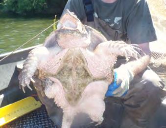
4 Results Fish Results: A total of nine fish species were sampled in Parkers Lake on July 2324, Bluegill and pumpkinseed sunfish were the most abundant species followed by yellow bullheads. Nets 2 and 6, were the most productive (Table 1). The number of yellow bullheads caught per net was above the normal range with a haul of 13.2 fish per net (Table 1). In addition, pumpkinseed and green sunfish were found at above average numbers for a typical range for a lake like Parkers, as defined by the MnDNR. Only one Largemouth bass was captured throughout sampling, resulting in a catchpernet less than the MnDNR average. Bluegill sunfish and black Crappie abundance was found to be within the average ranges based on data compiled by the MnDNR. Seven northern pike where captured in trapnets throughout the sampling regime ranging in size from 15.5 inches to 28 inches. Turtle Results: Snapping turtles and painted turtles were also sampled in the trapnets and were common in Parkers Lake. Painted turtles and snapping turtles likely do well because there is a fair percentage of a natural shoreline area. Table 1. Parkers Lake trapnet results for the fish survey conducted in July Black bullhead (Ameiurus melas) Black crappies (Pomoxis nigromaculatus) Bluegill sunfish (Lepomis macrochirus) Green Sunfish (Lepomis cyanellus) Hybrid Sunfish (Lepomis sp ) Largemouth bass (Micropterus salmoides) Pumpkinseed sunfish (Lepomis gibbosus) Northern Pike (Esox lucius) Yellow bullheads (Ameiurus natalis) Fish Captured (July ) Net 1 Net 2 Net 3 Net 4 Net 5 Net 6 Day 1 Day 2 Day 1 Day 2 Day 1 Day 2 Day 1 Day 2 Day 1 Day 2 Day 1 Day 2 Total Catch Fish per Net (n=12) Normal Range (MnDNR) TOTAL FISH Turtles painted Turtles snapping Parkers Lake Fish Survey
5 Fish s: Fish lengths are shown in Figure 3 and Table 2. Bluegill sunfish lengths ranged from 3 inches up to 8 inches with a relatively even distribution. Green and hybrid sunfish although increasing their abundance since last being surveyed, still have a low average length. The black crappie lengths show a strong year class in the 78 inch range, a good sign. Yellow bullheads where large and could be acting a predator to youngoftheyear (yoy) fish. Northen Pike lengths ranged from inches. Figure 3. distribution of black crappies, yellow bullheads, and bluegill sunfish from the July 2013 survey in Parkers Lake. Figure 4. Northern pike was the dominant predator found in Parkers Lake in July Parkers Lake Fish Survey
6 Table 2. frequency of fish species (as total length) for the Parkers Lake fish survey. Size (inches) Black crappies Bluegills Green sunfish <3 12 (3%) 20 (44%) Hybrid sunfish Largemouth Bass Northern Pike Pumpkinseed 3 24 (5%) 4 (9%) 1 (2%) 5 (2%) (5%) 8 (18%) 2 (4%) 2 (1%) 4 64 (14%) 6 (13%) 1 (2%) 20 (7%) (10%) 3 (6%) 5 (10%) 25 (8%) 5 66 (14%) 2 (4%) 3 (6%) 33 (11%) (3%) 49 (11%) 1 (2%) 11 (23%) 35 (12%) 6 1 (3%) 60 (13%) 1 (2%) 8 (16%) 70 (23%) Yellow Bullhead (6%) 49 (11%) 11 (23%) 48 (16%) 4 (3%) 7 8 (22%) 45 (10%) 1 (2%) 6 (12%) 49 (16%) 7 (4%) (19%) 15 (3%) 9 (3%) 9 (6%) 8 12 (33%) 5 (1%) 3 (1%) 8 (5%) (3%) 3 (2%) 9 4 (11%) 11 (7%) (6%) (11%) (7%) (18%) (6%) (13%) (8%) 13 5 (3%) (14%) 16 1 (14%) (100%) 1 (14%) (14%) 25 1 (14%) (14%) 28 1 (14%) Number of fish caught Parkers Lake Fish Survey
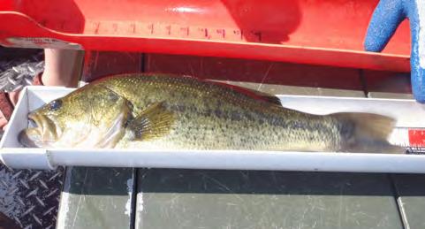
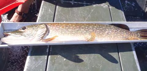
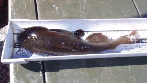
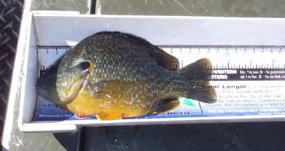
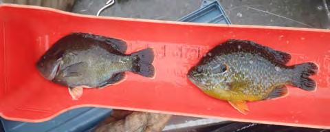
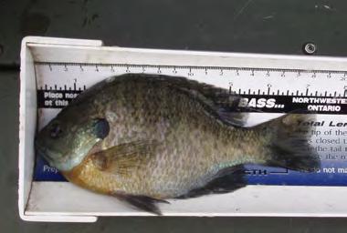
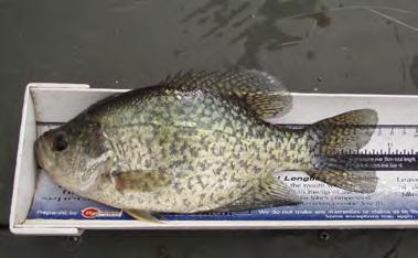
7 Representative Fish Species of Parkers Lake Largemouth Bass Northern Pike Bluegill Yellow Bullhead Hybrid Sunfish (left) and Pumpkinseed (right) Pumpkinseed Black Crappie Snapping Turtle Parkers Lake Fish Survey

8 Comparison of 2007 Survey to the 2013 Survey for Parkers Lake Parkers Lake was last surveyed in Both surveys (2007 and 2013) are shown in Table 3. Minor shifts may have occurred over the last 20 years. Bluegill abundance has decreased since 2007, while yellow bullhead and pumpkinseeds sunfish have seen a increase in abundance. Northen Pike, the main predator fish in Parkers lake, sampled well in the trapnet (2013) and appear to be maintaining good size distribution. Table 3. Historical trapnet fish survey records. Fish per net 2007 (MnDNR) Trapnet Results Fish per Net (n=12) 2013 (BWS) Normal Range (MnDNR) Black Crappie Bluegills Black Bullhead Green sunfish Hybrid Sunfish Largemouth bass Northern pike (Trapnet) Northern pike (Gillnet) Pumpkinseed Yellow Bullhead Turtles painted 1.5 Turtles snapping 0.9 TOTAL FISH Number of Fish Species 8 9 Figure 5. Bluegill densities have changed significantly between 2007 and Parkers Lake Fish Survey

9 Discussion General Findings In This Survey: Parkers Lake has the potential for good panfish fishing based on the size of black crappies and the number of bluegills found in this survey. For some reason, pumpkinseed sunfish are found in numbers above the regional range. Adult yellow bullheads had a range of lengths with the 10 to 12inch length the most common. Adult bullheads were probably not stunted since a community dominated by 68inch bullheads are typically associated with stunting. The top predator in Parkers Lake is the northern pike. However, additional predation pressure is likely applied to young fish by crappies and yellow bullheads. Figure 6. Net results from one net sampled in Parkers Lake in July Parkers Lake Fish Survey

10 Discussion concluded Gamefish Control to Prevent Bluegill Stunting: The existing top predator of the fish community in Parkers Lake is the northern pike. To prevent the development of stunted sunfish and bullhead populations predation pressure is essential. Based on theoretical piscivore lengths and converting fish length to gape width (Figure 8) it appears that the northern pike lengths in Parkers Lake, when converted to gape widths, will likely exert some predation pressure to prevent stunted bluegill (typical around 4inches) or yellow bullhead populations. Figure 7. Gamefish (piscivores) usually select prey that can be swallowed, which is a function of the piscivore gape verses the prey body depth. This 24inch northern pike from White Bear Lake made a mistake. It attempted to ingest a seven inch bluegill. The 24inch pike has a 2.0 inch gape, but a 7inch bluegill has a body depth of 2.3 inches. This pike was found floating and basically choked on the bluegill. Figure 8. Gamefish gape increases as a function of it s total length. The gape determines the size of the prey fish that can be swallowed. For example, a 4inch bluegill has a body depth of 1.5 inches. To ingest a 4inch bluegill it would take a 12inch bass that has a gape of 1.5 inches. There are few bass in Parkers Lake that could ingest a 4inch bluegills. Parkers Lake Fish Survey

11 Conclusions and Recommendations The trapnet survey in 2013 found the fish community was composed of nine species. The crappie and bluegill abundance were average for trapnet catches. Green sunfish, pumpkinseed sunfish, and yellow bullheads were above average in abundance. Recommendations and future considerations include the following: The young fish should produce an adequate a forage base on an annual basis. The carrying capacity of Parkers Lake will likely be established naturally which is a good longterm management strategy. Stocking adult largemouth bass could possibly help control bluegills and add to the sport fishery. However, at the present time, fish do not appear to be adversely impacting water quality and northern pike are found in high abundance. In four to five years another fish survey should be conducted to evaluate conditions and reevaluate recommendations. Figure 9. Three northern pike sampled on July 23, 2013 in Parkers Lake. Parkers Lake Fish Survey
12 Appendix A Minnesota DNR Fish Survey Notification Parkers Lake Fish Survey
13 Appendix B Minnesota DNR Fish Survey 2007 Parkers Lake Fish Survey
14 Minnesota Department of Natural Resources Fisheries Management STANDARD LAKE SURVEY REPORT Lake Name: Parkers Survey Type: Population Assessment DOW Number: Survey ID Date: 06/11/2007 Lake Identification Alternate Lake Name: N/A Primary Lake Class ID: 30 DNR Sounding Map Number: C1342 Alternate Lake Class ID: N/A Lake Location Primary County: Hennepin Nearest Town: Plymouth Legal Descriptions Lake Center: Township 118N Range 22W Section 28 PLS Section Lake Center: All Legal Descriptions: Hennepin County: Township 118N Range 22W Sections 28, 33 Area Office Area Name: Region Name: Metro West Central ORG Code: Region Number: F314 3 Lake Access (Information based on ReSurvey dated 06/05/1995) Station ID Ownership Public Use Type Location / Comments Lake Characteristics Lake Area (planimetered acres): GIS Lake Area (acres): DOW Lake Area (acres): Littoral Area (acres): Area in MN (acres): Maximum Depth (feet): 37.0 Mean Depth (feet): 12.0 (Data excludes records where public use is not designated or is designated "No Public Use") GIS Shoreline (miles): Maximum Fetch (miles): Fetch Orientation (degrees): USGS Quad Map Number: S16b USGS Quad 24K GIS Index: 3631 Watershed Characteristics Major Watershed Name: Mississippi RiverTC Watershed Number: 20 Watershed size (acres): 644,320 Minor Watershed Name: unknown DNR Minor Wshd Watershed Number: 97 Watershed size (acres): 6,472 Standard Lake Survey Report revision: 04/05/2011. Data Date: 12/16/2013 at 2:28 pm.
15 Surveys And Investigations STANDARD LAKE SURVEY REPORT POPULATION ASSESSMENT DATED 06/11/2007 FOR DOW NUMBER Initial Survey: 08/07/1975. ReSurvey: 06/05/1995, 06/10/1985. Population Assessment: 06/11/2007, 06/12/2001, 06/10/1991, 06/23/1980. Dissolved Oxygen And Temperature Profile Of Lake Water Station ID Sampling Date Bottom Depth (Feet) Sample Depth (Feet) Water Temperature ( F) Dissolved Oxygen (ppm) WQ 1 06/11/ Surface Field Measurements Of Water Quality Station ID Sampling Date Sample Depth (Feet) Secchi Depth (Feet) Field Alkalinity ph (ppm) Water Color Color Cause WQ 1 06/11/2007 Surface 11.5 N\A N/A Lt Brown N/A Color Description: Tanic Staind Laboratory Analysis Of Water Chemistry Station ID Sampling Date Analysis Date Sample Depth (ft) Chemical Parameter Chemical Value WQ 1 06/11/ /13/2007 Surface Total phosphorus ppm Total alkalinity 110 ppm Total dissolved solids 380 ppm Chlorophylla trichromatic method calculation 8.2 ppb Conductivity 688 :S/cm ph 8.65 ph 2
16 Net Catch Summary by Numbers for GN Standard gill net sets STANDARD LAKE SURVEY REPORT POPULATION ASSESSMENT DATED 06/11/2007 FOR DOW NUMBER Number of Sets: 6 First Set Date: 06/11/2007 Last Lift Date: 06/14/2007 Target Species: N/A Abbr Species Quartiles for Lake Class 30* Total Fish Number Per Set 25% 50% 75% BLC Black Crappie 8 BLG Bluegill 118 NOP Northern Pike 121 YEB Yellow Bullhead N/A N/A N/A Total Fish/Set: * Quartiles for Number Per Set Net Catch Summary by Weight for GN Standard gill net sets Abbr Species Total Weight (Pounds) Pounds Per Set Mean Quartiles for Lake Class 30* Weight 25% 50% 75% BLC BLG NOP YEB Black Crappie Bluegill Northern Pike Yellow Bullhead N/A N/A N/A Total Pounds Fish/Set: * Quartiles for Mean Weight 3
17 Net Catch Summary by Numbers for TN Standard 3/4in mesh, double frame trap net sets STANDARD LAKE SURVEY REPORT POPULATION ASSESSMENT DATED 06/11/2007 FOR DOW NUMBER Number of Sets: 8 First Set Date: 06/11/2007 Last Lift Date: 06/14/2007 Target Species: N/A Abbr Species Quartiles for Lake Class 30* Total Fish Number Per Set 25% 50% 75% BLG Bluegill 2,497 GSF Green Sunfish 7 HSF Hybrid Sunfish 25 LMB Largemouth Bass 1 NOP Northern Pike 2 PMK Pumpkinseed 3 YEB Yellow Bullhead N/A N/A N/A N/A N/A N/A Total Fish/Set: * Quartiles for Number Per Set Net Catch Summary by Weight for TN Standard 3/4in mesh, double frame trap net sets Abbr Species Total Weight (Pounds) Pounds Per Set Mean Quartiles for Lake Class 30* Weight 25% 50% 75% BLG GSF HSF LMB NOP PMK YEB Bluegill Green Sunfish Hybrid Sunfish Largemouth Bass Northern Pike Pumpkinseed Yellow Bullhead N/A 0.15 N/A N/A 0.36 N/A N/A 1.13 N/A Total Pounds Fish/Set: * Quartiles for Mean Weight 4
18 Frequency Distribution For GN STANDARD LAKE SURVEY REPORT POPULATION ASSESSMENT DATED 06/11/2007 FOR DOW NUMBER Standard gill net sets (Field work conducted between 06/11/2007 and 06/14/2007) BLC BLG NOP YEB < = > Total Min. Max. Mean # Measured No s for BLC BLG NOP YEB Note: Unless all fish were measured in the catch, totals shown for some lengthfrequency distributions may differ from the total number of fish in the catch, due to rounding of fractions used in the estimation of length frequency from a subsample of measured fish. 5
19 Frequency Distribution For TN STANDARD LAKE SURVEY REPORT POPULATION ASSESSMENT DATED 06/11/2007 FOR DOW NUMBER Standard 3/4in mesh, double frame trap net sets (Field work conducted between 06/11/2007 and 06/14/2007) BLG GSF HSF LMB NOP PMK YEB < = > Total Min. Max. Mean # Measured No s for BLG GSF HSF LMB NOP PMK YEB Note: Unless all fish were measured in the catch, totals shown for some lengthfrequency distributions may differ from the total number of fish in the catch, due to rounding of fractions used in the estimation of length frequency from a subsample of measured fish. 6
20 At Capture With Last Incremental STANDARD LAKE SURVEY REPORT POPULATION ASSESSMENT DATED 06/11/2007 FOR DOW NUMBER (BodyScale constant, all lengths, and all length increments in inches) Species: Black Crappie BodyScale Constant: 0.79 Total Sample Size: 8 at Capture in 2007 for Each Age Class, with Incremental s for 2007 Year Class Age Sampl esize Average At Capture Maximum Minimum Standard Error Increments Standard Increment Error N/A 0.41 N/A N/A 0.31 N/A Species: Bluegill BodyScale Constant: 0.79 Total Sample Size: 61 at Capture in 2007 for Each Age Class, with Incremental s for 2007 Year Class Age Sampl esize Average At Capture Maximum Minimum Standard Error Increments Standard Increment Error Species: Largemouth Bass BodyScale Constant: 0.79 Total Sample Size: 1 at Capture in 2007 for Each Age Class, with Incremental s for 2007 Year Class Age Sampl esize Average At Capture Maximum Minimum Standard Error Increments Standard Increment Error N/A 0.83 N/A 7
21 STANDARD LAKE SURVEY REPORT POPULATION ASSESSMENT DATED 06/11/2007 FOR DOW NUMBER At Capture With Last Incremental (Continued) Species: Northern Pike BodyScale Constant: 2.09 Total Sample Size: 101 at Capture in 2007 for Each Age Class, with Incremental s for 2007 Year Class Age Sampl esize Average At Capture Maximum Minimum Standard Error Increments Standard Increment Error Species: Pumpkinseed BodyScale Constant: 0.98 Total Sample Size: 3 at Capture in 2007 for Each Age Class, with Incremental s for 2007 Year Class Age Sampl esize Average At Capture Maximum Minimum Standard Error Increments Standard Increment Error N/A 0.81 N/A
22 STANDARD LAKE SURVEY REPORT POPULATION ASSESSMENT DATED 06/11/2007 FOR DOW NUMBER BackCalculated s for Each Age Class and Average Annual Increments of BackCalculated s Species: Black Crappie Gear Type: Combined Gear Types (GN) Class Age N Mean Mean Increment Total N Species: Bluegill Gear Type: Combined Gear Types (GN and TN) Class Age N Mean Mean Increment Total N Species: Largemouth Bass Gear Type: Combined Gear Types (TN) Class Age N Mean Mean Increment Total N
23 STANDARD LAKE SURVEY REPORT POPULATION ASSESSMENT DATED 06/11/2007 FOR DOW NUMBER BackCalculated s for Each Age Class and Average Annual Increments of BackCalculated s (Continued) Species: Northern Pike Gear Type: Combined Gear Types (GN and TN) Class Age N Mean Mean Increment Total N Species: Pumpkinseed Gear Type: Combined Gear Types (TN) Class Age N Mean Mean Increment Total N
24 Age Class Frequency Distribution STANDARD LAKE SURVEY REPORT POPULATION ASSESSMENT DATED 06/11/2007 FOR DOW NUMBER Species and Number of Fish (2) Gear (1) Aged Keyed Unaged Number of Fish in Year Class ('yy) and Age Class '07 '06 '05 '04 '03 '02 '01 '00 '99 '98 '97 '96 '95 '94 '93 <' Black Crappie GN Bluegill GN TN Totals: Largemouth Bass TN Northern Pike GN TN Totals: Pumpkinseed TN (1) Key to sampling gear abbreviations: GN = Standard gill net sets TN = Standard 3/4in mesh, double frame trap net sets (2) Notes: Number of Fish Aged: Fish that were aged from bony parts. Number of Fish Keyed: Fish assigned an age with an agelength key or by expansion of mesh or station age distributions. Number of Fish Unaged: Fish that were not aged and were not assigned an age. Other Species Gear Type (1) Other Species (Gender) (2) Total Num Number Measured (inches) Min Mean Max Number Weighed Weight (pounds) Min Mean Max TN Painted Turtle 3 0 N/A 0 N/A Snapping Turtle 3 0 N/A 0 N/A (1) Key to sampling gear abbreviations: TN = Standard 3/4in mesh, double frame trap net sets (2) Gender: If identified and reported. 11
25 STANDARD LAKE SURVEY REPORT POPULATION ASSESSMENT DATED 06/11/2007 FOR DOW NUMBER Survey Crew Notes null Area Signed by user 'mihabrat' on 06/05/2008 Area Signed by user 'Daelliso' on 06/05/2008 Area Signed by user 'Daelliso' on 08/07/2008 Region Signed by user 'Damccorm' on 08/08/2008 Field Notes General Field Crew leader: Mike Habrat Crew member: Chris Longhenry Report prepared by: Chris Longhenry Discussion Parkers Lake is a 97acre, class 30 lake within the city of Plymouth. Boat access to the lake is through a city maintained concrete boat ramp on the north end of the lake and shore access is available from a public fishing pier located on the west side of the lake. Northern pike and bluegill were the most abundant game fish during this survey but largemouth bass are also an important game fish in this lake. Northern pike index of abundance is at an all time high for Parkers Lake. Gill nets averaged 20.2 northern pike per net, which is approximately three times the third quartile for this lake class. Mean weight (2.7 pounds) was between the median and third quartiles. s ranged from 17.7 to 32 inches and averaged 22.6 inches. The size structure of this population includes a large number of fish between 20 and 25 inches (PSD = 73) and few fish exceeding 28 inches (RSD28 = 8). Even with the noted increase in abundance, growth is very similar to previous surveys and is average for class 30 lakes in this area. Aging analysis indicated six age classes are present (2 through 7) with ages 3, 4, and 5 accounting for 88 percent of the total population. Bluegill trap net catches (312.1 per net) were very high compared with similar lakes (third quartile = 59.6 per net). Similar to northern pike, this marks the highest bluegill abundance for Parkers Lake. These fish tend to be small, averaging 5.3 inches and 0.1 pounds. Only 25 percent of the population is longer than 6 inches and no fish greater than 8 inches were sampled. Growth was approximately average for this lake class and 7 age classes between 2 and 8 were present in the sample. Ages 3 and 5 were especially strong age classes and make up 58 percent of the total fish sampled. Black crappie were sampled below the first gill net quartile for abundance (1.3 per net) and has been below the normal range since Sampled black crappies ranged from 6.4 to 8.5 inches and averaged 7.4 inches. Four age classes (3 6) were present and growth was below the area average for class 30 lakes. Largemouth bass were not targeted during this survey, however one threeyearold bass was sampled that measured 7.2 inches and weighed 0.2 pounds. Yellow bullhead were sampled at or above the third quartile for abundance and mean weight for both trap (5 per net; 0.8 pounds) and gill nets (8 per net; 0.8 pounds). s ranged from 5.9 to 13.6 and averaged 11 inches. Other species sampled during this survey include pumpkinseed, hybrid, and green sunfish (0.4, 3.1, and 0.9 per trap net, respectively), however, abundance is low and sizes are small (mean lengths are 4.4, 6.0, and 4.1 inches for the respective species). 12
26 STANDARD LAKE SURVEY REPORT POPULATION ASSESSMENT DATED 06/11/2007 FOR DOW NUMBER Status Of The Fishery Parkers Lake is a 97acre, class 30 lake within the city of Plymouth. Boat access to the lake is through a city maintained concrete boat ramp on the north end of the lake and shore access is available from a public fishing pier located on the west side of the lake. Northern pike and bluegill were the most abundant game fish during this survey but largemouth bass are also an important game fish in this lake. Northern pike abundance is at an all time high for Parkers Lake. Gill nets averaged 20.2 northern pike per net, and mean weight was 2.7 pounds. s ranged from 17.7 to 32 inches and averaged 22.6 inches. The size structure of this population includes a large number of fish between 20 and 25 inches and 8 percent of the population is longer than 28 inches. Bluegill trap net catches (312.1 per net) were very high compared with similar lakes. Similar to northern pike, this marks the highest bluegill abundance for Parkers Lake. These fish tend to be small, averaging 5.3 inches and 0.1 pounds. Only 25 percent of the population is longer than 6 inches and no fish greater than 8 inches were sampled. Other sunfish species sampled during this survey include pumpkinseed, hybrid, and green sunfish, however abundance is low and sizes are small (mean lengths are 4.4, 6.0, and 4.1 inches for the respective species). Black crappie were sampled in below average numbers (1.3 per net) and have been below the normal range since Sampled black crappies ranged from 6.4 to 8.5 inches and averaged 7.4 inches. Largemouth bass were not targeted during this survey, however one threeyearold bass was sampled that measured 7.2 inches and weighed 0.2 pounds. Yellow bullhead were at above average density and weight (average weight = 0.8 pound). s ranged from 5.9 to 13.6 and averaged 11 inches. 13
27 Approval Dates And Notices STANDARD LAKE SURVEY REPORT POPULATION ASSESSMENT DATED 06/11/2007 FOR DOW NUMBER Date Approved By Metro West Area Fisheries Supervisor: Date Approved By Central Region Fisheries Manager: 08/07/ /08/2008 Copyright 2008, Minnesota Department of Natural Resources By accepting the data in this report, the user agrees the data will be used for personal benefit and not for profit. Any other uses or publication of the data needs the consent of the Department. The Minnesota Department of Natural Resources assumes no responsibility for actual or consequential damage incurred as a result of any user's reliance on the data. Standard Lake Survey Report revision: 04/05/2011RJE. Data Date: 12/16/2013 at 2:28 pm. 14
28 REPORT OVERVIEW FOR OFFICE USE ONLY (This page is not part of the Standard Lake Survey Report and should be discarded ) Lake Name: Parkers DOW Number: Survey Type: Population Assessment Survey ID Date: 06/11/2007 Survey Status: Region Signed The following 17 (of 31) report components are not included in this report: 1. Current Water Level 2. Benchmark And Gauge Descriptions / Locations 3. Water Level History* 4. Water Level History Readings* 5. Water Level History Station Summary* 6. Lake Inlets 7. Additional Inlet Information 8. Lake Outlets 9. Additional Outlet Information 10. Water Control Structure (Dam) 11. Surrounding Watershed Characteristics, Shoreline Characteristics, and Riparian Landscape Observations 12. Resorts And Campgrounds 13. Fish Spawning Conditions 14. Erosion And Pollution 15. Fish Diseases And Parasites 16. Aquatic Vegetation And Shoalwater Substrates 17. Water Quality (Winter Observations) (added to revision 01/21/2010) * Water Level History report: This data has not yet been migrated into the Fisheries LSM database. On 01/08/2009, two additional Water Level History report components (Readings and Station Summary) were added. Note: The data source for and Age Class Frequency Distribution tables is updated twice daily once at noon and once overnight. Any changes to the data made after noon on 12/16/2013 may not be reflected in the Distribution tables until 12/17/2013. The following survey component was flagged to be specifically excluded from this report: TN 6 Fisheries Lake ID = 3130, Survey ID = Standard Lake Survey Report revision: 04/05/2011. Data Date: 12/16/2013 at 2:28 pm.
Minnesota Department of Natural Resources
 Minnesota Department of Natural Resources Fisheries Management DRAFT VERSION - PRELIMINARY DATA (AS OF 7/7/) Lake Name: Bloody Survey Type: Standard Survey DOW Number: -4- Survey ID Date: 7// Lake Identification
LAKE SURVEY REPORT DRAFT VERSION PRELIMINARY DATA (AS OF 08/30/2018) Fisheries Management. DOW Number: Survey ID Date: 08/27/2018
 Fisheries Management. DOW Number: Survey ID Date: 08/27/2018") Fisheries Management DRAFT VERSION PRELIMINARY DATA (AS OF 8/3/218) Lake Name: Wilmert (main bay) Survey Type: Standard Survey DOW Number: 6-1-1 Survey ID Date: 8/27/218 Lake Identification Alternate Lake
Fisheries Management DRAFT VERSION PRELIMINARY DATA (AS OF 8/3/218) Lake Name: Wilmert (main bay) Survey Type: Standard Survey DOW Number: 6-1-1 Survey ID Date: 8/27/218 Lake Identification Alternate Lake
LAKE SURVEY REPORT DRAFT VERSION PRELIMINARY DATA (AS OF 08/24/2018) Fisheries Management. DOW Number: Survey ID Date: 08/21/2018
 Fisheries Management. DOW Number: Survey ID Date: 08/21/2018") Fisheries Management DRAFT VERSION PRELIMINARY DATA (AS OF 8//8) Lake Name: Sisseton Survey Type: Standard Survey DOW Number: 6-- Survey ID Date: 8//8 Lake Identification Alternate Lake Name: Primary Lake
Fisheries Management DRAFT VERSION PRELIMINARY DATA (AS OF 8//8) Lake Name: Sisseton Survey Type: Standard Survey DOW Number: 6-- Survey ID Date: 8//8 Lake Identification Alternate Lake Name: Primary Lake
Minnesota Department of Natural Resources
 Minnesota Department of Natural Resources Fisheries Management Lake Name: Colby Survey Type: Population Assessment DOW Number: 699 Survey ID Date: 7// Lake Identification Alternate Lake Name: Partridge
Fish Survey of Goose Lake (ID # ), Ramsey County, Minnesota in 2012
, Ramsey County, Minnesota in 2012") Softshell Turtle from Goose Lake, July 2012 Fish Survey of Goose Lake (ID #62-0034), Ramsey County, Minnesota in 2012 Survey Dates: July 16-18, 2012 MnDNR Permit Number: 18362 Prepared for: VLAWMO and
Softshell Turtle from Goose Lake, July 2012 Fish Survey of Goose Lake (ID #62-0034), Ramsey County, Minnesota in 2012 Survey Dates: July 16-18, 2012 MnDNR Permit Number: 18362 Prepared for: VLAWMO and
Fish Survey of Arctic Lake (ID # ), Scott County, Minnesota in 2012
, Scott County, Minnesota in 2012") Snapping Turtle from Arctic Lake, September 2012 Fish Survey of Arctic Lake (ID #70-0085), Scott County, Minnesota in 2012 Survey Dates: September 18-20, 2012 MnDNR Permit Number: 18362 Prepared for: Shakopee
Snapping Turtle from Arctic Lake, September 2012 Fish Survey of Arctic Lake (ID #70-0085), Scott County, Minnesota in 2012 Survey Dates: September 18-20, 2012 MnDNR Permit Number: 18362 Prepared for: Shakopee
Inventory # Perch Lake
 Inventory # 9-036 Perch Lake Perch Lake is a double-basin lake. The southern, shallow portion of the lake is 414 acres, making it the largest wild rice lake on the Reservation. The fish communities sampled
LAKE DIANE Hillsdale County (T8-9S, R3W, Sections 34, 3, 4) Surveyed May Jeffrey J. Braunscheidel
 Surveyed May Jeffrey J. Braunscheidel") Michigan Department of Natural Resources Status of the Fishery Resource Report No. 2003-4, 2003 LAKE DIANE Hillsdale County (T8-9S, R3W, Sections 34, 3, 4) Surveyed May 2001 Jeffrey J. Braunscheidel Environment
Michigan Department of Natural Resources Status of the Fishery Resource Report No. 2003-4, 2003 LAKE DIANE Hillsdale County (T8-9S, R3W, Sections 34, 3, 4) Surveyed May 2001 Jeffrey J. Braunscheidel Environment
DOW# West Twin Lake
 DOW# 69-0696 West Twin Lake West Twin Lake has a surface area of 120.4 acres and is located on the east side of St. Louis County Road 31, south of Highway 2. West Twin Lake has a maximum depth of 18 feet
Lake information report
 Page of 5 Lake information report Name: Whitewater Nearest Town: Hoyt Lakes Primary County: St. Louis Survey Date: 08/3/2007 Inventory Number: 69037600 Public Access Information Ownership Type Description
Trapnet Fish Surveys for Sweeney Lake ( ) and Twin Lake ( ), Hennepin County, September 17-19, 2013
 and Twin Lake ( ), Hennepin County, September 17-19, 2013") Trapnet catch from Sweeney Lake, September 2013 Trapnet Fish Surveys for Sweeney Lake (27-0035-01) and Twin Lake (27-0035-02), Hennepin County, September 17-19, 2013 MnDNR Permit Number 19414 Submitted
Trapnet catch from Sweeney Lake, September 2013 Trapnet Fish Surveys for Sweeney Lake (27-0035-01) and Twin Lake (27-0035-02), Hennepin County, September 17-19, 2013 MnDNR Permit Number 19414 Submitted
NURSERY POND Fish Management Report. Jason C. Doll Assistant Fisheries Biologist
 NURSERY POND 2004 Fish Management Report Jason C. Doll Assistant Fisheries Biologist FISHERIES SECTION INDIANA DEPARTMENT OF NATURAL RESOURCES DIVISION OF FISH AND WILDLIFE I.G.C. South, Room W273 402
Lake information report
 Lake information report: Minnesota DNR Page of 5 Lake information report jf Prinlable senior Name: Spring Nearest Town: Spring Lake (Scott) Primary County: Scott Survey Date: 08/02/200 Inventory Number:
Current Status and Management Recommendations for the Fishery in the Cloverleaf Chain of Lakes
 Current Status and Management Recommendations for the Fishery in the Cloverleaf Chain of Lakes Jason Breeggemann Senior Fisheries Biologist Wisconsin Department of Natural Resources Outline DNR fisheries
MARTINDALE POND Wayne County 2004 Fish Management Report. Christopher C. Long Assistant Fisheries Biologist
 MARTINDALE POND Wayne County 2004 Fish Management Report Christopher C. Long Assistant Fisheries Biologist Fisheries Section Indiana Department of Natural Resources Division of Fish and Wildlife I.G.C.
Crooked Lake Oakland County (T4N, R9E, Sections 3, 4, 9) Surveyed May James T. Francis
 Surveyed May James T. Francis") Michigan Department of Natural Resources Status of the Fishery Resource Report No. 2004-1, 2004 Crooked Lake Oakland County (T4N, R9E, Sections 3, 4, 9) Surveyed May 2002 James T. Francis Environment Crooked
Michigan Department of Natural Resources Status of the Fishery Resource Report No. 2004-1, 2004 Crooked Lake Oakland County (T4N, R9E, Sections 3, 4, 9) Surveyed May 2002 James T. Francis Environment Crooked
LITTLE WHITE OAK Knox County 2006 Fish Management Report. Debbie King Assistant Fisheries Biologist
 LITTLE WHITE OAK Knox County 2006 Fish Management Report Debbie King Assistant Fisheries Biologist Fisheries Section Indiana Department of Natural Resources Division of Fish and Wildlife I.G.C.-South,
MEMORANDUM Comfort Lake-Forest Lake Watershed District
 MEMORANDUM Comfort Lake-Forest Lake Watershed District To: Board of Managers Date: December 7, 2016 From: Mike Kinney Subject: 2016 Watercraft Inspections and AIS Report Summaries Watercraft Inspection
LAKE MANAGEMENT PLAN
 LAKE MANAGEMENT PLAN Region Area DOW Number County DOW Lake Name Acreage 2 Duluth F213 69-0041 St. Louis Bassett DOW: 436 Plan: 442 Long Range Goal: Manage for walleye with a gillnet catch rate greater
Michigan Department of Natural Resources Status of the Fishery Resource Report Page 1
 Michigan Department of Natural Resources 2007-33 Status of the Fishery Resource Report Page 1 Grand Sable Lake Alger County, T49N, R14W, Sec. Many Lake Superior watershed, last year surveyed 2004 James
I Region I Area I DOW Number / County I DOW Lake Name I Acreage I
 LAKE MANAGEMENT PLAN 814 Bp I Region I Area I DOW Number / County I DOW Lake Name I Acreage I I I # I f 2 Duluth F213 690036 St Louis Salo DOW:149 Plan: 137 Long Range Goal: Manage for walleye with a gillnet
Michigan Dept. of Natural Resources Status of the Fishery Resource Report Page 1. Weber Lake Cheboygan County, T34N, R3W, Sec.
 Michigan Dept. of Natural Resources 2012-143 Status of the Fishery Resource Report Page 1 Weber Lake Cheboygan County, T34N, R3W, Sec. 31 Neal Godby, Fisheries Biologist Environment Weber Lake is a 28.5-acre
BIG TWIN LAKE Kalkaska County (T28N, R05W, Section 18, and T28N, R06W, Section 13) Surveyed May 1999
 Surveyed May 1999") Michigan Department of Natural Resources Status of the Fishery Resource Report No. 2001-1, Year 2001 BIG TWIN LAKE Kalkaska County (T28N, R05W, Section 18, and T28N, R06W, Section 13) Surveyed May 1999
Michigan Department of Natural Resources Status of the Fishery Resource Report No. 2001-1, Year 2001 BIG TWIN LAKE Kalkaska County (T28N, R05W, Section 18, and T28N, R06W, Section 13) Surveyed May 1999
Fisheries Survey of White Rapids Flowage, Marinette County Wisconsin during Waterbody Identification Code
 Fisheries Survey of White Rapids Flowage, Marinette County Wisconsin during 25 Waterbody Identification Code 6343 Michael Donofrio Fisheries Supervisor Wisconsin Department of Natural Resources Peshtigo,
JadEco, LLC PO BOX 445 Shannon, IL 61078
 Introduction: With the assistance of Lake Holiday staff and volunteers, we were able to conduct an AC electrofishing survey on May 8, 27. Water temperatures were 2.3 C (8.5 F) and water clarity was decent
KICKAPOO LAKE Shakamak State Park Sullivan, Greene, and Clay Counties 2009 Fish Management Report. David S. Kittaka Fisheries Biologist
 KICKAPOO LAKE Shakamak State Park Sullivan, Greene, and Clay Counties 2009 Fish Management Report David S. Kittaka Fisheries Biologist Fisheries Section Indiana Department of Natural Resources Division
MIDDLE FORK RESERVOIR Wayne County 2006 Fish Management Report. Christopher C. Long Assistant Fisheries Biologist
 MIDDLE FORK RESERVOIR Wayne County 2006 Fish Management Report Christopher C. Long Assistant Fisheries Biologist Fisheries Section Indiana Department of Natural Resources Division of Fish and Wildlife
MINNESOTA DEPARTMENT OF NATURAL RESOURCES DIVISION OF FISHERIES AND WILDLIFE. Gamefish Assessment Report
 Minnesota DNR F-29-R(P) Area F312 February 1, 2013 MINNESOTA DEPARTMENT OF NATURAL RESOURCES DIVISION OF FISHERIES AND WILDLIFE Gamefish Assessment Report Spring Gamefish Assessment on the Mississippi
An Assessment of the Fish Community in Lake Acworth
 An Assessment of the Fish Community in Lake Acworth By John Damer Fisheries Biologist Georgia Department of Natural Resources Wildlife Resources Division Fisheries Section Calhoun, GA 30701 July 2008 Introduction
Quemahoning Reservoir
 Pennsylvania Fish & Boat Commission Biologist Report Quemahoning Reservoir Somerset County May 2011 Trap Net, Gill Net and Electrofishing Survey Quemahoning Reservoir is an 899 acre impoundment located
Big Bend Lake Population Survey
 Big Bend Lake Survey Located in Des Plaines on East River Rd. just south of Golf Rd. This 27 acre body of water has a depth of 27.8 feet; however because it is connected to the Des Plaines River by a spillway,
MIDDLE FORK RESERVOIR Wayne County 2004 Fish Management Report. Christopher C. Long Assistant Fisheries Biologist
 MIDDLE FORK RESERVOIR Wayne County 2004 Fish Management Report Christopher C. Long Assistant Fisheries Biologist FISHERIES SECTION INDIANA DEPARTMENT OF NATURAL RESOURCES DIVISION OF FISH AND WILDLIFE
Penny Road Pond Population Survey
 Located in Barrington Hills on the south side of Penny Rd. west of Old Sutton Rd. This small 7 acre pond has a maximum depth of 4.6 feet and is connected to Spring Creek. The fish population of Penny Road
LAKE MANAGEMENT PLAN
 LAKE MANAGEMENT PLAN Region 1 Area Park Rapids D.O.W. Number 29-185 County Hubbard D.O.W. Lake Name Big Sand Lake Class 22 Acreage 1,635 GIS 465 littoral LONG RANGE GOALS: Maintain or improve the quality
Cedar Lake Comprehensive Survey Report Steve Hogler and Steve Surendonk WDNR-Mishicot
 Cedar Lake- 2006 Comprehensive Survey Report Steve Hogler and Steve Surendonk WDNR-Mishicot ABSTRACT Cedar Lake is a 142 acre lake located in the southwest corner of Manitowoc County. It is a seepage lake
Status Review and Management Outline for Quality Bluegill and Black Crappie Populations in the Grand Rapids Area.
 Status Review and Management Outline for Quality Bluegill and Black Crappie Populations in the Grand Rapids Area. Revised in 2013 By David L. Weitzel Assistant Area Fisheries Supervisor MN DNR, Grand Rapids
Lake information report
 Page 1 of 6 Lake information report Name: Saganaga Nearest Town: Grand Marais Primary County: Cook Survey Date: 08/08/2011 Inventory Number: 16063300 walleye stocking. Purchase a walleye stamp. Your voluntary
Minnesota Department of Natural Resources Division of Fisheries and Wildlife
 Minnesota Department of Natural Resources Division of Fisheries and Wildlife Completion Report Evaluation of Centrarchid Populations throughout Leech Lake 215 by Matt Ward Walker Area Fisheries Office
Tampier Lake Population Survey
 Located in Palos Park on 131 st St. between Wolf and Will-Cook Rd. s. Tampier Lake has 131 acres of fishable water, with a maximum depth of 9.4 feet. Walleye, northern pike, largemouth bass and channel
2014 Island Lake Survey June 13 th, 2014 Andrew Plauck District Fisheries Biologist Report Prepared 4 March 2015
 2014 Island Lake Survey June 13 th, 2014 Andrew Plauck District Fisheries Biologist Report Prepared 4 March 2015 BACKGROUND - A fish survey was requested due to a moderately severe winterkill in Island
LAKE PLEASANT Steuben County 2006 Fish Management Report. Larry A. Koza Assistant Fisheries Biologist
 LAKE PLEASANT Steuben County 2006 Fish Management Report Larry A. Koza Assistant Fisheries Biologist Fisheries Section Indiana Department of Natural Resources Division of Fish and Wildlife I.G.C.-South,
NEW OAKLAND CITY LAKE Gibson County 2007 Fish Management Report. Michelle L. Weinman Assistant Fisheries Biologist
 E OAKLAD CITY LAKE Gibson County 2007 Fish Management Report Michelle L. einman Assistant Fisheries Biologist Fisheries Section Indiana Department of atural Resources Division of Fish and ildlife I. G.
Alcona Dam Pond Alcona County (T25N, R5E, Sections various) Surveyed June 6-12 and September 16, 2003
 Surveyed June 6-12 and September 16, 2003") Michigan Department of Natural Resources Status of the Fishery Resource Report No. 2004-6, Year 2004 Alcona Dam Pond Alcona County (T25N, R5E, Sections various) Surveyed June 6-12 and September 16, 2003
Michigan Department of Natural Resources Status of the Fishery Resource Report No. 2004-6, Year 2004 Alcona Dam Pond Alcona County (T25N, R5E, Sections various) Surveyed June 6-12 and September 16, 2003
Pennsylvania Fish & Boat Commission Biologist Report. Wilmore Dam. Cambria County. May 2011 Trap Net, Electrofishing and Hoop Net Survey
 Pennsylvania Fish & Boat Commission Biologist Report Wilmore Dam Cambria County May 2011 Trap Net, Electrofishing and Hoop Net Survey Wilmore Dam is a 195 acre impoundment located in central Cambria County
Bode Lake - South Population Survey
 Bode Lake - South Survey Located in Hoffman Estates on the north side of Bode Rd. 1 mile west of Barrington Rd. Bode Lake is made up of two lakes along Poplar Creek; the larger and deeper Bode Lake South
Sag Quarry - West Population Survey
 Located in Lemont on RT 83 and Archer Ave. just north of 111 th St. Like Sag Quarry East, this lake is an old limestone quarry, 14 acres in size and with a maximum depth of 10.3 feet. The species found
Arizona Game and Fish Department Region VI Fisheries Program
 Arizona Game and Fish Department Region VI Fisheries Program Saguaro Lake Fish Survey Report April 18 th 21 st, 2016 Author: Bryant Dickens Report Date: July 7, 2016 The Arizona Game and Fish Department
Maple Lake Population Survey
 Maple Lake Survey Located in Willow Springs approximately 1 mile west of Willow Springs Rd. (104 th Ave.) at Wolf Rd. and 95 th St. Constructed in the 1920 s this 60 acre lake drops down to 20.4 feet in
CORRESPONDENCE/MEMORANDUM
 CORRESPONDENCE/MEMORANDUM State of Wisconsin DATE: November 13, 2012 FILE REF: [Click here and type file ref.] TO: FROM: Mike Donofrio Harpt Lake File Steve Hogler SUBJECT: 2012 Harpt Lake Electrofishing
Comprehensive Fisheries Survey of High Falls Reservoir, Marinette County Wisconsin during 2004 and Waterbody Identification Code
 Comprehensive Fisheries of High Falls Reservoir, Marinette County Wisconsin during 2004 and 2005 Waterbody Identification Code 540600 Justine Hasz Senior Fisheries Biologist Wisconsin Department of Natural
Archer Lake 2011 Survey Report Prepared by Brian Gunderman
 Archer Lake 211 Survey Report Prepared by Brian Gunderman Introduction Archer Lake is a 64 acre lake located about miles southeast of the city of Coldwater. Archer Lake is part of the Coldwater-Marble
Arrowhead Lake Population Survey
 Located in Palos Heights at 135 th St, east of Harlem Ave. Arrowhead Lake is a 13 acre body of water with a maximum depth of 12.6 feet. Fish species found in this lake include largemouth bass, bluegill,
Rolling Knolls Pond Population Survey
 Located near the town of Elgin on the west side of Rohrssen Rd. between Illinois Route 58 and U.S.- 20. This small 1.8 acre pond has a maximum depth of 7.5 feet and is occasionally influenced by Poplar
Busse Reservoir South Lateral Pool Population Survey
 Busse Reservoir South Lateral Pool Survey Located in Elk Grove Village south of Higgins Rd. between RT 53/I-290 and Arlington Heights Rd. Busse Reservoir is comprised of three pools making up a total of
Michigan Dept. of Natural Resources Status of the Fishery Resource Report Page 1
 Michigan Dept. of Natural Resources 2014-197 Status of the Fishery Resource Report Page 1 Otter Lake Lapeer and Genesee Counties, T9,10N/R8,9E/ Sections 1,6,7,36 Flint River Watershed, Last surveyed 2014
Green Lake Population Survey
 Located next to the Green Lake Aquatic Center in Calumet City on the north side of 159 th St, east of Torrence Ave. Size can be deceiving; this 5 acre lake is the deepest lake in the District with a maximum
Mark A. Tonello and Ralph L. Hay
 Michigan Department of Natural Resources Status of the Fishery Resource Report No. 2003-3, 2003 Fife Lake Grand Traverse County (T25N, R09W, Section 13) Surveyed June 4-8, 2001 Mark A. Tonello and Ralph
CARL BLACKWELL LAKE MANAGEMENT PLAN
 CARL BLACKWELL LAKE MANAGEMENT PLAN Background Lake Carl Blackwell impounds Stillwater Creek, 10 miles west of Stillwater in Payne County, Oklahoma (Figure 1). The lake covers 3,370 surface acres and was
WISCONSIN DEPARTMENT OF NATURAL RESOURCES FISH MANAGEMENT ACTIVITIES DELAVAN LAKE SPRING 2012
 WISCONSIN DEPARTMENT OF NATURAL RESOURCES FISH MANAGEMENT ACTIVITIES DELAVAN LAKE SPRING 212 Electrofishing and fyke net surveys were conducted on Delavan Lake March 2-May 3, 212. Fyke netting and electrofishing
Wampum Lake Population Survey
 Wampum Lake Survey Located in Thornton on Thornton-Lansing Rd. 1½ mile west of Torrence Ave. Wampum Lake is 35 acres is size and has a maximum depth of 14.1 feet. Northern pike, largemouth bass, bluegill,
Elk Lake, Antrim and Grand Traverse counties T. 28, 29 N., R. 8, 9 W., Sec. many. Lake surveys. began at 40 feet
 Elk Lake, Antrim and Grand Traverse counties T. 28, 29 N., R. 8, 9 W., Sec. many Physical and chemical data surveyed August 1931 Temperature ( F) Secchi disk (feet) 9. 6 Surface 74 Bottom 45 PH 8.0 Thermocline
Keystone Lakes November 20, 2014
 FISH SURVEY REPORT Keystone Lakes November 20, 2014 Prepared for: Keystone HOA 6231 Shoreham Drive Evansville, IN 47711 Prepared by: Aquatic Control Inc. P.O. Box 100 Seymour, IN 47274 November 2015 -
BEAVER DAM LAKE Kosciusko County 2005 Fish Management Report. Angela C. Benson Assistant Biologist
 BEAVER DAM LAKE Kosciusko County 2005 Fish Management Report Angela C. Benson Assistant Biologist Fisheries Section Indiana Department of Natural Resources Division of Fish and Wildlife I.G.C.-South, Room
Schiller Pond Population Survey
 Located in the town of Schiller Park on Irving Park Rd. just west of Cumberland Ave. This small 6 acre pond has a maximum depth of 6.3 feet. In addition to largemouth bass and bluegill, Schiller Pond is
Lake LeAnn 2018 Fish Survey
 Lake LeAnn 2018 Fish Survey June 21, 2018 Prepared for: Lake LeAnn Property Owners Association Prepared by: ADVANCED ECOLOGICAL MANAGEMENT 22071 7 Mile Road Reed City, MI 49677 Table of Contents 1.0 INTRODUCTION...
A SURVEY OF THE PRETTY LAKE FISH COMMUNITY, LARGEMOUTH BASS AND WALLEYE POPULATIONS AND FISH HARVEST LaGrange County 2010
 A SURVEY OF THE PRETTY LAKE FISH COMMUNITY, LARGEMOUTH BASS AND WALLEYE POPULATIONS AND FISH HARVEST LaGrange County 2010 Larry A. Koza Assistant Fisheries Biologist Fisheries Section Indiana Department
McGinty Slough Population Survey
 Located in Lemont, north of 131 st St and west of Will-Cook Rd. and is 38 acres with a depth of 8.2 feet. This lake is walk in access only, to access the lake walk the multi-use trail ether from 131 st
Aquatic Plant Point-Intercept Survey for Pike Lake, Scott County, Minnesota
 Campers on Pike Lake, Scott County, Minnesota, 2015 Aquatic Plant Point-Intercept Survey for Pike Lake, Scott County, Minnesota [Plant Survey Conducted August 24, 2015] Prepared for: Prior Lake/Spring
Caro Impoundment, Tuscola County
 Caro Impoundment is a 200 acre impoundment of the Cass River located one mile south of the Village of Caro in Tuscola County. Caro Dam, originally constructed in 1906 for water supply to Michigan Sugar
2011 Haha Lake Northern Pike Control
 2011 Haha Lake Northern Pike Control Prepared By: Christin Davis Ministry of Forests, Lands, and Natural Resource Operations #401-333 Victoria Street Nelson, BC V1L 4K3 Summary In 2005, northern pike (Esox
O Malley s Ponds Population Survey
 O Malley s Ponds Survey The newest fishing lake within the Forest Preserves of Cook County, O Malley Ponds were acquired by the District in 2005. Located in Sauk Village at the intersection of Sauk Trail
SKIATOOK LAKE MANAGEMENT PLAN
 SKIATOOK LAKE MANAGEMENT PLAN Background Skiatook Lake impounds Hominy Creek, 5 miles west of Skiatook in Osage County, Oklahoma (Figure 1). Skiatook Lake covers 10,540 surface acres and was constructed
7/29/2011. Sport fish. Rough fish. Fish Population Assessment
 Fish Population Assessment Sport fish Forage fish Rough fish 1 Question: How Do I Assess My Fish Population? Answer: Volkswagens to Corvettes!!! Volkswagen or Do-it-yourself Approach Keep catch records
2010 Fishing Opener Prognosis. Central Region
 2010 Fishing Opener Prognosis Central Region Hinckley PINE COUNTY Pokegama, Cross, Island, Oak and North and South Big Pine Lakes are typically the best lakes for targeting walleye in Pine County. They
Relative Size Selectivity of Trap Nets for Eight Species of Fish'
 North American Journal of Fisheries Management 2:33-37, 1982 Copyright by the American Fisheries Society 1982 Relative Size Selectivity of Trap Nets for Eight Species of Fish' PERCY W. LAARMAN AND JAMES
Introduction: JadEco, LLC PO BOX 445 Shannon, IL 61078
 Introduction: was contacted to collected data on the fishery for Lake Holiday. AC Electroshocking was conducted at 2 locations on September 28, 2015. Fish population data was collected for a total of 100
Comprehensive Fisheries Evaluation of Patten Lake, Florence County, Wisconsin 2011
 Comprehensive Fisheries Evaluation of Patten Lake, Florence County, Wisconsin 211 Water body Identification Code 6537 Gregory Matzke Fisheries Biologist Wisconsin Department of Natural Resources Florence
NEVADA DEPARTMENT OF WILDLIFE STATEWIDE SPORT FISHERIES MANAGEMENT
 NEVADA DEPARTMENT OF WILDLIFE STATEWIDE SPORT FISHERIES MANAGEMENT FEDERAL AID JOB PROGRESS REPORT F-20-50 2014 Urban Sport Fisheries SOUTHERN REGION NEVADA DEPARTMENT OF WILDLIFE, FISHERIES DIVISION ANNUAL
DRIPPING SPRINGS LAKE 5 YEAR LAKE MANAGEMENT PLAN
 DRIPPING SPRINGS LAKE 5 YEAR LAKE MANAGEMENT PLAN FISHERIES DIVISION CENTRAL REGION OKLAHOMA DEPTMENT OF WILDLIFE CONSERVATION PREPARED BY: DANNY BOWEN OCTOBER 2013 1 Background Dripping Springs Lake impounds
Proposed Changes to Bag and Size Limits Minnesota/Wisconsin Border Waters of the Mississippi River
 Proposed Changes to Bag and Size Limits Minnesota/Wisconsin Border Waters of the Mississippi River The Minnesota and Wisconsin DNRs are jointly reviewing fishing regulations on Pools 3-9 of the Mississippi
NEVADA DEPARTMENT OF WILDLIFE STATEWIDE FISHERIES MANAGEMENT
 NEVADA DEPARTMENT OF WILDLIFE STATEWIDE FISHERIES MANAGEMENT FEDERAL AID JOB PROGRESS REPORTS F-2-52 216 CHIMNEY RESERVOIR WESTERN REGION NEVADA DEPARTMENT OF WILDLIFE, FISHERIES DIVISION JOB PROGRESS
Comparative Survival of Pellet-Reared Muskellunge Stocked As Fingerlings In Bluegill Ponds With and Without Largemouth Bass
 1 9 2 0 Comparative Survival of Pellet-Reared Muskellunge Stocked As Fingerlings In Bluegill Ponds With and Without Largemouth Bass George B. Beyerle Fisheries Research Report No. 1920 April 23, 1984 MICHIGAN
BENSON PARK POND FISH SPECIES
 BENSON PARK POND FISH SPECIES Bluegill (Lepomis macrochirus) From the Greek, lepomis means scaled gill cover and macrochirus means large hand, in reference to its body shape and size. Average adult size
Michigan Dept. of Natural Resources and Environment Status of the Fishery Resource Report Page 1
 Status of the Fishery Resource Report Page 1 Avalon Lake Montmorency County Thunder Bay River watershed, last surveyed 2010 Tim A. Cwalinski, MDNR Senior Fisheries Biologist Environment Avalon Lake, formerly
SOONER LAKE MANAGEMENT PLAN
 SOONER LAKE MANAGEMENT PLAN Background Lake Sooner impounds Greasy Creek, 15 miles south of Ponca City in Noble and Pawnee Counties, Oklahoma (Figure 1). The Grease Creek basin that Sooner Lake impounds
HUBBARD LAKE Alcona County (T27N, R7E; T28N, R7E) Surveyed May and September Tim A. Cwalinski
 Surveyed May and September Tim A. Cwalinski") Michigan Department of Natural Resources Status of the Fishery Resource Report No. 2003-1, 2003 HUBBARD LAKE Alcona County (T27N, R7E; T28N, R7E) Surveyed May and September 1996 Tim A. Cwalinski Environment
Michigan Department of Natural Resources Status of the Fishery Resource Report No. 2003-1, 2003 HUBBARD LAKE Alcona County (T27N, R7E; T28N, R7E) Surveyed May and September 1996 Tim A. Cwalinski Environment
Crawford Reservoir. FISH SURVEY AND MANAGEMENT INFORMATION Eric Gardunio, Fish Biologist Montrose Service Center
 FISH SURVEY AND MANAGEMENT INFORMATION General Information: Crawford Reservoir is a popular fishery that provides angling opportunity for yellow perch, channel catfish, northern pike, rainbow trout, black
Fish Community. Fish Habitat, Streams and Rivers
 Clear, Ston(e)y and White Lake Plan Fish Community The lakes support a cool/warm water fishery including muskellunge, walleye, largemouth and smallmouth bass, yellow perch, pumpkinseed, rockbass, blue
Fall 2017: Problem Set 3 (DUE Oct 26; 50 points)
") ESS 445 Introduction to Fisheries Science and Management: Biology, Ecology, Management, and Conservation of North American Freshwater Fishes and Aquatic Ecosystems Fall 2017: Problem Set 3 (DUE Oct 26;
ESS 445 Introduction to Fisheries Science and Management: Biology, Ecology, Management, and Conservation of North American Freshwater Fishes and Aquatic Ecosystems Fall 2017: Problem Set 3 (DUE Oct 26;
Minnesota Department of Natural Resources Division of Fisheries and Wildlife. Winter Creel Survey Report for Leech Lake
 Minnesota F13AF00322 R29G60F29RP31 Segment 31-2 Study 4 Job 935 May 2015 Minnesota Department of Natural Resources Division of Fisheries and Wildlife Completion Report Winter Creel Survey Report for Leech
REEL FACTS. Regulations. Limblines Fishing with limblines and set hooks is prohibited at Lake Washington.
 Lake Washington 19 REEL FACTS Nathan Aycock Fisheries Biologist NathanA@mdwfp.state.ms.us (61) 432-2 General Information: Lake Washington is a 3, acre oxbow lake of the Mississippi River. It is one of
East Metro Forest Lake (2,251 acres): Coon Lake (1,481 acres):
: Coon Lake (1,481 acres):") East Metro Forest Lake (2,251 acres): Located within the City of Forest Lake and just east of Interstate 35, Forest Lake boasts good numbers of northern pike and walleye. Northern pike and walleye were
East Metro Forest Lake (2,251 acres): Located within the City of Forest Lake and just east of Interstate 35, Forest Lake boasts good numbers of northern pike and walleye. Northern pike and walleye were
Rock Creek Huntington County Supplemental Evaluation
 Rock Creek Huntington County Supplemental Evaluation Date of Survey: September 8 to September 10, 2008 Biologist: Rod A. Edgell Survey Objectives: Conduct population estimates for game fish at Rock Creek
Gamefish Assessment Report
 MINNESOTA DEPARTMENT OF NATURAL RESOURCES Gamefish Assessment Report Spring Gamefish Assessment on the Mississippi River from Little Falls to Brainerd, MN May 31 through June 4, 2013 River Miles 966 to
Spring Lake 2017 REEL FACTS Keith Meals Fisheries Biologist
 Spring Lake 217 REEL FACTS Keith Meals Fisheries Biologist keithm@mdwfp.state.ms.us General Information: Spring Lake is a clear, shallow 6 acre spring-fed impoundment in Wall Doxey State Park. Nearly half
NEVADA DEPARTMENT OF WILDLIFE STATEWIDE FISHERIES MANAGEMENT
 NEVADA DEPARTMENT OF WILDLIFE STATEWIDE FISHERIES MANAGEMENT FEDERAL AID JOB PROGRESS REPORTS F-2-49 213 RYE PATCH RESERVOIR WESTERN REGION NEVADA DEPARTMENT OF WILDLIFE, FISHERIES DIVISION ANNUAL PROGRESS
Waubee Lake Kosciusko County Fish Management Report 2006
 Waubee Lake Kosciusko County Fish Management Report 2006 Jed Pearson, fisheries biologist Fisheries Section Indiana Department of Natural Resources Division of Fish and Wildlife I.G.C.-South, Room W273
Assessment of Elizabeth Lake as a Potential Candidate for Stocking
 Assessment of Elizabeth Lake as a Potential Candidate for Stocking Region 1, Nanaimo West Coast Planning Unit Ministry of Water, Land and Air Protection Prepared by: Laura Cassin Scott Silvestri 2002 1.0
TABLE ROCK LAKE 2014 ANNUAL LAKE REPORT. Shane Bush Fisheries Management Biologist Missouri Department of Conservation Southwest Region
 TABLE ROCK LAKE 14 ANNUAL LAKE REPORT Shane Bush Fisheries Management Biologist Missouri Department of Conservation Southwest Region March 1, 15 EXECUTIVE SUMMARY Table Rock Lake is a 43,1 acre reservoir
NEVADA DEPARTMENT OF WILDLIFE STATEWIDE SPORT FISHERIES MANAGEMENT
 NEVADA DEPARTMENT OF WILDLIFE STATEWIDE SPORT FISHERIES MANAGEMENT FEDERAL AID JOB PROGRESS REPORT F-20-49 2013 Urban Sport Fisheries SOUTHERN REGION NEVADA DEPARTMENT OF WILDLIFE, FISHERIES DIVISION ANNUAL