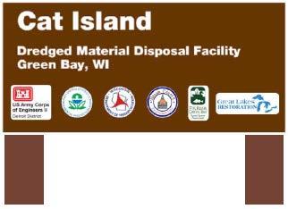
Cat Island Chain Restoration
|
|
|
- Oswald Matthews
- 5 years ago
- Views:
Transcription

1 Cat Island Chain Restoration

2 1820s Fox River Military Road Map to Fort Howard 1845 Chart of Green Bay & Fox River

3 Cat Island Chain Cat Island Brown County Aerial Photography, 1938

4 Historic Western view of lower Green Bay Expansive emergent marshes (e.g. Duck Creek delta, Peats Lake) Numerous small islands Beaches and mud flats Submerged aquatic plant beds Photo Courtesy of Tom Erdman, 1966

5 Bass Islands Willow Island Cat Island Lone Tree Island Grassy Island 1966 during low water levels Islands extend 2.5 miles into Green Bay Photo Courtesy of Tom Erdman, 1966

6 Little Tail Point Long Tail Point Peter s Marsh Cat Island Chain Duck Creek Delta Municipal incinerator and landfill Rock dikes hardened the shoreline Photo Courtesy of Tom Erdman, 1970

7 Long Tail Point Bass Islands Cat Island Duck Creek Delta Marsh Landfill I-43 Construction 90% of Coastal Wetlands Lost from Southern Green Bay Agriculture Photo by WDNR, 1969


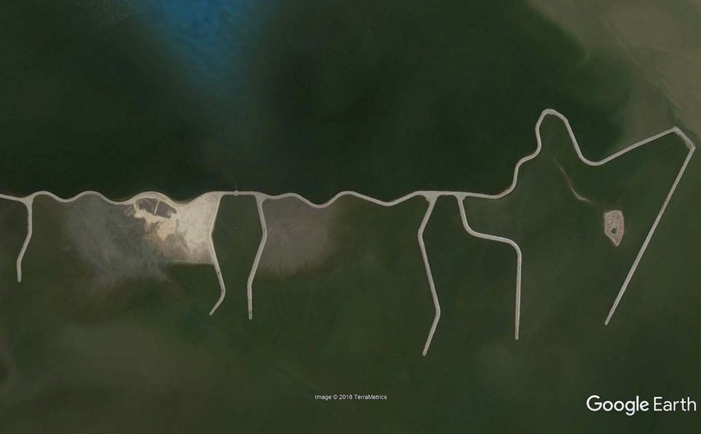
8 Cat Island Chain

 and")


9 Project Beginning The Cat Island Chain project developed out of the 1988 Lower Green Bay Remedial Action Plan (RAP) and was the top priority project for habitat restoration. Members of the Citizens Advisory Committee and DNR staff worked together to develop the Lower Green Bay Remedial Action Plan. (Photo by Dave Crehore)

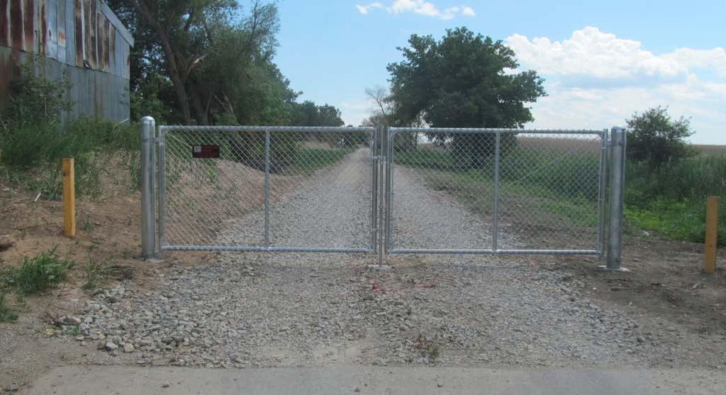
10 Cat Island

11 Green Bay Shipping Channel

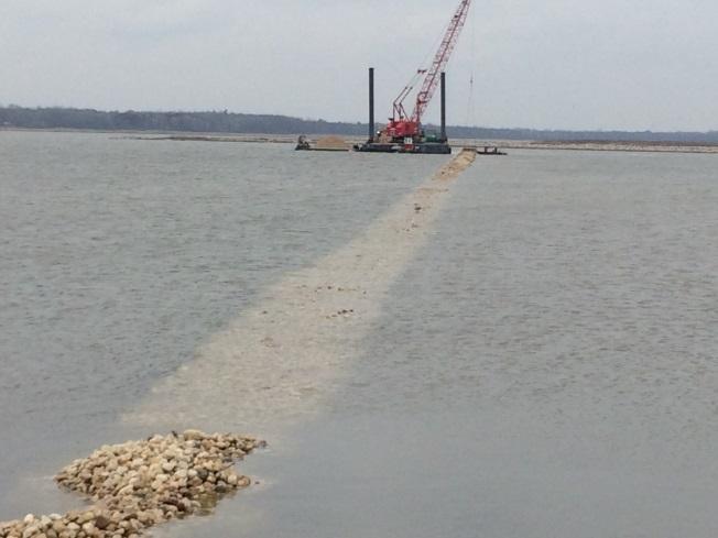
12 Annual Dredging Annual maintenance dredging is necessary to keep the Port of Green Bay active Annual dredging of 100,000 to 250,000 CY of sediment that has settled into the 14 mile long navigational channel

13 Project Goals Restore diversity of island and aquatic habitats Recreate 1960s island footprint Enhance spawning and nursery grounds for various fish species (e.g. yellow perch, musky, pike, walleye, sunfish) Create disposal capacity Beneficially use dredged material from the maintenance of the Port of Green Bay Photo by WDNR 1969


14 Partnership between: Project Partners Brown County, WDNR, WDOT, US Fish & Wildlife Service US Army Corps of Engineers, USEPA, UW-Sea Grant, UW-Green Bay Port Operators and the Fox River Group of paper mills Cat Island Advisory Committee (CIAC) Citizen Member

15 Lake Bed Grant


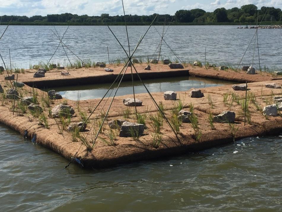
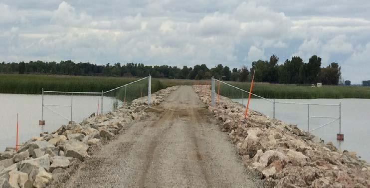
16 Construction Phase I - June 2012 Cat Island Brown County Aerial Photography, 2012


17 Construction Phase II - October 2012 December 17, 2012

18 May 16, 2013 Tons ($) Gravel 41,788 $ 158,379 Core Stone 504,411 $ 1,743,609 Armor Stone 161,666 $ 1,611,829 Total 707,865 $ 3,513,817 Approx. 34,000 truckloads November 12, % Complete
19 Project Costs Original Actual Project Cost $ 34,190,889 $ 19,281,931 Less Brown County GLRI Grant $ 1,500,000 $ 1,450,053 Total Project Costs $ 32,690,889 $ 17,831,878 65% Federal Share $ 21,249,078 $ 11,182,838 35% Non-Federal Share $ 11,441,811 $ 6,649,040 Total Project Costs $ 32,690,889 $ 17,831,878 Non-Federal Funding Sources WDOT Harbor Assistance Grant $ 7,141,835 $ 5,319,232 NRDA Funds $ 800,000 $ 800,000 Terminal Operator Harbor Fees $ 499,000 $ 529,808 Brown County $ 336,459 $ - Brown County In-Kind $ 150,000 $ - Total Non-Federal Funds $ 8,927,294 $ 6,649,040 25% Non-Federal In-Kind Contribution $ 8,172,722 $ 4,457,970 10% Non-Federal Cash Contribution $ 3,269,089 $ 1,783,188
20 Sediment Disposal Island Area (acres) Storage Capacity (yards 3 ) Years Remaining (assume 2 yr cycles and sequential filling) West Island ,000 8 Central Island 92 1,140, East Island 106 1,680, Only outer harbor clean sediments will be placed onto the islands

21 September 9, 2014

22 May 7, 2015

23 July 2, 2015

24 October 24, 2016

25 October 26, 2016

26 April 21, 2017


27 Habitat Impacts Colonial Nesting Water Birds Shorebirds Waterfowl Fish Spawning Fish Nurseries Turtles Amphibians Invertebrates


28 Importance of the area Interior sites gaining recognition for importance Lower Green Bay identified as important shorebird staging area 35 species reported via ebird in Wisconsin portion of Green Bay American Avocets
29 Cat Island Habitat Projects Tern Platforms Plantings and Monitoring Plover Habitat Brown County Aerial Photography, 2017


30 Piping Plover Piping Plover successfully bred on westernmost island in 2016 & 2017 First local breeding in 75+ years

31 Tern Platforms


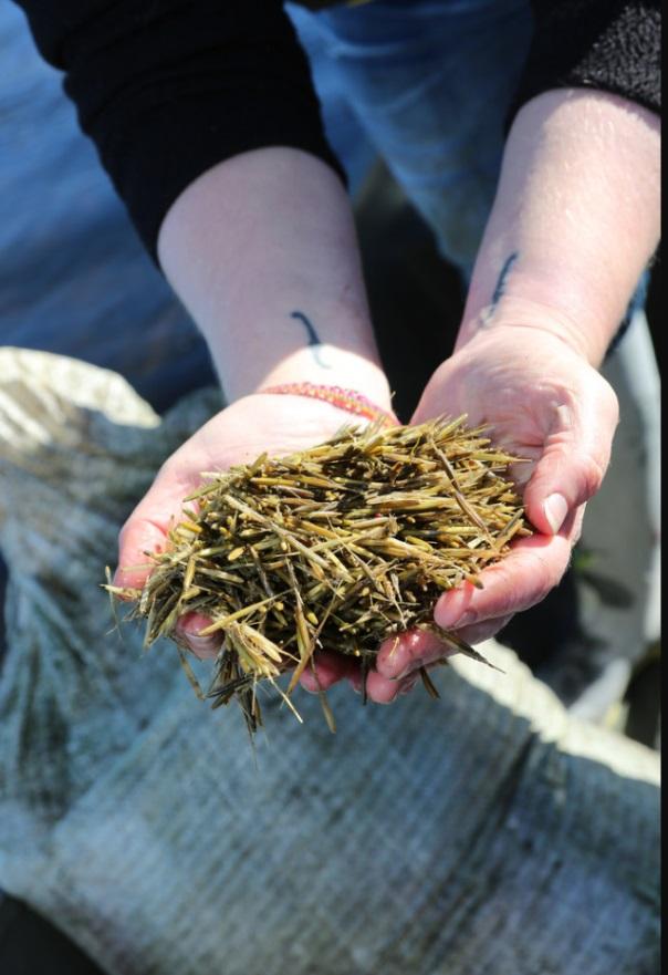
32 Wild Rice Planting Courtesy UWGB, 2015, 2016
 84,293 CY from transition area to Bay Port")
33 FY17 Dredging Activities Rear Barrier placed in center cell 38,500 CY to Cat Island (100,000 to be placed in 2018) 84,293 CY from transition area to Bay Port Cell 5
34 On-Going Issues Management Cat Island Advisory Committee (CIAC) Public Access Public Safety Sensitive Wildlife Habitat Area Filling Sequence and Timing Removal of Causeway

35 Public Access

36 November 8, 2017


37 2017 CENTER CELL BARRIER INSTALLATION Approximately 2300 LF of geotextile lined gabion-style barrier placed across the back of the center island
38 Barrier Construction Barrier
39 Cat Island Chain Cat Island Brown County Aerial Photography, 2017
40 Project Outcomes years worth of disposal capacity Beneficial reuse of dredged material 2.5 mile wave barrier and re-establishment of 272 acres of islands Wave barrier protecting 1,225 acres and providing critical habitat for birds, fish and mammals Improved water clarity increasing weed grown for fish spawning and serving as a nursery and improved migratory bird sanctuary/lay over


41 Questions? Mark Walter Brown County Port & Resource Recovery Department
FACT SHEET I. LOCATION
 STEAMBOAT ISLAND HABITAT REHABILITATION AND ENHANCEMENT PROJECT (HREP) SCOTT COUNTY, IOWA, UPPER MISSISSIPPI RIVER RESTORATION-ENVIRONMENTAL MANAGEMENT PROGRAM ROCK ISLAND DISTRICT FACT SHEET I. LOCATION
La Quinta Channel Extension Port of Corpus Christi Ingleside, Texas. Mark Coyle
 La Quinta Channel Extension Port of Corpus Christi Ingleside, Texas Mark Coyle Corpus Christi Navigation Channel PCCA La Quinta Expansion Project History Corpus Christi Ship Channel Improvement Projects
LaSalle Park Marina Wave Break
 LaSalle Park Marina Wave Break Federal and Municipal Environmental Assessment Background History of the Marina and LaSalle Park The LaSalle Park Marina is located in LaSalle Park at the foot of LaSalle
Emergent Sandbar Habitat Program Middle Missouri River
 Emergent Sandbar Habitat Program Middle Missouri River Jeremiah Szynskie, P.E. Hydrologic Engineering Branch Introduction Main Stem System Dam Closures Fort Peck 1937 Fort Randall 1952 Garrison - 1953
Friends of the Detroit River Habitat Restoration Project Update
 Friends of the Detroit River Habitat Restoration Project Update 11 Beneficial Use Impairments (BUIs) were originally identified to be associated with the Detroit River: 1. Restrictions on fish and wildlife
Building Coastal Resiliency at Plymouth Long Beach
 Building Coastal Resiliency at Plymouth Long Beach Department of Marine and Environmental Affairs March 30, 2017 Introducing Green Infrastructure for Coastal Resiliency Plymouth Long Beach & Warren s Cove
Conservation and Restoration Florida s Coastal Marshes: An Overview of MESS. Jeff Beal, Kent Smith, Erin McDevitt, Maria Merrill
 Conservation and Restoration Florida s Coastal Marshes: An Overview of MESS Jeff Beal, Kent Smith, Erin McDevitt, Maria Merrill FWC s MESS: -Marine/Estuarine Subsection -within Aquatic Habitat Conservation
FACT SHEET MCGREGOR LAKE RESTORATION HABITAT PROJECT POOL 10, UPPER MISSISSIPPI RIVER, WISCONSIN ENVIRONMENTAL MANAGEMENT PROGRAM
 FACT SHEET MCGREGOR LAKE RESTORATION HABITAT PROJECT POOL 10, UPPER MISSISSIPPI RIVER, WISCONSIN ENVIRONMENTAL MANAGEMENT PROGRAM LOCATION McGregor Lake is located within a mid-river island in Pool 10
Water Resources Report RKLD Annual Meeting July 30, 2016
 Water Resources Report RKLD Annual Meeting 2016 July 30, 2016 Topics Hydrology Report Indianford Dam trash rack cleanout performance Experimental Project update Review of PAS project Twin floods- 1 to
Fish Community. Fish Habitat, Streams and Rivers
 Clear, Ston(e)y and White Lake Plan Fish Community The lakes support a cool/warm water fishery including muskellunge, walleye, largemouth and smallmouth bass, yellow perch, pumpkinseed, rockbass, blue
PLAQUEMINES PARISH BARRIER ISLAND RESTORATION & SUSTAINABILITY. MVD/Gulf Coast Regional Dredging Meeting November 5, 2013
 PLAQUEMINES PARISH BARRIER ISLAND RESTORATION & SUSTAINABILITY MVD/Gulf Coast Regional Dredging Meeting November 5, 2013 OVERVIEW 1. Barrier Island Restoration Projects in Plaquemines Parish 2. Plaquemines
Estimated on-the-ground start and end dates: 1 June October 2018
 A. Applicant Information Name of Organization: U.S. Army Corps of Engineers, Carlyle Lake 801 Lake Road, Carlyle, IL 62231 Contact Information: Robert Wilkins, Operations Manager, (618) 594-2484, Robert.Wilkins@usace.army.mil
Warm-up # 7 A day 5/17 - B day 5/18 UPDATE YOUR TABLE OF CONTENTS
 Warm-up # 7 A day 5/17 - B day 5/18 UPDATE YOUR TABLE OF CONTENTS Question: List all examples of surface water on Earth. Answer: Rivers and streams, lakes and reservoirs, (ponds) wetlands, estuaries and
ALTERNATIVES FOR COASTAL STORM DAMAGE MITIGATION
 ALTERNATIVES FOR COASTAL STORM DAMAGE MITIGATION Dave Basco Old Dominion University, Norfolk, Virginia, USA National Park Service Photo STRUCTURAL (changes to natural, physical system) hardening (seawalls,
Restoration of Eelgrass to Upper Casco Bay: Feasibility Tests in Hilary A. Neckles US Geological Survey Augusta, ME
 Restoration of Eelgrass to Upper Casco Bay: Feasibility Tests in 2015 Hilary A. Neckles US Geological Survey Augusta, ME hneckles@usgs.gov Robert J. Orth Eelgrass: Zostera marina * marine flowering plant
Essential Fish Habitat: An overview of the consultation requirement for the American Association of Port Authorities
 Essential Fish Habitat: An overview of the consultation requirement for the American Association of Port Authorities National Marine Fisheries Service, Southeast Regional Office Habitat Conservation Division,
Illinois Lake Management Association Conference March 23, 2018 By Trent Thomas Illinois Department of Natural Resources Division of Fisheries
 Illinois Lake Management Association Conference March 23, 2018 By Trent Thomas Illinois Department of Natural Resources Division of Fisheries Sources of Habitat Impairment Sedimentation Channelization
Dauphin Island East End Beach and Barrier Island Restoration Project. Beau Buhring South Coast Engineers
 Dauphin Island East End Beach and Barrier Island Restoration Project Beau Buhring South Coast Engineers Funding Funded with qualified outer continental shelf oil and gas revenues by the Coastal Impact
Follets Island Nearshore Beach Nourishment Project
 Coast & Harbor Engineering A division of Hatch Mott MacDonald Follets Island Nearshore Beach Nourishment Project Arpit Agarwal, P.E. April 1, 2016 Project Site!"#$% &'(% &)*+% )#,'-+% Shoreline Erosion
Puget Sound Nearshore Ecosystem Restoration Project Restore America s Estuaries Conference 2012 Tampa, FL
 Restore America s Estuaries Conference 2012 Tampa, FL presented by: Theresa Mitchell, WA Dept. of Fish & Wildlife Nearshore General Investigation Change Analysis: Comparison of historical and current
Current Status and Management Recommendations for the Fishery in the Cloverleaf Chain of Lakes
 Current Status and Management Recommendations for the Fishery in the Cloverleaf Chain of Lakes Jason Breeggemann Senior Fisheries Biologist Wisconsin Department of Natural Resources Outline DNR fisheries
Puget Sound Shorelines. Waves and coastal processes. Puget Sound shorelines: Effects of beach armoring
 Puget Sound Shorelines Puget Sound shorelines: Effects of beach armoring Waves and coastal processes Factors affecting wave energy hitting the coast Processes transporting sediment along coastlines What
Case Study: Merritt Island National Wildlife Refuge
 Case Study: Merritt Island National Wildlife Refuge Read the case study below. As you read, complete the Case Study Notetaking worksheet. Geography Cape Canaveral is on the east coast of Florida, roughly
MILE POINT TRAINING WALL JACKSONVILLE, FL. Geotextile Tube Installation
 MILE POINT TRAINING WALL JACKSONVILLE, FL Geotextile Tube Installation PROJECT DESIGN Remove portion of existing training wall Construct new eastern and western training walls Deepen new flow improvement
MOREHEAD CITY HARBOR, NC. Dredged Material Management Plan (DMMP)
") MOREHEAD CITY HARBOR, NC Dredged Material Management Plan (DMMP) Public Meeting/Info Session 15 January 2014 US Army Corps of Engineers Morehead City Harbor DMMP Presentation Topics Morehead City Harbor
MOREHEAD CITY HARBOR, NC Dredged Material Management Plan (DMMP) Public Meeting/Info Session 15 January 2014 US Army Corps of Engineers Morehead City Harbor DMMP Presentation Topics Morehead City Harbor
RESTORING 400 ACRES OF TIDAL MARSH IN THE SNOHOMISH RIVER DELTA
 RESTORING 400 ACRES OF TIDAL MARSH IN THE SNOHOMISH RIVER DELTA Marya Moses, Danny Moses, Neil Moses, and Robert Moses fish on Tulalip Bay, near the mouth of the Snohomish River Estuary. QWULOOLT IS A
Examples of estuaries include bays, sounds, salt marshes, mangrove forests, mud flats, swamps, inlets, and sloughs.
 An estuary is a partially enclosed body of water where incoming seawater is mixed with fresh water coming from the land. Examples of estuaries include bays, sounds, salt marshes, mangrove forests, mud
ALTERNATIVES FOR COASTAL STORM DAMAGE MITIGATION AND FUNCTIONAL DESIGN OF COASTAL STRUCTURES
 The University of the West Indies Organization of American States PROFESSIONAL DEVELOPMENT PROGRAMME: COASTAL INFRASTRUCTURE DESIGN, CONSTRUCTION AND MAINTENANCE A COURSE IN COASTAL DEFENSE SYSTEMS I CHAPTER
ROUTE 2. Bateau Channel. Topographic Map 31 C/8 Navigation Charts 1438/39 Reference Maps
 Topographic Map 31 C/8 Navigation Charts 1438/39 Reference Maps ROUTE 2 Bateau Channel The shoreline marshes of the Bateaux Channel team with life. Wetlands provide breeding habitat for amphibians, fish
The Blue Heron Slough Conservation Bank
 1 The Blue Heron Slough Conservation Bank CONSERVATION BANKING July 19-23, 2010 CASE STUDY SERIES The Blue Heron Slough Conservation Bank (Washington) I. OVERVIEW & BACKGROUND: Location: Snohomish River
Introduction: JadEco, LLC PO BOX 445 Shannon, IL 61078
 Introduction: was contacted to collected data on the fishery for Lake Holiday. AC Electroshocking was conducted at 2 locations on September 28, 2015. Fish population data was collected for a total of 100
Atlantic Coast of Long Island, Jones Inlet to East Rockaway Inlet, Long Beach Island, NY Construction Update
 Atlantic Coast of Long Island, Jones Inlet to East Rockaway Inlet, Long Beach Island, NY Construction Update June 2016 US Army Corps of Engineers Project Purpose Three specific damage mechanisms of coastal
Grays Harbor Federal Project
 Grays Harbor Federal Project Elizabeth Chien Coastal Navigation Program Manager Seattle District 27 October 2016 US Army Corps of Engineers Grays Harbor Navigation Channel Inner Harbor Dredging Summer
COMMUNITY WATERSHED PROJECT
 SABINE RED RIVER COMMUNITY WATERSHED PROJECT A Watershed Approach to Aquatic Resources Do you have a stake in the water, the wildlife, the use of the land? Help us do for fish what was done for ducks*.
Geographic Response Plan Map: SC-17
 79 37'30"W Geographic Response Plan Map: SC-17 79 30'0"W 33 7'30"N Charleston County 33 7'30"N 33 0'0"N 79 37'30"W [ Awendaw [j [e!d!s(!d Graham Creek FRANCIS MARION NATIONAL FOREST 450 Awendaw Creek [j
ADOPT-A-STREAM WATERSHED APPROACH COMMUNITY-BASED STEWARDSHIP. Nova Scotia Salmon Association March 2005
 ADOPT-A-STREAM A WATERSHED APPROACH TO COMMUNITY-BASED STEWARDSHIP Nova Scotia Salmon Association March 2005 This manual is a revised and updated version of the 1994 Adopt-a-Stream manual that was prepared
FINAL ENVIRONMENTAL IMPACT STATEMENT ON BROWARD COUNTY SHORE PROTECTION PROJECT SEGMENTS II AND III BROWARD COUNTY, FLORIDA
 FINAL ENVIRONMENTAL IMPACT STATEMENT ON BROWARD COUNTY SHORE PROTECTION PROJECT SEGMENTS II AND III BROWARD COUNTY, FLORIDA 1. PROJECT PURPOSE AND NEED 1.1. PROJECT AUTHORITY. 1.1.1. INITIAL AUTHORIZATION.
Geotube Breakwater Project The Geotube at Grass Lake in northern Illinois.
 Geotube Breakwater Project The Geotube at Grass Lake in northern Illinois. Final approval for our prototype Geotube project was received on October 21, 2005. The Geotube is a coated fabric tube that is
STRATUS CONSULTING. Green Bay NRDA Injury Assessment Case Study
 Green Bay NRDA Injury Assessment Case Study The Lower Fox River/Green Bay Environment Home and critical habitat to array of ecological resources, including fish, birds, and mammals Extensive Human Use
Adapting to Climate Change In Coastal Environments
 Adapting to Climate Change In Coastal Environments Peter Nimmrichter, P.Eng. AMEC Earth and Environmental, Mississauga, Ontario 19/11/2007 1 The Great Lakes Watershed The Great Lakes cover an area of 244,160
Kissimmee River Channelization
 Environmental Restoration ti Update Phil Flood, South Florida Water Management District Presentation Overview Kissimmee River Restoration Everglades Stormwater Treatment Areas Comprehensive Everglades
Navarre Beach & Dune Restoration Project Status Report to be regularly updated June 17, 2016 Report
 Navarre Beach & Dune Restoration Project Status Report to be regularly updated June 17, 2016 Report Work Completed (June 11 to June 17) Weeks Marine Inc. (Contractor): o continued filling Segment 4 including
Restoring the Iconicc Lower Cache River
 Restoring the Iconicc Lower Cache River A new chapter holds promise of revitalizing cherished waters and woods The story of conservation in the lower Cache River and surrounding Big Woods of eastern Arkansas
Louisiana CPRA SJB Group, Baton Rouge Coastal Engineering Consultants U.S. Army Corps of Engineers Federal and State PDT Members
 Louisiana CPRA SJB Group, Baton Rouge Coastal Engineering Consultants U.S. Army Corps of Engineers Federal and State PDT Members Project Setting and Background Island Restoration Plans Pre-Screening Analysis
Three point plan to addressing land use and habitat loss impacts on Chesapeake Bay tidal fish and shellfish
 Three point plan to addressing land use and habitat loss impacts on Chesapeake Bay tidal fish and shellfish 1. Establish Principles for Protection of Chesapeake Bay Fish and Shellfish The Fisheries GIT
Project Webpage:
 Project Webpage: http://nature.ly/marinesatlanticbightera Coastal Data and Full Metadata: http://easterndivision.s3.amazonaws.com/marine/sab MA/SABMACoastalEcosystems.zip Coastal Chapter: http://easterndivision.s3.amazonaws.com/marine/sab
Longshore Bar Creation: a viable option for seagrass restoration?
 Longshore Bar Creation: a viable option for seagrass restoration? Lindsay M. Cross, Tampa Bay Estuary Program Holly Greening, Tampa Bay Estuary Program Michael Seifert, Tampa Port Authority Susan Burtnett,
National Wildlife Refuge System
 Eufaula National Wildlife Refuge part of the US Department of the Interior US Fish and Wildlife Service National Wildlife Refuge System What is the National Wildlife Refuge System? Our Mission: The mission
COA-F17-F-1343 YEAR END REPORT
 DAVE MARSHALL SALMON RESERVE RESTORATION, MAINTENANCE, AND UPGRADES YEAR END REPORT Prepared for: Fish and Wildlife Compensation Program Prepared by: Edith Tobe, RPBio, Executive Director Box 1791, Squamish,
SALINITY. It's the amount of dissolved salts the water contains.
 AQUATIC ECOSYSTEMS SALINITY The types of organisms in an aquatic ecosystem depend upon the water s Salinity. It's the amount of dissolved salts the water contains. Salinity determines the two main aquatic
The 2017 Panama City Beaches Beach Interim Renourishment Project. Answers to Common Questions
 The 2017 Panama City Beaches Beach Interim Renourishment Project The fourth renourishment of the Panama City Beaches will be under construction during March and April 2017, with a planned completion by
U.S. Army Corps of Engineers (USACE) P.O. Box 428 Smithville, MO
 P.O. Box 428 Smithville, MO") Applicant Information United States Army Corps of Engineers Kansas City District Principal Contact: Derek Dorsey, Natural Resource Manager U.S. Army Corps of Engineers P.O. Box 428 Smithville, MO 64089
Applicant Information United States Army Corps of Engineers Kansas City District Principal Contact: Derek Dorsey, Natural Resource Manager U.S. Army Corps of Engineers P.O. Box 428 Smithville, MO 64089
TOWN OF DENNIS 10 YR COMPREHENSIVE DREDGE PERMIT SEPTEMBER 10, 2013
 TOWN OF DENNIS 10 YR COMPREHENSIVE DREDGE PERMIT SEPTEMBER 10, 2013 WHAT IS IT? ALL NECESSARY PERMITS FOR DREDGING FOR PORTIONS OF BASS RIVER, SWAN POND RIVER, SESUIT HARBOR AND CHASE GARDEN CREEK ONE
Map of Special Places in Florida
 Map of Special Places in Florida 17 5 FLORIDA INTRODUCTION Gulf Islands National Seashore Florida District BASIC SEASHORE FACTS With 12 units altogether in Florida and Mississippi, Gulf Islands National
Tips for Using & Printing Spreadsheets
 Key to Spreadsheets Spreadsheet # Type Description/Purpose a Development & Construction in Waterways b Debits Development & Construction in Other Aquatic Areas c Indirect Impacts to Waterways from Development
Alberta Conservation Association 2016/17 Project Summary Report
 Alberta Conservation Association 2016/17 Project Summary Report Project Name: Piping Plover Recovery Program Wildlife Program Manager: Doug Manzer Project Leader: Lance Engley Primary ACA staff on project:
Mid-Columbia Fisheries Enhancement Group Annual Report Fiscal Year 06: July 1, 2005 June 30, 2006
 Mid-Columbia Fisheries Enhancement Group Annual Report Fiscal Year 06: July 1, 2005 June 30, 2006 Mission Statement The mission of the Mid-Columbia Fisheries Enhancement Group is to restore self-sustaining
VIDEO AUDIO Slide 1. Slide 2 Old timey 18 th century map of east coast
 VIDEO AUDIO Slide 1 1A Welcome to the Cooper River Rediversion Project at St. Stephen, Montage of exteriors of facility, South Carolina! Since 1985, this boating, fish runs, fishing, facility has served
Creation of Fish and Wildlife Habitat on the Closed Salmon Harbour Mine in Minto, NB
 Creation of Fish and Wildlife Habitat on the Closed Salmon Harbour Mine in Minto, NB M. Coleman 1, R. Rutherford 2, RA Currie 3 1 NB Power 2 Thaumas Environmental Consultants Ltd 3 RA Currie Ltd. Location
Klickitat County Shoreline Master Program Update. Open House March 15, 2017
 Klickitat County Shoreline Master Program Update Open House March 15, 2017 Agenda 6:00 6:10 Welcome 6:10 6:40 Presentation SMP Update Process Shoreline Analysis review 6:40 8:00 Open House Topics SMP Process
A FISHING BAN ON GRENADIER POND
 A FISHING BAN ON GRENADIER POND The activity or sport of fishing should be banned commencing spring of 2013 pending a study to determine whether, and in what particular circumstances, fishing can be considered
2018 Beach Preservation Project Information
 QUICK FACTS Beach Renourishment to begin late April 2018 o U.S. Army Corps of Engineers project o Project Area: 8 th St. E. to end of E. Ashley Ave. o Project Length: 2 miles o Cost: $10,900,000 o Funding:
Acknowledgements Frank C. Bellrose & Daniel Holm
 Nesting Ducks of Tennessee Wood Ducks, Mallards, Hooded Mergansers Billy Minser UT FWF Acknowledgements Frank C. Bellrose & Daniel Holm Dick McCabe Featuring Frank Bellrose and Scott Neilson 1 There are
Eelgrass and Macroalgae Presence/Absence Preliminary Surveys BHP Proposed Grays Harbor Potash Export Facility A Task 400
 Memorandum 40600-HS-MEM-55036 Revision 0 Date: 26 July 2018 Subject: Eelgrass and Macroalgae Presence/Absence Preliminary Surveys BHP Proposed Grays Harbor Potash Export Facility A17.0202.00 Task 400 INTRODUCTION
Big Spring Creek Habitat Enhancement and Fishery Management Plans
 Big Spring Creek Habitat Enhancement and Fishery Management Plans November 5, 2012 Big Spring Events and Activities Center Newville, PA Charlie McGarrell Regional Habitat Biologist Pennsylvania Fish and
Initial recovery of flora and fauna at restored mosquito impoundments in Indian River Lagoon, FL
 Initial recovery of flora and fauna at restored mosquito impoundments in Indian River Lagoon, FL Melinda Donnelly PhD Candidate, University of Central Florida Ron Brockmeyer, Linda Walters, William Greening,
What was the historic coaster fishery like?
 1 of 6 1/30/2012 12:25 PM Home About Topics Contact Us Fishing Calendar Fish ID Tips FAQs Hack Noyes Research Vessel Is it a unique strain long lost from Wisconsin's shoreline? Fisheries Reports Tributaries
Fish Texas AQUATIC ECOSYSTEMS
 27 Additionally, healthy aquatic communities in Texas rivers, reservoirs and estuaries provide unparalleled recreational opportunities to millions of Texans. Our fresh and saltwater environments vary from
OKANAGAN RIVER RESTORATION INITIATIVE - FAQ
 OKANAGAN RIVER RESTORATION INITIATIVE - FAQ Initiative background: The health of the q awsitk w (Okanagan River) has been severely impacted by the channelization works that occurred in the mid-1950 s.
Rhode Island Department of Environmental Management Division of Fish and Wildlife American Shad Habitat Plan for the Pawcatuck River
 Rhode Island Department of Environmental Management Division of Fish and Wildlife American Shad Habitat Plan for the Pawcatuck River Prepared by: Phil Edwards, Rhode Island Department of Environmental
Starry Stonewort in Silver Lake Washington County, WI BRAD STECKART AIS COORDINATOR FOR WASHINGTON AND WAUKESHA COUNTIES
 Starry Stonewort in Silver Lake Washington County, WI BRAD STECKART AIS COORDINATOR FOR WASHINGTON AND WAUKESHA COUNTIES Brad Steckart -AIS coordinator for Washington and Waukesha Counties -Graduated from
11426 Moorage Way P.O. Box 368 LaConner, WA Phone: Fax:
 Skagit River System Cooperative 11426 Moorage Way P.O. Box 368 LaConner, WA 98257-368 Phone: 36-466-7228 Fax: 36-466-447 www.skagitcoop.org BULL TROUT USE OF SWINOMISH RESERVATION WATERS Eric Beamer, Rich
Grays Harbor O&M and Deepening Dredging
 Grays Harbor O&M and Deepening Dredging Elizabeth Chien Project Manager Seattle District 28 January 2016 US Army Corps of Engineers Grays Harbor Navigation Channel Inner Harbor O&M Dredging Summer 2015:
SHOOTING ISLAND RESTORATION: LIVING SHORELINE AND HABITAT CONSTRUCTION
 : : : : LIVING SHORELINE AND HABITAT CONSTRUCTION CITY OF OCEAN CITY, NEW JERSEY CONTRACT NO. 8 ID 4468 Sheet List Table Sheet Number Sheet Description Sheet Title Newark T- TITLE SHEET G- SITE OVERVIEW
U.S. Fish and Wildlife Service Native American Crosscut Funding
 U.S. Fish and Wildlife Service Native American Crosscut Funding Tribal / Interior Budget Council National Budget Meeting L Enfant Plaza Hotel Washington, DC November 8, 2013 U.S. Fish and Wildlife Service
WHAT ARE ECOSYSTEMS? Dr. V. N. Nayak Professor of Marine Biology (Retd)
") WHAT ARE ECOSYSTEMS? Dr. V. N. Nayak Professor of Marine Biology (Retd) An ECOSYSTEM is an interacting system of plant, animals, and humans and the surrounding environment. An ecosystem contains living
WHAT ARE ECOSYSTEMS? Dr. V. N. Nayak Professor of Marine Biology (Retd) An ECOSYSTEM is an interacting system of plant, animals, and humans and the surrounding environment. An ecosystem contains living
COASTAL CONSERVANCY. Staff Recommendation March 25, 2004 HUNTINGTON BEACH WETLANDS RESTORATION PLAN. File No Project Manager: Trish Chapman
 COASTAL CONSERVANCY Staff Recommendation March 25, 2004 HUNTINGTON BEACH WETLANDS RESTORATION PLAN File No. 04-008 Project Manager: Trish Chapman RECOMMENDED ACTION: Authorization to disburse up to $300,000
FWCP External Projects Delivered by Stakeholders and First Nations
 FWCP External Projects Delivered by Stakeholders and First Nations 2013-2014 For more information contact FWCP-Columbia program manager, Trevor Oussoren Trevor.oussoren@bchydro.com 250-365-4551 2013-2014
Ecology of Place: What salmon need Eric Beamer Skagit River System Cooperative. November 2010
 Ecology of Place: What salmon need Eric Beamer Skagit River System Cooperative November 2010 Acknowledgements NOAA Fisheries NW Fisheries Science Center Tim Beechie George Pess Correigh Greene Talk overview
MISSISSIPPI MAKEOVER A Plan for Restoration, Just Around the Bend
 MISSISSIPPI MAKEOVER A Plan for Restoration, Just Around the Bend Interim Report Card 2013 Project coordinated by the Dakota County Soil and Water Conservation District and sponsored by the Minnesota Pollution
APPENDIX M DREDGED MATERIAL MANAGEMENT PLAN (DMMP) FINAL INTEGRATED FEASIBILITY REPORT AND ENVIRONMENTAL ASSESSMENT
 FINAL INTEGRATED FEASIBILITY REPORT AND ENVIRONMENTAL ASSESSMENT") APPENDIX M DREDGED MATERIAL MANAGEMENT PLAN (DMMP) Brazos Island Harbor, Texas Channel Improvement Study FINAL INTEGRATED FEASIBILITY REPORT AND ENVIRONMENTAL ASSESSMENT This page is intentionally left
APPENDIX M DREDGED MATERIAL MANAGEMENT PLAN (DMMP) Brazos Island Harbor, Texas Channel Improvement Study FINAL INTEGRATED FEASIBILITY REPORT AND ENVIRONMENTAL ASSESSMENT This page is intentionally left
Sediment Management Plan Rehoboth Bay
 Sediment Management Plan Rehoboth Bay STAC Meeting November 16, 2007 Goals of the Study Improve planning for future dredging needs Reduce the dependency on dredging Study Tasks Environmental data Historical
RED RIVER NATIONAL WILDLIFE REFUGE
 RED RIVER NATIONAL WILDLIFE REFUGE http://www.fws.gov/refuge/red_river/ https://www.facebook.com/redrivernwr Photograph of wood ducks taken on Refuge by volunteer Ronnie Maum Wildlife Quiz 4 Bird Species
Final Waterways Assets and Resources Survey Master Plan for Dredging and Beach Nourishment
 Final Waterways Assets and Resources Survey Master Plan for Dredging and Beach Nourishment For, Massachusetts Prepared For: Dennis Town Hall P.O. Box 2060 485 Main Street Dennis, MA 02660 Prepared By:
Preserving Biological Diversity for Future Generations
 The U.S. Fish and Wildlife Service Preserving Biological Diversity for Future Generations Flavia Rutkosky US Fish and Wildlife Service Delaware Bay Estuary Bay Project Office Smyrna, Delaware BIOLOGICAL
ST. LOUIS SECTION PROJECT OF THE YEAR AWARD
 ST. LOUIS SECTION PROJECT OF THE YEAR AWARD Originality and Innovation The St. Louis Harbor Project is located in the Upper Mississippi River between the entrance to the Chain of Rocks Canal at River
CHAPTER 4 DESIRED OUTCOMES: VISION, GOALS, AND OBJECTIVES
 CHAPTER 4 DESIRED OUTCOMES: VISION, GOALS, AND OBJECTIVES Vision One of the first steps in developing this Plan was articulating a vision - a clear statement of what the Plan strives to achieve and what
Fisheries and Lake Management Planning. CAP Mtg Nov21,2012 Brett Tregunno Aquatic Biologist, Kawartha Conservation
 Fisheries and Lake Management Planning CAP Mtg Nov21,2012 Brett Tregunno Aquatic Biologist, Kawartha Conservation Outline Aquatic Habitat Types Fish Communities Significance of Resource Current Management
Summary of and Initial Response to public comments on MN Department of Natural Resources proposal to manage new waters for Muskellunge
 Summary of and Initial Response to public comments on MN Department of Natural Resources proposal to manage new waters for Muskellunge Summary of and Initial Response to public comments: This document
2015 Annual Report. February 15, 2016
 2015 Annual Report February 15, 2016 2015 Round Lake Management Commission (RLMC) Annual Report Contents The Round Lake Mgt Commission 2015 Year in Review Huebner Fishery Mgt Foundation Shoreline Restoration
Oregon Estuaries defined: (Goal 16)
") Bob Bailey, Manager, Oregon Coastal Management Program Oregon Estuaries defined: (Goal 16) includes estuarine water, tidelands, tidal marshes, and submerged lands. Estuaries extend upstream to the head
Bob Bailey, Manager, Oregon Coastal Management Program Oregon Estuaries defined: (Goal 16) includes estuarine water, tidelands, tidal marshes, and submerged lands. Estuaries extend upstream to the head
Current projects for Fisheries Research Unit of Minnesota Department of Natural Resources
 Current projects for Fisheries Research Unit of Minnesota Department of Natural Resources MAJOR RESOURCE ISSUES IN THE DIVISION OF FISHERIES Status of Fish Populations To effectively manage fish populations,
Mississippi River Project
 Mississippi River Project Marchiing iinto Spriing! Throughout the Mississippi River Project there is snow upon the ground but the smell of spring is in the air. Many of the migratory birds are working
KEYNOTE PRESENTATION FSBPA olsen
 AMELIA ISAND, FLORIDA BEACH MANAGEMENT PARTNERING AND PERSERVERENCE Erik Olsen, PE associates, inc. KEYNOTE PRESENTATION FSBPA 2009 IN ORDER TO ADDRESS SHORE PROTECTION TODAY LOCAL INTERESTS PARTNER WITH:
BAYKEEPER. Utilizing Volunteers in Baykeeper s Oyster Restoration Program
 NY/NJ BAYKEEPER Utilizing Volunteers in Baykeeper s Oyster Restoration Program Meredith Comi, Oyster Restoration Program Director Hooked on our Waters October 19, 2013 Baykeeper s Mission PROTECT, PRESERVE,
Eastern Shore Islands Area of Interest Community Newsletter
 Eastern Shore Islands Area of Interest Community Newsletter Fall 2018 1ỊNTRODUCTION In addition to information on our Fisheries and Oceans Canada (DFO) website, we have now created a seasonal, community
MCCAW REACH RESTORATION
 Final Report MCCAW REACH FISH RESTORATION PHASE B Jack McCaw Inland Empire Action Coalition http://www.wwccd.net/ Phone: 509-956-3777 Hours: 8:00-4:30 Walla Walla County Conservation District Snake River
Species Conclusions Table
 Conclusions Table Project Name: Chesapeake Landing HOA- Breakwaters (NAO-14-0283) Date: February 25, 2014 /Resource Name Loggerhead sea turtle (Caretta caretta) Conclusion ESA Section 7 / Eagle Act Determination
Otto E. Langer - Fisheries Biologist and Aquatic Ecologist. October 15, 2014.
 Social and Environmental Values in the Fraser River and Estuary in the Sandheads to Annacis Island Reach In Relationship to the Risks Caused by the Approved VAFFC* Proposal to Ship Jet Fuel into the Fraser
XXX. Chisolm Island Creeks. Map Continued on SC-48. Judge Island. SC49-03 Jenkins Creek/Morgan River Intersection XXX. Saint Helena Island
 w River 32 30'0"N ufort County 80 37'30"W 802 Coosaw River 250 450 SC41-05 Geographic Response SC41-03 Plan Map: Coosaw SC-49 River Chisolm Island Chisolm Island s u Map Continued on SC-41 3 (west side)