SOONER LAKE MANAGEMENT PLAN
|
|
|
- Clyde Tyler
- 5 years ago
- Views:
Transcription
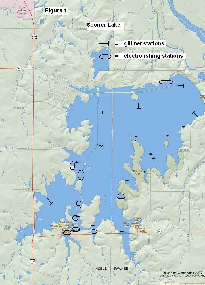
1 SOONER LAKE MANAGEMENT PLAN Background Lake Sooner impounds Greasy Creek, 15 miles south of Ponca City in Noble and Pawnee Counties, Oklahoma (Figure 1). The Grease Creek basin that Sooner Lake impounds is a small, prairie grass watershed. The silt load is light and is trapped on the West side of Highway 177. Overall water quality is very high due to the small size and quality of the watershed which results in very stable water levels even during heavy spring rain events. Sooner Lake covers 5,400 surface acres and was constructed in 1976 by the Oklahoma Gas and Electric Company to serve as a cooling reservoir. The thermal impact of the plant is limited to the west side of the lake which only cover about 25 percent of the total area of the lake, so the main body of Sooner lake is thermally unaffected. Sooner Lake is located close to the Arkansas River and was initially filled and water levels are now maintained by pumping water from the Arkansas. Sooner Lake has a mean depth of 28 feet and a maximum depth of 89 feet, a shoreline development ratio of 5.2 (the ratio between length of shoreline and surface area), a very low water exchange rate of 0.05 (inflow/storage capacity) and a secchi disc visibility of around 70 inches in the main pool in August; turbidity is primarily from plankton. Fish habitat consists primarily of aquatic vegetation, primarily pondweed, water milfoil and cattails. Due to stable water levels and clear water, aquatic vegetation covers most shorelines
2 and extends out to a depth of six feet. Standing timber is restricted to several coves south of Highway 15 and is not accessible by boat from the main body of the lake. Rip-rap habitat originally covered 9.7 miles but the more exposed stretches were concreted in to prevent further wave erosion. The remaining rip-rap areas are located behind the north and central dykes and covers 4.1 miles of shoreline. Substrates are largely clay with some limited areas of sandstone rock. The surrounding topography is open tall grass prairie which leaves the lake open to the prevailing winds. Water quality Chemical properties measured by the Oklahoma Water Resources Board from November 2006 to August 2007 stated that the trophic state index (TSI) using chlorophyll-a averaged 46, classified the lake as mesotrophic, indicative of moderate levels of primary productivity and nutrient conditions. Thermal stratification occurs throughout the lake during late summer with 52 percent of the water column experiencing anoxic conditions. Depth of stratification ranges from 33 to 36 feet with corresponding temperatures of 80.6 to 78.4 degrees. Water hardness typically is 240ppm and ph ranges from 7.2 to 8.5. Conductivity can range from 1300 to 1900 umho/cm indicated high concentrations of electrical current conduction compounds (salt) were present in the lake. History of Fishery Largemouth bass
3 The largemouth bass fishery at Sooner Lake can be described as very good to excellent. Total bass abundance is very high (C/f>80) and catch rates for fish >14 inches ranges from bass per hour in recent sample years (Table 2) (Figure 2). Sooner lake is also known for Abig or fish >8 pounds. Sooner was stocked with Florida bass in 1977 and 1983 through Stockings were resumed in 2001 (Table 1). A 14 inch minimum length limit was imposed on all black bass in 1979 to minimize the potential for over harvest. In the fall of 2001, tissue samples from 36 largemouth bass, collected throughout the reservoir, were tested for the presence of Largemouth Bass Virus. Results concluded that the virus was present in the largemouth bass population. Seven of the 36 fish sample tested positive resulting in an occurrence of 19.4%. This percent occurrence is fairly low compared to other Oklahoma lakes with viral infections. No fish kills have been reported in the history of the lake. White Crappie Crappie abundance peaked in 1978 (C/f=12.5) and has settled to very low numbers (C/f=1.1) in recent sample years (Table 4). Body condition values are strong and growth rates are fast, however, due to low abundance few anglers target crappie at Sooner Lake (Table 5). White bass White bass abundance is general high with recent gill net catch rates ranging from 16.6 to 6.7 per day (Table 6) (Figure 4). Body
4 condition values decrease with size and few fish exceed 14 inches in length. Due to their smaller size and poor body condition, this fishery is rated as fair. Striped bass Striped bass have been stocked on an irregular basis since 1990 with the goal of creating a trophy fishery (Table 1). Fingerling stocking rates have ranged from one to five fish per acre and have been successful. Stripers in the 10 to 20 pound range have been caught on a regular basis by anglers. Gill net catch rates are low (0.24 to 1.4 per day) and generally fish under six pounds are caught (Table 7). This trophy fishery is in part due to the high water quality of Sooner Lake namely the favorable summer water temperatures at the mesocline (78-80 degrees Fahrenheit). Adult striped bass stop feeding at temperatures above 81 degrees and mortality begins after six weeks. No known summer die-off has occurred on Sooner Lake. Hybrid white bass x striped bass Sooner Lake was the first lake in Oklahoma to be stocked with striped bass hybrids in Fry stockings were successful from but subsequent fry stockings (1986 and 1987) recruited few fish (Table 1). The new, plankton rich lake had given way to high water clarity and reduced plankton abundance. Fingerling stockings were initiated in 1989 and year class strength improved. Recent gill net catch rates have been fairly stable ranging from 6.2 to 12.5 per day (Table 8) (Figure 5). Growth rates are generally below
5 the regional average (Table 9). An aggregate creel limit of five white bass, striped bass or hybrids was initiated in 1982 for the warm water discharge area only. No creel or length limits were placed on striped bass hybrids in the main lake until This regulation limits striped bass, striped bass hybrids or white bass to 20 combined per day, of which only five may be 20 inches or longer. Angler sentiment felt that the hybrid fishery had declined in size and numbers in recent years and were in favor of a more restrictive creel limit in the main body of the lake. Saugeye Saugeye were stocked every other year from 1993 to 1999 but discontinued due to slow growth rates and forage competition with other predators. Recruitment was strong for each year class but the 18" minimum length limit (initiated in 1994) was not reached until the fourth or fifth growing season (Table 10) (Table 11) (Figure 6). Starting in 2001 low numbers of naturally recruited saugeye have been caught. Blue catfish Although blue catfish have never been stocked they have been collected in low numbers since The source of the fish appears to be from the Arkansas River when the lake was being filled. Gill net catch rates in recent sample years range from 0.24 to 1.68 per day and blues up to 20 pounds are not uncommon (Table 12). The current lake record weighs 66 pounds. Blue catfish anglers usually fish in the warm water portion of the lake in the winter months for trophy sized fish.
6 Forage Threadfin shad and inland silversides dominate the forage base available to predators. These two forage fish are small in size when compared to a gizzard shad forage base. As a result, smaller sized predators have higher relative weight values than larger sized predators. For example, crappie have excellent body condition while white bass >12 inches have consistently poor body condition factors. Also, striped bass and hybrid stripers < 12 inches have higher condition values than larger fish. Threadfin abundance had been high and fairly stable since 2000 but a declining trend started in In 2007, only six individuals were collected (Table 13) (Figure 7). The gizzard shad population is made up of fish too large to be eaten by most predators and range from 12 to 16 inches. Only rarely do gill net samples collect gizzard shad <10 inches (Table 14) (Figure 8). Gizzard shad abundance levels had been stable until 2007 when numbers fell off sharply. Bluegill abundance appears to be adequate due to the extensive areas of aquatic vegetation. Threats to Fishery Three invasive species were first identified in Sooner Lake during By 2007, zebra mussels have became well established in the main body of the lake but few individuals were observed on the warm water side of the lake. A record number of veligers (>600/l) was enumerated in The decline in shad abundance may be associated with the reduction in plankton abundance attributed to zebra mussels.
7 White perch abundance increased from 10 individuals in 2007, to 53 in 2008 but most individuals were Age 0 (Table 15) (Figure 9). Both white perch and zebra mussels were probably pumped into the lake from the Arkansas River by O G & E during regular water level maintenance. The third species is hydrilla, a prohibited aquatic plant located adjacent to the West boat ramp. Herbicide treatments, consisting mainly of aquathol, were applied in 2007 and 2008 with follow up treatments scheduled for Although the size of the affected area is small, it is slowly expanding. Management Objectives Largemouth bass The largemouth bass fishery at Sooner Lake can be described as very good to excellent. Total bass abundance is very high (C/f>80) and catch rates for fish >14 inches ranges from bass per hour in recent sample years (Table 2). Recent age and growth data indicated strong recruitment each year and fast growth (Figure 3). Bass anglers can rely on Sooner Lake to be stable and clear when other area lakes are turbid and in the flood pool. Sooner Lake is THE destination for Abig bass@ in north central Oklahoma and south central Kansas due to the Florida bass stocking program. Bass weighting from 8-11 pounds are landed each year during bass
8 tournaments. Maintaining adequate levels of Florida and/or F1 phenotype >15 percent is necessary for continued stockings and Sooner lake has exceeded that criteria even though stocked at 5/acres. Twenty fingerlings per acre is the recommended stocking rate. Some of the best bass habitat is located on the warm water side of the lake and adjacent to the west ramp, so, Florida bass are stocked into prime habitat. Electrofishing sampling should be conducted every other year due to the high profile status of the lake. Florida bass stockings should be made every other year with tissue samples from Age 1 bass collected the spring after each stocking to evaluate the percentage of Florida alleles. Numerous marked and unmarked brush piles were constructed for fish attractors prior to impoundment. After receiving input from bass anglers, sixteen brush piles have been constructed since 2005 in locations and depths targeting largemouth bass. Hybrid white bass x striped bass Since Sooner lake has been stocked on a regular basis for 31 years, most area striper/hybrid anglers and guides are familiar with this fishery. Sooner Lake is not noted for big hybrids but for numbers. The heaviest hybrids collected in recent gill net samples range from pounds. Abundance levels for hybrids <20 inches exceed the minimum values while hybrids >20 inches are equal to the minimum value. Age and growth data has been collected since impoundment and indicates moderate growth to 18 inches then a slow down.
9 Annual gill net sampling should continue and age and growth data collected. Annual fingerling stockings should be maintained at 10 per acre. Stockings can be adjusted if growth rates slow and body condition factors decrease and remain low. If zebra mussels are responsible for the decreasing abundance of threadfin and gizzard shad, reductions in hybrid stocking rates may have to be made. Striped bass Since Sooner Lake has proven it can produce trophy sized striped bass, periodic stockings should be continued. Fingerling stockings at the rate of 1 to 2 fish per acre every second or third year should be adequate. With these low stocking rates, gill netting catch rates range from 0.24 to 0.96 per day and usually only catch smaller sized fish. However, feedback from anglers and guides have proven valuable over the years in evaluating this fishery. Striped bass up to 20 pounds have been verified. Since hybrid striped bass rarely achieve a trophy size in Sooner Lake, striped bass are the answer for a trophy sized Morone. Blue catfish At the present level of abundance, blue catfish generally have acceptable body condition factors. No age and growth data is available from Sooner. Without any management effort, blues continue to maintain a stable population and produce trophy sized fish. Few anglers target blue catfish but creel information is lacking.
10 Table 1. Species, number and size of fish stocked in Sooner Lake, DATE SPECIES NUMBER SIZE 1977 Channel catfish 110, inch 1977 Hybrid striped bass 300,000 fry 1977 Largemouth bass 100,000 fingerling 1977 Largemouth bass (Florida)125,000 fingerling 1978 Hybrid striped bass 316,000 fry 1980 Hybrid striped bass 218,500 fry 1980 Threadfin shad 9,300 adults 1982 Hybrid striped bass 540,000 fry 1983 Largemouth bass (Florida) 20,000 2 inch 1984 Hybrid striped bass 540,000 fry 1984 Largemouth bass (Florida) 17, inch 1984 Threadfin shad 2,448 adults 1985 Channel catfish 54,000 4 inch 1985 Threadfin shad 8,000 3 inch 1986 Hybrid stripers 276,000 fry 1986 Largemouth bass (Florida) 54, inch 1987 Hybrid stripers 550,000 fry 1988 Channel catfish 37,100 4 inch
11 1989 Hybrid stripers 69, inch 1990 Striped bass 12,000 fry 1990 Hybrid striped bass 57, inch 1990 Channel catfish 139,168 3 inch 1991 Hybrid striped bass 55, inch 1991 Channel catfish 134,767 3 inch 1992 Striped bass 200,000 fry 1992 Hybrid striped bass 54, inch 1992 Striped bass 5,000 2 inch 1992 Channel catfish 61,835 4 inch 1992 Channel catfish 74, inch 1993 Hybrid striped bass 55,200 1 inch 1993 Saugeye 112, inch 1993 Saugeye 475,000 fry 1995 Saugeye 108, inch 1995 Hybrid stripers 54, inch 1996 Striped bass 200,000 FRY 1996 Striped bass 5, inch 1996 Hybrid striped bass 51, inch 1997 Saugeye 1,000,000 FRY 1997 Saugeye 180, inch 1997 Hybrid striped bass 51, inch 1997 Hybrid striped bass 54, inch 1998 Hybrid striped bass 61, inch 1998 Striped bass 10, inch 1998 Striped bass 700,000 Fry 1999 Saugeye 110, inch 1999 Hybrid striped bass 55, inch 2000 Hybrid striped bass 54, inch 2001 Largemouth bass inch (Florida) 2002 Hybrid striped bass 58, "
12 2002 Largemouth bass 27, inch (Florida) 2003 Hybrid stripers 28, inch 2003 Striped bass 28, inch 2003 Largemouth bass 28, inch (Florida) 2004 Hybrid stripers 27, inch 2005 Hybrid stripers 56, inch Largemouth bass 16, inch (Florida) 2006 Hybrid stripers 16, inch 2007 Striped bass 500,000 Fry 2007 Hybrid stripers 53, inch 2007 Striped bass 5, inch 2007 Striped bass 25, inch 2008 Striped bass 47, inch 2008 Hybrid stripers 27, inch 2009 Striped bass 28, inch 2009 Hybrid striped bass 25, inch
13 Table 2. Total number (No.), catch rates (C/f=catch/hour), and relative weights (W r ) by size groups of largemouth bass collected by spring electrofishing from Sooner Lake. Numbers in parentheses represent acceptable C/f values for a quality fishery. Acceptable W r values are >90. Total 1 <8inch 8-12inch >12inch >14inch (>40) (15-45) (15-30) (>15) (>10) Year No. C/f Spring electrofishing 3 Spring Night electrofishing
14 Table 3. Age, number, mean length at age and % of sample of largemouth bass collected by spring electrofishing from Sooner Lake in AGE NUMBER MEAN LENGTH % OF SAMPLE
15 Table 4. Total number (No.), catch rates (C/f=catch/day), and relative weights (W r ) by size groups of crappie collected by gill netting from Sooner Lake. Numbers in parentheses represent acceptable C/f values for a quality fishery. Acceptable W r values are >90. Total <8inch >8inch >10inch (>4.8) ( ) (>1.9) (>.96) Year No. C/f
16 Table 5. Mean length at age of crappie collected by gill netting from Sooner Lake. Numbers in parentheses represent values for acceptable growth rates. Age 1 Age 2 Age 3 Age 4 Year (>6.3 inch) (>8.0 inch) (>8.9 inch) (>9.8 inch) Lake Mean
17 Table 6. Total number (No.), catch rates (C/f=catch/day), and relative weights (W r ) by size groups of white bass collected by gill netting from Sooner Lake. Numbers in parentheses represent acceptable C/f values for a quality fishery. Acceptable W r values are >90. Total <8 inch 8-12 inch >12 inch (>4.8) (>1.2) ( ) (>2.4) Year No. C/f
18 Table 7. Total number (No.), catch rates (C/f=catch/day),and relative weights (W r ) by size groups of striped bass collected by gill netting from Sooner Lake. Acceptable W r values are >90. Total <12inches 12-20inches >20inches Year No. C/f
19 Table 8. Total number (No.), catch rates (C/f=catch/day), and relative weights (W r ) by size groups of striped bass x white bass hybrids collected by gill netting from Sooner Lake. Numbers in parentheses represent acceptable C/f values for a quality fishery. Acceptable W r values are >90. Total <12 inch inch >20 inch (>2.4) (>0.7) (>1.2) (>.5) Year No. C/f Table 9. Mean length at age of striped bass hybrids collected by gill netting on Sooner Lake. Numbers in parentheses represent regional mean
20 values for each age. Age 1 Age 2 Age 3 Age 4 Year (14.5 inch) (17.9 inch) (19.6 inch) (21.6 inch) NS NS NS NS NS NS NS NS NS NS NS Lake Mean NS= Age class absent, lake was not stocked that year. Table 10. Total number (No.), catch rates (C/f), and relative weights (W r ) by size groups of saugeye collected by gill netting from Sooner Lake. Numbers in parentheses represent acceptable C/f values for a quality fishery. Acceptable W r values are >90.
21 Total <12 inch inch >16 inch (>2.4) (>1.4) (>.5) (>.05) Year No. C/f Table 11. Mean length at age of saugeye collected by gill netting on Sooner Lake. Numbers in parentheses represent regional mean values for each age. Age 1 Age 2 Age 3 Age 4 Year (14.0 inch) (17.2 inch) (20.0 inch) (21.6 inch)
22 NS NS NS 17.9 NS NS 18.0 NS 1999 NS 15.1 NS NS 17.2 NS 2001 NS 16.1 NS NS NS 18.5 NS 2003 NS NS NS NS NS NS 2006 NS 16.7 NS NS NS NS NS Lake Mean NS= Age class absent, lake was not stocked that year.
23 Table 12. Total number (No.), catch rates (C/f=catch/day), and relative weights (W r ) by size groups of blue catfish collected by gill netting from Sooner Lake. Numbers in parentheses represent acceptable C/f values for a quality fishery. Acceptable W r values are >90. Total <12inch >12inch >16inch (>2.4) (>1.2) (>1.2) (>.7) Year No. C/f Table 13. Total number (No.) and catch rates (C/f=catch/day) of threadfin shad and silversides collected by spring electrofishing,
24 gill netting, and seining from Sooner Lake. Threadfin shad Silversides Total 1 Total 2 Total 3 Total4 Year No. C/f No. C/f No. C/f No. C/f Spring electrofishing 2 Gill netting - 3/4 to 3 inch meshes (>125mm) 3 Gill netting - 2 to 5/8 inch meshes (<125mm) 4 Seining Table 14. Total number (No.), catch rates (C/f=catch/day, and relative weights (W r ) by size groups of gizzard shad collected by spring electrofishing, gill netting, and seining from Sooner Lake.
25 Numbers in parentheses represent acceptable C/f values for a quality fishery. Acceptable W r values are >90. Total 1 <8inch 1 Total 2 <8inch 2 Age 0 3 (>40) (>20) (>4.8) (>2.4) - Year No. C/f No. C/f < < Spring electrofishing 2 Gill netting - 3/4 to 3 inch meshes 3 Gill netting - 2 to 5/8 (<150mm)
26 Table 15. Total number (No.) and catch rates (C/f=catch/day) of white perch collected by gill netting from Sooner Lake. Year No. C/f C/f <6 inches C/f >6 inches
27
28 Figure 2 Sooner Lake Largemouth Bass Catch / Hour 2008 Years Sampled TOTAL < 8" 8-12" > 14" Figure 3 Sooner Lake Largemouth Bass Age and Growth Data Percent Length in inches Age 1 Age 2 Age 3 Age 4 Age 5 Age 6 Age 7 Age 8 Age 9 Age 10 Age 12
29 Figure 4 Sooner Lake White Bass by Gill Netting 15 Catch/Day Years Sampled < 8 inch 8-12 inch > 12 inch Figure 5 Sooner Lake Hybrid Striped Bass by Gill Netting Catch / Day Years Sampled < 12" 12-20" > 20"
30 Figure 6 Sooner Lake Saugeye 10 Catch / Hour Years Sampled Total < 12" 12-16" > 16" Figure 7 Sooner Lake Threadfin Shad by Gill Netting 50 Catch / Day Years Sampled Total C/f <5 inches
31 Figure 8 Sooner Lake Gizzard Shad by Gill Netting 20 Catch / Day Years Sampled Total C/f < 8 in. < 6 in. Figure 9 Sooner Lake White Perch by Gill Netting Catch/Day Years Sampled Total < 6 inch > 6 inch
SKIATOOK LAKE MANAGEMENT PLAN
 SKIATOOK LAKE MANAGEMENT PLAN Background Skiatook Lake impounds Hominy Creek, 5 miles west of Skiatook in Osage County, Oklahoma (Figure 1). Skiatook Lake covers 10,540 surface acres and was constructed
CARL BLACKWELL LAKE MANAGEMENT PLAN
 CARL BLACKWELL LAKE MANAGEMENT PLAN Background Lake Carl Blackwell impounds Stillwater Creek, 10 miles west of Stillwater in Payne County, Oklahoma (Figure 1). The lake covers 3,370 surface acres and was
DRIPPING SPRINGS LAKE 5 YEAR LAKE MANAGEMENT PLAN
 DRIPPING SPRINGS LAKE 5 YEAR LAKE MANAGEMENT PLAN FISHERIES DIVISION CENTRAL REGION OKLAHOMA DEPTMENT OF WILDLIFE CONSERVATION PREPARED BY: DANNY BOWEN OCTOBER 2013 1 Background Dripping Springs Lake impounds
LAKE DIANE Hillsdale County (T8-9S, R3W, Sections 34, 3, 4) Surveyed May Jeffrey J. Braunscheidel
 Surveyed May Jeffrey J. Braunscheidel") Michigan Department of Natural Resources Status of the Fishery Resource Report No. 2003-4, 2003 LAKE DIANE Hillsdale County (T8-9S, R3W, Sections 34, 3, 4) Surveyed May 2001 Jeffrey J. Braunscheidel Environment
Michigan Department of Natural Resources Status of the Fishery Resource Report No. 2003-4, 2003 LAKE DIANE Hillsdale County (T8-9S, R3W, Sections 34, 3, 4) Surveyed May 2001 Jeffrey J. Braunscheidel Environment
Lake Murray Fisheries Management Plan
 Lake Murray Fisheries Management Plan Southcentral Region Oklahoma Department of Wildlife Conservation Prepared by: Cliff Sager, Fisheries Biologist David Routledge, Fisheries Technician Matt Mauck, Region
CANTON RESERVOIR 5-YEAR FISHERIES MANAGEMENT PLAN
 CANTON RESERVOIR 5-YEAR FISHERIES MANAGEMENT PLAN NORTHWEST REGION OKLAHOMA DEPARTMENT OF WILDLIFE CONSERVATION PREPARED BY: JOHN STAHL, REGIONAL FISHERIES SUPERVISOR TY HARPER, FISHERIES BIOLOGIST Canton
MARTINDALE POND Wayne County 2004 Fish Management Report. Christopher C. Long Assistant Fisheries Biologist
 MARTINDALE POND Wayne County 2004 Fish Management Report Christopher C. Long Assistant Fisheries Biologist Fisheries Section Indiana Department of Natural Resources Division of Fish and Wildlife I.G.C.
Regulations. Grabbling season May 1 July 15; only wooden structures allowed.
 Sardis Reservoir 218 REEL FACTS Keith Meals, Arthur Dunn, Stanley Turner Fisheries Biologists keithm@mdwfp.state.ms.us, ArthurD@mdwfp.state.ms.us, StanleyT@mdwfp.state.ms.us General Information: Sardis
Big Canyon 67 miles upstream. 38 miles upstream
 TEXOMA STRIPED BASS MANAGEMENT/RESEARCH Texoma is one of only about 1 reservoirs in the country that has a naturally reproducing striped bass population. Texoma is set off further from most reservoirs
MIDDLE FORK RESERVOIR Wayne County 2004 Fish Management Report. Christopher C. Long Assistant Fisheries Biologist
 MIDDLE FORK RESERVOIR Wayne County 2004 Fish Management Report Christopher C. Long Assistant Fisheries Biologist FISHERIES SECTION INDIANA DEPARTMENT OF NATURAL RESOURCES DIVISION OF FISH AND WILDLIFE
NURSERY POND Fish Management Report. Jason C. Doll Assistant Fisheries Biologist
 NURSERY POND 2004 Fish Management Report Jason C. Doll Assistant Fisheries Biologist FISHERIES SECTION INDIANA DEPARTMENT OF NATURAL RESOURCES DIVISION OF FISH AND WILDLIFE I.G.C. South, Room W273 402
Caro Impoundment, Tuscola County
 Caro Impoundment is a 200 acre impoundment of the Cass River located one mile south of the Village of Caro in Tuscola County. Caro Dam, originally constructed in 1906 for water supply to Michigan Sugar
Regulations. Grabbling season May 1 July 15; only wooden structures allowed.
 Arkabutla Reservoir 219 REEL FACTS Keith Meals, Arthur Dunn, Stanley Turner Fisheries Biologists keithm@wfp.ms.gov, ArthurD@wfp.ms.gov, StanleyT@wfp.ms.gov General Information: Arkabutla Reservoir is one
Michigan Dept. of Natural Resources Status of the Fishery Resource Report Page 1. Weber Lake Cheboygan County, T34N, R3W, Sec.
 Michigan Dept. of Natural Resources 2012-143 Status of the Fishery Resource Report Page 1 Weber Lake Cheboygan County, T34N, R3W, Sec. 31 Neal Godby, Fisheries Biologist Environment Weber Lake is a 28.5-acre
Regulations. Grabbling season May 1 July 15; only wooden structures allowed.
 Sardis Reservoir 19 REEL FACTS Keith Meals, Arthur Dunn, Stanley Turner Fisheries Biologists keithm@wfp.ms.gov, ArthurD@wfp.ms.gov, StanleyT@wfp.ms.gov General Information: Sardis Reservoir is one of four
NEVADA DEPARTMENT OF WILDLIFE STATEWIDE FISHERIES MANAGEMENT
 NEVADA DEPARTMENT OF WILDLIFE STATEWIDE FISHERIES MANAGEMENT FEDERAL AID JOB PROGRESS REPORTS F-2-52 216 CHIMNEY RESERVOIR WESTERN REGION NEVADA DEPARTMENT OF WILDLIFE, FISHERIES DIVISION JOB PROGRESS
Regulations. Grabbling season May 1 July 15; only wooden structures allowed.
 Enid Reservoir 218 REEL FACTS Keith Meals, Arthur Dunn, Stanley Turner Fisheries Biologists keithm@mdwfp.state.ms.us, ArthurD@mdwfp.state.ms.us, StanleyT@mdwfp.state.ms.us General Information: Enid Reservoir
Regulations. Grabbling season May 1 July 15; only wooden structures allowed.
 Grenada Reservoir 218 REEL FACTS Keith Meals, Arthur Dunn, Stanley Turner Fisheries Biologists keithm@mdwfp.state.ms.us, ArthurD@mdwfp.state.ms.us, StanleyT@mdwfp.state.ms.us General Information: Grenada
Tunica Cutoff 2018 REEL FACTS Keith Meals Fisheries Biologist
 Tunica Cutoff 218 REEL FACTS Keith Meals Fisheries Biologist keithm@mdwfp.state.ms.us General Information: Tunica Cutoff was created by the US Army Corps of Engineers (COE) in 1942 when a bend in the Mississippi
Claytor Lake View of the Claytor Lake dam from Claytor Lake State Park s boat ramp.
 Claytor Lake 2007 Imagine yourself on a waterbody that is more like a wide river than a lake. When you do, you will have a picture of Claytor Lake. Claytor Lake, a 4,475-acre reservoir, stretches northeastward
TABLE ROCK LAKE 2014 ANNUAL LAKE REPORT. Shane Bush Fisheries Management Biologist Missouri Department of Conservation Southwest Region
 TABLE ROCK LAKE 14 ANNUAL LAKE REPORT Shane Bush Fisheries Management Biologist Missouri Department of Conservation Southwest Region March 1, 15 EXECUTIVE SUMMARY Table Rock Lake is a 43,1 acre reservoir
BIG TWIN LAKE Kalkaska County (T28N, R05W, Section 18, and T28N, R06W, Section 13) Surveyed May 1999
 Surveyed May 1999") Michigan Department of Natural Resources Status of the Fishery Resource Report No. 2001-1, Year 2001 BIG TWIN LAKE Kalkaska County (T28N, R05W, Section 18, and T28N, R06W, Section 13) Surveyed May 1999
Michigan Department of Natural Resources Status of the Fishery Resource Report No. 2001-1, Year 2001 BIG TWIN LAKE Kalkaska County (T28N, R05W, Section 18, and T28N, R06W, Section 13) Surveyed May 1999
Managing a Quality Pond
 Managing a Quality Pond Gary Burtle The University of Georgia Successful Pond Management Set your GOAL Pond design Stocking Strategy Proper Nutrients Fish Growth and Harvest Successful Fish Reproduction
Ross Barnett Reservoir 2018
 Ross Barnett Reservoir 18 Reel Facts Ryan Jones Fisheries Biologist Ryanj@mdwfp.state.ms.us (61) 89-341 General Information: Ross Barnett Reservoir is a 33, acre impoundment of the Pearl River. It consists
Introduction: JadEco, LLC PO BOX 445 Shannon, IL 61078
 Introduction: was contacted to collected data on the fishery for Lake Holiday. AC Electroshocking was conducted at 2 locations on September 28, 2015. Fish population data was collected for a total of 100
Ross Barnett Reservoir 2019
 Ross Barnett Reservoir 19 Reel Facts Ryan Jones Fisheries Biologist Ryan.Jones@wfp.ms.gov (1) 89-31 General Information: Ross Barnett Reservoir is a 33, acre impoundment of the Pearl River. It consists
Current Status and Management Recommendations for the Fishery in the Cloverleaf Chain of Lakes
 Current Status and Management Recommendations for the Fishery in the Cloverleaf Chain of Lakes Jason Breeggemann Senior Fisheries Biologist Wisconsin Department of Natural Resources Outline DNR fisheries
EUFAULA LAKE 5 YEAR LAKE MANAGEMENT PLAN
 EUFAULA LAKE 5 YEAR LAKE MANAGEMENT PLAN FISHERIES DIVISION CENTRAL REGION OKLAHOMA DEPTMENT OF WILDLIFE CONSERVATION PREPARED BY: DANNY BOWEN SEPTEMBER 15, 2008 1 Background Eufaula Lake is located on
Bode Lake - South Population Survey
 Bode Lake - South Survey Located in Hoffman Estates on the north side of Bode Rd. 1 mile west of Barrington Rd. Bode Lake is made up of two lakes along Poplar Creek; the larger and deeper Bode Lake South
Spring Lake 2017 REEL FACTS Keith Meals Fisheries Biologist
 Spring Lake 217 REEL FACTS Keith Meals Fisheries Biologist keithm@mdwfp.state.ms.us General Information: Spring Lake is a clear, shallow 6 acre spring-fed impoundment in Wall Doxey State Park. Nearly half
PRODUCING A TROPHY LARGEMOUTH BASS FISHERY (CASE STUDY) Greg Grimes President of Aquatic Environmental Services, Inc.
 Greg Grimes President of Aquatic Environmental Services, Inc.") PRODUCING A TROPHY LARGEMOUTH BASS FISHERY (CASE STUDY) Greg Grimes President of Aquatic Environmental Services, Inc. Background 32 acre lake in Harris County, Georgia o The construction of the lake began
PRODUCING A TROPHY LARGEMOUTH BASS FISHERY (CASE STUDY) Greg Grimes President of Aquatic Environmental Services, Inc. Background 32 acre lake in Harris County, Georgia o The construction of the lake began
2014 Island Lake Survey June 13 th, 2014 Andrew Plauck District Fisheries Biologist Report Prepared 4 March 2015
 2014 Island Lake Survey June 13 th, 2014 Andrew Plauck District Fisheries Biologist Report Prepared 4 March 2015 BACKGROUND - A fish survey was requested due to a moderately severe winterkill in Island
Tampier Lake Population Survey
 Located in Palos Park on 131 st St. between Wolf and Will-Cook Rd. s. Tampier Lake has 131 acres of fishable water, with a maximum depth of 9.4 feet. Walleye, northern pike, largemouth bass and channel
Busse Reservoir South Lateral Pool Population Survey
 Busse Reservoir South Lateral Pool Survey Located in Elk Grove Village south of Higgins Rd. between RT 53/I-290 and Arlington Heights Rd. Busse Reservoir is comprised of three pools making up a total of
Overview of Recreational Pond Management
 Overview of Recreational Pond Management extension November 13 th 2013 Forrest Wynne State Extension Specialist for Aquaculture Kentucky State University Ponds are built for some of the following purposes:
Green Lake Population Survey
 Located next to the Green Lake Aquatic Center in Calumet City on the north side of 159 th St, east of Torrence Ave. Size can be deceiving; this 5 acre lake is the deepest lake in the District with a maximum
7/29/2011. Sport fish. Rough fish. Fish Population Assessment
 Fish Population Assessment Sport fish Forage fish Rough fish 1 Question: How Do I Assess My Fish Population? Answer: Volkswagens to Corvettes!!! Volkswagen or Do-it-yourself Approach Keep catch records
LAKE ELLSWORTH 5-YEAR FISHERIES MANAGEMENT PLAN SOUTHWEST REGION OKLAHOMA DEPARTMENT OF WILDLIFE CONSERVATION
 LAKE ELLSWORTH 5-YEAR FISHERIES MANAGEMENT PLAN SOUTHWEST REGION OKLAHOMA DEPARTMENT OF WILDLIFE CONSERVATION Prepared by: Larry Cofer, Regional Fisheries Supervisor Ryan Ryswyk, Fisheries Biologist John
KICKAPOO LAKE Shakamak State Park Sullivan, Greene, and Clay Counties 2009 Fish Management Report. David S. Kittaka Fisheries Biologist
 KICKAPOO LAKE Shakamak State Park Sullivan, Greene, and Clay Counties 2009 Fish Management Report David S. Kittaka Fisheries Biologist Fisheries Section Indiana Department of Natural Resources Division
Crawford Reservoir. FISH SURVEY AND MANAGEMENT INFORMATION Eric Gardunio, Fish Biologist Montrose Service Center
 FISH SURVEY AND MANAGEMENT INFORMATION General Information: Crawford Reservoir is a popular fishery that provides angling opportunity for yellow perch, channel catfish, northern pike, rainbow trout, black
Quemahoning Reservoir
 Pennsylvania Fish & Boat Commission Biologist Report Quemahoning Reservoir Somerset County May 2011 Trap Net, Gill Net and Electrofishing Survey Quemahoning Reservoir is an 899 acre impoundment located
Rolling Knolls Pond Population Survey
 Located near the town of Elgin on the west side of Rohrssen Rd. between Illinois Route 58 and U.S.- 20. This small 1.8 acre pond has a maximum depth of 7.5 feet and is occasionally influenced by Poplar
MIDDLE FORK RESERVOIR Wayne County 2006 Fish Management Report. Christopher C. Long Assistant Fisheries Biologist
 MIDDLE FORK RESERVOIR Wayne County 2006 Fish Management Report Christopher C. Long Assistant Fisheries Biologist Fisheries Section Indiana Department of Natural Resources Division of Fish and Wildlife
Pond Management. Dan Lekie Agriculture & Natural Resource Agent K-State Research & Extension Johnson County
 Pond Management Dan Lekie Agriculture & Natural Resource Agent K-State Research & Extension Johnson County Pond Management Basics Plant ID and Control Fish Management Wildlife Concerns Management Options
Wampum Lake Population Survey
 Wampum Lake Survey Located in Thornton on Thornton-Lansing Rd. 1½ mile west of Torrence Ave. Wampum Lake is 35 acres is size and has a maximum depth of 14.1 feet. Northern pike, largemouth bass, bluegill,
JadEco, LLC PO BOX 445 Shannon, IL 61078
 Introduction: With the assistance of Lake Holiday staff and volunteers, we were able to conduct an AC electrofishing survey on May 8, 27. Water temperatures were 2.3 C (8.5 F) and water clarity was decent
NEVADA DEPARTMENT OF WILDLIFE STATEWIDE SPORT FISHERIES MANAGEMENT
 NEVADA DEPARTMENT OF WILDLIFE STATEWIDE SPORT FISHERIES MANAGEMENT FEDERAL AID JOB PROGRESS REPORT F-2-52 216 WILDHORSE RESERVOIR EASTERN REGION NEVADA DEPARTMENT OF WILDLIFE, FISHERIES DIVISION ANNUAL
Upper/Lower Owl Creek Reservoir
 Upper/Lower Owl Creek Reservoir Schuylkill County 2018 Largemouth Bass Survey Upper Owl Creek Reservoir and Lower Owl Creek Reservoir are 67-acre and 26-acre impoundments, respectively, created by two
Penny Road Pond Population Survey
 Located in Barrington Hills on the south side of Penny Rd. west of Old Sutton Rd. This small 7 acre pond has a maximum depth of 4.6 feet and is connected to Spring Creek. The fish population of Penny Road
Aquatic Plant Management and Importance to Sport Fisheries
 Aquatic Plant Management and Importance to Sport Fisheries Presentation to Michigan Inland Lakes Convention May 2014 Mike Maceina Professor Emeritus School of Fisheries, Aquaculture, and Aquatic Sciences
LAKE MANAGEMENT PLAN
 LAKE MANAGEMENT PLAN Region Area DOW Number County DOW Lake Name Acreage 2 Duluth F213 69-0041 St. Louis Bassett DOW: 436 Plan: 442 Long Range Goal: Manage for walleye with a gillnet catch rate greater
Lake information report
 Page of 5 Lake information report Name: Whitewater Nearest Town: Hoyt Lakes Primary County: St. Louis Survey Date: 08/3/2007 Inventory Number: 69037600 Public Access Information Ownership Type Description
Pickwick Lake 2018 REEL FACTS Trevor Knight Fisheries Biologist (662)
") Pickwick Lake 218 REEL FACTS Trevor Knight Fisheries Biologist trevork@mdwfp.state.ms.us (662) 84-5176 General Information: Covering 43,1 acres, Pickwick Lake, which borders Alabama, Tennessee, and Mississippi,
Pickwick Lake 218 REEL FACTS Trevor Knight Fisheries Biologist trevork@mdwfp.state.ms.us (662) 84-5176 General Information: Covering 43,1 acres, Pickwick Lake, which borders Alabama, Tennessee, and Mississippi,
LITTLE WHITE OAK Knox County 2006 Fish Management Report. Debbie King Assistant Fisheries Biologist
 LITTLE WHITE OAK Knox County 2006 Fish Management Report Debbie King Assistant Fisheries Biologist Fisheries Section Indiana Department of Natural Resources Division of Fish and Wildlife I.G.C.-South,
Arrowhead Lake Population Survey
 Located in Palos Heights at 135 th St, east of Harlem Ave. Arrowhead Lake is a 13 acre body of water with a maximum depth of 12.6 feet. Fish species found in this lake include largemouth bass, bluegill,
RECREATIONAL PONDS AND LAKES
 RECREATIONAL PONDS AND LAKES POND ECOLOGY AQUATIC PLANTS & FISH F.S. Conte Department of Animal Science University of California Davis Photos By Flickr AQUATIC PLANTS POND HEALTH Chemical Recycling Oxygen
NEVADA DEPARTMENT OF WILDLIFE STATEWIDE FISHERIES MANAGEMENT
 NEVADA DEPARTMENT OF WILDLIFE STATEWIDE FISHERIES MANAGEMENT FEDERAL AID JOB PROGRESS REPORTS F-20-48 2012 RYE PATCH RESERVOIR WESTERN REGION NEVADA DEPARTMENT OF WILDLIFE, FISHERIES DIVISION JOB PROGRESS
Crooked Lake Oakland County (T4N, R9E, Sections 3, 4, 9) Surveyed May James T. Francis
 Surveyed May James T. Francis") Michigan Department of Natural Resources Status of the Fishery Resource Report No. 2004-1, 2004 Crooked Lake Oakland County (T4N, R9E, Sections 3, 4, 9) Surveyed May 2002 James T. Francis Environment Crooked
Michigan Department of Natural Resources Status of the Fishery Resource Report No. 2004-1, 2004 Crooked Lake Oakland County (T4N, R9E, Sections 3, 4, 9) Surveyed May 2002 James T. Francis Environment Crooked
2014 Winnebago System Walleye Report
 1986 1988 199 1992 1994 1996 1998 2 22 24 26 28 21 212 214 Number of YOY WAE / Trawl 214 Winnebago System Walleye Report Adam Nickel, Winnebago Gamefish Biologist, 18 March 215 The spring rush of 215 will
2010 Fishing Opener Prognosis. Central Region
 2010 Fishing Opener Prognosis Central Region Hinckley PINE COUNTY Pokegama, Cross, Island, Oak and North and South Big Pine Lakes are typically the best lakes for targeting walleye in Pine County. They
Cedar Lake Comprehensive Survey Report Steve Hogler and Steve Surendonk WDNR-Mishicot
 Cedar Lake- 2006 Comprehensive Survey Report Steve Hogler and Steve Surendonk WDNR-Mishicot ABSTRACT Cedar Lake is a 142 acre lake located in the southwest corner of Manitowoc County. It is a seepage lake
Schiller Pond Population Survey
 Located in the town of Schiller Park on Irving Park Rd. just west of Cumberland Ave. This small 6 acre pond has a maximum depth of 6.3 feet. In addition to largemouth bass and bluegill, Schiller Pond is
2017 Lake Winnebago Bottom Trawling Assessment Report
 217 Lake Winnebago Bottom Trawling Assessment Report Adam Nickel, Winnebago System Gamefish Biologist, March 218 There were several highlights from the 217 Lake Winnebago bottom trawling survey, including
Michigan Department of Natural Resources Status of the Fishery Resource Report Page 1
 Michigan Department of Natural Resources 2007-33 Status of the Fishery Resource Report Page 1 Grand Sable Lake Alger County, T49N, R14W, Sec. Many Lake Superior watershed, last year surveyed 2004 James
Prewitt Reservoir LAST UPDATED: JANUARY 2016 FISH SURVEY AND MANAGEMENT DATA Mandi Brandt - Aquatic Biologist (Brush)
") General Information: is a 2,431 acre water (at full capacity) located on the State Wildlife Area. Anglers can expect quality fishing for walleye, saugeye, crappie, and channel catfish. Wiper can also be
General Information: is a 2,431 acre water (at full capacity) located on the State Wildlife Area. Anglers can expect quality fishing for walleye, saugeye, crappie, and channel catfish. Wiper can also be
Pennsylvania Fish & Boat Commission Biologist Report. Wilmore Dam. Cambria County. May 2011 Trap Net, Electrofishing and Hoop Net Survey
 Pennsylvania Fish & Boat Commission Biologist Report Wilmore Dam Cambria County May 2011 Trap Net, Electrofishing and Hoop Net Survey Wilmore Dam is a 195 acre impoundment located in central Cambria County
Sag Quarry - West Population Survey
 Located in Lemont on RT 83 and Archer Ave. just north of 111 th St. Like Sag Quarry East, this lake is an old limestone quarry, 14 acres in size and with a maximum depth of 10.3 feet. The species found
HUBBARD LAKE Alcona County (T27N, R7E; T28N, R7E) Surveyed May and September Tim A. Cwalinski
 Surveyed May and September Tim A. Cwalinski") Michigan Department of Natural Resources Status of the Fishery Resource Report No. 2003-1, 2003 HUBBARD LAKE Alcona County (T27N, R7E; T28N, R7E) Surveyed May and September 1996 Tim A. Cwalinski Environment
Michigan Department of Natural Resources Status of the Fishery Resource Report No. 2003-1, 2003 HUBBARD LAKE Alcona County (T27N, R7E; T28N, R7E) Surveyed May and September 1996 Tim A. Cwalinski Environment
NEVADA DEPARTMENT OF WILDLIFE STATEWIDE FISHERIES MANAGEMENT
 NEVADA DEPARTMENT OF WILDLIFE STATEWIDE FISHERIES MANAGEMENT FEDERAL AID JOB PROGRESS REPORTS F-20-52 2016 RYE PATCH RESERVOIR WESTERN REGION NEVADA DEPARTMENT OF WILDLIFE, FISHERIES DIVISION ANNUAL PROGRESS
Maple Lake Population Survey
 Maple Lake Survey Located in Willow Springs approximately 1 mile west of Willow Springs Rd. (104 th Ave.) at Wolf Rd. and 95 th St. Constructed in the 1920 s this 60 acre lake drops down to 20.4 feet in
Broken Bow Lake Management Plan
 Broken Bow Lake Management Plan Background Broken Bow Lake is located approximately 9 miles north of the town of Broken Bow in McCurtain county, southeast Oklahoma (Figure 1). The lake is operated by the
Manual of Fisheries Survey Methods II: with periodic updates. Chapter 22: Guidelines for Sampling Warmwater Rivers with Rotenone
 Manual of Fisheries Survey Methods II: with periodic updates : Guidelines for Sampling Warmwater Rivers with Rotenone P. W. Seelbach, G. L. Towns, and D. D. Nelson Suggested citation: Seelbach, Paul W.,
Big Bend Lake Population Survey
 Big Bend Lake Survey Located in Des Plaines on East River Rd. just south of Golf Rd. This 27 acre body of water has a depth of 27.8 feet; however because it is connected to the Des Plaines River by a spillway,
NEVADA DEPARTMENT OF WILDLIFE STATEWIDE FISHERIES MANAGEMENT
 NEVADA DEPARTMENT OF WILDLIFE STATEWIDE FISHERIES MANAGEMENT FEDERAL AID JOB PROGRESS REPORTS F-2-49 213 RYE PATCH RESERVOIR WESTERN REGION NEVADA DEPARTMENT OF WILDLIFE, FISHERIES DIVISION ANNUAL PROGRESS
PERFORMANCE REPORT. As Required by FEDERAL AID IN SPORT FISH RESTORATION ACT TEXAS FEDERAL AID PROJECT F-30-R-34
 PERFORMANCE REPORT As Required by FEDERAL AID IN SPORT FISH RESTORATION ACT TEXAS FEDERAL AID PROJECT F-30-R-34 STATEWIDE FRESHWATER FISHERIES MONITORING AND MANAGEMENT PROGRAM 2008 Survey Report Lake
MISSISSIPPI MAKEOVER A Plan for Restoration, Just Around the Bend
 MISSISSIPPI MAKEOVER A Plan for Restoration, Just Around the Bend Interim Report Card 2013 Project coordinated by the Dakota County Soil and Water Conservation District and sponsored by the Minnesota Pollution
An Assessment of the Fish Community in Lake Acworth
 An Assessment of the Fish Community in Lake Acworth By John Damer Fisheries Biologist Georgia Department of Natural Resources Wildlife Resources Division Fisheries Section Calhoun, GA 30701 July 2008 Introduction
LAKE MANAGEMENT PLAN
 LAKE MANAGEMENT PLAN Region 1 Area Park Rapids D.O.W. Number 29-185 County Hubbard D.O.W. Lake Name Big Sand Lake Class 22 Acreage 1,635 GIS 465 littoral LONG RANGE GOALS: Maintain or improve the quality
Alcona Dam Pond Alcona County (T25N, R5E, Sections various) Surveyed June 6-12 and September 16, 2003
 Surveyed June 6-12 and September 16, 2003") Michigan Department of Natural Resources Status of the Fishery Resource Report No. 2004-6, Year 2004 Alcona Dam Pond Alcona County (T25N, R5E, Sections various) Surveyed June 6-12 and September 16, 2003
Michigan Department of Natural Resources Status of the Fishery Resource Report No. 2004-6, Year 2004 Alcona Dam Pond Alcona County (T25N, R5E, Sections various) Surveyed June 6-12 and September 16, 2003
LAKE TANEYCOMO 2012 ANNUAL LAKE REPORT. Shane Bush Fisheries Management Biologist Missouri Department of Conservation Southwest Region
 LAKE TANEYCOMO 12 ANNUAL LAKE REPORT Shane Bush Fisheries Management Biologist Missouri Department of Conservation Southwest Region March 1, 13 EXECUTIVE SUMMARY Lake Taneycomo was formed by the construction
INLAND LAKE MANAGEMENT REPORT FY Spring 2008
 INLAND LAKE MANAGEMENT REPORT FY 2008 Spring 2008 Prepared by Robert O. Andress District Fisheries Biologist E. Daniel Catchings District Fisheries Supervisor Kevin W. Baswell District Biologist Aide Department
Dauphin Lake Fishery. Status of Walleye Stocks and Conservation Measures
 Dauphin Lake Fishery Status of Walleye Stocks and Conservation Measures Date: December, 21 Dauphin Lake Fishery Status of Walleye Stocks and Conservation Measures Background: Walleye stocks in Dauphin
Pascagoula River Marsh 2017 REEL FACTS Stephen Brown Fisheries Biologist
 Pascagoula River Marsh 217 REEL FACTS Stephen Brown Fisheries Biologist stephenb@mdwfp.state.ms.us General Information: The Pascagoula River marsh is 25 acres of tidal creeks, canals, bays, and streams
Previous Stocking Black crappie. Channel catfish. Cutbow. Rainbow trout. Saugeye Black crappie. Channel catfish. Cutbow.
 Runyon Lake FISH SURVEY AND MANAGEMENT DATA Carrie Tucker - Aquatic Biologist (Pueblo) carrie.tucker@state.co.us / 719-561-5312 General Information: Runyon Lake, which is approximately thirty-five acres
LAKE TANEYCOMO 2011 ANNUAL LAKE REPORT
 LAKE TANEYCOMO 211 ANNUAL LAKE REPORT Shane Bush Fisheries Management Biologist Missouri Department of Conservation Southwest Region March 1, 212 EXECUTIVE SUMMARY Lake Taneycomo was formed by the construction
Lake information report
 Lake information report: Minnesota DNR Page of 5 Lake information report jf Prinlable senior Name: Spring Nearest Town: Spring Lake (Scott) Primary County: Scott Survey Date: 08/02/200 Inventory Number:
Archer Lake 2011 Survey Report Prepared by Brian Gunderman
 Archer Lake 211 Survey Report Prepared by Brian Gunderman Introduction Archer Lake is a 64 acre lake located about miles southeast of the city of Coldwater. Archer Lake is part of the Coldwater-Marble
Elk Lake, Antrim and Grand Traverse counties T. 28, 29 N., R. 8, 9 W., Sec. many. Lake surveys. began at 40 feet
 Elk Lake, Antrim and Grand Traverse counties T. 28, 29 N., R. 8, 9 W., Sec. many Physical and chemical data surveyed August 1931 Temperature ( F) Secchi disk (feet) 9. 6 Surface 74 Bottom 45 PH 8.0 Thermocline
Pascagoula River Marsh 2018 REEL FACTS Stephen Brown Fisheries Biologist
 Pascagoula River Marsh 218 REEL FACTS Stephen Brown Fisheries Biologist stephenb@mdwfp.state.ms.us General Information: The Pascagoula River marsh is 25 acres of tidal creeks, canals, bays, and streams
LAKE PLEASANT Steuben County 2006 Fish Management Report. Larry A. Koza Assistant Fisheries Biologist
 LAKE PLEASANT Steuben County 2006 Fish Management Report Larry A. Koza Assistant Fisheries Biologist Fisheries Section Indiana Department of Natural Resources Division of Fish and Wildlife I.G.C.-South,
LOGAN MARTIN RESERVOIR MANAGEMENT REPORT. Prepared by. E. Daniel Catchings District Fisheries Supervisor
 LOGAN MARTIN RESERVOIR MANAGEMENT REPORT 2008 Prepared by E. Daniel Catchings District Fisheries Supervisor Robert O. Andress District Fisheries Biologist Department of Conservation and Natural Resources
Michigan Dept. of Natural Resources and Environment Status of the Fishery Resource Report Page 1
 Status of the Fishery Resource Report Page 1 Avalon Lake Montmorency County Thunder Bay River watershed, last surveyed 2010 Tim A. Cwalinski, MDNR Senior Fisheries Biologist Environment Avalon Lake, formerly
MINNESOTA DEPARTMENT OF NATURAL RESOURCES DIVISION OF FISHERIES AND WILDLIFE. Gamefish Assessment Report
 Minnesota DNR F-29-R(P) Area F312 February 1, 2013 MINNESOTA DEPARTMENT OF NATURAL RESOURCES DIVISION OF FISHERIES AND WILDLIFE Gamefish Assessment Report Spring Gamefish Assessment on the Mississippi
Oologah Lake Management Plan
 Oologah Lake Management Plan Oklahoma Department of Wildlife Conservation 2008 1 Background Introduction When the Flood Control Act was passed on June 28, 1938 the Oologah Lake dam project was approved.
WAURIKA RESERVOIR 5-YEAR FISHERIES MANAGEMENT PLAN
 WAURIKA RESERVOIR 5-YEAR FISHERIES MANAGEMENT PLAN SOUTHWEST REGION OKLAHOMA DEPARTMENT OF WILDLIFE CONSERVATION Prepared by: Larry Cofer, Regional Fisheries Supervisor Ryan Ryswyk, Fisheries Biologist
Kemper County Lake 2019 Reel Facts Trevor Knight Fisheries Biologist (662)
") Kemper County Lake 219 Reel Facts Trevor Knight Fisheries Biologist Trevor.Knight@wfp.ms.gov (662) 84-176 General Information: Kemper Lake is a 96 acre impoundment nestled in the hardwood hills of Kemper
Kemper County Lake 219 Reel Facts Trevor Knight Fisheries Biologist Trevor.Knight@wfp.ms.gov (662) 84-176 General Information: Kemper Lake is a 96 acre impoundment nestled in the hardwood hills of Kemper
Keystone Lakes November 20, 2014
 FISH SURVEY REPORT Keystone Lakes November 20, 2014 Prepared for: Keystone HOA 6231 Shoreham Drive Evansville, IN 47711 Prepared by: Aquatic Control Inc. P.O. Box 100 Seymour, IN 47274 November 2015 -
Estimated on-the-ground start and end dates: 1 June October 2018
 A. Applicant Information Name of Organization: U.S. Army Corps of Engineers, Carlyle Lake 801 Lake Road, Carlyle, IL 62231 Contact Information: Robert Wilkins, Operations Manager, (618) 594-2484, Robert.Wilkins@usace.army.mil
Previous Stocking 2012 Walleye Saugeye Cuttbow Walleye Saugeye Channel catfish Black crappie Bluegill Rainbow trout and Cuttbow
 General Information: is a 2,967 acre water (at full capacity). Anglers can expect quality fishing for wiper, walleye, saugeye, channel catfish, and rainbow trout. Please visit the state park website at:
I Region I Area I DOW Number / County I DOW Lake Name I Acreage I
 LAKE MANAGEMENT PLAN 814 Bp I Region I Area I DOW Number / County I DOW Lake Name I Acreage I I I # I f 2 Duluth F213 690036 St Louis Salo DOW:149 Plan: 137 Long Range Goal: Manage for walleye with a gillnet