LOXAHATCHEE RIVER WATER QUALITY AND BIOLOGICAL MONITORING
|
|
|
- Susan Irma Heath
- 5 years ago
- Views:
Transcription
 IN THE LOXAHATCHEE RIVER ESTUARY DURING THE PERIOD JUNE 23 THROUGH AUGUST 27 In Partial Fulfillment of Contract SAP #46759 For the Period October 26 through September 27")
1 LOXAHATCHEE RIVER WATER QUALITY AND BIOLOGICAL MONITORING TASK 13B: FINAL REPORT SPATIAL AND TEMPORAL DYNAMICS OF MANATEE GRASS (Syringodium filiforme), SHOAL GRASS (Halodule wrightii), AND JOHNSON S GRASS (Halophila johnsonii) IN THE LOXAHATCHEE RIVER ESTUARY DURING THE PERIOD JUNE 23 THROUGH AUGUST 27 In Partial Fulfillment of Contract SAP #46759 For the Period October 26 through September 27 Respectfully Submitted by D. Albrey Arrington, Ph.D. Director of Water Resources Loxahatchee River District October 31, 27
2 2 Spatial and Temporal Dynamics of Manatee Grass (Syringodium filiforme), Shoal Grass (Halodule wrightii), and Johnson s Grass (Halophila johnsonii) in the Loxahatchee River Estuary during the period June 23 through August 27 Abstract A monthly seagrass monitoring project was started in June, 23 to determine the baseline (pre-cerp) abundance and natural seasonal variability for seagrasses in the Loxahatchee River Estuary. The three most common seagrasses encountered in the estuary were Manatee Grass (Syringodium filiforme), Shoal Grass (Halodule wrightii), and Johnson s Grass (Halophila johnsonii). In September 24 hurricanes Frances and Jeanne and remnants of hurricane Ivan impacted the Loxahatchee River, and had large negative effects on seagrasses in the estuary. Monthly seagrass monitoring continued for thirty-five months following the 24 storms. Therefore, this project provides a unique assessment of seagrass occurrence, shoot density, and biomass for one year prior to impacts of a significant disturbance and for three years following the disturbance. Shoal grass was least affected by the storms, and manatee grass was most affected by the storms. Johnson s grass exhibited an interesting pattern of recovery across the salinity gradient. At the most saline site (North Bay), Johnson s grass showed a strong opportunistic response by increasing far beyond its pre-disturbance levels within a few months following the 24 storms. At the intermediate site (Sand Bar), it returned to pre-disturbance levels within approximately 8 months, but did not show a significant increase above predisturbance levels. At the least saline site (Pennock Point), Johnson s grass disappeared for 19 months following the 24 storms, but appeared to make a full recovery within 33 months. Two species, Thalassia testudinum and Halophila engelmannii disappeared from the monitoring transects at North Bay and have not since reemerged. While all of the available evidence suggest seagrasses in the Loxahatchee River are recovering from the significant disturbance of September 24, it is somewhat surprising to note a lack of complete recovery even after 35 months. It is likely that the prolonged drought conditions which we experienced benefited seagrasses in the Loxahatchee River, and we are hopeful that they will make a full recovery in the near future.
3 3 Introduction Between June 23 and August 27, Loxahatchee River District s Wildpine Ecological Laboratory staff conducted monthly seagrass monitoring at three sites located within the Loxahatchee River Estuary in order to establish baseline conditions and seasonal growth habits of seagrasses. As a valued ecosystem component, seagrasses will be used to assess restoration success following modified freshwater inflows resulting from the Comprehensive Everglades Restoration Project (CERP 21) and the Restoration Plan for the Northwest Fork of the Loxahatchee River (SFWMD 26). Seagrasses have been identified as a valued ecosystem component because they fulfill key ecological functions in estuaries. For example, they provide food and refuge from predation for numerous economically and ecologically important species (Zieman 1982; Zeiman et al. 1989; Holmquist et al. 1989; Montague and Ley 1993). Seagrasses also are a critically important component of estuarine productivity (Short et al.1993; Fourqurean et al. 21). Furthermore, seagrasses have been identified as a biological indicator of water quality and ecosystem health (Montague and Ley 1993; Provancha and Scheidt 2; Lirman and Cropper 23), which suggests that tracking changes in seagrass occurrence and abundance may provide insights into the ecological health of the broader estuary. In September, 24, fifteen months after project inception, south Florida was impacted by three storms, two of which were hurricanes, within a thirty day period. Though no monitoring took place during that month, it was immediately apparent when sampling resumed in October that the disturbance created by the storms had a strong, negative impact on seagrasses in the Loxahatchee River. Over a 35 month period following the 24 storms, monthly seagrass monitoring documented the recovery of seagrasses. Dome drastic changes in abundance and distribution occurred following the storms and across the 35 month recovery period. The purpose of this paper is to provide a broad overview of the status and trends of seagrasses in the Loxahatchee River Estuary over the 51 month period from June 23 through August 27. Study Area The Loxahatchee River estuary encompasses approximately 4 ha and drains a watershed of approximately 7 km 2 located in northeastern Palm Beach County and southeastern Martin County, Florida, USA. Freshwater discharges into the estuary from the
4 4 North Fork, the Northwest Fork, and the Southwest Fork of the Loxahatchee River. The hydrology of the basin has been substantially altered by flood control efforts since the 195s. Historically (pre-195), most surface water runoff reaching the estuary originated in the Loxahatchee and Hungryland Sloughs and flowed gradually to the Northwest Fork. In the 193s Lainhart Dam, a small fixed-weir dam, was constructed in the Northwest Fork at river mile 14.5 to reduce over drainage of upstream reaches of the Northwest Fork during the dry season. In 1958 a major canal (C-18) and flood control structure (S-46) were constructed to divert flows from the Northwest Fork to the Southwest Fork, which increased the intensity and decreased the duration of storm-related discharge to the estuary. Furthermore, since 1947 Jupiter inlet, the eastern link to the ocean, has been kept permanently open through ongoing dredging projects, which increased saltwater intrusion into the primarily freshwater Northwest Fork. Ongoing restoration efforts seek to increase base flows into the Northwest Fork, while not compromising the ecological integrity of downstream reaches (i.e., estuary) nor impairing valued ecosystem components of the estuary such as oysters and seagrasses (SFWMD 26). Three seagrass beds in the central embayment of the Loxahatchee River Estuary were selected based on several factors including proximity to the river forks flowing into the estuary, seagrass abundance, seagrass bed persistence, diversity of seagrasses, and a measurable edge of bed. Preliminary surveys were conducted in the Loxahatchee River central embayment to identify potential sampling locations where permanent seagrass transects could be established. North Bay (NB), the most downstream site, is located in the northern most embayment area approximately 5 meters west of the railroad bridge (Figure 1). North Bay is characterized as a shallow cove seldom more than one meter deep and is protected from the main boating channel by a sandbar located to the south and running the length of the seagrass bed. The shore line is residential and is mostly composed of red mangroves with occasional seawalls. Six species of seagrass have been found within this bed. Manatee grass, shoal grass, and Johnson s grass are the dominant seagrasses found here but sizeable patches of turtle grass and isolated patches of paddle grass and star grass are also present. Four transect lines were established at this location. Three lines spaced 5 meters apart run southward 1 meters from the shore out past the edge of the bed and onto the top of a sandbar. A bisecting cross line runs eastward from the west line and bisects all three lines 45 m from shore.

5 5 Figure 1. Seagrasses were sampled in the Loxahatchee River at three locations (North Bay, Sand Bar, and Pennock Point) and at a reference location in the Indian River Lagoon (Hobe Sound). Transects were established at each sampling location, and these transects were used throughout the entire study. Note that freshwater is discharged into the estuary primarily through the Northwest Fork (base flows) and the Southwest Fork (flood control releases). The Sand Bar (SB) site was located in a seagrass bed that occurs on a shallow sand bar adjacent to the main channel in the central embayment (Figure 1). Northern portions of the Sand Bar and associated seagrasses are often exposed at low tides, and receives substantial foot traffic by people that recreate on the Sand Bar at low tide. The Sand Bar is directly influenced by water flowing from both the Northwest and Southwest Forks of the Loxahatchee River. The monitoring transects at this site are located on the south side of the sandbar, which is away from the majority of the foot traffic. Manatee grass occurs toward the center of the sampling area, while shoal grass and Johnson s grass comprise the north and south outer edges. There are scattered patches of turtle grass located within the bed. However, these patches are extremely sparse, often three to
6 6 four shoots per patch. A total of five transect lines were established at this site. From a PVC pole centrally located within the main bed, a 1 m line runs northward and extends beyond the edge of the bed and onto the unvegetated portion of the sandbar. Another 1 m line runs south from the center pole and terminates near the edge of a shallow boating channel seldom exceeding 1.7 meters depth. Starting at the center pole and going northward, a series of three 5 m lines running east to west with 25 m of the line residing on either side of the main line make up the remaining transect lines. Pennock Point (PP), the most upstream site, is located at the western most edge of the central embayment on the eastern edge of the peninsula created by the Northwest and Southwest forks (Figure 1). The seagrass bed at this location is smaller than at the other two locations. Initially the shoreline at this location was a sandy beach adjacent to a vacant lot. While the sandy shoreline still exists, a seawall has since been constructed on the site. The seagrass bed at this site is shallow and extends from the sandy shore out fifty meters to a typical depth of 1.5 m. The site is strongly influenced by freshwater flows from both the Northwest and Southwest Forks. The salinity regime at this site is highly variable. Shoal grass and Johnson s grass are the only two seagrass species recorded at this location with shoal grass being the dominant species. Four transect lines were established at this site. Three transects are spaced 5 meters apart and extend 5 meters from shore and bisecting the main line are three lines which run out past the deep edge of the bed. Bisecting these three lines, a 1 meter cross line runs in a north-south direction parallel to and 25 meters from the sandy shoreline. In June, 25, a seagrass monitoring station was added in the southern Indian River Lagoon at Hobe Sound (HS) as a reference site. This site is located 8 km north of the Jupiter Inlet, and appears to be relatively immune from the freshwaters that drain into the Loxahatchee River and affect the salinity regime and water quality of the central embayment. This seagrass bed is located on the western bank of the Indian River Lagoon adjacent to the sandy shore of a bird sanctuary. Unlike the Sand Bar site, this site receives very little public use. The dense seagrass bed is dominated by manatee grass and shoal grass with small patches of turtle grass. While Johnson s grass and paddle grass are found here, they are neither abundant nor common they typically are limited to the deep outer edge. There are three parallel transect lines running from shore towards the main channel that are spaced 15 m apart. The south line is 1 meters long, the middle line is 155 m and the north line is 165 m and all lines extend out past the deep
7 7 edge of the seagrass bed. The depth at the deep edge of bed often exceeds 1.5 m. There is no bisecting cross line. Materials and Methods Monitoring of the seagrass beds is conducted monthly and data collected include seagrass percent occurrence, visual density, canopy height, shoot density, biomass, associated water quality parameters, and photosynthetically active radiation (PAR). Monthly from June 23 through September 25, divers assessed the occurrence of all seagrasses by positioning a.625 m 2 (25 cm x 25 cm) quadrat every 1 m along each transect. In each quadrat, the presence (or absence) of each seagrass species was noted. Also, divers enumerated seagrass shoot density and canopy height each month in twelve.625 m 2 quadrats. These samples were located using a random stratified design within each seagrass bed, where the bed is stratified by shallow edge of bed, mid-bed, and deep edge of bed. Seagrass shoot density and canopy height were quantified for Syringodium filiforme; however, at Pennock Point they were quantified for Halodule wrightii because S. filiforme did not occur at this site. Above- and below-ground biomass of seagrasses was assessed quarterly using commonly employed methods (Duarte 21, Catchpole and Wheeler 1992). In short, biomass was assessed by collecting six.144 m² (12 cm x 12 cm) cores randomly located within the seagrass bed at each seagrass sampling site. Cores were taken to a depth of approximately 15 cm. Sediment and debris was sieved from the core sample, while seagrass material was placed in a labeled, resealable plastic bag and held on ice until the sample was processed. In the laboratory, epiphytes were removed by scraping, and seagrasses were separated by species and into living above- and below-ground components. Seagrass material was placed in pre-weighed aluminum pans and dried in an oven at 8 C for 3-5 days. Biomass was recorded as dry weights to the nearest.1 g. For the present analysis, we report total (i.e., above + below ground) dry-weight biomass. To better understand and visually describe the conditions of the seagrass beds, a photographic component was incorporated into the project. A digital SLR camera with an ultra wide angle lens was used. The wide angle lens was capable of 1 degree capture and was used to taking close-up photos of seagrasses in the 1 m 2 quadrat. The frame is positioned in reference to the mid-bed pole at all three monitoring sites. A small 25 cm pole is placed in the frame for
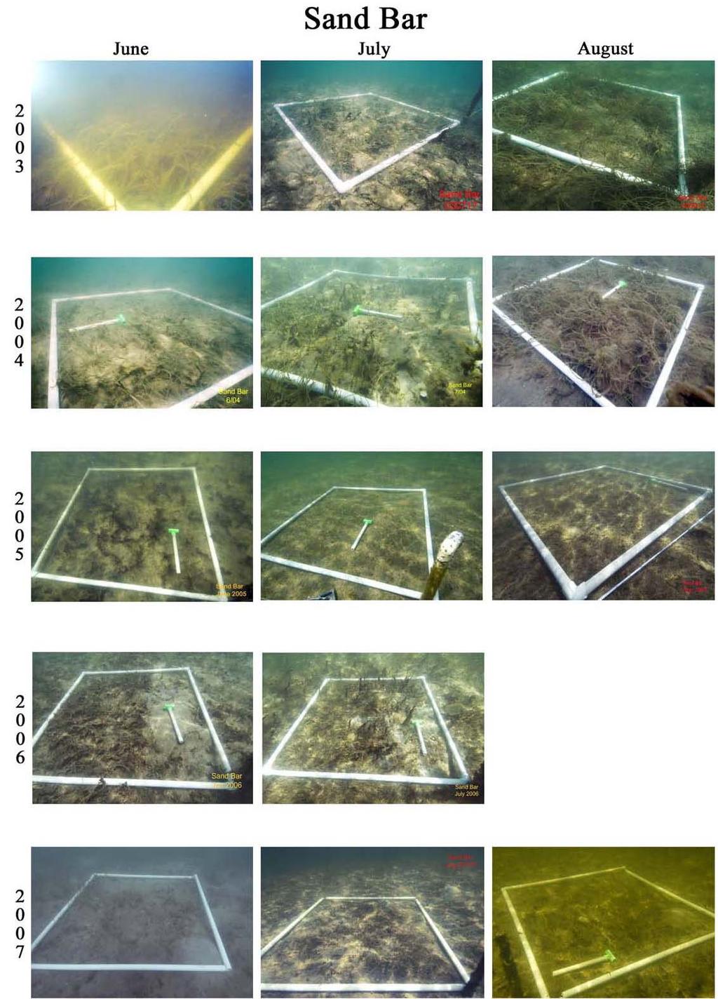
8 8 scale and to orient north in the photo. Unfortunately, water clarity was not sufficient to permit the collection of photographs each month, though every attempt was made to revisit the seagrass beds at high tide when this occurred. Because the photos were taken at the same position each month, a valuable visual record of the status and seasonal changes of the seagrasses has been documented. The photographic record for the peak growing season months June, July, and August is provided for the years in Appendix A. Concurrent with seagrass data collection, physical and chemical water quality parameters were evaluated and freshwater discharge into the system was recorded. Throughout the study, temperature, conductivity, salinity, dissolved oxygen, ph, turbidity, chlorophyll a, and Photosynthetic Available Radiation (PAR) were recorded monthly at the time of seagrass sampling in the channel adjacent to each seagrass site and at a site in the middle of each seagrass bed. Furthermore, data from RiverKeeper water quality stations 4 and 42 (central embayment) and 25 (Hobe Sound) provide bi-monthly assessments of nutrients in the vicinity of the seagrass sampling sites. Starting in April 24, salinity, temperature, and depth were recorded every 15 min at the NB and PP sites using a Hydrolab Minisonde 4a positioned at seagrass canopy height (~ 25 cm off the bottom). A Hydrolab Minisonde 4a positioned at seagrass canopy height was added to the Hobe Sound reference seagrass bed in January 26. Water quality samples were processed following Standard Methods by the Loxahatchee River District s Wildpine Laboratory, which is certified under the National Environmental Laboratory Accreditation Program. Photosynthetically active radiation (PAR) was assessed by taking 3 replicates of PAR using 3 LI-COR spherical sensors (4 π) simultaneously located at 2 cm, 5 cm, and 1 cm below the water surface. Data were recorded on a LI-COR LI-14 data logger. Light attenuation coefficient (Kd) was calculated as the slope of natural log transformed PAR values regressed against depth. Following Kemp et al. (24), the percent of light passing through the water column to seagrasses (PLW) was calculated as PLW = 1 exp [(-Kd)(Z)], where Kd is the light attenuation coefficient and Z is the depth of seagrass growth. Freshwater discharge into the Southwest Fork was recorded continuously at the S-46 structure, while freshwater discharge into the Northwest Fork was recorded continuously at Lainhart Dam. Discharge from the North Fork generally contributes approximately 6% of mean daily flow into the estuary and was not assessed during this period (SFWMD 26).
9 9 Results The primary purpose of this paper is to understand the dynamics of seagrasses in the Loxahatchee River Estuary prior to the September 24 storms (i.e., the natural range of variability), and to understand the temporal progression of seagrasses recovery following a largescale disturbance. While a separate manuscript (Ridler et al. 26) identified salinity variability as the most likely mechanism that resulted in the observed decline in S. filiforme, the present report will focus more broadly on the temporal and spatial dynamics of seagrasses prior to and following the September 24 storms. Percent Occurrence Prior to the September 24 storms, S. filiforme showed relatively little variability in percent occurrence at the Loxahatchee River central embayment sampling sites (Figure 2). Syringodium filiforme typically occurred in ~6% of North Bay samples, 3-4% of Sand Bar samples, and % of Pennock Point samples. It is important to note that S. filiforme appears always to be absent from the western portions of the Loxahatchee River central embayment, and was never observed in any Pennock Point samples (Figure 2). Following the September 24 storms, S. filiforme showed both immediate (Sand Bar) and gradual (North Bay) decline in percent occurrence (Figure 3A), though the trend appears to have reversed and S. filiforme has shown a slow, gradual increase since December 25. Although sampling was only begun in June 25 at the Hobe Sound reference site, the relatively high and constant abundance suggest S. filiforme did not suffer any appreciable declines following the September 24 storms. Furthermore, the stability of the post-storm occurrence values at Hobe Sound (around 7%) is quite similar to the pre-storm stability observed at North Bay, which suggests Hobe Sound represents a suitable reference site independent of the effects of Loxahatchee River freshwater discharge. Halodule wrightii was found to be the first or second most abundant seagrass at all four sampling sites, and it was the least affected by the September 24 storms (Figure 2). Prior to September 24, H. wrightii occupied 25% to 78% of quadrats at each of the seagrass sampling locations. Its relative abundance appears to be somewhat moderated by the abundance of S. filiforme, i.e., when S. filiforme occurrence was low or absent then H. wrightii occurrence was highest, but when S. filiforme occurrence was high then H. wrightii occurrence was lower.
10 1 1 North Bay Manatee Grass Shoal Grass Johnson's Grass Percent Occurrence Sand Bar Percent Occurrence Pennock Point Percent Occurrence Percent Occurrence Hobe Sound J-3 J-3 A-3 S-3 O-3 N-3 D-3 F-4 M-4 A-4 M-4 A-4 S-4 O-4 N-4 D-4 F-5 M-5 A-5 M-5 A-5 S-5 O-5 N-5 D-5 F-6 M-6 A-6 M-6 A-6 S-6 O-6 N-6 D-6 F-7 M-7 A-7 M-7 A-7 Figure 2. After 35 months manatee grass in the Loxahatchee River did not fully recover from the excessive freshwater discharges that occurred in 24. The similarity in seagrass occurrence between North Bay prior to the 24 storms and the Hobe Sound site following the storms is striking, and suggests the Hobe Sound site is an excellent reference site that is independent of the effects of S-46 flood control discharges. Note the differences among Loxahatchee River sites across the upstreamdownstream gradient (eg. from North Bay to Pennock Point). The vertical dotted line indicates the occurrence of the 24 storms (vertical dotted line). Error bars represent ± 1 Standard Error.
11 11 Following the September 24 storms, H. wrightii showed a slight and immediate decline in occurrence, but began an immediate and sustained recovery at North Bay and Sand Bar sites (Figure 2). In fact, Figure 3B shows that at North Bay and Sand Bar sites H. wrightii occurred in a larger fraction of quadrats in the post-disturbance period when compared to the pre-disturbance period. Nonetheless, H. wrightii has shown only the slightest margin of recovery at Pennock Point; occurrence values remained relatively constant since October 24. Importantly, throughout the 35 months of post-disturbance monitoring occurrence of H. wrightii at Pennock Point remained below pre-disturbance levels (Figure 3B). The occurrence of H. wrightii at the reference site (Hobe Sound) has increased steadily from around 25% in December 25 to approximately nearly 65% in August 27. Halophila johnsonii, the federally threatened seagrass, has shown the greatest variability in occurrence among sampling sites over the monitoring period. Prior to the disturbance of the September 24 storms, H. johnsonii was most frequently encountered at the Sand Bar site and least abundant at North Bay (Figure 2), though occurrence at these sites was strongly seasonal. For example, H. johnsonii occurred in 2% of Sand Bar samples at the end of the 23 summer, increased to 8% of samples in March 24, and declined to 3% of samples in August 24. This seasonal pattern of occurrence suggests a winter-spring growth period, and is repeated at North Bay and Sand Bar over the and periods. It should be noted that immediately following the September 24 storms, H. johnsonii disappeared from Pennock Point and did not recover until November 26, 26 months following the disturbance (Figure 3D). Finally, data appear to suggest that occurrence of H. johnsonii can be suppressed by S. filiforme, which has a much taller canopy. If prolific beds of S. filiforme shade out H. johnsonii, which seems very likely, then the effect of the storms on S. filiforme may have indirectly benefited H. johnsonii by opening up space and increasing light availability. Finally, it should be noted that H. johnsonii is able to grow at shallower depths than other seagrass species in the Loxahatchee River Estuary and is often encountered at the shallowest edge of bed. This is particularly noticeable at the Sand Bar site. The most diverse site within the Loxahatchee River Estuary has historically been North Bay. In addition to S. filiforme, H. wrightii, and H. johnsonii, Thalassia testudinum, Halophila decipiens, and Halophila engelmanni were observed at this site prior to the September 24 storms. Following the disturbance, T. testudinum, H. decipiens, and H. engelmanni disappeared
12 12 from our transect samples and they have not returned, though they have been observed in North Bay off the established transect lines. A Percent Change 1% 8% 6% 4% 2% % -2% -4% -6% -8% -1% Manatee Grass Percent Occurence Sand Bar North Bay Pennock Point B Percent Change 125% 1% 75% 5% 25% % -25% -5% Shoal Grass Percent Occurence Jun-3 Sep-3 Dec-3 Mar-4 Jun-4 Sep-4 Dec-4 Mar-5 Jun-5 Sep-5 Dec-5 Mar-6 Jun-6 Sep-6 Dec-6 Mar-7 Jun-7 Jun-3 Sep-3 Dec-3 Mar-4 Jun-4 Sep-4 Dec-4 Mar-5 Jun-5 Sep-5 Dec-5 Mar-6 Jun-6 Sep-6 Dec-6 Mar-7 Jun-7 C Johnson's Grass Percent Occurence D Johnson's Grass Percent Occurence Percent Change 25% 2% 15% 1% 5% % -5% Percent Change 35% 3% 25% 2% 15% 1% 5% % -5% -1% -15% Jun-3 Sep-3 Dec-3 Mar-4 Jun-4 Sep-4 Dec-4 Mar-5 Jun-5 Sep-5 Dec-5 Mar-6 Jun-6 Sep-6 Dec-6 Mar-7 Jun-7 Jun-3 Sep-3 Dec-3 Mar-4 Jun-4 Sep-4 Dec-4 Mar-5 Jun-5 Sep-5 Dec-5 Mar-6 Jun-6 Sep-6 Dec-6 Mar-7 Jun-7 Figure 3. Seagrass recovery trajectories based on relative percent change show site-specific and speciesspecific patterns of recovery. Percent occurrence values for each species at each monitoring location were referenced against observed occurrence values for each species at each monitoring location over the 12 month pre-disturbance period (June 23 through May 24). Note that values below zero (e.g., manatee grass) represent a decrease in occurrence relative to pre-disturbance conditions, and positive values (e.g., Johnson s grass) represent an increase in occurrence relative to pre-disturbance conditions. Shoot Density & Canopy Height Similar to occurrence data, observed seagrass shoot densities suggest a relatively natural, seasonal range of variability prior to the September 24 storms (Figure 4). Probably more interesting is the dichotomy between the response of S. filiforme and H. wrightii following the disturbance. Canopy height and shoot density of S. filiforme show a significant decline following the storms (Figure 4A and 4B, North Bay and Sand Bar), while H. wrightii does not appear to be negatively affected by the 24 storms (Figure 4C and 4D). Canopy height of S. filiforme appears to make a full recovery by the spring of 26 (Figure 4B, Figure 5A), approximately 18 months following the disturbance. While S. filiforme shoot densities increased
13 13 during the summer months of 26, these values remain far below the peak values observed prior to the 24 storms (Figure 5B). The seasonal variability of H. wrightii and S. filiforme shoot densities and canopy height reflect seasonal cycles consistent with observations of these species in other areas of the Indian River Lagoon (Gilbert and Clark 1981) and may be responding to warmer temperatures, though increased light availability may also explain the pattern (Short et. al. 1993). Across all Loxahatchee River Estuary sites, seagrass shoot density, as measured for S. filiforme or H. wrightii, is at its lowest during the winter months (November February) when the water is cooler and the photoperiod shorter, and is at its peak late summer when water temperatures are warmer and day length is longer. Mean shoot density (m -2 ) A North Bay Sand Bar Hobe Sound Mean canopy height (cm) 35 B North Bay Sand Bar Hobe Sound Mean shoot density (m -2 ) C Pennock Point J-3 J-3 A-3 S-3 O-3 N-3 D-3 F-4 M-4 A-4 M-4 A-4 S-4 O-4 N-4 D-4 F-5 M-5 A-5 M-5 A-5 S-5 O-5 N-5 D-5 F-6 M-6 A-6 M-6 A-6 S-6 O-6 N-6 D-6 F-7 M-7 A-7 M-7 A-7 Mean canopy height (cm) D Pennock Point J-3 J-3 A-3 S-3 O-3 N-3 D-3 F-4 M-4 A-4 M-4 A-4 S-4 O-4 N-4 D-4 F-5 M-5 A-5 M-5 A-5 S-5 O-5 N-5 D-5 F-6 M-6 A-6 M-6 A-6 S-6 O-6 N-6 D-6 F-7 M-7 A-7 M-7 A-7 Figure 4. Seagrass shoot density and canopy height reveal impacts of the 24 storms (vertical dotted line) as well as seasonal peaks due to the summer growing season. It appears that the health of individual plants, measured as canopy height, has recovered more completely than the health of the population, which may be inferred from shoot density estimates. Note that Syringodium filiforme was assessed at North Bay, Sand Bar, and Hobe Sound while Halodule wrightii was assessed at Pennock Point (S. filiforme was absent there). Error bars represent ± 1 Standard Error.
14 14 A 2% Canopy Height Sand Bar North Bay Pennock Point B 15% Shoot Density Percent Change 15% 1% 5% % -5% -1% Jun-3 Oct-3 Feb-4 Jun-4 Oct-4 Feb-5 Jun-5 Oct-5 Feb-6 Jun-6 Oct-6 Feb-7 Jun-7 Figure 5. Relative percent change of canopy height (A) and shoot density (B) at three Loxahatchee River seagrass monitoring locations. At North Bay and Sand Bar S. filiforme was assessed, while H. wrightii was assessed at Pennock Point because S. filiforme does not occur there. Canopy height recovered relatively quickly following the disturbances of 24. The response of shoot density was species specific. H. wrightii recovered within three months, while S. filiforme did not recover even after 35 months. Percent Change 1% 5% % -5% -1% Jun-3 Oct-3 Feb-4 Jun-4 Oct-4 Feb-5 Jun-5 Oct-5 Feb-6 Jun-6 Oct-6 Feb-7 Jun-7 Biomass Seagrass biomass is a function of the relative abundance (occurrence), shoot density, canopy height, and the amount of energy stored in below ground roots. Peak seagrass biomass was typically observed in August (Figure 6) when shoot density and blade lengths are at their peak. Prior to the September 24 storms, a considerable amount of among site variability was observed. For example, peak biomass was nearly 15 g m -2 at North Bay but it was only 67 g m - 2 at Sand Bar and 16 g m -2 at Pennock Point. Much of the disparity between North Bay and Pennock Point is because S. filiforme is absent from Pennock Point and Halodule wrightii constitutes 1% of the seagrass biomass at that site. In August 24, immediately prior to the September 24 storms, seagrass biomass was nearly identical at North Bay and Sand Bar (~66 g m -2 ), though Pennock Point supported only 6.7 g m -2 of seagrass biomass at this time. Following the September 24 storms, seagrass biomass declined to near zero and the majority of seagrass biomass collected since the storms has been due to the accumulation of H. wrightii. Interestingly, the reference site in Hobe Sound shows a similar biomass trend from August 25 through August 26 that was quite similar to that observed at North Bay during the period August 23 through August 24.
15 15 2 North Bay Manatee Grass Shoal Grass Johnson's Grass Biomass (g m -2 ) Sand Bar Biomass (g m -2 ) Pennock Point Biomass (g m -2 ) Hobe Sound Biomass (g m -2 ) A-3 S-3 O-3 N-3 D-3 F-4 M-4 A-4 M-4 A-4 S-4 O-4 N-4 D-4 F-5 M-5 A-5 M-5 A-5 S-5 O-5 N-5 D-5 F-6 M-6 A-6 M-6 A-6 S-6 O-6 N-6 D-6 F-7 M-7 A-7 M-7 A-7 Figure 6. Seagrass biomass shows a typical seasonal trend of increasing during the summer and decreasing during the winter. In the Loxahatchee River manatee grass comprises the majority of seagrass biomass in beds in which it occurs; however, given its limited distribution, shoal grass likely provides more biomass system-wide. Note the reduction in biomass (especially manatee grass) following the 24 storms. Error bars represent ± 1 Standard Error.
16 16 Discussion Ongoing seagrass monitoring in the Loxahatchee River Estuary has provided interesting insights into the ecology and dynamics of seagrasses in South Florida, and has yielded novel insights into how and when seagrasses are stressed by excessive freshwater discharges (Ridler et al. 26). Based on LRD s seagrass monitoring in 2 and 22 (Ridler et al. 23), the monitoring period August 23 through August 24 appears to represent a relatively normal period (i.e., no lagging negative effects due to excessive freshwater), and serves as a baseline to understand natural variability in the system. Similarly, ongoing monitoring in the southern Indian River Lagoon (Hobe Sound) serves as a reference site that is relatively immune to excessive freshwater discharges. By comparing the pre-disturbance period and the reference site, we can better understand natural seasonal dynamics of seagrasses in the southern Indian River Lagoon and the Loxahatchee River Estuary. In addition, because seagrass monitoring has continued without interruption for 35 months following the September 24 storms, these data provide excellent documentation of seagrass recovery following an extreme disturbance in the form of excessive winds and freshwater discharge. For example, these data show the near complete loss of S. filiforme following the storms of September 24. Subsequent to these storms, June 25 was an unusually wet season followed by hurricane Wilma in October 25. Throughout the postdisturbance monitoring period substantial changes to the composition of all three of the monitored Loxahatchee River seagrass beds have been documented. At North Bay, three species, Thalassia testudinum, Halophila engelmanni, and H. decipiens, disappeared. We documented the occurrence of Halophila johnsonii, an opportunistic species, to increase to over 2,% of its pre-disturbance levels, though these excessive gains have been reduced as other species have recovered. We also documented the near extinction and current recovery of S. filiforme from the Sand Bar monitoring site while H. wrightii and H. johnsonii continued to proliferate there. Also documented is the local extinction, reemergence, and sustained slow recovery of H. johnsonii at the Pennock Point site while H. wrightii remained essentially unchanged throughout the sampling period. In particular, these data suggest the occurrence of Halodule wrightii and Halophila johnsonii may be dynamically influenced by both freshwater discharges, i.e., salinity regime and water quality, and competition with S. filiforme for light. Furthermore, these data clearly demonstrate the long time periods necessary for seagrasses to recover following such
17 17 large and extensive losses. For example, it took approximately 26 months for H. johnsonii to completely recover at Pennock Point, and yet after 35 months S. filiforme has not completely recovered at North Bay or Sand Bar. Furthermore, in the 35 months following the September 24 storms it appears that the health of individual plants (i.e., inferred from canopy height) has recovered more completely than the health of the population (i.e., inferred from shoot density and biomass). Ridler et al. (26) suggested that secondary stressors such as sulfide toxicity or disease acting on stressed S. filiforme likely drove the long-term decline observed for S. filiforme at North Bay and Sand Bar. Indeed, if sulfide toxicity or a disease agent affected the health of S. filiforme, a full recovery of seagrasses at North Bay and Sand Bar may be quite slow. Based upon the current trends of seagrasses at the reference site and in the Loxahatchee River Estuary, it appears that seagrass beds within the Loxahatchee River Estuary are on their way to recovery following the September 24 storms. Given the dynamic and slow nature of seagrass recovery, we suggest every effort should be made to minimize excessive flood control releases to the Loxahatchee River Estuary. In particular, it appears that more frequent discharges of smaller volume may be less stressful than fewer, larger discharges. Nonetheless, severe, natural disturbances such as hurricanes are a part of the natural environmental forces that shape estuaries, and their impacts, while disturbing, likely can not be avoided. Literature Cited Catchpole, W. R. and C. J. Wheeler Estimating plant biomass: a review of techniques. Australian Journal of Ecology 17: CERP (Comprehensive Everglades Restoration Plan). 21. Baseline Report for the Comprehensive Everglades Restoration Plan. South Florida Water Management District, West Palm Beach, Florida. Duarte, C. M. and H. Kirkman. 21. Methods for the measurement of seagrass Abundance and depth distribution. In Global Seagrass Research Methods (F.T. Short and R.G. Coles, ed) Elsevier Science, B.V. Fourqurean, J. W., A. Willsie, C. D. Rose and L. M. Rutten. 21. Spatial and temporal pattern in seagrass community composition and productivity in south Florida. Marine Biology 138: Gilbert, S. and K. B. Clark Seasonal variation in standing crop of the seagrass Syringodium filiforme and associated macrophytes in the northern Indian River, Florida. Estuaries 4:
18 Holmquist, J. G., G. V. N. Powell and S. M. Sogard Decapod and stomatopod assemblages on a system of seagrass-covered mud banks in Florida Bay. Marine Biology 1: Kemp, W. M., R. Batiuk, R. Bartleson, P. Bergstrom, V. Carter, C. Gallegos, W. Hunley, L. Karrh, E. W. Koch, J. M. Landwehr, K. A. More, L. Murray, M. Naylor, N. B. Rybicki, J. C. Stevenson and D. J. Wilcox. 24. Habitat requirements for submerged aquatic vegetation in Chesapeake Bay: Water quality, light regime, and Physical-chemical factors. Estuaries 27: Lirman, D. and W. P. Cropper Jr. 23. The influence of Salinity on Seagrass Growth, Survivorship and Distribution within Biscayne Bay, Florida: Field, Experimental and Modeling Studies. Estuaries 26: Montague, C. L. and J. A. Ley A possible effect of salinity fluctuation on abundance of benthic vegetation and associated fauna in Northeastern Florida Bay. Estuaries 16: Provancha, J. A. and D. M. Scheidt. 2. Long-term trends in seagrass beds in the Mosquito Lagoon and Northern Banana River, Florida, In S. A. Bortone (ed.), Seagrasses: Monitoring, Ecology, Physiology and Management. CRC Press, Boca Raton, FL. Ridler, M. S., R. C. Dent and D. A. Arrington. 26. Effects of two hurricanes on Syringodium filiforme, manatee grass, within the Loxahatchee River Estuary, Southeast Florida. Estuaries and Coasts 29: In Press. Ridler, M. S., R. C. Dent and L. R. Bachman. 23. Viability and variability of seagrass communities in the Loxahatchee Estuary and associated reach of the Indian River Lagoon 1998, 2, 22. Loxahatchee River District, Unpublished Report. Short, F. T., J. Montgomery, C. F. Zimmermann and C. A. Short Production and Nutrient Dynamics of Syringodium filiforme Kutz. Seagrass bed in Indian River Lagoon, Florida. Estuaries 16: SFWMD. 26. Restoration Plan for the Northwest Fork of the Loxahatchee River. South Florida Water Management District, West Palm Beach, Florida. Zieman, J. C The ecology of the seagrasses of south Florida: A community profile. Unites States Fish and Wildlife Service, Office of Biological Services, Washington D.C. FWS/OBS- 82/ pp. Zieman, J. C., J. W. Fourqurean and R. L. Iverson Distribution, abundance and productivity of seagrasses and macroalgae in Florida Bay. Bulletin of Marine Science 44:

19 Appendix A. Time series photographs of North Bay and Sand Bar seagrass sampling stations. 19
20 2
21 21 Appendix B. The enclosed compact disk contains the full LRPI dataset for the sampling period (October 26 through September 27). If you have any questions regarding this dataset, please contact Albrey Arrington (telephone: x17; or Lorene Bachman (telephone: x143;
LOXAHATCHEE RIVER SEAGRASS MONITORING & MAPPING REPORT DRAFT TASK 4: FINAL REPORT. In Partial Fulfillment of Agreement No
 LOXAHATCHEE RIVER SEAGRASS MONITORING & MAPPING REPORT DRAFT TASK 4: FINAL REPORT In Partial Fulfillment of Agreement No. 4600001907 For the Period October 2009 through September 2010 Respectfully Submitted
LOXAHATCHEE RIVER WATER QUALITY AND BIOLOGICAL MONITORING TASK 2: FINAL REPORT ASSESSMENT OF LOXAHATCHEE RIVER OYSTER MAPPING & RECRUITMENT
 LOXAHATCHEE RIVER WATER QUALITY AND BIOLOGICAL MONITORING TASK 2: FINAL REPORT ASSESSMENT OF 2007-2008 LOXAHATCHEE RIVER OYSTER MAPPING & RECRUITMENT In Partial Fulfillment of Agreement No. 4600001281
Florida Seagrass Integrated Mapping and Monitoring Program
 Florida Seagrass Integrated Mapping and Monitoring Program - 2004 The following document is composed of excerpts taken from the 2011 publication, Seagrass Integrated Mapping and Monitoring for the State
FIU Digital Commons. Florida International University. Henry O. Briceño Florida International University,
 Florida International University FIU Digital Commons SERC Research Reports Southeast Environmental Research Center 2015 Water Quality Monitoring Project for Demonstration of Canal Remediation Methods Florida
Seagrass surveys must be conducted between the dates of April 1 st and October 31 st with the following exceptions:
 Florida Fish and Wildlife Conservation Commission (FWC) Recommended Survey Protocols for Estuarine and Marine Submerged Aquatic Vegetation (SAV) related to Permitting Applications 12/14/2011 DRAFT 1) Survey
Indian River Lagoon: Lessons, Challenges and Opportunities
 Indian River Lagoon: Lessons, Challenges and Opportunities Upper Chain of Lakes Lake Kissimmee Kissimmee River Indian River Lagoon Caloosahatchee Estuary Lake Okeechobee St. Lucie Estuary Mark Perry, Executive
Volume and Shoreline Changes along Pinellas County Beaches during Tropical Storm Debby
 Volume and Shoreline Changes along Pinellas County Beaches during Tropical Storm Debby Ping Wang and Tiffany M. Roberts Coastal Research Laboratory University of South Florida July 24, 2012 Introduction
STATUS REPORT FOR THE SUBMERGED REEF BALL TM ARTIFICIAL REEF SUBMERGED BREAKWATER BEACH STABILIZATION PROJECT FOR THE GRAND CAYMAN MARRIOTT HOTEL
 August 23 STATUS REPORT FOR THE SUBMERGED REEF BALL TM ARTIFICIAL REEF SUBMERGED BREAKWATER BEACH STABILIZATION PROJECT FOR THE GRAND CAYMAN MARRIOTT HOTEL performed by Lee E. Harris, Ph.D., P.E. Consulting
EcoLogic Memorandum. TO: Ben Brezell; EDR FROM: Mark Arrigo RE: Possible Impacts of Dredging Snooks Pond DATE: 6/4/07
 EcoLogic Memorandum TO: Ben Brezell; EDR FROM: Mark Arrigo RE: Possible Impacts of Dredging Snooks Pond DATE: 6/4/07 Background EDR P.C. (EDR) has been contracted by a landowner to assess the feasibility
FISHERIES BLUE MOUNTAINS ADAPTATION PARTNERSHIP
 FISHERIES A warming climate, by itself, substantially affects the hydrology of watersheds in the Blue Mountains. Among the key hydrologic changes projected under all scenarios for the 2040s and beyond
MISSISSIPPI MAKEOVER A Plan for Restoration, Just Around the Bend
 MISSISSIPPI MAKEOVER A Plan for Restoration, Just Around the Bend Interim Report Card 2013 Project coordinated by the Dakota County Soil and Water Conservation District and sponsored by the Minnesota Pollution
Habitat Fact Sheets. Rocky habitats are dominated by seaweeds and often mussels, which rely on the rocks for attachment.
 Habitat Fact Sheets Habitats in the Gulf of Maine serve many important roles for the environment and for humans as well. These include: cycling nutrients, filtering pollution, trapping sediments, storing
Fraser River. FISH SURVEY AND MANAGEMENT INFORMATION Jon Ewert - Aquatic Biologist (Hot Sulphur Springs)
") Fraser River FISH SURVEY AND MANAGEMENT INFORMATION Jon Ewert - Aquatic Biologist (Hot Sulphur Springs) General Information: The Fraser River is a highly diverse river offering many transitions in habitat
Fraser River FISH SURVEY AND MANAGEMENT INFORMATION Jon Ewert - Aquatic Biologist (Hot Sulphur Springs) General Information: The Fraser River is a highly diverse river offering many transitions in habitat
Refined Designated Uses for the Chesapeake Bay and Tidal Tributaries
 A-1 appendixa Refined Designated Uses for the Chesapeake Bay and Tidal Tributaries BACKGROUND Federal water quality standards regulations establish that states must specify appropriate water uses to be
Cove Point Beach Restoration: Utilization of a Spawning Habitat by Horseshoe Crabs (Limulus polyphemus)
") Cove Point Beach Restoration: Utilization of a Spawning Habitat by Horseshoe Crabs (Limulus polyphemus) Paul Bushmann, Jessica Peterson, Bethany Enyeart and Deborah Smith Anne Arundel Community College
Cove Point Beach Restoration: Utilization of a Spawning Habitat by Horseshoe Crabs (Limulus polyphemus) Paul Bushmann, Jessica Peterson, Bethany Enyeart and Deborah Smith Anne Arundel Community College
Seagrasses Along the Texas Coast:
 Seagrasses Along the Texas Coast: Using GIS to Examine Differences from 2011-2012 Sara Wilson 12/07/2012 Department of Marine Science University of Texas at Austin CE 394K GIS in Water Resources Wilson
Warm-up # 7 A day 5/17 - B day 5/18 UPDATE YOUR TABLE OF CONTENTS
 Warm-up # 7 A day 5/17 - B day 5/18 UPDATE YOUR TABLE OF CONTENTS Question: List all examples of surface water on Earth. Answer: Rivers and streams, lakes and reservoirs, (ponds) wetlands, estuaries and
Collaborative. City of Stuart. September 7, Mark Perry, Executive Director Oceanographic Society. Upper Chain of Lakes
 Lake Okeechobee Collaborative Upper Chain of Lakes Lake Kissimmee Indian River Lagoon City of Stuart September 7, 2016 Kissimmee River Caloosahatchee Estuary Lake Okeechobee St. Lucie Estuary Everglades
SARASOTA BAY ESTUARY PROGRAM OYSTER HABITAT MONITORING RESULTS: YEAR 1. Jay R. Leverone
 SARASOTA BAY ESTUARY PROGRAM OYSTER HABITAT MONITORING RESULTS: YEAR 1 by Jay R. Leverone Mote Marine Laboratory 1600 Ken Thompson Parkway Sarasota, Fl 34236 to Gary Raulerson Sarasota Bay Estuary Program
Jason Blackburn, Paul Hvenegaard, Dave Jackson, Tyler Johns, Chad Judd, Scott Seward and Juanna Thompson
 Alberta Conservation Association (ACA) Date: 2014-2015 Project Name: Owl River Walleye and Aquatic Habitat Assessment Fisheries Program Manager: Peter Aku Project Leader: Tyler Johns Primary ACA staff
An Update of Coastal Erosion in Puerto Rico
 Jack Morelock and Maritza Barreto An Update of Coastal Erosion in Puerto Rico Department of Marine Sciences, University of Puerto Rico at Mayagüez and Geography Department, University of Puerto Rico at
Environmental. Effects of Dredging
 Envi~onmental Effects of Dredging Technical Notes THE VALUE OF GRAVEL DISPOSAL MOUNDS IN RIVER SIDE CHANNELS FOR FRESHWATER MUSSELS PURPOSE: This note provides information on the value of gravel disposal
Figure 4, Photo mosaic taken on February 14 about an hour before sunset near low tide.
 The Impact on Great South Bay of the Breach at Old Inlet Charles N. Flagg and Roger Flood School of Marine and Atmospheric Sciences, Stony Brook University Since the last report was issued on January 31
SECTION 2 HYDROLOGY AND FLOW REGIMES
 SECTION 2 HYDROLOGY AND FLOW REGIMES In this section historical streamflow data from permanent USGS gaging stations will be presented and discussed to document long-term flow regime trends within the Cache-Bayou
Distribution and Viability of Oyster Communities in the Loxahatchee River Estuary
 Distribution and Viability of Oyster Communities in the Loxahatchee River Estuary February, 2004 Lorene R. Bachman, Mary S. Ridler and Richard C. Dent WildPine Ecological Laboratory Loxahatchee River District
IMPACTS OF COASTAL PROTECTION STRATEGIES ON THE COASTS OF CRETE: NUMERICAL EXPERIMENTS
 IMPACTS OF COASTAL PROTECTION STRATEGIES ON THE COASTS OF CRETE: NUMERICAL EXPERIMENTS Tsanis, I.K., Saied, U.M., Valavanis V. Department of Environmental Engineering, Technical University of Crete, Chania,
Currents measurements in the coast of Montevideo, Uruguay
 Currents measurements in the coast of Montevideo, Uruguay M. Fossati, D. Bellón, E. Lorenzo & I. Piedra-Cueva Fluid Mechanics and Environmental Engineering Institute (IMFIA), School of Engineering, Research
Estuarine Shoreline Stabilization
 Estuarine Shoreline Stabilization Property Owner s Guide to Determining the Most Appropriate Stabilization Method Estuarine shorelines are dynamic features that experience continued erosion. Land is lost
Co-Principal Investigators Stephen C. Jewett, Ph.D. Paul C. Rusanowski, Ph.D.
 PROGRESS REPORT FACTORS AFFECTING NEARSHORE SURVIVAL AND PRODUCTION OF JUVENILE SOCKEYE SALMON FROM KVICHAK BAY Phase I: Important habitat, migration routes and food resources CoPrincipal Investigators
Properties. terc.ucdavis.edu 8
 Physical Properties 8 Lake surface level Daily since 1900 The lowest lake level on record was 6,220.26 feet on Nov. 30, 1992. Since 1900, lake level has varied by more than 10 feet. Lake level typically
FLORIDA BAY: AN ECOSYSTEM ON THE BRINK
 E V E R G L A D E S R E S T O R A T I O N F A C T S H E E T FLORIDA BAY: AN ECOSYSTEM ON THE BRINK Background T he Florida Bay estuary is located at the southern edge of the Everglades ecosystem at the
7.4 Temperature, Salinity and Currents in Jamaica Bay
 7.4 Temperature, Salinity and Currents in Jamaica Bay Arnold Gordon, Bruce Huber and Robert Houghton 7.4.1 INTRODUCTION Jamaica Bay stratification is weakly indicative of a shallow, tidally active environment,
Redd Dewatering and Juvenile Salmonid Stranding in the Lower Feather River,
 Redd Dewatering and Juvenile Salmonid Stranding in the Lower Feather River, 2005-2006 Interim Report for NOAA Fisheries Prepared by: California Department of Water Resources Division of Environmental Services
Crooked Lake Oakland County (T4N, R9E, Sections 3, 4, 9) Surveyed May James T. Francis
 Surveyed May James T. Francis") Michigan Department of Natural Resources Status of the Fishery Resource Report No. 2004-1, 2004 Crooked Lake Oakland County (T4N, R9E, Sections 3, 4, 9) Surveyed May 2002 James T. Francis Environment Crooked
Michigan Department of Natural Resources Status of the Fishery Resource Report No. 2004-1, 2004 Crooked Lake Oakland County (T4N, R9E, Sections 3, 4, 9) Surveyed May 2002 James T. Francis Environment Crooked
Inlet Management Study for Pass-A-Grille and Bunces Pass, Pinellas County, Florida
 Inlet Management Study for Pass-A-Grille and Bunces Pass, Pinellas County, Florida Final Report Submitted By Ping Wang, Ph.D., Jun Cheng Ph.D., Zachary Westfall, and Mathieu Vallee Coastal Research Laboratory
Warner Lakes Redband Trout
 Warner Lakes Redband Trout Existing Populations Warner Valley is an endorheic basin that contains a complex series of interconnected lakes, marshes, sloughs, and potholes, all of which are remnants of
MARTINDALE POND Wayne County 2004 Fish Management Report. Christopher C. Long Assistant Fisheries Biologist
 MARTINDALE POND Wayne County 2004 Fish Management Report Christopher C. Long Assistant Fisheries Biologist Fisheries Section Indiana Department of Natural Resources Division of Fish and Wildlife I.G.C.
Seagrass Surveys in Kampot
 Coastal Annual Forum 23 rd October 2014 Sihanoukville, Cambodia Seagrass Surveys in Kampot Presentation by Louis Bourne INTERNATIONAL UNION FOR CONSERVATION OF NATURE Presentation Overview Location and
Puget Sound Shorelines. Waves and coastal processes. Puget Sound shorelines: Effects of beach armoring
 Puget Sound Shorelines Puget Sound shorelines: Effects of beach armoring Waves and coastal processes Factors affecting wave energy hitting the coast Processes transporting sediment along coastlines What
MIDDLE FORK RESERVOIR Wayne County 2004 Fish Management Report. Christopher C. Long Assistant Fisheries Biologist
 MIDDLE FORK RESERVOIR Wayne County 2004 Fish Management Report Christopher C. Long Assistant Fisheries Biologist FISHERIES SECTION INDIANA DEPARTMENT OF NATURAL RESOURCES DIVISION OF FISH AND WILDLIFE
X.B WETLANDS ROGUE RIVER ESTUARY
 X.B WETLANDS ROGUE RIVER ESTUARY The Rogue River has a drainage area of 5,100 square miles, yet the estuary of the Rogue River is one of the smallest in Oregon, measuring approximately 1,880 acres during
Seagrasses of the Virgin Islands
 Seagrasses of the Virgin Islands Seagrasses are flowering plants that live underwater. These marine plants resemble the land species of grasses in that they have long blade-like leaves. Seagrasses grow
Summary Report for Sarasota Bay
 Summary Report for Sarasota Bay Contacts: Jay Leverone, Sarasota Bay Estuary Program Jon Perry and Rene Janneman, Sarasota County Greg Blanchard, Manatee County Kristen Kaufman, Southwest Florida Water
CHAPTER 11.1 THE WORLD OCEAN MARINE BIOMES NOTES
 CHAPTER 11.1 THE WORLD OCEAN MARINE BIOMES NOTES 1. The world ocean can be divided into zones both and. The,, and zones that apply to large lakes also apply to the ocean. 2. In addition to the depth zones,
Final Bull Trout Redd Monitoring Report for the Wallowa Falls Hydroelectric Project
 Final for the Wallowa Falls Hydroelectric Project East Fork Wallowa River barrier to upstream fish migration, photo courtesy of Kendrick Moholt (FERC No. P-308) December 18, 2017 Prepared by: Jeremiah
Marine Ecosystems. Aquatic Ecosystems Section 2
 Marine Ecosystems Marine ecosystems are located mainly in coastal areas and in the open ocean. Organisms that live in coastal areas adapt to changes in water level and salinity. Organisms that live in
EVALUATING THE EFFECTS OF BIVALVE SHELLFISH AQUACULTURE AND ITS ECOLOGICAL ROLE IN THE ESTUARINE ENVIRONMENT IN THE UNITED STATES
 EVALUATING THE EFFECTS OF BIVALVE SHELLFISH AQUACULTURE AND ITS ECOLOGICAL ROLE IN THE ESTUARINE ENVIRONMENT IN THE UNITED STATES Brett Dumbauld USDA Agricultural Research Service, Hatfield Marine Science
Removal of natural obstructions to improve Atlantic Salmon and Brook Trout habitat in western NL. 26/02/2015 Version 2.0
 Removal of natural obstructions to improve Atlantic Salmon and Brook Trout habitat in western NL 26/02/2015 Version 2.0 1 Table of Contents List of Tables... 2 Introduction... 3 Methods... 4 Preliminary
Minnesota Department of Natural Resources Division of Fish and Wildlife Section of Fisheries. Stream Survey Report. Luxemburg Creek.
 Minnesota F-29-R(P)-24 Area 315 Study 3 March 2016 Minnesota Department of Natural Resources Division of Fish and Wildlife Section of Fisheries Stream Survey Report Luxemburg Creek 2015 Mark Pelham Sauk
Yale Reservoir Kokanee (Oncorhynchus nerka) Escapement Report 2016
 Escapement Report 2016") Yale Reservoir Kokanee (Oncorhynchus nerka) Escapement Report 2016 North Fork Lewis River Hydroelectric Project Yale FERC No. 2071 Prepared by: Jeremiah Doyle, PacifiCorp April 4, 2017 1.0 INTRODUCTION
Yale Reservoir Kokanee (Oncorhynchus nerka) Escapement Report 2016 North Fork Lewis River Hydroelectric Project Yale FERC No. 2071 Prepared by: Jeremiah Doyle, PacifiCorp April 4, 2017 1.0 INTRODUCTION
UNDERSTANDING YOUR ESTUARY Level IA- ESTUARY SEARCH
 UNDERSTANDING YOUR ESTUARY Level IA- ESTUARY SEARCH Kakagon/Bad River Sloughs, a Lake Superior estuary located on the Bad River Reservation near Ashland, WI. GOAL Select one Wisconsin estuary to study
Beach profile surveys and morphological change, Otago Harbour entrance to Karitane May 2014 to June 2015
 Beach profile surveys and morphological change, Otago Harbour entrance to Karitane May 2014 to June 2015 Prepared for Port Otago Ltd Martin Single September 2015 Shore Processes and Management Ltd Contact
Nortek Technical Note No.: TN-021. Chesapeake Bay AWAC Evaluation
 Nortek Technical Note No.: TN-021 Title: Chesapeake Bay AWAC Evaluation Last Edited: October 5, 2004 Authors: Eric Siegel-NortekUSA, Chris Malzone-NortekUSA, Torstein Pedersen- Number of Pages: 12 Chesapeake
Eelgrass and Macroalgae Presence/Absence Preliminary Surveys BHP Proposed Grays Harbor Potash Export Facility A Task 400
 Memorandum 40600-HS-MEM-55036 Revision 0 Date: 26 July 2018 Subject: Eelgrass and Macroalgae Presence/Absence Preliminary Surveys BHP Proposed Grays Harbor Potash Export Facility A17.0202.00 Task 400 INTRODUCTION
Job Title: Game Management, Subsection B Game Management Mountain Lion
 Job Title:, Subsection B Goal: Manage the mountain lion population, its numbers and distribution, as an important part of Arizona s fauna and to provide mountain lion hunting recreation opportunity while
Seagrasses: Vital Habitat in Texas Estuaries
 Seagrasses: Vital Habitat in Texas Estuaries Cindy Hobson Water Resources Branch Coastal Fisheries Division Texas Parks and Wildlife Department February 17, 2015 Why Care About Seagrass? Sustain coastal
NURSERY POND Fish Management Report. Jason C. Doll Assistant Fisheries Biologist
 NURSERY POND 2004 Fish Management Report Jason C. Doll Assistant Fisheries Biologist FISHERIES SECTION INDIANA DEPARTMENT OF NATURAL RESOURCES DIVISION OF FISH AND WILDLIFE I.G.C. South, Room W273 402
Green Sturgeon Feeding Observations in Humboldt Bay, California
 Green Sturgeon Feeding Observations in Humboldt Bay, California Matt Goldsworthy 1, Bill Pinnix, Miles Barker 1, Liz Perkins 1, Aaron David, Jeffrey Jahn 1 Introduction Understanding the distribution,
Oceans Humans both depend on it and threaten it with their activities
 Oceans Humans both depend on it and threaten it with their activities Oceans Water covers nearly ¾ of the Earth s surface More than 50% of the world s population lives within an hour of the coast Oceans
Texas Water Resources Institute
 Texas Water Resources Institute November/December 1982 Volume 8 No. 6 A Precise Environment By Lou Ellen Ruesink, Editor, Texas Water Resources Aquarium enthusiasts know just how particular fish are about
THE SEAGRASS LANDSCAPE OF BUNDAS MARINE PROTECTED AREA, BARANGAY BAGUMBAYAN, LUPON, DAVAO ORIENTAL, PHILIPPINES
 THE SEAGRASS LANDSCAPE OF BUNDAS MARINE PROTECTED AREA, BARANGAY BAGUMBAYAN, LUPON, DAVAO ORIENTAL, PHILIPPINES Presented by: Cirilo O. Ybaňez Jr. 1, Kris Vallerie A. Oñate 2 Davao Oriental of State College
Catlow Valley Redband Trout
 Catlow Valley Redband Trout Existing Populations The Catlow Valley Redband Trout SMU is comprised of five populations (Table 1). Three exist in Home, Threemile, and Skull creeks, located on the east side
Klamath Lake Bull Trout
 Klamath Lake Bull Trout Existing Populations The Klamath Lake Bull Trout SMU is comprised of seven existing populations and four populations classified as extinct or functionally extinct (Table 189). Populations
Status and Distribution of the Bobcat (Lynx rufus) in Illinois
 in Illinois") Transactions of the Illinois State Academy of Science received 9/14/99 (2000), Volume 93, #2, pp. 165-173 accepted 1/16/00 Status and Distribution of the Bobcat (Lynx rufus) in Illinois Alan Woolf 1, Clayton
Transactions of the Illinois State Academy of Science received 9/14/99 (2000), Volume 93, #2, pp. 165-173 accepted 1/16/00 Status and Distribution of the Bobcat (Lynx rufus) in Illinois Alan Woolf 1, Clayton
Delaware Chapter Surfrider Foundation - Indian River Inlet Monitoring
 Delaware Chapter Surfrider Foundation - Indian River Inlet Monitoring In 2012, the Delaware Surfrider Foundation Chapter formed the Surf Quality and Access Committee to focus on issues such as surf spot
Figure 1: Map showing the relative location of the study sub-watersheds in Plymouth (south) and Maple Grove (north), MN.
 and Maple Grove (north), MN.") II. Grass clippings Methods Grass clippings from residential lawns have frequently been cited as a significant source of nutrients and organic matter transported to receiving waters from residential developments.
II. Grass clippings Methods Grass clippings from residential lawns have frequently been cited as a significant source of nutrients and organic matter transported to receiving waters from residential developments.
Water Quality Guidelines for Total Gas Pressure: First Update
 Water Quality Water Quality Guidelines for Total Gas Pressure: First Update Overview Report Prepared pursuant to Section 2(e) of the Environment Management Act, 1981 Approved: Date Assistant Deputy Minister
SURGE SUPPRESSION ACHIEVED BY DIFFERENT COASTAL SPINE (IKE DIKE) ALIGNMENTS. Bruce A. Ebersole, Thomas W. Richardson and Robert W.
 ALIGNMENTS. Bruce A. Ebersole, Thomas W. Richardson and Robert W.") SURGE SUPPRESSION ACHIEVED BY DIFFERENT COASTAL SPINE (IKE DIKE) ALIGNMENTS Abstract Bruce A. Ebersole, Thomas W. Richardson and Robert W. Whalin, Jackson State University, Jackson, Mississippi The primary
SURGE SUPPRESSION ACHIEVED BY DIFFERENT COASTAL SPINE (IKE DIKE) ALIGNMENTS Abstract Bruce A. Ebersole, Thomas W. Richardson and Robert W. Whalin, Jackson State University, Jackson, Mississippi The primary
Dry Disturbance and Fish Reduction Produce Enhanced Crayfish Densities in a Freshwater Wetland
 Dry Disturbance and Fish Reduction Produce Enhanced Crayfish Densities in a Freshwater Wetland Nathan J. Dorn Florida Atlantic University Davie, FL Mark I. Cook South Florida Water Management District
ATTACHMENT F. Minnesota Department of Natural Resources. Marsh Lake Ecosystem Restoration Project
 ATTACHMENT F Minnesota Department of Natural Resources Marsh Lake Ecosystem Restoration Project Mussel Rescue and Translocation Plan for Pomme de Terre River Restoration (Prepared June, 2016) Attachment
Protect Our Reefs Grant Interim Report (October 1, 2008 March 31, 2009) Principal investigators: Donald C. Behringer and Mark J.
 Principal investigators: Donald C. Behringer and Mark J.") Investigating the role of the spotted spiny lobster (Panulirus guttatus) in the recovery of the long spined sea urchin (Diadema antillarum) on the coral reefs of the Florida Keys Protect Our Reefs Grant
Investigating the role of the spotted spiny lobster (Panulirus guttatus) in the recovery of the long spined sea urchin (Diadema antillarum) on the coral reefs of the Florida Keys Protect Our Reefs Grant
Figure 1. Schematic illustration of the major environments on Mustang Island.
 STOP #1: PACKERY CHANNEL BEACH TO BAY We will start this field guide near the north jetty of Packery Channel and hike across the island to Corpus Christi Bay (fig. 1). The island emerges from the Gulf
The Impact on Great South Bay of the Breach at Old Inlet Charles N. Flagg School of Marine and Atmospheric Sciences, Stony Brook University
 The Impact on Great South Bay of the Breach at Old Inlet Charles N. Flagg School of Marine and Atmospheric Sciences, Stony Brook University The previous report provided a detailed look at the conditions
Managing Chesapeake Bay s Land Use, Fish Habitat, and Fisheries: Studies. Jim Uphoff & Margaret McGinty, Fisheries Service
 Managing Chesapeake Bay s Land Use, Fish Habitat, and Fisheries: Positive Image and or Negative Graphic Case Studies Jim Uphoff & Margaret McGinty, Fisheries Service Maryland Fisheries Service has been
South Amelia Island Shore Stabilization Project- Beach Renourishment
 South Amelia Island Shore Stabilization Project- Beach Renourishment Evaluation of Beach Nourishment Impacts to Beach Indicator Species Spring 2013 Year 2 Post-Construction Final Report USACE Permit No.
11426 Moorage Way P.O. Box 368 LaConner, WA Phone: Fax:
 Skagit River System Cooperative 11426 Moorage Way P.O. Box 368 LaConner, WA 98257-368 Phone: 36-466-7228 Fax: 36-466-447 www.skagitcoop.org BULL TROUT USE OF SWINOMISH RESERVATION WATERS Eric Beamer, Rich
Oceanic Society Reef Research Team: Nicole Crane, Avigdor Abelson, Peter Nelson, Giacomo Bernardi, Michelle Paddack, Kate Crosman
 The coral reef of Tamil (Yap, FSM): Preliminary ecological assessment of reef state and fish assemblages, and potential of conservation for sustainable use Report compiled by vigdor belson, Peter Nelson
Figure 1, Chart showing the location of the Breach at Old Inlet and sensors deployed in Great South Bay.
 The Impact on Great South Bay of the Breach at Old Inlet Charles N. Flagg and Roger Flood School of Marine and Atmospheric Sciences, Stony Brook University The Great South Bay project (http://po.msrc.sunysb.edu/gsb/)
Near-Field Sturgeon Monitoring for the New NY Bridge at Tappan Zee. Quarterly Report July 1 September 30, 2014
 Near-Field Sturgeon Monitoring for the New NY Bridge at Tappan Zee Quarterly Report July 1 September 30, 2014 Prepared by AKRF, Inc. 7250 Parkway Drive, Suite 210 Hanover, MD 21076 for New York State Thruway
Big Bend Oyster Research
 Big Bend Oyster Research Drs. Jennifer Seavey, Bill Pine, & Peter Frederick Department of Wildlife Ecology and Conservation, Institute of Food and Agricultural Sciences, 110 Newins-Ziegler Hall, PO Box
Longshore Bar Creation: a viable option for seagrass restoration?
 Longshore Bar Creation: a viable option for seagrass restoration? Lindsay M. Cross, Tampa Bay Estuary Program Holly Greening, Tampa Bay Estuary Program Michael Seifert, Tampa Port Authority Susan Burtnett,
FACT SHEET MCGREGOR LAKE RESTORATION HABITAT PROJECT POOL 10, UPPER MISSISSIPPI RIVER, WISCONSIN ENVIRONMENTAL MANAGEMENT PROGRAM
 FACT SHEET MCGREGOR LAKE RESTORATION HABITAT PROJECT POOL 10, UPPER MISSISSIPPI RIVER, WISCONSIN ENVIRONMENTAL MANAGEMENT PROGRAM LOCATION McGregor Lake is located within a mid-river island in Pool 10
SOCIETAL GOALS TO DETERMINE ECOSYSTEM HEALTH: A FISHERIES CASE STUDY IN GALVESTON BAY SYSTEM, TEXAS
 SOCIETAL GOALS TO DETERMINE ECOSYSTEM HEALTH: A FISHERIES CASE STUDY IN GALVESTON BAY SYSTEM, TEXAS Anthony S. Pait, NOAA, National Centers for Coastal Ocean Science Thomas P. O Connor, David R. Whitall,
Hydrological Condition Report including the issues of High Flow Fluctuation in Chiang Saen
 Hydrological Condition Report including the issues of High Flow Fluctuation in Chiang Saen Technical Symposium for ESCIR and MRC on Social Impact Assessment in River Basin Management Sothea KHEM, HENG
Coastal management has lagged behind the growth in population leading to problems with pollution
 Fifty percent of the population of the industrialized world lives within 100 km of a coast. Coastal management has lagged behind the growth in population leading to problems with pollution and natural
LONE TREE POCKET ESTUARY RESTORATION 2004 FISH SAMPLING AND PRE-RESTORATION PROJECT MONITORING REPORT
 Skagit River System Cooperative 11426 Moorage Way P.O. Box 368 LaConner, WA 98257-368 Phone: 36-466-7228 Fax: 36-466-447 www.skagitcoop.org LONE TREE POCKET ESTUARY RESTORATION 24 FISH SAMPLING AND PRE-RESTORATION
Phase II Final Report Port Canaveral Lionfish Project
 Phase II Final Report Port Canaveral Lionfish Project Contract PO # P14685 Report prepared for Carol Noble Director, Environmental Plans and Programs Canaveral Port Authority Suite 301 445 Challenger Road
This presentation focuses on: 1. The results of the first four years of compliance monitoring of the Wheeler North Reef, 2. An evaluation of the
 This presentation focuses on: 1. The results of the first four years of compliance monitoring of the Wheeler North Reef, 2. An evaluation of the Wheeler North Reef in 2012 with respect to the performance
MESSOLOGI LAGOON AREA (GREECE)
") MESSOLOGI LAGOON AREA (GREECE) 20 Contact: Kyriakos SPYROPOULOS TRITON Consulting Engineers 90 Pratinou Str. 11634 Athens (GREECE) Tel: +32 10 729 57 61 Fax: +32 10 724 33 58 e-mail: kspyropoulos@tritonsa.gr
MESSOLOGI LAGOON AREA (GREECE) 20 Contact: Kyriakos SPYROPOULOS TRITON Consulting Engineers 90 Pratinou Str. 11634 Athens (GREECE) Tel: +32 10 729 57 61 Fax: +32 10 724 33 58 e-mail: kspyropoulos@tritonsa.gr
ATLANTIC STATES MARINE FISHERIES COMMISSION. Winter Flounder Abundance and Biomass Indices from State Fishery-Independent Surveys
 ATLANTIC STATES MARINE FISHERIES COMMISSION Winter Flounder Abundance and Biomass Indices from State Fishery-Independent Surveys Technical Committee Report to the Winter Flounder Management Board February
Justification for Rainbow Trout stocking reduction in Lake Taneycomo. Shane Bush Fisheries Management Biologist Missouri Department of Conservation
 Justification for Rainbow Trout stocking reduction in Lake Taneycomo Shane Bush Fisheries Management Biologist Missouri Department of Conservation December 14, 2017 Lake Taneycomo was formed by the construction
CHAPTER 4 DESIRED OUTCOMES: VISION, GOALS, AND OBJECTIVES
 CHAPTER 4 DESIRED OUTCOMES: VISION, GOALS, AND OBJECTIVES Vision One of the first steps in developing this Plan was articulating a vision - a clear statement of what the Plan strives to achieve and what
Eulachon: State of the Science and Science to Policy Forum
 Eulachon: State of the Science and Science to Policy Forum August 27, 2015 Robert Anderson Eulachon Recovery Coordinator National Marine Fisheries Service FCRPS, Dams, and Water Management in the Columbia
Initial recovery of flora and fauna at restored mosquito impoundments in Indian River Lagoon, FL
 Initial recovery of flora and fauna at restored mosquito impoundments in Indian River Lagoon, FL Melinda Donnelly PhD Candidate, University of Central Florida Ron Brockmeyer, Linda Walters, William Greening,
Blue crab ecology and exploitation in a changing climate.
 STAC Workshop 28 March 2017 Blue crab ecology and exploitation in a changing climate. Thomas Miller Chesapeake Biological Laboratory University of Maryland Center for Environmental Science Solomons, MD
INLAND LAKE MANAGEMENT REPORT FY Spring 2008
 INLAND LAKE MANAGEMENT REPORT FY 2008 Spring 2008 Prepared by Robert O. Andress District Fisheries Biologist E. Daniel Catchings District Fisheries Supervisor Kevin W. Baswell District Biologist Aide Department
Conservation and Restoration Florida s Coastal Marshes: An Overview of MESS. Jeff Beal, Kent Smith, Erin McDevitt, Maria Merrill
 Conservation and Restoration Florida s Coastal Marshes: An Overview of MESS Jeff Beal, Kent Smith, Erin McDevitt, Maria Merrill FWC s MESS: -Marine/Estuarine Subsection -within Aquatic Habitat Conservation
Distribution of the Atlantic Bottlenose Dolphin (Tursiops truncatus) in the Chesapeake Bay Drainage in Virginia
 in the Chesapeake Bay Drainage in Virginia") Banisteria, Number 11, 1998 33 1998 by the Virginia Natural History Society Distribution of the Atlantic Bottlenose Dolphin (Tursiops truncatus) in the Chesapeake Bay Drainage in Virginia Thomas F. Wilcox
Banisteria, Number 11, 1998 33 1998 by the Virginia Natural History Society Distribution of the Atlantic Bottlenose Dolphin (Tursiops truncatus) in the Chesapeake Bay Drainage in Virginia Thomas F. Wilcox
SALINITY. It's the amount of dissolved salts the water contains.
 AQUATIC ECOSYSTEMS SALINITY The types of organisms in an aquatic ecosystem depend upon the water s Salinity. It's the amount of dissolved salts the water contains. Salinity determines the two main aquatic
The Impact on Great South Bay of the Breach at Old Inlet Charles N. Flagg School of Marine and Atmospheric Sciences, Stony Brook University
 The Impact on Great South Bay of the Breach at Old Inlet Charles N. Flagg School of Marine and Atmospheric Sciences, Stony Brook University This is the sixth in a series of reports describing the evolution