|
|
|
- Darlene Alicia Walsh
- 5 years ago
- Views:
Transcription
1
2
3
4
5
6
7
8
9
10
11


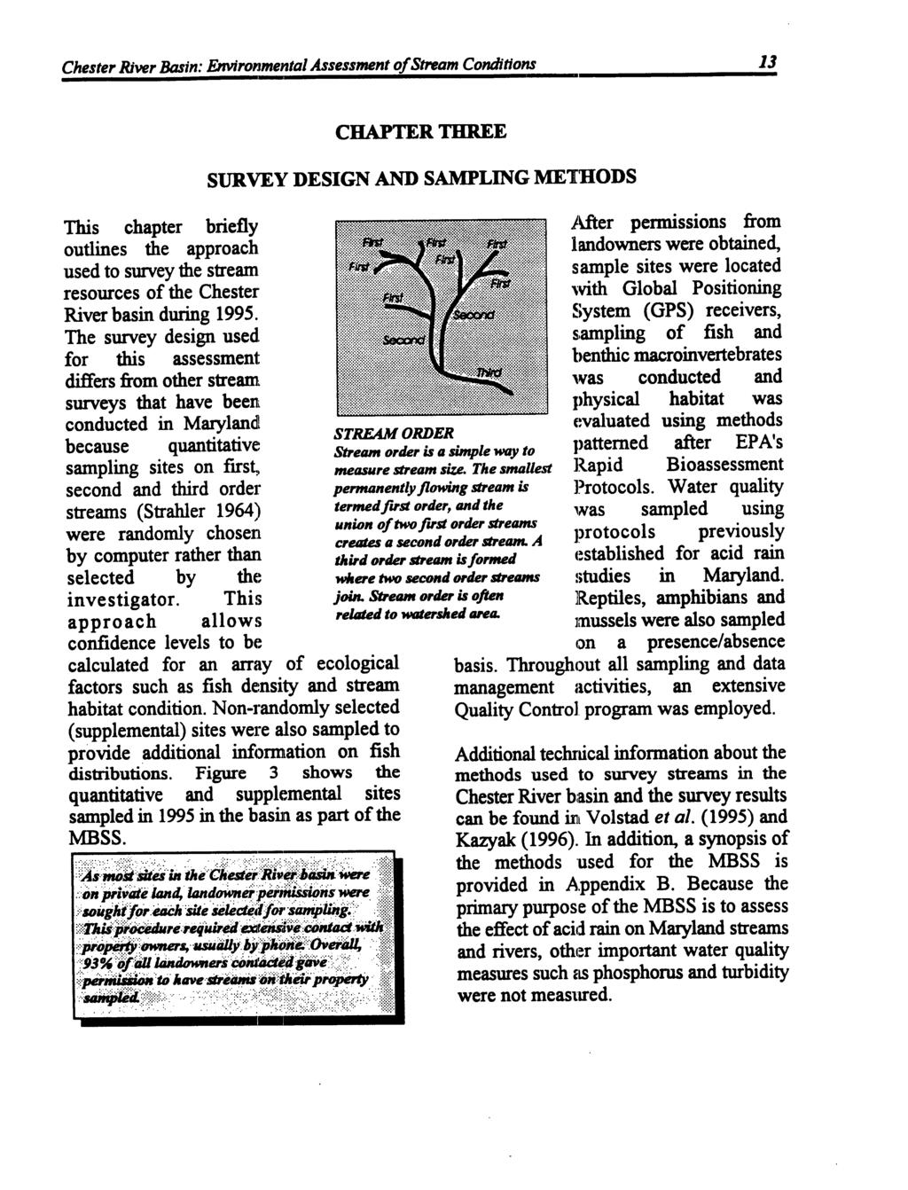
12 example, the abundance of a given fish species in a basin can be validly estimated using the MBSS design. Because first, second, and third order streams represent about 90% of the tidal and non-tidal stream miles in the Chester River basin, MBSS results should accurately represent overall stream quality in the basin. Examination of conditions in small streams also enables identification of specific problem areas where local protection, enhancement,and restoration efforts could be focused. To provide sorne cornparison of present and past conditions, historical information is presented where appropriate and available. In addition, information on land use, hydrology and other aspects of the basin are also represented so that observed conditions in streams can be placed in context.
13


.")
. Soils range from well drained to poorly drained.")


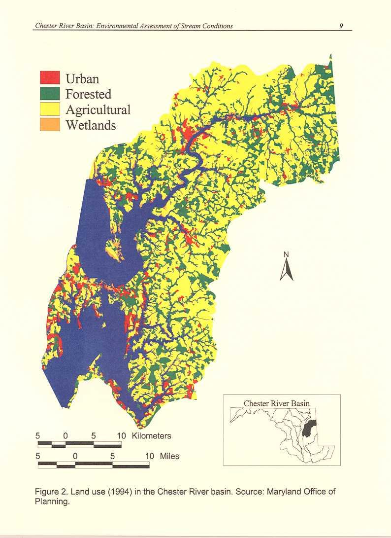
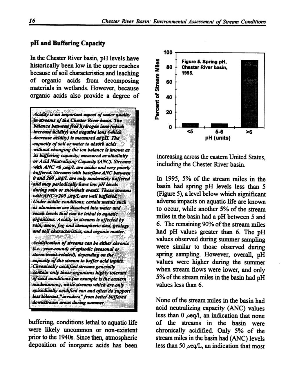
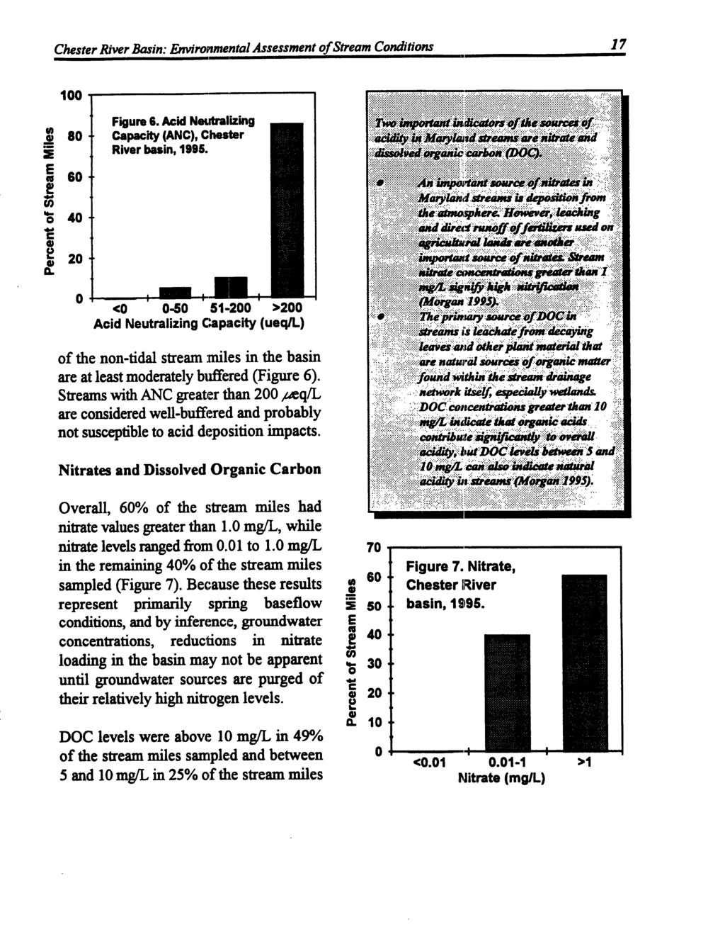
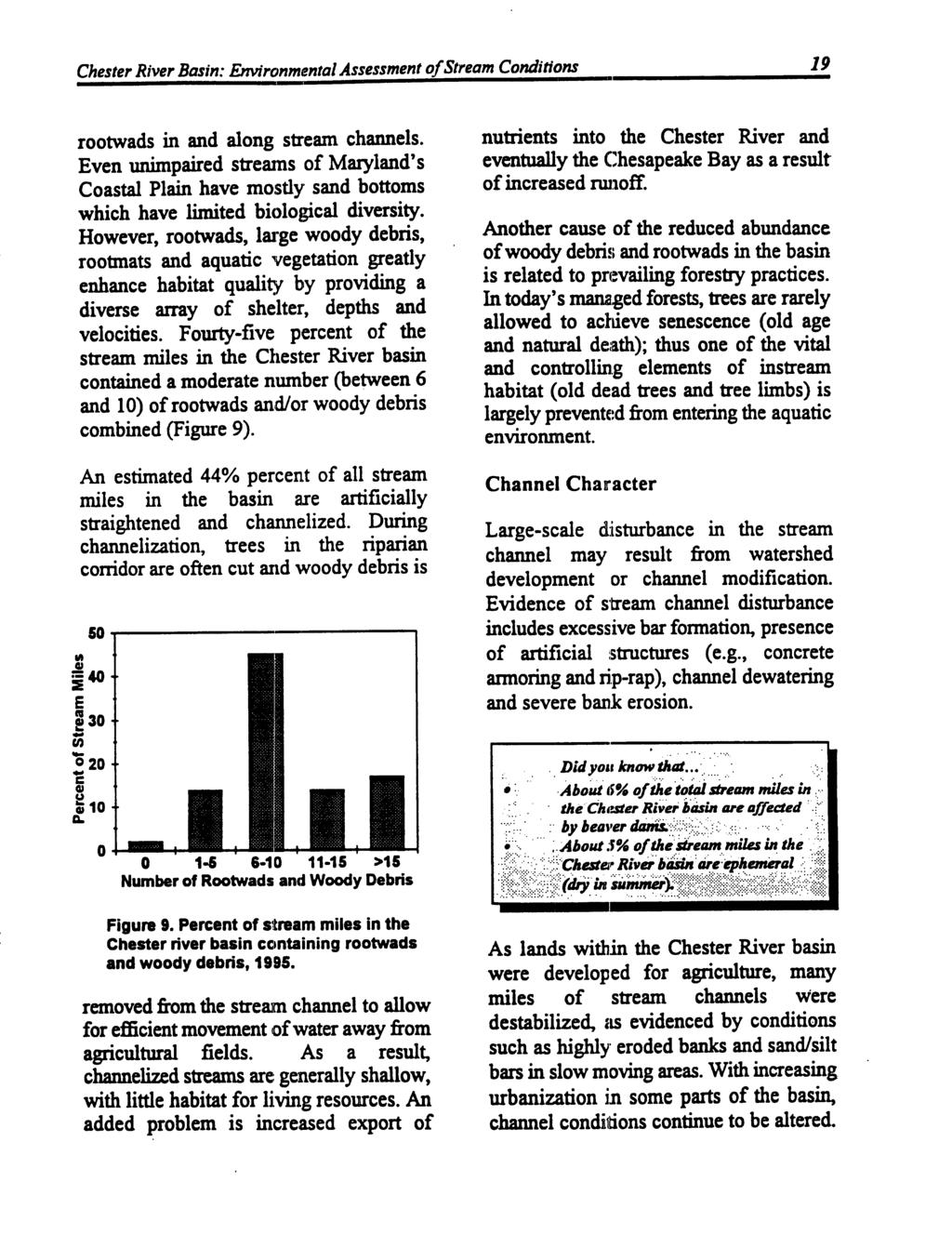
14 8 Chester River Basin: Environmental Assessment of Stream Conditions The lower part of the basin is dominated by stands of American beech, tulip poplar, red and white oak, hickory, VIrginia and loblolly pine. The upper portion is dominated by red maple, sweetlblack gum, swamp-white oak, swamp chestnut, southern red/pin/willow oak, green ash and sycamore. Because land in the Chester River basin is gently sloping and often near sea level, substantial areas are immersed during rainy periods. To make poorly drained areas suitable for agriculture, a large percentage of the streams in the basin were historically channelized. Today, many of the well drained areas are used for agriculture, while many poorly drained, more natural areas remain forested. Because of the chronic wetness of these bottomlands, trees are slow-growing and of limited commercial value. Conversely, these wet areas have high value as wildlife habitat (Batchelor 1996). The soils of the basin originate primarily from parent material of unconsolidated deposits of clays, silts, sands and gravels deposited as either coastal plain or alluvial delta (USDA 1982). Soils range from well drained to poorly drained. The climate in the basin is generally humid and mild, with an average annual temperature of55 F and an average daily maximum in the summer of 840 F at Chestertown, MD. The mean annual precipitation is 43 inches. Precipitation is evenly distributed throughout the year: monthly averages have ranged from 3 inches in February to 4 inches in June (Perez 1996). There is a total of 291 miles of first, second and third order non-tidal streams in the basin. First order streams make up 74% of the total non-tidal stream miles. while second and third order streams constitute 22% and 4% of the non-tidal stream miles. respectively. The three largest lakes in the basin are Urieville Lake (34 acres), Unicorn Lake (45 acres) and Wye Mills Community Lake (50 acres). All are publicly-owned and are classified as eutrophic (Fewlass 1983). LAND USE More than half (51 %) of the total acreage in the basin is used for agriculture, 21 % is classified as forest and another 21% is under water (Eastern Bay){Figures 1 and 2). Kent County, which lies between the Figure 1. Land use in the Chester River basin is predominantly agricultural. When considering only dry land, nearly 65% of the area is used for field crops or dairy operations (USDA 1982).
15
16
17
18
19
20
21
22
23

24
25
26

27
28

, eastern mudminnow, 36%; golden shiner, 10%;tessellated followed by the darter, 10%; bluegill, 9%; redfin pickerel, 5% and American eel, 5 %.")
 was represented by six species, while the perch family (Percidae) was represented by three species. Various other families were represented by only one or two species.")


29 and frequency of OCCUlTence for each American HI species of fish collected dwing MBSS sampling in Figure 12 shows the relative abundance of the six Ott..r' most abundant species in the basin. Consistent with the presence of only wannwater habitat Golden shiner in the Chester basin, Bluegill.Redftn pickerelfigure the sunfish famil y Relative abundance of the six most abundant fishspecies (Centrarchidae) had the in the Chester River basin (quantitative samples only),1995. greatest number of fi,sh Six species accounted for 750/. of the estimated totalabundance: species (eight), eastern mudminnow, 36%; golden shiner, 10%;tessellated followed by the darter, 10%; bluegill, 9%; redfin pickerel, 5% and American eel, 5 %. The eastern mudminnow was collected at the minnow family greatest number of sites (89%). (Cyprinidae) with seven species. The catfish family (Ictaluridae) was represented by six species, while the perch family (Percidae) was represented by three species. Various other families were represented by only one or two species. Eastern mud minnow basin-wide abundance of about 2,000 individuals. Only 2% of the chain pickerel were of leg a! size (14 inches or larger). Rare and Uncommon Species Gamefish Two species of gamefish, largemouth bass and chain pickerel, were collected in the Chester River basin. Largemouth bass were the most abundant gamefish collected, with an estimated density of almost 250 per stream mile. The estimated basin-wide abundance of largemouth bass was about 70,000 individuals, comprised primarily of young- of-year. Less than 1% of the largemouth bass collected were of legal size (12 inches or larger). The density of chain pickerel was estimated at nine per stream mile, with an estimated None of the species of fish collected during 1995 are listed as threatened, rare, or endangered by either Maryland or the U.S. Fish and Wildlife Service. However, the status of the swamp darter, Etheostoma fusiforme, is under review by the State of Maryland (Davidson 1996). Prior to this study, swamp darters had been found at only one Maryland site on the Western Shore. Otherwise, they were thought to be restricted to Maryland's lower Eastern Shore. A map of swamp darter distribution along with distributions of all other fish species taken in 1995 is shown in Appendix E.
30
31
32

33


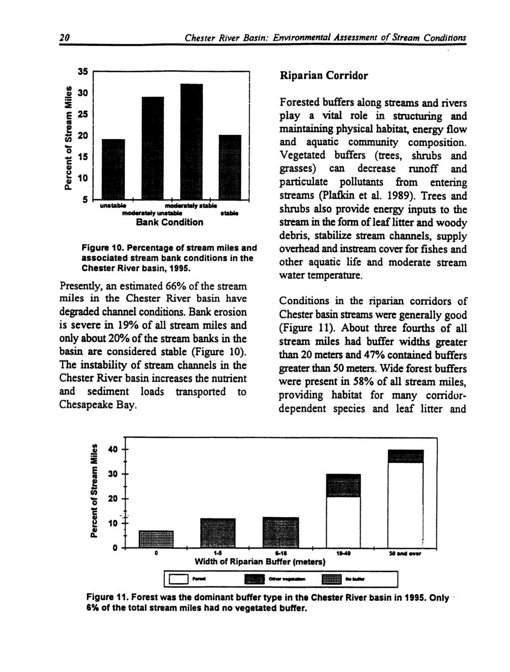
34 100 GI U C ~ = uu 0 ~ F"'8 ~ PIc--Frwg Species _L- C-~T- Figure 16. Percent occurrence of the five most commonly observ.ed amphibians ~nd rept~le~ for sampled streams In the Chester RIver basin In bull frog and pickerel frog were by far the most common species, occulting at 74%, 69% and 56% of the sites, respectively (Figure 16). Although the Eastern tiger salamander, Barking treefrog and Carpenter frog are rare, threatened or endangered species known to occur in the Chester River basin, none were found during the 1995 survey. SUMMARY OF STREAM RESOURCE CONnmONS Acid-related water quality in Chester River basin streams was generally good. Only a small percentage of streams were the streams very acidic. in the basin Most are of well buffered and few stream miles are chronically acidified. Sources of acidity in stream water can include acid rain and dissolved organic carbon from wetlands. The low gradient of streams and nutrient-rich runoff from agricultural lands likely work in concert to produce low dissolved oxygen levels in about one half of the stream miles in the basin. More than half the stream miles in the basin had degraded instream habitats. Destruction of vegetated riparian buffers, channelization, excessive siltation and groundwater withdrawal all likely contribute to these degraded conditions. COMMON SNAPPING TURTLE The common snapping tiirtle (Chelydra serpentina) was fo"nd at 1 " of the sites in the Chester River basin in This species is adive day and night dilring warmer months and prefer milddy-bottomed creeks and weedy shallows. The fish community sampled in the nontidal portion of the Chester River basin in 1995 was relatively diverse. Species richness was moderately high (37 species) and two species of gamefish were collected (largemouth bass and chain pickerel). However, die fish community was numerically dominated by pollutiontolerant eastern mudminnows. With the exception of the American eel, few migratory fish were present. However, there are 137 known barriers to migration


 are not native to the Chesapeake Bay drainage, although they are naturalized.")


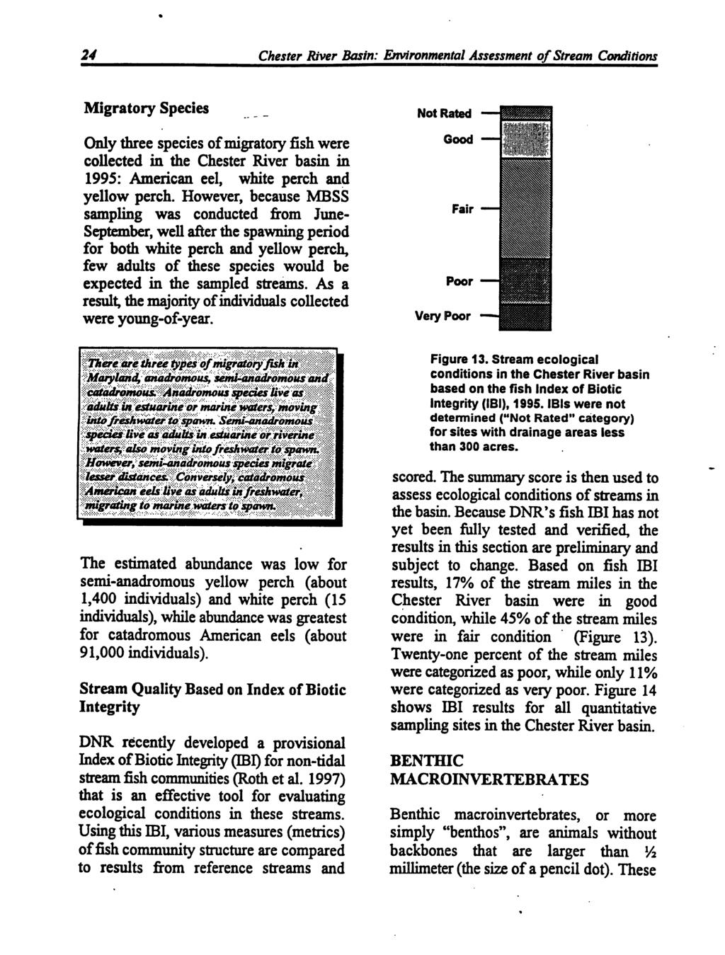
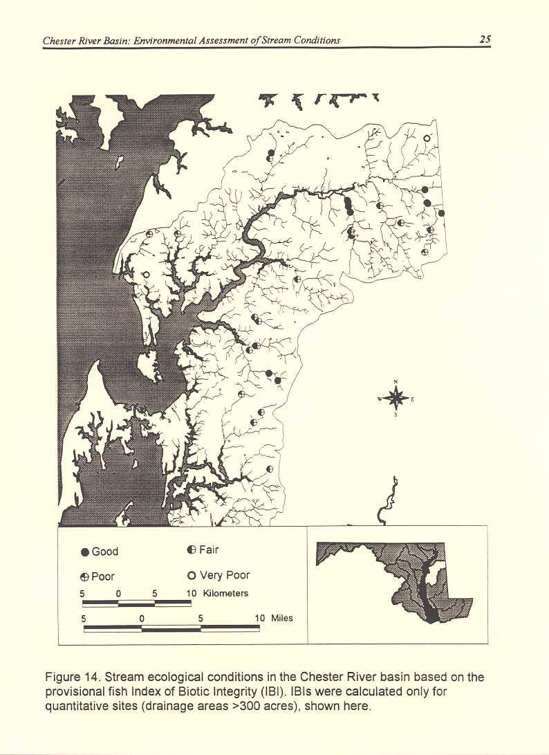
35 Chester River Basin: Environmental Assessment of Stream Conditions 29 -'--'-. ~-- - changed over time. The 1995 MBSS results establish a useful bench mark of cuitent fish species compositio~ distribution and abundance that can be used to track future changes. Figure 17. Barriers to fish migration in the Chester River basin. The most prevalent type of fish migration barrier is dams. With increased development in the basin, the number of pipe crossings and culverts will likely increase as more roads and sewerage systems are built. in the Chester River basin (Figure 17) which could restrict upstream movement of most species (Rhoades 1996). Most of the fish species in streams of the Chester River basin are relatively tolerant of pollution. Possible sources of such pollution include acid deposition, nutrient enrichment from agricultural and urban runoff, as well as the modification of physical habitat and water quality through logging and channelization. Three of the fish species taken in 1995 (bluegill, largemouth bass and green sunfish) are not native to the Chesapeake Bay drainage, although they are naturalized. Unfortunately, there is little historical information about fish communities in non-tidal streams of the Chester River basin, so it is difficult to determine how the distribution and abundance of these and other species have Based on the fish ml 62% of the stream miles in the basin were categorized as either good or fair. However, benthic macroinvertebrate community analyses suggesthat there are fewer good stream miles in the basin. Benthic community condition may reflect water quality impacts more so than large-scale habitat impacts that may be better reflected by fish communities. Further refinement of both fish and benthic macroinvertebrate indicators will enhance our ability to evaluate specific impacts to non-tidal streams. The amowlt of rain falling onto a stream's watershed may be an important factor in shaping the quality of the stream. Dry, low flow periods are often considered most stressful for stream life due to higher water temperatures, lower flows and less dilution of pollutants. Extremely heavy rainfall and high flows may result in large-scale changes in physical habitat and more downstream drift of aquatic animals. In 1995, total rainfall in the Chester River basin was about seven percent higher than average (Figure 18)(NOAA 1995). October and November were the wettest months, while March and July were among the driest months. Dry periods during the MBSS spring sampling period (March and April) and part of the summer sampling
36
37
38
39
40
41
42
43
44
45
46
47
48
49
50
51
52
53
54
55
56
57
58
59
60
61
62
63
64
65
66
67
68
69
70
71
72
73
74
75
76
77
78
79
80
81
82
83
84
85
86
87
88
Chagrin River TMDL Appendices. Appendix F
 Appendix F The following are excerpts from the Eastern Brook Trout Joint Venture s Conservation Strategy (Working Draft v.6), Conserving the Eastern Brook Trout: Strategies for Action Found at: http://www.easternbrooktrout.org/constrategy.html
MINNESOTA DEPARTMENT OF NATURAL RESOURCES DIVISION OF FISHERIES AND WILDLIFE. Gamefish Assessment Report
 Minnesota DNR F-29-R(P) Area F312 February 1, 2013 MINNESOTA DEPARTMENT OF NATURAL RESOURCES DIVISION OF FISHERIES AND WILDLIFE Gamefish Assessment Report Spring Gamefish Assessment on the Mississippi
Columbia Lake Dam Removal Project
 Columbia Lake Dam Removal Project The Columbia Lake dam located 1/4 mile upstream of the Paulins Kill River's confluence with the Delaware River in Knowlton Township, Warren County has been proposed for
Minnesota Department of Natural Resources Division of Fish and Wildlife Section of Fisheries. Stream Survey Report. Three Mile Creek 2011
 Minnesota Department of Natural Resources Division of Fish and Wildlife Section of Fisheries Stream Survey Report Three Mile Creek 2011 By Joseph D. Stewig Montrose Area Fisheries Office TABLE OF CONTENTS
Minnesota Department of Natural Resources Division of Fish and Wildlife Section of Fisheries. Stream Survey Report. Luxemburg Creek.
 Minnesota F-29-R(P)-24 Area 315 Study 3 March 2016 Minnesota Department of Natural Resources Division of Fish and Wildlife Section of Fisheries Stream Survey Report Luxemburg Creek 2015 Mark Pelham Sauk
WFC 50 California s Wild Vertebrates Jan. 11, Inland Waters (Lakes and Streams) Lisa Thompson
 Lisa Thompson") Inland Waters: Lakes and Streams WFC 50 11 January 2011 Lisa Thompson Fisheries Extension Specialist Wildlife, Fish, & Conservation Biology Department University of California, Davis Take home messages
Inland Waters: Lakes and Streams WFC 50 11 January 2011 Lisa Thompson Fisheries Extension Specialist Wildlife, Fish, & Conservation Biology Department University of California, Davis Take home messages
Caro Impoundment, Tuscola County
 Caro Impoundment is a 200 acre impoundment of the Cass River located one mile south of the Village of Caro in Tuscola County. Caro Dam, originally constructed in 1906 for water supply to Michigan Sugar
LAKE DIANE Hillsdale County (T8-9S, R3W, Sections 34, 3, 4) Surveyed May Jeffrey J. Braunscheidel
 Surveyed May Jeffrey J. Braunscheidel") Michigan Department of Natural Resources Status of the Fishery Resource Report No. 2003-4, 2003 LAKE DIANE Hillsdale County (T8-9S, R3W, Sections 34, 3, 4) Surveyed May 2001 Jeffrey J. Braunscheidel Environment
Michigan Department of Natural Resources Status of the Fishery Resource Report No. 2003-4, 2003 LAKE DIANE Hillsdale County (T8-9S, R3W, Sections 34, 3, 4) Surveyed May 2001 Jeffrey J. Braunscheidel Environment
5B. Management of invasive species in the Cosumnes and Mokelumne River Basins
 5B. Management of invasive species in the Cosumnes and Mokelumne River Basins Cosumnes River The Cosumnes River basin has a number of distinct habitat types that require different management strategies
Crooked Lake Oakland County (T4N, R9E, Sections 3, 4, 9) Surveyed May James T. Francis
 Surveyed May James T. Francis") Michigan Department of Natural Resources Status of the Fishery Resource Report No. 2004-1, 2004 Crooked Lake Oakland County (T4N, R9E, Sections 3, 4, 9) Surveyed May 2002 James T. Francis Environment Crooked
Michigan Department of Natural Resources Status of the Fishery Resource Report No. 2004-1, 2004 Crooked Lake Oakland County (T4N, R9E, Sections 3, 4, 9) Surveyed May 2002 James T. Francis Environment Crooked
Target Fish Communities and the MA Water Policy
 Target Fish Communities and the MA Water Policy Todd Richards MA Division of Fisheries and Wildlife Todd.Richards@state.ma.us MA Water Policy (2004) Principle: Protect Fish and Wildlife Habitat Recommendation:
Fish Survey of Goose Lake (ID # ), Ramsey County, Minnesota in 2012
, Ramsey County, Minnesota in 2012") Softshell Turtle from Goose Lake, July 2012 Fish Survey of Goose Lake (ID #62-0034), Ramsey County, Minnesota in 2012 Survey Dates: July 16-18, 2012 MnDNR Permit Number: 18362 Prepared for: VLAWMO and
Softshell Turtle from Goose Lake, July 2012 Fish Survey of Goose Lake (ID #62-0034), Ramsey County, Minnesota in 2012 Survey Dates: July 16-18, 2012 MnDNR Permit Number: 18362 Prepared for: VLAWMO and
PROJECT TO INSTALL LARGE WOOD HABITAT STRUCTURES IN THE CARMEL RIVER USING CALIFORNIA DEPARTMENT OF FISH AND GAME GRANT FUNDS
 PROJECT TO INSTALL LARGE WOOD HABITAT STRUCTURES IN THE CARMEL RIVER USING CALIFORNIA DEPARTMENT OF FISH AND GAME GRANT FUNDS The Monterey Peninsula Water Management District (MPWMD), in cooperation with
Thunder Bay River Assessment Appendix. Appendix 2
 Appendix 2 Known past and present fish distributions in the River system. Distribution of fishes were compiled from Bailey et al. (2003) and from records located at the Michigan Department of Natural Resources
Tittabawassee River Assessment. Miles. Gladwin Smallwood Impoundment. Harrison. Clare. Midland. Mt. Pleasant. St. Louis. Saginaw.
 Warmouth Lepomis gulosus feeding - clear lakes and impoundments and very low-gradient streams - abundant aquatic vegetation - silt-free water - mucky substrate often covered with organic debris spawning
Florida Seagrass Integrated Mapping and Monitoring Program
 Florida Seagrass Integrated Mapping and Monitoring Program - 2004 The following document is composed of excerpts taken from the 2011 publication, Seagrass Integrated Mapping and Monitoring for the State
NJ DIVISION OF FISH AND WILDLIFE Bureau of Freshwater Fisheries
 NJ DIVISION OF FISH AND WILDLIFE Bureau of Freshwater Fisheries 2015 Warmwater Reproduction Checks (Shoreline Seining) Alloway Lake (Salem) A seining survey was completed at Alloway Lake (120 acres) on
EXECUTIVE SUMMARY. Muskegon River Watershed Assessment
 EXECUTIVE SUMMARY This assessment for the Muskegon River watershed is one of a series being prepared by Michigan Department of Natural Resources, Fisheries Division, for river basins in Michigan. This
ADOPT-A-STREAM WATERSHED APPROACH COMMUNITY-BASED STEWARDSHIP. Nova Scotia Salmon Association March 2005
 ADOPT-A-STREAM A WATERSHED APPROACH TO COMMUNITY-BASED STEWARDSHIP Nova Scotia Salmon Association March 2005 This manual is a revised and updated version of the 1994 Adopt-a-Stream manual that was prepared
LAKE MANAGEMENT PLAN
 LAKE MANAGEMENT PLAN Region Area DOW Number County DOW Lake Name Acreage 2 Duluth F213 69-0041 St. Louis Bassett DOW: 436 Plan: 442 Long Range Goal: Manage for walleye with a gillnet catch rate greater
Fish Texas AQUATIC ECOSYSTEMS
 27 Additionally, healthy aquatic communities in Texas rivers, reservoirs and estuaries provide unparalleled recreational opportunities to millions of Texans. Our fresh and saltwater environments vary from
Delaware River Seine Survey: 2012 Sampling Summary
 Delaware River Seine Survey: 2012 Sampling Summary Fish and Wildlife employees pull in the seine net From June 18 to November 21, 2012, biologists conducted the Delaware River Seine Survey. Over the course
Gamefish Assessment Report
 MINNESOTA DEPARTMENT OF NATURAL RESOURCES Gamefish Assessment Report Spring Gamefish Assessment on the Mississippi River from Little Falls to Brainerd, MN May 31 through June 4, 2013 River Miles 966 to
SALINITY. It's the amount of dissolved salts the water contains.
 AQUATIC ECOSYSTEMS SALINITY The types of organisms in an aquatic ecosystem depend upon the water s Salinity. It's the amount of dissolved salts the water contains. Salinity determines the two main aquatic
MISSISSIPPI MAKEOVER A Plan for Restoration, Just Around the Bend
 MISSISSIPPI MAKEOVER A Plan for Restoration, Just Around the Bend Interim Report Card 2013 Project coordinated by the Dakota County Soil and Water Conservation District and sponsored by the Minnesota Pollution
Quemahoning Reservoir
 Pennsylvania Fish & Boat Commission Biologist Report Quemahoning Reservoir Somerset County May 2011 Trap Net, Gill Net and Electrofishing Survey Quemahoning Reservoir is an 899 acre impoundment located
feeding - clear moderate-sized shallow streams with moderate vegetation spawning - nests in gravel, sand, or hard rock substrate
 orthern longear sunfish (Lepomis peltastes) feeding - clear moderate-sized shallow streams with moderate vegetation - rocky substrates - little to no current spawning - nests in gravel, sand, or hard rock
2018 New Hampshire Envirothon: Fish and Wildlife Test. 1. barred owl 13. Canada lynx. 2. bobolink 14. porcupine. 3. spring peeper 15.
 2018 New Hampshire Envirothon: Fish and Wildlife Test Score: Team #: Section I - Wildlife Identification (25 points - 1 point each) Calls Mammals 1. barred owl 13. Canada lynx 2. bobolink 14. porcupine
Illinois Lake Management Association Conference March 23, 2018 By Trent Thomas Illinois Department of Natural Resources Division of Fisheries
 Illinois Lake Management Association Conference March 23, 2018 By Trent Thomas Illinois Department of Natural Resources Division of Fisheries Sources of Habitat Impairment Sedimentation Channelization
San Lorenzo Valley Water District, Watershed Management Plan, Final Version Part I: Existing Conditions Report
 LIST OF FIGURES Figure 1-1. Map of the San Lorenzo River watershed Figure 2-1. The Santa Cruz Mountains Bioregion Figure 2-2. Protected areas within the San Lorenzo River watershed Figure 2-3. Primary
Identifying Areas with Potential to Contain High Value Fish Habitat (HVFH) June 2007
 June 2007") Identifying Areas with Potential to Contain High Value Fish Habitat (HVFH) June 2007 1 High Value Fish Habitat INTENT: To apply added precautionary protection to those special areas deemed of high value
Identifying Areas with Potential to Contain High Value Fish Habitat (HVFH) June 2007 1 High Value Fish Habitat INTENT: To apply added precautionary protection to those special areas deemed of high value
Allegheny Parker. Credit: Timothy Wertz, PFBC
 Pennsylvania Fish & Boat Commission 2012 Annual Summary Allegheny River @ Parker. Credit: Timothy Wertz, PFBC In this issue. Pennsylvania s Wildlife Action Plan Mussels of the Susquehanna River Fishes
Current Status and Management Recommendations for the Fishery in the Cloverleaf Chain of Lakes
 Current Status and Management Recommendations for the Fishery in the Cloverleaf Chain of Lakes Jason Breeggemann Senior Fisheries Biologist Wisconsin Department of Natural Resources Outline DNR fisheries
Outline. 1. Overview 2. Population 3. Flooding 4. Land Use 5. References. Overview
 Outline 1. Overview 2. Population 3. Flooding 4. Land Use 5. References Overview The two main rivers in the Cannon River watershed are the Cannon and Straight Rivers. The Cannon River originates in Shields
Executive Summary. Map 1. The Santa Clara River watershed with topography.
 Santa Clara River Steelhead Trout: Assessment and Recovery Opportunities December 2005 Prepared By: Matt Stoecker and Elise Kelley, Ph.D. University of California, Santa Barbara Prepared For: The Santa
Warner Lakes Redband Trout
 Warner Lakes Redband Trout Existing Populations Warner Valley is an endorheic basin that contains a complex series of interconnected lakes, marshes, sloughs, and potholes, all of which are remnants of
CORRESPONDENCE/MEMORANDUM
 CORRESPONDENCE/MEMORANDUM State of Wisconsin DATE: November 13, 2012 FILE REF: [Click here and type file ref.] TO: FROM: Mike Donofrio Harpt Lake File Steve Hogler SUBJECT: 2012 Harpt Lake Electrofishing
Advancing Fish Passage in the Menomonee River Watershed
 University of Massachusetts - Amherst ScholarWorks@UMass Amherst International Conference on Engineering and Ecohydrology for Fish Passage International Conference on Engineering and Ecohydrology for Fish
Fish Survey of Arctic Lake (ID # ), Scott County, Minnesota in 2012
, Scott County, Minnesota in 2012") Snapping Turtle from Arctic Lake, September 2012 Fish Survey of Arctic Lake (ID #70-0085), Scott County, Minnesota in 2012 Survey Dates: September 18-20, 2012 MnDNR Permit Number: 18362 Prepared for: Shakopee
Snapping Turtle from Arctic Lake, September 2012 Fish Survey of Arctic Lake (ID #70-0085), Scott County, Minnesota in 2012 Survey Dates: September 18-20, 2012 MnDNR Permit Number: 18362 Prepared for: Shakopee
6TH PELLETIER BROOK LAKE T15 R9, Aroostook Co. U.S.G.S. Gardner Pond, Maine (7 1/2 )
") 6TH PELLETIER BROOK LAKE T15 R9, Aroostook Co. U.S.G.S. Gardner Pond, Maine (7 1/2 ) Fishes Brook trout Minnows Blacknose dace Pearl dace Physical Characteristics Area - 27 acres Average depth - 2 feet
6TH PELLETIER BROOK LAKE T15 R9, Aroostook Co. U.S.G.S. Gardner Pond, Maine (7 1/2 ) Fishes Brook trout Minnows Blacknose dace Pearl dace Physical Characteristics Area - 27 acres Average depth - 2 feet
BIG TWIN LAKE Kalkaska County (T28N, R05W, Section 18, and T28N, R06W, Section 13) Surveyed May 1999
 Surveyed May 1999") Michigan Department of Natural Resources Status of the Fishery Resource Report No. 2001-1, Year 2001 BIG TWIN LAKE Kalkaska County (T28N, R05W, Section 18, and T28N, R06W, Section 13) Surveyed May 1999
Michigan Department of Natural Resources Status of the Fishery Resource Report No. 2001-1, Year 2001 BIG TWIN LAKE Kalkaska County (T28N, R05W, Section 18, and T28N, R06W, Section 13) Surveyed May 1999
EXTENT OF OBSERVATION
 scanned for KRIS THE RESOURCES AGENCY OF CALIFORNIA Department of Fish and Game STREAM SURVEY Date: May 25 and 31, 1977. NAME: Unnamed Stream (Tributary to Sonoma Creek) COUNTY: Sonoma. STREAM SECTION:
Brook Trout in Massachusetts: A Troubled History, A Hopeful Future
 Brook Trout in Massachusetts: A Troubled History, A Hopeful Future Brook trout are one of the most beautiful and beloved fish in the Eastern United States. In Massachusetts, anglers prize opportunities
Michigan Department of Natural Resources Status of the Fishery Resource Report Page 1
 Michigan Department of Natural Resources 2008-59 Status of the Fishery Resource Report Page 1 Bowens Manistee County, (T24N R16W Sec. 11, 12, 13, 14, 15, 24, and 30). Last surveyed 2008 Mark A. Tonello
Electrofishing Surveys Shed Light on Dynamic Millstone River Fishery. By Shawn Crouse, Principal Fisheries Biologist
 Electrofishing Surveys Shed Light on Dynamic Millstone River Fishery By Shawn Crouse, Principal Fisheries Biologist It is June, 2018 and American Shad have been on the move! Great efforts are being made
Michigan Dept. of Natural Resources Status of the Fishery Resource Report Page 1. Weber Lake Cheboygan County, T34N, R3W, Sec.
 Michigan Dept. of Natural Resources 2012-143 Status of the Fishery Resource Report Page 1 Weber Lake Cheboygan County, T34N, R3W, Sec. 31 Neal Godby, Fisheries Biologist Environment Weber Lake is a 28.5-acre
Watershed Restoration Plan for the Hiwassee River Basin
 Watershed Restoration Plan for the Hiwassee River Basin i EXECUTIVE SUMMARY This document, prepared by the North Carolina Wetlands Restoration Program (NCWRP), presents a description of Targeted Local
Little Calumet River Rapid Response Fish Identification and Enumeration Branch Summary Report
 Little Calumet River Rapid Response Fish Identification and Enumeration Branch Summary Report Introduction A rotenone rapid response was completed on a 2.6-mile section of the Little Calumet River immediately
JadEco, LLC PO BOX 445 Shannon, IL 61078
 Introduction: With the assistance of Lake Holiday staff and volunteers, we were able to conduct an AC electrofishing survey on May 8, 27. Water temperatures were 2.3 C (8.5 F) and water clarity was decent
Banded Sunfish. Appendix A: Fish. Enneacanthus obesus. New Hampshire Wildlife Action Plan Appendix A Fish-71
 Banded Sunfish Enneacanthus obesus Federal Listing State Listing Global Rank State Rank Regional Status SC S3 V. High Photo by NHFG Justification (Reason for Concern in NH) Surveys conducted since the
Fisheries Survey of Saratoga Lake
 Fisheries Survey of Saratoga Lake 7- Mark D. Cornwell Kevin Poole State University of New York College of Agriculture & Technology Department of Fisheries & Wildlife Cobleskill, NY ABSTRACT: This survey
2010 Fishing Opener Prognosis. Central Region
 2010 Fishing Opener Prognosis Central Region Hinckley PINE COUNTY Pokegama, Cross, Island, Oak and North and South Big Pine Lakes are typically the best lakes for targeting walleye in Pine County. They
Winter Drawdown Issues of Concern
 Winter Drawdown Issues of Concern Wetland Connectivity Amphibians Fisheries Winter Drawdown Wetland Connectivity Wetland complex near Osprey Creek is not responsive to lake level Wetland at upper end of
FISHERIES BLUE MOUNTAINS ADAPTATION PARTNERSHIP
 FISHERIES A warming climate, by itself, substantially affects the hydrology of watersheds in the Blue Mountains. Among the key hydrologic changes projected under all scenarios for the 2040s and beyond
Klamath Lake Bull Trout
 Klamath Lake Bull Trout Existing Populations The Klamath Lake Bull Trout SMU is comprised of seven existing populations and four populations classified as extinct or functionally extinct (Table 189). Populations
DECISION MEMO. Pursuant to 36 C.F.R (e), the following persons are exempted from this order:
, the following persons are exempted from this order:") DECISION MEMO Forest Supervisor s Orders for the Upper Tellico Off-Highway Vehicle System USDA Forest Service Southern Region Nantahala National Forest Tusquitee Ranger District Cherokee County, North
DECISION MEMO Forest Supervisor s Orders for the Upper Tellico Off-Highway Vehicle System USDA Forest Service Southern Region Nantahala National Forest Tusquitee Ranger District Cherokee County, North
Beaver Brook - FIBI047 Hope
 Beaver Brook - FIBI047.-,80 Silve r Lake Mud dy Br ook % Hope Honey Run Beaver Brook FIBI047 #S #S FIBI Sampling Location Small Streams (1st and 2nd Order) Large Streams (3rd Order and Above) N 0 1 2 3
Managing Chesapeake Bay s Land Use, Fish Habitat, and Fisheries: Studies. Jim Uphoff & Margaret McGinty, Fisheries Service
 Managing Chesapeake Bay s Land Use, Fish Habitat, and Fisheries: Positive Image and or Negative Graphic Case Studies Jim Uphoff & Margaret McGinty, Fisheries Service Maryland Fisheries Service has been
RECREATIONAL PONDS AND LAKES
 RECREATIONAL PONDS AND LAKES POND ECOLOGY AQUATIC PLANTS & FISH F.S. Conte Department of Animal Science University of California Davis Photos By Flickr AQUATIC PLANTS POND HEALTH Chemical Recycling Oxygen
SUMMARY OF RESULTS FIBI054
 SUMMARY OF RESULTS FIBI054 1. Stream Name: Lamington River 2. Sampling Date: 7/10/2007 3. Sampling Location: McCann Mill Road 4. Municipality Tewksbury Township 5. County: Hunterdon 6. Watershed Management
NURSERY POND Fish Management Report. Jason C. Doll Assistant Fisheries Biologist
 NURSERY POND 2004 Fish Management Report Jason C. Doll Assistant Fisheries Biologist FISHERIES SECTION INDIANA DEPARTMENT OF NATURAL RESOURCES DIVISION OF FISH AND WILDLIFE I.G.C. South, Room W273 402
SKIATOOK LAKE MANAGEMENT PLAN
 SKIATOOK LAKE MANAGEMENT PLAN Background Skiatook Lake impounds Hominy Creek, 5 miles west of Skiatook in Osage County, Oklahoma (Figure 1). Skiatook Lake covers 10,540 surface acres and was constructed
CHAPTER 11.1 THE WORLD OCEAN MARINE BIOMES NOTES
 CHAPTER 11.1 THE WORLD OCEAN MARINE BIOMES NOTES 1. The world ocean can be divided into zones both and. The,, and zones that apply to large lakes also apply to the ocean. 2. In addition to the depth zones,
Preakness Brook - FIBI098
 Preakness Brook - FIBI098 Preakn ess B rook Preakness " ( FIBI098 Naachtpunkt Brook 202 80 IBI Ratings FIBI Sampling Location Excellent Small Streams (1st and 2nd Order) Good Fair Large Streams (3rd Order
Introduction: JadEco, LLC PO BOX 445 Shannon, IL 61078
 Introduction: was contacted to collected data on the fishery for Lake Holiday. AC Electroshocking was conducted at 2 locations on September 28, 2015. Fish population data was collected for a total of 100
2014 Island Lake Survey June 13 th, 2014 Andrew Plauck District Fisheries Biologist Report Prepared 4 March 2015
 2014 Island Lake Survey June 13 th, 2014 Andrew Plauck District Fisheries Biologist Report Prepared 4 March 2015 BACKGROUND - A fish survey was requested due to a moderately severe winterkill in Island
Pennsylvania Fish & Boat Commission Biologist Report. Wilmore Dam. Cambria County. May 2011 Trap Net, Electrofishing and Hoop Net Survey
 Pennsylvania Fish & Boat Commission Biologist Report Wilmore Dam Cambria County May 2011 Trap Net, Electrofishing and Hoop Net Survey Wilmore Dam is a 195 acre impoundment located in central Cambria County
Big Spring Creek Habitat Enhancement and Fishery Management Plans
 Big Spring Creek Habitat Enhancement and Fishery Management Plans November 5, 2012 Big Spring Events and Activities Center Newville, PA Charlie McGarrell Regional Habitat Biologist Pennsylvania Fish and
Warm-up # 7 A day 5/17 - B day 5/18 UPDATE YOUR TABLE OF CONTENTS
 Warm-up # 7 A day 5/17 - B day 5/18 UPDATE YOUR TABLE OF CONTENTS Question: List all examples of surface water on Earth. Answer: Rivers and streams, lakes and reservoirs, (ponds) wetlands, estuaries and
Total Suspended Solids, Stable Flow, and Wet Weather Event Monitoring in the Unnamed Tributary to the Grand River Watershed.
 Total Suspended Solids, Stable Flow, and Wet Weather Event Monitoring in the Unnamed Tributary to the Grand River Watershed December 2004 The Cadmus Group, Inc. Grand Valley State University Annis Water
Conewago Creek Initiative
 Conewago Creek Initiative The Conewago Creek Revisited Fish Survey Report A compilation of historic fish survey data from 197, 1973, 7, 1, and 15 for three locations along the Conewago Creek Prepared by
Conewago Creek Initiative. Fish Survey Report for the Conewago Creek
 Conewago Creek Initiative Fish Survey Report for the Conewago Creek A compilation of historic fish survey data from 97, 973, 7, for three locations along the Conewago Creek Prepared by Kristen Kyler for
Tahquamenon River Assessment Appendix
 DNR DEPARTMENT OF NATURAL RESOURCES MICHIGAN STATE OF MICHIGAN DEPARTMENT OF NATURAL RESOURCES SR45 Appendix February 2008 Tahquamenon River Assessment Appendix James R. Waybrant and Troy G. Zorn www.michigan.gov/dnr/
FACT SHEET I. LOCATION
 STEAMBOAT ISLAND HABITAT REHABILITATION AND ENHANCEMENT PROJECT (HREP) SCOTT COUNTY, IOWA, UPPER MISSISSIPPI RIVER RESTORATION-ENVIRONMENTAL MANAGEMENT PROGRAM ROCK ISLAND DISTRICT FACT SHEET I. LOCATION
2014 Threatened and Endangered Fish Survey of. East Loon Lake and West Loon Lake. Lake County, Illinois
 2014 Threatened and Endangered Fish Survey of East Loon Lake and West Loon Lake Lake County, Illinois Prepared by Integrated Lakes Management 120 LeBaron St. Waukegan, IL 60085. Chris Ryan Chris Rysso
Montgomery Parks Biological Monitoring in the Anacostia Watershed of Montgomery County RESOURCE ANALYSIS SECTION
 Montgomery Parks Biological Monitoring in the Anacostia Watershed of Montgomery County PARK PLANNING & STEWARDSHIP Doug Redmond, Natural Resources Manager Montgomery County Department of Parks September
Oxbows and Sloughs: Wisconsin s Forgotten Lakes
 University of Massachusetts - Amherst ScholarWorks@UMass Amherst International Conference on Engineering and Ecohydrology for Fish Passage International Conference on Engineering and Ecohydrology for Fish
Climate Change Adaptation and Stream Restoration. Jack Williams;
 Climate Change Adaptation and Stream Restoration Jack Williams; jwilliams@tu.org 1 Goals for this presentation Develop strategies for adapting streams to climate impacts by Thinking like a watershed Understanding
EVALUATION OF THE FISH COMMUNITY AND GAME FISH POPULATIONS IN SUGAR CREEK (MONTGOMERY AND PARKE COUNTIES)
") EVALUATION OF THE FISH COMMUNITY AND GAME FISH POPULATIONS IN SUGAR CREEK (MONTGOMERY AND PARKE COUNTIES) 2000 Fish Management Report Douglas C. Keller Fisheries Biologist FISHERIES SECTION INDIANA DEPARTMENT
EVALUATION OF THE FISH COMMUNITY AND GAME FISH POPULATIONS IN SUGAR CREEK (MONTGOMERY AND PARKE COUNTIES) 2000 Fish Management Report Douglas C. Keller Fisheries Biologist FISHERIES SECTION INDIANA DEPARTMENT
APPENDIX A. Stream Electrofishing Survey Data (2015)
") APPENDIX A Stream Electrofishing Survey Data (2015) This section of the report includes stream survey data completed by the Bureau of Freshwater Fisheries in 2015. All surveys, unless specifically noted
APPENDIX A Stream Electrofishing Survey Data (2015) This section of the report includes stream survey data completed by the Bureau of Freshwater Fisheries in 2015. All surveys, unless specifically noted
Fish Community. Fish Habitat, Streams and Rivers
 Clear, Ston(e)y and White Lake Plan Fish Community The lakes support a cool/warm water fishery including muskellunge, walleye, largemouth and smallmouth bass, yellow perch, pumpkinseed, rockbass, blue
Final Report August 2005
 2.0 REGIONAL STUDY AREA 2.1 Regional Setting 2.1.1 Topography The Los Angeles Region is located within the western portion of the Transverse Ranges Geomorphic Province. The San Andreas transform fault
MARSH DEGRADATION AT THE MOUTH OF MOORE CREEK
 MARSH DEGRADATION AT THE MOUTH OF MOORE CREEK Hunter Winstanley, Department of Earth Sciences, University of South Alabama, Mobile, AL 36688. E-Mail: hcw501@jaguar1.usouthal.edu. Moore Creek is located
Fighting for Life in French Creek
 Fighting for Life in French Creek Created By: An original Creek Connections activity created by David Hall, Creek Connections staff. Creek Connections, Allegheny College, Meadville, Pennsylvania, 16335
Marine Ecosystems. Aquatic Ecosystems Section 2
 Marine Ecosystems Marine ecosystems are located mainly in coastal areas and in the open ocean. Organisms that live in coastal areas adapt to changes in water level and salinity. Organisms that live in
Black Sturgeon Regional Plan
 Black Sturgeon Regional Plan This is one of twenty Regional Plans that support implementation of the Lake Superior Biodiversity Conservation Strategy (Strategy). The Strategy, prepared and overseen by
Species and Habitat Studies: Amphibian and Other Aquatic Species Research Update
 Species and Habitat Studies: Amphibian and Other Aquatic Species Research Update Marc Hayes 21 September 2016 Amphibian and Other Aquatic Species Research Update HABITATS ASSEMBLAGE 1 Chehalis Floodplain
STREAM SURVEY File form No..
 scanned for KRIS THE RESOURCES AGENCY OF CALIFORNIA California Department of Fish and Game STREAM SURVEY File form No.. Date: September 4, 1969. NAME: North Fork Schooner Gulch Creek COUNTY: Mendocino.
Flint River Assessment Appendix
 14 Appendix 3 Distribution Maps of Fish Species This appendix contains maps of past and known present fish distributions within the River watershed. The distributions of fish species were compiled from
Abundance of Steelhead and Coho Salmon in the Lagunitas Creek Drainage, Marin County, California
 scanned for KRIS Abundance of Steelhead and Coho Salmon in the Lagunitas Creek Drainage, Marin County, California Prepared for: Marin Municipal Water District 220 Nellen Drive Corte Madera, California
CARL BLACKWELL LAKE MANAGEMENT PLAN
 CARL BLACKWELL LAKE MANAGEMENT PLAN Background Lake Carl Blackwell impounds Stillwater Creek, 10 miles west of Stillwater in Payne County, Oklahoma (Figure 1). The lake covers 3,370 surface acres and was
NEVADA DEPARTMENT OF WILDLIFE STATEWIDE FISHERIES MANAGEMENT
 NEVADA DEPARTMENT OF WILDLIFE STATEWIDE FISHERIES MANAGEMENT FEDERAL AID JOB PROGRESS REPORTS F-20-50 2014 BILK CREEK RESERVOIR WESTERN REGION 1 NEVADA DEPARTMENT OF WILDLIFE, FISHERIES DIVISION JOB PROGRESS
Hydraulic Modeling of Stream Enhancement Methods
 Hydraulic Modeling of Stream Enhancement Methods Matthew J. Curry John J. Levitsky Abstract Development within watersheds increases the amounts of runoff causing stream erosion and degradation of stream
Table xxx: Listed and Suspected Impairments for Willow Creek 2010 Reach Impairment Pollutant Impaired Uses
 1. (Fairmont) Watershed Summary Description and Land Use Table xxx: (Fairmont) Watershed Overview Watershed Size 18,331 acres/28.7 sq miles/74.3 sq km Elevation Range 2,615 feet [4,980-7,595] Stream Miles
Tips for Using & Printing Spreadsheets
 Key to Spreadsheets Spreadsheet # Type Description/Purpose a Development & Construction in Waterways b Debits Development & Construction in Other Aquatic Areas c Indirect Impacts to Waterways from Development
CHAPTER 4 DESIRED OUTCOMES: VISION, GOALS, AND OBJECTIVES
 CHAPTER 4 DESIRED OUTCOMES: VISION, GOALS, AND OBJECTIVES Vision One of the first steps in developing this Plan was articulating a vision - a clear statement of what the Plan strives to achieve and what
Significant Ecological Marine Area Assessment Sheet
 Significant Ecological arine Area Assessment Sheet Name: ouhora arbour arine Values Summary: The entrance subtidal channel, tidal flats, seagrass mangrove and saltmarsh habitats of ouhora arbour have given
Example Applications
 Example Applications The following example applications are intended to present how the tools developed for Trout Unlimited s Brook Trout Conservation Portfolio and Range-wide Assessment of Habitat Condition
Eastern Brook Trout: Status and Threats
 david anderson Eastern Brook Trout: Status and Threats Background: Brook trout (Salvelinus fontinalis) are the only trout native to much of the eastern United States. They have inhabited the East s coldwater
MARTINDALE POND Wayne County 2004 Fish Management Report. Christopher C. Long Assistant Fisheries Biologist
 MARTINDALE POND Wayne County 2004 Fish Management Report Christopher C. Long Assistant Fisheries Biologist Fisheries Section Indiana Department of Natural Resources Division of Fish and Wildlife I.G.C.