LA GRANGE PROJECT FISH BARRIER ASSESSMENT STUDY REPORT
|
|
|
- Cody Barnett
- 5 years ago
- Views:
Transcription


1 LA GRANGE PROJECT FISH BARRIER ASSESSMENT STUDY REPORT LA GRANGE HYDROELECTRIC PROJECT FERC NO Prepared for: Turlock Irrigation District Turlock, California Modesto Irrigation District Modesto, California Prepared by: FISHBIO September 2017
2 TABLE OF CONTENTS Section No. Description Page No. 1.0 INTRODUCTION Background Licensing Process Study Plan STUDY GOALS AND OBJECTIVES STUDY AREA METHODOLOGY Weir Configurations Weir Operations Video Review Statistical Analysis Statistical Inference for the 2016/2017 Monitoring Year Lower Tuolumne River Weir Pre-spawn Mortality Evaluation STUDY RESULTS Weir Operations /2016 Monitoring Season /2017 Monitoring Season Fish Passage at Counting Weirs Chinook Salmon Near La Grange Facilities: 2015/2016 Monitoring Season Chinook Salmon Near La Grange Facilities: 2016/2017 Monitoring Season Inferring Number of Chinook Salmon in 2016/ O. mykiss Near La Grange Facilities: 2015/2016 Monitoring Season O. mykiss Near La Grange Facilities: 2016/2017 Monitoring Season Non-target Species near La Grange Facilities: 2015/2016 Monitoring Season Non-target Species near La Grange Facilities: 2016/2017 Monitoring Season Fish Barrier Assessment i Updated Study Report
3 Table of Contents Passage at the Lower Tuolumne Weir: 2015/2016 Monitoring Season Passage at the Lower Tuolumne Weir: 2016/2017 Monitoring Season Pre-spawn Mortality /2016 Monitoring Season /2017 Monitoring Season DISCUSSION AND FINDINGS Chinook Salmon O. mykiss STUDY VARIANCES AND MODIFICATIONS REFERENCES List of Figures Figure No. Description Page No. Figure La Grange Hydroelectric Project location map Figure La Grange Hydroelectric Project site plan Figure Location of main channel weir and tailrace channel weir Figure Upstream view of main channel weir and passing chute Figure Overhead view of tailrace channel weir and passing chute Figure Mean daily flow (cfs) at the USGS gage ( ) and mean daily water temperatures at the tailrace channel weir and the main channel weir during the 2015/2016 monitoring season Figure Mean daily flow (cfs) at the USGS gage (LGN) and daily mean water temperatures at the tailrace channel weir and the main channel weir during the 2016/2017 monitoring season Figure Daily Chinook passage events at the tailrace and main channel weirs during the 2015/2016 monitoring season Figure Daily Chinook passage events at the tailrace and main channel weirs during the 2016/2017 monitoring season Figure Number of passages per male and female Chinook salmon near the La Grange facilities in 2015/2016. The solid black line represents the median value of males and females combined. Dashed lines are female (red) and male (blue) medians, respectively Figure Number of passage events at the tailrace weir for Chinook salmon near the La Grange facilities during 2015/2016 monitoring Figure Length histogram of O. mykiss passage events at the tailrace channel weir during the 2015/2016 monitoring season Fish Barrier Assessment ii Updated Study Report
4 Table of Contents Figure Daily adult O. mykiss (>30 cm) passage events at the tailrace channel weir during the 2015/2016 monitoring season Figure Length histogram of O. mykiss passage events at the tailrace channel weir during the 2016/2017 monitoring season Figure Daily adult O. mykiss (>30 cm) passage events at the tailrace channel weir during the 2016/2017 monitoring season Figure Count of daily upstream Chinook salmon passages at the Tuolumne River weir (RM 24.5) for the 2015/2016 monitoring season Figure Count of daily upstream Chinook salmon passages at the Tuolumne River weir (RM 24.5) for the 2016/2017 monitoring season Figure Proportional distribution of the number of days from initial weir passage through final passage for individual salmon at the tailrace and main channel weirs during the 2015/2016 monitoring season List of Tables Table No. Description Page No. Table Studies approved or approved with modifications in FERC s Study Plan Determination Table Summary of video recording outage periods during the 2015/2016 monitoring season Table Summary of video recording outage periods during the 2016/2017 monitoring season Table Sex-specific values used to estimate the number of unique Chinook at the tailrace and main channel weirs in 2016/2017 from the number of passages Table Non-target fish species observed passing the tailrace and main channel weirs during the 2015/2016 monitoring season Table Non-target fish species observed passing the tailrace and main channel weirs during the 2015/2016 monitoring season Table Lower Tuolumne weir (RM 24.5) O. mykiss passage information for the 2015/2016 and 2016/2017 monitoring seasons List of Attachments Attachment A Weir Fish Passage Data for September 23, 2015 through April 14, 2016 Attachment B Weir Fish Passage Data for September 20, 2016 through January 1, 2017 Fish Barrier Assessment iii Updated Study Report
5 List of Acronyms and Abbreviations CCSF...City and County of San Francisco CDFW...California Department of Fish and Wildlife CFM...Constant Fractional Marking Program cfs...cubic feet per second CI...confidence interval cm...centimeter Districts...Turlock Irrigation District and Modesto Irrigation District FERC...Federal Energy Regulatory Commission FLA...Final License Application ISR...Initial Study Report LGDD...La Grange Diversion Dam mg/l...milligram per liter MID...Modesto Irrigation District MW...megawatt n...number NMFS...National Marine Fisheries Service RM...river mile RSP...Revised Study Plan SD2...Scoping Document 2 SPD...Study Plan Determination TID...Turlock Irrigation District USGS...United States Geological Survey USR...Updated Study Report Fish Barrier Assessment iv Updated Study Report
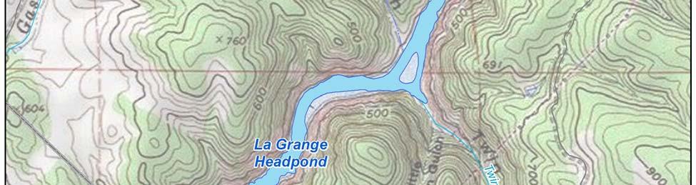
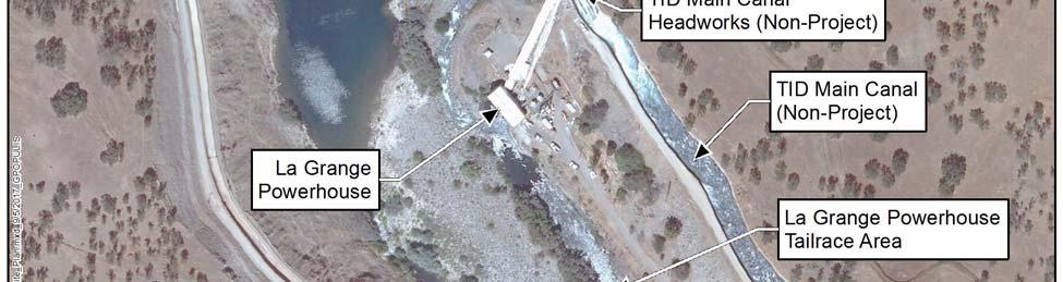
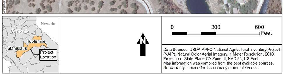
6 1.0 INTRODUCTION 1.1 Background The Turlock Irrigation District (TID) and Modesto Irrigation District (MID) (collectively, the Districts) jointly own the La Grange Diversion Dam (LGDD) located on the Tuolumne River in Stanislaus County, California (Figures and 1.1-2). LGDD is 131 feet high and is located at river mile (RM) 52.2 at the exit of a narrow canyon, the walls of which contain the headpond formed by the diversion dam. Under normal river flows, the headpond formed by the diversion dam extends for approximately two miles upstream. When not in spill mode, the water level upstream of the diversion dam is between elevation 294 feet and 296 feet approximately 90 percent of the time. Within this 2-foot range, the headpond storage is estimated to be less than 100 acre-feet of water. The drainage area of the Tuolumne River upstream of LGDD is approximately 1,550 square miles. Tuolumne River flows upstream of LGDD are regulated by four reservoirs: Hetch Hetchy, Lake Eleanor, Cherry Lake (also known as Lake Lloyd), and Don Pedro. The Don Pedro Hydroelectric Project (Federal Energy Regulatory Commission [the Commission or FERC] No. 2299) is owned jointly by the Districts, and the other three dams are owned by the City and County of San Francisco (CCSF) and operated by the San Francisco Public Utilities Commission. Inflow to the La Grange headpond is the sum of releases from the Don Pedro Project, located 2.3 miles upstream, and very minor contributions from two small intermittent drainageways downstream of Don Pedro Dam. LGDD was constructed from 1891 to 1893 displacing Wheaton Dam, which was built by other parties in the early 1870s. LGDD raised the level of the Tuolumne River to permit the diversion and delivery of water by gravity to irrigation systems owned by TID and MID. The Districts irrigation systems currently provide water to over 200,000 acres of prime Central Valley farmland and drinking water to the City of Modesto. Built in 1924, the La Grange hydroelectric plant is located approximately 0.2 miles downstream of LGDD on the east (left) bank of the Tuolumne River and is owned and operated by TID. The powerhouse has a capacity of 4.7 megawatts (MW). The La Grange Hydroelectric Project (Project; FERC No ) operates in run-of-river mode. The LGDD provides no flood control benefits, and there are no existing recreation facilities associated with the Project or the La Grange headpond. Fish Barrier Assessment 1-1 Updated Study Report


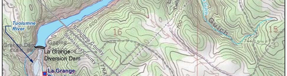
7 1.0 Introduction Figure La Grange Hydroelectric Project location map. Fish Barrier Assessment 1-2 Updated Study Report


8 1.0 Introduction Figure La Grange Hydroelectric Project site plan. Fish Barrier Assessment 1-3 Updated Study Report
9 1.0 Introduction 1.2 Licensing Process In 2014, the Districts commenced the pre-filing process for the licensing of the La Grange Project by filing a Pre-Application Document with FERC 1. On September 5, 2014, the Districts filed their Proposed Study Plan to assess Project effects on fish and aquatic resources, recreation, and cultural resources in support of their intent to license the Project. On January 5, 2015, in response to comments from licensing participants, the Districts filed their Revised Study Plan (RSP) containing three study plans: (1) Cultural Resources Study Plan; (2) Recreation Access and Safety Assessment Study Plan; and (3) Fish Passage Assessment Study Plan 2. On February 2, 2015, FERC issued the Study Plan Determination (SPD), approving or approving with modifications six studies (Table 1.2-1). Of those six studies, five had been proposed by the Districts in the RSP. The Districts note that although FERC s SPD identified the Fish Passage Barrier Assessment, Fish Passage Facilities Alternatives Assessment, and Fish Habitat and Stranding Assessment below La Grange Diversion Dam as three separate studies, all three assessments are elements of the larger Fish Passage Assessment as described in the RSP. The sixth study approved by FERC, Effects of the Project and Related Activities on the Losses of Marine-Derived Nutrients in the Tuolumne River, was requested by the National Marine Fisheries Service (NMFS) in its July 22, 2014 comment letter. Table Studies approved or approved with modifications in FERC s Study Plan Determination. No. Study Approved by FERC in SPD without Modifications Approved by FERC in SPD with Modifications 1 Recreation Access and Safety Assessment X 2 Cultural Resources Study X 3 Fish Passage Barrier Assessment X 1 4 Fish Passage Facilities Alternatives Assessment X 5 Fish Habitat and Stranding Assessment below La Grange Dam X 6 Effects of the Project and Related Activities on the Losses of Marine-Derived Nutrients in the Tuolumne River X 2 1 Page A-1 of Appendix A of FERC s SPD states that FERC approved with modifications the Fish Passage Barrier Assessment. However, the Districts found no modifications to this study plan in the SPD, and page B-7 of the SPD states no modifications to the study plan are recommended. 2 FERC directed the Districts to conduct the study plan as proposed by NMFS. In the SPD, FERC recommended that, as part of the Fish Passage Facilities Alternatives Assessment, the Districts evaluate the technical and biological feasibility of the movement of anadromous salmonids through La Grange and Don Pedro project reservoirs if the results from 1 On December 19, 2012, Commission staff issued an order finding that the La Grange Hydroelectric Project is required to be licensed under Section 23(b)(1) of the Federal Power Act. Turlock Irrigation District and Modesto Irrigation District, 141 FERC 62,211 (2012), aff d Turlock Irrigation District and Modesto Irrigation District, 144 FERC 61,051 (2013). On May 15, 2015, the U.S. Court of Appeals for the District of Columbia Circuit denied the Districts appeal and affirmed the Commission s finding that the La Grange Hydroelectric Project requires licensing. Turlock Irrigation District, et al., v. FERC, et al., No (D.C. Cir. May 15, 2015). 2 The Fish Passage Assessment Study Plan contained a number of individual, but related, study elements. Fish Barrier Assessment 1-4 Updated Study Report
10 1.0 Introduction Phase 1 of that study indicate that the most feasible concept for fish passage would involve fish passage through Don Pedro Reservoir or La Grange headpond. On September 16, 2016, the Districts filed the final study plan with FERC. On November 17, 2016, the Districts filed a letter with FERC after consulting with fish management agencies (i.e., NMFS and the California Department of Fish and Wildlife [CDFW]) regarding the availability of test fish and a determination that no fish would be available to support conducting this study in On January 12, 2017, the Districts filed a letter with FERC stating that with FERC s approval, they intend to conduct the study in 2018 if the results from the Fish Passage Facilities Alternatives Assessment indicate that upstream or downstream fish passage at La Grange and Don Pedro projects would require anadromous fish transit through one or both reservoirs. In addition to the six studies noted in Table 1.2-1, the SPD required the Districts to develop a plan to monitor anadromous fish movement in the vicinity of the Project s powerhouse draft tubes to determine the potential for injury or mortality from contact with the turbine runners. The Districts filed the Investigation of Fish Attraction to La Grange Powerhouse Draft Tubes study plan with FERC on June 11, 2015, and on August 12, 2015, FERC approved the study plan as filed. On February 2, 2016, the Districts filed the Initial Study Report (ISR) for the La Grange Hydroelectric Project. The Districts held an ISR meeting on February 25, 2016, and on March 3, 2016, filed a meeting summary. Comments on the meeting summary and requests for new studies and study modifications were to be submitted to FERC by Monday, April 4, One new study request was submitted; NMFS requested a new study entitled Effects of La Grange Hydroelectric Project Under Changing Climate (Climate Change Study). On May 2, 2016, the Districts filed with FERC a response to comments received from licensing participants and proposed modifications to the Fish Passage Facilities Alternatives Assessment and the La Grange Project Fish Barrier Assessment, and a revised pre-filing schedule. On May 27, 2016, FERC filed a determination on requests for study modifications and new study. The May 27, 2016 determination approved the Districts proposed modifications and did not approve the NMFS Climate Change Study, and accepted the Districts revised pre-filing schedule. On February 1, 2017, the Districts filed the Updated Study Report (USR) for the La Grange Hydroelectric Project. The Districts held a USR meeting on February 16, 2017, and on March 3, 2017, filed a meeting summary. Comments on the meeting summary and requests for new studies and study modifications were to be submitted to FERC by Monday, April 3, Comments on the USR were received from the Central Sierra Environmental Resource Center on February 27, 2017, from NMFS on April 3, 2017, and from CDFW on April 13, On May 2, 2017, the Districts filed with FERC a response to comments received from licensing participants. On April 24, 2017, the Districts filed the Draft License Application for the La Grange Hydroelectric Project. Comments on the Draft License Application were received from NMFS on May 12, 2017, from FERC on July 18, 2017, and from CDFW on August 18, The Districts response to these comments is included in the La Grange Hydroelectric Project Final License Application (FLA). The FLA was filed with FERC on October 11, 2017, in accordance with the Districts Request for Extension of Time granted by FERC on September 1, Fish Barrier Assessment 1-5 Updated Study Report
11 1.0 Introduction This study report describes the objectives, methods, and results of the La Grange Project Fish Barrier Assessment (herein referred to as the Fish Barrier Assessment), which is one component of the Fish Passage Facilities Assessment as implemented by the Districts in accordance with the SPD. Documents relating to the Project licensing are publicly available on the Districts licensing website at Study Plan FERC s Scoping Document 2 (SD2) issued on September 5, 2014 identified potential effects of Project operations on the upstream migration of anadromous fish. FERC s SPD approved without modification the Districts Fish Barrier Assessment as proposed in the RSP. In comments on the Pre-Application Document, NMFS, CDFW, and the Conservation Groups state that LGDD and the La Grange powerhouse are barriers to upstream anadromous fish migration, and a study to evaluate whether the dam and powerhouse are barriers is not needed. However, FERC staff approved the study stating that the information collected in this study would help define the nature and degree to which the dam and powerhouse are barriers or impediments to the upstream migration of anadromous salmonids. No comments were filed in response to the Fish Barrier Assessment as proposed in the RSP. Fish Barrier Assessment 1-6 Updated Study Report
12 2.0 STUDY GOALS AND OBJECTIVES The purpose of the Fish Barrier Assessment is to evaluate the extent to which the LGDD and the La Grange powerhouse act as as barriers to the upstream migration and spawning of adult fallrun Chinook salmon (Oncorhynchus tshawytscha) and, if they occur, steelhead (O. mykiss). This includes documenting the proportion of the fall-run Chinook salmon population that may migrate upstream to these facilities and evaluating potential impacts to the spawning of these fish. Objectives of this study are to: determine the number of fall-run Chinook salmon and steelhead migrating upstream to LGDD and the La Grange powerhouse during the 2015/2016 and 2016/2017 migration seasons; compare the number of fall-run Chinook salmon and steelhead migrating upstream to the LGDD and the La Grange powerhouse to total escapement during the 2015/2016 and 2016/2017 migration seasons; document carcass condition (egg retention) to evaluate pre-spawn mortality rates of fall-run Chinook salmon and steelhead migrating upstream to LGDD and the La Grange powerhouse, which do not move back downstream to spawn; and implement formal documentation of incidental fish observations in the vicinity of LGDD, La Grange powerhouse tailrace, and TID sluice gate channel. Note that this objective is being addressed as part of the Fish Presence and Stranding Assessment (TID/MID 2017a). Fish Barrier Assessment 2-1 Updated Study Report
13 3.0 STUDY AREA The study area includes the Tuolumne River from LGDD (RM 52.2) downstream to the mainstem channel fish counting weir, and the La Grange powerhouse tailrace channel downstream to the tailrace channel fish counting weir (Figure 3.0-1). Daily boat surveys were conducted in both channels from LGDD to 0.3 miles downstream of the weir locations to document potential fish stacking or pre-spawn mortality. This study also includes data collected from monitoring conducted at a fish counting weir operated by the Districts at RM Fish Barrier Assessment 3-1 Updated Study Report

14 3.0 Study Area Figure Location of main channel weir and tailrace channel weir. Fish Barrier Assessment September Updated Study Report La Grange Hydroelectric Project, FERC No
15 4.0 METHODOLOGY 4.1 Weir Configurations Two fish counting weirs were installed in the Tuolumne River near the La Grange facilities. One weir segment was placed downstream of the large pool below LGDD in the Tuolumne River main channel, and the second segment was placed just below the La Grange powerhouse in the tailrace channel (Figure 3.0-1). Each weir structure consisted of rigid weir panels that directed fish passage through a passing chute that was continuously monitored by a video system. Each weir panel was constructed of steel angle and horizontal pipe with 1 1/8-inch spacing and secured in-channel diagonal to the river flow. The passing chute of the main channel weir (Figure 4.1-1) consisted of a 3-foot-wide by 4-footlong white high-density polyethylene floor that was secured to the substrate. An overhead camera and an underwater side-view camera were positioned to view the entire passing chute. The tailrace weir (Figure 4.1-2) consisted of a 6-foot wide by 6-foot long high-density polyethylene passing chute equipped with an overhead camera and two underwater side-view cameras. Each passing chute was equipped with an infrared lighting system for 24-hour monitoring. Similar video systems have been operated by CDFW to monitor the passage of Chinook salmon and steelhead on Sacramento River tributaries (Killiam and Johnson 2008). The overhead cameras at each weir provided full coverage of the passing chute area and were used to detect fish passage events. Underwater cameras were used to assist with species identification for each passage event. A multi-camera video surveillance application (SecuritySpy) was used to route footage to computers for storage. Hourly video files from each camera were saved to external hard drives and downloaded daily for data back-up. Additionally, motion detection settings in the video surveillance application were used to create five-second clips of all potential passage events. 4.2 Weir Operations The weirs were cleaned, weir performance was documented, and video footage was downloaded daily (generally between 8:00 am and 11:00 am each day). Environmental data collected during each weir check included dissolved oxygen (mg/l), stream stage (feet), turbidity (nephelometric turbidity units [NTU]), and water velocity (feet per second [ft/sec]) at the opening of the fish passage chute. Provisional daily average flow data for the Tuolumne River at La Grange was obtained from U.S. Geological Survey (USGS) Gage ( Hourly water temperature data were obtained from Hobo Pro v2 water temperature data loggers (Onset Computer Corporation) maintained at each weir site. Visual assessments were also conducted daily to ensure that fish were not stacking on either side of the weir, as required by the CDFW scientific collection permit amendment. Boat surveys were conducted in both channels from LGDD to 0.3 miles downstream of the weir locations. Any spawning activity, live fall-run Chinook salmon (Oncorhynchus tshawytscha) or Oncorhynchus mykiss (O. mykiss), or carcasses observed upstream or downstream of the weir were recorded. Daily stacking counts were reported to CDFW three times per week ( stacking was defined as 30 or more individuals on either side of the weir). Fish Barrier Assessment 4-1 Updated Study Report


16 4.0 Methodology Figure Upstream view of main channel weir and passing chute. Figure Overhead view of tailrace channel weir and passing chute. Fish Barrier Assessment 4-2 Updated Study Report
17 4.0 Methodology 4.3 Video Review A fisheries biologist or technician with prior video review training and experience reviewed digital video footage to determine passage events. Video review was limited to a group of five individuals to ensure consistency through the review period. To expedite video review, a motion detection system was initially used in 2015/2016 to capture five-second motion detection clips from the overhead camera to determine fish presence, estimated length, and direction of passage. However, a high number of missed passages and/or false detections were identified during review of the video files. With the motion detection system found to be ineffective, all overhead video files were reviewed at 10x speed to identify fish passage events. Passage date, time, direction of passage, species, and estimated fish size were recorded for each passage event. Underwater camera views were also used to aid in species identification, sex determination, and presence of an adipose fin. The certainty of each fish observation was recorded as high, medium, or low. A high certainty rating signified complete confidence in determining species and the presence or absence of an adipose fin; medium suggested confidence in determining species but sex and/or presence of an adipose fin was unknown; and low suggested uncertainty in determining species. Video review quality assurance procedures consisted of an independent review of a subsample of video data by a different fisheries biologist or technician than had originally reviewed the video. Data selected for a second review included species identified as unknown, passages with a low observational certainty, and all passages initially identified as O. mykiss. Raw data were summarized to determine daily upstream and downstream weir counts and the total numbers of individual Chinook moving through the weir (i.e., generating passage events) Note that the number of passage events is not equal to the numbers of individual fish since a single fish can produce multiple passage events. When possible, individual fish were identified based on estimated fish length, sex, and general morphological characteristics. The total number of individual Chinook identified at the tailrace and main channel weirs was divided by total escapement determined at the lower weir (at RM 24.5) to estimate the proportion of the fall-run Chinook escapement that may migrate upstream to the La Grange facilities. 4.4 Statistical Analysis Statistical Inference for the 2016/2017 Monitoring Year The two monitoring years were quite different with respect to environmental conditions (higher discharges in 2016/2017) and overall numbers of Chinook salmon present in the Tuolumne River. Greater numbers of fish and associated passage events prevented identification of unique individuals in 2016/2017. Therefore, statistical inference was used to estimate the total number of individuals present in the vicinity of the La Grange facilities in 2016/2017 based on the number of uniquely identified fish and passage events recorded for the 2015/2016 season. A principle assumption with this approach was that the 2015/2016 data was representative of the 2016/2017 data with respect to number of passages per individual and sex ratios (i.e., it assumes that descriptive statistics from 2015/2016 accurately describe 2016/2017 as well). Thus it was necessary to start by comparing the distribution of total unidirectional passage events (upstream Fish Barrier Assessment 4-3 Updated Study Report
18 4.0 Methodology or downstream weir counts) between monitoring years (statistically, if the two distributions were different between years than the principle assumption was no longer valid). In addition, because sex could not always be determined for a passage event (this occurred in both 2015/2016 and 2016/2017), the number of passage events for which sex could be determined versus events where sex was undetermined was also compared. This second comparison was to evaluate if environmental factors influenced the ability to identify sex of Chinook. If the ratio of identified to unidentified sex was different between years, then passage counts for those years might not be directly comparable and the principle assumption would no longer be valid Inference Method #1: All 2015/2016 Chinook Combined After comparing the distribution of passage events between years, the next step was to characterize the number of passages per uniquely identified individual observed in 2015/2016. A total of 105 individual Chinook accounted for 2,329 passage events at the tailrace weir and 12 Chinook accounted for 935 passage events at the main channel weir. To estimate the number of individual Chinook present in 2016/2017 at both weirs, the total number of passage events in 2016/2017 was expanded by dividing the mean and median number of passages per individual at each weir in 2015/ Inference Method #2: 2015/2016 Chinook Grouped by Sex Estimating the total number of individuals in 2016/2017 based on summary statistics from all 2015/2016 individuals combined assumes that males and females have a similar propensity of movement (inference method #1). However, if males and females have different rates of movement, then sex-specific summary statistics would be needed to estimate the total number of individuals from passage events. A Student's t-test was used to test if 2015/2016 males and females exhibited differences in number of passages. The number of passages per individual was transformed to meet normality assumptions. Estimates of the number of male and female Chinook present in 2016/2017 at each weir were derived in the same manner as for all individuals combined, except that the total number of passage events was first apportioned into male or female events. Using the 2016/2017 passage events for which sex could be assigned, the proportions of male and female passage events were used to assign sex to passage events where sex was undetermined. For example, if females made up 25 percent of the passages that could be assigned a sex, then it was assumed that 25 percent of the passages of unknown sex were female. The numbers of male and female 2016/2017 passages were then expanded by dividing their respective mean and median number of passages per individual calculated from 2015/2016 males and females. 4.5 Lower Tuolumne River Weir The Districts operate a fish counting weir at RM 24.5, which is located downstream of the fallrun Chinook salmon spawning reach. Monitoring objectives at this weir location include determining total escapement of fall-run Chinook salmon and O. mykiss to the Tuolumne River through direct counts. This weir has been operated annually since 2009 (Becker et al. 2016; Sonke 2017), and monitoring occurred continuously during the period that the La Grange weirs were operated. Fish Barrier Assessment 4-4 Updated Study Report
19 4.0 Methodology 4.6 Pre-spawn Mortality Evaluation Salmon encountering barriers to migration may experience pre-spawn mortality. During carcass surveys conducted to estimate salmon escapement, CDFW examines female Chinook salmon carcasses for egg retention to estimate pre-spawn mortality. Assessments of pre-spawn mortality have been conducted in several Central Valley streams in some years; however, these assessments have been intermittent and inconsistent due to a lack of available funding and staff. CDFW has conducted pre-spawn mortality evaluations in 1993, 1999, 2008, 2013, and and documented low levels of pre-spawn or partial-spawn mortality of fall-run Chinook in the Tuolumne River (CDFW 2014, Gretchen Murphey, CDFW pers. comm.). Of the years evaluated, the maximum annual occurrence of pre-spawn or partial-spawn mortality documented was five individuals (2013). To evaluate the effect of LGDD and the La Grange powerhouse on the spawning success of upstream migrants and thereby, the productivity of the Tuolumne River population, daily surveys above the counting weir were conducted to assess the presence/absence of live Chinook salmon, spawning activity, or carcasses. Chinook carcasses were visually assessed for egg retention, and all fish carcasses observed were collected, frozen, and delivered to CDFW LA Grange staff. CDFW also conducted pre-spawn mortality evaluations throughout the spawning reach as part of their annual fall-run Chinook salmon escapement surveys (Gretchen Murphey, CDFW pers. comm.). Fish Barrier Assessment 4-5 Updated Study Report
20 5.0 STUDY RESULTS This section summarizes all data collected during the 2015/2016 and 2016/2017 monitoring seasons. 5.1 Weir Operations /2016 Monitoring Season During the 2015/2016 monitoring season, both weirs operated almost continuously between September 23, 2015 and April 15, Two high-debris flow events on October 17 and October 28 washed out a portion of the tailrace channel rigid weir structure. Sections of the rigid weir were temporarily removed and reinstalled resulting in the system being inoperable for 40.8 hours and 27.0 hours on October 17 and October 28, respectively. On eight other occasions the tailrace weir video monitoring system was inactive (i.e., video was not recorded due to camera or computer malfunctions), with outage times ranging from 3.3 hours to 30.7 hours (mean 14.1 hours). Overall the tailrace video system recorded video footage for 97.3 percent of the monitoring period. The main channel weir video system was inactive on 22 occasions, with outage times ranging from two hours to 35.6 hours (mean 15.7 hours) (Table 5.1-1). System outages at the main channel weir were associated with extended periods with minimal sunlight resulting in the computer turning off due to low battery voltage. Overall the main channel video system recorded video footage for 91.2 percent of the monitoring period. During the monitoring period, average daily flow recorded at La Grange ranged from 91 to 175 cfs (Figure 5.1-1). River flow through the main channel weir was provided by the MID hillside discharge and was estimated to be 5 to 10 cfs throughout the study period (TID/MID 2017b). Instantaneous water velocity recorded in the main channel fish counting weir passage chute ranged from 0.3 to 2.4 feet per second (ft/sec) (mean 0.9 ft/sec). The remainder of the flow recorded at La Grange facilities originated from the powerhouse and/or TID sluice gate channel and flowed through the tailrace channel fish counting weir. 3 Instantaneous water velocity recorded at the tailrace channel fish counting weir passage chute ranged from 0.6 ft/sec to 4.7 ft/sec (mean 2.6 ft/sec). Average daily water temperatures recorded at each weir site ranged from 50.1 F to 64.2 F (10.1 C to 17.9 C) in the tailrace channel and 48.7 F to 67.4 F (9.3 C to 19.7 C) in the main channel (Figure 5.1-1). Instantaneous turbidity ranged from 0.69 NTU to NTU (mean 2.82 NTU) in the tailrace channel and from 0.54 NTU to NTU (mean 2.44 NTU) in the main channel. Instantaneous dissolved oxygen ranged from 4.03 mg/l to mg/l (mean 9.34 mg/l) in the tailrace channel and from 8.96 mg/l to mg/l (mean mg/l) in the main channel. 3 During the monitoring season TID maintained an 18-inch pipe in an open position that continuously delivers flow of approximately 5 to 10 cfs to the channel downstream of the sluice gates. This water flows into the tailrace just upstream of the powerhouse. Fish Barrier Assessment 5-1 Updated Study Report
21 5.0 Study Results Table Summary of video recording outage periods during the 2015/2016 monitoring season. Weir Date Outage Time Outage Time Outage Date Duration Began Ended (hours) Tailrace 10/17/ :12 10/19/15 16: Tailrace 10/28/ :00 10/29/15 16: Main Channel 11/24/15 3:13 11/24/15 8: Main Channel 11/24/15 23:23 11/25/15 8: Main Channel 11/25/15 8:53 11/26/15 9: Main Channel 12/2/15 21:48 12/4/15 9: Main Channel 12/5/15 7:05 12/5/15 9: Main Channel 12/5/15 22:18 12/6/15 11: Main Channel 12/11/15 23:42 12/12/15 9: Main Channel 12/13/15 6:52 12/13/15 9: Main Channel 12/13/15 12:23 12/14/15 10: Main Channel 12/19/15 9:33 12/20/15 10: Main Channel 12/20/15 18:49 12/21/15 11: Main Channel 12/21/15 17:24 12/22/15 9: Main Channel 12/22/15 20:39 12/23/15 10: Main Channel 12/24/15 6:13 12/24/15 10: Main Channel 12/24/15 23:26 12/25/15 9: Tailrace 1/3/16 19:51 1/4/16 11: Main Channel 1/4/16 20:13 1/5/16 11: Main Channel 1/5/16 15:32 1/6/16 9: Main Channel 1/17/16 11:19 1/18/16 14: Tailrace 1/19/16 5:00 1/19/16 11: Tailrace 1/24/16 6:00 1/24/16 9: Tailrace 1/31/16 6:00 2/1/16 12: Main Channel 2/2/16 10:19 2/3/16 10: Main Channel 2/6/16 12:49 2/7/16 9: Tailrace 2/27/16 3:47 2/27/16 10: Tailrace 2/27/16 11:29 2/28/16 10: Main Channel 3/11/16 9:07 3/12/16 11: Tailrace 3/20/16 13:00 3/21/16 9: Tailrace 4/10/16 5:00 4/10/16 10: Main Channel 4/14/16 8:32 4/14/16 10: A portion of the weir was temporarily removed due to high-debris flow events. Fish Barrier Assessment 5-2 Updated Study Report
22 5.0 Study Results Flow (cfs) Temperature ( F) LGN Flow Tailrace Main Channel Figure Mean daily flow (cfs) at the USGS gage ( ) and mean daily water temperatures at the tailrace channel weir and the main channel weir during the 2015/2016 monitoring season /2017 Monitoring Season During the 2016/2017 monitoring season, both weirs were installed on September 15, After a brief testing period, the video monitoring system was fully functional on September 20, Monitoring was suspended and all equipment removed from the river on January 2, 2017 due to the onset of flood control releases from Don Pedro Reservoir, with flow recorded at La Grange ranging from 1,770 cfs to 13,900 cfs through April 30, The tailrace weir was temporarily removed from October 12 through November 4 (554.7 hours), due to flow operations that exceeded the operational capability of the weir structure. On seven other occasions the tailrace weir video monitoring system was inactive (i.e., video was not recorded due to camera or computer malfunctions), with outage times ranging from 10.9 hours to 18.4 hours (mean 13.7 hours). Overall, the tailrace video system recorded video footage for 74.1 percent of the monitoring period. The main channel weir video system was inactive on 18 occasions, with outage times ranging from 1.3 hours to hours (mean 26.1 hours) (Table 5.1-2). System outages at the main channel weir between October 14 and November 1 were associated with extended periods when access to the site was limited due to high flows. System outages during the remainder of the monitoring period were often associated with minimal sunlight resulting in the computer turning off due to low battery voltage. Overall, the main channel video system recorded video footage for 81.2 percent of the monitoring period. Fish Barrier Assessment 5-3 Updated Study Report
23 5.0 Study Results Table Summary of video recording outage periods during the 2016/2017 monitoring season. Weir Date Outage Time Outage Time Outage Date Duration Began Ended (hours) Tailrace 9/20/ :32 9/21/16 6: Tailrace 9/21/16 19:32 9/22/16 6: Main Channel 9/24/ :28 9/25/16 8: Main Channel 9/25/16 14:31 9/26/16 9: Tailrace 9/26/16 18:59 9/27/16 11: Tailrace 9/27/16 17:23 9/28/16 9: Main Channel 9/27/16 14:09 9/28/16 9: Tailrace 9/28/ :12 9/29/16 6: Main Channel 9/28/16 14:12 9/29/16 9: Tailrace 9/29/ :12 9/30/16 6: Main Channel 9/29/16 15:19 9/30/16 9: Tailrace 10/12/16 2 8:44 11/4/16 11: Main Channel 10/14/16 3 4:48 10/20/16 11: Main Channel 10/24/16 3 5:57 10/24/16 9: Main Channel 10/24/ :06 11/1/16 8: Main Channel 11/2/16 3 4:49 11/2/16 8: Main Channel 11/3/16 2 5:48 11/3/16 8: Main Channel 11/4/16 6:17 11/4/16 9: Main Channel 11/5/16 5:30 11/5/16 9: Main Channel 11/6/16 4:43 11/6/16 9: Main Channel 11/6/16 20:38 11/7/16 8: Main Channel 11/8/16 2:36 11/8/16 8: Main Channel 11/9/16 3:40 11/9/16 8: Main Channel 11/10/16 6:08 11/10/16 8: Main Channel 11/11/16 6:43 11/11/16 8: Tailrace 11/20/16 9:38 11/21/16 4: No night video due to camera malfunction. 2 The tailrace weir was temporarily removed due to flow operations that exceeded the operational capability of the weir structure. 3 Access was limited to the main channel weir due to high flows in the tailrace and sluicegate channels. During the reporting period, average daily flow recorded at La Grange ranged from 83 to 1,150 cfs (Figure 5.1-2). Instantaneous water velocity recorded in the main channel fish counting weir passage chute ranged from 0.8 to 2.9 feet per second (ft/sec) (mean 1.8 ft/sec). Instantaneous water velocity recorded at the tailrace channel fish counting weir passage chute ranged from 1.2 to 6.5 ft/sec (mean 2.3 ft/sec). Average daily water temperatures recorded at each weir site ranged from 52.2 F to 53.6 F in the tailrace channel and 52.5 F to 56.2 F in the main channel (Figure 5.1-2) through November 15, Water temperature data are only available through November 15, 2016, as data loggers have not been retrieved due to flood control releases. Instantaneous turbidity ranged from 0.38 to 6.39 NTU (mean 1.20 NTU) in the tailrace channel and from 0.59 to 3.30 NTU (mean 1.28 NTU) in the main channel. Instantaneous dissolved oxygen ranged from 7.06 to mg/l (mean 8.45 mg/l) in the tailrace channel and from to mg/l (mean mg/l) in the main channel. Fish Barrier Assessment 5-4 Updated Study Report
24 5.0 Study Results Flow (cfs) Temperature ( F) /15/16 9/30/16 10/15/16 10/30/16 11/14/16 11/29/16 12/14/16 12/29/16 LGN Flow Tailrace Main Channel Figure Mean daily flow (cfs) at the USGS gage (LGN) and daily mean water temperatures at the tailrace channel weir and the main channel weir during the 2016/2017 monitoring season. 5.2 Fish Passage at Counting Weirs Chinook Salmon Near La Grange Facilities: 2015/2016 Monitoring Season Based on data collected between September 23, 2015 and April 14, 2016, a total of 3,264 fall-run Chinook salmon passage events (1,617 upstream, 1,647 downstream) were detected at the tailrace and main channel weirs (Attachment A). The first Chinook salmon upstream passage event was observed September 23, 2015, and the last Chinook salmon passage event was observed February 15, The majority of passage events (89.7 percent) occurred during November and December accounting for 48.0 percent and 41.7 percent of Chinook salmon passages, respectively (Figure 5.2-1). Individual fish were identified based on estimated fish length, sex, and general morphological characteristics. This classification resulted in a total of 105 individual Chinook salmon accounting for the 2,329 passage events at the tailrace channel weir, and a total of 12 Chinook salmon accounting for the 935 passages at the main channel weir. Although sex was assigned for the majority of passage events, it was not always assigned if the video reviewer was uncertain of the individual's sex. For 2015/2016, 69.7 percent of passage events were assigned a sex. Of the passages that could be assigned a sex, the ratio of female to male events was This resulted in 35 females and 82 males, with 28.2 percent (n=33) of the fish having a clipped adipose fin Fish Barrier Assessment 5-5 Updated Study Report
25 5.0 Study Results (ad-clipped) indicating hatchery origin 4. Given the close proximity between the main channel and tailrace monitoring locations, it is likely that some individuals may have been detected at both weirs. Evaluation of these movements between the two channels was not evaluated, as it was beyond the scope of this study. Individual Chinook salmon often made multiple, consecutive upstream and downstream passages. The mean number of upstream/downstream passage events for individual salmon at the tailrace weir was 10.8 (range: 1 to 54 passages), and at the main channel weir was 38.8 (range: 1 to 111 passages). At the tailrace weir, the median time from initial passage event through final passage event was hours (4.23 days), and ranged from 0.37 hours to hours (34.33 days). At the main channel weir, the median time from initial passage event through final passage event was hours (6.40 days), and ranged from 4.83 hours to hours (20.47 days). The maximum time observed between initial passage and final passage was a male Chinook salmon that made multiple upstream and downstream passages in the tailrace channel over a 34 day period between September 23, 2015 and October 27, Female salmon were not observed at the weirs until October 21, and within six days of arrival of the first female salmon, this male was no longer detected. It is likely that this fish was holding in the area below La Grange powerhouse waiting for the arrival of a mate. As this fish was observed before the Tuolumne River weir (RM 24.5) was installed on September 28, 2015, it is unknown when this fish moved into the spawning reach. Figure Daily Chinook passage events at the tailrace and main channel weirs during the 2015/2016 monitoring season. 4 The Central Valley Constant Fractional Marking Program (CFM) was initiated in 2007 to estimate the relative contribution of hatchery production. Beginning with Brood year 2006 fall-run Chinook, the program has marked a minimum of 25 percent of releases from the Central Valley hatcheries each year (Buttars 2013). Fish Barrier Assessment 5-6 Updated Study Report

26 5.0 Study Results Chinook Salmon Near La Grange Facilities: 2016/2017 Monitoring Season High flows prevented weir operation from October 12, 2016 to November 4, 2016, and sampling was suspended for the season on January 2, Despite having a shorter sample season, daily passages were much greater during the 2016/2017 monitoring season than during the 2015/2016 monitoring season. Based on data collected between September 15, 2016 and January 1, 2017, a total of 11,239 fallrun Chinook salmon passage events (5,485 upstream, 5,754 downstream) were detected at the tailrace weir and 10,544 Chinook passage events (5,248 upstream, 5,296 downstream) at the main channel weir (Figure 5.2-2; Attachment B, Tables B-1 and B-2, available upon request). The first Chinook salmon passage event was October 8, 2016, and Chinook salmon were observed through January 1, Figure Daily Chinook passage events at the tailrace and main channel weirs during the 2016/2017 monitoring season. In 2016/2017, 74.8 percent of passage events at the tailrace weir were assigned a sex. Of those passage events, the ratio of female to male passage events was 0.19, roughly similar to the one female for every five male passages that was observed in 2015/2016. The high number of passage events at both weir sites prevented the accurate identification of unique individuals based on video review. Therefore statistical inference as described in Section above was used to estimate the total number of individuals present. Fish Barrier Assessment 5-7 Updated Study Report
27 5.0 Study Results Inferring Number of Chinook Salmon in 2016/ Passages by Unique Individuals in 2015/2016 A total of 105 uniquely identified individuals were observed in 2015/2016 at the tailrace weir and were responsible for 2,329 unidirectional passage events. Of these fish, 74 (70 percent) were male and 31 (30 percent) were female. At the main channel weir, 12 individuals (four females and eight males) were responsible for 935 passage events. Because unique individuals could be identified and monitored in 2015/2016, it was possible to use the distribution of passage events per individual to help infer the number of unique individuals present at each weir in 2016/2017. The distribution was highly right skewed (Figure 5.2-3), meaning that even though the mean number of passage events per individual in was 21.8 (95 percent confidence interval = ), most individuals had 14.0 ( ) or fewer passage events. Therefore the median value provided a better representation of the number of passages per individual than the mean, thus results presented were based on median values. The mean number of unidirectional passages per individual at the main channel weir was 77.7 ( ) and the median was 65.5 ( ). The number of identified individuals at the main channel weir, some of which were also responsible for passage events at the tailrace weir, was too small to compare the distributions between weirs or compare number of passages between males and females. Although results are presented for both weirs in the text, figures present the results of the tailrace analysis. Figure Number of passages per male and female Chinook salmon near the La Grange facilities in 2015/2016. The solid black line represents the median value of males and females combined. Dashed lines are female (red) and male (blue) medians, respectively. Fish Barrier Assessment 5-8 Updated Study Report
28 5.0 Study Results Inference Method #1: All Individuals Combined Based on a total of 11,239 passages at the tailrace weir for 2016/2017 and using the median number of passages per fish from 2015/2016, the total number of unique individuals present in 2016/2017 was approximately 802 (562 1, percent confidence interval [CI]) fish (Table 5.2-1). Assuming that the sex ratio was consistent between years, this would translate to roughly 241 females and 561 males. At the main channel weir, a total of 10,276 passages in 2016/2017 would equate to approximately 160 (95 734) individuals using the median number of passages per fish observed in 2015/ Inference Method #2: Individuals Grouped by Sex The above estimation method makes the assumption that males and females behave similarly with respect to how much they move and that the number of passages between males and females is similar. However, males and females from 2015/2016 did show a significant difference in number of passages (Figure 5.2-4). Males at the tailrace weir had a significantly greater number of passages than females ( 0.006) based on a Student's t-test. The number of passage events was also more variable for males relative to females. The number of males and females at the main channel weir was too small for assessing sex specific differences. Figure Number of passage events at the tailrace weir for Chinook salmon near the La Grange facilities during 2015/2016 monitoring Since it appeared that sex could influence the number of passages per individual at the tailrace weir, an alternative method to estimating the number of individuals in 2016/2017 was to use different median number of passages at the tailrace weir for males and females. The median Fish Barrier Assessment 5-9 Updated Study Report
29 5.0 Study Results number of passages for females was eight ( percent CI) and the median number of passages for males was 19 ( percent CI) (Table 5.2-1). At the main channel weir, the median number of passages was 27 (0 218) for females and 81 (2 118) for males. Table Weir Tailrace Main Channel Sex-specific values used to estimate the number of unique Chinook at the tailrace and main channel weirs in 2016/2017 from the number of passages. Inference Method 1 Sex Male & Female Proportion of Passages Number of Passages Median Estimate 95% CI , ,124 2 Female , Male , Male & Female , Female , Infinity 2 Male , ,375 Because the percentage of sex-assigned passages at the tailrace weir was similar in 2015/2016 to 2016/2017 (69.7 percent and 74.8 percent, respectively), and the ratio of female to male passages of known sex was also similar (0.21 and 0.19, respectively), the total number of passages in 2016/2017 (11,239) were apportioned into males and females based on the proportion of each sex for the passage events where sex could be assigned (Table 5.2-1). Applying the sex-specific median number of passages to the total number of passages provided an estimate of approximately 225 ( percent CI) females and 497 ( percent CI) males for a total of 722 individual fall-run Chinook ( percent CI) present at the tailrace weir. Sex specific estimates for the main channel weir were 130 females (16 infinity 95 percent CI) and 83 males ( percent CI) for a total of approximately 213 individuals. The low number of individuals at the main channel weir in 2015/2016 resulted wider median confidence intervals that led to wider 95 percent confidence intervals of the estimates O. mykiss Near La Grange Facilities: 2015/2016 Monitoring Season A total of 270 O. mykiss passage events (140 upstream, 130 downstream) were detected at the tailrace weir during the 2015/2016 monitoring period. No O. mykiss were detected at the main channel weir. Estimated lengths of O. mykiss observed ranged from 10 cm to 60 cm. Adult-sized O. mykiss (>30 cm) accounted for 141 of these passage events (68 upstream, 73 downstream) (Figure 5.2-5, Attachment A). Adult O. mykiss were first observed on October 6, 2015, and last observed on March 29, 2016 (Figure 5.2-6). The majority of adult O. mykiss detections occurred during the November through January period, accounting for 83.5 percent of the passage events. Unlike Chinook salmon, it was not possible to identify the total number of individual O. mykiss (<40 cm) as there was much less variability in fish length, sex, and general morphological characteristics. Fish Barrier Assessment 5-10 Updated Study Report

 passage events at the tailrace channel weir during the 2015/2016 monitoring season.")
30 5.0 Study Results Count Estimated Length (cm) Upstream Downstream Figure Length histogram of O. mykiss passage events at the tailrace channel weir during the 2015/2016 monitoring season. Daily Adult O. mykiss (>30 cm) Passage Events /1/15 11/1/15 12/1/15 1/1/16 2/1/16 3/1/16 4/1/16 Upstream Downstream Figure Daily adult O. mykiss (>30 cm) passage events at the tailrace channel weir during the 2015/2016 monitoring season. Fish Barrier Assessment 5-11 Updated Study Report
31 5.0 Study Results Large O. mykiss (>40 cm) accounted for 81 passage events (35 upstream, 46 downstream) during the 2015/2016 monitoring season. Passages of large O. mykiss were reviewed to identify individuals based on time of subsequent passages, estimated length, and general morphological characteristics. It was determined that 11 individuals accounted for 74.1 percent of the large O. mykiss passage events. The remaining passages could not be identified as individuals due to poor image quality (often associated with low light conditions). Two observations of ad-clipped O. mykiss were made on February 19 and February 24. Based on estimated length (~50 cm) and general morphological characteristics, these two observations were likely of a single fish. The absence of an adipose fin represents a hatchery-origin fish O. mykiss Near La Grange Facilities: 2016/2017 Monitoring Season A total of 919 O. mykiss passage events (437 upstream, 482 downstream) were detected at the tailrace weir during the 2016/2017 monitoring period. Estimated lengths of O. mykiss observed ranged from 10 cm to 50 cm (Figure 5.2-7). Adult-sized O. mykiss (>30 cm) accounted for 125 of these passage events (46 upstream, 79 downstream) (Figure 5.2-8, Attachment B). The first adult O. mykiss detection occurred on October 1, 2016, and the last passage event occurred on December 31, Sixty-two percent (n=78) of the adult O. mykiss passage events occurred in December. Unlike Chinook salmon, it was not possible to identify the total number of individual O. mykiss (<40 cm) as there was much less variability in fish length, sex, and general morphological characteristics. Large O. mykiss (>40 cm) accounted for 51 passage events (19 upstream, 32 downstream) during the 2016/2017 monitoring season. Passages of large O. mykiss were reviewed to identify individuals based on time of subsequent passages, estimated length, and general morphological characteristics. It was determined that five individuals accounted for 60.8 percent of the large O. mykiss passage events. The remaining passages could not be identified as individuals due to poor image quality (often associated with low light conditions). Eight passage events (four upstream, four downstream) of ad-clipped O. mykiss were observed between December 24 and December 31. Based on estimated length (40-50 cm) and general morphological characteristics, these observations were likely of a single fish. The absence of an adipose fin represents a hatchery-origin fish. A total of 831 O. mykiss passage events (344 upstream, 487 downstream) were detected at the main channel weir. Estimated lengths of O. mykiss observed ranged from 10 cm to 30 cm. Passage at the main channel weir was dominated by juvenile sized fish, with a single adult sized O. mykiss (30 cm) detected moving upstream, and subsequently downstream, on December 14, Fish Barrier Assessment 5-12 Updated Study Report
")


 passage events at the tailrace channel")
32 5.0 Study Results Count Estimated Length (cm) Upstream Downstream Figure Length histogram of O. mykiss passage events at the tailrace channel weir during the 2016/2017 monitoring season. Figure Daily adult O. mykiss (>30 cm) passage events at the tailrace channel weir during the 2016/2017 monitoring season. Fish Barrier Assessment 5-13 Updated Study Report
Susitna-Watana Hydroelectric Project (FERC No ) Salmon Escapement Study Study Plan Section 9.7
 Salmon Escapement Study Study Plan Section 9.7") (FERC No. 14241) Salmon Escapement Study Study Plan Section 9.7 Part D: Supplemental Information to June 2014 Initial Study Report Prepared for Prepared by LGL Alaska Research Associates, Inc. & Alaska
(FERC No. 14241) Salmon Escapement Study Study Plan Section 9.7 Part D: Supplemental Information to June 2014 Initial Study Report Prepared for Prepared by LGL Alaska Research Associates, Inc. & Alaska
Packwood Lake Intake Screen Velocity Test Report for Energy Northwest's Packwood Lake Hydroelectric Project FERC No Lewis County, Washington
 for Energy Northwest's Packwood Lake Hydroelectric Project FERC No. 2244 Lewis County, Washington Submitted to P.O. Box 968 Richland, Washington 99352-0968 Submitted by EES Consulting 1155 North State
Susitna-Watana Hydroelectric Project (FERC No ) Salmon Escapement Study Study Plan Section 9.7
 Salmon Escapement Study Study Plan Section 9.7") (FERC No. 14241) Salmon Escapement Study Study Plan Section 9.7 Initial Study Report Part C: Executive Summary and Section 7 Prepared for Prepared by LGL Alaska Research Associates, Inc. & Alaska Department
(FERC No. 14241) Salmon Escapement Study Study Plan Section 9.7 Initial Study Report Part C: Executive Summary and Section 7 Prepared for Prepared by LGL Alaska Research Associates, Inc. & Alaska Department
APPENDIX B. Final reports on chinook salmon spawning surveys - Sultan River, Washington Report
 APPENDX B Final reports on chinook salmon spawning surveys - Sultan River, Washington B-1. B-2. 1987 Report. 1988 Report APPENDX B-l Final report on 1987 chinook spawning survey - Sultan River, Snohomish
LOWER MOKELUMNE RIVER UPSTREAM FISH MIGRATION MONITORING Conducted at Woodbridge Irrigation District Dam August 2014 through July 2015.
 LOWER MOKELUMNE RIVER UPSTREAM FISH MIGRATION MONITORING Conducted at Woodbridge Irrigation District Dam August 2014 through July 2015 August 2015 Casey Del Real and Matt Saldate East Bay Municipal Utility
BOGUS CREEK SALMON STUDIES 2002
 BOGUS CREEK SALMON STUDIES 2002 BY: JEANNINE RICHEY California Department of Fish and Game KLAMATH RIVER PROJECT 303 SOUTH STREET YREKA, CALIFORNIA 96097 (530) 842-3109 California Department of Fish and
LA GRANGE HYDROELECTRIC PROJECT FERC NO UPDATED STUDY REPORT APPENDIX K HATCHERY AND STOCKING PRACTICES REVIEW STUDY REPORT
 LA GRANGE HYDROELECTRIC PROJECT FERC NO. 14581 UPDATED STUDY REPORT APPENDIX K HATCHERY AND STOCKING PRACTICES REVIEW STUDY REPORT HATCHERY AND STOCKING PRACTICES REVIEW STUDY REPORT LA GRANGE HYDROELECTRIC
145 FERC 62,070 UNITED STATES OF AMERICA FEDERAL ENERGY REGULATORY COMMISSION
 145 FERC 62,070 UNITED STATES OF AMERICA FEDERAL ENERGY REGULATORY COMMISSION Public Utility District No. 1 of Douglas County, Washington Project No. 2149-163 ORDER APPROVING BULL TROUT STRANDING, ENTRAPMENT,
107 FERC 61,282 UNITED STATES OF AMERICA FEDERAL ENERGY REGULATORY COMMISSION
 107 FERC 61,282 UNITED STATES OF AMERICA FEDERAL ENERGY REGULATORY COMMISSION Before Commissioners: Pat Wood, III, Chairman; Nora Mead Brownell, and Joseph T. Kelliher. Public Utility District No. 1 of
Final Bull Trout Genetics Monitoring Plan for the Wallowa Falls Hydroelectric Project. (FERC No. P-308) June 2017
 June 2017") Final for the Wallowa Falls Hydroelectric Project (FERC No. P-308) June 2017 Prepared by: Jeremiah Doyle PacifiCorp 825 NE Multnomah Street Portland, OR 97232 June, 2017 Page 1 of 8 Table of Contents 1.0
Final for the Wallowa Falls Hydroelectric Project (FERC No. P-308) June 2017 Prepared by: Jeremiah Doyle PacifiCorp 825 NE Multnomah Street Portland, OR 97232 June, 2017 Page 1 of 8 Table of Contents 1.0
Don Pedro Project Relicensing
 Don Pedro Project Relicensing M ODESTO I RRIGATION D ISTRICT TURLOCK I RRIGATION D ISTRICT FERC PROJECT N O. 2299 Resident Fish in Don Pedro Reservoir Don Pedro Reservoir Fish Stocking (1971-Present) CDFG
Tuolumne River O. mykiss Acoustic Tracking Study 2010 Technical Report
 Tuolumne River O. mykiss Acoustic Tracking Study 2010 Technical Report Submitted To: Turlock Irrigation District Modesto Irrigation District Prepared By: Jason Guignard Andrea Fuller FISHBIO Environmental,
2007 LOWER TUOLUMNE RIVER ANNUAL REPORT
 UNITED STATES OF AMERICA BEFORE THE FEDERAL ENERGY REGULATORY COMMISSION Turlock Irrigation District ) ) and ) Project No. 2299 ) Modesto Irrigation District ) LOWER TUOLUMNE RIVER ANNUAL REPORT Report
Yale Reservoir Kokanee (Oncorhynchus nerka) Escapement Report 2016
 Escapement Report 2016") Yale Reservoir Kokanee (Oncorhynchus nerka) Escapement Report 2016 North Fork Lewis River Hydroelectric Project Yale FERC No. 2071 Prepared by: Jeremiah Doyle, PacifiCorp April 4, 2017 1.0 INTRODUCTION
Yale Reservoir Kokanee (Oncorhynchus nerka) Escapement Report 2016 North Fork Lewis River Hydroelectric Project Yale FERC No. 2071 Prepared by: Jeremiah Doyle, PacifiCorp April 4, 2017 1.0 INTRODUCTION
BATTLE CREEK FISHERIES STUDIES TASK 4: SURVEYS OF BARRIERS TO THE UPSTREAM MIGRATION OF ANADROMOUS SALMONIDS
 BATTLE CREEK FISHERIES STUDIES TASK 4: SURVEYS OF BARRIERS TO THE UPSTREAM MIGRATION OF ANADROMOUS SALMONIDS Prepared for: California Department of Fish and Game Redding, California 96001 Prepared by:
Spilling Water at Hydroelectric Projects in the Columbia and Snake Rivers How Does It Benefit Salmon?
 Spilling Water at Hydroelectric Projects in the Columbia and Snake Rivers How Does It Benefit Salmon? Hydropower development in the Columbia and Snake rivers has left its mark on salmonid populations,
Redd Dewatering and Juvenile Salmonid Stranding in the Lower Feather River,
 Redd Dewatering and Juvenile Salmonid Stranding in the Lower Feather River, 2005-2006 Interim Report for NOAA Fisheries Prepared by: California Department of Water Resources Division of Environmental Services
Final Fish Salvage & Temporary Tailrace Barrier Report for the Wallowa Falls Hydroelectric Project Tailrace. (FERC No. P-308) December 18, 2017
 December 18, 2017") Final for the Wallowa Falls Hydroelectric Project Tailrace (FERC No. P-308) December 18, 2017 Prepared by: Jeremiah Doyle PacifiCorp 825 NE Multnomah Street Portland, OR 97232 December 18, 2017 Page 1
Final for the Wallowa Falls Hydroelectric Project Tailrace (FERC No. P-308) December 18, 2017 Prepared by: Jeremiah Doyle PacifiCorp 825 NE Multnomah Street Portland, OR 97232 December 18, 2017 Page 1
California Steelhead: Management, Monitoring and Recovery Efforts
 California Steelhead: Management, Monitoring and Recovery Efforts Jonathan Nelson Steelhead Restoration & Management Program Oncorhynchus mykiss irideus California Steelhead Distinct Population Segments
ASSESSMENT OF THE STATUS OF NESTUCCA RIVER WINTER STEELHEAD
 ASSESSMENT OF THE STATUS OF NESTUCCA RIVER WINTER STEELHEAD Gary Susac and Steve Jacobs Coastal Salmonid Inventory Project Oregon Department of Fish and Wildlife August 21, 2001 INTRODUCTION This report
THE CONFEDERATED TRIBES OF THE WARM SPRINGS RESERVATION OF OREGON
 THE CONFEDERATED TRIBES OF THE WARM SPRINGS RESERVATION OF OREGON To: Branch of Natural Resources P.0. Box C, Warm Springs, Oregon 97761 Phone (541) 553-2002/2003 Fax (541) 553-1994 The Independent Science
c h a p t e r 6 n n n Related to the VAMP
 c h a p t e r 6 n n n Complimentary Studies Related to the VAMP Throughout 27 several fishery studies were conducted to advance the understanding of juvenile salmon abundance and survival in the San Joaquin
Preliminary survival estimates for the passage of spring-migrating juvenile salmonids through Snake and Columbia River dams and reservoirs, 2017
 UNITED STATES DEPARTMENT OF COMMERCE National Oceanic and Atmospheric Administration NATIONAL MARINE FISHERIES SERVICE Northwest Fisheries Science Center Fish Ecology Division 2725 Montlake Boulevard East
Final Fish Salvage & Temporary Tailrace Barrier Report for the Wallowa Falls Hydroelectric Project Tailrace. (FERC No. P-308) December 20, 2018
 December 20, 2018") Final Fish Salvage & Temporary Tailrace Barrier Report for the Wallowa Falls Hydroelectric Project Tailrace (FERC No. P-308) December 20, 2018 Prepared by: Jeremiah Doyle PacifiCorp 825 NE Multnomah Street
Final Fish Salvage & Temporary Tailrace Barrier Report for the Wallowa Falls Hydroelectric Project Tailrace (FERC No. P-308) December 20, 2018 Prepared by: Jeremiah Doyle PacifiCorp 825 NE Multnomah Street
Final Bull Trout Redd Monitoring Report for the Wallowa Falls Hydroelectric Project
 Final for the Wallowa Falls Hydroelectric Project East Fork Wallowa River barrier to upstream fish migration, photo courtesy of Kendrick Moholt (FERC No. P-308) December 18, 2017 Prepared by: Jeremiah
Interim Guidance Fish Presence Absence
 Interim Guidance Fish Presence Absence Source: Forest Practices Act Guidance for Division 635 of the forest practices act dealing with stream classification when no fish surveys have been done (referenced
Endangered Species Act and FERC Hydroelectric Projects. Jeff Murphy & Julie Crocker NHA New England Meeting November 16, 2010
 Endangered Species Act and FERC Hydroelectric Projects Jeff Murphy & Julie Crocker NHA New England Meeting November 16, 2010 Shortnose Sturgeon Federally listed as endangered in 1967 Listed under the sole
California Steelhead: Management, Monitoring and Recovery Efforts
 California Steelhead: Management, Monitoring and Recovery Efforts Jonathan Nelson Steelhead Management, Research and Restoration Program Oncorhynchus mykiss irideus California Steelhead - Hot Topics Implementation
Colusa Basin Drain Watershed Fish Stranding Tour Concept Paper Mike Hendrick and Brycen Swart NMFS
 Colusa Basin Drain Watershed Fish Stranding Tour Concept Paper Mike Hendrick and Brycen Swart NMFS On May 31, 2013 representatives from CDFW, USFWS, and NMFS went on a field tour to look at locations in
August 11 Snorkel SCC side channel network (SBA, SCC3) feet 707
 feet 707") Date Survey Type Habitat July 29 Snorkel (reconnaissance) Table 1. Fish use survey schedule 2004 Water temperature 1 (ºC) Estimated Mean visibility 2 discharge 3 (cfs) Mainstem (units #1 42) ND ND 814
Date Survey Type Habitat July 29 Snorkel (reconnaissance) Table 1. Fish use survey schedule 2004 Water temperature 1 (ºC) Estimated Mean visibility 2 discharge 3 (cfs) Mainstem (units #1 42) ND ND 814
STUDY REPORT W&AR-03 RESERVOIR TEMPERATURE MODEL ATTACHMENT B DON PEDRO RESERVOIR BATHYMETRIC STUDY REPORT
 STUDY REPORT W&AR-03 RESERVOIR TEMPERATURE MODEL ATTACHMENT B DON PEDRO RESERVOIR BATHYMETRIC STUDY REPORT DON PEDRO RESERVOIR BATHYMETRIC STUDY REPORT Prepared for: TURLOCK IRRIGATION DISTRICT MODESTO
Abundance of Steelhead and Coho Salmon in the Lagunitas Creek Drainage, Marin County, California
 scanned for KRIS Abundance of Steelhead and Coho Salmon in the Lagunitas Creek Drainage, Marin County, California Prepared for: Marin Municipal Water District 220 Nellen Drive Corte Madera, California
Preliminary survival estimates for the passage of spring-migrating juvenile salmonids through Snake and Columbia River dams and reservoirs, 2016
 UNITED STATES DEPARTMENT OF COMMERCE National Oceanic and Atmospheric Administration NATIONAL MARINE FISHERIES SERVICE Northwest Fisheries Science Center Fish Ecology Division 2725 Montlake Boulevard East
State of California The Resources Agency DEPARTMENT OF FISH AND GAME
 State of California The Resources Agency DEPARTMENT OF FISH AND GAME FINAL REPORT SHASTA AND SCOTT RIVER JUVENILE SALMONID OUTMIGRATION MONITORING PROJECT Prepared for the Pacific States Marine Fisheries
Summary of the Pilot Assessment of Three Potential Fish Barriers on Battle Creek
 Summary of the Pilot Assessment of Three Potential Fish Barriers on Battle Creek Laurie A. Earley March 2014 U.S. Fish and Wildlife Service, Red Bluff Fish and Wildlife Office 10950 Tyler Road, Red Bluff,
Segregation Weir Placement, Monitoring and Objective
 Study 36 Segregation Weir Placement, Monitoring and Objective Final 2014 Monitoring and Analysis Plan November 2013 San Joaquin River Restoration Program Fall - Run Monitoring Activities Segregation Weir
Attachment 1. Agenda Item Summary BACKGROUND
 Attachment 1 Agenda Item Summary BACKGROUND Spring Chinook Salmon: Prior to the late 1970s, non-treaty spring Chinook fisheries in the mainstem Columbia River occurred from February through May and harvested
Big Spring Creek Habitat Enhancement and Fishery Management Plans
 Big Spring Creek Habitat Enhancement and Fishery Management Plans November 5, 2012 Big Spring Events and Activities Center Newville, PA Charlie McGarrell Regional Habitat Biologist Pennsylvania Fish and
ENTRANCES USED AND PASSAGE THROUGH FISHWAYS FOR ADULT CHINOOK SALMON AND STEELHEAD
 ENTRANCES USED AND PASSAGE THROUGH FISHWAYS FOR ADULT CHINOOK SALMON AND STEELHEAD Part III of Final Report for MIGRATION OF ADULT CHINOOK SALMON AND STEELHEAD PAST DAMS AND THROUGH RESERVOIRS IN THE LOWER
State of San Francisco Bay 2011 Appendix O Steelhead Trout Production as an Indicator of Watershed Health
 State of San Francisco Bay 2011 Appendix O Steelhead Trout Production as an Indicator of Watershed Health Gordon Becker and Katherine Smetak, Center for Ecosystem Management and Restoration 290 Introduction
Preliminary survival estimates for the passage of spring-migrating juvenile salmonids through Snake and Columbia River dams and reservoirs, 2018
 UNITED STATES DEPARTMENT OF COMMERCE National Oceanic and Atmospheric Administration NATIONAL MARINE FISHERIES SERVICE Northwest Fisheries Science Center Fish Ecology Division 2725 Montlake Boulevard East
EVALUATION OF FISHWAY MODIFICATIONS TO IMPROVE PASSAGE OF ADULT CHINOOK SALMON AND STEELHEAD THROUGH THE TRANSITION POOL AT LOWER GRANITE DAM, 2008
 Technical Report 2009-3 EVALUATION OF FISHWAY MODIFICATIONS TO IMPROVE PASSAGE OF ADULT CHINOOK SALMON AND STEELHEAD THROUGH THE TRANSITION POOL AT LOWER GRANITE DAM, 2008 by T.S. Clabough, G.P. Naughton,
Draft Central Valley Salmon and Steelhead Recovery Plan
 Draft Central Valley Salmon and Steelhead Recovery Plan for Sacramento River winter-run Chinook salmon Central Valley spring-run Chinook Salmon Central Valley Steelhead National Marine Fisheries Service
Executive Summary. Map 1. The Santa Clara River watershed with topography.
 Santa Clara River Steelhead Trout: Assessment and Recovery Opportunities December 2005 Prepared By: Matt Stoecker and Elise Kelley, Ph.D. University of California, Santa Barbara Prepared For: The Santa
Session C9: Priest Rapids Fish Bypass: A Case Study from Start to Finish
 University of Massachusetts - Amherst ScholarWorks@UMass Amherst International Conference on Engineering and Ecohydrology for Fish Passage International Conference on Engineering and Ecohydrology for Fish
Agenda Item E.2.g Supplemental Public Comment 2 April 2012
 Agenda Item E.2.g Supplemental Public Comment 2 April 2012 O Laughlin & Paris LLP Attorneys at Law SENT VIA ELECTRONIC MAIL March 26, 2012 Pacific Fishery Management Council 7700 NE Ambassador
Conservation Groups. Upper Tuolumne River Anadromous Fish Habitat Assessment. Study Request
 1.0. Background Conservation Groups Study Request The requested study will inform the Commission and licensing participants about the current quantity and quality of suitable habitat for salmonids in the
Minnesota Department of Natural Resources Fisheries Division, Lake Superior Area
 Minnesota F-9-R(P)- Study 4 Job 616 Minnesota Department of Natural Resources Fisheries Division, Lake Superior Area Coaster Brook Trout Status in Minnesota-Lake Superior Tributaries Following Regulation
Monitoring of Downstream Fish Passage at Cougar Dam in the South Fork McKenzie River, Oregon February 8, By Greg A.
 Monitoring of Downstream Fish Passage at Cougar Dam in the South Fork McKenzie River, Oregon 1998- February 8, 2 By Greg A. Taylor Oregon Dept. of Fish & Wildlife 315 E. Main Street Springfield, OR 97478
Packwood Hydroelectric Project Barrier Analysis December 12, 2006
 Packwood Hydroelectric Project Barrier Analysis December 12, 2006 Study Area Natural barriers to upstream fish passage on Lake Creek at RM 1.03 and RM 1.95 Snyder Creek culvert under the Project tailrace
Steve Hemstrom Sr. Fisheries Biologist Chelan PUD Natural Resources Desk: Cell:
 From: To: Cc: Subject: Date: Attachments: Hemstrom, Steven "Lewis, Stephen" Sokolowski, Rosana 2014 Rocky Reach Bull Trout Report Wednesday, June 18, 2014 3:01:07 PM Final 2014 Rocky Reach Bull Trout Observations
Backgrounder and Frequently Asked Questions
 Backgrounder and Frequently Asked Questions Who Sent the Letter? The 60-day Notice of Intent to File Suit was sent by Conservation Angler, Wild Fish Conservancy, Snake River Waterkeeper, Friends of the
EXHIBIT ARWA-700 TESTIMONY OF PAUL BRATOVICH
 EXHIBIT ARWA-700 TESTIMONY OF PAUL BRATOVICH 1. I am a fisheries biologist employed by the firm of HDR, Inc. I hold a Bachelor of Science degree in Fisheries from the University of Washington, located
Upstream Passage Assessment of American Shad Using 3D Acoustic Telemetry
 Upstream Passage Assessment of American Shad Using 3D Acoustic Telemetry Timothy Hogan, Alden Research Laboratory Corey Wright, Blue Leaf Environmental Skip Medford, Enel Green Power North America Abstract
FINAL Fish Salvage Plan for the Wallowa Falls Hydroelectric Project Tailrace. (FERC No. P-308) April 19, 2017
 April 19, 2017") FINAL for the Wallowa Falls Hydroelectric Project Tailrace (FERC No. P-308) April 19, 2017 Prepared by: Jeremiah Doyle PacifiCorp 825 NE Multnomah Street Portland, OR 97232 April 19, 2017 Page 1 of 10
FINAL for the Wallowa Falls Hydroelectric Project Tailrace (FERC No. P-308) April 19, 2017 Prepared by: Jeremiah Doyle PacifiCorp 825 NE Multnomah Street Portland, OR 97232 April 19, 2017 Page 1 of 10
Juvenile salmon survivals in 2017 and river conditions
 FISH PASSAGE CENTER 847 NE 19 th Ave., Suite 250, Portland, OR 97213 Phone: (503) 833-3900 Fax: (503) 232-1259 http://www.fpc.org/ e-mail us at fpcstaff@fpc.org MEMORANDUM TO: FROM: Ed Bowles (ODFW) FPC
MEMORANDUM. Ron Boyce, ODFW Bob Heinith, CRITFC. Michele DeHart. DATE: November 30, Operations
 FISH PASSAGE CENTER 1827 NE 44 th Ave., Suite 240, Portland, OR 97213 Phone: (503) 230-4099 Fax: (503) 230-7559 http://www.fpc.org/ e-mail us at fpcstaff@fpc.org MEMORANDUM TO: Ron Boyce, ODFW Bob Heinith,
Downstream Migrant Trapping in Russian River Mainstem, Tributaries, and Estuary
 Downstream Migrant Trapping in Russian River Mainstem, Tributaries, and Estuary Introduction In September 2008, the National Marine Fisheries Service issued the Russian River Biological Opinion, which
AMERICAN FISHERIES SOCIETY HUMBOLDT CHAPTER CALIFORNIA-NEVADA CHAPTER 1990 NORTHEAST PACIFIC CHINOOK & COHO SALMON WORKSHOP PROCEEDINGS
 AMERICAN FISHERIES SOCIETY HUMBOLDT CHAPTER CALIFORNIA-NEVADA CHAPTER 1990 NORTHEAST PACIFIC CHINOOK & COHO SALMON WORKSHOP PROCEEDINGS ENVIRONMENTAL FACTORS CONTRIBUTING TO THE DECLINE OF THE WINTER-RUN
Data Report : Russian River Basin Steelhead and Coho Salmon Monitoring Program Pilot Study
 Data Report 1999-1: Russian River Basin Steelhead and Coho Salmon Monitoring Program Pilot Study Sonoma County Water Agency 215 West College Avenue Santa Rosa, California 951 Prepared by David Cook Senior
847 NE 19 th Avenue, #250, Portland, OR Phone: (503) Fax: (503) us at
 Fax: (503) us at") FISH PASSAGE CENTER 847 NE 19 th Avenue, #250, Portland, OR 97232 Phone: (503) 833-3900 Fax: (503) 232-1259 www.fpc.org/ e-mail us at fpcstaff@fpc.org MEMORANDUM TO: Charlie Morrill (WDFW) FROM: Michele
FISH PASSAGE CENTER 847 NE 19 th Avenue, #250, Portland, OR 97232 Phone: (503) 833-3900 Fax: (503) 232-1259 www.fpc.org/ e-mail us at fpcstaff@fpc.org MEMORANDUM TO: Charlie Morrill (WDFW) FROM: Michele
Columbia Lake Dam Removal Project
 Columbia Lake Dam Removal Project Major Goals of the Columbia Lake Dam Removal: Reconnect 10 miles of the Paulins Kill River to the Delaware River, restoring natural flow regime and sediment transport.
HENRY M. JACKSON HYDROELECTRIC PROJECT
 DRAFT HENRY M. JACKSON HYDROELECTRIC PROJECT FERC No. 2157 Study Plan 5 Juvenile Fish Occurrence, Life History and Distribution Progress Report 2007 and 2008 data Prepared for: Public Utility District
Technical Report 99-6 EVALUATION OF RUNNING TURBINE 1 AT MAXIMUM CAPACITY ON PASSAGE OF ADULT SALMON AND STEELHEAD AT JOHN DAY DAM
 Technical Report 99-6 EVALUATION OF RUNNING TURBINE 1 AT MAXIMUM CAPACITY ON PASSAGE OF ADULT SALMON AND STEELHEAD AT JOHN DAY DAM - 1997 A report for Project MPE-P-95-1 by T.C. Bjornn, C.A. Peery, K.R.
Survival Testing at Rocky Reach and Rock Island Dams
 FISH PASSAGE CENTER 1827 NE 44 th Ave., Suite 240, Portland, OR 97213 Phone: (503) 230-4099 Fax: (503) 230-7559 http://www.fpc.org/ e-mail us at fpcstaff@fpc.org MEMORANDUM TO: FROM: Michele DeHart Erin
Project Award Presentation
 University of Massachusetts Amherst ScholarWorks@UMass Amherst International Conference on Engineering and Ecohydrology for Fish Passage International Conference on Engineering and Ecohydrology for Fish
REC 6 FISHERIES HABITAT EVALUATION
 REC 6 FISHERIES HABITAT EVALUATION 1.0 EXECUTIVE SUMMARY Analysis of fisheries habitat for recreational angling opportunities was completed by reviewing the results of the CAWG 1, Characterize Stream and
Manual of Fisheries Survey Methods II: with periodic updates. Chapter 22: Guidelines for Sampling Warmwater Rivers with Rotenone
 Manual of Fisheries Survey Methods II: with periodic updates : Guidelines for Sampling Warmwater Rivers with Rotenone P. W. Seelbach, G. L. Towns, and D. D. Nelson Suggested citation: Seelbach, Paul W.,
Columbia Lake Dam Removal Project
 Columbia Lake Dam Removal Project The Columbia Lake dam located 1/4 mile upstream of the Paulins Kill River's confluence with the Delaware River in Knowlton Township, Warren County has been proposed for
Guidance Note. Hydropower Guidance Note: HGN 8 Fish Passage. When do you need to install a fish pass?
 Guidance Note Hydropower Guidance Note: This guidance note is not intended as a statement of law. It should be read in combination with, and in the context of, the relevant enactments and EU obligations.
Wednesday, May 20, :00 am to 12:00 pm. Meeting Notes
 La Grange Hydroelectric Project Licensing (FERC No. 14581) Fish Passage Assessment Workshop No. 1 Modesto Irrigation District 1231 11 th Street, Modesto, California Wednesday, May 20, 2015 9:00 am to 12:00
Chinook Salmon Spawning Study Russian River Fall 2005
 Chinook Salmon Spawning Study Russian River Fall 2005 Sonoma County Water Agency 2150 West College Avenue Santa Rosa, California 95401 Prepared by David Cook - Senior Environmental Specialist March 27,
OREGON DEPARTMENT OF FISH AND WILDLIFE ROGUE FISH DISTRICT REPORT
 OREGON DEPARTMENT OF FISH AND WILDLIFE ROGUE FISH DISTRICT REPORT TITLE: Upper Rogue Smolt Trapping Project, 1999 STREAM: Big Butte, Little Butte, South Fork Big Butte, Slate and West Fork Evans Creeks
SOUTH CAROLINA ELECTRIC & GAS COMPANY COLUMBIA, SOUTH CAROLINA
 SOUTH CAROLINA ELECTRIC & GAS COMPANY COLUMBIA, SOUTH CAROLINA SALUDA HYDROELECTRIC PROJECT FERC NO. 516 DOWNSTREAM TEMPERATURE STUDY DRAFT REPORT MAY 28 Prepared by: SOUTH CAROLINA ELECTRIC & GAS COMPANY
SONAR ESTIMATION OF ADULT STEELHEAD: VARIOUS METHODS TO ACCOUNT FOR KELTS IN DETERMINING TOTAL ESCAPEMENT
 SONAR ESTIMATION OF ADULT STEELHEAD: VARIOUS METHODS TO ACCOUNT FOR KELTS IN DETERMINING TOTAL ESCAPEMENT Michael D. Sparkman (CDFW) Fisheries Biologist North Coast Sonar Coordinator Coastal Steelhead
SELBY CREEK SILVERADO TRAIL CULVERT FISH PASSAGE ASSESSMENT
 SELBY CREEK SILVERADO TRAIL CULVERT FISH PASSAGE ASSESSMENT NAPA COUNTY, CALIFORNIA PREPARED BY NAPA COUNTY RESOURCE CONSERVATION DISTRICT 1303 JEFFERSON ST. SUITE 500B NAPA, CALIFORNIA 94559 WWW.NAPARCD.ORG
IDAHO COOPERATIVE FISH AND WILDLIFE RESEARCH UNIT
 Technical Report 2007-1 IDAHO COOPERATIVE FISH AND WILDLIFE RESEARCH UNIT EVALUATION OF FISHWAY MODIFICATIONS TO IMPROVE PASSAGE OF ADULT CHINOOK SALMON AND STEELHEAD THROUGH THE TRANSITION POOL AT LOWER
COLUMBIA LAKE DAM REMOVAL PROJECT
 COLUMBIA LAKE DAM REMOVAL PROJECT Major Goals of the Columbia Lake Dam Removal: Reconnect 10 miles of the Paulins Kill River to the Delaware River, restoring natural flow regime and sediment transport.
OREGON AND WASHINGTON DEPARTMENTS OF FISH AND WILDLIFE JOINT STAFF REPORT - WINTER FACT SHEET NO.
 OREGON AND WASHINGTON DEPARTMENTS OF FISH AND WILDLIFE JOINT STAFF REPORT - WINTER FACT SHEET NO. 3a Columbia River Compact/Joint State Hearing February 21, 2018 Fisheries under consideration: Mainstem
***Please Note*** April 3, Dear advisory committee members:
 April 3, 29 Dear advisory committee members: The fifth meeting of the CHF advisory committee will be held April 13 in Grants Pass from 6:-8:3 PM, and the purpose of this document is to help committee members
NATIVE FISH CONSERVATION PLAN FOR THE SPRING CHINOOK SALMON ROGUE SPECIES MANAGEMENT UNIT
 Attachment 4 NATIVE FISH CONSERVATION PLAN FOR THE SPRING CHINOOK SALMON ROGUE SPECIES MANAGEMENT UNIT Figures in Draft Plan of February 28, 27 Figure 1. Map of the Rogue River Basin. PASSAGE ESTIMATES
FINAL Caples Lake Fisheries Management Plan. Version 4.0
 FINAL Caples Lake Fisheries Management Plan Version 4.0 August 15, 2008 Purpose The Caples Lake Fisheries Management Plan (Plan) outlines the stocking plan to reestablish a sport fishery in Caples Lake
Tuolumne River Gravel Introduction
 Tuolumne River Gravel Introduction 2000 2003 Tuolumne River La Grange Gravel Addition, Phase II Course Sediment Replenishment Program Tuolumne River Salmonid Habitat Improvement Project River Mile 49.9
GRANT F-48-R. Investigations and Management of New Jersey s Freshwater Fisheries Resources FINAL REPORT JOB I-5
 GRANT F-48-R Investigations and Management of New Jersey s Freshwater Fisheries Resources FINAL REPORT JOB I-5 American Shad Restoration in the Raritan River January 2013 New Jersey Department of Environmental
Discussion on the Selection of the Recommended Fish Passage Design Discharge
 Discussion on the Selection of the Recommended Fish Passage Design Discharge Introduction The provision of fish passage is a requirement for most proposed culvert and bridge installations in Alberta, depending
Within Phase I, researchers have identified four tasks that they think are essential for designing the most informative study.
 Revised Study Plan June 30, 2005 I. Introduction The Merwin upstream fish passage facility was originally completed with construction of the Merwin Dam. This trapping facility historically operated with
Study Update Fish Distribution and Species Composition
 Study Update Fish Distribution and Species Composition Goals and Study Area Gain a better understanding of fish species composition and abundance in waters associated with the Packwood Lake Hydroelectric
MINISTRY OF ENVIRONMENT ENVIRONMENTAL STEWARDSHIP DIVISION FISH AND WILDLIFE BRANCH. Horsefly River Angling Management Plan
 MINISTRY OF ENVIRONMENT ENVIRONMENTAL STEWARDSHIP DIVISION FISH AND WILDLIFE BRANCH Horsefly River Angling Management Plan January 30 th, 2006 Area/Fishery Description The Horsefly River watershed provides
Susitna-Watana Hydroelectric Project Document ARLIS Uniform Cover Page
 Alaska Resources Library & Information Services Document ARLIS Uniform Cover Page Title: Wildlife harvest analysis study, Study plan Section 10.20 : Final study plan SuWa 200 Author(s) Personal: Author(s)
INFLUENCE OF WATER TEMPERATURE ON ADULT SALMON AND STEELHEAD PASSAGE AND BEHAVIOR AT LOWER GRANITE DAM, 2008
 Technical Report 2009-7 INFLUENCE OF WATER TEMPERATURE ON ADULT SALMON AND STEELHEAD PASSAGE AND BEHAVIOR AT LOWER GRANITE DAM, 2008 by T.S. Clabough, M.A. Jepson, C.C. Caudill, and C.A. Peery 1 Department
WFC 50 California s Wild Vertebrates Jan. 11, Inland Waters (Lakes and Streams) Lisa Thompson
 Lisa Thompson") Inland Waters: Lakes and Streams WFC 50 11 January 2011 Lisa Thompson Fisheries Extension Specialist Wildlife, Fish, & Conservation Biology Department University of California, Davis Take home messages
Inland Waters: Lakes and Streams WFC 50 11 January 2011 Lisa Thompson Fisheries Extension Specialist Wildlife, Fish, & Conservation Biology Department University of California, Davis Take home messages
P U B L I C U T I L I T Y D I S T R I C T N O.
 P U B L I C U T I L I T Y D I S T R I C T N O. 1 o f C H E L A N C O U N T Y P.O. Box 1231, Wenatchee, WA 98807-1231 327 N. Wenatchee Ave., Wenatchee, WA 98801 (509) 663-8121 Toll free 1-888-663-8121 www.chelanpud.org
Feather-Yuba River Interactions and Management Implications. Yuba Accord River Management Team 5 th Annual Symposium
 Feather-Yuba River Interactions and Management Implications Yuba Accord River Management Team 5 th Annual Symposium June 12, 2013 CALIFORNIA S CENTRAL VALLEY Data Deficient Historic and Current Available
COMMENTS Draft Environmental Impact Statement McCloud Pit Hydroelectric Project (FERC No. 2106) P Applicant: Pacific Gas & Electric Company
 P Applicant: Pacific Gas & Electric Company") COMMENTS Draft Environmental Impact Statement McCloud Pit Hydroelectric Project (FERC No. 2106) P-2106-059 Applicant: Pacific Gas & Electric Company Filed by: FERC Projects Director California Sportfishing
COMMENTS Draft Environmental Impact Statement McCloud Pit Hydroelectric Project (FERC No. 2106) P-2106-059 Applicant: Pacific Gas & Electric Company Filed by: FERC Projects Director California Sportfishing
Garcia and Associates One Saunders Avenue San Anselmo, CA Phone: (415) Fax: (415)
 Fax: (415)") Garcia and Associates One Saunders Avenue San Anselmo, CA 94960 Phone: 415) 458-5803 Fax: 415) 458-5829 To: From: Gregory Andrew, Fishery Program Manager Marin Municipal Water District Rob Aramayo Date:
Garcia and Associates One Saunders Avenue San Anselmo, CA 94960 Phone: 415) 458-5803 Fax: 415) 458-5829 To: From: Gregory Andrew, Fishery Program Manager Marin Municipal Water District Rob Aramayo Date:
Fish Passage Culvert Assessment for Cahilty Creek Watershed FIA Project #
 Fish Passage Culvert Assessment for Cahilty Creek Watershed FIA Project # 4602004 Prepared for Weyerhaeuser Company Ltd. Jason Ladyman R.P.F. 1550 Mission Flats Road PO Box 40 Kamloops BC V2C 5K3 Prepared
May 28, SUBJECT: Management Recommendations from ISRP/ISAB s Tagging Report #2009-1
 W. Bill Booth Chair Idaho James A. Yost Idaho Tom Karier Washington Dick Wallace Washington Bruce A. Measure Vice-Chair Montana Rhonda Whiting Montana Melinda S. Eden Oregon Joan M. Dukes Oregon May 28,
ADULT SALMON AND STEELHEAD PASSAGE THROUGH FISHWAYS AND TRANSITION POOLS AT JOHN DAY DAM, Report for project MPE-P-95-1
 Technical Report 2008-4 ADULT SALMON AND STEELHEAD PASSAGE THROUGH FISHWAYS AND TRANSITION POOLS AT JOHN DAY DAM, 1997-2001 Report for project MPE-P-95-1 M.L. Keefer, C.A. Peery, T.C. Bjornn, M.A. Jepson,
Subject: Wells Hydroelectric Project FERC Project No Bull Trout Management Plan and Incidental Take Annual Report
 Ms. Jessica Gonzales April 15, 2015 Wenatchee Office Lead Central Washington Field Office U. S. Fish and Wildlife Service 215 Melody Lane, Suite 119 Wenatchee, WA 98801-5933 Subject: Wells Hydroelectric
Pre-Application Document Kaweah Project (FERC Project No. 298)
") TABLE OF CONTENTS Page 3.12 Aesthetic Resources... 3.12-1 3.12.1 Information Sources... 3.12-1 3.12.2 Setting... 3.12-1 3.12.3 Project Facilities... 3.12-2 3.12.4 Previous Visual Resources Assessment...
TABLE OF CONTENTS Page 3.12 Aesthetic Resources... 3.12-1 3.12.1 Information Sources... 3.12-1 3.12.2 Setting... 3.12-1 3.12.3 Project Facilities... 3.12-2 3.12.4 Previous Visual Resources Assessment...