Study of river training measures to overcome inland navigation constraints due to future climate changes
|
|
|
- Marcus James
- 6 years ago
- Views:
Transcription


1 S. Wurms, P.M. Schroeder
2 Outline Background and project aim The research programme KLIWAS Hydraulic bottlenecks under changing hydrological conditions River training options for adaptation to extreme low water situations Fairway within fairway Flexible, temporarily acting regulating structures Summary Page 2

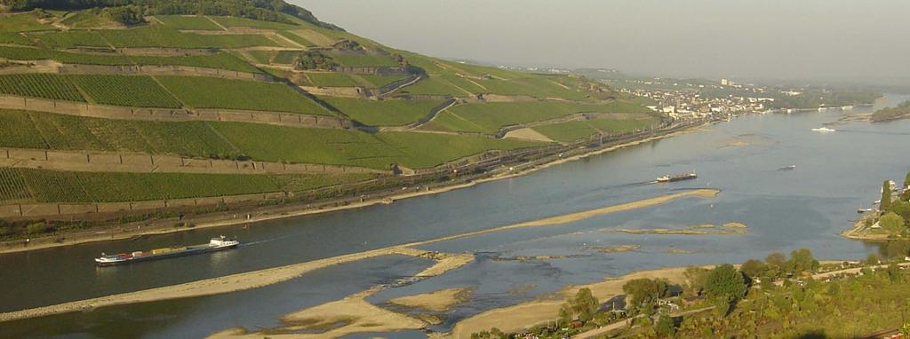
3 1. Background and project aim Rhine: Frequency and duration of low water periods might be increased due to future climate changes Adverse effects on navigation: Decrease of cost effectiveness due to reduction of maximum transportation capacity Decrease of ease and safety due to constriction of navigable fairway width Identification of adaptation measures to Rhine nearby Oberwesel during low water sustain navigation under extreme low water conditions Page 3
4 2. The research programme KLIWAS KLIWAS - Impacts of climate change on waterways and navigation Analysis of the vulnerability and development of potential adaptation measures 30 projects, financed by the Federal Ministry of Transport, Building and Urban Development (BMVBS) Research institutions: - Federal Waterways Engineering and Research Institute (BAW) - Deutscher Wetterdienst - DWD (National Meteorological Service) - Federal Institute of Hydrology (BfG) and - Federal Maritime and Hydrographic Agency (BSH) Page 4
 KLIWAS model chain 6.")
 (2009): Conference Proceedings KLIWAS Impacts of Climate Change on Waterways and Navigation in Germany First Status")
5 2. The research programme KLIWAS Ensemble and multi-model approach: combination of different IPCC emissions scenarios, global and regional climate models with subsequent models result in a span of projected quantities (e.g. discharge) KLIWAS model chain 6. Navigational models source: BMVBS (Ed.) (2009): Conference Proceedings KLIWAS Impacts of Climate Change on Waterways and Navigation in Germany First Status Conference, Bonn. (modified) 7. Economical models Page 5
 Transport performance: 2006: 43.")
 Source: Wasser- und Schifffahrtsdirektion Suedwest")
6 3. Hydraulic bottlenecks under changing hydrological conditions Area under investigation: Rhine 1320 km in total; navigable: 884 km MQ = 2300 m³/s (German Dutch border) Transport performance: 2006: 43.4 billion ton-kilometres (67.8 % of total German inland waterway transportation) Source: Wasser- und Schifffahrtsdirektion Suedwest (2007): Kompendium der Wasser- und Schifffahrtsdirektion Südwest. (modified) Page 6
7 3. Hydraulic bottlenecks under changing hydrological conditions changes of NM7Q (hydrol. summer) in near (red) and far (purple) future Hydraulic analysis (2D-HN model TELEMAC-2D): Present conditions of the waterway under changing hydrological conditions Identification of potential future bottlenecks e.g. gauge Kaub: : +/- 10 % : - 25 bis - 10 % Bandwidth of projected discharges Sensitivity analysis using reduced low water discharges GlQ - 5% up to GlQ - 25%. (QlQ 2002_Kaub = 750 m³/s; equivalent low Source: Nilson, E., Carambia, M., Krahe, P. (2010): Low Flow Changes in the Rhine River Basin, In: Results of the RheinBlick2050 Project. CHR Report No. I-23. water discharge) Page 7
 km 508 Rhine-km")
8 3. Hydraulic bottlenecks under changing hydrological conditions River Rhine reach Mainz St. Goar (Rhine-km ) Rhine-km guaranteed fairway-depth between Rhine-km 508 and 557 only 1,90 m below GlW 2002 (GlW 2002 : equivalent low water level) km 508 Rhine-km Page 8
9 3. Hydraulic bottlenecks under changing hydrological conditions Volume of shoals within the existing fairway per running river kilometre due to decreased water levels as a function of reduced low water discharges GlQ 2002 volume of shoals within fairway [m³] GlQ2002 GlQ2002-5% GlQ % GlQ % guaranteed fairway-depth below GlW m 1.90 m Rhine-km riverbed: condition 2004/ 2006 Page 9
10 4. River training options for adaptation to extreme low water situations Width-reduced, deepened low water fairway ( Fairway within fairway ) in addition to existing fairway; utilisation of excess depths reduction of maintenance costs compared to fairway deepening on entire width Flexible, temporarily acting or fixed regulating structures Page 10
 Additional safety distance between ship/ ship and ship/ bank Additional width due to a human")
11 4.1 Fairway within fairway Determination of the minimum fairway width: KLIWAS Project 4.04 Minimum width of fairways for safe and easy navigation Navigational dynamic models (PeTra1D, PeTra2D) Additional safety distance between ship/ ship and ship/ bank Additional width due to a human factor (Determination by using an autopilot including a human factor model) Source: Wurms, S., Schroeder, P.M., Weichert, R.B., Wassermann, S. (2010): Strategies to overcome the possibly restricted utilisation of fairways due to climate changes, River Flow 2010, , Braunschweig. Page 11
 Decrease of bed shear stresses within the dredging areas increase of aggradation tendencies Development of regulating structures aiming at the decrease of aggradation tendencies Dredging")
12 4.1 Fairway within fairway Hydraulic analysis of a deepened Fairway within fairway shows: Small decline of water levels (< 0.01 m) Decrease of bed shear stresses within the dredging areas increase of aggradation tendencies Development of regulating structures aiming at the decrease of aggradation tendencies Dredging area Fairway within fairway (depth of 2.10 m below WLGlQ % ) Page 12
 Dredging area Fairway within fairway (depth of 2.")
13 4.1 Fairway within fairway Example of a regulating structure for increasing bed shear stresses within a dredging area of the Fairway within fairway Training wall nearby Bingen (Rhine-km 525) Dredging area Fairway within fairway (depth of 2.10 m below WLGlQ % ) Page 13

14 4.1 Fairway within fairway Effect of the training wall: Increase of bed shear stresses within dredging areas No adverse effect on water levels during flood Future work: Optimisation of the regulating structure by means of a 2D-morphodynamic model Page 14


15 4.2 Flexible, temporarily acting regulating structures Potential option in case of non-applicability of fixed regulating temporary closing of a branch structures (no flood neutrality, obstacle for navigation, ecology, insufficient hydraulic effect ) Effect would be limited to low water discharges Constructional aspects further investigations required Example: Temporary closing of a branch of the river during low water Option for regulation? location of a shoal in case of reduced low water discharges Page 15
 Discharge through dammed branch for ecological reasons (approx. 0.2 m/s): Decrease of regulation effect of about 25 % at the shoal 1.")
16 4.2 Flexible, temporarily acting regulating structures Hydraulic effect of the temporary closing of the branch Gaining flow depth upstream of the bifurcation up to 0.3 m during GlQ % (approx m at the shoal 1.5 km upstream) Discharge through dammed branch for ecological reasons (approx. 0.2 m/s): Decrease of regulation effect of about 25 % at the shoal 1.5 km upstream of the bifurcation location of shoal in case of reduced low water discharges Page 16
17 5 Summary Rhine: Decrease of low water discharges expected in the far future hydraulic sensitivity analysis shows an increase of hydraulic bottlenecks Width-reduced, deepened Fairway within fairway : Improvement of the navigability during extreme low water from a technical point of view Flexible, temporarily acting regulating structures are potentially suitable for gaining flow depth during extreme low water periods further investigations required Potential of adaptation to sustain navigation under extreme low water conditions Page 17
 Bundesanstalt für Wasserbau (BAW) sven.wurms@baw.de michael.schroeder@baw.")
18 Thank you for your attention! KLIWAS project 4.03: Options for the regulation and adaptation of hydraulic engineering measures to climate induced changes of the discharge regime Dr.-Ing. S. Wurms Dr.-Ing. P.M. Schroeder Bundesanstalt für Wasserbau (BAW) Bundesanstalt für Wasserbau (BAW) (0) (0) Page 18
Investigation of the TMS Waldhof accident interim report
 Investigation of the TMS Waldhof accident interim report Communication from the Secretariat For your information, the Secretariat is forwarding in the annex the interim report (summary) by the commission
Infrastructure measures
 Infrastructure measures Juha Schweighofer via donau Österreichische Wasserstraßen GmbH Second ECCONET Stakeholder Workshop Amsterdam, November 2 nd, 2011 Contents Objectives in ECCONET Weather related
River Rhine - hydraulic and ship dynamic modelling
 River Flow 2010 - Dittrich, Koll, Aberle & Geisenhainer (eds) - 2010 Bundesanstalt für Wasserbau ISBN 978-3-939230-00-7 River Rhine - hydraulic and ship dynamic modelling Rolf entgraf & Thorsten Dettmann
Sediment management plans for the Dutch Rhine branches. Arjan Sieben Rijkswaterstaat Waterdienst
 zurück zum Inhaltsverzeichnis zur Kurzfassung Sediment management plans for the Dutch Rhine branches Arjan Sieben Waterdienst 8 oktober 2009 What happens downstream Lobith? Plans and trends Daily practice
Climate change impacts on water availability in three Mediterranean watersheds of Catalonia (NE Spain) Diana Pascual, Eduard Pla (CREAF)
 Diana Pascual, Eduard Pla (CREAF)") Climate change impacts on water availability in three Mediterranean watersheds of Catalonia (NE Spain) Diana Pascual, Eduard Pla (CREAF) 2011 International SWAT Conference INDEX 1.The project 2.Background
Climate change impacts on water availability in three Mediterranean watersheds of Catalonia (NE Spain) Diana Pascual, Eduard Pla (CREAF) 2011 International SWAT Conference INDEX 1.The project 2.Background
Integrated Waterway Management of the Danube in Austria
 Integrated Waterway Management of the Danube in Austria Thomas Hartl / Senior Expert Waterway Management via donau Österreichische Wasserstraßen-Gesellschaft mbh Vienna, October 14, 2014 Page 3 Figures
NNBF Examples and Flood Risk Reduction Measures in the Netherlands
 NNBF Examples and Flood Risk Reduction Measures in the Netherlands Quirijn Lodder Principal Advisor Coastal Flood Risk Management TU Delft NASA I like to read history books.. 2 I like to read history books..
Ship-Induced Waves Phenomenon, Influence Quantities and Measurement
 FEDERAL INSTITUE OF HYDROLOGY Koblenz FEDERAL WATERWAYS ENGINEERING AND RE- SEARCH INSTITUTE Karlsruhe Examinations of Technical-Biological Bank Protections on Inland Waterways Information Sheet: Ship-Induced
Paper Environmental friendly solutions to improve the navigation fairway of the Danube in Serbia
 Paper 166 - Environmental friendly solutions to improve the navigation fairway of the Danube in Serbia ZUIJDERWIJK Michel, MUSKATIROVIC Jasna, MITROVIC Ivan, TJERRY Soren, ZANETTI Roberto Witteveen+Bos,
Request Number IR1-12: Flow Passage. Information Request
 Request Number IR1-12: Flow Passage Information Request Provide additional information about the 100 metre flow passage channel scenario between the Westshore Terminals and the proposed Project terminal
ST. LOUIS SECTION PROJECT OF THE YEAR AWARD
 ST. LOUIS SECTION PROJECT OF THE YEAR AWARD Originality and Innovation The St. Louis Harbor Project is located in the Upper Mississippi River between the entrance to the Chain of Rocks Canal at River
First studies with the high-resolution coupled wave current model CWAM and other aspects of the project Sea State Monitor
 First studies with the high-resolution coupled wave current model CWAM and other aspects of the project Sea State Monitor Jens Kieser, Thomas Bruns German Meteorological Service (Deutscher Wetterdienst,
PORTS AUSTRALIA. PRINCIPLES FOR GATHERING AND PROCESSING HYDROGRAPHIC INFORMATION IN AUSTRALIAN PORTS (Version 1.5 November 2012)
") PORTS AUSTRALIA PRINCIPLES FOR GATHERING AND PROCESSING HYDROGRAPHIC INFORMATION IN AUSTRALIAN PORTS (Version 1.5 November 2012) PREFACE These Principles have been prepared by the Hydrographic Surveyors
PORTS AUSTRALIA PRINCIPLES FOR GATHERING AND PROCESSING HYDROGRAPHIC INFORMATION IN AUSTRALIAN PORTS (Version 1.5 November 2012) PREFACE These Principles have been prepared by the Hydrographic Surveyors
SPEECH. by Deputy Director-General of the Danube Commission s Secretariat. Mr. Pjotr Suvorov. (Linz, April 2013)
") SPEECH by Deputy Director-General of the Danube Commission s Secretariat Mr. Pjotr Suvorov on the 5 th Meeting of the Steering Group for Priority Area 1a of the EUSDR (Linz, 17-18 April 2013) At the 3
SPEECH by Deputy Director-General of the Danube Commission s Secretariat Mr. Pjotr Suvorov on the 5 th Meeting of the Steering Group for Priority Area 1a of the EUSDR (Linz, 17-18 April 2013) At the 3
Hydrodynamic and hydrological modelling to support the operation and design of sea ports
 Hydrodynamic and hydrological modelling to support the operation and design of sea ports Data needs and examples Martijn de Jong (port/nautical requirements, waves, currents) Sofia Caires (mean and extreme
The Tidal Elbe Concept Sustaining the Tidal River Seaport of Hamburg
 The Tidal Elbe Concept Sustaining the Tidal River Seaport of Hamburg 7 th international SedNet event 8. April 2011, Venice Wadden Sea North Sea MSFD Schleswig-Holstein Tidal Elbe Natura 2000 Lower Saxony
EFFECT OF LARGE-SCALE RESERVOIR OPERATION ON FLOW REGIME IN THE CHAO PHRAYA RIVER BASIN, KINGDOM OF THAILAND
 EFFECT OF LARGE-SCALE RESERVOIR OPERATION ON FLOW REGIME IN THE CHAO PHRAYA RIVER BASIN, KINGDOM OF THAILAND TAICHI TEBAKARI Hydraulic Engineering Research Group, Public Works Research Institute 1, Minamihara,
EXISTING AND PLANNED STRATEGIES AND ACTIONS CONNECTED WITH COASTAL PROTECTION IN ASPECT OF PREDICTED SEA LEVEL RISE
 EXISTING AND PLANNED STRATEGIES AND ACTIONS CONNECTED WITH COASTAL PROTECTION IN ASPECT OF PREDICTED SEA LEVEL RISE Andrzej Cieślak Long term coastal protection strategy In 2000 a new 1 Polish long term
Assessing salmon vulnerability to climate change
 Assessing salmon vulnerability to climate change Tim Beechie NW Fisheries Science Center Alisa Wade-Wilcox University of California, Santa Barbara The big question Will climate change negate salmon restoration
FIELD MEASUREMENTS OF SURFACE SUSPENDED SEDIMENT CONCENTRATION IN THE YANGTZE ESTUARY, CHINA
 International Conference on Estuaries and Coasts November 9-11, 2003, Hangzhou, China FIELD MEASUREMENTS OF SURFACE SUSPENDED SEDIMENT CONCENTRATION IN THE YANGTZE ESTUARY, CHINA Qing HE, Zhiying YU, Yuanye
THE INFLUENCE OF HYDROTECHNICAL STRUCTURES ON THE MINOR RIVERBED MORPHOLOGY OF THE DANUBE, IN THE BALA BRANCH - OLD DANUBE BIFURCATION AREA
 THE INFLUENCE OF HYDROTECHNICAL STRUCTURES ON THE MINOR RIVERBED MORPHOLOGY OF THE DANUBE, IN THE BALA BRANCH - OLD DANUBE BIFURCATION AREA Alina-Florina Nicolae 1, Puiu Lucian Georgescu 2, Constantin
Status of the Fairway Rehabilitation and Maintenance Master Plan for the Danube and its navigable tributaries (dated )
") Status of the Fairway Rehabilitation and Maintenance Master Plan for the Danube and its navigable tributaries (dated 23-11-2018) Key achievements since the endorsement of the Master Plan in 2014 The Fairway
Status of the Fairway Rehabilitation and Maintenance Master Plan for the Danube and its navigable tributaries (dated 23-11-2018) Key achievements since the endorsement of the Master Plan in 2014 The Fairway
SECTION 2 HYDROLOGY AND FLOW REGIMES
 SECTION 2 HYDROLOGY AND FLOW REGIMES In this section historical streamflow data from permanent USGS gaging stations will be presented and discussed to document long-term flow regime trends within the Cache-Bayou
Discussion on the Selection of the Recommended Fish Passage Design Discharge
 Discussion on the Selection of the Recommended Fish Passage Design Discharge Introduction The provision of fish passage is a requirement for most proposed culvert and bridge installations in Alberta, depending
How deep does an anchor penetrate the seafloor?
 6 th Workshop Seabed Acoustics, Rostock, November 14/15, 213 P3-1 How deep does an anchor penetrate the seafloor? Christian Maushake Federal Waterways Engineering and Research Institute Coastal Department
Implications of proposed Whanganui Port and lower Whanganui River dredging
 PO Box 637 Wanganui 4540 Attention: Rowan McGregor Dear Rowan 1 Summary We understand that it has been proposed to bring large vessels into the Port at Whanganui requiring the excavation of a channel up
Forschungsstelle Küste
 Forschungsstelle Küste Niedersächsisches Landesamt für Ökologie Reprint from Proceedings Hanz D. Niemeyer and Ralf Kaiser Evaluation of Design Water Levels and Design Wave Run-up for an Estuarine Coastal
Comparative variant analysis in using ship handling simulators with special respect to assess ease quality and human factor
 Comparative variant analysis in using ship handling simulators with special respect to assess ease quality and human factor Iribarren, Jose R.; Cal, Carlos; Atienza, Raul; Verdugo, Ismael Siport21, Madrid,
applied to Port Development and Inland Waterway Transport
 applied to Port Development and Inland Waterway Transport Wytze de Boer March 12, 2018 w.d.boer@marin.nl CHALLINGING WIND AND WAVES applied to port development and inland waterway transport AGENDA 1. Introduction
FIVE YEARS OF OPERATION OF THE FIRST OFFSHORE WIND RESEARCH PLATFORM IN THE GERMAN BIGHT FINO1
 FIVE YEARS OF OPERATION OF THE FIRST OFFSHORE WIND RESEARCH PLATFORM IN THE GERMAN BIGHT FINO1 Andreas Beeken, DEWI GmbH, Ebertstraße 96, D-26382 Wilhelmshaven Thomas Neumann, DEWI GmbH, Ebertstraße 96,
WAVE PRESSURE DISTRIBUTION ON PERMEABLE VERTICAL WALLS
 Abstract WAVE PRESSURE DISTRIBUTION ON PERMEABLE VERTICAL WALLS Hendrik Bergmann, Hocine Oumeraci The pressure distribution at permeable vertical walls is investigated within a comprehensive large-scale
Study of Constructing Asset Management System for Ground Anchor
 Study of Constructing Asset Management System for Ground Anchor Makoto ONO, Naoaki YAMASAKI, Yuji FUKUDA, Kyouji YANAGAWA, Yoshihiro TSUNEKAWA* Masanobu NAGANO** Toshinori SAKAI*** Soai co.,ltd* Kochi
Pipeline Flooding, Dewatering and Venting Dr Aidan O'Donoghue, Pipeline Research Limited, Glasgow, Scotland
 Pipeline Flooding, Dewatering and Venting Dr Aidan O'Donoghue, Pipeline Research Limited, Glasgow, Scotland Abstract Flooding, cleaning, gauging, dewatering and venting of offshore oil and gas pipelines
Quantifying Performance of Stream Simulation Culverts in the Chehalis Basin, WA
 Quantifying Performance of Stream Simulation Culverts in the Chehalis Basin, WA AUTHORS: Joe Richards, Environmental Science Associates Jane Atha, Washington Department of Fish & Wildlife Colin Thorne,
Multi-criteria Evaluation of Traffic Signal Control Manfred Boltze and Wei Jiang 1
 Multi-criteria Evaluation of Traffic Signal Control Manfred Boltze and Wei Jiang Transport Planning and Traffic Engineering, Technische Universität Darmstadt Future City 2017: Urban Sustainable Development
Modeling changes to the historic Lower Columbia River Estuary using Delft3D. Drew Mahedy Lumas Helaire Stefan Talke David Jay May 30, 2014
 Modeling changes to the historic Lower Columbia River Estuary using Delft3D Drew Mahedy Lumas Helaire Stefan Talke David Jay May 30, 2014 Comparison: Historic and Modern LCRE US Coastal Survey, 1868 Historic
Introduction. You may find detailed information about the network from the EuroVelo website: Page 1/5
 Including EuroVelo in the TEN-T Briefing Paper European Cyclists Federation Adam Bodor, Director of EuroVelo, Cycling Tourism and Regional Policy, a.bodor@ecf.com Ed Lancaster, Cycling Tourism and Regional
Chapter 8. Port hand buoy. Starboard hand buoy. Canadian Aids to Navigation System (CANS) 8.1 Introduction. 8.2 Lateral Buoys
 8.1 Introduction. 8.2 Lateral Buoys") Chapter 8 Canadian Aids to Navigation System (CANS) 8.1 Introduction Various buoys, beacons and signs are known as "Aids to Navigation" or "Navigation Aids". They are devices or systems external to the
Chapter 8 Canadian Aids to Navigation System (CANS) 8.1 Introduction Various buoys, beacons and signs are known as "Aids to Navigation" or "Navigation Aids". They are devices or systems external to the
Conclusions. on effective waterway infrastructure rehabilitation and maintenance on the Danube and its navigable tributaries. Danube Ministers Meeting
 Conclusions on effective waterway infrastructure rehabilitation and maintenance on the Danube and its navigable tributaries Danube Ministers Meeting Rotterdam 20 th June 2016 We, the Ministers and Heads
RISK ANALYSES OF THE SAFETY LEVEL OF GALLERIES
 - 34 - RISK ANALYSES OF THE SAFETY LEVEL OF GALLERIES Mayer G. 1, Sistenich C. 2, Zimmermann U. 3, Zulauf C. 4 1 PTV AG, Germany 2 Bundesanstalt für Straßenwesen (BASt), Germany; 3 BUNG Ingenieure AG,
Integrated bed-load and driftwood retention in Kien CH Findings from model based testing and the 2011 flood
 Integrated bed-load and driftwood retention in Kien CH Findings from model based testing and the 2011 flood Guido Lauber I Jürg Speerli 13th Congress INTERPRAEVENT 2016 Table of Contents I Chronology Floods
Ninilchik Harbor Page 2 of 11
 Ninilchik Harbor Ninilchik Harbor Page 2 of 11 Condition of Improvements 31 December 2017 Ninilchik Harbor, Alaska (CWIS No. 012640, 087345) Authorization Rivers and Harbors Act, 3 July 1958 (P.L. 85-500
MONITORING SEDIMENT TRANSPORT PROCESSES AT MANAVGAT RIVER MOUTH, ANTALYA TURKEY
 COPEDEC VI, 2003 in Colombo, Sri Lanka MONITORING SEDIMENT TRANSPORT PROCESSES AT MANAVGAT RIVER MOUTH, ANTALYA TURKEY Isikhan GULER 1, Aysen ERGIN 2, Ahmet Cevdet YALCINER 3 ABSTRACT Manavgat River, where
Case Studies. Georg Umgiesser and Natalja Čerkasova KU, Lithuania
 Case Studies Georg Umgiesser and Natalja Čerkasova KU, Lithuania Case 1: A beach in the Curonian Lagoon Beach Current situation in Curonian lagoon Beach in Kintai In the past, especially in Baltic inner
Fairway Rehabilitation and Maintenance Master Plan for the Danube and its Navigable Tributaries
 Fairway Rehabilitation and Maintenance Master Plan for the Danube and its Navigable Tributaries PA1a Working Group Session, Vukovar, 28 October 2014 Gudrun Maierbrugger, Technical Secretariat Priority
COUPLED MANAGEMENT STRATEGY LAKE CATHIE ESTUARY & COAST
 Lake Cathie Progress Association Inc. ABN 28 251 433 854 P.O. Box 247 Lake Cathie NSW 2445 PHONE/FAX: 02 6584 8211 EMAIL: r3packag@bigpond.com 20 th October 2009 Port Macquarie Hastings Council PO Box
A Government Service to State Owned Enterprise.
 Re-organization of Hydrographic Survey Operations in Finland A Government Service to State Owned Enterprise Kari Pohjola Hydro 2010, Rostock-Warnemuende, Germany, 02-05 November 2010 Re-organization of
HEC 26 Aquatic Organism Passage Design Manual Evolution & Application
 HEC 26 Aquatic Organism Passage Design Manual Evolution & Application Sven Leon, P.E., Hydraulics Engineer Federal Highway Administration 2015 Alaska Fish Passage Meeting October 13 14, 2015 VTRC, Juneau,
APPENDIX C. Fluvial and Tidal Hydraulics Report
 APPENDIX C Fluvial and Tidal Hydraulics Report BUENA VISTA LAGOON ENHANCEMENT PROJECT FLUVIAL AND TIDAL HYDRAULICS ANALYSES Prepared for: SANDAG 401 B Street, Suite 800 San Diego, California 92101 Contact:
Case Studies Georg Umgiesser and Natalja Čerkasova KU, Lithuania
 Case Studies Georg Umgiesser and Natalja Čerkasova KU, Lithuania Case 1: A beach in the Curonian Lagoon 1 Beach Current situation in Curonian lagoon Beach in Kintai In the past, especially in Baltic inner
Greenup Lock Filling and Emptying System Study
 Fourth LACCEI International Latin American and Caribbean Conference for Engineering and Technology (LACCET 2006) Breaking Frontiers and Barriers in Engineering: Education, Research and Practice 21-23 June
Overview Vessel Types on the Danube
 Overview Vessel Types on the Danube 1. Introduction This document describes the most important vessel types for Danube IWT. In the first part of the document, various vessel types and their load capacities
THE EFFECT OF VARIOUS DIKE REINFORCEMENT ALTERNATIVES ON THE FLOOD SAFETY ASPECTS OF THE DELTADIKE CONCEPT
 THE EFFECT OF VARIOUS DIKE REINFORCEMENT ALTERNATIVES ON THE FLOOD SAFETY ASPECTS OF THE DELTADIKE CONCEPT Preliminary Final Report Master Thesis Written by Simon den Hengst Delft, 08 December 2012 Recent
Hydrological Condition Report including the issues of High Flow Fluctuation in Chiang Saen
 Hydrological Condition Report including the issues of High Flow Fluctuation in Chiang Saen Technical Symposium for ESCIR and MRC on Social Impact Assessment in River Basin Management Sothea KHEM, HENG
Rock Ramp Design Guidelines. David Mooney MS Chris Holmquist-Johnson MS Drew Baird Ph.D. P.E. Kent Collins P.E.
 Rock Ramp Design Guidelines David Mooney MS Chris Holmquist-Johnson MS Drew Baird Ph.D. P.E. Kent Collins P.E. Rock Ramp Design Guidelines OUTLINE Local and System Interactions with Rock Ramps Ramp Geometry
FAIRway Danube. a milestone for the realization of the Masterplan of the Danube and its navigable tributaries , Katja Rosner / viadonau
 FAIRway Danube a milestone for the realization of the Masterplan of the Danube and its navigable tributaries 15.11.2016, Katja Rosner / viadonau Agenda FAIRway Danube in a nutshell Developments in selected
SUPERGEN Wind Wind Energy Technology
 SUPERGEN Wind Wind Energy Technology Wave Loading on Wind Turbine Sub-Structures Jamie Luxmoore Lancaster University SUPERGEN Wind Energy Technologies Consortium Phase 2 3 rd Training Seminar, Loughborough
Paper RCC Jack Jetty and Bamboo Submerged Vanes Application for Navigation Fairway in Ganga River of India
 Paper 173 - RCC Jack Jetty and Bamboo Submerged Vanes Application for Navigation Fairway in Ganga River of India SHARMA NAYAN; NAYAK ANUPAMA Professor, Indian Institute of Technology Roorkee India Email:
Innovation Electrical Industry
 Position Paper Potential for Optimising the Use of SF6 in Switchgear Automotive Industry 4.0 Energy Efficiency Digitalisation 4.0 Innovation Electrical Industry 16 November 2016 ZVEI German Electrical
Capacity of transport infrastructure networks
 Most infrastructure extension work is concentrated on roads. The total length of the motorway network has increased dramatically during the past two decades (about 3 % per year). Construction of the high-speed
Hydrographic Surveying Methods, Applications and Uses
 Definition: Hydrographic Surveying Methods, Applications and Uses It is the branch of surveying which deals with any body of still or running water such as a lake, harbor, stream or river. Hydrographic
Adopted Regulation Strategy Lake of the Woods Control Board Regulation Meeting March 12, 2013
 Adopted Regulation Strategy Lake of the Woods Control Board Regulation Meeting March 12, 2013 The Lake of the Woods Control Board held a Regulation Meeting March 12, 2013 in Kenora. The strategy was formulated
TOWARDS A BIKE-FRIENDLY CANADA A National Cycling Strategy Overview
 TOWARDS A BIKE-FRIENDLY CANADA A National Cycling Strategy Overview NationalCyclingStrategFrameworkv3.indd 1 Potential for this modal shift can be found in municipalities of all sizes, in every population
Incorporating Geomorphic Processes and Sediment Dynamics into Salmonid Habitat Restoration Design
 Salmonid Restoration Federation 35 th Annual Salmonid Restoration Conference Davis, CA Incorporating Geomorphic Processes and Sediment Dynamics into Salmonid Habitat Restoration Design Concurrent Session:
Waterway management projects co-funded by CEF Programme rkm Danube section in Hungary -
 Waterway management projects co-funded by CEF Programme - 1811-1433 rkm Danube section in Hungary - PÁL KÖTÉL, KÁROLY GOMBÁS MSc in water engineering Fluvial flod protection, deputy department leader NORTH-TRANSDANUBIAN
Questionnaire for reporting on progress made since 2009 on the attainment of the Amsterdam Goals
 Questionnaire for reporting on progress made since 2009 on the attainment of the Amsterdam Goals Section A: Information about the preparation of the replies to the questionnaire Country Name of officer
E. Agu, M. Kasperski Ruhr-University Bochum Department of Civil and Environmental Engineering Sciences
 EACWE 5 Florence, Italy 19 th 23 rd July 29 Flying Sphere image Museo Ideale L. Da Vinci Chasing gust fronts - wind measurements at the airport Munich, Germany E. Agu, M. Kasperski Ruhr-University Bochum
COST EFFECTIVE STORAGE CAPACITY INCREASE FOR ALUMINA TAILINGS DISPOSAL AREA THROUGH SPILLWAY OPTIMISATION
 COST EFFECTIVE STORAGE CAPACITY INCREASE FOR ALUMINA TAILINGS DISPOSAL AREA THROUGH SPILLWAY OPTIMISATION Abstract Lonie I * Tailings and Dams, GHD Brisbane, QLD, Australia Queensland Alumina Limited operates
Monitoring system on implementation of waterway maintenance declaration & short-term measures
 Monitoring system on implementation of waterway maintenance declaration & short-term measures Linz, 16 April 2013 Thomas Hartl Joint Technical Secretariat PAC 1a Slide No. 2 Status: April 2013 Slide No.
Blue cod 5 (BCO5) pot mesh size review
 pot mesh size review") Blue cod 5 (BCO5) pot mesh size review Discussion Document MPI Discussion Paper No: 2017/01 Prepared for public consultation by the Ministry for Primary Industries ISBN No: 978-1-77665-454-3 (o) ISSN No:
Blue cod 5 (BCO5) pot mesh size review Discussion Document MPI Discussion Paper No: 2017/01 Prepared for public consultation by the Ministry for Primary Industries ISBN No: 978-1-77665-454-3 (o) ISSN No:
Paper for consideration by ENC Working Group. Use of AU6 ENC cells as an option for Bathymetric ENCs (benc)
") Paper for consideration by ENC Working Group Use of AU6 ENC cells as an option for Bathymetric ENCs (benc) Submitted by: Alvaro Sanchez (AHS) Executive Summary: Compilation of high density bathymetric
Paper for consideration by ENC Working Group Use of AU6 ENC cells as an option for Bathymetric ENCs (benc) Submitted by: Alvaro Sanchez (AHS) Executive Summary: Compilation of high density bathymetric
Assessing the spatial dynamics of Small Scale Coastal Fisheries of the Baltic Sea. A Geographic Information System based approach
 Assessing the spatial dynamics of Small Scale Coastal Fisheries of the Baltic Sea A Geographic Information System based approach Eva Papaioannou 1, Athanasios Vafeidis 1, Jörn Schmidt 2, Martin Quaas 2
Supplementary cementitious Materials
 Supplementary cementitious Materials Karen Scrivener WORKING DOCUMENT Most promising approach reducing the clinker factor CO 2 Process optimisation clinker factor Clinker Gypsum Cement SCMs Supplementary
Information Paper for SAN (CI-4) Identifying the Spatial Stock Structure of Tropical Pacific Tuna Stocks
 Identifying the Spatial Stock Structure of Tropical Pacific Tuna Stocks") Current knowledge, key uncertainties and future research directions for defining the stock structure of skipjack, yellowfin, bigeye and South Pacific albacore tunas in the Pacific Ocean Information Paper
Current knowledge, key uncertainties and future research directions for defining the stock structure of skipjack, yellowfin, bigeye and South Pacific albacore tunas in the Pacific Ocean Information Paper
Grip on speed. A multi-stakeholder approach to road safety
 Grip on speed A multi-stakeholder approach to road safety Authors: Erik Donkers VIA, traffic consultancy & software, The Netherlands Berry de Jong SRE (Eindhoven Urban Region), The Netherlands Polis Conference
CO 2 reduction due to "topography orientated" voyage-planning and navigation. -Prerequisites of ship handling simulators as training tool-
 reduction due to "topography orientated" voyage-planning and navigation -Prerequisites of ship handling simulators as training tool- Development Centre for Ship Technology and Transport Systems TopoNav
Water Resources Report RKLD Annual Meeting July 30, 2016
 Water Resources Report RKLD Annual Meeting 2016 July 30, 2016 Topics Hydrology Report Indianford Dam trash rack cleanout performance Experimental Project update Review of PAS project Twin floods- 1 to
Coastal Harbors and Waterways, NC (Shallow Draft Navigation) (O&M)
 (O&M)") Coastal Harbors and Waterways, NC (Shallow Draft Navigation) (O&M) Shallow draft coastal harbors include a subsistence harbor at Silver Lake CONGRESSIONAL DISTRICT: NC 3 and 7 DATE: 23 February 2015 1.
Coastal Harbors and Waterways, NC (Shallow Draft Navigation) (O&M) Shallow draft coastal harbors include a subsistence harbor at Silver Lake CONGRESSIONAL DISTRICT: NC 3 and 7 DATE: 23 February 2015 1.
FISHERIES BLUE MOUNTAINS ADAPTATION PARTNERSHIP
 FISHERIES A warming climate, by itself, substantially affects the hydrology of watersheds in the Blue Mountains. Among the key hydrologic changes projected under all scenarios for the 2040s and beyond
Innovative Technologies for a Resilient Marine Transportation System
 Innovative Technologies for a Resilient Marine Transportation System Transportation Research Board MG John Peabody, P.E. Deputy Commanding General for Civil and Emergency Operations, U.S. Army Corps of
MEMORANDUM OF UNDERSTANDING ON THE CONSERVATION OF MIGRATORY BIRDS OF PREY IN AFRICA AND EURASIA
 MEMORANDUM OF UNDERSTANDING ON THE CONSERVATION OF MIGRATORY BIRDS OF PREY IN AFRICA AND EURASIA The Signatories Recalling that the Convention on the Conservation of Migratory Species of Wild Animals,
15 th Meeting of the Steering Group for Priority Area 1a of the EUSDR Vienna, Austria 09 October 2018
 EU Strategy for the Danube Region Priority Area 1a To improve mobility and multimodality: Inland waterways 15 th Meeting of the Steering Group for Priority Area 1a of the EUSDR Vienna, Austria 09 October
Gayaza High School Geography Department
 THE DEVELOPMENT OF THE SAINT LAWRENCE SEAWAY This is an inland water way partly artificially constructed from the Gulf of St. Lawrence to the Western end of Lake Superior. It covers a distance of 3,800
Wave energy converter effects on wave and sediment circulation
 Wave energy converter effects on wave and sediment circulation Grace Chang and Craig Jones Integral Consulting Inc. cjones@integral-corp.com; gchang@integral-corp.com Jesse Roberts, Kelley Ruehl, and Chris
Official Journal of the European Union L 248/17
 22.9.2007 Official Journal of the European Union L 248/17 COUNCIL REGULATION (EC) No 1100/2007 of 18 September 2007 establishing measures for the recovery of the stock of European eel THE COUNCIL OF THE
PERSONALISED TRAVEL PLANNING IN MIDLETON, COUNTY CORK
 PERSONALISED TRAVEL PLANNING IN MIDLETON, COUNTY CORK Elaine Brick Principal Transport Planner AECOM Abstract Smarter Travel funding was awarded to the Chartered Institute of Highways and Transportation
G u i d e l i n e C Y C L I N G C O S T - E F F E C T I V E M E A S U R E S Version: November 2015
 G u i d e l i n e C Y C L I N G C O S T - E F F E C T I V E M E A S U R E S Version: November 2015 Cycling is on the rise. For some time now, European cities have been increasingly paying attention to
MINISTRY OF ENVIRONMENT ENVIRONMENTAL STEWARDSHIP DIVISION FISH AND WILDLIFE BRANCH. Horsefly River Angling Management Plan
 MINISTRY OF ENVIRONMENT ENVIRONMENTAL STEWARDSHIP DIVISION FISH AND WILDLIFE BRANCH Horsefly River Angling Management Plan January 30 th, 2006 Area/Fishery Description The Horsefly River watershed provides
Wave climate in the Baltic Sea 2014
 Wave climate in the Baltic Sea 2014 Authors: Heidi Pettersson, Marine Research, Finnish Meteorological Institute Helma Lindow, Swedish Meteorological and Hydrological Institute Thorger Brüning, Bundesamt
Reporting on progress made since 2009 on the attainment of the Amsterdam Goals
 Reporting on progress made since 2009 on the attainment of the Amsterdam Goals Following the Third High-level Meeting on Transport, Health and Environment in January 2009, the Steering Committee and its
Sea-going vessel versus wind turbine
 Collision risk at high sea Sea-going vessel versus wind turbine Offshore wind power: Wind turbines off the German coast generally represent obstacles in the traffic routes of ships. What if a large sea-going
 Page 1 of 6 Nav-Aid Basics Unlike the roads and highways that we drive on, the waterways we go boating on do not have road signs that tell us our location, the route or distance to a destination, or of
Are Hurricanes Becoming More Furious Under Global Warming?
 Are Hurricanes Becoming More Furious Under Global Warming? Z H A N L I U N I V E R S I T Y O F U T A H A T M O S P H E R I C S C I E N C E S D E P A R T M E N T T U E S D A Y, M A R C H 1 6, 2 0 1 0 OUTLINE
Wind tunnel acoustic testing of wind generated noise on building facade elements
 See discussions, stats, and author profiles for this publication at: https://www.researchgate.net/publication/307638896 Wind tunnel acoustic testing of wind generated noise on building facade elements
Five Counties Salmonid Conservation Program - Fish Passage Design Workshop. February 2013
 Program - Aquatic Organisms and Stream Crossings Ecological Connectivity A watershed is a network of channels that drain a common boundary. Channel characteristics formed by interaction of precipitation,
Intelligent Transport Systems to support sustainable mobility. Steffen Rasmussen, Head of Department Traffic and Urban Life - City of Copenhagen
 Intelligent Transport Systems to support sustainable mobility Steffen Rasmussen, Head of Department Traffic and Urban Life - City of Copenhagen COPENHAGEN - CAPITAL OF DENMARK INHABITANTS Municipality
Lessons to be learnt from Mekong River for Asia
 28 January 2011 Lessons to be learnt from Mekong River for Asia Gary Kleyn FDI Research Manager Global Food and Water Crises Research Programme Summary South East Asia will face increasing problems as
Action plan to promote local mobility in North Rhine-Westphalia (Germany)
") Action plan to promote local mobility in North Rhine-Westphalia (Germany) Ulrich Malburg supported by Peter London 1 Local Mobility Local Mobility is non-motorized transport: Walking, bicycle riding as
Action plan to promote local mobility in North Rhine-Westphalia (Germany) Ulrich Malburg supported by Peter London 1 Local Mobility Local Mobility is non-motorized transport: Walking, bicycle riding as
THE CHALLENGES OF A LARGE-AREA BATHYMETRIC SURVEY
 THE CHALLENGES OF A LARGE-AREA BATHYMETRIC SURVEY Agenda: - Introduction - Tender - Project Planning - Survey - Processing - Delivery - Conclusion 2 Introduction We know less of the oceans at our feet,
Environmental. Effects of Dredging
 Envi~onmental Effects of Dredging Technical Notes THE VALUE OF GRAVEL DISPOSAL MOUNDS IN RIVER SIDE CHANNELS FOR FRESHWATER MUSSELS PURPOSE: This note provides information on the value of gravel disposal