TULSA INTERNATIONAL AIRPORT ECONOMIC DEVELOPMENT PROJECT PLAN
|
|
|
- Alfred Eric Hill
- 6 years ago
- Views:
Transcription

1 Adopted, 2016 TULSA INTERNATIONAL AIRPORT ECONOMIC DEVELOPMENT PROJECT PLAN A PROJECT OF: THE CITY OF TULSA IN COOPERATION WITH: TULSA COUNTY TULSA INTERNATIONAL AIRPORT DEVELOPMENT TRUST TULSA AIRPORTS IMPROVEMENT TRUST WITH THE ASSISTANCE OF: JEFF MULDER, A.A.E. DIRECTOR OF AIRPORTS ALEXIS HIGGINS, A.A.E. DEPUTY DIRECTOR OF MARKETING JEFF HOUGH, P.E. DEPUTY DIRECTOR OF ENGINEERING AND FACILITIES NANCY MCNAIR AIRPORT LEGAL COUNSEL CARL REMUS DEPUTY DIRECTOR OF ADMINISTRATION AND FINANCE AND: LESLIE V. BATCHELOR, PRESIDENT (405) NORTH HARVEY, SUITE 100 OKLAHOMA CITY, OK 73102
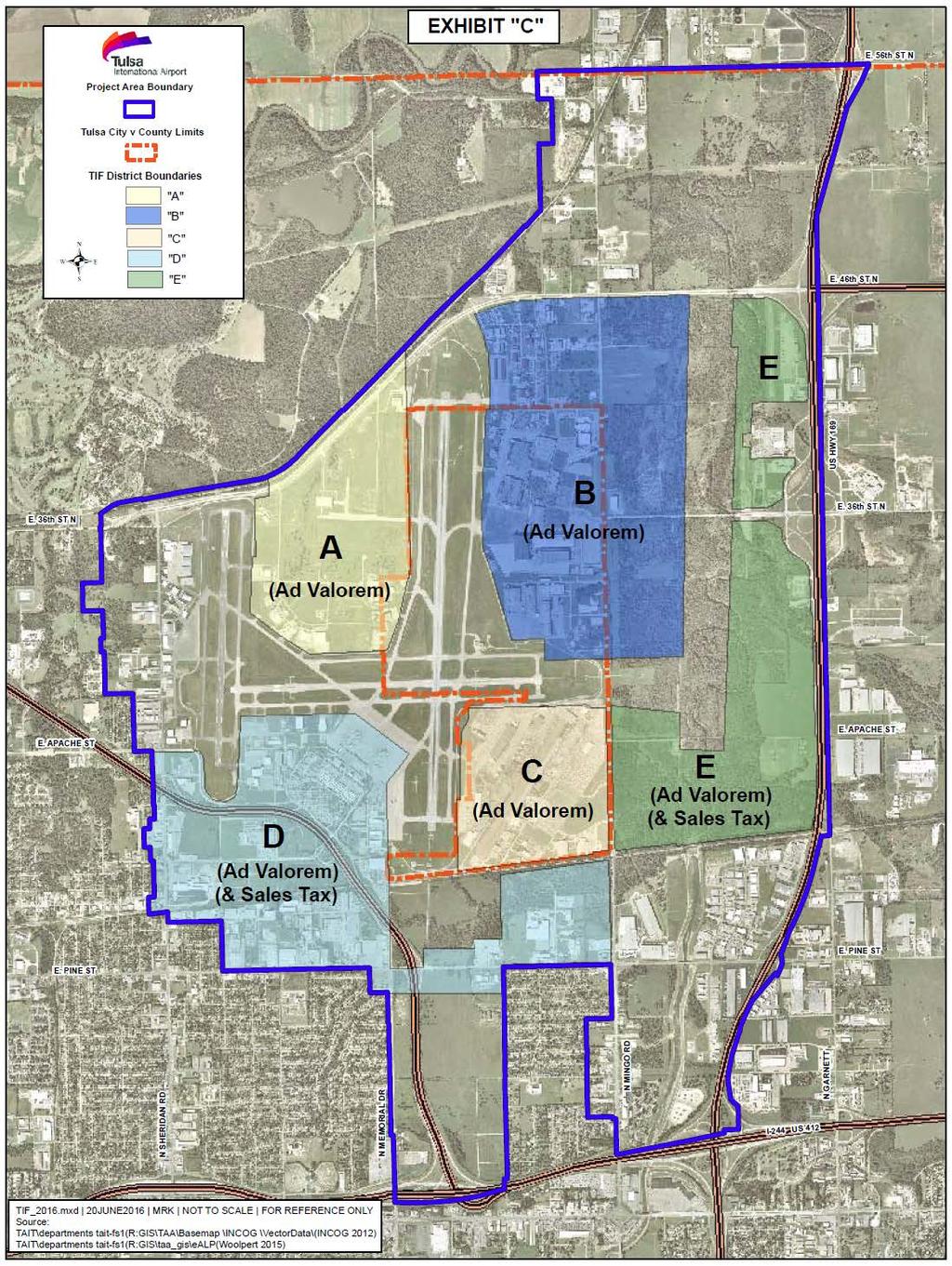
2 TULSA INTERNATIONAL AIRPORT ECONOMIC DEVELOPMENT PROJECT PLAN I. DESCRIPTION OF PROJECT As the hub of aerospace activity for the region, Tulsa International Airport ( Airport or TUL ) seeks to continue and expand its support of the growth of the aerospace industry by generating development on the Airport s 700+ acres of property. Aerospace is one of the State s largest industries, and Tulsa is ranked eighth nationally for the size of its aerospace engines manufacturing cluster and twentieth for its defense-related cluster. TUL s central location in the Midwest is easily accessible by a multi-modal transportation network. The purpose of this Project Plan is to provide a planning framework and funding mechanism for a substantial portion of the local public investment required to support the area s aerospace economy and to generate additional, related private investment in the area. New public infrastructure from taxilanes, hangars, and storage facilities to water and sewer lines, access roads, and building pads is essential to both the public and private developments in the Airport area. While the cost of this infrastructure is substantial ($ Million), so is the potential new private investment ($800 $900 Million). A single development or expansion by a commercial aviation company could generate private investment of $ Million. Multiple, smaller commercial developments are possible under this Project Plan, including hotels, offices, and retail establishments. An integral part of the development strategy will be the negotiation of agreements under which private development commitments will be secured in exchange for the public investments. One element of this will be the appropriate disposition of publicly-owned property by lease or sale, to convert undeveloped or underdeveloped land into revenue-generating property. Another element will be to promote the development and construction of privately-owned buildings and other improvements on property that remains in public ownership. Such private improvements will generate tax increments, which will produce funding for the public costs of development. Implementation of the Project Plan will help the Airport achieve its objectives of diversifying its revenue sources, maintaining its facilities, and supporting air service development. By enhancing the tax base, the Airport Project Plan will have a long-term positive impact on all the affected taxing jurisdictions and will improve the quality of life for residents of the City of Tulsa and Tulsa County. II. BOUNDARIES OF PROJECT AREA AND INCREMENT DISTRICTS The Project Area is the area in which Project activities will take place and Project Costs will be incurred. The Project Area can be generally described as the area bounded by North Port Road, East 56th Street North, Highway 169, portions of Pine Street and Interstate-244, and extending just a little west of Sheridan Road. The legal description of the Project Area is contained on Exhibit A. The Increment Districts will generate the revenues to assist in paying or financing eligible Project Costs. For purposes of this Project Plan document, the Increment Districts shall be referred to as Increment Districts A, B, C, D, and E, (and collectively referred to as the Increment Districts ). Once the commencement date of each Increment District is determined, the Increment District shall be renamed as Increment District Number, City of Tulsa or Increment District Number, Tulsa County, as appropriate, by assigning the next consecutive number for increment districts of the City of Tulsa or 1
3 Tulsa County, in accordance with 62 O.S. 856(3). The legal descriptions of Increment Districts are contained on Exhibit B. The boundaries of the Project Area and Increment Districts are illustrated on Exhibit C. In accordance with the legislative guideline found in 62 O.S. 852(2), areas where investment, development, and economic growth would occur anyway have been excluded. III. ELIGIBILITY OF PROJECT AREA The Project Area qualifies as an enterprise area, as defined by 62 O.S. 853(6), because it lies within an enterprise zone designated by the Oklahoma Department of Commerce. The Project Area also qualifies as a reinvestment area, as defined by 62 O.S. 853(17), due to the need for public improvements to catalyze the development of the area. IV. OBJECTIVES The principal objectives of the Project and the Increment Districts are: A. To facilitate the development of property at the Airport, thus helping to diversify the revenue sources that support the ongoing costs of operating, maintaining, and improving Airport facilities. B. To provide a funding mechanism for a substantial portion of the local public investment required to support the Airport s aerospace economy. C. To support the existing major businesses and employers in the Project Area. D. To serve as a catalyst for retaining or expanding employment, to attract major investment in the area, and reverse economic stagnation. E. To preserve and enhance the tax base and make possible investment, development, and economic growth that would otherwise be difficult without the Project and the apportionment of incremental sales tax revenues. F. To stimulate private commitments to invest and reinvest in the Project Area. G. To create and expand commercial activities in the area, including hotels, retail, and travel and tourism related attractions and amenities. V. STATEMENT OF PRINCIPAL ACTIONS Implementation actions for the Project, including all necessary, appropriate and supportive steps will consist principally of the following, to be undertaken primarily by the Tulsa International Airport Development Trust ( TIADT ): A. Project planning, design, and approval. B. Coordination and cooperation between Tulsa County, the City of Tulsa, and the appropriate City Trusts for joint and/or coordinated endeavors under this Project Plan, including through appropriate interlocal agreements. 2
4 C. Construction and/or repair of public improvements, streets, streetscapes, utilities and other public infrastructure and facilities, including but not limited to taxilanes, access roads, water and sewer lines, and sidewalks. D. Preparation of development sites, including by grading, constructing building pads, and providing utilities and infrastructure. E. Negotiation of development agreements, leases, and other contracts under which private development commitments will be secured in exchange for the public investments. VI. ESTABLISHMENT OF THE INCREMENT DISTRICTS A. This Project Plan creates five increment districts, three of which are ad valorem tax increment districts and two of which are sales, hotel, and ad valorem tax increment districts. Each increment district shall commence as of the date determined by the City Council of the City of Tulsa, and as authorized by the Tulsa County Commissioners, for that district in accordance with 62 O.S. 856(B) within thirty days of request by TIADT. 1. The increment of ad valorem taxes from Increment District A in excess of the base assessed value of Increment District A may be apportioned from time to time to pay Project Costs (as defined in Section VIII, below) authorized by Section VIII of this Plan for a period not to exceed 25 fiscal years or the period required for the payment of such authorized Project Costs, whichever is less. 2. The increment of ad valorem taxes from Increment District B in excess of the base assessed value of Increment District B may be apportioned from time to time to pay Project Costs (as defined in Section VIII, below) authorized by Section VIII of this Plan for a period not to exceed 25 fiscal years or the period required for the payment of such authorized Project Costs, whichever is less. 3. The increment of ad valorem taxes from Increment District C in excess of the base assessed value of Increment District C may be apportioned from time to time to pay Project Costs (as defined in Section VIII, below) authorized by Section VIII of this Plan for a period not to exceed 25 fiscal years or the period required for the payment of such authorized Project Costs, whichever is less. 4. The increment of ad valorem taxes from Increment District D in excess of the base assessed value of Increment District D may be apportioned from time to time to pay Project Costs (as defined in Section VIII, below) authorized by Section VIII of this Plan for a period not to exceed 25 years or the period required for the payment of such authorized Project Costs, whichever is less. 5. The increment of City of Tulsa sales and hotel taxes generated by Increment District D, as determined by a formula to be approved by resolution of the Tulsa City Council in accordance with the Local Development Act, may be used to pay Project Costs authorized pursuant to Section VIII of this Plan, for a period not to exceed 25 fiscal years from the effective date of Increment District D, as provided by law, or the period required for payment of the Project Costs authorized pursuant to Section VIII of this Plan, whichever is less. Sales and use taxes 3
5 include all proceeds and receipts derived from all sales taxable under the sales tax code of Oklahoma (which include but are not limited to sales of construction materials). 6. The increment of ad valorem taxes from Increment District E in excess of the base assessed value of Increment District E may be apportioned from time to time to pay Project Costs (as defined in Section VIII, below) authorized by Section VIII of this Plan for a period not to exceed 25 fiscal years or the period required for the payment of such authorized Project Costs, whichever is less. 7. The increment of City of Tulsa sales and hotel taxes generated by Increment District E, as determined by a formula to be approved by resolution of the Tulsa City Council in accordance with the Local Development Act, may be used to pay Project Costs authorized pursuant to Section VIII of this Plan, for a period not to exceed 25 fiscal years from the effective date of Increment District E, as provided by law, or the period required for payment of the Project Costs authorized pursuant to Section VIII of this Plan, whichever is less. Sales and use taxes include all proceeds and receipts derived from all sales taxable under the sales tax code of Oklahoma (which include but are not limited to sales of construction materials). B. During the period of apportionment, the apportionment fund (1) shall be available to pay Project Costs under Section VIII, (2) shall constitute special funds of TIADT, and (3) shall not be subject to annual appropriation as a part of the general fund of the City. VII. PROJECT AND INCREMENT DISTRICT AUTHORIZATIONS A. TIADT is designated and authorized as the principal public entity to carry out and administer the provisions of this Project Plan and to exercise all powers necessary or appropriate thereto as provided in the Local Development Act, 62 O.S TIADT, or another public entity designated by the City, is authorized and designated to carry out those provisions of the Project related to issuance of bonds or notes as provided in 62 O.S. 854(B) and 863 of the Local Development Act, subject to approval of the governing body of the City of any specific notes or bonds. Such public entity of the City is authorized to assist in carrying out this Project Plan and to exercise all powers necessary or appropriate thereto pursuant to Sections 854, Title 62 of the Oklahoma Statutes, except for approval of this Project Plan and those powers enumerated in paragraphs 1, 2, 3, 4, 7, 13 and 16 of Section 854, Title 62. As a public entity designated by the City, the TIADT, or another public entity designated by the City is authorized to: (1) issue tax apportionment bonds or notes, or both; (2) incur Project Costs, pursuant to Section VIII of this Project Plan; (3) provide funds to or reimburse TAIT or the City for the payment of Project Costs and other costs incurred in support of the implementation of the Project; and (4) incur the cost of issuance of bonds for payment of such costs and to accumulate appropriate reserves, if any, in connection with them. Project Costs shall mean (a) the public costs authorized to be paid by apportioned tax increments pursuant to Section VIII of this Project Plan, and (b) costs necessary or appropriate to implement this Project Plan other than costs authorized by Section VIII, which may be authorized without amendment to this Project Plan. B. The Tulsa Airports Improvement Trust, a public trust ( TAIT ), is authorized and designated as an additional public entity to assist in carrying out the provisions of this Project Plan and to incur Project Costs with respect to airport improvements and operations within its responsibilities, in accordance with budgetary allocations for such activities approved in accordance with this Project Plan 4
6 and development agreements approved by TIADT as authorized by this Project Plan. Any Project Costs incurred by TAIT will be reimbursed by TIADT. C. The Director of Airports, Jeff Mulder, his successor in office, or his designee shall be the person in charge of implementation of the Project Plan in accordance with the provisions, authorizations, and respective delegations of responsibilities contained in this Project Plan. The Director of Airports, his successor in office, or his designee is authorized to empower one or more designees to exercise responsibilities in connection with Project implementation. VIII. BUDGET OF ESTIMATED PROJECT COSTS TO BE FINANCED BY TAXES APPORTIONED FROM THE INCREMENT DISTRICTS A. Project Costs. The Project Costs will be financed by the apportionment of tax increments from Increment Districts. Project Costs are expected to be incurred throughout the Project Area in these categories: Public Improvements and Infrastructure $ 61,000, Development Financing Assistance $ 33,000, Project Implementation and Contingency $ 4,000, TOTAL $ 98,000, plus financing costs, costs of issuance, necessary or appropriate reserves, and interest on repayment of Project Costs. B. Generation of Revenue. The revenues expected to be generated from the Increment Districts within the Project Area and authorized for payment of Project Costs throughout the Project Area are as follows: Increment District A $ 39,000, Increment District B $ 24,000, Increment District C $ 6,000, Increment District D $ 14,000, Increment District E $ 15,000, TOTAL $ 98,000, plus revenues sufficient to cover financing costs, costs of issuance, necessary or appropriate reserves, and interest on repayment of Project Costs, allocated appropriately to the Increment Districts. C. Additional Costs. Additional costs necessary or appropriate to implement this Project Plan that are to be financed by other than apportioned tax increments may be approved by the TIADT at any time. The provisions of 5
7 this Section VIII are not a limitation on Project Costs to be financed by other than apportioned sales tax increments. IX. FINANCING REVENUE SOURCES A. Financing Authorizations. The implementation of the Project Plan shall be financed in accordance with financial authorizations, including both fund and asset transfers, authorized from time to time by the TIADT. B. Financing Revenue Sources. The revenue sources expected to finance Project Costs authorized by Section VIII are the portion of the increments attributable to investment and development within each Increment District. Project Costs will be paid by the City and/or the TIADT. C. Financial Reports and Audits. The development activities undertaken by the TIADT, pursuant to this Project Plan, shall be accounted for and reported by the appropriate and necessary annual fiscal year audits and reports. D. Other Necessary and Supporting Costs. The TIADT, or another public entity designated by the City pursuant to Section VII, is authorized to issue bonds and notes and to apply for and obtain grants from other sources for costs incurred or to be incurred in connection with the project and the construction of improvements therein in addition to Project Costs to be financed pursuant to Section VIII. X. PRIVATE AND PUBLIC INVESTMENTS EXPECTED FOR THE PROJECT A. Private and Public Investments Expected from the Project and Increment District Nos. A through E. The total estimated private investment is approximately $ Million, in addition to an estimated $200 Million in aggregate public investment, including federal funds. Private investment in the area is expected to consist of business and commercial development. Public investment will include infrastructure improvements, especially taxilanes, access roads, water and sewer lines, and sidewalks, as well as development financing assistance on appropriate private projects. B. Public Revenue Estimated to Accrue from the Project and Increment District Nos. A through E. The estimated increase in tax increment revenues including ad valorem, sales, and hotel tax increment revenues which will serve as the revenue source for financing the Project Costs authorized by Section VIII, is the public revenue directly attributable to the Project defined by establishment of the Increment Districts. The City and the State will experience increases in sales and hotel tax revenues that 6
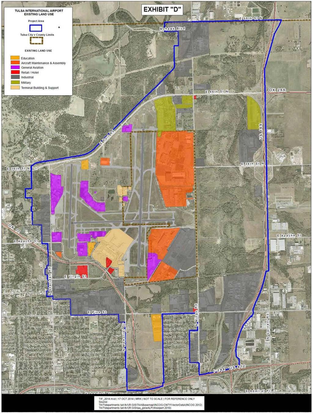
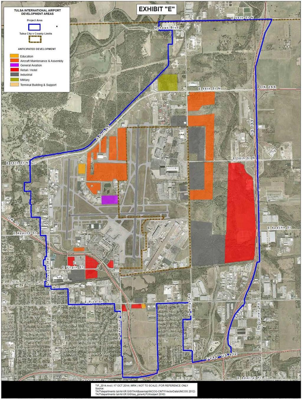
8 are not a part of the increment. Ad valorem taxing entities will experience additional revenues from increasing values near and adjacent to the Project. Incremental tax revenues are estimated to range between $500,000 annually in the near term and $5,000,000 annually over the longer term. The anticipated development will not result in a measurable increase in demand for services by or in costs to the affected taxing entities. The public revenue anticipated includes increased tax revenue both inside and outside the Increment Districts. The economic benefits of the Project Plan for the City, Tulsa County and the other affected taxing jurisdictions indicate positive financial impacts for the community as a whole. The aggregate impacts on the City and Tulsa County from implementation of the Project Plan are positive and include the achievement of the objectives set forth in Section IV. XI. FINANCING PLAN The proposed private developments will generate tax increments necessary to pay authorized public costs of the Project. XII. LAND USE Existing uses and conditions of real property in the Project Area are shown on the map attached as Exhibit D. The proposed improvements to and the proposed uses of the real property in the Project Area are shown on Exhibit E. XIII. MISCELLANEOUS PROVISIONS No changes in zoning are anticipated to be necessary to accommodate this Project. This Project Plan complies with the objectives and priorities of the Comprehensive Plan of the City of Tulsa, as amended, and the general objectives and priorities of Tulsa County. 7
9 EXHIBIT A: PROJECT AREA LEGAL DESCRIPTION A TRACT OF LAND BEING A PART OF SECTIONS 7, 8, 18, 19, 30, and 31 in Township 20 N., Range 14 E., TULSA COUNTY, OKLAHOMA, and SECTIONS 12, 13, 14, 15, 22, 23, 24, 25, 26, 27, 35 and 36 in TOWNSHIP 20 N., RANGE 13 E., TULSA COUNTY, OKLAHOMA, MORE PARTICULARLY DESCRIBED TO WIT: COMMENCING AT THE SOUTHWEST CORNER OF SECTION 26: THENCE EAST A DISTANCE OF 1, FEET TO THE POINT OF BEGINNING ; THENCE N E. A DISTANCE OF 3, FEET; THENCE S E. A DISTANCE OF FEET; THENCE S E. A DISTANCE OF FEET; THENCE S E. A DISTANCE OF FEET; THENCE S E. A DISTANCE OF FEET; THENCE S E. A DISTANCE OF FEET; THENCE S E. A DISTANCE OF FEET; THENCE S E. A DISTANCE OF FEET; THENCE S E. A DISTANCE OF FEET; THENCE N E. A DISTANCE OF FEET; THENCE N E. A DISTANCE OF FEET; THENCE N E. A DISTANCE OF FEET; THENCE N E. A DISTANCE OF FEET; THENCE N E. A DISTANCE OF FEET; THENCE N E. A DISTANCE OF FEET; THENCE S E. A DISTANCE OF FEET; THENCE S E. A DISTANCE OF FEET; THENCE S E. A DISTANCE OF FEET; THENCE S E. A DISTANCE OF FEET; THENCE S E. A DISTANCE OF FEET; THENCE S E. A DISTANCE OF FEET; THENCE S E. A DISTANCE OF FEET; THENCE S E. A DISTANCE OF FEET; THENCE S E. A DISTANCE OF FEET; THENCE S E. A DISTANCE OF FEET; THENCE S E. A DISTANCE OF FEET; THENCE S E. A DISTANCE OF FEET; THENCE S E. A DISTANCE OF FEET; THENCE S E. A DISTANCE OF FEET; THENCE S E. A DISTANCE OF FEET; THENCE S E. A DISTANCE OF FEET; THENCE S E. A DISTANCE OF FEET;
10 THENCE S E. A DISTANCE OF FEET; THENCE S E. A DISTANCE OF FEET; THENCE S E. A DISTANCE OF FEET; THENCE S E. A DISTANCE OF FEET; THENCE S E. A DISTANCE OF FEET; THENCE S E. A DISTANCE OF FEET; THENCE S E. A DISTANCE OF FEET; THENCE S E. A DISTANCE OF FEET; THENCE S E. A DISTANCE OF FEET; THENCE S E. A DISTANCE OF FEET; THENCE S E. A DISTANCE OF FEET; THENCE S E. A DISTANCE OF FEET; THENCE S E. A DISTANCE OF FEET; THENCE S E. A DISTANCE OF FEET; THENCE S E. A DISTANCE OF FEET; THENCE S E. A DISTANCE OF FEET; THENCE S E. A DISTANCE OF FEET; THENCE S E. A DISTANCE OF FEET; THENCE N E. A DISTANCE OF FEET; THENCE S E. A DISTANCE OF FEET; THENCE S E. A DISTANCE OF FEET; THENCE S E. A DISTANCE OF FEET; THENCE S E. A DISTANCE OF FEET; THENCE S E. A DISTANCE OF FEET; THENCE S E. A DISTANCE OF FEET; THENCE N E. A DISTANCE OF FEET; THENCE N E. A DISTANCE OF FEET; THENCE N E. A DISTANCE OF FEET; THENCE N E. A DISTANCE OF FEET; THENCE N E. A DISTANCE OF FEET; THENCE N E. A DISTANCE OF FEET; THENCE N E. A DISTANCE OF FEET; THENCE N E. A DISTANCE OF FEET; THENCE N E. A DISTANCE OF FEET; THENCE N E. A DISTANCE OF FEET; THENCE N W. A DISTANCE OF FEET; THENCE N E. A DISTANCE OF FEET; THENCE S E. A DISTANCE OF FEET; THENCE N W. A DISTANCE OF FEET; THENCE N W. A DISTANCE OF FEET; THENCE N W. A DISTANCE OF FEET; THENCE N W. A DISTANCE OF FEET; THENCE N W. A DISTANCE OF FEET; THENCE N W. A DISTANCE OF FEET; FINAL FOR ADOPTION
11 THENCE N W. A DISTANCE OF FEET; THENCE N W. A DISTANCE OF FEET; THENCE N W. A DISTANCE OF FEET; THENCE N W. A DISTANCE OF FEET; THENCE N W. A DISTANCE OF FEET; THENCE N W. A DISTANCE OF FEET; THENCE N W. A DISTANCE OF FEET; THENCE N W. A DISTANCE OF FEET; THENCE N W. A DISTANCE OF FEET; THENCE N W. A DISTANCE OF FEET; THENCE N W. A DISTANCE OF FEET; THENCE N W. A DISTANCE OF FEET; THENCE N W. A DISTANCE OF FEET; THENCE N W. A DISTANCE OF FEET; THENCE N E. A DISTANCE OF FEET; THENCE N E. A DISTANCE OF FEET; THENCE N W. A DISTANCE OF FEET; THENCE N W. A DISTANCE OF FEET; THENCE N W. A DISTANCE OF FEET; THENCE N E. A DISTANCE OF FEET; THENCE N W. A DISTANCE OF FEET; THENCE N W. A DISTANCE OF FEET; THENCE N W. A DISTANCE OF FEET; THENCE N W. A DISTANCE OF FEET; THENCE N W. A DISTANCE OF FEET; THENCE N W. A DISTANCE OF FEET; THENCE N W. A DISTANCE OF FEET; THENCE N E. A DISTANCE OF FEET; THENCE N W. A DISTANCE OF FEET; THENCE N W. A DISTANCE OF FEET; THENCE N W. A DISTANCE OF FEET; THENCE N W. A DISTANCE OF FEET; THENCE N W. A DISTANCE OF FEET; THENCE N W. A DISTANCE OF FEET; THENCE N W. A DISTANCE OF FEET; THENCE N W. A DISTANCE OF FEET; THENCE N W. A DISTANCE OF FEET; THENCE N W. A DISTANCE OF FEET; THENCE N W. A DISTANCE OF FEET; THENCE N W. A DISTANCE OF FEET; THENCE N W. A DISTANCE OF FEET; THENCE N W. A DISTANCE OF FEET; THENCE S E. A DISTANCE OF FEET; THENCE N E. A DISTANCE OF FEET; FINAL FOR ADOPTION
12 THENCE N E. A DISTANCE OF FEET; THENCE N E. A DISTANCE OF FEET; THENCE N E. A DISTANCE OF FEET; THENCE N E. A DISTANCE OF FEET; THENCE N E. A DISTANCE OF FEET; THENCE N E. A DISTANCE OF FEET; THENCE N E. A DISTANCE OF FEET; THENCE N E. A DISTANCE OF FEET; THENCE N E. A DISTANCE OF FEET; THENCE N E. A DISTANCE OF FEET; THENCE N E. A DISTANCE OF FEET; THENCE N E. A DISTANCE OF FEET; THENCE N E. A DISTANCE OF FEET; THENCE N E. A DISTANCE OF FEET; THENCE N E. A DISTANCE OF FEET; THENCE N E. A DISTANCE OF FEET; THENCE N E. A DISTANCE OF FEET; THENCE N E. A DISTANCE OF FEET; THENCE N E. A DISTANCE OF FEET; THENCE N E. A DISTANCE OF FEET; THENCE N E. A DISTANCE OF FEET; THENCE N E. A DISTANCE OF FEET; THENCE N E. A DISTANCE OF FEET; THENCE N E. A DISTANCE OF FEET; THENCE N E. A DISTANCE OF FEET; THENCE N E. A DISTANCE OF FEET; THENCE N E. A DISTANCE OF FEET; THENCE N E. A DISTANCE OF FEET; THENCE N E. A DISTANCE OF FEET; THENCE N E. A DISTANCE OF FEET; THENCE N E. A DISTANCE OF FEET; THENCE N E. A DISTANCE OF FEET; THENCE N E. A DISTANCE OF FEET; THENCE N E. A DISTANCE OF FEET; THENCE S E. A DISTANCE OF FEET; THENCE S E. A DISTANCE OF FEET; THENCE S E. A DISTANCE OF FEET; THENCE S W. A DISTANCE OF FEET; THENCE S E. A DISTANCE OF FEET; THENCE S E. A DISTANCE OF FEET; THENCE S E. A DISTANCE OF FEET; THENCE S W. A DISTANCE OF FEET; THENCE S E. A DISTANCE OF FEET; THENCE S E. A DISTANCE OF FEET; FINAL FOR ADOPTION
13 THENCE S E. A DISTANCE OF FEET; THENCE S E. A DISTANCE OF FEET; THENCE S W. A DISTANCE OF 6.14 FEET; THENCE S W. A DISTANCE OF FEET; THENCE S E. A DISTANCE OF FEET; THENCE S E. A DISTANCE OF FEET; THENCE N E. A DISTANCE OF FEET; THENCE S E. A DISTANCE OF FEET; THENCE N E. A DISTANCE OF FEET; THENCE S E. A DISTANCE OF FEET; THENCE N E. A DISTANCE OF 1, FEET; THENCE N E. A DISTANCE OF FEET; THENCE N E. A DISTANCE OF FEET; THENCE N W. A DISTANCE OF FEET; THENCE N E. A DISTANCE OF FEET; THENCE N W. A DISTANCE OF FEET; THENCE N W. A DISTANCE OF FEET; THENCE N W. A DISTANCE OF FEET; THENCE N W. A DISTANCE OF FEET; THENCE N E. A DISTANCE OF FEET; THENCE N E. A DISTANCE OF FEET; THENCE N E. A DISTANCE OF FEET; THENCE N E. A DISTANCE OF FEET; THENCE N E. A DISTANCE OF FEET; THENCE N W. A DISTANCE OF FEET; THENCE N E. A DISTANCE OF FEET; THENCE N E. A DISTANCE OF FEET; THENCE N E. A DISTANCE OF FEET; THENCE N E. A DISTANCE OF FEET; THENCE S E. A DISTANCE OF FEET; THENCE S E. A DISTANCE OF FEET; THENCE N E. A DISTANCE OF FEET; THENCE N W. A DISTANCE OF FEET; THENCE N E. A DISTANCE OF FEET; THENCE N E. A DISTANCE OF FEET; THENCE N E. A DISTANCE OF FEET; THENCE N E. A DISTANCE OF FEET; THENCE N E. A DISTANCE OF FEET; THENCE N E. A DISTANCE OF FEET; THENCE N E. A DISTANCE OF FEET; THENCE N E. A DISTANCE OF FEET; THENCE N E. A DISTANCE OF FEET; THENCE N E. A DISTANCE OF 6.14 FEET; THENCE N E. A DISTANCE OF FEET; FINAL FOR ADOPTION
14 THENCE N E. A DISTANCE OF FEET; THENCE N W. A DISTANCE OF FEET; THENCE N W. A DISTANCE OF FEET; THENCE N W. A DISTANCE OF FEET; THENCE N W. A DISTANCE OF FEET; THENCE N W. A DISTANCE OF FEET; THENCE N W. A DISTANCE OF 2, FEET; THENCE N W. A DISTANCE OF FEET; THENCE N W. A DISTANCE OF FEET; THENCE N W. A DISTANCE OF FEET; THENCE N W. A DISTANCE OF FEET; THENCE N W. A DISTANCE OF 1, FEET; THENCE N W. A DISTANCE OF FEET; THENCE N W. A DISTANCE OF FEET; THENCE N W. A DISTANCE OF FEET; THENCE N W. A DISTANCE OF FEET; THENCE N W. A DISTANCE OF FEET; THENCE N W. A DISTANCE OF 1, FEET; THENCE N W. A DISTANCE OF FEET; THENCE N W. A DISTANCE OF 1, FEET; THENCE N W. A DISTANCE OF 1, FEET; THENCE N W. A DISTANCE OF FEET; THENCE N E. A DISTANCE OF 1, FEET; THENCE N E. A DISTANCE OF FEET; THENCE N E. A DISTANCE OF 1, FEET; THENCE N E. A DISTANCE OF FEET; THENCE N E. A DISTANCE OF FEET; THENCE S W. A DISTANCE OF FEET; THENCE S W. A DISTANCE OF 3, FEET; THENCE S W. A DISTANCE OF FEET; THENCE S W. A DISTANCE OF FEET; THENCE S W. A DISTANCE OF FEET; THENCE S W. A DISTANCE OF FEET; THENCE S W. A DISTANCE OF FEET; THENCE S W. A DISTANCE OF FEET; THENCE S W. A DISTANCE OF FEET; THENCE S W. A DISTANCE OF FEET; THENCE S W. A DISTANCE OF FEET; THENCE S W. A DISTANCE OF FEET; THENCE S E. A DISTANCE OF FEET; THENCE N E. A DISTANCE OF FEET; THENCE S E. A DISTANCE OF 1, FEET; THENCE S W. A DISTANCE OF FEET; THENCE S E. A DISTANCE OF FEET; FINAL FOR ADOPTION
15 THENCE S E. A DISTANCE OF FEET; THENCE S E. A DISTANCE OF FEET; THENCE S E. A DISTANCE OF FEET; THENCE S E. A DISTANCE OF FEET; THENCE S W. A DISTANCE OF FEET; THENCE S W. A DISTANCE OF FEET; THENCE S W. A DISTANCE OF FEET; THENCE S W. A DISTANCE OF FEET; THENCE N W. A DISTANCE OF FEET; THENCE S W. A DISTANCE OF FEET; THENCE S W. A DISTANCE OF FEET; THENCE S W. A DISTANCE OF FEET; THENCE S W. A DISTANCE OF FEET; THENCE S W. A DISTANCE OF FEET; THENCE S W. A DISTANCE OF FEET; THENCE S W. A DISTANCE OF 1, FEET; THENCE S W. A DISTANCE OF FEET; THENCE S W. A DISTANCE OF FEET; THENCE S W. A DISTANCE OF FEET; THENCE S W. A DISTANCE OF 1, FEET; THENCE S W. A DISTANCE OF FEET; THENCE S W. A DISTANCE OF FEET; THENCE S W. A DISTANCE OF FEET; THENCE S W. A DISTANCE OF FEET; THENCE S W. A DISTANCE OF FEET; THENCE S W. A DISTANCE OF FEET; THENCE S W. A DISTANCE OF FEET; THENCE S W. A DISTANCE OF FEET; THENCE S W. A DISTANCE OF FEET; THENCE S W. A DISTANCE OF FEET; THENCE S W. A DISTANCE OF FEET; THENCE S W. A DISTANCE OF FEET; THENCE S W. A DISTANCE OF FEET; THENCE S W. A DISTANCE OF FEET; THENCE S W. A DISTANCE OF FEET; THENCE S W. A DISTANCE OF FEET; THENCE S W. A DISTANCE OF FEET; THENCE S W. A DISTANCE OF FEET; THENCE S W. A DISTANCE OF FEET; THENCE S W. A DISTANCE OF FEET; THENCE S W. A DISTANCE OF FEET; THENCE S W. A DISTANCE OF FEET; THENCE S W. A DISTANCE OF FEET; THENCE S W. A DISTANCE OF FEET; FINAL FOR ADOPTION
16 THENCE S W. A DISTANCE OF FEET; THENCE S W. A DISTANCE OF FEET; THENCE S W. A DISTANCE OF FEET; THENCE S W. A DISTANCE OF FEET; THENCE S W. A DISTANCE OF FEET; THENCE S W. A DISTANCE OF FEET; THENCE S W. A DISTANCE OF FEET; THENCE S W. A DISTANCE OF FEET; THENCE S W. A DISTANCE OF FEET; THENCE S W. A DISTANCE OF FEET; THENCE S W. A DISTANCE OF FEET; THENCE N W. A DISTANCE OF FEET; THENCE S W. A DISTANCE OF FEET; THENCE S E. A DISTANCE OF FEET; THENCE S W. A DISTANCE OF FEET; THENCE S W. A DISTANCE OF FEET; THENCE S E. A DISTANCE OF FEET; THENCE S E. A DISTANCE OF FEET; THENCE S W. A DISTANCE OF FEET; THENCE S E. A DISTANCE OF FEET; THENCE N E. A DISTANCE OF FEET; THENCE S E. A DISTANCE OF 1, FEET; THENCE S W. A DISTANCE OF FEET; THENCE S W. A DISTANCE OF FEET; THENCE S E. A DISTANCE OF FEET; THENCE N E. A DISTANCE OF FEET; THENCE S E. A DISTANCE OF FEET; THENCE S E. A DISTANCE OF FEET; THENCE S W. A DISTANCE OF FEET; THENCE S E. A DISTANCE OF FEET; THENCE N E. A DISTANCE OF FEET; THENCE S E. A DISTANCE OF FEET; THENCE S E. A DISTANCE OF FEET; THENCE S E. A DISTANCE OF FEET; THENCE S E. A DISTANCE OF FEET; THENCE N E. A DISTANCE OF FEET; THENCE S E. A DISTANCE OF FEET; THENCE S E. A DISTANCE OF FEET; THENCE S E. A DISTANCE OF FEET; THENCE S E. A DISTANCE OF FEET; THENCE S E. A DISTANCE OF FEET; THENCE S E. A DISTANCE OF FEET; THENCE S W. A DISTANCE OF FEET; THENCE S W. A DISTANCE OF FEET; FINAL FOR ADOPTION
17 THENCE S E. A DISTANCE OF FEET; THENCE S E. A DISTANCE OF FEET; THENCE S E. A DISTANCE OF FEET; THENCE S W. A DISTANCE OF 5.24 FEET; THENCE S E. A DISTANCE OF FEET; THENCE S E. A DISTANCE OF FEET; THENCE S E. A DISTANCE OF FEET; THENCE S E. A DISTANCE OF FEET; THENCE S E. A DISTANCE OF FEET; THENCE S E. A DISTANCE OF FEET; THENCE S E. A DISTANCE OF FEET; THENCE S E. A DISTANCE OF FEET; THENCE S E. A DISTANCE OF FEET; THENCE S E. A DISTANCE OF FEET; THENCE S E. A DISTANCE OF FEET; THENCE S E. A DISTANCE OF FEET; THENCE S W. A DISTANCE OF 37.78FEET; THENCE S E. A DISTANCE OF FEET; THENCE S E. A DISTANCE OF FEET; THENCE S E. A DISTANCE OF FEET; THENCE N E. A DISTANCE OF FEET; THENCE N E. A DISTANCE OF FEET; THENCE N E. A DISTANCE OF FEET; THENCE S E. A DISTANCE OF FEET; THENCE S E. A DISTANCE OF FEET; THENCE N E. A DISTANCE OF FEET; THENCE N E. A DISTANCE OF FEET; THENCE S E. A DISTANCE OF FEET; THENCE S E. A DISTANCE OF FEET; THENCE S E. A DISTANCE OF FEET; THENCE S E. A DISTANCE OF FEET; THENCE S E. A DISTANCE OF FEET; THENCE S E. A DISTANCE OF FEET; THENCE S E. A DISTANCE OF FEET; THENCE S E. A DISTANCE OF FEET; THENCE S E. A DISTANCE OF FEET; THENCE S E. A DISTANCE OF FEET; THENCE S E. A DISTANCE OF FEET; THENCE N E. A DISTANCE OF FEET; THENCE S E. A DISTANCE OF FEET; THENCE S W. A DISTANCE OF FEET; THENCE S W. A DISTANCE OF FEET; THENCE S E. A DISTANCE OF FEET; THENCE S E. A DISTANCE OF FEET; FINAL FOR ADOPTION
18 THENCE S E. A DISTANCE OF FEET; THENCE S E. A DISTANCE OF FEET; THENCE S W. A DISTANCE OF FEET; THENCE S E. A DISTANCE OF FEET; THENCE S E. A DISTANCE OF FEET; THENCE S E. A DISTANCE OF FEET; THENCE N E. A DISTANCE OF FEET; THENCE S E. A DISTANCE OF FEET; THENCE S E. A DISTANCE OF FEET; THENCE S E. A DISTANCE OF FEET; THENCE S E. A DISTANCE OF FEET; THENCE S E. A DISTANCE OF FEET; THENCE S E. A DISTANCE OF FEET; THENCE S E. A DISTANCE OF FEET; THENCE N E. A DISTANCE OF FEET; THENCE S E. A DISTANCE OF FEET; THENCE S E. A DISTANCE OF FEET; THENCE S E. A DISTANCE OF FEET; THENCE S E. A DISTANCE OF FEET; THENCE S E. A DISTANCE OF FEET; THENCE S E. A DISTANCE OF FEET; THENCE S E. A DISTANCE OF FEET; THENCE S E. A DISTANCE OF FEET; THENCE S E. A DISTANCE OF FEET; THENCE S E. A DISTANCE OF FEET; THENCE S E. A DISTANCE OF FEET; THENCE S E. A DISTANCE OF FEET; THENCE S E. A DISTANCE OF FEET; THENCE S W. A DISTANCE OF FEET; THENCE S W. A DISTANCE OF FEET; THENCE S W. A DISTANCE OF FEET; THENCE S E. A DISTANCE OF FEET; THENCE S E. A DISTANCE OF FEET; THENCE N E. A DISTANCE OF FEET; THENCE N E. A DISTANCE OF FEET; THENCE N E. A DISTANCE OF FEET; THENCE N E. A DISTANCE OF FEET; THENCE S E. A DISTANCE OF FEET; THENCE N E. A DISTANCE OF FEET; THENCE N E. A DISTANCE OF FEET; THENCE N E. A DISTANCE OF FEET; THENCE N E. A DISTANCE OF FEET; THENCE N E. A DISTANCE OF FEET; THENCE N E. A DISTANCE OF FEET; FINAL FOR ADOPTION
19 THENCE N E. A DISTANCE OF FEET; THENCE N E. A DISTANCE OF FEET; THENCE N E. A DISTANCE OF FEET; THENCE N E. A DISTANCE OF FEET; THENCE N E. A DISTANCE OF FEET; THENCE N E. A DISTANCE OF FEET; THENCE N E. A DISTANCE OF FEET; THENCE N E. A DISTANCE OF FEET; THENCE N E. A DISTANCE OF FEET; THENCE N E. A DISTANCE OF FEET; THENCE N E. A DISTANCE OF FEET; THENCE N E. A DISTANCE OF FEET; THENCE N E. A DISTANCE OF FEET; THENCE S E. A DISTANCE OF FEET; THENCE S E. A DISTANCE OF FEET; THENCE S E. A DISTANCE OF FEET; THENCE S E. A DISTANCE OF FEET; THENCE S E. A DISTANCE OF FEET; Back to the Point of Beginning Said area containing 301,498,360± sq. ft. or 6, ± ac. more or less.
20 EXHIBIT B: INCREMENT DISTRICT LEGAL DESCRIPTIONS DISTRICT A A TRACT OF LAND BEING A PART OF SECTIONS 13, 14, 23 and 24, TOWNSHIP 20 N., RANGE 13 E. TULSA COUNTY, OKLAHOMA, MORE PARTICULARLY DESCRIBED TO WIT: COMMENCING AT THE SOUTHWEST CORNER OF THE SOUTHWEST QUARTER OF SECTION 14: THENCE NORTH A DISTANCE OF FEET; THENCE EAST A DISTANCE OF 2, FEET TO THE "POINT OF BEGINNING"; THENCE S '48" E. A DISTANCE OF FEET; THENCE S '48" E. A DISTANCE OF FEET; THENCE N '00" W. A DISTANCE OF FEET; THENCE S '06" W. A DISTANCE OF FEET; THENCE S '47" W. A DISTANCE OF FEET; THENCE S '29" E. A DISTANCE OF FEET; THENCE S '18" E. A DISTANCE OF FEET; THENCE S '01" E. A DISTANCE OF FEET; THENCE N '49" E. A DISTANCE OF 1, FEET; THENCE N '43" E. A DISTANCE OF FEET; THENCE N '34" E. A DISTANCE OF FEET; THENCE N '26" E. A DISTANCE OF 1, FEET THENCE N '16" E. A DISTANCE OF FEET; THENCE N '51" E. A DISTANCE OF FEET; THENCE N '06" W. A DISTANCE OF FEET; THENCE N '43" W. A DISTANCE OF FEET; THENCE N '57" W. A DISTANCE OF 2, FEET; THENCE N '15" W. A DISTANCE OF FEET; THENCE N '14" E. A DISTANCE OF FEET; THENCE S '29" W. A DISTANCE OF FEET; THENCE S '27" W. A DISTANCE OF 1, FEET; THENCE S '24" W. A DISTANCE OF FEET; THENCE S '39" W. A DISTANCE OF FEET; THENCE S '57" W. A DISTANCE OF FEET; THENCE S '08" W. A DISTANCE OF FEET; THENCE S '30" W. A DISTANCE OF FEET; THENCE S '50" W. A DISTANCE OF FEET; THENCE S '49" W. A DISTANCE OF FEET; THENCE S '10" W. A DISTANCE OF FEET; THENCE S '24" E. A DISTANCE OF FEET;
21 THENCE S '45" W. A DISTANCE OF FEET; THENCE S '54.394" W. A DISTANCE OF FEET; BACK TO THE "POINT OF BEGINNING" SAID AREA CONTAINING 18,753,811± SQ. FT. OR ± AC. MORE OR LESS. DISTRICT B A TRACT OF LAND BEING A PART OF SECTIONS 13 and 24, TOWNSHIP 20 N, RANGE 13 E AND SECTIONS 18 and 19, TOWNSHIP 20 N, RANGE 14 E, TULSA COUNTY, OKLAHOMA, MORE PARTICULARLY DESCRIBED TO WIT: COMMENCING AT THE NORTHEAST CORNER OF SECTION 13: THENCE WEST A DISTANCE OF FEET; THENCE SOUTH A DISTANCE OF FEET TO THE "POINT OF BEGINNING"; THENCE S '25" W. A DISTANCE OF FEET; THENCE S '22" W. A DISTANCE OF FEET; THENCE S '48" W. A DISTANCE OF FEET; THENCE S '41" W. A DISTANCE OF FEET; THENCE S '52" W. A DISTANCE OF FEET; THENCE S '42" W. A DISTANCE OF FEET; THENCE S '42" W. A DISTANCE OF FEET; THENCE S '45" W. A DISTANCE OF FEET; THENCE N '24" W. A DISTANCE OF FEET; THENCE N '24" W. A DISTANCE OF FEET; THENCE ON A CURVE HAVING A CENTRAL ANGLE OF 22 37'58" A RADIUS OF 3, FEET AND AN ARC DISTANCE OF 1, FEET, SAID CURVE HAVING A CHORD BEARING OF S 76 0'44" W AND A CHORD DISTANCE OF 1, FEET; THENCE S '56" E. A DISTANCE OF FEET; THENCE S '16" E. A DISTANCE OF FEET THENCE S '25" E. A DISTANCE OF FEET; THENCE S '56" E. A DISTANCE OF FEET; THENCE S '49" W. A DISTANCE OF 1, FEET; THENCE N '05" E. A DISTANCE OF FEET; THENCE S '47" E. A DISTANCE OF FEET; THENCE S '28" W. A DISTANCE OF 2, FEET; THENCE S '17" E. A DISTANCE OF FEET; THENCE S '39" E. A DISTANCE OF FEET; THENCE S '30" E. A DISTANCE OF 1, FEET;
22 THENCE S '38" E. A DISTANCE OF FEET; THENCE N '10" E. A DISTANCE OF FEET; THENCE S '09" E. A DISTANCE OF FEET; THENCE N '28" E. A DISTANCE OF 3, FEET; THENCE N '08" E. A DISTANCE OF 3, FEET; THENCE N '46" E. A DISTANCE OF 2, FEET; THENCE N '03" E. A DISTANCE OF 2, FEET; THENCE S '09" W. A DISTANCE OF FEET; THENCE S '33" W. A DISTANCE OF FEET; THENCE S '11" W. A DISTANCE OF FEET; THENCE S '46" W. A DISTANCE OF FEET; THENCE S '22" W. A DISTANCE OF FEET; THENCE S '42" W. A DISTANCE OF FEET; THENCE S '54" W. A DISTANCE OF FEET; THENCE N '34" W. A DISTANCE OF 9.08 FEET; THENCE S '16" W. A DISTANCE OF FEET; THENCE S '56" W. A DISTANCE OF FEET; THENCE S '22" W. A DISTANCE OF FEET; THENCE N '20" W. A DISTANCE OF FEET; BACK TO THE "POINT OF BEGINNING" SAID AREA CONTAINING 39,383,287± SQ. FT. OR ± AC. MORE OR LESS. DISTRICT C LEGAL DESCRIPTION AIR FORCE PLANT NO. 3 A TRACT OF LAND IN SECTION 24 AND 25, OF TOWNSHIP 20 NORTH, RANGE 13 EAST OF THE INDIAN BASE AND MERIDIAN, TULSA COUNTY, STATE OF OKLAHOMA, BEING MORE PARTICULARLY DESCRIBED AS FOLLOWS, TO WIT: BEGINNING AT THE SOUTHEAST CORNER OF SAID SECTION 24 THENCE N 89 55' 17" W A DISTANCE OF FEET TO THE "POINT OF BEGINNING"; THENCE N 00 00' 42" E A DISTANCE OF FEET TOA POINT THENCE N 89 55' 17" W A DISTANCE OF FEET TO A POINT; THENCE N 52 50' 16" W A DISTANCE OF FEET TO A POINT; THENCE N 89 54' 59" W A DISTANCE OF FEET TO A POINT; THENCE S 50 43' 47" W A DISTANCE OF FEET TO A POINT; THENCE N 89 55' 17" W A DISTANCE OF 2, FEET TO A POINT; THENCE S 00 05' 57" E A DISTANCE OF FEET TO A POINT; THENCE S 34 12' 15" W A DISTANCE OF FEET TO A POINT; THENCE S 02 17' 54" W A DISTANCE OF 1, FEET TO A POINT;
23 THENCE N 89 52' 01" W A DISTANCE OF FEET TO A POINT; THENCE S 00 02' 45" W A DISTANCE OF 1, FEET TO A POINT; THENCE N 84 36' 22" E A DISTANCE OF 3, FEET TO A POINT; THENCE N 05 23' 38" W A DISTANCE OF FEET TO A POINT; THENCE N 84 36' 22" E A DISTANCE OF FEET TO A POINT; THENCE N 00 00' 42" E A DISTANCE OF 2, FEET TO THE "POINT OF BEGINNING"; CONTAINING 12,818,757 SQUARE FEET OR ACRES MORE OR LESS. DISTRICT D A TRACT OF LAND BEING A PART OF SECTIONS 23, 24, 25 AND 26, TOWNSHIP 20 N, RANGE 13 E, TULSA COUNTY, OKLAHOMA, MORE PARTICULARLY DESCRIBED TO WIT: COMMENCING AT THE SOUTHWEST CORNER OF SECTION 26: THENCE EAST A DISTANCE OF 1, FEET; TO THE "POINT OF BEGINNING" THENCE N '32" E. A DISTANCE OF 3, FEET; THENCE S '10" E. A DISTANCE OF FEET; THENCE S '59" E. A DISTANCE OF FEET; THENCE S '40" E. A DISTANCE OF FEET; THENCE S '53" E. A DISTANCE OF FEET; THENCE S '10" E. A DISTANCE OF FEET; THENCE S.01 16'29" E. A DISTANCE OF FEET; THENCE S '47" E. A DISTANCE OF FEET; THENCE S '12" E. A DISTANCE OF FEET; THENCE N '52" E. A DISTANCE OF FEET; THENCE N '44" E. A DISTANCE OF FEET THENCE N '30" E. A DISTANCE OF FEET; THENCE N '07" E. A DISTANCE OF FEET; THENCE N '36" E. A DISTANCE OF FEET; THENCE N '34" E. A DISTANCE OF FEET; THENCE N '22" E. A DISTANCE OF FEET; THENCE N '53" E. A DISTANCE OF FEET; THENCE S '43" E. A DISTANCE OF 1, FEET; THENCE N '34" E. A DISTANCE OF FEET; THENCE N '57" W. A DISTANCE OF FEET; THENCE N '10" E. A DISTANCE OF FEET; THENCE N '27" W. A DISTANCE OF FEET; THENCE N '02" E. A DISTANCE OF FEET;
24 THENCE N '54" E. A DISTANCE OF FEET; THENCE N '33" E. A DISTANCE OF FEET; THENCE N '16" W. A DISTANCE OF 9.87 FEET; THENCE N '51" E. A DISTANCE OF FEET; THENCE N '31" W. A DISTANCE OF 1, FEET; THENCE S '19" W. A DISTANCE OF FEET; THENCE N '20" W. A DISTANCE OF FEET; THENCE N W. A DISTANCE OF FEET; THENCE S W. A DISTANCE OF 1, FEET; THENCE S W. A DISTANCE OF 1, FEET; THENCE S E. A DISTANCE OF 1, FEET; THENCE S '21" E. A DISTANCE OF FEET; THENCE S '11" W. A DISTANCE OF FEET; THENCE S '13" E. A DISTANCE OF FEET; THENCE N '26" W. A DISTANCE OF 1, FEET; THENCE S '45" E. A DISTANCE OF FEET; THENCE S '44" W. A DISTANCE OF FEET; THENCE S '44" W. A DISTANCE OF FEET; THENCE N '17" W. A DISTANCE OF FEET; THENCE N '16" W. A DISTANCE OF FEET; THENCE N '35" W. A DISTANCE OF FEET; THENCE N '10" W. A DISTANCE OF FEET; THENCE N '49" W. A DISTANCE OF FEET; THENCE N '14" W. A DISTANCE OF FEET; THENCE N '07" W. A DISTANCE OF FEET; THENCE N '18" W. A DISTANCE OF 1, FEET; THENCE N '44" E. A DISTANCE OF FEET; THENCE N '39" E. A DISTANCE OF FEET; THENCE N '24" W. A DISTANCE OF FEET; THENCE N '49" W. A DISTANCE OF FEET; THENCE S '33" W. A DISTANCE OF FEET; THENCE S '22" W. A DISTANCE OF FEET; THENCE S '11" W. A DISTANCE OF 1, FEET; THENCE S '38" W. A DISTANCE OF FEET; THENCE S '42" W. A DISTANCE OF FEET; THENCE S '45" W. A DISTANCE OF FEET; THENCE S '04" W. A DISTANCE OF FEET; THENCE N '28" W. A DISTANCE OF FEET; THENCE N '48" W. A DISTANCE OF FEET; THENCE N '30" W. A DISTANCE OF FEET; THENCE N '40" W. A DISTANCE OF FEET; THENCE N '29" W. A DISTANCE OF FEET; THENCE N '03" W. A DISTANCE OF FEET; THENCE N '06" W. A DISTANCE OF FEET; FINAL FOR ADOPTION
25 THENCE N '37" W. A DISTANCE OF FEET; THENCE N '18" W. A DISTANCE OF FEET; THENCE N '30" W. A DISTANCE OF FEET; THENCE S '53" W. A DISTANCE OF FEET; THENCE S '31" W. A DISTANCE OF FEET; THENCE S '35" W. A DISTANCE OF FEET; THENCE N '50" W. A DISTANCE OF FEET; THENCE S '34" W. A DISTANCE OF FEET; THENCE S '58" W. A DISTANCE OF 9.66 FEET; THENCE S '07" W. A DISTANCE OF FEET; THENCE S '22" E. A DISTANCE OF FEET; THENCE S '13" E. A DISTANCE OF FEET; THENCE S '14" E. A DISTANCE OF FEET; THENCE S '29" E. A DISTANCE OF FEET; THENCE S '51" E. A DISTANCE OF FEET; THENCE S '13" E. A DISTANCE OF FEET; THENCE S '49" E. A DISTANCE OF FEET; THENCE S '19" E. A DISTANCE OF FEET; THENCE S '03" E. A DISTANCE OF FEET; THENCE S '03" E. A DISTANCE OF FEET; THENCE N '23" E. A DISTANCE OF FEET; THENCE S '45" E. A DISTANCE OF FEET; THENCE S '44" W. A DISTANCE OF FEET; THENCE S '32" E. A DISTANCE OF FEET; THENCE S '31" E. A DISTANCE OF FEET; THENCE S '45" W. A DISTANCE OF FEET; THENCE S '22" E. A DISTANCE OF FEET; THENCE N '25" E. A DISTANCE OF FEET; THENCE S '20" E. A DISTANCE OF FEET; THENCE N '36" E. A DISTANCE OF FEET; THENCE S '16" E. A DISTANCE OF FEET; THENCE S '13" E. A DISTANCE OF FEET; THENCE S '19" E. A DISTANCE OF FEET; THENCE S '24" E. A DISTANCE OF FEET; THENCE S '13" E. A DISTANCE OF FEET; THENCE S '12" E. A DISTANCE OF FEET; THENCE S '12" E. A DISTANCE OF FEET; THENCE S '13" E. A DISTANCE OF FEET; THENCE S '16" E. A DISTANCE OF FEET; THENCE S '56" E. A DISTANCE OF FEET; THENCE S '48" E. A DISTANCE OF FEET; THENCE S '58" E. A DISTANCE OF FEET; THENCE S '59" W. A DISTANCE OF FEET; THENCE S '34" W. A DISTANCE OF FEET; FINAL FOR ADOPTION
26 THENCE S '52" E. A DISTANCE OF FEET; THENCE S '53" E. A DISTANCE OF FEET; THENCE S '22" E. A DISTANCE OF FEET; THENCE N '14" E. A DISTANCE OF FEET; THENCE N '37" E. A DISTANCE OF FEET; THENCE N '15" E. A DISTANCE OF FEET; THENCE N '09" E. A DISTANCE OF FEET; THENCE N '43" E. A DISTANCE OF FEET; THENCE S '38" E. A DISTANCE OF FEET; THENCE N '39" E. A DISTANCE OF FEET; THENCE N '36" E. A DISTANCE OF FEET; THENCE N '23" E. A DISTANCE OF FEET; THENCE N '09" E. A DISTANCE OF FEET; THENCE N '58" E. A DISTANCE OF FEET; THENCE N '44" E. A DISTANCE OF FEET; THENCE N '17" E. A DISTANCE OF FEET; THENCE N '25" E. A DISTANCE OF 8.74 FEET; THENCE N '21" E. A DISTANCE OF FEET; THENCE N '11" E. A DISTANCE OF FEET; THENCE N '01" E. A DISTANCE OF FEET; THENCE N '53" E. A DISTANCE OF FEET; THENCE N '44" E. A DISTANCE OF FEET; THENCE N '38" E. A DISTANCE OF FEET; THENCE N '31" E. A DISTANCE OF FEET; THENCE N '26" E. A DISTANCE OF FEET; THENCE N '21" E. A DISTANCE OF FEET; THENCE N '17" E. A DISTANCE OF FEET; THENCE N '40" E. A DISTANCE OF FEET; THENCE S '54" E. A DISTANCE OF FEET; THENCE S '01" E. A DISTANCE OF FEET; THENCE S '53" E. A DISTANCE OF FEET; THENCE S '31" E. A DISTANCE OF FEET; THENCE S '01" E. A DISTANCE OF FEET; THENCE S ' " E. A DISTANCE OF FEET; BACK TO THE "POINT OF BEGINNING" SAID AREA CONTAINING 37,953,814 ± SQ. FT. OR ± AC. MORE OR LESS. DISTRICT E A TRACT OF LAND BEING A PART OF SECTION 18,TOWNSHIP 20 N, RANGE 14 E, TULSA COUNTY, OKLAHOMA, MORE PARTICULARLY DESCRIBED TO WIT:
27 COMMENCING AT THE SOUTHWEST CORNER OF THE SOUTHEAST QUARTER OF SECTION 18: THENCE EAST A DISTANCE OF FEET; THENCE NORTH A DISTANCE OF FEET; TO THE "POINT OF BEGINNING" THENCE N '57" E. A DISTANCE OF 3, FEET; THENCE S '01" W. A DISTANCE OF FEET; THENCE N '51" E. A DISTANCE OF 1, FEET; THENCE S '16" E. A DISTANCE OF FEET; THENCE N '48" E. A DISTANCE OF FEET; THENCE N '12" W. A DISTANCE OF FEET; THENCE N '49" E. A DISTANCE OF FEET; THENCE S '40" E. A DISTANCE OF FEET; THENCE S '02" E. A DISTANCE OF FEET; THENCE S '26" E. A DISTANCE OF FEET; THENCE S '05" E. A DISTANCE OF FEET; THENCE S '38" E. A DISTANCE OF FEET; THENCE S '42" W. A DISTANCE OF FEET; THENCE S '57" W. A DISTANCE OF 1, FEET; THENCE S '10" W. A DISTANCE OF FEET; THENCE S '24" W. A DISTANCE OF FEET; THENCE S '05" E. A DISTANCE OF FEET; THENCE N '52" E. A DISTANCE OF FEET; THENCE S.01 55'40" W. A DISTANCE OF FEET; THENCE N '37" E. A DISTANCE OF 1, FEET; THENCE S '22" E. A DISTANCE OF FEET; THENCE S '53" W. A DISTANCE OF FEET; THENCE ON A CURVE HAVING A CENTRAL ANGLE OF 43 06'58" A RADIUS OF FEET AND AN ARC DISTANCE OF FEET, SAID CURVE HAVING A CHORD BEARING OF S.18 16'32" W. AND A CHORD DISTANCE OF FEET; THENCE S '27" E. A DISTANCE OF FEET; THENCE S '14" W. A DISTANCE OF FEET; THENCE S '25" W. A DISTANCE OF 1, FEET;BACK TO THE "POINT OF BEGINNING" SAID AREA CONTAINING 5,993,748.± SQ. FT. OR ± AC. MORE OR LESS. A TRACT OF LAND BEING A PART OF SECTIONS 19 AND 30,TOWNSHIP 20 N, RANGE 14 E, TULSA COUNTY, OKLAHOMA, MORE PARTICULARLY DESCRIBED TO WIT: COMMENCING AT THE SOUTHWEST CORNER OF THE NORTHWEST QUARTER OF SECTION 30: THENCE N '14" E. A DISTANCE OF FEET; THENCE N '57" W A DISTANCE OF FEET TO THE "POINT OF BEGINNING";
28 THENCE N '55" E. A DISTANCE OF 1, FEET; THENCE N '30" E. A DISTANCE OF 1, FEET; THENCE N '50" E. A DISTANCE OF 1, FEET; THENCE N '48" E. A DISTANCE OF FEET; THENCE S '56" E. A DISTANCE OF FEET; THENCE STARTING ANGLE OF N 82 39'26" W AND AN ENDING ANGLE OF S 88 51'24" W A CURVE HAVING A CENTRAL ANGLE OF 8 29'11" A RADIUS OF 8, FEET AND AN ARC DISTANCE OF 1, FEET, SAID CURVE HAVING A CHORD BEARING OF N 03 05'59" E AND A CHORD DISTANCE OF 1, FEET; THENCE S '07" E. A DISTANCE OF FEET; THENCE N '53" W. A DISTANCE OF FEET; THENCE S '35" W. A DISTANCE OF FEET; THENCE N '53" W. A DISTANCE OF FEET; THENCE N '36" W. A DISTANCE OF FEET; THENCE N '53" E. A DISTANCE OF 1, FEET; THENCE N '49" W. A DISTANCE OF 1, FEET; THENCE STARTING ANGLE OF S 36 19'14" W AND AN ENDING ANGLE OF S 87 42'22" W A CURVE HAVING A CENTRAL ANGLE OF 51 23'08" A RADIUS OF 325 FEET AND AN ARC DISTANCE OF FEET; SAID CURVE HAVING A CHORD BEARING OF N 27 59'12" W AND A CHORD DISTANCE OF FEET; THENCE N '18" W. A DISTANCE OF FEET; THENCE N '46" W. A DISTANCE OF FEET; THENCE N '37" W. A DISTANCE OF FEET; THENCE N '56" W. A DISTANCE OF FEET; THENCE S '21" W. A DISTANCE OF FEET; THENCE S '25" W. A DISTANCE OF 5, FEET; THENCE S '40" E. A DISTANCE OF FEET; THENCE N '46" W. A DISTANCE OF 1, FEET; THENCE N '18" W. A DISTANCE OF FEET; THENCE N.00 00'00" E. A DISTANCE OF FEET; THENCE N '22" W. A DISTANCE OF 1, FEET; THENCE S '11" E. A DISTANCE OF FEET; THENCE S '35" E. A DISTANCE OF FEET; THENCE S '21" E. A DISTANCE OF 1, FEET; THENCE S '39" W. A DISTANCE OF 5.00 FEET; THENCE S '53" E. A DISTANCE OF 1, FEET; THENCE S '51" E. A DISTANCE OF FEET;BACK TO THE "POINT OF BEGINNING" SAID AREA CONTAINING 20,993,898.± SQ. FT. OR ± AC. MORE OR LESS.
29
30
31
APPROVED BY REVIEW COMMITTEE April 13, 2015
 APPROVED BY REVIEW COMMITTEE April 13, 2015 CARLTON LANDING ECONOMIC DEVELOPMENT PROJECT PLAN PREPARED BY: THE TOWN OF CARLTON LANDING, OKLAHOMA JOANNE CHINNICI, MAYOR JEFF CLICK, TOWN TRUSTEE RICHARD
ORDINANCE NO AN ORDINANCE MAKING CERTAIN FINDINGS AND ESTABLISHING THE MALL REDEVELOPMENT DISTRICT
 Introduced: January 20, 2015 Passed: January 20, 2015 Published: January 23, 2015 ORDINANCE NO. 2015-2 AN ORDINANCE MAKING CERTAIN FINDINGS AND ESTABLISHING THE MALL REDEVELOPMENT DISTRICT WHEREAS, K.S.A.
FIRST AMENDMENT TO METRO NORTH CROSSING TAX INCREMENT FINANCING PLAN
 FIRST AMENDMENT TO METRO NORTH CROSSING TAX INCREMENT FINANCING PLAN KANSAS CITY, MISSOURI TIF COMMISSION APPROVAL: 12/13/17 12-2-17 DATE RESOLUTION NO. CITY COUNCIL APPROVAL: 2/1/18 180020 DATE ORDINANCE
ORDINANCE NO. SB-3131
 ORDINANCE NO. SB-3131 AN ORDINANCE MAKING FINDINGS AND ESTABLISHING A STAR BOND PROJECT DISTRICT WITHIN THE CITY OF OVERLAND PARK, KANSAS PURSUANT TO K.S.A. 12-17,160 ET SEQ., AS AMENDED (BLUHAWK STAR
CANADA PROVINCE OF BRITISH COLUMBIA
 Note: This supplementary Letters Patent has been consolidated from the Supplementary Letters Patents of the three Regional Districts of the Okanagan valley: North Okanagan Regional District; Central Okanagan
Session of HOUSE BILL No By Committee on Commerce, Labor and Economic Development 2-12
 Session of 0 HOUSE BILL No. 0 By Committee on Commerce, Labor and Economic Development - 0 0 0 AN ACT concerning the Kansas expanded lottery act; relating to racetrack gaming facilities; relating to parimutuel
Administration Report Fiscal Year 2011/2012
 Administration Report Fiscal Year 2011/2012 Poway Unified School District Community Facilities District No. 3 June 20, 2011 Prepared For: Poway Unified School District Planning Department 13626 Twin Peaks
Administration Report Fiscal Year 2010/2011
 Administration Report Fiscal Year 2010/2011 Poway Unified School District Community Facilities District No. 3 June 21, 2010 Prepared For: Poway Unified School District 13626 Twin Peaks Road Poway, CA 92064
CB TO AUTHORIZE THE CHIEF TO PLACE PROPERTY IN BRYAN COUNTY IN TRUST STATUS WITH THE UNITED STATES OF AMERICA
 CB- 141-16 TO AUTHORIZE THE CHIEF TO PLACE PROPERTY IN BRYAN COUNTY IN TRUST STATUS WITH THE UNITED STATES OF AMERICA IN THE TRIBAL COUNCIL OF THE CHOCTAW NATION ANTHONY DILLARD INTRODUCED THE FOLLOWING
City Council Meeting 8. B. Meeting Date: 09/08/2015. Agenda Category: New Business. Subject: Establishment of a STAR Bond Project District
 City Council Meeting 8. B. Meeting Date: 09/08/2015 Submitted By: Kathy Sexton, City Manager Agenda Category: New Business Subject: Establishment of a STAR Bond Project District Guests: Korb Maxwell, Attorney,
DALLAS MIDTOWN REDEVELOPMENT PLAN FOCUS NORTH TEXAS Peer Chacko, AICP, Assistant Director, City of Dallas
 DALLAS MIDTOWN REDEVELOPMENT PLAN FOCUS NORTH TEXAS 2014 Peer Chacko, AICP, Assistant Director, City of Dallas Dallas Midtown: Strategic growth area Future transit node 2 Peterson Road Study Area Galleria
Southwest Power Pool REGIONAL STATE COMMITTEE BYLAWS
 Southwest Power Pool REGIONAL STATE COMMITTEE BYLAWS Approved: October 30, 2017 ARTICLE I 1. NAME: The organization shall be known as the Southwest Power Pool Regional State Committee ( SPP RSC ). The
ORDINANCE NO CITY OF MONTICELLO ADOPTING TAX INCREMENT FINANCING TAX INCREMENT FINANCING DISTRICT II
 ORDINANCE NO. 2006-59 CITY OF MONTICELLO ADOPTING TAX INCREMENT FINANCING TAX INCREMENT FINANCING DISTRICT II WHEREAS, the City of Monticello, Illinois, desires to adopt tax increment financing pursuant
STATE OF NEW JERSEY. ASSEMBLY, No ASSEMBLY BUDGET COMMITTEE STATEMENT TO. with committee amendments DATED: DECEMBER 15, 2014
 ASSEMBLY BUDGET COMMITTEE STATEMENT TO ASSEMBLY, No. 3969 with committee amendments STATE OF NEW JERSEY DATED: DECEMBER 15, 2014 The Assembly Budget Committee reports favorably Assembly Bill No. 3969,
Enabling Legislation New York Thoroughbred Breeding and Development Fund
 Enabling Legislation New York Thoroughbred Breeding and Development Fund Racing, Pari-Mutuel Wagering and Breeding Law 252. New York state thoroughbred breeding and development fund. 1. A corporation to
ORDINANCE NO. ASMT-3189
 ORDINANCE NO. ASMT-3189 AN ORDINANCE LEVYING ASSESSMENTS ON LOTS, PIECES AND PARCELS OF GROUND FOR THE PURPOSE OF PAYING THE COST FOR THE CONSTRUCTION OF A FLOOD CONTROL PROJECT ALONG NEGRO CREEK BETWEEN
City of Chicago O Office of the City Clerk. Document Tracking Sheet
 City of Chicago Office of the City Clerk O2019-2185 Document Tracking Sheet Meeting Date: Sponsor(s): Type: Title: Committee(s) Assignment: 3/13/2019 Emanuel (Mayor) Ordinance Adoption of Tax Increment
RESOLUTION OF ADVISABILITY AND AUTHORIZATION NO. 7841
 1 2 3 4 5 6 7 8 9 10 11 12 13 14 15 16 17 18 19 20 21 22 23 24 25 26 27 28 29 30 31 32 33 34 35 (Published in the Topeka Metro News August 9, 2006) RESOLUTION OF ADVISABILITY AND AUTHORIZATION NO. 7841
BOARD OF ALDERMEN AGENDA
 NOTICE OF MEETING CITY OF BRANSON BOARD OF ALDERMEN Special Meeting Thursday, March 10, 2016 5:00 p.m. Council Chambers Branson City Hall 110 W. Maddux Meeting Called to Order Roll Call AGENDA REGULAR:
CITY OF GAYLORD RESOLUTION NUMBER TOWN OF DRYDEN SIBLEY COUNTY, MINNESOTA CITY OF GAYLORD SIBLEY COUNTY, MINNESOTA
 CTY OF GAYLORD RESOLUTON NUMBER TOWN OF DRYDEN SBLEY COUNTY, MNNESOTA CTY OF GAYLORD SBLEY COUNTY, MNNESOTA N THE MATTER OF THE ORDERLY ANNEXATON BETWEEN THE CTY OF GAYLORD DRYDEN TOWNSHP PURSUANT TO MNNESOTA
TORONTO MUNICIPAL CODE CHAPTER 30, DEBENTURE AND OTHER BORROWING. Chapter 30 DEBENTURE AND OTHER BORROWING. ARTICLE I General
 30-1. Definitions. TORONTO MUNICIPAL CODE 30-2. Delegation and annual limit. 30-3. Additional Agreements. 30-4. Variable interest rate. 30-5. Application to regulatory bodies. 30-6. Debenture Committee.
Tulsa Metropolitan Area LONG RANGE TRANSPORTATION PLAN
 Tulsa Metropolitan Area LONG RANGE TRANSPORTATION PLAN Indian Nations Council of Governments August 2005 CONTACTING INCOG In developing the Destination 2030 Long Range Transportation Plan, INCOG s Transportation
Exhibit 1 PLANNING COMMISSION AGENDA ITEM
 Exhibit 1 PLANNING COMMISSION AGENDA ITEM Project Name: Grand Junction Circulation Plan Grand Junction Complete Streets Policy Applicant: City of Grand Junction Representative: David Thornton Address:
CITY OF BLOOMINGTON COMPLETE STREETS POLICY
 CITY OF BLOOMINGTON COMPLETE STREETS POLICY POLICY OBJECTIVE: The City of Bloomington will enhance safety, mobility, accessibility and convenience for transportation network users of all ages and abilities,
CITY OF VAUGHAN EXTRACT FROM COUNCIL MEETING MINUTES OF OCTOBER 30, 2012
 CITY OF VAUGHAN EXTRACT FROM COUNCIL MEETING MINUTES OF OCTOBER 30, 2012 Item 31, Report No. 39, of the Committee of the Whole, which was adopted without amendment by the Council of the City of Vaughan
A G E N D A OKLAHOMA COUNTY PLANNING COMMISSION. November 16, Approval of Minutes of the Previous Meeting: (October 19, 2006)
") A G E N D A OKLAHOMA COUNTY PLANNING COMMISSION ROOM 103 1:30 p.m. November 16, 2006 1. Notice of meeting posted November 9, 2006. 2. Call to Order. 3. Roll Call. 4. Approval of Minutes of the Previous
A G E N D A OKLAHOMA COUNTY PLANNING COMMISSION ROOM 103 1:30 p.m. November 16, 2006 1. Notice of meeting posted November 9, 2006. 2. Call to Order. 3. Roll Call. 4. Approval of Minutes of the Previous
APPROVE A RESOLUTION ADOPTING A COMPLETE STREETS POLICY
 STAFF REPORT MEETING DATE: September 13, 2016 TO: FROM: City Council Bob Brown, Community Development Director Russ Thompson, Public Works Director Patrick Filipelli, Management Analyst 922 Machin Avenue
GOVERNMENT OF SASKATCHEWAN SUBMISSION TO THE RAILWAY SAFETY ACT REVIEW PANEL
 GOVERNMENT OF SASKATCHEWAN SUBMISSION TO THE RAILWAY SAFETY ACT REVIEW PANEL Saskatchewan Highways & Transportation May 29, 2007 I Introduction Government of Saskatchewan Submission To the Railway Safety
Americans with Disabilities Act Transition Plan for Public Right-of-Way Improvements
 Americans with Disabilities Act Transition Plan for Public Right-of-Way Improvements Prepared by: Public Works Department Engineering Division October 2015 Table of Contents Section I Introduction.. 3
COUNCIL COMMUNICATION
 Meeting Date: March 20, 2018 COUNCIL COMMUNICATION Agenda Item: Agenda Location: Action Items Work Plan # Legal Review: 1 st Reading 2 nd Reading Subject: A resolution approving the final design for the
1/9/2018. City Council City Hall Wilmington, North Carolina Dear Mayor and Councilmembers:
 ITEM O2 OFFICE OF THE CITY MANAGER (910) 341-7810 FAX (910)341-5839 TDD (910)341-7873 1/9/2018 City Council City Hall Wilmington, North Carolina 28401 Dear Mayor and Councilmembers: On March 21, 2017,
OHRIA Ontario Horse Racing Industry Association
 OHRIA Ontario Horse Racing Industry Association P.O. Box 456, Stn. B, Toronto, ON M9W 5L4 Tel: 416-679-0741 Fax: 416-679-9114 Email: ohria@ohria.com Submission to the Standing Committee of Finance and
Session of SENATE BILL No By Committee on Federal and State Affairs 2-21
 Session of SENATE BILL No. By Committee on Federal and State Affairs - 0 0 AN ACT concerning gaming; relating to the Kansas expanded lottery act; making and concerning appropriations for the fiscal year
CHAPTER House Bill No. 1509
 CHAPTER 2006-358 House Bill No. 1509 An act relating to Flagler Estates Road and Water Control District, St. Johns County; amending chapter 98-529, Laws of Florida; providing additional powers of the district
Adrian J Tidbury - Estates and Valuation Surveyor Portfolio Development
 18th September 2017 Community, Health & Housing Committee Courage Playing Fields Report of: Wards Affected: This report is: Adrian J Tidbury - Estates and Valuation Surveyor Portfolio Development Shenfield
when the following proceedings, among others were held and done, to-wit:
 STATE OF COLORADO ) COUNTY OF ADAMS ) At a regular meeting of the Board of County Commissioners for Adams County, Colorado, held at the Administration Building in Brighton, Colorado on the 22 nd day of
DANE COUNTY ORDINANCE AMENDMENT NO: Internal Tracking Number: RECU25760
 DANE COUNTY ORDINANCE AMENDMENT NO: 10246 Internal Tracking Number: RECU25760 Amending Section 10.03 relating to Zoning Districts in the Town of Vienna. The Dane County Board of Supervisors does ordain
Transportation Master Plan Advisory Task Force
 Transportation Master Plan Advisory Task Force Network Alternatives & Phasing Strategy February 2016 BACKGROUND Table of Contents BACKGROUND Purpose & Introduction 2 Linking the TMP to Key Council Approved
Capital and Strategic Planning Committee. Item III - B. April 12, WMATA s Transit-Oriented Development Objectives
 Capital and Strategic Planning Committee Item III - B April 12, 2018 WMATA s Transit-Oriented Development Objectives Page 24 of 76 Washington Metropolitan Area Transit Authority Board Action/Information
IMPLEMENTATION STRATEGIES
 GEORGETOWN SIDEWALK MASTER PLAN 34% of funding is dedicated to Downtown Overlay District sidewalks 28% of funding is recommended within 1/4 mile of Southwestern University 26% of funding is recommended
Arthrex, Inc Creekside Boulevard Naples FL Creekside Commerce Park CPUD
 Arthrex, Inc. 1370 Creekside Boulevard Naples FL 34108 239.403.6804 dgenson@barroncollier.com 27 48S 25E Please see Exhibit 2 Please see Exhibit 3 X X Please see Exhibit 5 Exhibit 2 Legal Description
Private-Public Partnership. Presentation to Metropolitan Council October 2, 2017
 Private-Public Partnership Presentation to Metropolitan Council October 2, 2017 THE FAIRGROUNDS NASHVILLE 160 unique events annually drawing more than 1.4 million attendees Christmas Village 2 FAIRGROUNDS
Basalt Creek Transportation Refinement Plan Recommendations
 Basalt Creek Transportation Refinement Plan Recommendations Introduction The Basalt Creek transportation planning effort analyzed future transportation conditions and evaluated alternative strategies for
STATE OF NEW YORK OFFICE OF THE STATE COMPTROLLER 110 STATE STREET ALBANY, NEW YORK September 2015
 THOMAS P. DiNAPOLI COMPTROLLER STATE OF NEW YORK OFFICE OF THE STATE COMPTROLLER 110 STATE STREET ALBANY, NEW YORK 12236 GABRIEL F. DEYO DEPUTY COMPTROLLER DIVISION OF LOCAL GOVERNMENT AND SCHOOL ACCOUNTABILITY
RESOLUTION NO ?? A RESOLUTION OF THE CITY OF NEPTUNE BEACH ADOPTING A COMPLETE STREETS POLICY
 RESOLUTION NO. 2018-?? A RESOLUTION OF THE CITY OF NEPTUNE BEACH ADOPTING A COMPLETE STREETS POLICY WHEREAS, safe, convenient, and accessible transportation for all users is a priority of the City of Neptune
ST. JOHNS GOLF CLUB PHASE II FINDINGS, PHASE III RECOMMENDATION, AND POTENTIAL PARTNERSHIP OPPORTUNITY
 ST. JOHNS GOLF CLUB PHASE II FINDINGS, PHASE III RECOMMENDATION, AND POTENTIAL PARTNERSHIP OPPORTUNITY Board of County Commissioners January 16, 2018 Introduction St. Johns Golf Club: Opened in 1989.
City of East Moline Committee of the Whole
 City of East Moline Committee of the Whole City Council Chambers 915 16 th Avenue East Moline, IL 61244 DATE: Monday, May 5 th, 2014 TIME: Immediately Following the Regular Council Meeting 1 Enterprise
Additional Policies & Objectives for Local Area Plans Ashbourne LAP. Ashbourne
 Ashbourne Strategic Policies SP 1 To operate an Order of Priority for the release of residential lands in compliance with the requirements of CS OBJ 6 of the County Development Plan as follows: i) The
ORDINANCE NO AMENDMENT TO ORDINANCE NO NASSAU COUNTY, norida. WHEREAS, on the 28th day of January, 1991, the Board of County
 ORDINANCE NO. 99-23 AMENDMENT TO ORDINANCE NO. 91-04 NASSAU COUNTY, norida WHEREAS, on the 28th day of January, 1991, the Board of County Commissioners, Nassau County, Florida (the "Board"), did adopt
Department of Legislative Services 2012 Session
 Department of Legislative Services 2012 Session HB 416 FISCAL AND POLICY NOTE House Bill 416 Ways and Means (Allegany County Delegation and Garrett County Delegation) Allegany and Garrett Counties - Slot
STATE OF NEW YORK OFFICE OF THE STATE COMPTROLLER 110 STATE STREET ALBANY, NEW YORK September 2015
 THOMAS P. DiNAPOLI COMPTROLLER STATE OF NEW YORK OFFICE OF THE STATE COMPTROLLER 110 STATE STREET ALBANY, NEW YORK 12236 GABRIEL F. DEYO DEPUTY COMPTROLLER DIVISION OF LOCAL GOVERNMENT AND SCHOOL ACCOUNTABILITY
INTERNATIONAL SKATING UNION
 INTERNATIONAL SKATING UNION Communication No. 2075 Applications for ISU Championships I. Applications for the following ISU Championships season 2019/20: ISU Members are invited to submit applications
TRANSPORTATION & INDUSTRIAL ACCESS STUDY PHASE II GENESEE TRANSPORTATION COUNCIL
 TRANSPORTATION & INDUSTRIAL ACCESS STUDY PHASE II GENESEE TRANSPORTATION COUNCIL MONROE COUNTY VILLAGE SQUARE FINAL CONCEPT-LEVEL STRATEGY REPORT I. Introduction The purpose of this report is to recommend
May 23, 2018 Proposed No.:
 1 May 23, 2018 Proposed No.: 18-004 2 3 4 5 6 7 8 9 10 11 12 13 14 15 16 17 18 19 20 21 22 23 24 25 26 27 28 RESOLUTION NO. A RESOLUTION of the Board of Directors of the Washington State Major League Baseball
ECONOMIC DEVELOPMENT ELEMENT
 ECONOMIC DEVELOPMENT ELEMENT Background The Economic Development Element considers labor force and labor force characteristics, employment by place of work and residence, and analysis of the community
RESOLUTION NO A RESOLUTION OF THE CITY COUNCIL OF THE CITY OF MENLO PARK ADOPTING A COMPLETE STREETS POLICY
 RESOLUTION NO. 6123 A RESOLUTION OF THE CITY COUNCIL OF THE CITY OF MENLO PARK ADOPTING A COMPLETE STREETS POLICY WHEREAS, the term Complete Streets describes a comprehensive, integrated transportation
110 Edgar Martinez Drive South P.O. Box Seattle, WA (206) August 15, 2018
 August 15, 2018") WASHINGTON STATE MAJOR LEAGUE BASEBALL STADIUM PUBLIC FACILITIES DISTRICT 110 Edgar Martinez Drive South P.O. Box 94445 Seattle, WA 98124 (206) 664-3076 www.ballpark.org Metropolitan King County Council
WASHINGTON STATE MAJOR LEAGUE BASEBALL STADIUM PUBLIC FACILITIES DISTRICT 110 Edgar Martinez Drive South P.O. Box 94445 Seattle, WA 98124 (206) 664-3076 www.ballpark.org Metropolitan King County Council
Planning & Zoning Commission
 Preliminary Plat Westwood, Section 3 Planning & Zoning Commission Planning & Development Department March 21, 2016 Request Subdivide approximately 38.1 acres of previously unplatted property to create
The following words and terms, when used in this rule, have the following meanings, unless the context clearly
 53ER13-47 MEGA MILLIONS. (1) Definitions. The following words and terms, when used in this rule, have the following meanings, unless the context clearly indicates otherwise: (a) Annuity prize A Jackpot
ORDINANCE ORDINANCE ANNEXING PROPERTY TSM GREENBRIER LLC
 ORDINANCE 2018-7 ORDINANCE ANNEXING PROPERTY TSM GREENBRIER LLC RECITALS WHEREAS, the City ofbuffalo has received a Petition for Annexation by Ordinance from TSM Greenbrier LLC for the annexation of97
QUIT-CLAIM DEED. STONE CLIFF, LC, a Utah limited liability company, and TRAVELLER/STONE CLIFF,
 Recorded at Request of: Stone Cliff Owners Association c/o John D. Richards III Richards Kimble & Winn, PC 2040 E. Murray-Holladay Rd., Suite 102 Salt Lake City, UT 84117 Mail tax notice to: Stone Cliff
MEMORANDUM OF LEASE RECITALS
 MEMORANDUM OF LEASE THE STATE OF TEXAS COUNTY OF HARRIS THIS MEMORANDUM OF LEASE (this "Memorandum") is made and entered into effective as of the 17th day of May, 2001, by and between HARRIS COUNTY SPORTS
116TH STREET AND BROOKS SCHOOL ROAD ORDINANCE NO B
 116TH STREET AND BROOKS SCHOOL ROAD ORDINANCE NO. 031802B A Text Amendment to Ordinance No. 071000A - An Ordinance Establishing the 116th Street and Brooks School Road Planned Unit Development District
Standing Committee on Policy and Strategic Priorities. Mount Pleasant Industrial Area Parking Strategy and Access Improvements
 POLICY REPORT Report Date: April 23, 2018 Contact: Lon LaClaire Contact No.: 604.873.7722 RTS No.: 9944 VanRIMS No.: 08-2000-20 Meeting Date: May 16, 2018 TO: FROM: SUBJECT: Standing Committee on Policy
Strategies to Promote the Availability of Affordable Healthy Food and Beverages
 Strategies to Promote the Availability of Affordable Healthy Food and Beverages CDC Recommended Strategies and Measurements Strategy #1: Communities Should Increase Availability of Healthier Food and Beverage
ORDINANCE NO
 ORDINANCE NO. 2008-0390 AN ORDINANCE OF THE CITY OF NEWCASTLE, WASHINGTON, DECLARING PUBLIC USE AND NECESSITY RELATED TO REAL PROPERTY TO BE CONDEMNED AS REQUIRED FOR A MUNICIPAL PROJECT KNOWN AS THE NEWCASTLE
Session of HOUSE BILL No By Committee on Federal and State Affairs 2-8
 Session of 0 HOUSE BILL No. By Committee on Federal and State Affairs - 0 0 AN ACT concerning the Kansas lottery; dealing with lottery ticket vending machines; repealing the lottery sunset; amending K.S.A.
PROCEDURE 1.0 PYRAMID FOR PLAY PROCEDURE 2.0 LEAGUE CATEGORIES
 PROCEDURE 1.0 PYRAMID FOR PLAY 1.1 The Pyramid for Play in Ontario is a hierarchy of leagues structured in such a way as to provide opportunities for competition at Local, District, Regional and Provincial
ARTICLE 14. CASINO SIMULCASTING
 ARTICLE 14. CASINO SIMULCASTING 5:12-191 Casino Simulcasting Act; short title Sections 1 through 20 of this act shall be known and may be cited as the "Casino Simulcasting Act." L.1992, c. 19, 191, eff.
ENFIELD BOARD OF EDUCATION ENFIELD, CONNECTICUT
 1 2 3 4 5 6 7 8 9 10 11 12 13 14 15 16 17 18 19 20 21 22 23 24 25 26 27 28 29 30 31 32 33 34 35 36 37 38 39 40 41 42 43 44 45 46 47 48 49 50 ENFIELD BOARD OF EDUCATION ENFIELD, CONNECTICUT TRANSPORTATION
Regional School District #19 Transportation Policy
 Regional School District #19 Transportation Policy I. Scope of Policy Many students attending E.O. Smith High School are transported by local boards of education, through written agreements with those
Grand National Curling Club of America, Inc. By-Laws
 Grand National Curling Club of America, Inc. By-Laws As Amended May 18, 2013 As Amended April 14, 2012 As Amended May 22, 2011 Table of Contents GNCC By-Laws ARTICLE I - Membership... 1 Section 1 Eligibility...
Summary of Proposal to Upgrade Swimming Facilities for the Wanaka Ward
 Attachment B Summary of Proposal to Upgrade Swimming Facilities for the Wanaka Ward Introduction The Queenstown Lakes District Council is proposing to build an eight lane lap pool and a learners pool costing
STATE OF ILLINOIS ) )SS COUNTY OF DEKALB ) ORDINANCE
 )SS COUNTY OF DEKALB ) ORDINANCE") STATE OF ILLINOIS ) )SS COUNTY OF DEKALB ) ORDINANCE 2008-15 AN ORDINANCE APPROVING AN AMENDMENT TO A SPECIAL USE PERMIT FOR AN RV CAMP AND LARGE-SCALE AGRITAINMENT USE ON PROPERTY COMMONLY KNOWN AS STONEHOUSE
STATE OF ILLINOIS ) )SS COUNTY OF DEKALB ) ORDINANCE 2008-15 AN ORDINANCE APPROVING AN AMENDMENT TO A SPECIAL USE PERMIT FOR AN RV CAMP AND LARGE-SCALE AGRITAINMENT USE ON PROPERTY COMMONLY KNOWN AS STONEHOUSE
CHAPTER House Bill No. 1495
 CHAPTER 2000-419 House Bill No. 1495 An act relating to Acme Improvement District, Palm Beach County; amending chapter 28557, Laws of Florida, 1953, as amended; expanding the boundaries of said district,
Grand National Curling Club of America, Inc. By-Laws
 Grand National Curling Club of America, Inc. By-Laws As Amended May 19, 2018 As Amended Dec. 5, 2017 As Amended May 18, 2013 As Amended April 14, 2012 As Amended May 22, 2011 Table of Contents GNCC By-Laws
MEETING Agenda. Introductions. Project Overview. Key Study Components. Alternative Station Concepts. Preferred Station Concept. Next Steps.
 City GARLAND Council ROADVISION Briefing STUDY VISION STUDY Dallas, TX April 8, 2010 1 1 MEETING Agenda Introductions Project Overview Key Study Components Alternative Station Concepts Preferred Station
Chapter 7. Transportation. Transportation Road Network Plan Transit Cyclists Pedestrians Multi-Use and Equestrian Trails
 Chapter 7 Transportation Transportation Road Network Plan Transit Cyclists Pedestrians Multi-Use and Equestrian Trails 7.1 TRANSPORTATION BACKGROUND The District of Maple Ridge faces a number of unique
REAL ESTATE DEVELOPMENT LAW
 REAL ESTATE DEVELOPMENT LAW By Rick Daley Senior Lecturer in Law The Moritz College of Law at The Ohio State University Also available on Law School Exchange at: http://exchange.westlaw.com/ AMERICAN CASEBOOK
THE SCHOOL DISTRICT OF TORRINGTON, CONNECTICUT TRANSPORTATION POLICY 6200
 THE SCHOOL DISTRICT OF TORRINGTON, CONNECTICUT TRANSPORTATION Statement of Policy The Board of Education will provide transportation for students under provisions of state law and regulations. In determining
Westgate/Belvedere Homes Community Redevelopment Agency. Belvedere Heights. Streetlights & Sidewalks Improvements Project.
 Westgate/Belvedere Homes Community Redevelopment Agency Belvedere Heights Streetlights & Sidewalks Improvements Project Phase II TPA 2018 Transportation Alternatives Program (TAP) BTPAC Presentation Thursday,
North Carolina Wildlife Resources Commission Agency Overview. Appropriations Subcommittee on Natural and Economic Resources February 22, 2011
 Agency Overview Appropriations Subcommittee on Natural and Economic Resources February 22, 2011 Agency Background Key Funding Elements Agency Board Economic Impacts Background Agency Purpose derived from
VDOT BICYCLE & PEDESTRIAN IMPLEMENTATION GUIDE FOR LOCALITY INVOLVEMENT April 2017
 VDOT BICYCLE & PEDESTRIAN IMPLEMENTATION GUIDE FOR LOCALITY INVOLVEMENT April 2017 1 TABLE OF CONTENTS Topic Page(s) About this Guide 3 Encouraging development of bicycle and pedestrian plans by localities
M I N U T E S OKLAHOMA COUNTY PLANNING COMMISSION
 M I N U T E S OKLAHOMA COUNTY PLANNING COMMISSION September 21, 2000 1:30 P.M. The meeting of the Oklahoma County Planning Commission convened and was called to order by Ms. Cheryl Dorrance, at 1:30 P.M.,
Ballpark-Related Development
 Ballpark-Related Development Issued by: The Responses Due: October 21, 2005 12:00 noon I. PURPOSE OF THIS RFEI The (AWC) invites highly qualified developers with experience in large scale mixed use, retail,
Page 1. To: City of Durango - Parks and Recreation Advisory Board - Natural Lands Preservation Advisory Board Highland Avenue Durango, Colorado
 Page 1 To: City of Durango - Parks and Recreation Advisory Board - Natural Lands Preservation Advisory Board From: John Norton 2009 Highland Avenue Durango, Colorado Date: October 27, 2014 Regarding: Natural
Corporate. Report COUNCIL DATE: June 26, 2006 NO: C012 COUNCIL-IN-COMMITTEE. TO: Mayor & Council DATE: June 22, 2006
 Corporate NO: C012 Report COUNCIL DATE: June 26, 2006 COUNCIL-IN-COMMITTEE TO: Mayor & Council DATE: June 22, 2006 FROM: General Manager, Engineering FILE: 0410-20(MoT/Gate) SUBJECT: Surrey Response on
THE GOLF CLUB AT SOUTH HAMPTON CLUB BYLAWS. Article I. Name and Ownership
 THE GOLF CLUB AT SOUTH HAMPTON CLUB BYLAWS Article I. Name and Ownership The Name of this club shall be The Golf Club at South Hampton (hereinafter referred to as "The Club"). Section II: The Board of
ORDINANCE NO AMENDMENT TO THE CITATION ESTATES MPD DEVELOPMENT AGREEMENT
 ORDINANCE NO. 2015- AMENDMENT TO THE CITATION ESTATES MPD DEVELOPMENT AGREEMENT AN ORDINANCE OF THE CITY COUNCIL OF THE CITY OF PALM COAST, FLORIDA, PROVIDING FOR THE SECOND AMENDED AND RESTATED MASTER
Board Policy Statement Transportation of Pupils Approved on June 1, 2015
 Board Policy Statement 3541.00 - Transportation of Pupils Approved on June 1, 2015 The Board of Education shall provide for the transportation of children in accordance with Connecticut General Statutes.
P.O. Box 1749 Halifax, Nova Scotia B3J 3A5 Canada Item No. Halifax Regional Council January 16, 2017
 P.O. Box 1749 Halifax, Nova Scotia B3J 3A5 Canada Item No. Halifax Regional Council January 16, 2017 TO: Mayor Savage and Members of Halifax Regional Council SUBMITTED BY: Jacques Dubé, Chief Administrative
IOWA LOTTERY GAME SPECIFIC RULES LOTTO AMERICA SM
 IOWA LOTTERY GAME SPECIFIC RULES LOTTO AMERICA SM The following are the game specific rules for the Iowa Lottery s implementation of the LOTTO AMERICA SM multi-jurisdictional game. These game-specific
(a) Advertised Jackpot Prize- The estimated annuitized Jackpot Prize amount as determined by the Mega
 Advertised Jackpot Prize- The estimated annuitized Jackpot Prize amount as determined by the Mega") 53ER17-70 MEGA MILLIONS. (1) Definitions. The following words and terms, when used in this rule, have the following meanings, unless the context clearly indicates otherwise: (a) Advertised Jackpot Prize-
53ER17-70 MEGA MILLIONS. (1) Definitions. The following words and terms, when used in this rule, have the following meanings, unless the context clearly indicates otherwise: (a) Advertised Jackpot Prize-
Arthrex, Inc Creekside Boulevard Naples FL
 Arthrex, Inc. 1370 Creekside Boulevard Naples FL 34108 239.403.6804 dgenson@barroncollier.com D. Wayne Arnold, AICP / Richard D. Yovanovich Q. Grady Minor and Associates, P.A. / Coleman, Yovanovich & Koester,
Brookfield Asset Management O AK T R E E ACQUISITION M A R C H 1 3,
 Brookfield Asset Management O AK T R E E ACQUISITION M A R C H 1 3, 2 0 19 Transaction Summary On March 13, 2019, Brookfield Asset Management ( BAM ) and Oaktree Capital Group ( OAK ) announced an agreement
EXHIBIT A BOUNDARY RIDGE PROPERTY
 EXHIBIT A BOUNDARY RIDGE PROPERTY Legal Description: A tract of land situated in Government Lots 1 and 2, Section 10 and Government Lots 1 and 2, Section 11, Township 40 North, Range 1 West of the Willamette
ARKANSAS SAFE ROUTES TO SCHOOL PROGRAM APPLICATION FOR WALKING SCHOOL BUS AND BICYCLE TRAIN FUNDING Application Instructions
 Application Instructions This is an electronic application. Simply fill out your response in each input box (as you type the box will expand and carriage return). You can input your answers online and
Public Comment Period/Council Comments. Public Hearing: FY 2016 Final Budget Hearing. Resolution No. 669, FY 2016 Mill Levy
 Public Comment Period/Council Comments Public Hearing: FY 2016 Final Budget Hearing Town of West Yellowstone Special Town Council Meeting Tuesday, September 8, 2015 West Yellowstone, Montana Town Hall,
Living Streets Policy
 Living Streets Policy Introduction Living streets balance the needs of motorists, bicyclists, pedestrians and transit riders in ways that promote safety and convenience, enhance community identity, create
West Dimond Blvd Upgrade Jodhpur Street to Sand Lake Road
 West Dimond Blvd Jodhpur St to Sand Lake CSS Transportation Project Summary Municipality of Anchorage Project # 05 005 Project Manager: John Smith, P.E. (MOA PM&E) Project Administrator: Julie Makela,