MAPPING DESCRIPTIONS AND DRAFTING PARCEL BOUNDARIES FOR CADASTRAL MAPPING
|
|
|
- Brandon Green
- 6 years ago
- Views:
Transcription
1 MAPPING DESCRIPTIONS AND DRAFTING PARCEL BOUNDARIES FOR CADASTRAL MAPPING Chapter Cadastral Mapping Manual 6-0
2 Another method of describing land, aside from the fractional section method, is called the "Metes and Bounds" method. Metes and Bounds: a description beginning at a point and following all the boundary lines of a parcel of land around the perimeter and back to the point of beginning, by the use of a bearing and distance for each line of the boundary with the beginning point described and tied to a permanent known location such as a section corner. Bearings are determined as follows: There are 90 degrees from North to East There are 60 minutes in 1 degree There are 60 seconds in 1 minute North Example West East South Another type of bearing use in cadastral mapping is the Azimuth bearing. The Azimuth bearing is determined in angular degrees in a clockwise direction from north point being zero degrees to 360 degrees. Although this type of bearing is rarely used in property descriptions, it is very useful in computer programming with mapping applications because it is always in relation to the same point (North). 6-1
3 Measurements are normally given in feet and 100th of a foot, the symbol for feet is '. Example of bearing and dimension of a line ' Other measurements that may be used. 1 Link =.66' 1 Perch = 16.5' 1 Furlong = 660' 1 Chain = 66' 1 Vara = 2.78' 1 Mile = 5280' 1 Rod = 16.5' 1 Yard = 3.00' 1 Meter = ' Example of Metes and Bounds Description Example 1 Part of the NW quarter of Section 23, Township 5 North, Range 2 West, Salt Lake Base and Meridian. Beginning at a point South feet and East feet from the Northwest corner of said section. Running thence North 73 44'45" East 75 feet; thence South 16 15'15" East feet; thence South 80 West feet; thence North 16 15'15" West feet' to the point of beginning
4 Curves are also often used in metes and bounds descriptions. Below is an example of the elements of a curve used in mapping. Elements of a curve are identified as parts of a sector of a circle. 6-3
5 Examples of Curves in Metes and Bounds Descriptions Example 2 Beginning at point North 0 13 East feet along the section line from the Southwest corner of Section 15, Township 5 North, Range 1 West, Salt Lake Base and Meridian. Running thence North 0 13' East feet; thence North 75 56'26" East feet; thence to the left 260 feet along the arc of a curve whose radius is feet whose chord bears South 34 57'37" East feet; thence South 29 18'36" West feet; thence to the right feet along the arc of a curve whose radius is feet and whose chord bears South 60 06'18" West feet to the point of beginning. Example of Construction Phase of Description with Curves. 6-4
6 Here is the completed drawing of the same description with curves. 6-5
7 On some occasions a property description will not contain a chord, in this event it must be assumed, when totally void of all other information, that it is a regular curve with the radius being at a right angle (90 ) to the last course given, and that it is tangent to the bearing of the previous line. Example of Metes and Bounds Description without Chord Example 3 Beginning at a point South 0 29'28" West feet along the section line and South 89 30'32" East 66.51feet from the Northwest corner of Section 22, Township 5 North, Range 1 West, Salt Lake Base and Meridian. Running thence South 0 29'28" West feet; thence South 89 30'32" East feet; thence along a 75 foot radius curve to the right feet; thence North 46 31'14" East feet; thence North 43 43'30" West feet; thence North 89 30'32" West 117 feet to the point of beginning. 6-6
8 Drawing a Metes and Bounds Description by Hand Traverse: To travel from one point to another. In mapping it means to move along the course of a legal description to define or trace a property boundary. Drawing or traversing a legal description by hand requires four essential items or tools: 1) Engineers Scale 2) Pencil 3) Eraser 4) Protractor -or- Land Measure Compass To draw a meets and bounds description, let s use the legal description from example1. Part of the NW quarter of Section 23, Township 5 North, Range 2 West, Salt Lake Base and Meridian. Beginning at a point South feet and East feet from the Northwest corner of said section. Running thence North 73 44'45" East 75 feet; thence South 16 15'15" East feet; thence South 80 West feet; thence North 16 15'15" West feet' to the point of beginning. The description can be broken down into several parts and those parts are used in the following six steps to traverse or draw the legal description. Step 1 The Defined Area The first step is to determine what area you are working in. This could be the section township and range or it could be the lot, block and plat within a city or it could be another defined area in the description. For the example we are using the area is: Part of the NW quarter of Section 23, Township 5 North, Range 2 West, Salt Lake Base and Meridian. Step 2 Find the Reference Point One purpose for monumenting section corners and quarter corners in a section is to provide a reasonably close point from which to survey various properties within a section. It is comparatively easy to understand the relationship of two descriptions when they both reference the same monument. The reference point in the description is the section corner or other known point that the description uses to tie the parcel boundary to a specific location. It is usually two or three calls into the description before it is stated. In the above example the reference is: from the Northwest corner of said section. 6-7

9 Step 3 Getting to the start With a few exceptions, most legal descriptions give a set of bearings and distances from a known location such as a section corner to the starting point of the parcel being described. In our example we have two bearings that take us from our section corner to the starting point. a point South feet and East feet from Step 4 The Point of Beginning The starting point is usually known as the point of beginning. If the description has no closing errors this starting point should also be the ending point for the parcel. Any bearings and distances prior to the starting point are references. They do not describe the boundary of the parcel but are used to define where the parcel boundary is in relation to a known location. Beginning at a point... to the point of beginning. 6-8

10 Step 5 The Property Boundaries This is where we measure each of the angles or bearings in the description and draw a line along that bearing for the given distance. Each new bearing starts at the end of the previous bearing and distance. Running thence North 73 44'45" East 75 feet; thence South 16 15'15" East feet; thence South 80 West feet; thence North 16 15'15" West feet When we have drawn the entire perimeter of the parcel boundary lines from the legal description ending back at the point of beginning we have a completed parcel drawing. 6-9
 Remember the mathematically rotated description from the chapter on basic mathematics. We rotated the legal description 10 counter clockwise.")
11 Step 6 Rotate the Description Sometimes the description needs to be rotated to meet the section line. There is more than one way to rotate a description. A. Rotating Mathematically (Method 1) Remember the mathematically rotated description from the chapter on basic mathematics. We rotated the legal description 10 counter clockwise. Original Legal Description Part of the NW quarter of Section 23, Township 5 North, Range 2 West, Salt Lake Base and Meridian. Beginning at a point South feet and East feet from the Northwest corner of said section. Running thence North 73 44'45" East 75 feet; thence South 16 15'15" East feet; thence South 80 West feet; thence North 16 15'15" West feet' to the point of beginning. Rotated Legal Description (10 ) Part of the NW quarter of Section 23, Township 5 North, Range 2 West, Salt Lake Base and Meridian. Beginning at a point South 10 East feet and North 80 East feet from the Northwest corner of said section. Running thence North 63 44'45" East 75 feet; thence South 26 15'15" East feet; thence South 70 West feet; thence North 26 15'15" West feet' to the point of beginning. We have mapped the original legal description, and we have the mathematically rotated description. If we draw that rotated description and compare it to the original description we have drawn we can see the difference. Original Rotated 6-10

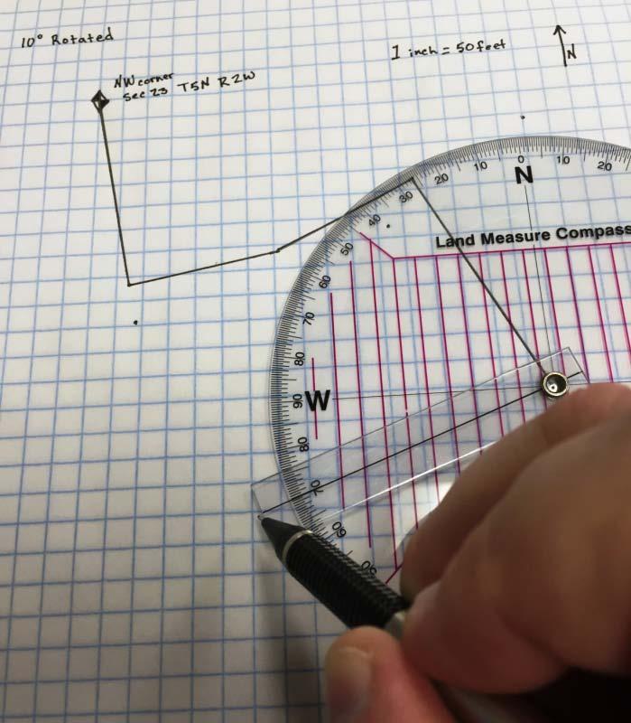
12 Original Rotated Original Rotated 6-11
 For this rotation example we are going to use the same two descriptions used in the above example. This is Method 2 as mentioned in the basic mathematics chapter.")
13 Now if we take both the original and the rotated descriptions and lay them on top of each other, we can see how much 10 makes a difference in how the description sits. B. Rotating Manually (Method 2) For this rotation example we are going to use the same two descriptions used in the above example. This is Method 2 as mentioned in the basic mathematics chapter. Original Rotated Overlapping 6-12

14 The grid lines of the graph paper that run through our section corner as our section lines. We physically rotate the adjusted description using the section corner as the axis of the rotation, and rotate until our first bearing line matches up with the section line. These two descriptions now line up exactly the same. We see that a property description can be rotated mathematically to line up with the rest of the section drawings, and it can also be physically rotated without doing the math, and the result is the same. 6-13
15 Precision of Legal Descriptions Because of various problems, some legal descriptions are not precise and may have a problem closing perfectly. In order to make the reference in this context brief, we could refer to such inaccurate descriptions as bad descriptions. If traversing a bad description starting from the place of beginning and going through all courses and the last course, and it does not return to the place of beginning, it is said that the description does not close. The error(s) may have been created in any course(s) of the description. There is nothing the mapper can do to improve the legal description reflected on the recorded document. Assume that a party owns a parcel of real property conveyed to him by a bad description and he conveys a parcel reflecting a current survey description which closes. It is impossible to locate precisely the new description on a plat with reference to the bad description. The bad description can be shifted to fit the new description only to the extent that the bad description misses closure. The remnant description will miss closure just as far as the Original description did before the new parcel was conveyed. Example 1: Starting Point Bad Description of Parent Parcel Ending Point Closing error of 30 ft New Survey Description 22 ft The illustration mapped is a representation of two parcels. The larger solid lined parcel represents the parent parcel with a bad description. The smaller parcel represented by broken lines in the southwest corner is a good survey description of a parcel being segregated or split off. 6-14
16 For all practical purposes, the two parcels in some instances can be represented as shown in the drawing below. Starting Point Bad Description of Parent Parcel Ending Point ** Consideration should be given to the following: A. Boundaries of adjacent parcels B. Natural or physical boundaries called out by documents for both parcels, such as roads, streams, canals, railroad right-of-ways, fences, ditches, etc... C. Recitation of boundaries called out on previous conveying documents. Since the larger parcel doesn t close by 30 feet, we have that much latitude to locate the smaller parcel as good judgment would dictate. Note the bad description is not improved by this arrangement. The same principle may apply to direct changes. 6-15
17 Example 2: Ending Point Starting Point Bad Description Good Description Solid line represents a bad description owned by party A. Party A sells to Party B via a new description which closes and is represented by the broken line. It would seem reasonable to show party B as the new owner and also change the old description to the new correct description on the tax rolls. *** Doing away with the old lines, we would show only the new description with party B as owner. *** Careful consideration should be given to: A. Boundaries of adjacent parcels. The bad description may follow exactly the title lines of adjoining properties for part of the description. Those lines must be honored. In such a case, the new description may encroach on other parties and (or) result in a remnant description for party A. B. Natural or physical boundaries. C. Recitation of boundaries. 6-16
18 Parcel Splits Very often, in the course of cadastral mapping, the mapper is required to prepare property descriptions for remaining parcels, created when the entire parcel does not change ownership. Example: Party "A" is the owner of the following described property: Beginning at a point South 89 58'52" West feet along the 1/4 section line and North ' from the Southeast corner of section 10 Township 5 North Range 2 West, Salt Lake Base and Meridian. Running thence North 240 feet; thence South 89 58'52" West 100 feet; thence North 15 feet; thence South 89 58'52" West 100 feet; thence South 255 feet; thence North 89 58'52" East 200 feet to the point of beginning. 6-17
19 Party "A" sells to Party "B" the following described property: Beginning at a point South 89 58'52" West feet along the quarter section line and North ' from the Southeast corner of Section 10 Township 5 North Range 2 West, Salt Lake Base and Meridian. Running thence North 89 58'52" East 100 feet; thence North 170 feet; thence South 89 58'52" West 100 feet; thence South 170 feet to the point of beginning. 6-18
20 The remaining parcel is retained by Party "A" There are two common ways to describe a remainder parcel. The first way to describe the remainder parcel is to use the original description from before the split and less out the new description. The second way is to calculate the distances based on the differences between the two descriptions and write a new remainder description. Or Beginning at a point South 89 58'52" West feet along the 1/4 section line and North ' from the Southeast corner of section 10 Township 5 North Range 2 West, Salt Lake Base and Meridian. Running thence North 240 feet; thence South 89 58'52" West 100 feet; thence North 15 feet; thence South 89 58'52" West 100 feet; thence South 255 feet; thence North 89 58'52" East 200 feet to the point of beginning. Less Beginning at a point South 89 58'52" West feet along the quarter section line and North ' from the Southeast corner of Section 10 Township 5 North Range 2 West, Salt Lake Base and Meridian. Running thence North 89 58'52" East 100 feet; thence North 170 feet; thence South 89 58'52" West 100 feet; thence South 170 feet to the point of beginning. Beginning at a point South 89 58'52" West feet along the quarter section line and North Feet from the Southeast corner of Section 10 Township 5 North Range 2 West, Salt Lake Base and Meridian. Running thence North 240 feet; thence South 89 58'52" West 100 feet; thence South 155 feet; thence South 89 58'52" West 100 feet; thence South 155 feet; thence South 89 58'52" West 100 feet; thence South 85 feet; thence North 89 58'52" East 200 feet to the point of beginning. Subdivisions Utah State Code, titles thru 611, and thru 811 provide for the subdivision of land. When a subdivision of land is made, the owner must have an accurate map made of the subdivision in compliance with the Utah State code and Local Ordinances. Upon approval by the governing body, the subdivision map shall be recorded with the County Recorder. The following page is an example of such a recorded subdivision. 6-19
21 The recorded subdivision map operates to dedicate all of the streets, easements, alleys and other public places as part of the dedication and splits the parcels of land as shown. Lots in the above subdivision may be described as: Lot 76 Cherry Ridge 6-20 Subdivision Phase 3, Box Elder County, Utah.
22 Platted areas of town sites, meander lines, river banks and other platted areas can also be described by the lot and block method when the map is recorded. Below is an example of a platted town site. Plat O Tremonton City Survey Some Lots in the above platted area may be described as: Lot 3, Block 2, Plat O, Tremonton City Survey, Box Elder County, Utah 6-21
23 Below is an example of a County Recorder s ownership map developed using elements of drafting and elements of surveying and mapping. 6-22
24 Utah State Code Section provides for the following permitted abbreviations of property descriptions when related to the County Tax Roll. a., ac acre, acres add addition ave avenue beg beginning blk block bet between bdy., bdrs boundary, boundaries ch., chs chain, chains com commencing cont containing deg. or degree symbol degree, degrees dist distance E east E'ly easterly ft foot, feet frac fractional in., ins inch, inches lk., lks link, links lt., lts lot, lots m., min., or ' minute, minutes m. or l more or less N north NE northeast NE'ly northeasterly N'ly northerly NW northwest NW'ly northwesterly pt point 1/4 sec quarter section r., rs range, ranges rd., rds rod, rods R. of W right-of-way s. or " second, seconds S south SE southeast SE'ly southeasterly S'ly southerly st street sub subdivision S.L.M Salt Lake Meridian SW southwest t., tp., tps township, townships th thence U.S. sur United State Survey U.S.M Uintah Special Meridian W west W'ly westerly Utah State Code Section also allows for commonly accepted initial letters, abbreviations, symbols, of railroads and other locally significant figures to be used if they are first approved by the commission. 6-23
25 LAND MEASUREMENT CONVERSION GUIDE 1 Acre = 43,560 square feet 1 Meter Square = square feet 1 Acre = 160 square rods 1 Mile = 5,280 feet 1 Acre = 10 square chains 1 Mile = 8 furlongs 1 Acre = 160 square rods 1 Mile = 320 rods 1 Acre = 160 perches 1 Mile = 80 chains 1 Acre = 160 poles 1 Mile = kilometers 1 Acre =.4047 hectare 1 Mile = 320 perches 1 Acre = 4047 square meters 1 Mile = 320 poles 1 Acre = is about 208 3/4 feet square 1 Mile = 8000 links 1 Centimeter =.3937 inches 1 Mile = 1, meters 1 Centimeter = feet 1 Mile Square = a regular Section of land 1 Chain = 66 feet 1 Mile Square = 27,878,400 square feet 1 Chain = 4 rods 1 Mile Square = 640 acres 1 Chain = 4 perches 1 Mile Square = 259 hectares 1 Chain = 4 poles 1 Mile Square = 2.59 square hectares 1 Chain = 100 links 1 Perch = 25 links 1 Chain = meters 1 Perch = 1 pole 1 Foot = 12 inches 1 Perch = 1 rod 1 Furlong = 660 feet 1 Perch = 16.5 feet 1 Furlong = 40 rods 1 Pole = 16.5 feet 1 Foot = meter 1 Pole = 1 perch 1 Hectare = 10,000 square meters 1 Pole = 1 Rod 1 Hectare = acres 1 Rod = 1 pole 1 Inch =.0254 meter 1 Rod = 1 perch 1 Kilometer = feet 1 Rod = 16.5 feet 1 Kilometer =.62 mile 1 Section = 1 mile long, by 1 mile wide 1 Knot = feet 1 Section = 640 acres 1 Labor = acres 1 Township = 6 miles long, by 6 miles wide 1 League = acres 1 Township = 36 sections 1 Link = 7.92 inches 1 Township = 36 square miles 1 Link =.66 feet 1 Yard = 36 inches 1 Link =.2017 meter 1 Yard = 3 feet 1 Meter = feet 1 Yard Square = 9 square feet 1 Meter = inches 6-24
CHAPTER House Bill No. 1495
 CHAPTER 2000-419 House Bill No. 1495 An act relating to Acme Improvement District, Palm Beach County; amending chapter 28557, Laws of Florida, 1953, as amended; expanding the boundaries of said district,
EXHIBIT A LEGAL DESCRIPTION OF PROPERTY TO BE INCLUDED IN THE DISTRICT
 - - - - EXHIBIT A LEGAL DESCRIPTION OF PROPERTY TO BE INCLUDED IN THE DISTRICT COMMUNITY FACILITIES DISTRICT FOR QUAILWOOD AND ROUWENHORST LEGAL DESCRIPTION JULY 28, 2004 A PORTION OF LAND LYING WITHIN
CHAPTER House Bill No. 1213
 CHAPTER 2015-198 House Bill No. 1213 An act relating to the West Palm Beach Water Catchment Area, Palm Beach County; amending chapter 67-2169, Laws of Florida, as amended; revising boundaries; providing
Starting Bid: $15,000
 Starting Bid: $15,000 Parcel # 12.00593.00 Garage Legal Description Information Lot-005 Block-006 FOREST EDGE ADDITION Eckles Township 20 147 34 Forfeited: 06-222018 Deeded acres: 1.33 Appraised Value
EXHIBIT A LEGAL DESCRIPTION OF AVIGATION EASEMENT Being that certain real property situate in the unincorporated area of the County of Monterey, State
 EXHIBIT A LEGAL DESCRIPTION OF AVIGATION EASEMENT Being that certain real property situate in the unincorporated area of the County of Monterey, State of California, described as follows: Being a portion
DANE COUNTY ORDINANCE AMENDMENT NO: Internal Tracking Number: RECU25760
 DANE COUNTY ORDINANCE AMENDMENT NO: 10246 Internal Tracking Number: RECU25760 Amending Section 10.03 relating to Zoning Districts in the Town of Vienna. The Dane County Board of Supervisors does ordain
when the following proceedings, among others were held and done, to-wit:
 STATE OF COLORADO ) COUNTY OF ADAMS ) At a regular meeting of the Board of County Commissioners for Adams County, Colorado, held at the Administration Building in Brighton, Colorado on the 22 nd day of
Village of Bedford Park ) ) SS County of Cook ) REVISED NOTICE TO SOLICIT PROPOSALS
 ) SS County of Cook ) REVISED NOTICE TO SOLICIT PROPOSALS") Village of Bedford Park ) ) SS County of Cook ) REVISED NOTICE TO SOLICIT PROPOSALS Notice is hereby given the Village of Bedford Park, Cook County, Illinois is soliciting proposals for the sale of real
Village of Bedford Park ) ) SS County of Cook ) REVISED NOTICE TO SOLICIT PROPOSALS Notice is hereby given the Village of Bedford Park, Cook County, Illinois is soliciting proposals for the sale of real
SPECIAL USE PERMIT - SUP Metcalf Avenue
 NOTICE OF PUBLIC HEARING CITY PLANNING COMMISSION CITY OF OVERLAND PARK, KANSAS Notice is hereby given that the City Planning Commission of Overland Park, Kansas, will hold a public hearing Monday, March
Planning & Zoning Commission
 Preliminary Plat Westwood, Section 3 Planning & Zoning Commission Planning & Development Department March 21, 2016 Request Subdivide approximately 38.1 acres of previously unplatted property to create
M I N U T E S OKLAHOMA COUNTY PLANNING COMMISSION
 M I N U T E S OKLAHOMA COUNTY PLANNING COMMISSION September 21, 2000 1:30 P.M. The meeting of the Oklahoma County Planning Commission convened and was called to order by Ms. Cheryl Dorrance, at 1:30 P.M.,
COUNCIL COMMUNICATION
 Meeting Date: March 20, 2018 COUNCIL COMMUNICATION Agenda Item: Agenda Location: Action Items Work Plan # Legal Review: 1 st Reading 2 nd Reading Subject: A resolution approving the final design for the
A G E N D A OKLAHOMA COUNTY PLANNING COMMISSION. November 16, Approval of Minutes of the Previous Meeting: (October 19, 2006)
") A G E N D A OKLAHOMA COUNTY PLANNING COMMISSION ROOM 103 1:30 p.m. November 16, 2006 1. Notice of meeting posted November 9, 2006. 2. Call to Order. 3. Roll Call. 4. Approval of Minutes of the Previous
A G E N D A OKLAHOMA COUNTY PLANNING COMMISSION ROOM 103 1:30 p.m. November 16, 2006 1. Notice of meeting posted November 9, 2006. 2. Call to Order. 3. Roll Call. 4. Approval of Minutes of the Previous
SEWER CONNECTION FEES
 100.01 Connection Fees Required 100.04 Establishment of Sewer Districts 100.02 East Sanitary Sewer District 100.05 East Southside Drive Sewer Connection District 100.03 West Sanitary Sewer District 100.01
CHAPTER House Bill No. 1311
 CHAPTER 2017-216 House Bill No. 1311 An act relating to the Lehigh Acres Municipal Services Improvement District, Lee and Hendry Counties; amending chapter 2015-202, Laws of Florida; expanding the territorial
September 18, Mr. Matthew Morris Kolter Acquisitions, LLC 6981 Professional Parkway E. Sarasota, Florida Dear Mr.
 JIM C. STUDIALE Director Community Development Department September 18, 2014 Mr. Matthew Morris Kolter Acquisitions, LLC 6981 Professional Parkway E. Sarasota, Florida 34240 RE: Minor Modification of PUD
BEFORE THE BOARD OF COUNTY COMMISSIONERS FOR THE COUNTY OF TILLAMOOK IN THE STATE OF OREGON ) )
 )") COUN1Y COOID'JOlJIINAI_ AFTER RECORDING RETURN TO AND SEND ALL TAX STATEMENTS TO: Tillamook County 201 Laurel Avenue Tillamook, OR 97141 Tillamook County, Oreqon 2014 002077 051091201408:17:08AM - DEED-ORDER
COUN1Y COOID'JOlJIINAI_ AFTER RECORDING RETURN TO AND SEND ALL TAX STATEMENTS TO: Tillamook County 201 Laurel Avenue Tillamook, OR 97141 Tillamook County, Oreqon 2014 002077 051091201408:17:08AM - DEED-ORDER
Downum Title Services, Inc. TITLE REPORT Work Order #6581
 17030 Main Street South Blountstown, Florida 32424 Downum Title Services, Inc. JUDY DOWNUM Telephone: (850) 674-3533 Fax: (850) 674-1343 TITLE REPORT Work Order #6581 FOR GULF COUNTY TAX COLLECTOR 1000
San Bernardino County Tax Sale Auction Opens August 11AM (ET) Minimum Auction Ends Legal Description ID#
 Minimum Auction Ends Legal Description ID#") Minimum Ends Legal Description Bid Aug 4th (ET) 387071 0136-231-01-0000 SHAYS HALF ACRES LOT 17 $100 1:00 PM 387072 0172-311-37-0000 TR 10720 LOT 6 EX COM AT MOST NLY COR LOT 8 SD TR 10720 ON SELY LI OF
Minimum Ends Legal Description Bid Aug 4th (ET) 387071 0136-231-01-0000 SHAYS HALF ACRES LOT 17 $100 1:00 PM 387072 0172-311-37-0000 TR 10720 LOT 6 EX COM AT MOST NLY COR LOT 8 SD TR 10720 ON SELY LI OF
City of East Moline Committee of the Whole
 City of East Moline Committee of the Whole City Council Chambers 915 16 th Avenue East Moline, IL 61244 DATE: Monday, May 5 th, 2014 TIME: Immediately Following the Regular Council Meeting 1 Enterprise
PRELIMINARY DEVELOPMENT AREA A DEVELOPMENT AREA B PROPOSED ZONING - NS 1,435,131 SQUARE FEET, ACRES
 DEVELOPMENT AREA A Inte rs tate 485 PRELIMINARY PROPOSED ZONING - MX-1 1,479,033 SQUARE FEET, 33.954 ACRES MX-1 NS DEVELOPMENT AREA B PROPOSED ZONING - NS 1,435,131 SQUARE FEET, 32.946 ACRES Albe mar le
ORDINANCE NO CITY OF MONTICELLO ADOPTING TAX INCREMENT FINANCING TAX INCREMENT FINANCING DISTRICT II
 ORDINANCE NO. 2006-59 CITY OF MONTICELLO ADOPTING TAX INCREMENT FINANCING TAX INCREMENT FINANCING DISTRICT II WHEREAS, the City of Monticello, Illinois, desires to adopt tax increment financing pursuant
2018 REAL PROPERTY TAX FORECLOSURE ROLL
 ACCOUNT NUMBER: 032301-3-023-1004 TAXPAYER NAME: HARTSTROM GRETA F ET AL LEGAL DESCRIPTION: Section 03 Township 23 Range 1W THE SOUTH HALF OF THE NORTH HALF OF THE SOUTH HALF OF THE SOUTHEAST QUARTER OF
All of Lot 5, Except the North 783 feet, Wolf Creek Acres, a subdivision of land in the City of Overland Park, Johnson County, Kansas.
 NOTICE OF PUBLIC HEARING CITY PLANNING COMMISSION CITY OF OVERLAND PARK, KANSAS Notice is hereby given that the City Planning Commission of Overland Park, Kansas, will hold a public hearing Monday, January
AGENDA BILL. Beaverton City Council Beaverton, Oregon FOR AGENDA OF: ~1-8 BILL NO: BUDGET IMPACT
 AGENDA BILL SUBJECT: An Ordinance Withdrawing Territory From The Tualatin Valley Water District and Declaring An Emergency Beaverton City Council Beaverton, Oregon 3-27-18 FOR AGENDA OF: ~1-8 BILL NO:
City of Chicago O Office of the City Clerk. Document Tracking Sheet
 City of Chicago Office of the City Clerk O2019-2185 Document Tracking Sheet Meeting Date: Sponsor(s): Type: Title: Committee(s) Assignment: 3/13/2019 Emanuel (Mayor) Ordinance Adoption of Tax Increment
NOTICE OF PUBLIC HEARING
 NOTICE OF PUBLIC HEARING Notice is hereby given that the first and second public hearing of a proposed annexation area described below will be held by the City Council of the City of Rockport, Texas, at
EXHIBIT 314B TRACT I
 - 2878 EXHIBIT 314B 122312 PRESTON CENTER SPECIAL PURPOSE DISTRICT TRACT BOUNDARY DESCRIPTIONS TRACT I BEING all of City Block 1/5625 and is further described as being a tract of land beginning at a point
ORDINANCE NO. SB-3131
 ORDINANCE NO. SB-3131 AN ORDINANCE MAKING FINDINGS AND ESTABLISHING A STAR BOND PROJECT DISTRICT WITHIN THE CITY OF OVERLAND PARK, KANSAS PURSUANT TO K.S.A. 12-17,160 ET SEQ., AS AMENDED (BLUHAWK STAR
ORDINANCE NO AN ORDINANCE MAKING CERTAIN FINDINGS AND ESTABLISHING THE MALL REDEVELOPMENT DISTRICT
 Introduced: January 20, 2015 Passed: January 20, 2015 Published: January 23, 2015 ORDINANCE NO. 2015-2 AN ORDINANCE MAKING CERTAIN FINDINGS AND ESTABLISHING THE MALL REDEVELOPMENT DISTRICT WHEREAS, K.S.A.
-Forest Basics- Michigan Land Survey. Adapted from the on-line Teachers Guide
 -Forest Basics- Michigan Land Survey Adapted from the on-line Teachers Guide http://mff.dsisd.net 1 2 U.S. Public Land Survey Modern land survey is based largely on proposals developed by Thomas Jefferson
ORDINANCE NO
 ORDINANCE NO. 2008-0390 AN ORDINANCE OF THE CITY OF NEWCASTLE, WASHINGTON, DECLARING PUBLIC USE AND NECESSITY RELATED TO REAL PROPERTY TO BE CONDEMNED AS REQUIRED FOR A MUNICIPAL PROJECT KNOWN AS THE NEWCASTLE
MEMORANDUM OF LEASE RECITALS
 MEMORANDUM OF LEASE THE STATE OF TEXAS COUNTY OF HARRIS THIS MEMORANDUM OF LEASE (this "Memorandum") is made and entered into effective as of the 17th day of May, 2001, by and between HARRIS COUNTY SPORTS
QUIT-CLAIM DEED. STONE CLIFF, LC, a Utah limited liability company, and TRAVELLER/STONE CLIFF,
 Recorded at Request of: Stone Cliff Owners Association c/o John D. Richards III Richards Kimble & Winn, PC 2040 E. Murray-Holladay Rd., Suite 102 Salt Lake City, UT 84117 Mail tax notice to: Stone Cliff
RESOLUTION OF ADVISABILITY AND AUTHORIZATION NO. 7841
 1 2 3 4 5 6 7 8 9 10 11 12 13 14 15 16 17 18 19 20 21 22 23 24 25 26 27 28 29 30 31 32 33 34 35 (Published in the Topeka Metro News August 9, 2006) RESOLUTION OF ADVISABILITY AND AUTHORIZATION NO. 7841
Arthrex, Inc Creekside Boulevard Naples FL Creekside Commerce Park CPUD
 Arthrex, Inc. 1370 Creekside Boulevard Naples FL 34108 239.403.6804 dgenson@barroncollier.com 27 48S 25E Please see Exhibit 2 Please see Exhibit 3 X X Please see Exhibit 5 Exhibit 2 Legal Description
FIRST AMENDMENT TO METRO NORTH CROSSING TAX INCREMENT FINANCING PLAN
 FIRST AMENDMENT TO METRO NORTH CROSSING TAX INCREMENT FINANCING PLAN KANSAS CITY, MISSOURI TIF COMMISSION APPROVAL: 12/13/17 12-2-17 DATE RESOLUTION NO. CITY COUNCIL APPROVAL: 2/1/18 180020 DATE ORDINANCE
COMPASS DIRECTION AND BEARINGS
 Mathematics Revision Guides Compass Direction and Bearings Page 1 of 7 M.K. HOME TUITION Mathematics Revision Guides Level: GCSE Foundation Tier COMPASS DIRECTION AND BEARINGS Version: 1.1 Date: 06-02-2009
FEASIBILITY REPORT STORM DRAINAGE IMPROVEMENTS TERRACE AND METCALF CITY OF OVERLAND PARK JOHNSON COUNTY, KANSAS
 March 2, 2011 FEASIBILITY REPORT STORM DRAINAGE IMPROVEMENTS STANLEY STORM DRAINAGE IMPROVEMENTS, 151sT TERRACE AND METCALF CITY OF OVERLAND PARK JOHNSON COUNTY, KANSAS DESCRIPTION: This report relates
ORDINANCE NO. ASMT-3189
 ORDINANCE NO. ASMT-3189 AN ORDINANCE LEVYING ASSESSMENTS ON LOTS, PIECES AND PARCELS OF GROUND FOR THE PURPOSE OF PAYING THE COST FOR THE CONSTRUCTION OF A FLOOD CONTROL PROJECT ALONG NEGRO CREEK BETWEEN
IN THE CIRCUIT COURT OF PULASKI COUNTY, ARKANSAS FIFTH DIVISION. REGIONS BANK, an Alabama banking corporation
 IN THE CIRCUIT COURT OF PULASKI COUNTY, ARKANSAS FIFTH DIVISION REGIONS BANK, an Alabama banking corporation PLAINTIFF v. Case No. 60CV-2012-4668 ARRINGTON APTS II, LIMITED PARTNERSHIP, an Arkansas limited
More Restrictive Provisions of LDC to Apply
 APPENDIX E Section E101 Purpose and Intent A Parcel Specific Future Land Use with conditions (PSLUC) may be established as the result of a comprehensive plan amendment, which has been reviewed and adopted
ORDINANCE NO AMENDMENT TO THE CITATION ESTATES MPD DEVELOPMENT AGREEMENT
 ORDINANCE NO. 2015- AMENDMENT TO THE CITATION ESTATES MPD DEVELOPMENT AGREEMENT AN ORDINANCE OF THE CITY COUNCIL OF THE CITY OF PALM COAST, FLORIDA, PROVIDING FOR THE SECOND AMENDED AND RESTATED MASTER
PRELIMINARY POINT OF BEGINNING SEE DETAIL "A" ESCONDIDO PIPELINE MATCHLINE 30' P.R.W.E.
 MATCHLINE POINT OF BEGINNING SEE DETAIL "A" Notes: 1. This plat was prepared without the benefit of a current Title Report. All deeds were provided by the client and may not reflect current ownership.
CHAPTER House Bill No. 1509
 CHAPTER 2006-358 House Bill No. 1509 An act relating to Flagler Estates Road and Water Control District, St. Johns County; amending chapter 98-529, Laws of Florida; providing additional powers of the district
CITY OF GAYLORD RESOLUTION NUMBER TOWN OF DRYDEN SIBLEY COUNTY, MINNESOTA CITY OF GAYLORD SIBLEY COUNTY, MINNESOTA
 CTY OF GAYLORD RESOLUTON NUMBER TOWN OF DRYDEN SBLEY COUNTY, MNNESOTA CTY OF GAYLORD SBLEY COUNTY, MNNESOTA N THE MATTER OF THE ORDERLY ANNEXATON BETWEEN THE CTY OF GAYLORD DRYDEN TOWNSHP PURSUANT TO MNNESOTA
Advisory Circular. Legal Land Survey for AZR Clearance Attestation
 Advisory Circular Subject: Legal Land Survey for AZR Clearance Attestation Issuing Office: Civil Aviation, Standards Document No.: AC 602-003 File Classification No.: Z 5000-34 Issue No.: 01 RDIMS No.:
SUMMARY: The Principal Deputy Assistant Secretary- Indian Affairs made a final agency
 (4337-15-P) DEPARTMENT OF THE INTERIOR Bureau of Indian Affairs [178A2100DD/AAKC001030/AOA501010.999900 253G] Land Acquisitions; Wilton Rancheria AGENCY: ACTION: Bureau of Indian Affairs, Interior. Notice.
BE IT ORDAINED BY THE MAYOR AND COUNCIL OF THE CITY OF GROTON:
 BE IT ORDAINED BY THE MAYOR AND COUNCIL OF THE CITY OF GROTON: WHEREAS, Robert S. Porter of the Town of Groton has agreed to sell and convey a certain tract of land with the improvements thereon commonly
116TH STREET AND BROOKS SCHOOL ROAD ORDINANCE NO B
 116TH STREET AND BROOKS SCHOOL ROAD ORDINANCE NO. 031802B A Text Amendment to Ordinance No. 071000A - An Ordinance Establishing the 116th Street and Brooks School Road Planned Unit Development District
For 2013 Foreclosures of 2010 and prior taxes. All Records Interest Computed As Of Foreclosure Date
 Page: 1/7 001 005 017 00 1,043.08 575.81 1,618.89 7,100 2012 2011 2010 PARCEL IN NE FRL 1/4 SEC 5 DESC AS: COM C/L FINDLEY RD 141 FT WLY FROM W LN RR R/W TH S PRL WITH RR 10 RDS TH W PRL WITH HWY 12 RDS
Enclosed please find an executed and notarized Certificate of Completion regarding North Center Senior Housing at 2324 West Irving Park Road.
 May 14,2008 City of Chicago Richard M. Daley, Mayor Department of Planning and Developme.nt Arnold L. Randall Commissioner City Hall, Room 1000 121 North LaSalle Street Chicago, Illinois 60602 312 744-4190
Notice of Trustee's Sale
 Notice of Trustee's Sale ASSERT AND PROTECT YOUR RIGHTS AS A MEMBER OF THE ARMED FORCES OF Tl-IE UNITED STATES. IF YOU ARE OR YOUR SPOUSE IS SERVING ON ACTIVE MILITARY DUTY, INCLUDING ACTIVE MILITARY DUTY
ORDINANCE ORDINANCE ANNEXING PROPERTY TSM GREENBRIER LLC
 ORDINANCE 2018-7 ORDINANCE ANNEXING PROPERTY TSM GREENBRIER LLC RECITALS WHEREAS, the City ofbuffalo has received a Petition for Annexation by Ordinance from TSM Greenbrier LLC for the annexation of97
NOTICES OF SHERIFF'S SALE
 Updated: 01/11/19 at 1:18 AM NOTICES OF SHERIFF'S SALE Date & Time of Sale: Wed, Dec 12, 2018 at 1:00 pm Sheriff Sale File number: 14-18-0025-SS Judgment to be Satisfied: $38,582.48 Cause Number: 14C01-1712-MF-000589
CITY OF ZUMBROTA ORDINANCE NO
 CTY OF ZUMBROTA ORDNANCE NO 272 AN ORDNANCE OF THE CTY OF ZUMBROTA MNNESOTA ANNEXNG LAND LOCATED N ZUMBROTA TOWNSlllP GOODHUE COUNTY MNNESOTA PURSUANT TO MNNESOTA STATUTES 4433 SUBDVSON 2(3) PERMTTNG ANNEXATON
Descriptor term: Descriptor code: Issue date: SECTION A ORGANIZATION PLAN
 SECTION A ORGANIZATION PLAN A.1...DISTRICT LEGAL STATUS A.2...DISTRICT LEGAL DESCRIPTION A.3...ORGANIZATION PLAN A.4...ORGANIZATIONAL CHART A.5...SCHOOL ATTENDANCE AREAS A.6...SCHOOL CALENDAR DISTRICT
Year GRANITE RIDGE. City of Fishers Planned Development Ordinance # v
 GRANITE RIDGE v.03.09.15 City of Fishers Planned Development Ordinance # 020215 1.01 Declaration, Purpose and Intent, and Permitted Uses Declaration Ordinance No. 020215 ("this Ordinance") Adopted: The
VOLUME I OF II HARRIS RANCH SPECIFIC PLAN 2007 (AMENDMENT 6.1, ORDINANCE 11-13)
") VOLUME I OF II HARRIS RANCH SPECIFIC PLAN 2007 (AMENDMENT 6.1, ORDINANCE 11-13) OWNER ACKNOWLEDGMENTS DEVELOPMENT MANAGER LEGAL In Loving memory of Dallas Harris By George we can do it if we work hard
VOLUME I OF II HARRIS RANCH SPECIFIC PLAN 2007 (AMENDMENT 6.1, ORDINANCE 11-13) OWNER ACKNOWLEDGMENTS DEVELOPMENT MANAGER LEGAL In Loving memory of Dallas Harris By George we can do it if we work hard
Site Location Map and 4424 Excelsior Boulevard, and 3743 Monterey Drive
 Site Location Map 4400 and 4424 Excelsior Boulevard, and 3743 Monterey Drive www.bkvgroup.com EXCELSIOR AND MONTEREY DRIVE 10/20/2015 www.bkvgroup.com EXCELSIOR AND MONTEREY DRIVE 10/20/2015 SHEET 2 OF
EXHIBIT A BOUNDARY RIDGE PROPERTY
 EXHIBIT A BOUNDARY RIDGE PROPERTY Legal Description: A tract of land situated in Government Lots 1 and 2, Section 10 and Government Lots 1 and 2, Section 11, Township 40 North, Range 1 West of the Willamette
APPROVED BY REVIEW COMMITTEE April 13, 2015
 APPROVED BY REVIEW COMMITTEE April 13, 2015 CARLTON LANDING ECONOMIC DEVELOPMENT PROJECT PLAN PREPARED BY: THE TOWN OF CARLTON LANDING, OKLAHOMA JOANNE CHINNICI, MAYOR JEFF CLICK, TOWN TRUSTEE RICHARD
ORDINANCE NO. WHEREAS, the city council finds that it is in the public interest to amend Article 521 as
 Page 160135 1-13-16 ORDINANCE NO. 29989 An ordinance amending Article 521, PD 521, of Chapter 51P, Dallas Development Code: Planned Development District Regulations, of the Dallas City Code; amending the
CHAPTER House Bill No. 655
 CHAPTER 2016-248 House Bill No. 655 An act relating to the City of Jacksonville, Duval County; amending chapter 87-471, Laws of Florida, as amended; establishing special zones in downtown Jacksonville;
WARRANTY DEED (Maine Statutory Short Form) KNOW ALL PERSONS BY THESE PRESENTS, that Winslow H. Pillsbury, of the Town of
 KNOW ALL PERSONS BY THESE PRESENTS, that Winslow H. Pillsbury, of the Town of") WARRANTY DEED (Maine Statutory Short Form) KNOW ALL PERSONS BY THESE PRESENTS, that Winslow H. Pillsbury, of the Town of Cape Elizabeth, County of Cumberland and State of Maine, for consideration paid,
WARRANTY DEED (Maine Statutory Short Form) KNOW ALL PERSONS BY THESE PRESENTS, that Winslow H. Pillsbury, of the Town of Cape Elizabeth, County of Cumberland and State of Maine, for consideration paid,
CITY OF HAYS COMMISSION MEETING CITY HALL, 1507 MAIN STREET, HAYS, KS THURSDAY, DECEMBER 13, :30 P.M. AGENDA
 CITY OF HAYS COMMISSION MEETING CITY HALL, 1507 MAIN STREET, HAYS, KS THURSDAY, DECEMBER 13, 2018 6:30 P.M. AGENDA 1. Call to order by Chairperson. 2. MINUTES: Consider approval of the minutes from the
NOTICES OF SHERIFF'S SALE
 Updated: 05/03/18 at 1:27 AM NOTICES OF SHERIFF'S SALE Date & Time of Sale: Thu, Jun 14, 2018 at 10:00 am Sheriff Sale File number: 42-18-0030-SS Judgment to be Satisfied: $1,860,456.55 Cause Number: 42D01-1710-MF-000051
IN THE CIRCUIT COURT OF THE STATE OF OREGON FOR THE COUNTY OF MARION Civil Department ) ) ) ) ) ) ) ) ) ) ) ) ) ) ) ) )
 ) ) ) ) ) ) ) ) ) ) ) ) ) ) ) )") 1 2 3 4 5 6 IN THE CIRCUIT COURT OF THE STATE OF OREGON FOR THE COUNTY OF MARION Civil Department 7 8 9 10 11 12 13 14 15 CREEKSIDE HOMEOWNERS ASSOCIATION, INC., an Oregon non-profit corporation, v. Plaintiff,
1 2 3 4 5 6 IN THE CIRCUIT COURT OF THE STATE OF OREGON FOR THE COUNTY OF MARION Civil Department 7 8 9 10 11 12 13 14 15 CREEKSIDE HOMEOWNERS ASSOCIATION, INC., an Oregon non-profit corporation, v. Plaintiff,
What is the distance from Minneapolis to Duluth, computed via trunk highways? 155 miles (1 point) see chart at top of map
 see chart at top of map") Gopher Science Olympiad Invitational Road Scholar 2018 Answer Key; 60 points total MN State Highway map (15 points) What is the scale of this map? 1/16 inch = 1 mile (1 point for number, 1 point for units)
Gopher Science Olympiad Invitational Road Scholar 2018 Answer Key; 60 points total MN State Highway map (15 points) What is the scale of this map? 1/16 inch = 1 mile (1 point for number, 1 point for units)
THIS ASSIGNMENT AND ASSUMPTION OF CONC in AGREEMENT (this
 TfflS DOCUMENT WAS PREPARED BY: Kirkland & Ellis LLP 300 North LaSalle Chicago, Illinois 60654 Attention: Andrew Small, Esq. AFTER RECORDING RETURN TO: Allen & Overy LLP 1221 Avenue of the Americas New
Where are you right now? How fast are you moving? To answer these questions precisely, you
 4.1 Position, Speed, and Velocity Where are you right now? How fast are you moving? To answer these questions precisely, you need to use the concepts of position, speed, and velocity. These ideas apply
SWIMMING POOL BUILDING PERMIT REQUIREMENTS FOR THE UNINCORPORATED TERRITORY OF DOUGLAS COUNTY, KANSAS
 SWIMMING POOL BUILDING PERMIT REQUIREMENTS FOR THE UNINCORPORATED TERRITORY OF DOUGLAS COUNTY, KANSAS ALL CONSTRUCTION SHALL BE BUILT IN ACCORDANCE WITH STANDARDS SET FORTH IN THE 2012 International Code
NOTICES OF SHERIFF'S SALE
 Updated: 04/04/17 at 4:47 PM NOTICES OF SHERIFF'S SALE Date & Time of Sale: Thu, Mar 02, 2017 at 10:00 am Sheriff Sale File number: 33-17-0032-SS Judgment to be Satisfied: $62,883.45 Cause Number: 33C02-1508-MF-000107
MEASUREMENTS LAND LINEAR MEASURE... 2 LAND AREA MEASURE... 3 VOLUME MEASURE WEIGHT or MASS... 5 MEASURES OF ANGLES AND ARCS...
 MEASUREMENTS LAND LINEAR MEASURE... 2 LAND AREA MEASURE... 3 VOLUME MEASURE... 4 WEIGHT or MASS... 5 MEASURES OF ANGLES AND ARCS... 6 AREAS AND VOLUME CALCULATIONS... 6 1 Imperial/US measurements LAND
City Council Meeting 8. B. Meeting Date: 09/08/2015. Agenda Category: New Business. Subject: Establishment of a STAR Bond Project District
 City Council Meeting 8. B. Meeting Date: 09/08/2015 Submitted By: Kathy Sexton, City Manager Agenda Category: New Business Subject: Establishment of a STAR Bond Project District Guests: Korb Maxwell, Attorney,
ORDINANCE NO AMENDMENT TO ORDINANCE NO NASSAU COUNTY, norida. WHEREAS, on the 28th day of January, 1991, the Board of County
 ORDINANCE NO. 99-23 AMENDMENT TO ORDINANCE NO. 91-04 NASSAU COUNTY, norida WHEREAS, on the 28th day of January, 1991, the Board of County Commissioners, Nassau County, Florida (the "Board"), did adopt
PART 3 MODULE 6 GEOMETRY: UNITS OF GEOMETRIC MEASURE
 PART 3 MODULE 6 GEOMETRY: UNITS OF GEOMETRIC MEASURE LINEAR MEASURE In geometry, linear measure is the measure of distance. For instance, lengths, heights, and widths of geometric figures are distances,
CHAPTER 13 DESIGNATING LEGAL BOUNDARIES ARTICLE 4 - AGRICULTURAL DISTRICTS
 CHAPTER 13 DESIGNATING LEGAL BOUNDARIES ARTICLE 4 - AGRICULTURAL DISTRICTS SECTIONS: Sections 13-4-101 to 108, inclusive. Agricultural District "A" - general provisions. Section 13-4-101. Legal boundary
BELLALAGO CLUB MEMBERSHIP FEE SCHEDULE
 THIS INSTRUMENT PREPARED BY: DENNIS J. GETMAN, ESQ. Avatar Properties Inc. 201 Alhambra Circle, 12 th Floor Coral Gables, Florida 33134 LARRY WHALEY OSCEOLA COUNTY, FLORIDA CLERK OF CIRCUIT COURT DLB Date
CANADA PROVINCE OF BRITISH COLUMBIA
 Note: This supplementary Letters Patent has been consolidated from the Supplementary Letters Patents of the three Regional Districts of the Okanagan valley: North Okanagan Regional District; Central Okanagan
Fall 2008 RED Barcode Here Physics 105, sections 1 and 2 Please write your CID Colton
 Fall 2008 RED Barcode Here Physics 105, sections 1 and 2 Exam 1 Please write your CID Colton 2-3669 3 hour time limit. One 3 5 handwritten note card permitted (both sides). Calculators permitted. No books.
Vectors in the City Learning Task
 Vectors in the City Learning Task Amy is spending some time in a city that is laid out in square blocks. The blocks make it very easy to get around so most directions are given in terms of the number of
AFL Field Umpire Positioning Guidelines Three Field Umpire System
 AFL Field Umpire Positioning Guidelines Three Field Umpire System CONTENTS Introduction Definitions Centre Bounces Boundary throw ins Field bounces Initial positioning Set play Positioning General play
SECTION 3 STREET DESIGN
 3.01 GENERAL SECTION 3 STREET DESIGN For purposes of geometric and structural design, streets shall be classified according to the following table. The City Engineer will determine the class of all proposed
CB TO AUTHORIZE THE CHIEF TO PLACE PROPERTY IN BRYAN COUNTY IN TRUST STATUS WITH THE UNITED STATES OF AMERICA
 CB- 141-16 TO AUTHORIZE THE CHIEF TO PLACE PROPERTY IN BRYAN COUNTY IN TRUST STATUS WITH THE UNITED STATES OF AMERICA IN THE TRIBAL COUNCIL OF THE CHOCTAW NATION ANTHONY DILLARD INTRODUCED THE FOLLOWING
Lat. & Long. Review. Angular distance N or S of equator Equator = 0º Must indicate N or S North pole = 90º N
 Navigation Part 2 1 Lesson Objectives Understand how a ships compass works and how it is used for navigation Measure distances on nautical charts Plot a course on a nautical chart Correct course headings
ST. TAMMANY PARISH COUNCIL ORDINANCE
 ST. TAMMANY PARISH COUNCIL ORDINANCE ORDINANCE CALENDAR NO: 4748 COUNCIL SPONSOR: GOULD/BRISTER INTRODUCED BY: MR. STEFANCIK ORDINANCE COUNCIL SERIES NO: PROVIDED BY: PLANNING SECONDED BY: MR. ARTIGUE
ORDINANCE NO. WHEREAS, Downtown Bellingham and the Fairhaven commercial core are places where people come to play, work, shop, and live;
 ORDINANCE NO. AN ORDINANCE OF THE CITY OF BELLINGHAM, WASHINGTON AMENDING BELLINGHAM MUNICIPAL CODE PROVISIONS 10.24.070, 11.48.140, 11.52.010, EXTENDING THE HOURS OF RESTRICTION FOR SITTING AND LYING
BOARD OF ALDERMEN AGENDA
 NOTICE OF MEETING CITY OF BRANSON BOARD OF ALDERMEN Special Meeting Thursday, March 10, 2016 5:00 p.m. Council Chambers Branson City Hall 110 W. Maddux Meeting Called to Order Roll Call AGENDA REGULAR:
City of Crowley Special Council Meeting Notice:
 CITY OF CROWLEY SPECIAL COUNCIL MEETING NOVEMBER 5, 2003 The Mayor and Board of Aldermen of the City of Crowley, Louisiana, the governing authority of the City of Crowley, met in a special session at 6:00
Enhanced Features and Functions Guide. English
 Enhanced Features and Functions Guide Enhanced Features and Functions Guide This booklet contains instructions for using additional functions (mainly on the model with the exterior rotating bezel). Use
PUBLIC NOTICE: TO ALL CONCERNED CITIZENS OF HIALEAH GARDENS, FLORIDA. NOTICE TO BE POSTED AT CITY HALL.
 Mayor Yioset De La Cruz City Council Members Chairman Luciano Lucky García Vice Chairman Rolando Roly Piña Council member Jorge A. Merida Council member Jorge Gutierrez Council member Elmo L. Urra PUBLIC
An Act respecting Ville de Rivière-du-Loup
 FIRST SESSION THIRTY-SEVENTH LEGISLATURE Bill 204 (Private) An Act respecting Ville de Rivière-du-Loup Introduced 13 November 2003 Passage in principle 18 December 2003 Passage 18 December 2003 Assented
Prior Lake American
 June 30, 2012 B7 continued on next page publicnotices NOTICE OF HEARING ON PETITION cooperative, by Energy), a Minnesota, Western and political subdivision,, by its Board of Irrevocable Trust, dated February
Notice of Amended Proposed Withdrawal; Partial Termination of Segregative. Effect; Arizona, California, Colorado, Nevada, New Mexico, and Utah
 This document is scheduled to be published in the Federal Register on 12/17/2012 and available online at http://federalregister.gov/a/2012-30295, and on FDsys.gov 4310-84 DEPARTMENT OF THE INTERIOR Bureau
Walk - Run Activity --An S and P Wave Travel Time Simulation ( S minus P Earthquake Location Method)
") Walk - Run Activity --An S and P Wave Travel Time Simulation ( S minus P Earthquake Location Method) L. W. Braile and S. J. Braile (June, 2000) braile@purdue.edu http://web.ics.purdue.edu/~braile Walk
Walk - Run Activity --An S and P Wave Travel Time Simulation ( S minus P Earthquake Location Method) L. W. Braile and S. J. Braile (June, 2000) braile@purdue.edu http://web.ics.purdue.edu/~braile Walk
Surveying Fundamentals and Practices, 5/e
 Online Instructor s Manual to accompany Surveying Fundamentals and Practices, 5/e Jerry Nathanson Michael T. Lanzafama Philip Kissam Upper Saddle River, New Jersey Columbus, Ohio Copyright 2010 by Pearson
in the manner and way provided by law and the rules and
 IN THE STATE OIL AND GAS BOARD OF MISSISSIPPI RE: PETITION OF OXY USA INC. TO AMEND THE ' ' ial FIELD RULES FOR N0RTH MUD CR EK amp c iqqi FIELD, WILKINSON COUNTY, MISSISSIPPI "" ' DOCKET NO. 205-^1-74?
THE 2018 ROSENTHAL PRIZE for Innovation in Math Teaching. Geometry Project: DARTBOARD
 THE 2018 ROSENTHAL PRIZE for Innovation in Math Teaching Geometry Project: DARTBOARD Geometric Probability Theoretical Probability and Experimental Probability Elizabeth Masslich Geometry grades 6-12 Table
GCSE Mathematics Calculator Foundation Tier Free Practice Set 5 1 hour 30 minutes ANSWERS. Marks shown in brackets for each question (2)
") MathsMadeEasy 3 GCSE Mathematics Calculator Foundation Tier Free Practice Set 5 1 hour 30 minutes ANSWERS Marks shown in brackets for each question Typical Grade Boundaries C D E F G 76 60 47 33 20 Legend
MathsMadeEasy 3 GCSE Mathematics Calculator Foundation Tier Free Practice Set 5 1 hour 30 minutes ANSWERS Marks shown in brackets for each question Typical Grade Boundaries C D E F G 76 60 47 33 20 Legend