2012 Diamond Complex Assessment BLM administered: Battle Mountain, Ely, Elko districts
|
|
|
- Felicia Wright
- 5 years ago
- Views:
Transcription
 jurisdiction Preliminary assessment covers the Diamond HMA from Corta as the northernmost point through")
1 2012 Diamond Complex Assessment BLM administered: Battle Mountain, Ely, Elko districts wild horse removal scheduled January 2013 Horse Canyon, Diamond HMA July 2012 Preliminary Report (Final Version) of Drought/Range assessment Diamond Herd Management Area, Bureau of Land Management (BLM) jurisdiction Preliminary assessment covers the Diamond HMA from Corta as the northernmost point through Walters Canyon. Second visit to specified areas and assessment South into Blackpoint scheduled. 1
2 Table of Contents Overview of the Herd Management Area page 3 Overview of Findings page 4 Important Notes on the Diamond HMA page 6 Recommendations page 7 Photographs page 8 2
3 Overview of the Herd Management Area: Currently the BLM is planning a removal operation in the Diamonds. The Diamonds comprise three areas: The Diamond HMA is approximately 40 miles long and averages 6-9 miles wide extending from the ridge down slope along the western face of the Diamond Mountain Range, comprising 164,737 acres. The Diamond Hills North HMA comprises the northernmost portion of the Complex and is approximately 12 miles long by 12 miles wide encompassing 69,305 acres of public land. The Diamond Hills South HMA is located in the most northeastern tip of the Diamond Mountain Range comprising the smallest portion of the Complex at 21,162 acres of public land. For a total of 255,204 acres. The BLM estimates populations as follows: Diamond at 342 with AML of 151, Diamond Hills North as 202 with AML of 37, Diamond Hills South with 282 and AMML of The last removal operation was in 2004 and reportedly left the population at 255 horses with 86 mares being treated in July with PZP-22. Nine legal grazing allotments overlap portions of the HMA. Five of those allotments showing populations considered off HMA. Since 2000 grazing adjustments have been made to permits including reduced AUMʼs and restricted use in portions of the Herd Management Area to protect riparian areas. Claims in the scoping letter, and within documents supporting livestock restriction, use by wild horses is listed as a causative factor. The entire area assessed has no area that does not allow livestock grazing. The absence of such an area severely limits the ability to gain definitive illustration of a comparison to the specifics that would exist without domestic livestock impact. 3
4 Overview of Findings: Drought conditions present within the areas assessed. Use patterns by wild horses may be effected reflective of current drought conditions. Forage analysis as well as feces evaluations were performed and noted. Heavy prior year utilization by livestock permitees was noted in all areas assessed. Of primary concern are areas under current utilization that show overuse from domestic livestock in prior years. Of serious concern is the noted heavy current livestock use in Horse Canyon. The heavy utilization of the range has rendered the area into a severely degraded state that has developed over a minimum of three years. The current use of the area was done by assessment of the permitee and leads to the serious question of ability to self assess. Utilization by wild horses in that area was not current in any substantial amount. The horse sign showed winter and early spring use in a transitory pattern. Of serious concern: the only water present at Horse Canyon is a water haul. No surface water is currently present in any significant amount. Any growth expected on the range will not occur. The number of cattle on that range speak very clearly to the lack of comprehension of proper utilization of a public resource. Assessment of Davis Canyon showed that the same prior years over use by domestic livestock had occurred. At the time of the assessment domestic livestock had just be turned into the canyon. Of note was the immediate impact to riparian areas. The heavy number of cattle had already impacted the range significantly. Of note were the lounging areas directly located in within riparian systems; including consumption of new willow growth to previously damaged stems from prior years uses. Wild Horse use of the Davis canyon area also showed a transitory pattern of use and with no new sign present. This observation is indicative that the horses moved through 4
5 the area prior to cattle impact and was not present in any manner that demonstrated overuse such as the lack of significant trailing. Corta showed signs of significant trailing but no new signs of wild horses except a single band. The spring had sufficient water to allow the band to survive the current drought if population movement stabilizes. The area also demonstrated significant sign of domestic livestock in the form of sheep. Several areas showed an extended period of occupation. Of note were the amount of alcohol containers among evidence of sheep. Significant number of relatively new shotgun shells noted near the water source, as well as sheep carcass. Three mile Canyon also demonstrated significant impact of domestic livestock that extends beyond the current year. Riparian areas showed significant damage. Wild Horse use again demonstrated to be transitory. Walters Canyon was the only area observed that showed significant wild horse sign. Significant trails were observed. Estimated the area is in use by animals. Of important note however is that in spite of the significant current use by wild horses the riparian areas demonstrated signs of regeneration from the prior years use. The riparian areas had species of birds in significant numbers as well as reptiles present. New growth was noted on willow and key grasses. Prior years use that appears to have impacted the riparian area significantly was domestic cattle use. Feces (domestic cattle) was present in large quantity and damage (prior years) reflective of current behavior noted at Davis canyon. Areas near trailing show signs of significant grazing impact from wild horses. The use may be artificially created due to the heavy utilization noted in other areas from domestic livestock 5
6 Important notes on the Diamond HMA: There are several observations of serious concern. The boundary lines of the Diamond cut across the mountain range to include only on the Western slope of the mountain down into a valley on the western side, the eastern slope being off HMA. A significant portion of the inclusive area is bisected by drift fencing that has all of the gates closed this time of year. This limits movement of any wild population significantly to the eastern portion of the HMA. As overuse of the range (every canyon has a livestock permit) forces the horses over the top of the range (BLM land, not private) they are considered off HMA. Several large ranches exist on the Eastern slopes and into Newark Valley. The rationale seems to encompass that the Diamond valley on the west is utilized by horses in the winter. Is this because of historic use or because that is when the fence is open? Does the turnout of Livestock (timing) create an artificial pattern of movement of wild horse populations creating a false over-population? Were the boundary lines inaccurately drawn and influenced by other factors than the intent of law? During observation of the Three Mile allotment there was evidence of a possible unauthorized use of the range for domestic livestock (sheep). How closely are permitees watched within the Diamond complex? Have the restrictions put in place since 2000 been ignored? It had been reported that 200 horses were over the ridge line (about 8500 ft) at Davis Canyon. Travel to the top of the peak and across the ridge showed no signs of horses congregating in any number. Minimal transitory sign was noted. 6
7 Recommendations: A specific checklist must be created for permitees prior to the turnout of any domestic livestock. If a permitee over utilizes a range the year prior, and cannot self adjust use, the permitee must be formally restricted until the proper understanding exists in how to utilize a public resource. The permitee is using public land, not private. All uses must be accommodated, not just the permitee. Trend patterns for movement of wild horse populations must be mapped. The schedule of livestock use must be noted in conjunction with movement of wild populations to adjust turnout schedule to reduce creation of artificial overuse. The current horse jumps are inappropriate (and a farce) within the current line of drift fencing. In no way do they demonstrate an acceptable device to facilitate movement of intact bands of wild horses. The extent of the fence line is not acceptable and portions must be removed. Boundary lines must be evaluated for accuracy. Historic data on off- HMA use by wild horses and population counts must be utilized to create a trend map. The current movement may be caused by over utilization of public resource causing artificial movement out of the area, the boundaries should have included the Eastern slopes of the mountain range in the original marking or a combination of the two. Post removal recommendation: an attempt must be made to determine what resources are required to appropriately manage the population as intended under the mandate. Animals must be permitted to utilize the range through a natural migratory route and have full resource to accomplish that movement. No area within the area assessed is restricted to horse use as a standard to measure horse use within the designated herd area. This must also be accomplished as the ability to actually determine any appropriate populations is not defined by the populationʼs viability within the area but instead defined by the use of private livestock. As wild horse populations are restricted entirely to occupancy within the boundaries 7


8 (and private livestock use is not) priority must be given to establishing an ability for natural utilization by wild horse populations. Photographs: Horse Canyon (at permitee water haul site) Further into canyon 8


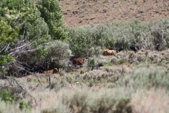
9 Horse Canyon, cattle in picture Davis Canyon: 9
 last year Davis Canyon, cattle days of")

10 Davis Canyon, area pre this year grazing showing cattle damage (feces age) last year Davis Canyon, cattle days of arrival eating new willow growth in riparian area Davis Canyon, cattle arrive in 103 degree heat to riparian area 10
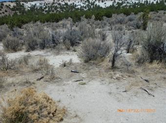
11 Corta 11


12 Corta Band noted at water source, sufficient water present in proportion to current horse sign 12


13 Walters Canyon, other wildlife present including bird, reptile and mammal. Significant horse population, in good health, observed and estimated by sign. Walters 13


14 Walters. Prior years damage showing sigs of regeneration regardless of current drought and horse populations. Horse Jumps in drift fence. On high side represent over 3.5 ft high and about 3 ft. wide. Wire covering over rock has openings (if horses did make attempt) large enough to catch hooves and create significant injury risk. 14

15 Horse Jump in fence line. Note: Assessments included observation of available forage, water and feces transects. Movement during current year may be impacted by drought. Areas of water hauling for domestic livestock show severe overuse of surrounding areas due to drought. Full report will be completed after further assessment. 15
FINAL Drought Monitoring 2013 WildHorseEducation.org
 FINAL Drought Monitoring 2013 WildHorseEducation.org Battle Mountain District, Bureau of Land Management (BLM) Background Identified Programmatic Challenges Identified Priority Ranges, Tonopah Field Station,
The Lake Creek Ranch. Located in the foothills of the Owl Creek Mountains in western Hot Springs County, Wyoming
 The Lake Creek Ranch Located in the foothills of the Owl Creek Mountains in western Hot Springs County, Wyoming Experienced Professional Ranch Brokers Specializing in the sale of ranches, farms, & recreational
Utah. North Stansbury Mountains Wilderness Study Area Site-Specific Monitoring Guide
 Utah North Stansbury Mountains Wilderness Study Area Site-Specific Monitoring Guide 1 General Information WildSNAP Monitoring Peter Woodruff, American Conservation Experience Coordinator Phone (801) 989-7069
Twin Peaks, New Ravendale, Buckhorn and Coppersmith Wild Horse and Burro Herd Management Areas Survey
 Twin Peaks, New Ravendale, Buckhorn and Coppersmith Wild Horse and Burro Herd Management Areas Survey October 24 th, 25 th and 26 th 2013 Craig C. Downer, Wildlife Ecologist, A.B., M.S., Ph.D. Candidature
Elko County Natural Resource Management Advisory Commission ELKO COUNTY NATURAL RESOURCE MANAGEMENT ADVISORY COMMISSION MINUTES
 Elko County Natural Resource Management Advisory Commission 540 COURT STREET, SUITE 104, ELKO, NV 89801 PH. (775)738-6816, FAX (775) 738-4581 ELKO COUNTY NATURAL RESOURCE MANAGEMENT ADVISORY COMMISSION
TWO FORKS RANCH A5 REAL ESTATE. 790 Acres. Smiths Fork - Lincoln County - Wyoming
 TWO FORKS RANCH 790 Acres Smiths Fork - Lincoln County - Wyoming A5 REAL ESTATE WWW.A5REALESTATE.COM QUICK FACTS Located in the upper Smiths Fork drainage of Lincoln County, Wyoming, the Two Forks Ranch
Re: 4720 P CAN050: Twin Peaks Gather Scoping Comments
 Bureau of Land Management Eagle Lake Field Office Dayne Barron Field Manager Eagle Lake Field Office 2950 Riverside Dr Susanville, CA 96130 March 5, 2010 Re: 4720 P CAN050: Twin Peaks Gather Scoping Comments
Sinbad Wild Burro Gather Utah (Day 1)
") Sinbad Wild Burro Gather Utah (Day 1) DATE: 11 April 2016 LOCATION: Temple Mountain Road (Exit 131) and I-70 BURROS GATHERED: 23 INTRODUCTION: Yesterday, I traveled to the small town of Green River, Utah
Sinbad Wild Burro Gather Utah (Day 1) DATE: 11 April 2016 LOCATION: Temple Mountain Road (Exit 131) and I-70 BURROS GATHERED: 23 INTRODUCTION: Yesterday, I traveled to the small town of Green River, Utah
DEVIL S GARDEN PLATEAU WILD HORSE TERRITORY
 DEVIL S GARDEN PLATEAU WILD HORSE TERRITORY EVALUATION OF MONITORING DATA FOR THE PURPOSE OF DETERMINING AN APPROPRIATE MANAGEMENT LEVEL Pacific Southwest Region Devil s Garden and Doublehead Ranger Districts
FEATURED NEWS. Greater Sage Grouse Habitat. View Web Version Like Tweet Forward
 View Web Version Like Tweet Forward FEATURED NEWS Greater Sage Grouse Habitat By: Terry Fieseler, Broker Traveling through the Rocky Mountain West, the untrained eye might gaze across the seemingly endless
A Risk-based Audit of the Captive/Privatelyowned Cervid Industry in Michigan
 A Risk-based Audit of the Captive/Privatelyowned Cervid Industry in Michigan Michigan Department of Natural Resources Report Series Issue Report No. 1 March 10, 2005 5.1.2 C/P-OC facility management 5.1.2.1
United States Department of the Interior Bureau of Land Management Ely Field Office May 2007
 United States Department of the Interior Bureau of Land Management Ely Field Office May 2007 Jakes Wash Herd Management Area Wild Horse Gather Plan and Final Environmental Assessment Introduction NV 040-07-EA-045
Subject to sale, withdrawal, or error.
 We are privileged to have the exclusive listing on a very scenic ranch in the beautiful western foothills of the Jemez Mountains in the northwest central area of New Mexico. This outstanding offering is
To be completely fair to the BLM, they do provide resources to aid in watering and feeding horses when. Page 3 of 8
 Testimony of Julian Joseph (J.J.) Goicoechea on behalf of Public Lands Council, National Cattlemen s Beef Association, and Nevada Cattlemen s Association Challenges and Potential Solutions for BLM s Wild
NEVADA DEPARTMENT OF WILDLIFE STATEWIDE FISHERIES MANAGEMENT
 NEVADA DEPARTMENT OF WILDLIFE STATEWIDE FISHERIES MANAGEMENT FEDERAL AID JOB PROGRESS REPORTS F-20-52 2016 REDBAND TROUT EASTERN REGION NEVADA DEPARTMENT OF WILDLIFE, FISHERIES DIVISION ANNUAL JOB PROGRESS
HOLT MOUNTAIN RANCH GLENWOOD, NEW MEXICO 74.4 (15.7 IRRIGATED) DEEDED ACRES 15,722 USFS ACRES
 DEEDED ACRES 15,722 USFS ACRES") HOLT MOUNTAIN RANCH GLENWOOD, NEW MEXICO 74.4 (15.7 IRRIGATED) DEEDED ACRES 15,722 USFS ACRES Offered Exclusively By Chas S. Middleton and Son, LLC www.chassmiddleton.com 1507 13th Street Lubbock, Texas
HOLT MOUNTAIN RANCH GLENWOOD, NEW MEXICO 74.4 (15.7 IRRIGATED) DEEDED ACRES 15,722 USFS ACRES Offered Exclusively By Chas S. Middleton and Son, LLC www.chassmiddleton.com 1507 13th Street Lubbock, Texas
The Heber-Reno Domestic Sheep Driveway and Management of Bighorn Sheep in Arizona.
 The Heber-Reno Domestic Sheep Driveway and Management of Bighorn Sheep in Arizona. The driveway occurs on 60 miles of the Apache Sitgreaves National Forest and 80 miles of the Tonto National Forest. The
Fish Creek Special Edition
 Fish Creek Special Edition FISH CREEK A Letter From WHE At Wild Horse Education, we work every day to create options that will build a better tomorrow for America s wild horses and burros. Fish Creek is
Northern California/Nevada Border. Twin Peaks Wild Horse and Burro. Herd Management Area. Aerial Population Survey. November 26 th 2013
 Northern California/Nevada Border Twin Peaks Wild Horse and Burro Herd Management Area Aerial Population Survey November 26 th 2013 Craig C. Downer, Wildlife Ecologist Jesica Johnston, Environmental Scientist
Environmental Assessments (WY)
") Utah State University DigitalCommons@USU Environmental Assessments (WY) Wyoming 2009 Wild Horse Gathering for the Red Desert Complex Wild Horse Herd Management Areas (Lost Creek, Stewart Creek, Green Mountain,
Utah State University DigitalCommons@USU Environmental Assessments (WY) Wyoming 2009 Wild Horse Gathering for the Red Desert Complex Wild Horse Herd Management Areas (Lost Creek, Stewart Creek, Green Mountain,
NEVADA DEPARTMENT OF WILDLIFE STATEWIDE FISHERIES MANAGEMENT
 NEVADA DEPARTMENT OF WILDLIFE STATEWIDE FISHERIES MANAGEMENT FEDERAL AID JOB PROGRESS REPORT F-20-50 2014 LAHONTAN CUTTHROAT TROUT STUDY WESTERN REGION NEVADA DEPARTMENT OF WILDLIFE, FISHERIES DIVISION
The Value of Springs to The Petersen Ranch
 The Value of Springs to The Petersen Ranch Location 60 miles SW of Austin 50 miles North of San Antonio 12 miles West of Blanco 18 miles SE of Fredericksburg 8 miles SW of Luchenbach Ranch Overview 800
Final Review of New Information Appendix E AMPs-Sheep Allotments in Gravelly Mountains. c,llorttarta 'Fisft, MADISON RANGER DISTRICT.
 RECEIVED + MAR 2 2 2017 c,llorttarta 'Fisft, MADISON RANGER DISTRICT J'Wi e 1400 South 19 th Avenue Bozeman MT 59718-5495 March 20, 2017 Dale Olsen Madison Ranger District 5 Forest Service Road Ennis,
WILDLIFE HERITAGE TRUST ACCOUNT PROJECT PROPOSAL FORM
 APPLICANT INFORMATION WILDLIFE HERITAGE TRUST ACCOUNT PROJECT PROPOSAL FORM Person/Organization/Agency Nevada Department Of Wildlife (NDOW) Name Mike Cox Title Big Game Staff Biologist Address 1 4600 Kietzke
Page 1. To: City of Durango - Parks and Recreation Advisory Board - Natural Lands Preservation Advisory Board Highland Avenue Durango, Colorado
 Page 1 To: City of Durango - Parks and Recreation Advisory Board - Natural Lands Preservation Advisory Board From: John Norton 2009 Highland Avenue Durango, Colorado Date: October 27, 2014 Regarding: Natural
San Gabriel River Ranch 240 ACRES FOR SALE IN WILLIAMSON COUNTY
 San Gabriel River Ranch 240 ACRES FOR SALE IN WILLIAMSON COUNTY Aerial Map Lake Belton Ranch DESCRIPTION: WATER OVERVIEW: Available for the first time in over 100 years, this is a rare opportunity to own
Patton Ranch. Colorado - Fremont County - Cañon City
 The Patton Ranch is a classic 10,000-acre Colorado cattle and hunting ranch (1,088 acres fee ownership, just over 9,000 acres BLM leases plus some private leased land) that is available for purchase for
MCDERMITT, NEVADA OREGON-NEVADA BORDER
 ZIMMERMAN RANCH MCDERMITT, NEVADA OREGON-NEVADA BORDER The Zimmerman Ranch is located approximately 15 air miles directly west of the community of McDermitt, Nevada. The ranch straddles the Nevada Oregon
Lesson Two. The Horses We All Own - The Wild Horse & Burro Program. Lessons about the Unwanted Horse. Teacher Guide and Resources: Goals
 Lessons about the Unwanted Horse The Horses We All Own - The Wild Horse & Burro Program Content explores government ownership of horses, the Wild Horse and Mustang Program (Description of current state
Deer Management Unit 122
 Deer Management Unit 122 Area Description DMU 122 is located in south Dickinson County and includes a small portion of west central Menominee County. It encompasses 163 sq. miles and has remained unchanged
placed on the market.
 With Mimbres River frontage and tremendous grass forage, this jewel in New Mexico s Southern Gila Region is a must have for the discriminating buyer looking to have it all in one easily operated grazing
Chapter 5 FUNCTIONAL CLASSIFICATION
 Chapter 5 FUNCTIONAL CLASSIFICATION Functional classification is a system by which streets and roadways may be distinguished by types according to their function within the entire transportation network.
B A G G S, W Y O M I N G - C R A I G, C O L O R A D O
 B A G G S, W Y O M I N G - C R A I G, C O L O R A D O Rockin J Ranch The Rockin J Cattle Ranch is located on the Little Snake River just west of Baggs, Wyoming, with land straddling either side of the
- Ranch - Bat tle mountain, NEVADA
 Bat tle mountain, NEVADA Operations Ranch does not own cattle, but rents pasture to several entities on a year to year basis. Maintaining the maximum carrying capacity of 6 AUMs, Ranch currently grazes
Split Rock Ranch q. Wyoming - Carbon, Fremont and Natrona County - Muddy Gap 1
 Approximately 200,000 total acres with 12 miles of the Sweetwater River, Split Split Rock Ranch with rolling grasslands and irrigated meadows. There are three sets of improve- Rock Ranch is located in
Cross F & Diamond Ranches Sunflower, Maricopa County, AZ
 Sunflower, Maricopa County, AZ Offered for sale exclusively by: Paul Groseta Headquarters West Ltd. 51 Verde Heights Drive, Suite A P.O. Box 1840 Cottonwood, AZ 96326 Phone: (928) 634-8110; Fax (928) 634-2113;
PARADISE CANYON RANCH
 PARADISE CANYON RANCH 4,413 Acres Lost Creek - Morgan County - Utah A5 REAL ESTATE WWW.A5REALESTATE.COM A5 REAL ESTATE 2 Paradise Canyon Ranch QUICK FACTS Located in upper Lost Creek, Morgan County, Utah
BRENT N. LONNER, Montana Fish, Wildlife & Parks, Fish & Wildlife Division, PO Box 488, Fairfield, MT 59436, USA
 History of Bighorn Sheep in the Sun River Area, Montana BRENT N. LONNER, Montana Fish, Wildlife & Parks, Fish & Wildlife Division, PO Box 488, Fairfield, MT 59436, USA Abstract: The Sun River bighorn sheep
A Comparison of Western Watershed Councils. Presentation Prepared by Jeff Salt, Great Salt Lakekeeper
 A Comparison of Western Watershed Councils Presentation Prepared by Jeff Salt, Great Salt Lakekeeper Presentation Overview Introduction Jordan River Watershed Council Lower Boise Watershed Council Clackamas
Albany County, Wyoming
 Albany County, Wyoming Western Land Sales 123 South 12th Street Thermopolis, WY 82443 www.westernland.net Roy Ready 307-234-2211 J.R. Kvenild 307-259-5000 China Wall Ranch Albany County, WY LOCATION &
Pre-Application Document Kaweah Project (FERC Project No. 298)
") TABLE OF CONTENTS Page 3.12 Aesthetic Resources... 3.12-1 3.12.1 Information Sources... 3.12-1 3.12.2 Setting... 3.12-1 3.12.3 Project Facilities... 3.12-2 3.12.4 Previous Visual Resources Assessment...
TABLE OF CONTENTS Page 3.12 Aesthetic Resources... 3.12-1 3.12.1 Information Sources... 3.12-1 3.12.2 Setting... 3.12-1 3.12.3 Project Facilities... 3.12-2 3.12.4 Previous Visual Resources Assessment...
STEELHEAD SURVEYS IN OMAK CREEK
 STEELHEAD SURVEYS IN OMAK CREEK 2002 Annual Report Prepared by Chris Fisher John Arterburn Colville Confederated Tribes Fish and Wildlife Department P.O. Box 150 Nespelem, WA 99155 Prepared for Project
Wild Horse Tourism in NM
 Wild Horse Tourism in NM How the Jicarilla Ranger District of the Carson National Forest can utilize the Jicarilla Wild Horses Territory (JWHT) for Eco-Tourism, Rural Economic Development, Preservation
BUFFALO PEAKS ELK MANAGEMENT PLAN EXTENSION
 BUFFALO PEAKS ELK MANAGEMENT PLAN EXTENSION DATA ANALYSIS UNIT E-22 GAME MANAGEMENT UNITS 49, 57, 58 November 2017 Jamin Grigg, Wildlife Biologist Colorado Parks and Wildlife 7405 Highway 50 Salida, CO
Subject to sale, withdrawal, or error.
 We are proud to offer for sale this long-term family ownership ranch located in northwestern Cottle County. The property is located northwest of Paducah in the central Rolling Plains and adjoins the 28,000
The. Established. Roger Jacobs (406) Bryan Anderson (406)
 Bryan Anderson (406)") The Diamond Ranch 1882 Established N ever before offered for sale, since the 1880 s, The Diamond Ranch has been owned by five generations of the same family. This is the opportunity of a lifetime to own
The Diamond Ranch 1882 Established N ever before offered for sale, since the 1880 s, The Diamond Ranch has been owned by five generations of the same family. This is the opportunity of a lifetime to own
Management History of the Edwards Plateau
 Management History of the Edwards Plateau Eco regions of Texas Edwards Plateau 24,000,000 acres About 15,000 years ago, the Edwards Plateau was much cooler and was more forested than today. Pollen counts
Competition. Competition. Competition. Competition. Competition. Competition. Competition. Long history in ecology
 Two species use the same limited resource or harm one another while seeking a resource Resource Organisms use common resources that are in short supply Resource Interference Interference Organisms seeking
H. R. To provide for the protection of the last remaining herd of wild and genetically pure American Buffalo. IN THE HOUSE OF REPRESENTATIVES A BILL
 F:\M\HINCHE\HINCHE_0.XML... (Original Signature of Member) TH CONGRESS ST SESSION H. R. To provide for the protection of the last remaining herd of wild and genetically pure American Buffalo. IN THE HOUSE
Starlite Ranch INTERMOUNTAIN REALTY GROUP S Holladay Blvd., Salt Lake City, Utah,
 Starlite Ranch Millard County, Utah 960 Acres $795,000 INTERMOUNTAIN REALTY GROUP 4571 S Holladay Blvd., Salt Lake City, Utah, 84117 801-277-0800 www.intermountainrealtygroup.com Welcome to Starlite Ranch
Factors Influencing Cattle, Elk, and Mule Deer Distribution in Managed Forests
 Factors Influencing Cattle, Elk, and Mule Deer Distribution in Managed Forests Marty Vavra SUMMARY Intensive research involving elk, mule deer, and cattle has been conducted on the Starkey Experimental
CHECKS AND BALANCES. OVERVIEW Students become managers of a herd of animals in a paper-pencil, discussionbased
 CHECKS AND BALANCES 5 OVERVIEW Students become managers of a herd of animals in a paper-pencil, discussionbased activity. BACKGROUND White Tailed Deer White-tailed deer have always been a part of the forest
$1,850, CASH. NOUQUE RANCH McDERMITT, NV DEEDED ACRES IN OREGON IN NEVADA HUGE BLM PERMIT OVER 330,000 ACRES
 64347 HARNEY AVE. CRANE, OR 97732 1611.65 DEEDED ACRES 676.87 IN OREGON 934.78 IN NEVADA HUGE BLM PERMIT OVER 330,000 ACRES NOUQUE RANCH McDERMITT, NV 584.37 ACRES OF PRIMARY WATER RIGHTS TWO HOMES MULTIPLE
WADE WEST INCENTIVE TAGS 2016 NDOW- REPORTING BIOLOGIST SCOTT ROBERTS
 WADE WEST INCENTIVE TAGS 2016 NDOW- REPORTING BIOLOGIST SCOTT ROBERTS PROGRAM OVERVIEW As you are all aware, the difficulty of this program is that a large portion of it is subjective. It is not based
HORSES AND BURROS: OVERVIEW
 NATIONAL HORSE & BURRO RANGELAND MANAGEMENT COALITION Advocating for commonsense, ecologically-sound approaches to managing horses and burros to promote healthy wildlife and rangelands for future generations
JULY 2017 SUMMARY BULLETS
 FY 2017 Predator Report Appendix Project 21-02 Comments To: From: NV Department of Wildlife, Bureau of Land Management U.S. Geological Survey, WERC Research Team Subject: March July 2017 Progress Update
YELLOWSTONE RANCH PRESERVE HEBGEN LAKE, MONTANA
 YELLOWSTONE RANCH PRESERVE HEBGEN LAKE, MONTANA PROPERTY OVERVIEW CONTENTS: PROPERTY OVERVIEW...3 CONSERVATION EASEMENT...5 WHISKEY JUG CABIN...6 THE MARINA...7 MAP...8 WILDLIFE...10 YELLOWSTONE REGION...11-3
Commentary Managing healthy wild horses and burros on healthy rangelands: tools and the toolbox
 Human Wildlife Interactions 12(1):143 147, Spring 2018 Commentary Managing healthy wild horses and burros on healthy rangelands: tools and the toolbox C H, White River & Douglas Creek Conservation Districts,
ARIKAREE DEER HERD MANAGEMENT PLAN
 ARIKAREE DEER HERD MANAGEMENT PLAN DATA ANALYSIS UNIT D-55 Game Management Units 101 & 102 January 2006 Marty Stratman Colorado Division of Wildlife Terrestrial Biologist 122 E. Edison St. Brush, CO 80723
Saint John's Abbey Arboretum Controlled Deer Hunt 2013
 Saint John's Abbey Arboretum Controlled Deer Hunt 2013 Welcome to Saint John s for the 12th controlled deer hunt since 1933. 17 July 2013 The following rules apply to all hunters allowed on Saint John
Report to the Joint Standing Committee on Inland Fisheries and Wildlife
 Report to the Joint Standing Committee on Inland Fisheries and Wildlife As Required by 12 Section 10107-A White-tailed Deer Population Management Written By: Wildlife Management Staff, Inland Fisheries
Bureau of Land Management White River Field Office Attention: Melissa Kindall 220 East Market Street Meeker, Colorado 81641
 Bureau of Land Management White River Field Office Attention: Melissa Kindall 220 East Market Street Meeker, Colorado 81641 Re: CO-110 (WRFO) 4700 DOI-BLM-CO-110-2010-0088 Wild Horse Removal Plan July
TITLE 35. OKLAHOMA DEPARTMENT OF AGRICULTURE, FOOD, AND FORESTRY CHAPTER 15. ANIMAL INDUSTRY SUBCHAPTER 34. FERAL SWINE
 TITLE 35. OKLAHOMA DEPARTMENT OF AGRICULTURE, FOOD, AND FORESTRY CHAPTER 15. ANIMAL INDUSTRY SUBCHAPTER 34. FERAL SWINE 35:15-34-1. Purpose The purpose of these rules is to implement the provisions of
Proposed 2018 Fisheries Management Measures to Support Recovery of Interior Fraser River Steelhead
 Proposed 2018 Fisheries Management Measures to Support Recovery of Interior Fraser River Steelhead 22-March-2018 Spawning escapements of two Interior Fraser River steelhead stocks, Thompson and Chilcotin
4. ENVIRONMENTAL IMPACT ANALYSIS 9. TRANSPORTATION AND TRAFFIC
 4. ENVIRONMENTAL IMPACT ANALYSIS 9. TRANSPORTATION AND TRAFFIC 4.9.1 INTRODUCTION The following section addresses the Proposed Project s impact on transportation and traffic based on the Traffic Study
A Sportsman's Guide to Landowner Relations
 MT 9813 Agriculture A Sportsman's Guide to Landowner Relations by Larry Brence, Fallon-Carter County Extension Agent and Jim Knight, Extension Wildlife Specialist Sportsmen have long enjoyed Montana as
P.O. Box 24 Joshua Tree, California July 16, 2015
 P.O. Box 24 Joshua Tree, California 92254 www.mbconservation.org July 16, 2015 CA Fish and Game Commission Sonke Mastrup, Executive Director 1416 Ninth Street, Room 1320 Sacramento, CA 95814 Submitted
Mule Deer. Dennis D. Austin. Published by Utah State University Press. For additional information about this book
 Mule Deer Dennis D. Austin Published by Utah State University Press Austin, D.. Mule Deer: A Handbook for Utah Hunters and Landowners. Logan: Utah State University Press, 2010. Project MUSE., https://muse.jhu.edu/.
PROTECTING SAGE GROUSE AND THEIR HABITAT IN THE WEST. John Harja Senior Counsel on Detail to the Public Lands Office
 PROTECTING SAGE GROUSE AND THEIR HABITAT IN THE WEST John Harja Senior Counsel on Detail to the Public Lands Office Chick Female (Hen) Male (Cock) Nest w eggs Lek Sage-grouse need sagebrush. Landscape-scale
SKINNER MEADOWS RANCH
 SKINNER MEADOWS RANCH JACKSON, MONTANA $3,999,000 I 885+/- ACRES LISTING AGENT: KEITH HANDLOS 10 WEST REEDER STREET DILLON, MT 59725 P: 406.683.2234 M:406.925.1814 KHANDLOS@BEAVERHEADHOMEANDRANCH.COM EXECUTIVE
APPENDIX 12 MANAGING WILD HORSE POPULATIONS IN THE RAWLINS RMPPA
 Final EIS Appendix 12 APPENDIX 12 MANAGING WILD HORSE POPULATIONS IN THE RAWLINS RMPPA The Bureau of Land Management (BLM) monitors wild horse populations to comply with population management objectives
FEDERAL ENERGY REGULATORY COMMISSION FIELD INSPECTION REPORT
 FIELD INSPECTION REPORT Date September 25 and 26, 2016 Project Kern River Gas Transmission Company (Kern River) Apex Expansion Project Utah, Millard, Beaver, Morgan, Davis, and Salt Lake Counties, Utah;
Hunting, Fishing, Recreational Shooting, and Wildlife Conservation Opportunities and Coordination with States, Tribes, and Territories
 THE SECRETARY OF THE INTERIOR WASHINGTON ORDER NO. 3356 Subject: Hunting, Fishing, Recreational Shooting, and Wildlife Conservation Opportunities and Coordination with States, Tribes, and Territories Sec.
Nebraska National Forests and Grasslands Bessey Ranger District Motorized Trail Width Project
 Nebraska National Forests and Grasslands Bessey Ranger District Motorized Trail Width Project Purpose and Need The purpose of this project is to improve motorized recreational opportunities by allowing
Compression Study: City, State. City Convention & Visitors Bureau. Prepared for
 : City, State Prepared for City Convention & Visitors Bureau Table of Contents City Convention & Visitors Bureau... 1 Executive Summary... 3 Introduction... 4 Approach and Methodology... 4 General Characteristics
ROCKWALL CENTRAL APPRAISAL DISTRICT
 ROCKWALL CENTRAL APPRAISAL DISTRICT WILDLIFE MANAGEMENT SPECIAL VALUATION GUIDELINES A SUPPLEMENT TO THE STATE OF TEXAS GUIDELINES FOR QUALIFICATION OF AG LAND IN WILDLIFE MANAGEMENT USE These guidelines
Interagency Special Status/Sensitive Species Program FY2005 Inventory & Conservation Planning Status Report
 Interagency Special Status/Sensitive Species Program FY2005 Inventory & Conservation Planning Status Report PROJECT TITLE: Crooked River National Grassland Pygmy Rabbit Habitat Assessment and Survey PROJECT
Youth Cow Elk and Doe Deer Hunts at Burns Hole -Ranching for Wildlife-
 Youth Cow Elk and Doe Deer Hunts at Burns Hole -Ranching for Wildlife- Bull Basin Outfitters in conjunction with the Burns Hole Ranching for Wildlife Program is proud to offer the Northern Colorado Chapter
Mining & Petroleum Focus Group Southern Rocky Mountain Management Plan. Synopsis of Focus Group Key Issues
 Southern Rocky Mountain Management Plan Page 1 of 6 Synopsis of Focus Group Key Issues Sectors who brought forth issues are listed after the issue in brackets. I. Timeline Completing the plan by June,
440+ Acres. Laramie Mountains Cow Camp Converse County, Wyoming Offered at $660,000
 LAND FOR SALE Serving America s Landowners Since 1929 440+ Acres Laramie Mountains Cow Camp Converse County, Wyoming Offered at $660,000 L-1600011 440+ deeded acres Texas Creek runs the full length of
LION MOUNTAIN RANCH JEFF DAVIS COUNTY. CHARLES M. DAVIDSON Partner/ Agent REPUBLICRANCHES.
 LION MOUNTAIN RANCH JEFF DAVIS COUNTY CHARLES M. DAVIDSON Partner/ Agent 210-415-5570 cmd@republicranches.com REPUBLICRANCHES.COM LION MOUNTAIN RANCH Lion Mountain Ranch, named for only one of the many
RANCHING Wildlife. Texas White-Tailed Deer 2017 Hunting Forecast
 RANCHING Wildlife Texas White-Tailed Deer 2017 Hunting Forecast During most summers, I take a short break and head to Colorado, Wyoming, or somewhere out west to enjoy a respite from the hot South Texas
O Bar O Ranch Graham County, Arizona
 O Bar O Ranch Graham County, Arizona Offered for sale exclusively by: Walter Lane Headquarters West, Ltd. 4582 N 1 st Avenue Tucson, AZ 85718 Telephone (520) 792-2652; Fax (520) 792-2629 www.headquarterswest.com
Lookout Mountain Ranch
 Lookout Mountain Ranch Daniel, Wyoming John Turner, Broker/Partner LiveWaterProperties.com Toll Free 866.734.6100 LOCATION: The Lookout Mountain Ranch is located 15 miles northwest of Daniel Junction in
BLACK GAP WMA/ECLCC MULE DEER RESTORATION PROJECT UPDATE. February 2, 2016
 //CEMEX USA BLACK GAP WMA/ECLCC MULE DEER RESTORATION PROJECT UPDATE February 2, 2016 Mule deer numbers at Black Gap Wildlife Management Area (BGWMA) and El Carmen Land & Conservation Company-CEMEX USA
West District Bison Relocation Summary
 West District 2010 Bison Relocation Summary Overview and Statistics Westside bison operations began on May 4, 2010 and ended on June 21, 2010. Twenty-two separate operations were conducted requiring 993
Resources Update 2018 Tri-RAC
 Resources Update 2018 Tri-RAC National Monuments Basin and Range 704,000 acres Gold Butte 300,000 acres National Monuments, National Conservation Areas and Wilderness National Conservation Areas Red Rock
APPENDIX 12 MANAGING WILD HORSE POPULATIONS IN THE RAWLINS RMPPA
 APPENDIX 12 MANAGING WILD HORSE POPULATIONS IN THE RAWLINS RMPPA The Bureau of Land Management (BLM) monitors wild horse populations to comply with population management objectives set in the land use
Transition: Wild Horse & Burro Management
 Horses and Burros (Thousands) NATIONAL HORSE & BURRO RANGELAND MANAGEMENT COALITION Advocating for commonsense, ecologically-sound approaches to managing horses and burros to promote healthy wildlife and
Wildlife Introduction
 Wildlife Introduction The wildlife section of this chapter is divided into sections for various habitats and groups of species. Old growth, snags and downed wood, and riparian areas are unique habitats
Sheep Producers Are Challenged By Enviros Over Bighorn Issue
 September 21, 2011 Livestock Weekly, Texas Sheep Producers Are Challenged By Enviros Over Bighorn Issue By Colleen Schreiber MCCALL, Idaho Sheep belonging to the Soulen family have been grazing allotments
2017 LATE WINTER CLASSIFICATION OF NORTHERN YELLOWSTONE ELK
 2017 LATE WINTER CLASSIFICATION OF NORTHERN YELLOWSTONE ELK A collaborative survey by the Northern Yellowstone Cooperative Wildlife Working Group Report Prepared by: Karen Loveless, Montana Fish Wildlife
Controlled Take (Special Status Game Mammal Chapter)
") Controlled Take (Special Status Game Mammal Chapter) Background of issue: The current Plan contains standards including the use of controlled take as a management response tool to assist in some situations
Controlled Take (Special Status Game Mammal Chapter) Background of issue: The current Plan contains standards including the use of controlled take as a management response tool to assist in some situations
CONNECTING COMMUNITIES THROUGH TRAILS
 CONNECTING COMMUNITIES THROUGH TRAILS CONNECTING COMMUNITIES THROUGH TRAILS Create a master trails plan Connect communities to each other Connect communities to Deseret Peak Complex Access to a maintained
DMU 043 Lake County Deer Management Unit
 DMU 43 Lake County Deer Management Unit Area Description Lake County Deer Management Unit is in the Northern Lower Peninsula Region (NLP). It has approximately 2, acres of public land which is about half
ORDINANCE NO. WHEREAS, the feeding of wildlife can lead to negative impacts on animals, people and the environment; and
 ORDINANCE NO. AN ORDINANCE OF THE CITY COUNCIL OF THE CITY OF DAVIS ADDING ARTICLE 5.05 TO CHAPTER 5 OF THE DAVIS MUNICIPAL CODE TO PROHIBIT THE FEEDING OF CERTAIN WILDLIFE WHEREAS, the City of Davis (
CHEETAH PROJECT Cheetah Conservation Fund. Interviewers name Date
 CHEETAH PROJECT Cheetah Conservation Fund Interviewers name Date 1. Interviewee: Name: Occupation Owner, Manager, Ranger, Farm employee, Other Age (yrs) Male Female For how long have you worked on this
Peace Region Wildlife Regulations Proposed Changes for Comment ( )
") Peace Region Wildlife Regulations Proposed Changes for Comment (2010-11) INTRODUCTION This document summarizes changes to hunting regulations currently under consideration in the Peace Region. These changes,
Peace Region Wildlife Regulations Proposed Changes for Comment (2010-11) INTRODUCTION This document summarizes changes to hunting regulations currently under consideration in the Peace Region. These changes,
The Cerf Pasture is located about 30 miles southeast of Fort Stockton, Texas on the east side of US Highway 285.
 We are proud to offer for sale the Cerf Pasture, which is the eastern portion of the massive Longfellow Ranch. The Longfellow Ranch is a very well known and widely recognized West Texas Ranch comprising
Cloverdale Ranch 1, /- Acres Fannin County, Texas $3,997,116 ($2,695/acre) Office: (214)
 Office: (214)") 1,483.16+/- Acres Fannin County, Texas $3,997,116 ($2,695/acre) Office: (214) 361-9191 Fannin County, Texas 1483.16 +/- Acres LOCATION: Historic Cloverdale Ranch is located in northwest Fannin County with
1,483.16+/- Acres Fannin County, Texas $3,997,116 ($2,695/acre) Office: (214) 361-9191 Fannin County, Texas 1483.16 +/- Acres LOCATION: Historic Cloverdale Ranch is located in northwest Fannin County with