MOOSE SURVEY RACKLA AREA LATE-WINTER Prepared by: Mark O'Donoghue, Joe Bellmore, Sophie Czetwertynski and Susan Westover
|
|
|
- Natalie May
- 5 years ago
- Views:
Transcription


1 MOOSE SURVEY RACKLA AREA LATE-WINTER 2013 Prepared by: Mark O'Donoghue, Joe Bellmore, Sophie Czetwertynski and Susan Westover October 2013
2 MOOSE SURVEY RACKLA AREA LATE-WINTER 2013 Yukon Department of Environment Fish and Wildlife Branch TR Acknowledgments The Yukon Environmental and Socio-economic Assessment Board provided funding and Yukon Environment provided staff to conduct this survey. The First Nation of Na-Cho Nyäk Dun also provided staff for several days. We thank Sidney Goldschmidt and Kevin Veldhuis for safe, efficient flying in often difficult conditions. Heather Milligan did a fine job as crew leader and navigator for several days of this survey. We also thank Debbie Buyck, Gaetan Cyr, Taylor Ewing, Jimmy Johnny, Liz MacDonald, Bruce MacGregor, Ronald Peter, Pat Van Bibber, and Adam Wrench for providing their keen eyesight and knowledge of the area as observers on the aerial survey crews Yukon Department of Environment Copies available from: Yukon Department of Environment Fish and Wildlife Branch, V-5A Box 2703, Whitehorse, Yukon Y1A 2C6 Phone (867) , Fax (867) environmentyukon@gov.yk.ca Also available online at Suggested citation: O DONOGHUE, M., J. BELLMORE, S. CZETWERTYNSKI, AND S. WESTOVER Moose Survey: Rackla area, late winter Yukon Fish and Wildlife Branch Report TR Whitehorse, Yukon, Canada.
3 Summary We conducted a late-winter survey of moose in the Beaver, Rackla, and Nadaleen river watersheds along the upper Stewart River on 2-7 March 2013, using helicopters. The main purpose of this survey was to map the distribution and late-winter habitats of moose in this area. We flew over the entire survey area and spent about 0.56 minutes per km² searching for moose. We found a total of 389 moose, of which 358 were adults and 31 were calves. Moose were widely distributed across the survey area. Most were concentrated in valleys of the rivers and major creeks in willow-rich habitats with shallower snow depths than in the adjacent subalpine areas. Lower-altitude areas burned in the 1970s through 1990s with abundant willows were heavily used. Some moose were found in subalpine willow habitats especially in the upper Beaver River watershed in the west of the survey area, where snow depths were lower than in subalpine habitats further east. About 8% of moose seen in the survey were calves. This may be negatively biased because of lower sightability of cows with calves. It is, however, fairly low compared to other late-winter surveys of this type, indicating that recruitment was likely below average this year in this area. We also observed a concentration of caribou in the upper Rackla and East Rackla river watersheds, in an area that is south of the mapped range of the adjacent Bonnet Plume caribou herd. Rackla Area Late-Winter Moose Survey - March 2013 i
4 Table of Contents Acknowledgments... inside cover Summary... i Table of Contents... ii List of Maps... ii List of Tables... ii Introduction... 1 Previous Surveys... 1 Community Involvement... 1 Study Area... 1 Methods... 3 Weather and Snow Conditions... 3 Results and Discussion... 3 Coverage... 3 Observations of Moose... 5 Distribution of Moose... 5 Ages of Moose... 5 Identification of High and Low-Density Blocks... 6 Other Wildlife Sightings... 6 Conclusions and Recommendations Literature Cited List of Maps MAP 1. March 2013 Rackla Area Moose Survey.2 MAP 2. Rackla Area Fire History MAP 3. Moose Observations Rackla Area MAP 4. Survey Block Stratification Rackla Area....8 MAP 5. Caribou Observations Rackla Area List of Tables TABLE 1-Observations of moose during the March 2013 survey in the Rackla area Rackla Area Late-Winter Moose Survey - March 2013 ii
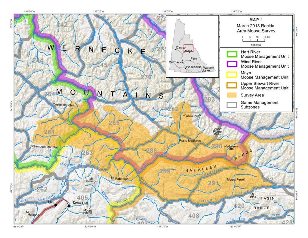
5 Introduction This report summarises the results of the late-winter survey of moose in the Beaver, Rackla, and Nadaleen river watersheds along the upper Stewart River (see Map 1), conducted 2-7 March The survey included parts of the Mayo, Hart River, Wind River, and Upper Stewart River Moose Management Units. The main purpose of the survey was to map the distribution and late-winter habitats of moose in this area, which is experiencing high levels of mineral exploration and the proposed development of an operating mine and new access road. Previous Surveys Environment Yukon has not previously surveyed moose in this area. Community Involvement This survey was conducted because of the high level of mining exploration and staking in this area, and the resulting concerns expressed by residents of the Mayo area about cumulative effects on wildlife during planning sessions for developing the Community-based Fish and Wildlife Management Work Plan for the Na-Cho Nyäk Dun Traditional Territory for This plan was developed cooperatively by the Mayo District Renewable Resources Council, the First Nation of Na-Cho Nyäk Dun, and the Yukon Fish and Wildlife Branch. The First Nation of Na-Cho Nyäk Dun provided staff to help conduct the survey. Study Area The 6,069 km² survey area was delineated to cover the Beaver and Rackla river watersheds, and the lower Nadaleen River watershed, which are all tributaries to the upper Stewart River (see Map 1). This area was selected because virtually all alpine and subalpine habitats in the region were staked with hard-rock mineral claims in the late 2000s and early 2010s, and we have very few relevant baseline wildlife data to use in assessing development proposals here. The study area consisted mostly of rugged terrain, much of it above treeline, in the southern Wernecke Mountains. The highest peaks in this range are between 2,000 and 2,740 metres above sea level. The Beaver, Rackla, and Nadaleen rivers flow south into the Stewart River which is the southeastern boundary of the survey area (see Map 1). Much of the area is alpine tundra and exposed rock, with subalpine willow and birch shrub habitats on lower slopes. Black and white spruce forest, mixed in places with poplar, aspen, and birch, are found in the main river and creek valleys and on lower slopes (see Smith et al for a full description of the area s vegetation, landforms, and geology). The survey area is remote, with no year-round ground-based access routes. Mineral staking and exploration have greatly increased the amount of industrial human activity in the area since the mid- 2000s. Rackla Area Late-Winter Moose Survey - March
6
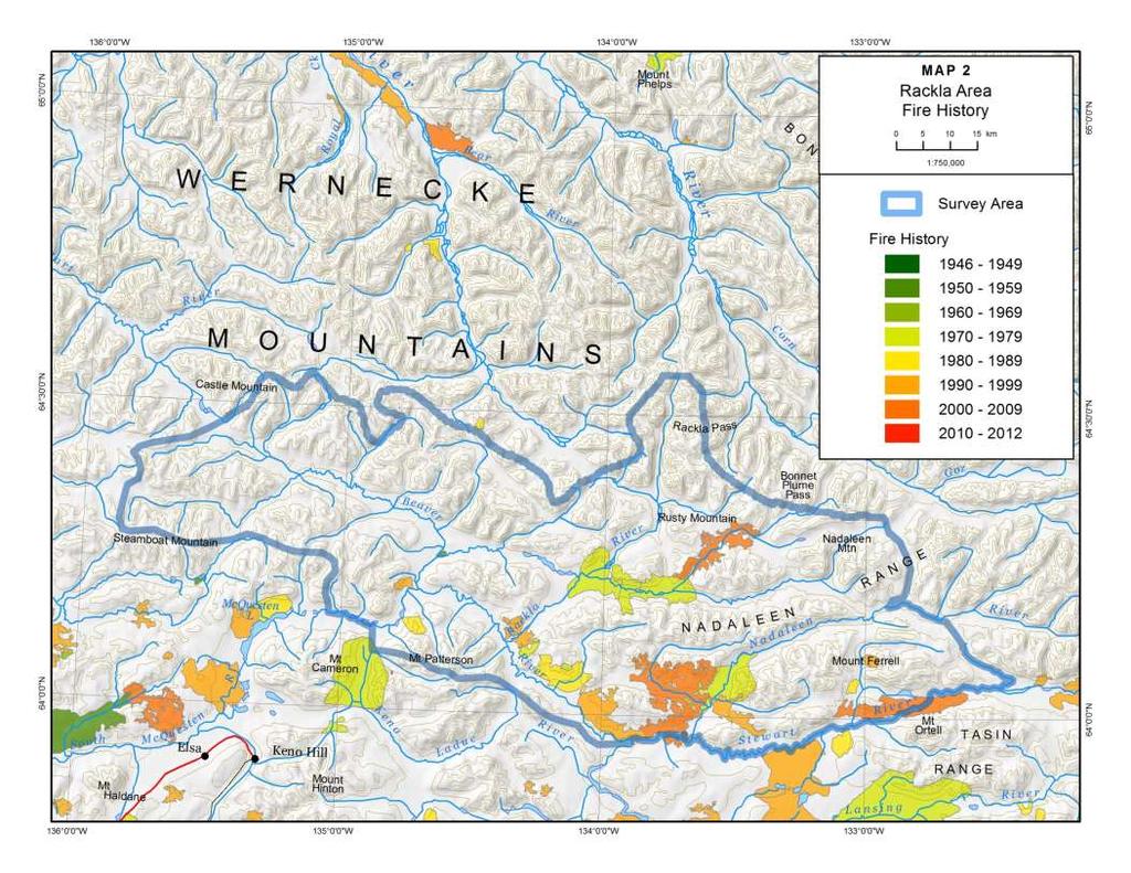
7 Most of the area is unburned, but there are several old and recent burns mostly in the east (see Map 2), and these vary in quality as moose habitat. The largest fires were the 130 km² 2004 burn and 102 km² 1972 burn along the lower Nadaleen River, the 124 km² burns in the Rackla River watershed, and the 62 km² 2006 burn along the Stewart River north of Mount Ortell. Methods We used a survey method called intensive stratification, which gives us good information about the distribution and areas of concentration of moose over the entire survey area. The technique involves the following steps: 1. The survey area is divided into uniform rectangular blocks km² (2' latitude x 5' longitude) in size. 2. Observers in aircraft fly over all the blocks, making about 4 passes through each block and classifying (or stratifying ) them as having either high, medium, low, or very low expected moose abundance, based on local knowledge, number of moose seen, tracks, and habitat. This is the same as the stratification part of a full moose census survey, except that we cover the area at about four times the intensity (0.5 minutes per km²) to get more complete information. 3. We count and get a GPS location of each moose or group of moose we see. We classify all moose seen by age (adult or calf) when possible, but we do not put as much effort into this as we do during censuses when we are making estimates of population composition. With the exception of cows with calves, we do not try to determine the sex of moose. For this survey, we also recorded a GPS location for each sighting of fresh moose tracks, in order to supplement our data from animal observations. Weather and Snow Conditions Weather conditions for this survey were mixed. Temperatures ranged from -28 C to -8 C. Skies were mostly cloudy with some snow for the first 3 days of the survey, and we had difficulty getting into higher-elevation areas because of low clouds. It was mostly clear for the last half of the survey. Winds were light to moderate and presented no problems. Light conditions ranged from flat to bright and snow coverage was complete, so visibility was generally good for spotting moose. Results and Discussion Coverage It took us about 56.7 hours to count moose in the 404 blocks in the survey area, for a search intensity of 0.56 minutes per km². This is slightly higher than our target search intensity of 0.5 minutes per km², and corresponded with flying through each block about 4 times and circling animals when needed to verify sightings. We needed an additional 23.0 hours to ferry to and from the survey area and fuel supplies in Mayo and on airstrips in the survey area. The time devoted to ferrying was about 29% of the total flight time. Rackla Area Late-Winter Moose Survey - March
8
9 Table 1-Observations of moose during the March 2013 survey in the Rackla area. Number Observed Percentage of Moose Observed Adults Calves 31 8 Observations of Moose We counted a total of 389 moose; 358 of them were adults and 31 were calves (see Table 1). We spent 3,403 minutes searching the survey blocks for moose, so we saw an average of 0.11 moose per minute of survey time. In addition to moose seen, we also noted fresh moose tracks at 631 locations. Distribution of Moose Moose were widely distributed across the survey area (see Map 3). Most were concentrated in the valleys of the Beaver, Rackla, East Rackla, Nadaleen, and Stewart rivers and major creeks, in willow-rich habitats with shallower snow depths than in the adjacent subalpine areas. Loweraltitude areas burned in the 1970s through 1990s with abundant willows, especially along the lower Beaver, East Rackla, and lower Nadaleen rivers, were heavily utilised. Some moose were found in subalpine willow habitats, especially in the upper Beaver River watershed in the western part of the survey area where snow depths were lower than in subalpine areas further east. In the central Yukon, moose typically concentrate in river valleys during winters of deep snow, moving down from their preferred early-winter subalpine habitats when snow get too deep as the winter progresses (Fraser et al. 2001, O Donoghue 2005). Snowfall in the Rackla area was about average during the winter of (Yukon Department of Environment 2013). We opportunistically measured snow depths at 9 sites in the survey area; they ranged from 55 cm to 103 cm and averaged 77 cm. Snow depths were generally lowest in the western part of the survey area and at lower elevations. The average snow depths were greater than those that would negatively affect moose (above 70 cm; Peek 1997). Ages of Moose We classified all of the moose we saw by age, but we cannot translate these directly into estimates of the composition of the moose population in the study area. Stratification surveys such as this are aimed mostly at determining the distribution of moose in the survey area. The data are valuable for mapping important habitats and also for dividing up the survey blocks covering the area into strata or categories of high and low expected densities of moose for future late-winter surveys. The observed proportions of moose of different ages that we saw were likely biased compared to those of the actual population. Rackla Area Late-Winter Moose Survey - March
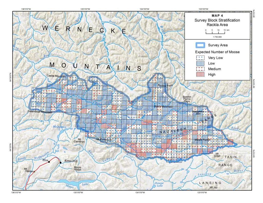
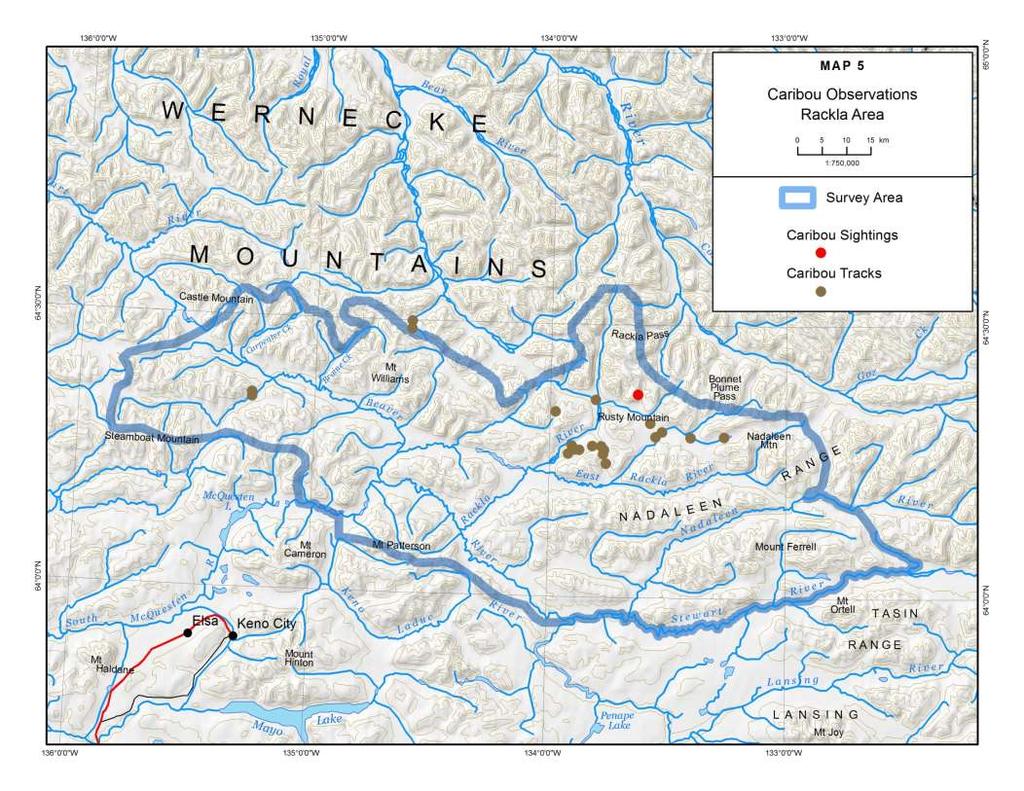
10 Previous surveys have shown that cow moose, particularly cows with calves, tend to space themselves away from other moose more than bulls do, so that there is a higher proportion of cows in low-density survey blocks than there is in high-density blocks. Low-density blocks also typically have lower sightability, because forest canopies are, on average, denser. As a result of these differences in sightability, we likely miss seeing more cows and calves than we do bulls when we search over all habitats with the same intensity, so our observations will be biased. Census surveys, in which survey blocks are searched more intensively and counts are corrected for sightability, are more appropriate for estimating population composition than are intensive stratification surveys. Our observed composition index was 8% calves in the population. Although likely biased low, 8% calves is also low compared to the percentage found in late-winter surveys of this type elsewhere in the Yukon (average of 11% calves observed), so it is likely that survival of calves to 10 months of age was fairly low in this area during the last year. The age classifications observed in this survey can be compared directly with the results from similar late-winter surveys in the future. Identification of High and Low-Density Blocks We divided the survey blocks into 4 categories of expected moose density, for use in future late-winter surveys of the area. We classified 28 (7%) of the 404 survey blocks as high, 88 (22%) as medium, 191 (47%) as low, and 97 (24%) as very low expected abundance of moose (see Map 4), based on our observations from the air. Most of the blocks with higher expected numbers of moose were located along the main river and creek valleys. Other Wildlife Sightings In addition to the 389 moose we counted in our survey blocks, we also observed 32 moose just outside the survey area boundary or during our ferries to fuel (included in Map 3). During the survey, we also recorded sightings of other notable wildlife besides moose and recorded the locations of caribou tracks. We saw 1 group of 6 caribou and 20 sites with caribou tracks, mostly concentrated around the upper Rackla and East Rackla rivers (see Map 5). This area is well south of the mapped winter range of the adjacent Bonnet Plume caribou herd, and it is uncertain if these animals are a part of that herd. Low numbers of caribou have been seen in this area during winter surveys since 2007 and are apparently resident here (O Donoghue 2013). We also spotted 2 sheep during this survey a young ram near Carpenter Creek and another just south of Mount Patterson. Rackla Area Late-Winter Moose Survey - March

11 Rackla Area Late-Winter Moose Survey - March
12
13
14 Conclusions and Recommendations Habitat with abundant willows along the main river and creek valleys supported the highest densities of moose in this area in late winter This area typically has relatively deep snow by late winter because southern storm systems tend to drop precipitation when they hit the Wernecke Mountains. Local knowledge indicates that moose in this area typically concentrate more in the larger river valleys by mid- to late winter. Recruitment of moose appears to have been fairly low in this area during the past year. These data provide a baseline on moose distribution and important habitats for use in environmental assessments and monitoring plans associated with development proposals. Before development of new access roads or operational mines proceeds in this area, we should gather a second year of baseline data on moose distribution to examine the amount of variation among years. Rackla Area Late-Winter Moose Survey - March
15 Literature Cited FRASER, V., M. O DONOGHUE, AND S. WESTOVER Mayo Moose Management Unit. Summary of late-winter 2001 moose survey. 2-5 March Yukon Fish and Wildlife Branch Report SR , Whitehorse, Yukon, Canada O DONOGHUE, M Late winter habitat use by moose: Survey of the Pelly and Macmillan river areas March Yukon Fish and Wildlife Branch Report SR , Whitehorse, Yukon, Canada. O DONOGHUE, M Habitat survey: Bonnet Plume caribou herd, late-winter Yukon Fish and Wildlife Branch Report TR-13-04, Whitehorse, Yukon, Canada. PEEK, J. M Habitat relationships. Pages in A. W. Franzmann and C. C. Schwartz, editors, Ecology and management of the North American moose; Smithsonian Institution Press, Washington D.C., United States. SMITH, C. A. S., J. C. MEIKLE, & C. F. ROOTS (EDITORS) Ecoregions of the Yukon Territory: Biophysical properties of Yukon landscapes. PARC Technical Bulletin No , Agriculture and Agri-food Canada, Ottawa, Canada. YUKON DEPARTMENT OF ENVIRONMENT Yukon snow survey bulletin and water supply forecast. March 1, Yukon Water Resources Branch, Whitehorse, Yukon, Canada. Rackla Area Late-Winter Moose Survey - March
MAYO MOOSE MANAGEMENT UNIT
 MOOSE SURVEY MAYO MOOSE MANAGEMENT UNIT LATE-WINTER 2014 Prepared by: Mark O'Donoghue, Joe Bellmore, Sophie Czetwertynski and Susan Westover July 2016 MOOSE SURVEY MAYO MOOSE MANAGEMENT UNIT LATE-WINTER
LITTLE SALMON AND MAGUNDY RIVERS
 MOOSE SURVEY LITTLE SALMON AND MAGUNDY RIVERS LATE-WINTER 2007 Prepared by: Mark O'Donoghue February 2013 MOOSE SURVEY LITTLE SALMON AND MAGUNDY RIVERS LATE-WINTER 2007 Yukon Department of Environment
MAYO MOOSE MANAGEMENT UNIT
 MOOSE SURVEY MAYO MOOSE MANAGEMENT UNIT EARLY-WINTER 2011 Prepared by: Mark O'Donoghue, Joe Bellmore, Rick Ward & Susan Westover December 2012 MOOSE SURVEY MAYO MOOSE MANAGEMENT UNIT EARLY-WINTER 2011
MAYO COMMUNITY MOOSE MONITORING PROJECT REVIEW
 MAYO COMMUNITY MOOSE MONITORING PROJECT 2001-2013 REVIEW Prepared by: Mark O'Donoghue and Joe Bellmore March 2014 MAYO COMMUNITY MOOSE MONITORING PROJECT 2001-2013 REVIEW Yukon Department of Environment
2010 Wildlife Management Unit 501 moose and deer
 2010 Wildlife Management Unit 501 moose and deer Section Authors: Barb Maile and Velma Hudson Suggested Citation: Maile, B., and V. Hudson. 2010. Wildlife Management Unit 501 moose and deer. Pages 73 77.
2009 WMU 328 Moose and Elk
 2009 WMU 328 Moose and Elk Section Authors: Anne Hubbs and Shevenell Webb Suggested Citation: Hubbs, A. and S. Webb. 2009. WMU 328 Moose and Elk. Pages 40 44. In: N. Webb and R. Anderson. Delegated aerial
INVENTORY STUDIES KLAZA CARIBOU HERD 2012 ACTIVITIES
 INVENTORY STUDIES KLAZA CARIBOU HERD 2012 ACTIVITIES Martin Kienzler Prepared By: Troy Hegel January 2013 INVENTORY STUDIES KLAZA CARIBOU HERD 2012 ACTIVITIES Yukon Fish and Wildlife Branch PR-13-01 Acknowledgements
2017 LATE WINTER CLASSIFICATION OF NORTHERN YELLOWSTONE ELK
 2017 LATE WINTER CLASSIFICATION OF NORTHERN YELLOWSTONE ELK A collaborative survey by the Northern Yellowstone Cooperative Wildlife Working Group Report Prepared by: Karen Loveless, Montana Fish Wildlife
2009 WMU 527 Moose, Mule Deer, and White tailed Deer
 Section Author: Dave Moyles 2009 WMU 527 Moose, Mule Deer, and White tailed Deer Suggested Citation: Moyle, D. 2009. WMU 527 Moose, Mule Deer, and White tailed Deer. Pages 84 88 In: N. Webb and R. Anderson.
WILDLIFE RESEARCH PERMIT NUMBER WL
 WILDLIFE RESEARCH PERMIT NUMBER WL005611- PROJECT SUMMARY REPORT TITLE: GREATER NAHANNI CARIBOU POPULATION MONITORING PERIOD: SEPTEMBER OCTOBER 2008 MAIN INVESTIGATOR: TROY HEGEL LOCATION From 26 28 September,
2008 WMU 360 moose, white tailed deer and mule deer. Section Authors: Robb Stavne, Dave Stepnisky and Mark Heckbert
 2008 WMU 360 moose, white tailed deer and mule deer Section Authors: Robb Stavne, Dave Stepnisky and Mark Heckbert Suggested citation: Stavne, R., D. Stepnisky, and M. Heckbert. 2009. WMU 360 moose, white
2010 Wildlife Management Unit 510 moose
 2010 Wildlife Management Unit 510 moose Photo: Shevenell Webb Section Authors: Kristina Norstrom and Shevenell Webb Suggested Citation: Norstrom, K., and S. Webb. 2010. Wildlife Management Unit 510 moose.
2008 WMU 359 moose, mule deer, and white tailed deer
 2008 WMU 359 moose, mule deer, and white tailed deer Section Authors: Dave Stepnisky and Robb Stavne Suggested citation: Stepnisky, D. and R. Stavne. 2009. WMU 359 moose, mule deer, and white tailed deer.
2010 Wildlife Management Unit 536 moose
 2010 Wildlife Management Unit 536 moose Photo: Nathan Carruthers Section Author: Dave Moyles Suggested Citation: Moyles, D. 2010. Wildlife Management Unit 536 moose. Pages 84 88. In: M. Ranger and S. Webb.
CHISANA CARIBOU HERD
 POPULATION ESTIMATE CHISANA CARIBOU HERD 2013 Prepared by: Troy Hegel, Torsten Bentzen*, Ryan Drummond, Judy Putera**, Shawn Taylor, and Jeff Wells* August 2016 POPULATION ESTIMATE CHISANA CARIBOU HERD
2008 WMU 106 mule deer
 2008 WMU 106 mule deer Section Authors: Mike Grue and Kim Morton Suggested citation: Grue, M. and K. Morton. 2009. WMU 106 mule deer. Pages 50 54. In: N. Webb and R. Anderson. Delegated aerial ungulate
Northern Yellowstone Cooperative Wildlife Working Group 2012 Annual Report (October 1, 2012-September 30, 2012) Member Agencies
 Member Agencies") Northern Yellowstone Cooperative Wildlife Working Group 2012 Annual Report (October 1, 2012-September 30, 2012) Member Agencies Montana Fish, Wildlife & Parks National Park Service, Yellowstone National
Northern Yellowstone Cooperative Wildlife Working Group 2012 Annual Report (October 1, 2012-September 30, 2012) Member Agencies Montana Fish, Wildlife & Parks National Park Service, Yellowstone National
OGILVIE AND PEEL RIVERS
 OGILVIE AND PEEL RIVERS Length of Trip 17 days from Ogilvie River bridge to Fort McPherson on the Peel River 22 days from Ogilvie River bridge to Inuvik Total Distance Start 516 kilometres (322.5 miles)
Nalcor Energy Lower Churchill Project, Environmental Effects Monitoring Program 2017 Red Wine Mountains Herd (RWMH) Caribou
 Caribou") Nalcor Energy Lower Churchill Project, Environmental Effects Monitoring Program 2017 Red Wine Mountains Herd (RWMH) Caribou 2017 Aerial Survey Prepared for: Nalcor Energy Hydro Place, 500 Columbus Drive
Nalcor Energy Lower Churchill Project, Environmental Effects Monitoring Program 2017 Red Wine Mountains Herd (RWMH) Caribou 2017 Aerial Survey Prepared for: Nalcor Energy Hydro Place, 500 Columbus Drive
Big Game Survey Results
 Big Game Survey Results - 2017 Surveys Conducted The following big game aerial surveys were flown in 2017: Moose o Game Hunting Areas 13 and 13A (Porcupine Mountain area Western Region) o Game Hunting
MOOSE SURVEY WHITEHORSE SOUTH EARLY-WINTER 2010
 MOOSE SURVEY WHITEHORSE SOUTH EARLY-WINTER 2010 Prepared by: Lars Jessup, Shawn Taylor, Susan Westover, Matt Clarke, Kieran O Donovan, Sophie Czetwertynski, and Rick Ward July 2014 MOOSE SURVEY WHITEHORSE
Agriculture Zone Winter Replicate Count 2007/08
 PEACE REGION TECHNICAL REPORT Agriculture Zone Winter Replicate Count 2007/08 by: Conrad Thiessen Wildlife Biologist Ministry of Environment 400 10003 110 th Avenue Fort St. John BC V1J 6M7 November 2008
2009 Stone s Sheep / Caribou Inventory - MU 7-52
 PEACE REGION TECHNICAL REPORT 2009 Stone s Sheep / Caribou Inventory - MU 7-52 by: Conrad Thiessen Wildlife Biologist Ministry of Environment 400 10003 110 th Avenue Fort St. John BC V1J 6M7 March 2009
Summary of discussion
 Tweedsmuir Caribou Modelling Project: Caribou Population Ecology Meeting Notes held March 5, 2008 Participants: Mark Williams, Debbie Cichowski, Don Morgan, Doug Steventon, Dave Daust Purpose: The purpose
CARIBOU TRACKING SURVEY IN THE PAULATUK AREA ASSOCIATED WITH THE DARNLEY BAY RESOURCES AEROMAGNETIC SURVEY, SEPTEMBER 1997 NICHOLAS C.
 CARIBOU TRACKING SURVEY IN THE PAULATUK AREA ASSOCIATED WITH THE DARNLEY BAY RESOURCES AEROMAGNETIC SURVEY, SEPTEMBER 1997 NICHOLAS C. LARTER DEPARTMENT OF RESOURCES, WILDLIFE & ECONOMIC DEVELOPMENT GOVERNMENT
Horseshoe Slough Nuna K óhonete Yédäk Tah é Habitat Protection Area Management Plan
 Horseshoe Slough Nuna K óhonete Yédäk Tah é Habitat Protection Area Management Plan 2007 Five Year Review of the Horseshoe Slough Habitat Protection Area Management Plan The Horseshoe Slough Habitat Protection
POPULATION INVENTORY OF THE AISHIHIK WOOD BISON (BISON BISON ATHABASCAE) HERD IN SOUTHWESTERN YUKON 2014
 HERD IN SOUTHWESTERN YUKON 2014") POPULATION INVENTORY OF THE AISHIHIK WOOD BISON (BISON BISON ATHABASCAE) HERD IN SOUTHWESTERN YUKON 2014 Prepared by: Thomas S. Jung and Katherina Egli 2014 POPULATION INVENTORY OF THE AISHIHIK WOOD BISON
POPULATION INVENTORY OF THE AISHIHIK WOOD BISON (BISON BISON ATHABASCAE) HERD IN SOUTHWESTERN YUKON 2014 Prepared by: Thomas S. Jung and Katherina Egli 2014 POPULATION INVENTORY OF THE AISHIHIK WOOD BISON
ANNUAL REPORT
 MONITORING AND MANAGEMENT ACTIVITIES FOR THE AISHIHIK BISON (BISON BISON) HERD, SOUTHWESTERN YUKON: 2013-14 ANNUAL REPORT Prepared by: Thomas S. Jung and Katherina Egli April 2016 MONITORING AND MANAGEMENT
Winter 2016 Hunting District 313 Elk survey (Gardiner to 6-Mile Creek) Date: Flight Duration: Weather/Survey Conditions: Survey Methods
 Date: Flight Duration: Weather/Survey Conditions: Survey Methods") Winter 2016 Hunting District 313 Elk survey (Gardiner to 6-Mile Creek) Prepared by Karen Loveless Livingston Area Wildlife Biologist, Montana Fish, Wildlife & Parks 406-333-4211 kloveless@mt.gov This survey
Winter 2016 Hunting District 313 Elk survey (Gardiner to 6-Mile Creek) Prepared by Karen Loveless Livingston Area Wildlife Biologist, Montana Fish, Wildlife & Parks 406-333-4211 kloveless@mt.gov This survey
WOLF POPULATION SURVEY. Tetlin National Wildlife Refuge Game Management Unit 12, eastern Alaska
 WOLF POPULATION SURVEY Tetlin National Wildlife Refuge Game Management Unit 12, eastern Alaska G. H. Collins, USFWS Progress Report 04-03 March 15, 2004 Gail H. Collins W.N. Johnson U.S. Fish and Wildlife
Application of a New Method for Monitoring Lake Trout Abundance in Yukon: Summer Profundal Index Netting (SPIN)
") Application of a New Method for Monitoring Lake Trout Abundance in Yukon: Summer Profundal Index Netting (SPIN) Prepared by: Lars Jessup Nathan Millar November 2011 Application of a New Method for Monitoring
Application of a New Method for Monitoring Lake Trout Abundance in Yukon: Summer Profundal Index Netting (SPIN) Prepared by: Lars Jessup Nathan Millar November 2011 Application of a New Method for Monitoring
Aishihik and Kluane Northern Mountain Caribou Herds Census, 2009
 Aishihik and Kluane Northern Mountain Caribou Herds Census, 2009 Prepared by Troy Hegel and Kyle Russell Fish and Wildlife Branch Aishihik and Kluane Northern Mountain Caribou Herds Census, 2009 SR-10-02
2008 WMU 502 white tailed deer, mule deer, and moose
 2008 WMU 502 white tailed deer, mule deer, and moose Section Author: Barb Maile Suggested citation: Maile, B. 2009. WMU 502 white tailed deer, mule deer, and moose. Pages 63 69. In: N. Webb and R. Anderson.
for New Hampshire s Moose
 MARQUIS WALSH PHOTO for New Hampshire s Moose MARQUIS WALSH PHOTO To better understand population trends of New Hampshire s moose, a Fish and Game research project takes to the air with infrared technology.
Deer Management Unit 152
 Deer Management Unit 152 Geographic Location: Deer Management Unit (DMU) 152 is 386 miles 2 in size and is primarily in southwestern Marquette County. This DMU falls within the moderate snowfall zone and
Nalcor Energy Lower Churchill Project, Environmental Effects Monitoring Program 2017 Mealy Mountains Herd (MMH) Caribou
 Caribou") Nalcor Energy Lower Churchill Project, Environmental Effects Monitoring Program 2017 Mealy Mountains Herd (MMH) Caribou 2017 Aerial Survey Prepared for: Nalcor Energy Hydro Place, 500 Columbus Drive P.O.
Nalcor Energy Lower Churchill Project, Environmental Effects Monitoring Program 2017 Mealy Mountains Herd (MMH) Caribou 2017 Aerial Survey Prepared for: Nalcor Energy Hydro Place, 500 Columbus Drive P.O.

Deer Management Unit 252
 Deer Management Unit 252 Geographic Location: Deer Management Unit (DMU) 252 is 297 miles 2 in size and is primarily in southeastern Marquette, southwestern Alger and northwestern Delta County. This DMU
MOOSE MOVEMENTS FROM EAR-TAG RETURNS. B. P. Saunders and J. C. Williamson. Ontario Ministry of Natural Resources. Wildlife Branch
 177 MOOSE MOVEMENTS FROM EAR-TAG RETURNS B. P. Saunders and J. C. Williamson Ontario Ministry of Natural Resources Wildlife Branch Abstract: Movements of ear-tagged moose (Alces ~. andersoni Peterson)
Wolverine Survey Plan for Upper Turnagain Arm and Kenai Mountains, Alaska
 Wolverine Survey Plan for Upper Turnagain Arm and Kenai Mountains, Alaska Interagency Collaborative Project Revised 10 October 2003 Participants: Howard Golden, Alaska Department of Fish and Game Mike
Population survey of Peary caribou (Rangifer tarandus pearyi) and muskoxen (Ovibos moschatus) on Banks Island, Northwest Territories, July 2010
 and muskoxen (Ovibos moschatus) on Banks Island, Northwest Territories, July 2010") 13 th Arctic Ungulate Conference Yellowknife, Canada 22-26 August, 2011 Brief Communication Population survey of Peary caribou (Rangifer tarandus pearyi) and muskoxen (Ovibos moschatus) on Banks Island,
13 th Arctic Ungulate Conference Yellowknife, Canada 22-26 August, 2011 Brief Communication Population survey of Peary caribou (Rangifer tarandus pearyi) and muskoxen (Ovibos moschatus) on Banks Island,
Movements and distribution of the Bathurst and Ahiak. barren-ground caribou herds Annual Report
 Movements and distribution of the Bathurst and Ahiak barren-ground caribou herds 2005 Annual Report Submitted to West Kitikmeot Slave Study Society Submitted By Project Leader Project Team Organisation
TROUT CREEK WATERSHED (Second Year of Snowline Data)
") Extent of Snow Cover During the 2002 Spring Freshet For the TROUT CREEK WATERSHED (Second Year of Snowline Data) (Penticton Forest District) 1.0 INTRODUCTION The extent of snow cover over a watershed basin
Extent of Snow Cover During the 2002 Spring Freshet For the TROUT CREEK WATERSHED (Second Year of Snowline Data) (Penticton Forest District) 1.0 INTRODUCTION The extent of snow cover over a watershed basin
Mountain goat survey in the Shulaps Range, subzone 3-32C, Thompson region, British Columbia, July 2007
 Shulaps Range Mountain goat survey in the Shulaps Range, subzone 3-32C, Thompson region, British Columbia, July 2007 Prepared for: Doug Jury British Columbia Ministry of Environment Thompson Region 1259
Observations of Wolf and Deer during the 2015 Moose Survey
 Observations of Wolf and Deer during the 2015 Moose Survey Mike Schrage, Fond du Lac Resource Management Division Introduction Each year, we conduct an aerial survey in northeastern Minnesota in an effort
Federal Aid in Wildlife Restoration Annual Performance Report of Survey-Inventory Activities 1 July June IS 0 N
 Alaska Department of Fish and Game Division of Wildlife Conservation Federal Aid in Wildlife Restoration Annual Performance Report of Survey-Inventory Activities 1 July 1991-30 June 1992 8 IS 0 N Susan
FEDERAL ENERGY REGULATORY COMMISSION FIELD INSPECTION REPORT
 FIELD INSPECTION REPORT Date September 25 and 26, 2016 Project Kern River Gas Transmission Company (Kern River) Apex Expansion Project Utah, Millard, Beaver, Morgan, Davis, and Salt Lake Counties, Utah;
Wildlife Management Unit 528 Moose Survey, January 8 14, 2013.
 Wildlife Management Unit 528 Moose Survey, January 8 14, 2013. Dave Moyles Alberta Environment and Sustainable Resource Development Lower Peace Wildlife Management May 2013 PERMISSION TO QUOTE This report
Deer Management Unit 127
 Deer Management Unit 127 Area Description Deer Management Unit (DMU) 127 is 328 sq. miles in size and is found in far western Gogebic County surrounding Ironwood, Bessemer and adjacent rural communities.
2012 Wildlife Studies
 2012 Wildlife Studies Prepared by Cardno ENTRIX Agency Meeting on Draft 2012 Study Descriptions December 8, 2011 1 Project Components 2 Project Region ADF&G GMUs 3 Wildlife Studies for 2012 W-S1: Wildlife
LAKE TROUT POPULATION ASSESSMENT SEKULMUN LAKE Prepared by: Lars Jessup and Nathan Millar
 LAKE TROUT POPULATION ASSESSMENT SEKULMUN LAKE 2010 Prepared by: Lars Jessup and Nathan Millar LAKE TROUT POPULATION ASSESSMENT SEKULMUN LAKE 2010 Yukon Department of Environment Fish and Wildlife Branch
Sublette Moose Project! 2014 Capture Report
 Sublette Moose Project! 2014 Capture Report F67 makes her way back to the willows of Horse Creek after being released from capture. PROJECT BACKGROUND In February 2011, we began research on Shiras moose
ANGLER HARVEST SURVEY
 ANGLER HARVEST SURVEY PINE LAKE 2009 Prepared by: Nathan Millar and Lars Jessup April 2011 ANGLER HARVEST SURVEY PINE LAKE 2009 Fish and Wildlife Branch TR-11-05 Yukon Department of Environment Acknowledgements
BUFFALO PEAKS ELK MANAGEMENT PLAN EXTENSION
 BUFFALO PEAKS ELK MANAGEMENT PLAN EXTENSION DATA ANALYSIS UNIT E-22 GAME MANAGEMENT UNITS 49, 57, 58 November 2017 Jamin Grigg, Wildlife Biologist Colorado Parks and Wildlife 7405 Highway 50 Salida, CO
AERIAL WILDLIFE SURVEY OF THE SAMBAA K E CANDIDATE PROTECTED AREA MARCH 2009
 AERIAL WILDLIFE SURVEY OF THE SAMBAA K E CANDIDATE PROTECTED AREA MARCH 2009 Nicholas C. Larter and Danny G. Allaire Department of Environment and Natural Resources Government of the Northwest Territories
North Thompson Moose Distribution And Classification Surveys Winter 2005
 North Thompson Moose Distribution And Classification Surveys Winter 2005 Prepared for: British Columbia Conservation Foundation Surrey, BC August 2005 Prepared by: S. L. Lemke North Thompson MooseClassification
oose Management Guidelines )uly 96
uly 96") oose Management Guidelines )uly 96 - Renewable Resources Foreword These interim management guidelines were developed by the Moose Management team from the Yukon Department of Renewable Resources. The management
oose Management Guidelines )uly 96 - Renewable Resources Foreword These interim management guidelines were developed by the Moose Management team from the Yukon Department of Renewable Resources. The management
Calgary and Canmore Areas Aerial Winter Elk Survey 2008
 Calgary and Canmore Areas Aerial Winter Elk Survey 2008 By Jon T. Jorgenson Senior Wildlife Biologist Canmore and Michael Jokinen Biologist Alberta Conservation Association May 2008 Alberta Sustainable
BUFFALO PEAKS ELK MANAGEMENT PLAN
 BUFFALO PEAKS ELK MANAGEMENT PLAN DATA ANALYSIS UNIT E-22 GAME MANAGEMENT UNITS 49, 57, 58 October, 2005 Jack Vayhinger, Terrestrial Biologist Colorado Division of Wildlife 7405 Highway 50 Salida, CO 81201
Saguache Mule Deer Herd Data Analysis Unit D-26 Game Management Units 68, 681 and 682 March 2008
 Saguache Mule Deer Herd Data Analysis Unit D-26 Game Management Units 68, 681 and 682 March 2008 Colorado Division of Wildlife 0722 S Co Rd 1 E Monte Vista, CO 81144 Revised by Brad Weinmeister Terrestrial
2010 Mountain Caribou Census CENTRAL SELKIRK MOUNTAINS
 2010 Mountain Caribou Census CENTRAL SELKIRK MOUNTAINS Leo DeGroot British Columbia Ministry of Environment Final Report May 2010 FIA Project 9100002 Summary We conducted a complete census of the two sub
Observations of Wolves and Deer during the 2016 Moose Survey
 Observations of Wolves and Deer during the 2016 Moose Survey Mike Schrage, Fond du Lac Resource Management Division Introduction Each year, we conduct an aerial survey in northeastern Minnesota in an effort
Distribution and Abundance of Barren-ground Caribou on Baffin Island, Nunavut
 NWMB Project Number 2-10-09 Distribution and Abundance of Barren-ground Caribou on Baffin Island, Nunavut Interim Report May, 2011 Debbie Jenkins SUMMARY The Government of Nunavut recognizes 3 populations
The Qamanirjuaq Caribou Herd An Arctic Enigma by Leslie Wakelyn
 The Qamanirjuaq Caribou Herd An Arctic Enigma by Leslie Wakelyn Range location and use: Every year for thousands of years, Qamanirjuaq caribou have migrated from calving and post-calving areas on the tundra,
2009 Update. Introduction
 29 Update Introduction The Wyoming Game & Fish Department, the University of Wyoming, and the U.S. Fish & Wildlife Service initiated the Absaroka Elk Ecology Project in January 27. Objectives of this project
ARLIS TE.. 25.C66 W ALIS(A RESOURCES Ut1HAH'«Bureau of Land Manaaement. Anchorage WILDLIFE REPORT FOR COPPER RIVER HIGHWAYS ROUTE PREPARED
 WILDLIFE REPORT ALIS(A RESOURCES Ut1HAH'«Bureau of Land Manaaement FOR COPPER RIVER HIGHWAYS ROUTE PREPARED BY ARLIS DIVISION OF WILDLIFE CONSERVATION Anchorage January 1993 TE.. 25.C66 W54 1993 WILDLIFE
WADE WEST INCENTIVE TAGS 2016 NDOW- REPORTING BIOLOGIST SCOTT ROBERTS
 WADE WEST INCENTIVE TAGS 2016 NDOW- REPORTING BIOLOGIST SCOTT ROBERTS PROGRAM OVERVIEW As you are all aware, the difficulty of this program is that a large portion of it is subjective. It is not based
Technical Rationale to Increase the Number of Satellite Collars on the Bathurst Caribou Herd
 Technical Rationale to Increase the Number of Satellite Collars on the Bathurst Caribou Herd Jan Adamczewski Environment and Natural Resources, Government of the Northwest Territories John Boulanger Integrated
Behdzi Ahda First Nation, Ayoni Keh Land Corporation and Colville Renewable Resources Council (collectively referred to as Colville )
") NUNAVUT PLANNING COMMISSION PUBLIC HEARING ON THE 2016 DRAFT NUNAVUT LAND USE PLAN Behdzi Ahda First Nation, Ayoni Keh Land Corporation and Colville Renewable Resources Council (collectively referred to
NUNAVUT PLANNING COMMISSION PUBLIC HEARING ON THE 2016 DRAFT NUNAVUT LAND USE PLAN Behdzi Ahda First Nation, Ayoni Keh Land Corporation and Colville Renewable Resources Council (collectively referred to
NEW HAMPSHIRE MOOSE UPDATE
 NEW HAMPSHIRE MOOSE UPDATE -Hunting since 1988-9 days starting 3 rd Oct Sat. -Lottery draw -Both either sex and antlerless only permits -Voluntary hunter seminars -mandatory carcass registration -ES
The Role and Economic Importance of Private Lands in Providing Habitat for Wyoming s Big Game
 March 2004 B-1150 The Role and Economic Importance of Private Lands in Providing Habitat for Wyoming s Big Game By Roger Coupal, Department of Agricultural and Applied Economics; Gary Beauvais, Wyoming
AERIAL SURVEY OF BARREN-GROUND CARIBOU AT KAGALASKA ISLAND, ALASKA IN 2015
 AMNWR 2015/10 AERIAL SURVEY OF BARREN-GROUND CARIBOU AT KAGALASKA ISLAND, ALASKA IN 2015 Lisa Spitler and Vincent Tutiakoff Jr. U.S. Fish and Wildlife Service Alaska Maritime National Wildlife Refuge Aleutian
Observations of Deer and Wolves during the 2017 Moose Survey
 Observations of Deer and Wolves during the 2017 Moose Survey Mike Schrage, Fond du Lac Resource Management Division Introduction Each year, we conduct an aerial survey in northeastern Minnesota in an effort
Comparison of Documents Norton: FWS-WDC. 1. What is the Porcupine caribou herd's historic calving range?
 Comparison of Documents Norton: FWS-WDC In a letter dated May 15, 2001 to the Secretary of Interior, Gale Norton, Senator Frank Murkowski (Alaska), then Chairman of the U.S. Senate Committee on Energy
Peary caribou (Rangifer tarandus pearyi) and muskoxen (Ovibos moschatus) on northwest Victoria Island, Northwest Territories
 and muskoxen (Ovibos moschatus) on northwest Victoria Island, Northwest Territories") 13 th Arctic Ungulate Conference Yellowknife, Canada 22-26 August, 2011 Brief Communication Peary caribou (Rangifer tarandus pearyi) and muskoxen (Ovibos moschatus) on northwest Victoria Island, Northwest
13 th Arctic Ungulate Conference Yellowknife, Canada 22-26 August, 2011 Brief Communication Peary caribou (Rangifer tarandus pearyi) and muskoxen (Ovibos moschatus) on northwest Victoria Island, Northwest
Questionnaire for Aboriginal Traditional Knowledge Interviews on Boreal Caribou LONG VERSION
 ANNEX 1 Annex 1 Questionnaire for Aboriginal Traditional Knowledge Interviews on Boreal Caribou LONG VERSION The following questions have been developed to gain information and understanding related to
WILDLIFE RESEARCH PERMIT APPLICATION MACKENZIE BISON POPULATION MONITORING
 WILDLIFE RESEARCH PERMIT APPLICATION MACKENZIE BISON POPULATION MONITORING 2019-2024 1. APPLICANT: Dr. Terry Armstrong Bison Ecologist Department of Environment and Natural Resources Government of the
Management Unit 7-45 Moose Inventory: December 2006
 Moose Inventory Summary Report Management Unit 7-45 Moose Inventory: December 2006 Report: January, 2007 Author: Mike Rowe 1 Wildlife Biologist British Columbia Ministry of Environment Environmental Stewardship
Findings of the Alaska Board of Game BOG
 Findings of the Alaska Board of Game 2004-148-BOG Authorizing Predator Control in the Western Cook Inlet Area in Unit 16B with Airborne or Same Day Airborne Shooting March 10, 2004 Purpose This action
Job Title: Game Management, Subsection B Game Management Mountain Lion
 Job Title:, Subsection B Goal: Manage the mountain lion population, its numbers and distribution, as an important part of Arizona s fauna and to provide mountain lion hunting recreation opportunity while
Ministry of Forests, Lands and Natural Resource Operations
 For Immediate Release 2015FLNR0004-000035 January 15, 2015 INFORMATION BULLETIN Government acting to save endangered caribou VICTORIA - The Ministry of Forests, Lands and Natural Resource Operations is
Moose Management in the Peace Region
 Moose Management in the Peace Region February 28 Prepared for: BC Ministry of Environment Environmental Stewardship Prepared by: Michael Rowe Canadensis Wildlife Consulting Peace Region Status of Moose
Dauphin Lake Fishery. Status of Walleye Stocks and Conservation Measures
 Dauphin Lake Fishery Status of Walleye Stocks and Conservation Measures Date: December, 21 Dauphin Lake Fishery Status of Walleye Stocks and Conservation Measures Background: Walleye stocks in Dauphin
POPULATION SURVEY OF THE NAHANNI WOOD BISON POPULATION MARCH 2004
 POPULATION SURVEY OF THE NAHANNI WOOD BISON POPULATION MARCH 2004 Nicholas C. Larter 1, Danny G. Allaire 1 and Thomas S. Jung 2 1 Department of Environment and Natural Resources Government of the Northwest
TESLIN LAKE 1997, 2003, 2009
 LAKE TROUT POPULATION ASSESSMENT TESLIN LAKE 1997, 2003, 2009 Prepared by: Lars Jessup October 2011 LAKE TROUT POPULATION ASSESSMENT TESLIN LAKE 1997, 2003, 2009 Fish and Wildlife Branch TR-11-04 Acknowledgements
San Juan Basin Elk Herd E-31 Data Analysis Unit Plan Game Management Units 75, 751, 77, 771, and 78
 San Juan Basin Elk Herd E-31 Data Analysis Unit Plan Game Management Units 75, 751, 77, 771, and 78 Andy Holland Terrestrial Biologist Colorado Division of Wildlife 151 E. 16 th Street Durango, CO 81301
Population Ecology Yellowstone Elk by C. John Graves
 Population Ecology Yellowstone Elk by C. John Graves Group Names: Hour Date: Date Assignment is due: end of class Score: + - Day of Week Date Rocky Mountain elk (Cervus elaphus) living in Yellowstone National
Monitoring Population Trends of White-tailed Deer in Minnesota Marrett Grund, Farmland Wildlife Populations and Research Group
 Monitoring Population Trends of White-tailed Deer in Minnesota - 2014 Marrett Grund, Farmland Wildlife Populations and Research Group INTRODUCTION White-tailed deer (Odocoileus virginianus) represent one
Survey Techniques For White-tailed Deer. Mickey Hellickson, PhD Orion Wildlife Management
 Survey Techniques For White-tailed Deer Mickey Hellickson, PhD Orion Wildlife Management SURVEYS two basic types: (1) Total Counts best but rarely feasible. may be possible on small, high-fenced areas.
Minnesota Deer Population Goals. East Central Uplands Goal Block
 Minnesota Deer Population Goals East Central Uplands Goal Block Minnesota DNR Section of Wildlife, 2015 Final Deer Population Goals Block 4: East Central Uplands The following pages provide a description
Final Review of New Information Appendix E AMPs-Sheep Allotments in Gravelly Mountains. c,llorttarta 'Fisft, MADISON RANGER DISTRICT.
 RECEIVED + MAR 2 2 2017 c,llorttarta 'Fisft, MADISON RANGER DISTRICT J'Wi e 1400 South 19 th Avenue Bozeman MT 59718-5495 March 20, 2017 Dale Olsen Madison Ranger District 5 Forest Service Road Ennis,
Teton County Related Hunting and Fishing Spending, For the Wyoming Wildlife Federation. David T. Taylor & Thomas Foulke
 Teton County Related Hunting and Fishing Spending, 2015 For the Wyoming Wildlife Federation University of Wyoming, Department of Agricultural & Applied Economics David T. Taylor & Thomas Foulke 1 February
ANGLER HARVEST SURVEY FRANCES LAKE Prepared by: Nathan Millar, Oliver Barker, and Lars Jessup
 ANGLER HARVEST SURVEY FRANCES LAKE 2009 Prepared by: Nathan Millar, Oliver Barker, and Lars Jessup April 2012 ANGLER HARVEST SURVEY FRANCES LAKE 2009 Yukon Fish and Wildlife Branch TR-12-06 Acknowledgements
Peel Watershed Fish Habitat Assessment. Prepared by: Oliver Barker Nathan Millar Aaron Foos
 Peel Watershed Fish Habitat Assessment Prepared by: Oliver Barker Nathan Millar Aaron Foos November 2011 Peel Watershed Fish Habitat Assessment Fish and Wildlife Branch TR-11-12 Environment Yukon Acknowledgements
2007 Nordquist Wood Bison Inventory
 PEACE REGION TECHNICAL REPORT 2007 Nordquist Wood Bison Inventory by: Mike R. Rowe Wildlife Biologist Ministry of Environment 400 10003 110 th Avenue Fort St. John, British Columbia V1J 6M7 2007 F I S
The Beverly Caribou Herd Continental Wilderness Travelers by Leslie Wakelyn
 The Beverly Caribou Herd Continental Wilderness Travelers by Leslie Wakelyn Range location and use: November 1999 Beverly caribou have migrated across the northern Canadian landscape for thousands of years,
Cove Point Beach Restoration: Utilization of a Spawning Habitat by Horseshoe Crabs (Limulus polyphemus)
") Cove Point Beach Restoration: Utilization of a Spawning Habitat by Horseshoe Crabs (Limulus polyphemus) Paul Bushmann, Jessica Peterson, Bethany Enyeart and Deborah Smith Anne Arundel Community College
Cove Point Beach Restoration: Utilization of a Spawning Habitat by Horseshoe Crabs (Limulus polyphemus) Paul Bushmann, Jessica Peterson, Bethany Enyeart and Deborah Smith Anne Arundel Community College
Interagency Special Status/Sensitive Species Program FY2005 Inventory & Conservation Planning Status Report
 Interagency Special Status/Sensitive Species Program FY2005 Inventory & Conservation Planning Status Report PROJECT TITLE: Crooked River National Grassland Pygmy Rabbit Habitat Assessment and Survey PROJECT
Minnesota Department of Natural Resources Fisheries Division, Lake Superior Area
 Minnesota F-9-R(P)- Study 4 Job 616 Minnesota Department of Natural Resources Fisheries Division, Lake Superior Area Coaster Brook Trout Status in Minnesota-Lake Superior Tributaries Following Regulation
Rainy Lake Open-water Creel Survey:
 Rainy Lake Open-water Creel Survey: 21 11 Darryl McLeod District Update 212-1 Introduction An open-water creel survey was conducted on the Ontario portion of Rainy Lake from May 15 th (the opening of the