Utah. North Stansbury Mountains Wilderness Study Area Site-Specific Monitoring Guide
|
|
|
- Evangeline Fowler
- 6 years ago
- Views:
Transcription


1 Utah North Stansbury Mountains Wilderness Study Area Site-Specific Monitoring Guide 1
2 General Information WildSNAP Monitoring Peter Woodruff, American Conservation Experience Coordinator Phone (801) Main Office Phone (801) Mailing Address 623 East 2100 South, Suite #B1 Salt Lake City, UT BLM Field Office Salt Lake Field Office Phone (801) Hours Monday through Friday, 8am-4:30pm. Closed federal holidays. Mailing Address 2370 S. Decker Lake Blvd West Valley City, UT District Office Name West Desert District State Office Name Utah State Office Website For Emergencies: Call 911 2
3
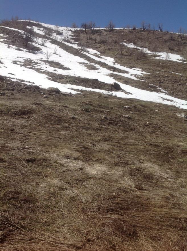
4 Preparing to Monitor Preparing for a field visit Print a copy of the General Orientation Guide: Basics of Wilderness Study Area Monitoring and this site-specific guide from wildsnap.org. Take printed copies of relevant maps. Copies of the Tooele 1:100K surface management maps are available for purchase from local BLM Offices ( Long-term volunteers may qualify for free maps under administrative use and a volunteer agreement; discuss with your BLM liaison. Setting and Terrain North Stansbury Mountains Wilderness Study Area (WSA) is a part of the north-south trending Stansbury mountain range located in Tooele County, Utah approximately 40 miles west of Salt Lake City. The WSA consists of 10,480 acres of public lands administered by the Utah BLM Salt Lake Field Office. The WSA is situated just north of the Deseret Peak Wilderness (managed by the US Forest Service) and south of the Great Salt Lake. The North Stansbury range rises above the desert between two valley floors with elevations varying between 5,200 feet along the northern base of the range and up to 8,800 feet on the southern end. Dimensionally, it is roughly six miles long from north to south and three miles wide from east to west consisting of steep V-shaped canyons that increase in elevation from the north to south. Vegetation consists primarily of juniper-conifer forests with different elevations providing for distinct growth zones. Lower elevations are covered with typical juniper and sagebrush scrublands while higher elevations see wild rose, service berry and mountain mahogany. According to BLM, there are approximately 180 species of wildlife inhabiting the area including cougar, bobcat, deer, grouse, raptors, and cottontails. Both the golden eagle and bald eagle are commonly found in the North Stansbury range as well as Rocky Mountain bighorn sheep which were re-introduced into the area between 2005 and The area is predominately used by hunters during hunting seasons and by hikers and sightseers throughout the year. The North Stansbury Mountains WSA offers an excellent opportunity to escape the crowds while remaining within easy reach of the Salt Lake area. 4


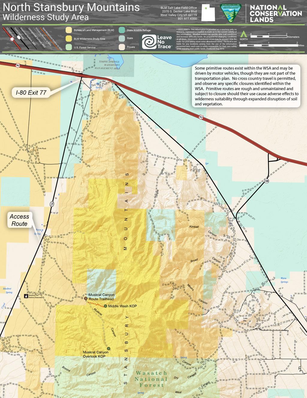
5 Access Routes General access directions are given below; please see the Monitoring Areas and Key Observation Points section starting on page 8 for additional directions. Transportation to and from North Stansbury Mountains WSA is not provided by BLM or ACE. Travel to WSA boundary requires vehicles that have moderate to high clearance. Volunteers should park and walk at any point along the access road if the road appears too rough to safely drive. Avoid attempting to access the area during inclement weather or when the roads are wet and rutting would occur. It is also recommended that all vehicles be equipped with at least one spare tire, tools, and supplies to handle emergencies. Vehicle access to the North Stansbury Mountains is easiest from Interstate 80. Take the Rowley Dugway exit (Exit 77), six miles east of Delle, UT and follow the CR 196/Skull Valley Road approximately five miles south. The WSA access road is located just past mile marker 31 on the east side of the road. (Note: The access route is located north of the Muskrat Fire Station. If you pass the fire station sign, you have traveled too far south). There are two gates between the road and a small BLM kiosk located approximately ¼ mile up the gravel road as well as a small structure. These gates may be closed, but should not be locked. Please leave gates as you find them. About 2.8 miles up the rough and rocky road is a fence delineating the WSA boundary. The BLM requests that volunteers park just before the gate and pull off of the route to avoid obstructing the gate. Access Route (Looking east from CR 196) Parking Location just west of WSA boundary fence 5
.")
6 Trailhead/Parking Location Decimal Degrees Degrees, minutes, seconds Latitude Longitude Latitude Longitude Muskrat Canyon Route TH ' 4.8" N ' 50.5" W Parking at this location will allow volunteers to follow the route up Muskrat Canyon on foot, approximately two miles to the Key Observation Point (KOP). Be sure to close the gate after crossing into the WSA. The route up Muskrat Canyon (in the southwestern section of the property) may legally experience limited OHV use; the route has not been formally closed to OHV travel in a land use plan but is not advertised for motorized use nor recommended for WSA Boundary on Muskrat Canyon travel. Volunteers may encounter lawful use of the Route route by the grazing lessee. However, volunteers should not expect to encounter any other motorized use off of the Muskrat Canyon route within the WSA. Please document any observed OHV use within the WSA within the app. Access directions are included for the desired KOPs. However, the central and southern portions of the Stansbury Mountains are more easily reached from the east side of the range, south and west of Grantsville. Volunteers may travel at their leisure to explore other areas of the WSA. Water Availability No reliable water sources are available in the WSA. Be sure to pack in adequate water (recommended at one gallon/person/day). Services and Facilities There are currently no services or facilities provided in the WSA; however, due to its close proximity to Interstate 80 and Grantsville, access to food, fuel, and emergency services is relatively easy. 6
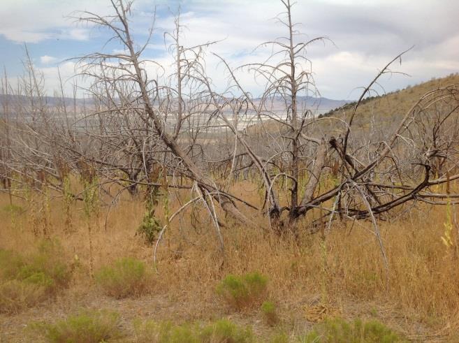
7 Communications Cell phone service is generally available throughout the WSA depending on your provider. Phone access is also available in nearby Grantsville. Monitoring the WSA Signs Portal signs and visitor kiosks have been placed at strategic access points off of main routes along the WSA. Where the WSA boundary occurs at the end of authorized vehicle routes, fiber-glass signs and/or posts have been placed to notify the public that motorized access is not permissible beyond that point. Monitors should report damage of signs to BLM by selecting Disturbances/Impairments/Maintenance then Signs and taking a photo with any necessary notes within the app. Allowable Uses or Exceptions to the Non- Impairment Standard within the North Stansbury Mountains WSA BLM has an active grazing allotment within the Muskrat Canyon Area from June 15 through October 15. Volunteers may encounter cattle and authorized grazing lessees during the summer and early fall grazing season. There are authorized livestock water developments (troughs and water pipeline) located within Muskrat Canyon. Identified Resource Issues The main resource concerns in the WSA are illegal OHV use and BLM sign vandalism and litter. Please pack out litter and trash when possible. The highest visitation occurs during big game hunting seasons and on holiday weekends. Potential or Documented Supplemental Values Supplemental values include ecological, geological, or other features of scientific, educational, scenic, or historical value. Within the North Stansbury Mountains WSA, supplemental values would primarily involve wildlife habitat, especially for Rocky Mountain bighorn sheep, elk, black bear, deer, cougar, or any other large mammals. The cliff faces near the top of Muskrat Canyon or large trees may also provide habitat for native raptor species. The resiliency of wildlife habitat and natural conditions 7
8 within the WSA holds increased importance since most of the area was heavily burned in the summer of Encounters with any significant wildlife should be documented to provide information about how this area has recovered from wildfire. Please document any features of interest, such as occurrence of a threatened or endangered species. Please be advised that the location of cultural and archeological resources is protected and should not be shared with other members of the public. Monitoring Areas and Key Observation Points Volunteers are encouraged to explore the entire North Stansbury Mountains WSA at their discretion. However, BLM has identified two KOPs as areas of high priority for monitoring. Monitoring areas are generally located along routes or areas of potential intensive use within a WSA. Volunteers are asked to prioritize visits to the area listed below. KOPs are exact locations within a WSA where surface disturbance or visitor use may be concentrated or the area has been identified as a point of particular monitoring interest. Muskrat Canyon has been identified as the monitoring area of focus for the North Stansbury Mountains WSA. Within this monitoring area are two KOPs, the coordinates of which are given in Table 1, and identified in the map and location photos. The hike from the parking area to Muskrat Canyon includes approximately 500 feet in elevation gain. Table 1: Monitoring Area Muskrat Canyon Area Key Observation Point (KOP) Name Decimal Degrees Degrees, minutes, seconds Latitude Longitude Latitude Longitude Muskrat Canyon Overlook Middle Wash Overlook N N W W 8


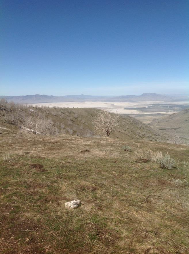
9 Muskrat Canyon Overlook KOP Looking North Muskrat Canyon Overlook KOP Looking East Muskrat Canyon Overlook KOP Looking South Muskrat Canyon Overlook KOP Looking West 9


10 Middle Wash Overlook KOP Looking North Middle Wash Overlook KOP Looking East Middle Wash Overlook KOP Looking South Middle Wash Overlook KOP Looking West 10
The Lake Creek Ranch. Located in the foothills of the Owl Creek Mountains in western Hot Springs County, Wyoming
 The Lake Creek Ranch Located in the foothills of the Owl Creek Mountains in western Hot Springs County, Wyoming Experienced Professional Ranch Brokers Specializing in the sale of ranches, farms, & recreational
Subject to sale, withdrawal, or error.
 We are privileged to have the exclusive listing on a very scenic ranch in the beautiful western foothills of the Jemez Mountains in the northwest central area of New Mexico. This outstanding offering is
LION MOUNTAIN RANCH JEFF DAVIS COUNTY. CHARLES M. DAVIDSON Partner/ Agent REPUBLICRANCHES.
 LION MOUNTAIN RANCH JEFF DAVIS COUNTY CHARLES M. DAVIDSON Partner/ Agent 210-415-5570 cmd@republicranches.com REPUBLICRANCHES.COM LION MOUNTAIN RANCH Lion Mountain Ranch, named for only one of the many
placed on the market.
 With Mimbres River frontage and tremendous grass forage, this jewel in New Mexico s Southern Gila Region is a must have for the discriminating buyer looking to have it all in one easily operated grazing
TWO FORKS RANCH A5 REAL ESTATE. 790 Acres. Smiths Fork - Lincoln County - Wyoming
 TWO FORKS RANCH 790 Acres Smiths Fork - Lincoln County - Wyoming A5 REAL ESTATE WWW.A5REALESTATE.COM QUICK FACTS Located in the upper Smiths Fork drainage of Lincoln County, Wyoming, the Two Forks Ranch
PARADISE CANYON RANCH
 PARADISE CANYON RANCH 4,413 Acres Lost Creek - Morgan County - Utah A5 REAL ESTATE WWW.A5REALESTATE.COM A5 REAL ESTATE 2 Paradise Canyon Ranch QUICK FACTS Located in upper Lost Creek, Morgan County, Utah
Starlite Ranch INTERMOUNTAIN REALTY GROUP S Holladay Blvd., Salt Lake City, Utah,
 Starlite Ranch Millard County, Utah 960 Acres $795,000 INTERMOUNTAIN REALTY GROUP 4571 S Holladay Blvd., Salt Lake City, Utah, 84117 801-277-0800 www.intermountainrealtygroup.com Welcome to Starlite Ranch
La Madre Wilderness Area
 La Madre Wilderness Area Rock Climbing Inventory Statistics: Area: Walls La Madre North 3 24 136 22 Kraft Mt./Gateway Canyon White Rock Springs Willow Springs East The Promised Land 18 4 3 3 12 23 11 24
MCDERMITT, NEVADA OREGON-NEVADA BORDER
 ZIMMERMAN RANCH MCDERMITT, NEVADA OREGON-NEVADA BORDER The Zimmerman Ranch is located approximately 15 air miles directly west of the community of McDermitt, Nevada. The ranch straddles the Nevada Oregon
JC Mesa Ranch. Colorado - San Miguel County - Telluride
 Commanding stunning views of Telluride and surrounding peaks, the 2,379 deeded-acre JC Mesa Ranch is one of the only remaining undeveloped and unencumbered ranches in the Telluride area. Surrounded by
2012 Diamond Complex Assessment BLM administered: Battle Mountain, Ely, Elko districts
 2012 Diamond Complex Assessment BLM administered: Battle Mountain, Ely, Elko districts wild horse removal scheduled January 2013 Horse Canyon, Diamond HMA July 2012 Preliminary Report (Final Version) of
White Horse Canyon Ranch
 White Horse Canyon Ranch Modoc County, California Proudly Offered By 707 Merchant Street, Suite 100, Vacaville, Ca 95688 (707) 455-4444 Office (707) 455-0455 Fax info@caoutdoorproperties.com Introduction
Wildlife Introduction
 Wildlife Introduction The wildlife section of this chapter is divided into sections for various habitats and groups of species. Old growth, snags and downed wood, and riparian areas are unique habitats
March 18, 2010 (801) Shed Antler Gatherers and Deer on the Henrys
 Shed Antler Gatherers and Deer on the Henrys") Utah Wildlife News Mark Hadley, Editor March 18, 2010 (801) 538-4737 In this issue: Deep snow and shed antlers See sage-grouse at three events Bears are doing well Shed Antler Gatherers and Deer on the
Utah Wildlife News Mark Hadley, Editor March 18, 2010 (801) 538-4737 In this issue: Deep snow and shed antlers See sage-grouse at three events Bears are doing well Shed Antler Gatherers and Deer on the
Youth Cow Elk and Doe Deer Hunts at Burns Hole -Ranching for Wildlife-
 Youth Cow Elk and Doe Deer Hunts at Burns Hole -Ranching for Wildlife- Bull Basin Outfitters in conjunction with the Burns Hole Ranching for Wildlife Program is proud to offer the Northern Colorado Chapter
HOLT MOUNTAIN RANCH GLENWOOD, NEW MEXICO 74.4 (15.7 IRRIGATED) DEEDED ACRES 15,722 USFS ACRES
 DEEDED ACRES 15,722 USFS ACRES") HOLT MOUNTAIN RANCH GLENWOOD, NEW MEXICO 74.4 (15.7 IRRIGATED) DEEDED ACRES 15,722 USFS ACRES Offered Exclusively By Chas S. Middleton and Son, LLC www.chassmiddleton.com 1507 13th Street Lubbock, Texas
HOLT MOUNTAIN RANCH GLENWOOD, NEW MEXICO 74.4 (15.7 IRRIGATED) DEEDED ACRES 15,722 USFS ACRES Offered Exclusively By Chas S. Middleton and Son, LLC www.chassmiddleton.com 1507 13th Street Lubbock, Texas
Confederated Tribes of the Umatilla Indian Reservation -- Cayuse, Umatilla, and Walla Walla Tribes
 2018-2019 Treaty Hunting Seasons and Regulations Confederated Tribes of the Umatilla Indian Reservation -- Cayuse, Umatilla, and Walla Walla Tribes CTUIR Tribal Hunting Rights Reserved in 1855 Treaty a
Description of Road Management Objectives, Existing Use, and Proposed Use:
 Engineering Report White River National Forest Eagle-Holy Cross Ranger District Analysis of Road # 700 Red Sandstone Road for Motorized Mixed Use Designation Page 1 of 12 Forest: White River District:
Subject to sale, withdrawal, or error.
 We are proud to offer for sale this long-term family ownership ranch located in northwestern Cottle County. The property is located northwest of Paducah in the central Rolling Plains and adjoins the 28,000
1. What is the National Wildlife Refuge System? 2. Who started the National Wildlife Refuge System? When?
 Honors Biology ANWR Scored Discussion Prep Handout 1 Source: US Fish and Wildlife Service / ANWR Name: Purpose: The purpose of this handout is to help you research some of the basic facts regarding the
ROAN CREEK RANCH De Beque, Colorado - Garfield County
 ROAN CREEK RANCH De Beque, Colorado - Garfield County This 120-acre ranch located in a private valley northeast of Grand Junction, Colorado, features gorgeous views, lush irrigated meadows, good water
Description of Road Management Objectives, Existing Use, and Proposed Use:
 Engineering Report White River National Forest Eagle-Holy Cross Ranger District Analysis of Road # 600 Coffee Pot Road for Motorized Mixed Use Designation Page 1 of 12 Forest: White River District: Eagle-Holy
The Greater Sage-Grouse:
 The Greater Sage-Grouse: Hunter opinions regarding potential conservation strategies in eleven western states For: National Wildlife Federation October 30, 2014 PO Box 6435 Fernandina Beach, FL 32035 Tel
MOUNTAIN LION MANAGEMENT GUIDELINES FOR LION DAU-L17
 MOUNTAIN LION MANAGEMENT GUIDELINES FOR LION DAU-L17 GAME MANAGEMENT UNITS 123, 124, 125, 126, 127, 128, 129, 130, 132, 133, 134, 135, 136, 137, 138, 139, 141, 142, 143, 144, 145, 146, & 147 Prepared for:
RULES AND REGULATIONS
 RULES AND REGULATIONS All rules apply to the sections of the Backcountry Wilderness Area of Highlands Ranch which are owned by the Highlands Ranch Community Association (HRCA) and have access provided
Crook Ranch. Tehama County, California. Proudly Offered By
 Crook Ranch Tehama County, California Proudly Offered By 707 Merchant Street, Suite 100, Vacaville, Ca 95688 (707) 455-4444 Office (707) 455-0455 Fax info@caoutdoorproperties.com www.californiaoutdoorproperties.com
Confederated Tribes of the Colville Reservation. Aboriginal Territories in Washington
 Confederated Tribes of the Colville Reservation Aboriginal Territories in Washington Tribal Trust Lands and Allotments Outside of the Colville Reservation and North Half 2016 Traditional Hunting Season
Visitor Guidelines for WPC-owned Properties. Last revised 5/20/2010
 WESTERN PENNSYLVANIA CONSERVANCY Visitor Guidelines for WPC-owned properties 800 Waterfront Dr., Pittsburgh, PA 15222 412-288-2777, www.waterlandlife.org Visitor Guidelines for WPC-owned Properties Last
MOUNTAIN LION MANAGEMENT GUIDELINES FOR LION DAU L-1
 MOUNTAIN LION MANAGEMENT GUIDELINES FOR LION DAU L-1 Game Management Units 1, 2, 201 Prepared for: Colorado Division of Wildlife Northwest Region By: Darby Finley Terrestrial Wildlife Biologist Meeker,
Camelot at Strawberry Pinnacles
 Camelot at Strawberry Pinnacles Your Well-Earned Slice of Paradise Duchesne County, Utah 7.53 Acres $749,000 3616 Elmwood Street, Salt Lake City, UT 84106 801-870-1801 info@landrancher.com Welcome to Camelot
Marcella Creek. Elk & Deer Hunting Property With Springs and Creek in the Garnet Mountain Range. 160 acres for $195,000
 Granite County Elk & Deer Hunting Property With Springs and Creek in the Garnet Mountain Range 160 acres for $195,000 Bordering State Land and Nature Conservancy lands, this property is prime for elk and
The Heber-Reno Domestic Sheep Driveway and Management of Bighorn Sheep in Arizona.
 The Heber-Reno Domestic Sheep Driveway and Management of Bighorn Sheep in Arizona. The driveway occurs on 60 miles of the Apache Sitgreaves National Forest and 80 miles of the Tonto National Forest. The
FEATURED NEWS. Greater Sage Grouse Habitat. View Web Version Like Tweet Forward
 View Web Version Like Tweet Forward FEATURED NEWS Greater Sage Grouse Habitat By: Terry Fieseler, Broker Traveling through the Rocky Mountain West, the untrained eye might gaze across the seemingly endless
ACCESS & HABITAT PROGRAM Regional Advisory Council Project Proposal Review
 ACCESS & HABITAT PROGRAM Regional Advisory Council Project Proposal Review ODFW Region / A&H Regional Council: East Region / Malheur Council Project Proposal Title: Mackenzie Access Project Applicants(s):
CONNECTING COMMUNITIES THROUGH TRAILS
 CONNECTING COMMUNITIES THROUGH TRAILS CONNECTING COMMUNITIES THROUGH TRAILS Create a master trails plan Connect communities to each other Connect communities to Deseret Peak Complex Access to a maintained
Ely, Nevada Highway Commercial Office/Warehouse/Industrial Property
 Ely, Nevada Highway Commercial Office/Warehouse/Industrial Property 6,000 + SF Office/Warehouse has 2 half baths, office, and roll up doors on the east and west walls 5.81 acre parcel fronts Highway 93
O Bar O Ranch Graham County, Arizona
 O Bar O Ranch Graham County, Arizona Offered for sale exclusively by: Walter Lane Headquarters West, Ltd. 4582 N 1 st Avenue Tucson, AZ 85718 Telephone (520) 792-2652; Fax (520) 792-2629 www.headquarterswest.com
ROCK CLIMBING STRATEGY
 Stawamus Chief, Shannon Falls & Murrin Provincial Parks ROCK CLIMBING STRATEGY Prepared by: Ministry of Environment, Lands and Parks BC Parks, Garibaldi/Sunshine Coast District Brackendale, BC and Volunteer
Management History of the Edwards Plateau
 Management History of the Edwards Plateau Eco regions of Texas Edwards Plateau 24,000,000 acres About 15,000 years ago, the Edwards Plateau was much cooler and was more forested than today. Pollen counts
Job Title: Game Management, Subsection B Game Management Mountain Lion. SPECIES: Mountain Lion
 SPECIES: Goal: Manage the mountain lion population, its numbers and distribution, as an important part of Arizona s fauna and to provide mountain lion hunting recreation opportunity while maintaining existing
THE MESA CHIVATO RANCH
 Wild West Properties, LLC 7020 Santa Marisa, NE Albuquerque, NM 87113 505-836-4558 http://www.wildwestproperties.com/ Randy J. Wood Qualifying Broker Cell: 505-980-8019 E-mail: rjwood5@comcast.net THE
B A G G S, W Y O M I N G - C R A I G, C O L O R A D O
 B A G G S, W Y O M I N G - C R A I G, C O L O R A D O Rockin J Ranch The Rockin J Cattle Ranch is located on the Little Snake River just west of Baggs, Wyoming, with land straddling either side of the
Broken Bar W Ranch TETON VALLEY, IDAHO. Hunting Ranching Fly Fishing Conservation
 Broken Bar W Ranch TETON VALLEY, IDAHO Hunting Ranching Fly Fishing Conservation Broken Bar W Ranch TETON VALLEY, IDAHO Introduction: The Broken Bar W Ranch is located in Driggs, Idaho, the county seat
Widow Valley Ranch. Modoc County, California. Proudly Offered By.
 Widow Valley Ranch Modoc County, California Proudly Offered By www.californiaoutdoorproperties.com 707 Merchant Street, Suite 100, Vacaville, Ca 95688 (707) 455-4444 Office (707) 455-0455 Fax info@caoutdoorproperties.com
BRENT N. LONNER, Montana Fish, Wildlife & Parks, Fish & Wildlife Division, PO Box 488, Fairfield, MT 59436, USA
 History of Bighorn Sheep in the Sun River Area, Montana BRENT N. LONNER, Montana Fish, Wildlife & Parks, Fish & Wildlife Division, PO Box 488, Fairfield, MT 59436, USA Abstract: The Sun River bighorn sheep
Saint John's Abbey Arboretum Controlled Deer Hunt 2013
 Saint John's Abbey Arboretum Controlled Deer Hunt 2013 Welcome to Saint John s for the 12th controlled deer hunt since 1933. 17 July 2013 The following rules apply to all hunters allowed on Saint John
Albany County, Wyoming
 Albany County, Wyoming Western Land Sales 123 South 12th Street Thermopolis, WY 82443 www.westernland.net Roy Ready 307-234-2211 J.R. Kvenild 307-259-5000 China Wall Ranch Albany County, WY LOCATION &
COUNTY ADVISORY BOARD TO MANAGE WILDLIFE 2019 BIG GAME SEASONS RECOMMENDATIONS
 COUNTY ADVISORY BOARD TO MANAGE WILDLIFE 2019 BIG GAME SEASONS RECOMMENDATIONS Please check the appropriate blanks and list any exceptions below each hunt. 1. Resident and Nonresident Black Bear Either
Mule Deer. Dennis D. Austin. Published by Utah State University Press. For additional information about this book
 Mule Deer Dennis D. Austin Published by Utah State University Press Austin, D.. Mule Deer: A Handbook for Utah Hunters and Landowners. Logan: Utah State University Press, 2010. Project MUSE., https://muse.jhu.edu/.
Teton County Related Hunting and Fishing Spending, For the Wyoming Wildlife Federation. David T. Taylor & Thomas Foulke
 Teton County Related Hunting and Fishing Spending, 2015 For the Wyoming Wildlife Federation University of Wyoming, Department of Agricultural & Applied Economics David T. Taylor & Thomas Foulke 1 February
MOUNTAIN LION DATA ANALYSIS UNIT L-6 MANAGEMENT PLAN
 MOUNTAIN LION DATA ANALYSIS UNIT L-6 MANAGEMENT PLAN GAME MANAGEMENT UNITS 15, 25, 26, 34, 35, 36, 43,44,45,47,444,471 NORTHWEST REGION Prepared for: Colorado Division of Wildlife By: John Broderick Wildlife
2017 LATE WINTER CLASSIFICATION OF NORTHERN YELLOWSTONE ELK
 2017 LATE WINTER CLASSIFICATION OF NORTHERN YELLOWSTONE ELK A collaborative survey by the Northern Yellowstone Cooperative Wildlife Working Group Report Prepared by: Karen Loveless, Montana Fish Wildlife
Glenn Bunch, Chairman, Members: Billie Williams Jr., Johnny Peterson, Wayne Larson, Darren Hamrey Marlene Bunch, Recording Secretary
 Minutes of the Mineral County Advisory Board to Manage Wildlife Meeting Date & Time: Monday, January 22, 2019 at 6:00 PM Location : MEETING ROOM, HAWTHORNE LIBRARY Present: Glenn Bunch, Chairman, Members:
Rocky Water Ranch 1375+/- Acres Hamilton County, Texas $4,812,500 ($3,500/acre)
") 1375+/- Acres Hamilton County, Texas $4,812,500 ($3,500/acre)! Bret Polk Mobile: (254) 965-0349 Office: (214) 361-9191 LOCATION: The Rocky Water Ranch is located approximately 4 miles South of Hico, Texas,
1375+/- Acres Hamilton County, Texas $4,812,500 ($3,500/acre)! Bret Polk Mobile: (254) 965-0349 Office: (214) 361-9191 LOCATION: The Rocky Water Ranch is located approximately 4 miles South of Hico, Texas,
Carpenter Real Estate Presents:
 Carpenter Real Estate Presents: The El Paseo de San Antonio Ranch is your opportunity to own one of the finest and most renowned cattle ranches in the Highlands and Davis Mountains of Texas. The ranch

PROTECTING SAGE GROUSE AND THEIR HABITAT IN THE WEST. John Harja Senior Counsel on Detail to the Public Lands Office
 PROTECTING SAGE GROUSE AND THEIR HABITAT IN THE WEST John Harja Senior Counsel on Detail to the Public Lands Office Chick Female (Hen) Male (Cock) Nest w eggs Lek Sage-grouse need sagebrush. Landscape-scale
Wildlife Issues With Oil and Gas Exploration. Peter D. McKone, CWB Senior Project Director
 Wildlife Issues With Oil and Gas Exploration Peter D. McKone, CWB Senior Project Director pmckone@wcgrp.com 817-946-7379 Outline Nationwide Issues Regional Issues Industry Examples General Wildlife Impacts
Subject to sale, withdrawal, or error.
 The 2400 Ranch is located on both sides of Highway 2400 in western Terrell County, Texas. The property is approximately 15 air miles north of Sanderson. This Trans-Pecos region of Texas is widely recognized
The Cerf Pasture is located about 30 miles southeast of Fort Stockton, Texas on the east side of US Highway 285.
 We are proud to offer for sale the Cerf Pasture, which is the eastern portion of the massive Longfellow Ranch. The Longfellow Ranch is a very well known and widely recognized West Texas Ranch comprising
HEADQUARTERS WEST, LTD.
 Chambers Ranch Coconino County, Arizona Offered for Sale Exclusively by: Andy Groseta Headquarters West, Ltd. P.O. Box 1840 Cottonwood, Arizona 86326 Office (928) 634-8110 Cell (928) 300-6621 Email wdartranch@qwestoffice.net
Twin Canyons Ranch 3,019+/- Acres Throckmorton County, Texas $4,211,505 ($1,395/acre)
") Office: (214) 361-9191 Twin Canyons Ranch 3,019+/- Acres Throckmorton County, Texas $4,211,505 ($1,395/acre) GENERAL DESCRIPTION: The 3019+/- acre Twin Canyons Ranch is one of the most scenic and majestic
Office: (214) 361-9191 Twin Canyons Ranch 3,019+/- Acres Throckmorton County, Texas $4,211,505 ($1,395/acre) GENERAL DESCRIPTION: The 3019+/- acre Twin Canyons Ranch is one of the most scenic and majestic
ADOPTED REGULATION OF THE BOARD OF WILDLIFE COMMISSIONERS. LCB File No. R Effective September 9, 2016
 ADOPTED REGULATION OF THE BOARD OF WILDLIFE COMMISSIONERS LCB File No. R145-15 Effective September 9, 2016 EXPLANATION Matter in italics is new; matter in brackets [omitted material] is material to be
UTAH ACTION PLAN. For
 UTAH ACTION PLAN For Implementation of Department of the Interior Secretarial Order 3362: Improving Habitat Quality in Western Big-Game Winter Range and Migration Corridors Introduction - There was a great
Mining & Petroleum Focus Group Southern Rocky Mountain Management Plan. Synopsis of Focus Group Key Issues
 Southern Rocky Mountain Management Plan Page 1 of 6 Synopsis of Focus Group Key Issues Sectors who brought forth issues are listed after the issue in brackets. I. Timeline Completing the plan by June,
Petty Ranch 1,660+/- Acres Shackelford & Haskell County, Texas $2,647,700 ($1,595/acre)
") Blake Hortenstine Mobile: (214) 616-1305 Office: (214) 361-9191 Petty Ranch 1,660+/- Acres Shackelford & Haskell County, Texas $2,647,700 ($1,595/acre) Shackelford & Haskell County, Texas 1,660 +/- Acres
Blake Hortenstine Mobile: (214) 616-1305 Office: (214) 361-9191 Petty Ranch 1,660+/- Acres Shackelford & Haskell County, Texas $2,647,700 ($1,595/acre) Shackelford & Haskell County, Texas 1,660 +/- Acres
Borders BLM Lands Near The Dearborn and Missouri Rivers acres for $54,750
 Cascade/Wolf Creek, Montana Cascade County Borders BLM Lands Near The Dearborn and Missouri Rivers 47.98 acres for $54,750 Montana property bordering BLM land with amazing views from an incredible cabin
3B Ranch 1495+/- Acres Bosque & Erath County, Texas $4,111,250 ($2,750/acre) Bret Polk Mobile: (254) Office: (214)
 Bret Polk Mobile: (254) Office: (214)") 1495+/- Acres Bosque & Erath County, Texas $4,111,250 ($2,750/acre)! Bret Polk Mobile: (254) 965-0349 Office: (214) 361-9191 Bosque & Erath County, Texas 1495 +/- Acres LOCATION: Located 7.5 miles Northeast
1495+/- Acres Bosque & Erath County, Texas $4,111,250 ($2,750/acre)! Bret Polk Mobile: (254) 965-0349 Office: (214) 361-9191 Bosque & Erath County, Texas 1495 +/- Acres LOCATION: Located 7.5 miles Northeast
Wyoming Public Lands Initiative (WPLI) Fortification Creek Advisory Committee Meeting March 13, 2017
 Fortification Creek Advisory Committee Meeting March 13, 2017") Wyoming Public Lands Initiative (WPLI) Fortification Creek Advisory Committee Meeting March 13, 2017 Present: Commissioner Rusty Bell, Campbell County; Commissioner Bill Novotny, Johnson County; Commissioner
Wyoming Public Lands Initiative (WPLI) Fortification Creek Advisory Committee Meeting March 13, 2017 Present: Commissioner Rusty Bell, Campbell County; Commissioner Bill Novotny, Johnson County; Commissioner
MOUNTAIN LION MANAGEMENT GUIDELINES FOR Lion DAU L-16
 MOUNTAIN LION MANAGEMENT GUIDELINES FOR Lion DAU L-16 Game Management Units 69, 82, 84, 86, 691 and 861 Prepared for: Colorado Division of Wildlife Southeast Region By: Allen Vitt Terrestrial Biologist,
EXECUTIVE SUMMARY Feasibility Study on the Reintroduction of Gray Wolves to the Olympic Peninsula
 EXECUTIVE SUMMARY Feasibility Study on the Reintroduction of Gray Wolves to the Olympic Peninsula Prepared by U.S. Fish and Wildlife Service Western Washington Office Introduction Historical records indicate
Identifying Mule Deer Migration Routes Along the Pinedale Front
 Identifying Mule Deer Migration Routes Along the Pinedale Front Prepared for: The Wyoming Wildlife and Natural Resource Trust 500 East Fremont Riverton, Wyoming 82501 Prepared by: Hall Sawyer and Matthew
NEVADA ACTION PLAN. For
 NEVADA ACTION PLAN For Implementation of Department of the Interior Secretarial Order 3362: Improving Habitat Quality in Western Big-Game Winter Range and Migration Corridors Introduction - Secretarial
BULL ELK HUNTING AT DESERET LAND AND LIVESTOCK Read the following carefully and thoroughly
 BULL ELK HUNTING AT DESERET LAND AND LIVESTOCK Read the following carefully and thoroughly Congratulations on drawing a bull elk permit for the Deseret Land and Livestock Cooperative Wildlife Management
NEVADA DEPARTMENT OF WILDLIFE HARVEST MANAGEMENT GUIDELINES FOR HUNTING SEASONS
 NEVADA DEPARTMENT OF WILDLIFE HARVEST MANAGEMENT GUIDELINES FOR HUNTING SEASONS Draft Page 2 of 15 TABLE OF CONTENTS Schedule for formulating harvest management guidelines..............................................
BIOLOGICAL SURVEY OF PROPOSED PROJECTS AT SKI APACHE LINCOLN NATIONAL FOREST SMOKEY BEAR RANGER DISTRICT
 BIOLOGICAL SURVEY OF PROPOSED PROJECTS AT SKI APACHE LINCOLN NATIONAL FOREST SMOKEY BEAR RANGER DISTRICT Abstract On September 10, 2015, Thora Padilla, Director for the Mescalero Apache Tribe, Division
Transition: Wild Horse & Burro Management
 Horses and Burros (Thousands) NATIONAL HORSE & BURRO RANGELAND MANAGEMENT COALITION Advocating for commonsense, ecologically-sound approaches to managing horses and burros to promote healthy wildlife and
ATV/ARGO Trails for Red Indian Lake Outfitting
 ATV/ARGO Trails for Red Indian Lake Outfitting Proponent: Name: Red Indian Lake Outfitting Contact: Fred or Shirley Thorne Address: P.O. Box 5 Buchans, NL A0H 1G0 Telephone: (c) 709.672.7026/7120 info@redindianlake.com
Black Bear Quota Recommendations CR 17-13
 Black Bear Quota Recommendations CR 17-13 Recommendations 41 resident tags 4 nonresident tags Harvest limit of 20 2017 Black Bear Seasons Changes Historically entire area was open 57 out of 82 bears historically
Schoolhouse Spring Ranch in Steptoe Valley North of Ely, NV
 Schoolhouse Spring Ranch in Steptoe Valley North of Ely, NV Steptoe Valley Steptoe Valley is a long valley located in White Pine County, in northeastern Nevada. From the historic community of Currie, the
JULY 2017 SUMMARY BULLETS
 FY 2017 Predator Report Appendix Project 21-02 Comments To: From: NV Department of Wildlife, Bureau of Land Management U.S. Geological Survey, WERC Research Team Subject: March July 2017 Progress Update
Circle W Ranch SPRAY, OREGON. Hunting Ranching Fly Fishing Conservation
 Circle W Ranch SPRAY, OREGON Hunting Ranching Fly Fishing Conservation Circle W Ranch SPRAY, OREGON CIntroduction The Circle W Ranch is located in North Central Oregon. The North border of the ranch runs
2012 Wildlife Studies
 2012 Wildlife Studies Prepared by Cardno ENTRIX Agency Meeting on Draft 2012 Study Descriptions December 8, 2011 1 Project Components 2 Project Region ADF&G GMUs 3 Wildlife Studies for 2012 W-S1: Wildlife
Rock Creek Outfitters
 Rock Creek Outfitters A rare opportunity to buy a complete and successful turn-key outfi tting business in one of the best deer hunting areas of the state. Eastern Montana has a variety of terrain from
Fremont County Related Hunting and Fishing Spending, 2015
 Fremont County Related Hunting and Fishing Spending, 2015 For the Wyoming Wildlife Federation University of Wyoming, Department of Agricultural & Applied Economics David T. Taylor & Thomas Foulke September,
WHITEFISH & ROCK CREEK RANCH
 WHITEFISH & ROCK CREEK RANCH DONLEY COUNTY, TEXAS 3,553.59 ± ACRES Texas Panhandle Live-Water Cattle & Recreational Ranch WHITEFISH & ROCK CREEK RANCH DONLEY COUNTY, TEXAS 3,553.59 ± ACRES We are pleased
Frequently Asked Questions and Answers Regarding the Draft Northern Continental Divide Ecosystem (NCDE) Conservation Strategy
 Conservation Strategy") Frequently Asked Questions and Answers Regarding the Draft Northern Continental Divide Ecosystem (NCDE) Conservation Chris Servheen, USFWS, chris_servheen@fws.gov 5/1/13 Q1. What is the NCDE Conservation?
Frequently Asked Questions and Answers Regarding the Draft Northern Continental Divide Ecosystem (NCDE) Conservation Chris Servheen, USFWS, chris_servheen@fws.gov 5/1/13 Q1. What is the NCDE Conservation?
H. R. To provide for the protection of the last remaining herd of wild and genetically pure American Buffalo. IN THE HOUSE OF REPRESENTATIVES A BILL
 F:\M\HINCHE\HINCHE_0.XML... (Original Signature of Member) TH CONGRESS ST SESSION H. R. To provide for the protection of the last remaining herd of wild and genetically pure American Buffalo. IN THE HOUSE
PRISTINE. PRIVATE. PERFECT.
 PRISTINE. PRIVATE. PERFECT. A sublime parcel of the American West, Inyanga Ranch consists of over 530 acres of beautiful river frontage, ponds, meadows and historic cabins at the end of a box canyon, protected
EMERY GAP RANCH UNION COUNTY, NEW MEXICO LAS ANIMAS COUNTY, COLORADO 8,342 ± DEEDED ACRES 3,302 ± NM STATE LEASE ACRES
 EMERY GAP RANCH UNION COUNTY, NEW MEXICO LAS ANIMAS COUNTY, COLORADO 8,342 ± DEEDED ACRES 3,302 ± NM STATE LEASE ACRES 11,644 ± TOTAL ACRES OFFERED EXCLUSIVELY BY Chas. S. Middleton and Son 806.763.5331
Rules, Regulations, Provisions, and Directives
 Rules, Regulations, Provisions, and Directives District hunting and parking permits: All participants and their helpers must clearly display a District-issued parking permit on the dashboard or rearview
ACCESS & HABITAT PROGRAM Regional Advisory Council Project Proposal Review
 ACCESS & HABITAT PROGRAM Regional Advisory Council Project Proposal Review ODFW Region / A&H Regional Council: East Region / Malheur Council Project Proposal Title: Brown Access Project Applicants(s):
Carbon County Related Hunting and Fishing Spending, 2015
 Carbon County Related Hunting and Fishing Spending, 2015 1 For the Wyoming Wildlife Federation University of Wyoming, Department of Agricultural & Applied Economics AAAAddd David T. Taylor & Thomas Foulke
TRCP National Sportsmen s Survey Online/phone survey of 1,000 hunters and anglers throughout the United States
 #17144 TRCP National Sportsmen s Survey Online/phone survey of 1,000 hunters and anglers throughout the United States Methodology Public Opinion Strategies conducted a national survey of N =1,000 voters
Population Ecology Yellowstone Elk by C. John Graves
 Population Ecology Yellowstone Elk by C. John Graves Group Names: Hour Date: Date Assignment is due: end of class Score: + - Day of Week Date Rocky Mountain elk (Cervus elaphus) living in Yellowstone National
Shimmerhorn Ranch. Buford, Wyoming // Albany County
 Shimmerhorn Ranch Buford, Wyoming // Albany County The Shimmerhorn Ranch is located just off Interstate 80; it lies 20 miles east of Laramie, the home of the University of Wyoming, and 30 miles west of
ARLIS TE.. 25.C66 W ALIS(A RESOURCES Ut1HAH'«Bureau of Land Manaaement. Anchorage WILDLIFE REPORT FOR COPPER RIVER HIGHWAYS ROUTE PREPARED
 WILDLIFE REPORT ALIS(A RESOURCES Ut1HAH'«Bureau of Land Manaaement FOR COPPER RIVER HIGHWAYS ROUTE PREPARED BY ARLIS DIVISION OF WILDLIFE CONSERVATION Anchorage January 1993 TE.. 25.C66 W54 1993 WILDLIFE
Oregon Mule Deer Initiative. 5 Year Summary
 Oregon Mule Deer Initiative 5 Year Summary 2010-2014 EXECUTIVE SUMMARY Mule deer are one of the premier big game species in Oregon and provide significant recreation for both consumptive and non-consumptive
Job Title: Game Management, Subsection B Game Management Mountain Lion. SPECIES: Mountain Lion
 SPECIES: Goal: Manage the mountain lion population, its numbers and distribution, as an important part of Arizona s fauna and to provide mountain lion hunting recreation opportunity while maintaining existing
Job Title: Game Management, Subsection B Game Management Mountain Lion
 Job Title:, Subsection B Goal: Manage the mountain lion population, its numbers and distribution, as an important part of Arizona s fauna and to provide mountain lion hunting recreation opportunity while