Explore the outdoors in Shelby County
|
|
|
- Frederick Black
- 5 years ago
- Views:
Transcription


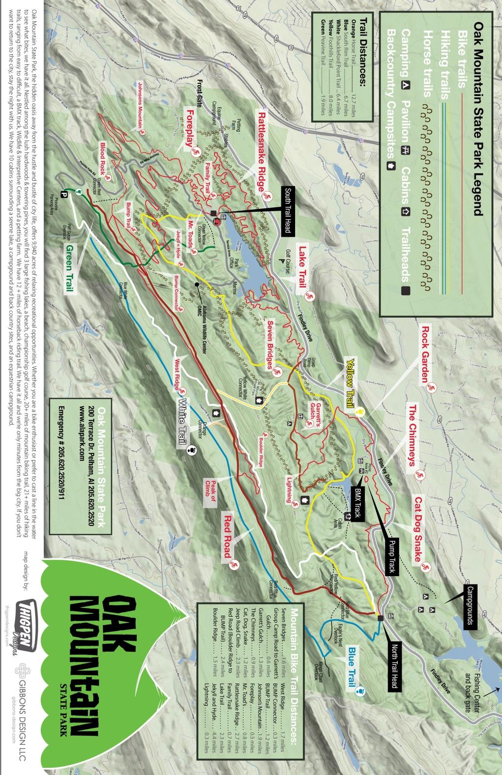
1 Explore the outdoors in Shelby County Oak Mountain Trail GPS: Trail Location: Address: Oak Mountain State Park Trail 200 Terrace Drive Pelham, AL Type of Trail: Walking, Mountain Biking, Horseback Riding Biking Trails 26 Miles About 26 miles, the trail (red blazes) is several loops made up of mostly single track but some fire/forest/paved roads. Ride either direction. The trails are varied and heavily ridden, and expect to see riders of all ages and abilities, as well as hikers, back-packers, kids, dogs, anywhere on the trail. Please note that bikes are only permitted off road on the red trail. Fines are available from any park ranger for being caught on any other trail with a bike (whether you are riding or not). The trail is loosely made up of the following continuously connected sections (traveling counter-clockwise from the South Trailhead): Other Information: The Double Oak Trail at Oak Mountain State Park was recently added to the IMBA (International Mountain Bike Association) list of only 52 must ride trails in the WORLD. The approximately 26 mile length, and growing, trail is
2 mostly tight single track, with about five miles of the "loop" double track, and about 1900 feet of climbing. Lake Trail: Rattlesnake Ridge: Family Trail: 2.3 Miles This is a 4-5 foot wide level trail suitable for all ages and abilities. It offers some of the best views of the lake and the park itself. Please be cautious of horse traffic at trail intersections. 2.7 Miles Narrow in places and twisty throughout, this leg churner is sure to keep you on your toes. Rocks for texture, obstacles for fun and some short fast downhill in this 2.7 mile thrill ride through the dense pine forest of the park. 0.7 Miles This.7 mile serene glide through the oaks is a great way to enjoy some single track without having to concentrate too much on the trail itself. There are some obstacles but nothing anyone can't handle.
3 Mr. Toad's Wild Ride: Foreplay: Johnson's Mountain: 0.8 Miles All singletrack running counterclockwise along the loop from the South Trailhead approximately.8 miles. Ends at the junction of the bike trail and the horse trail next to Peavine Road. hills but some tight turns and a few narrow spots between trees. Very smooth and flowing. 0.5 Miles Continuing counterclockwise along the loop from the horse trail to the bottom of Johnson's Mountain, Foreplay is also all singletrack. Only 1/2 mile long, very smooth and flowing, and contains one sharp S-turn followed by a short bumpy downhill to the bottom of Johnson's Mountain. Go straight across the gravel lot at the bottom to get to Johnson's Mountain. 1.9 Miles ~1.9 miles of hilly woody singletrack. The first section crosses a creek on a bridge then follows the creek, then
4 climbs to the spine of Johnson's first ridge. Hundreds of man hours of trail work in 1997 by BUMP created a steady climb and quick descent along Johnson's other two ridges. The trail continues downhill through a banked turn and crosses a bridge before crossing Peavine Road. BUMP Trail: 1.2 Miles This is singletrack that climbs about 1.2 miles to the Red Road at the top of the ridge. Hilly but smooth at the bottom, and rocky, technical and steep at the top. A purpose-built log crossing, Blood Rock, and a set of tight, rocky switchbacks mark the upper part of the trail. Blood Rock is named after a red trail blaze painted onto a sharp rock next to the trail. Riding down is challenging but easy to master. Riding up is possible by only a few people - beware of the wet slippery rocks. Turn left onto the Red Road at the top of the BUMP trail. Jekyll & Hyde: 4.5 Miles Get ready for some tight spots, big rocks, twisting berms and speed to boot. This 4.5 mile roller coaster down Double Oak Mountain has it all. Built in the fall of 2011, it starts out with tight rolling singletrack along the cliffs of the old CCC Quarry and transitions into a half mile descent down a trail littered with rocks and features a three foot
5 rolling drop. More rocks and obstacles await you before you whip around the Big Rock into some of the fastest singletrack in park. The last 3 miles are a series of white knuckling berms, dips and banked turns mixed in with some short climbs zipping you through some beautiful pine and hardwood groves. Please be aware of blind turns and use caution accordingly. The trail ends back at the road across from Mr. Toad's Wild Ride. Go back to the trailhead or head back up the mountain. BUMP Connector: 0.3 Miles The West Ridge: Boulder Ridge: 1.7 Miles Opened in vember of 2010, this beautiful 1.7 mile ride along the ridge of Double Oak Mountain is sure to be fun and challenging. Very different from other areas of the park where you will see tight singletrack mixed in with plenty of rocks, great views and tree canopies. There are optional features on the side for those inclined for some rockhopping or riding off a 6 foot tall boulder.
6 Red Road: Cat Dog Snake: 1.5 Miles Expert riders ONLY! Really test your riding skills like no other place in the Birmingham area. Bring your big boy/girl pants as this 1.5 miles of big rocks, tight chokes, obstacles and drops of up to 6 feet will put your bike handling skills through the toughest of challenges. Please use your best judgement when riding here. It is a completely optional route but one well worth exploring. Look for the split rail fencing at each end. 4.7 Miles This is a fire road leading 4.7 miles counterclockwise from the top of B.U.M.P. to the rth Trailhead parking area. The last 2.5 miles are a heart pounding downhill, with 8 creek crossings made smooth by mortared flagstones placed by the Civilian Conservation Corps. Great for catching big-air, but watch out for the rocky landings. Keep control of your bike, as the Red Road is also used by hikers and bikers riding up-hill. The Red Road ends at the rth Trailhead parking lot on the main park road. To continue on the bike trail, turn left ~100 yards before the gate at the end of the Red Road and follow the red trail markers across the bridge. **Do not turn left too early - this will take you down the yellow trail to Maggie's Glen: an area off-limits for bikes.
7 The Chimneys: Garrett's Gulch: 1.2 Miles Woody, smooth singletrack running roughly parallel to the main park road. One moderate climb at the end places you at the park road leading to the cabins. Cross the cabin road (paved) to continue on the bike trail. 0.9 Miles After climbing to the top of the ridge from the cabin road and descending to the foot of the hill, look for the remnants of a cabin (especially the brick chimney) on your right. This singletrack trail takes you through tight turns where roots grab your wheel and trees grab your handlebars. After crossing a wooden bridge, look for the BMX track on your left. About 100 yards later the trail crosses Tranquility Rd. Water is available at the BMX area from a spigot at the end of the pavement by the big field. Cross the road and continue on the trail. 1.3 Miles A technical rider's playground. Lots of white-tailed deer sightings in this area, especially in the early mornings.
8 There is a 12 foot long, 16 inch wide bridge over a 4 foot creek deep creek here to test your nerves and some other obstacles. Further up is a small rock garden and ends with a short climb and then a descent to the Group Primitive Camping Road, with a large fallen tree crossing at the bottom. Test your riding skills on the 40 foot long fallen oak or ride around it. Lightning: 0.8 Miles Introduces gravity oriented riding to the red trail experience. Built in winter 2012 by Progressive Trail Designs in collaboration with BUMP volunteers, it offers ~4500' of unique and challenging features. This trail is not a cross country trail, but it is an optional, purpose built, one-way "downhill flow trail"; however, there are sections that still require pedaling. Access the lightning trailhead after climbing the group camp road ~0.8 miles above the Garrett's Gulch turn-off. Read the caution signs, and ride the entry filter - a boardwalk to drop-in. Listen to your conscience if it tells you to not proceed. Ahead awaits tabletop jumps, bermed corners, step-up and step-down jumps, rollers, and an (optional) all-mountain style box drop requiring mandatory air. Excessive speed will be a danger factor for the expert cross country rider, unfamiliar with downhill riding techniques. Some tips for the first timers: lower your bike saddle to help prevent you from getting "bucked" off of your bike, visit the pump track and BMX track to practice new bike handling skills, and attend a skills clinic. The lightning trail can be ridden at slow pace without "getting air", as everything is rollable. Only you are in control your bike and thus the outcome of any trail ride. This trail is not a mandatory
9 Group Primitive Camping Road: extension of the red trail "loop". Seven Bridges: 1.4 Miles ~1.4 miles, a dirt access road suitable for cars. The singletrack picks up again on the left almost at the end of the Camping Road, before the gate. NOTE: The parking area by the gate is an alternative start/finish place for a ride, but please DO NOT BLOCK THE GATE if choosing to park here. 1.6 Miles The final section of trail, actually contains 8 bridges. ~1.6 miles of moderate uphill woody singletrack, very similar to Mr. Toad's, with more grade. It ends on Terrace Drive (the paved road on the way to the South Trailhead).Turn left onto Terrace Drive to get to the South Trailhead. Terrace Drive to South Trailhead: 0.85 Miles
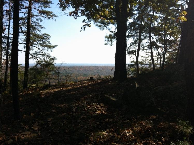
10 Paved road, which passes the paddle boat house on the way to the South Trailhead parking area. ~ 0.85 miles, watch for crowds (in the summer and weekends especially) and cars with distracted drivers on this road. Hiking Trails Distance: Other Information: Blue numbers: 1-26 (6.7 miles- one way) White numbers: (6.4 miles one way) Green numbers: (1.9 miles) Yellow numbers: (8 miles one way) Red numbers: (22 miles) 50 plus miles of trails Hiking Trails are marked as Red, White, Blue, Yellow, Green and Orange Trail Locations Red, White, Blue and Yellow begin at rth Trail Head (6 miles from front gate on John Findlay Dr. or miles from back entrance) Green Trail begins near Park Office on Terrace Drive Orange Trail is located on John Findlay near the Stables The trails (except orange and Wildlife Center trails) are equipped with a marking system designed to help Park staff cut down search time area when someone is hurt or lost. Each trail is uniquely colored and numbered, and do not repeat. The posts are placed approximately every ¼ mile. If lost or injured on the trail call the Park Office ( ) and indicate the number of the last post passed. Horseback Trails Guided Trails rides are available for purchase at the stables Wednesday through Sunday Minimum age 8 years old Reservations are recommended Hours of Operation are seasonal


11 Horse boarding also available. Check for rates There are currently 13 plus miles of horse trails for public use Photos: Blue Hiking Trail

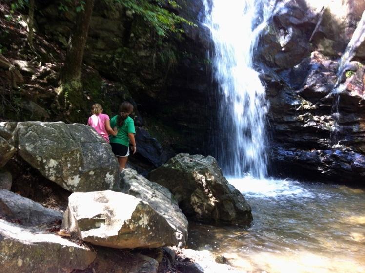
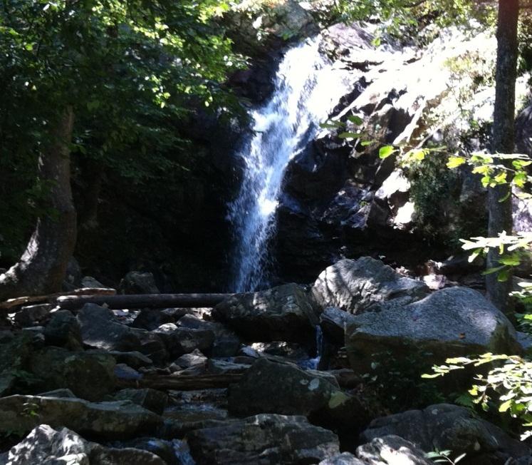
12 Peavine Falls
13 Map:
14
9. APPENDICES Disciplines of Mountain Biking
 9. APPENDICES 9.1. Disciplines of Mountain Biking Cross-country Cross-country mountain biking is the oldest discipline within the sport and is analogous to cross-country running or skiing. It involves
Calaveras Big Trees State Park--South Grove Loop
 Copyright 1999 by Jeff Robinson. You are free to use and reproduce this description for personal, not-for-profit, and not-forbusiness use. Any reproduction other than for personal use, including businesses,
LAKE TAHOE peopleforbikes.org/e-bikes
 emtb ADVENTURE MAPS LAKE TAHOE peopleforbikes.org/e-bikes OVERVIEW Lake Tahoe is an iconic destination for mountain biking. With crystal blue waters surrounded by mountain peaks on all sides, the area
2015 Brown County Epic Mountain Bike Festival General Information
 2015 Brown County Epic Mountain Bike Festival General Information Brown County Epic Registration Information * Changes in 2015 Epic Rides will take place on Saturday! Demos on Saturday and Sunday Registration
Trail Notes Local Mountain Bike Areas
 Trail Notes Local Mountain Bike Areas Campus Recreation 875 Perimeter Drive MS 1230 Moscow. Idaho 83844-1230 Ph: 208.885.6810 Rentals: 208.885.6170 Fax: 208.885.6879 uidaho.edu/outdoorprogram 1 Table of
2016 Brown County Epic Mountain Bike Festival General Information
 2016 Brown County Epic Mountain Bike Festival General Information Brown County Epic Registration Information *2016 Epic Rides will take place on Saturday again this year. Event camping offered Thursday
Pah Rah Mountain Range
 Pah Rah Mountain Range The Pah Rah Mountain Range is located east of the city of Sparks, and parallels Vista Boulevard. The mountain range originates at Interstate 80, and terminates at Pyramid Lake. Most
Douglas A. Ormseth Shortgrass Web Development
 Douglas A. Ormseth Shortgrass Web Development doug@shortgrass.com 406-261-1115 (Note: others have proposed some of these ideas already in the Black Eagle Community Visioning document and on the Rivers
THE FIRST MOUNTAIN BIKE TRAIL CENTRE IN THE GCC & MIDDLE EAST
 THE FIRST MOUNTAIN BIKE TRAIL CENTRE IN THE GCC & MIDDLE EAST INTRODUCTION WELCOME TO HATTA TRAIL CENTRE WEBSITE Hatta Trail Centre is a first MTB Centre in the Middle East, and is a home to multiple cross
LOCATION Machico, Madeira Island, Portugal REGISTRATION CATEGORIES PROTECTION RULES. Document created by MADproductions
 LOCATION Machico, Madeira Island, Portugal REGISTRATION CATEGORIES PROTECTION RULES COURSE DESCRIPTION By António Abreu, MADproductions LINK 1 (4,96km - 208hmm uphill - 11hm downhill) Start the race at
Fish Lake Team Relay Course Information 2016
 Fish Lake Team Relay Course Information 2016 Fish Lake Team Relay Course Information 2016 The Fish Lake Team Relay begins at Fish Lake Lodge on the shores of beautiful Fish Lake located in Sevier County,
HURL ELKHORN 50K RUN AID STATIONS COURSE MARKINGS
 HURL ELKHORN 50K RUN AID STATIONS The race starts and finishes at Crystal Creek Campground, where primitive camping is available. The race starts at 7:00 am. The finish cut off time is 9:00 pm. No drop
Detailed Descriptions and Maps of Woodside s Nature Trails
 Detailed Descriptions and Maps of Woodside s Nature Trails Access Mill Road Trail Park along Anderson Mill road. Signs on West Pleasant Colony and Anderson Mill road clearly point to the beginning of the
Ride Center Evaluation Criteria
 Ride Center Evaluation Criteria Singletrack Trail Mileage Minimum Qualifications Quality Trail Experience Objective Scoring Total Minimum Total Qualification Score Miles Kilometers Score Score Level Score
To Benefit the Wachusett Mountain Race Team!
 To Benefit the Wachusett Mountain Race Team! Handbook Outline: Race Overview & Events Schedule....3 Leg 1: 5-mile Run... 4 Leg 2: Scenic Bike Race.....5 Leg 3: Summit Climb......6 Leg 4: Ski Run...7 Application.....8
FOLLOW THE LEADER. Skills Bike control, stopping, starting, safe following distance, signaling, shoulder checking, using gears.
 FOLLOW THE LEADER Skills Bike control, stopping, starting, safe following distance, signaling, shoulder checking, using gears. Location Playground or basketball court. Set-up/Tools None. No cones or chalk
Canoe Trek Guide. Chief Pontiac Trail Credential Hikes
 Canoe Trek Guide Canoe Livery Start Edition Chief Pontiac Trail Credential Hikes RDS.CE.110609 WP# Dist. Accum. Dist. Accum. Feet Miles Meters Meters 1 0 0.0 0 0 2 410 0.1 125 125 3 1,115 0.3 340 465 4
2017 Big Woods Brown County Epic Mountain Bike Festival General Information
 2017 Big Woods Brown County Epic Mountain Bike Festival General Information Brown County Epic Registration Information Registration Includes: Free commemorative t-shirt Epic rides of up to 100 miles with
Eligibility: You must have completed at least one 100 Mile TRAIL RUN or a qualifying 50 Miler (see website for 50 mile qualifying events).
.") Cruel Jewel 100 Mile Course Description The Cruel Jewel 100 is a 108 mile foot race deep with in the beautiful Chattahoochee National Forest of the North Georgia Mountains. It consists of 95 miles of trails,
Cruel Jewel 100 Mile Course Description The Cruel Jewel 100 is a 108 mile foot race deep with in the beautiful Chattahoochee National Forest of the North Georgia Mountains. It consists of 95 miles of trails,
Hornsby Blue Gum Walk
 Hornsby Blue Gum Walk 3 hrs Hard track 6.7 km Circuit 4 374m This delightful loop is one of the prettiest and most popular walks in the Hornsby area. Going from an environment of ferns and clear bushland
Bureau of Land Management National Mountain Bike Action Plan
 Bureau of Land Management National Mountain Bike Action Plan IMBA World Summit, 2016 BLM National Mountain Bike Strategy (1992) National Mountain Bicycling Strategic Action Plan (2002) National Mountain
Fish Lake Team Relay Course Information
 Fish Lake Team Relay Course Information Fish Lake Team Relay Course Information The Fish Lake Team Relay begins at Fish Lake Lodge on the shores of beautiful Fish Lake located in Sevier County, Utah. The
Biking Trails near Invermere, BC. Lillean Lake Along the Johnson Bike Trails. Spirit Trail Columbia Lake
 Biking Trails near Invermere, BC Lillean Lake Along the Johnson Bike Trails - To get there: From Invermere, take the Panorama Road Mount Swansea Biking and Hiking Trails Spirit Trail Columbia Lake IMBA
Trail and Driving Directions
 Trail and Driving Directions GETTING TO THE START: FROM CADILLAC: Follow M-55 west from US131 for 20.9 miles to the corner of M-37 and M-55 FROM THE INTERSECTION OF M-55 AND M-37: Head west on M-55 2.7
I-5 Colonnade Mountain Bike Skills Park. Phase 2. High Level Design & Trail Standards
 I-5 Colonnade Mountain Bike Skills Park Phase 2 High Level Design & Trail Standards Table of Contents OVERVIEW... 3 INTRODUCTION...3 ACKNOWLEDGEMENTS... 3 PURPOSE AND SCOPE... 4 DESIGN FLEXIBILITY... 4
Leg #1 (GUNLOCK AND LOADED) Miles
 Miles") Leg #1 (GUNLOCK AND LOADED)- 6.07 Miles Difficulty: Easy to Moderate This is a nice leg for those who like running downhill. It s a beautiful run down the Santa Clara River canyon to the point where the
Leg #1 (GUNLOCK AND LOADED)- 6.07 Miles Difficulty: Easy to Moderate This is a nice leg for those who like running downhill. It s a beautiful run down the Santa Clara River canyon to the point where the
Falls Lake Trail (A part of the NC Mountains-to-Sea Trail) East to West
 East to West") Falls Lake Trail (A part of the NC Mountains-to-Sea Trail) East to West Section 1 (Falls of the Neuse Rd to Raven Ridge Rd) 0.0 mi Parking area of the Tailrace Fishing Area, just below the dam, off Falls
Falls Lake Trail (A part of the NC Mountains-to-Sea Trail) East to West Section 1 (Falls of the Neuse Rd to Raven Ridge Rd) 0.0 mi Parking area of the Tailrace Fishing Area, just below the dam, off Falls
Walk: NOC 08 Location: Cym Glyn near Brecon
 33 Walk: NOC 08 Location: Cym Glyn near Brecon Directions: Not easy to find at all. Go to Libanus, then head towards Brecon on the A470. Take minor C road single track lane first right as you come out
Go Mountain Bike. Riders Guide & Log Book MOUNTAIN BIKING PROFICIENCY AWARD
 Riders Guide & Log Book MOUNTAIN BIKING PROFICIENCY AWARD It s great to see something that mimics what all riders are out doing on the trails. is a great way to progress yourself, set your own goals and
RIDER PERFORMANCE PROFILE
 RIDER PERFORMANCE PROFILE NAME: DISCIPLINE: PRINCIPLE EVENT: COACH: DATE: Cycling Irel Long Term Athlete Development - Performance Profile CYCLING IRELAND RIDER PERFORMANCE PROFILE RIDER: Colour in the
UNH CYCLING Presents: ECCC Conference Championships at Highland Mountain Bike Park October 7 & 8, 2017
 UNH CYCLING Presents: ECCC Conference Championships at Highland Mountain Bike Park October 7 & 8, 2017 Promoter: Nate LaTourette ndl1002@wildcats.unh.edu Co-Promoter: Tim Putnam tjp1001@wildcats.unh.edu
Canoe Route. Dogtooth Lake-Highwind Lake-Dryberry Lake- Lake of the Woods-Blindfold Lake
 1 Canoe Route Dogtooth Lake-Highwind Lake-Dryberry Lake- Lake of the Woods-Blindfold Lake This is an interesting and challenging route starting and ending at Rushing River Provincial Park. It passes over
Falls Lake Trail (A part of the NC Mountains-to-Sea Trail) East to West
 East to West") Falls Lake Trail (A part of the NC Mountains-to-Sea Trail) East to West Section 1 (Falls of the Neuse Rd to Raven Ridge Rd) 0.0 mi Parking area of the Tailrace Fishing Area, just below the dam, off Falls
Falls Lake Trail (A part of the NC Mountains-to-Sea Trail) East to West Section 1 (Falls of the Neuse Rd to Raven Ridge Rd) 0.0 mi Parking area of the Tailrace Fishing Area, just below the dam, off Falls
2016 North Country Trail Relay Updated Event Instructions Jan 2016
 Welcome to the 2016 North Country Trail Relay (NCTR). organized by Bev Chesebro and Doug Bostian The race is run on the North Country National Scenic Trail, which is a footpath that one day will stretch
Helmet Check. Bike Check (A,B,C, Quick, Hand)
") Helmet Check Eyes Should be able to see edge of visor Ears Y of chin strap should fit just below ears Yawn Should be able to feel chin strap when yawning Snug Adjust fit around circumference of head using
Helmet Check Eyes Should be able to see edge of visor Ears Y of chin strap should fit just below ears Yawn Should be able to feel chin strap when yawning Snug Adjust fit around circumference of head using
Gravel Bike Guide Haywood County
 Gravel Bike Guide Haywood County Haywood County is an ideal place for bicycling on gravel roads, because 37% or 129,994 acres of Haywood County is federal property, including portions of the Pisgah National
Welcome to the 3 day Leadville Stage Race!
 Welcome to the 3 day Leadville Stage Race! This Year marks the 23rd anniversary of the first Leadville Trail 100 mountain bike race. We are excited to have you join us for the second year of this challenge.
Caerlee: Average Age = 6 (June 2017)
") Caerlee: Average Age = 6 (June 2017) Safety Able to follow M Check Take part in 10 minute blocks of cycling or coaching. Equity/ Social Able to interact and share with peers. Plays by the rules. Confident
Caerlee: Average Age = 6 (June 2017) Safety Able to follow M Check Take part in 10 minute blocks of cycling or coaching. Equity/ Social Able to interact and share with peers. Plays by the rules. Confident
BICYCLE RULES OF THE ROAD
 ILLINOIS ILLINOIS ILLINOIS ILLINOIS ILLINOIS ILLINOIS ILLINOIS ILLINOIS BICYCLE RULES OF THE ROAD Jesse White Secretary of State Bicycle riding is a great way to get into shape and enjoy the outdoors.
Please refer to the PMBIA manual, pages 48-77, for more detail on the following sections:
 Please refer to the PMBIA manual, pages 48-77, for more detail on the following sections: Outdoors for All Stand-up Mountain Bike 101 Session Lesson Plan Before the lesson: Contact registered participants
USA Cycling Mountain Bike Cross-country Marathon National Championships
 USA Cycling Mountain Bike Cross-country Marathon National Championships Tech Guide Columbia County, Georgia June 4, Held in conjunction with the Wildwood Games Rev. 6/2/16 Welcome to the USA Cycling Mountain
Group Riding Techniques
 Group Riding Techniques Revised: 2017 01 26 A. Group Riding Terminology Thanks to the Ottawa Bicycle Club for allowing us to use content from their website! A.1 Groups and Packs A group is several cyclists
Parental Responsibilities
 Bicycle riding is a fun way to exercise and enjoy the outdoors. To remain safe on Illinois roads, bicyclists must obey the same traffic safety laws that govern vehicle drivers. No amount of bicycle safety
MARITIME TRIATHLON RACE SITE PARKING
 BIKE OUT/IN Swim Start/Finish RUN OUT Speed bump PARKING MARITIME TRIATHLON RACE SITE *Special thanks to the Calhoon M.E.B.A. Engineering School for their generosity in allowing us to hold our event on
Tulsa Triathlon. Olympic Distance Course 2017
 Race Location Birch Lake in Barnsdall, OK, Twin Coves Area - Google Map Location Driving Directions from Tulsa: Take HWY 75N to OK-20 Collinsville/Skiatook exit Turn left onto OK-20 W/ E 146th St N (signs
Tulsa Triathlon Half Distance Course
 Race Location Birch Lake in Barnsdall, OK, Twin Coves Area - Google Map Location Driving Directions from Tulsa: Take HWY 75N to OK-20 Collinsville/Skiatook exit Turn left onto OK-20 W/ E 146th St N (signs
MOUNTAINS OF LAKE CREEK TBD LAKE CREEK RD. GORDON, TX
 MOUNTAINS OF LAKE CREEK TBD LAKE CREEK RD. GORDON, TX Palo Pinto Mountains Honey Creek Ridge Top Views Up to 195 Elevation Change Abundant Wildlife Mixed Hardwoods and Mesquite for Wildlife $52,500 - $343,000
Heathcote to Engadine via Audley
 Heathcote to Engadine via Audley 6 hrs 3 mins 5 km One way Hard track 4 635m Covering a large section of central Royal National Park, this walk goes through the heath and scrub along a well managed and
NEVADA BICYCLING GUIDE
 NEVADA BICYCLING GUIDE BE BICYCLE SAFE EVERY TIME YOU RIDE LET S ALL BE SAFE TOGETHER. In Case of Emergency Contact: Name: Phone: Relationship: REMEMBER TO ALWAYS, BE SAFE AND BE SEEN! Before you head
Ft. Tuthill Bike Park. design proposal
 Ft. Tuthill Bike Park design proposal What is this? A bicycle skills park is specially designed to provide riders a place to practice skills, learn to jump, have fun on mountain bikes, and watch and encourage
2015 Hertfordshire Triathlon Summer Sunday 30 th August
 Dear Race Entrant, Race Details This is your race information pack for the Hertfordshire Triathlon Summer and the Hetfordshire Triathlon Club Champs. ActiveTrainingWorld would like to thank Triathlon Zone,
Hunters Hill to Epping Road
 Hunters Hill to Epping Road 2 hrs 30 mins 5.5 km One way Moderate track 154m An enjoyable walk through lower sections of the Lane Cove National Park, this walk features plenty of mangroves next to the
THE WELLDIGGERS ARMS, HESWORTH AND FITTLEWORTH TRAIL
 THE WELLDIGGERS ARMS, HESWORTH AND FITTLEWORTH TRAIL 5.5 miles Circular 3 hours 041017 Challenging Terrain A 300-year-old pub turned country-inn on the edge of the South Downs National Park, The Welldiggers
Wattamolla to Big Marley Beach
 Wattamolla to Big Marley Beach 4 hrs 10.4 km Circuit Moderate track 4m This walk is an excellent loop which takes in both the coast and the heathy inland of Royal National Park. Nearly the whole walk has
2016 Hertfordshire Triathlon Spring Sunday 28 th August
 Dear Race Entrant, Race Details This is your race information pack for the Hertfordshire Triathlon Spring and the Hertfordshire Triathlon Club Champs. ActiveTrainingWorld would like to thank Moveology,
COMPETITOR INFO PACK. Page 1
 2016 COMPETITOR INFO PACK Page 1 3 Page 2 75k 50k 25k Race start time 75km Competitors & Teams Race Start: 8am Briefing: 7:45am 50km Competitors Race Start: 9am Briefing: 8:45am 25km Competitors Race Start:
Roads Main trails on this map include; to download this map or Map 1 and track notes
 Derby & Blue Tier Tier Mountain Mountain Bike Trails Trails, ails, Bush Tracks & Access Roads Roads Main trails on this map include; www.visitbluederby.com.au to download this map or Map 1 and track notes
About The Big Bend Open Road Race U.S 285 Course Notes
 2018 About The Big Bend Open Road Race U.S 285 Course Notes Course notes for 2018, Ft. Stockton to Sanderson and return. * Please note that these course notes are based on the 2017 race. You will notice
ADJUSTING TO, FOLLOWING, AND MEETING URBAN TRAFFIC
 Lesson 4 Student Notes 1 ADJUSTING TO, FOLLOWING, AND MEETING URBAN TRAFFIC 1. What two main factors make city driving difficult? There are more cars, buses, trucks, and pedestrians per mile. City hazards
Navigating Briones: getting around an advanced orienteering course. Brown Course, October 2011.
 Navigating Briones: getting around an advanced orienteering course. Brown Course, October 2011. The trek to the start this year wasn t short and boy was it steep. But this should be treated as an opportunity
PARTICIPANT GUIDE 2018 TO THE 25 th ANNUAL EVENT!
 PARTICIPANT GUIDE 2018 TO THE 25 th ANNUAL EVENT! GETTING HERE Find US-41 and head north. Yup, just head north. US-41 ends/begins in Copper Harbor. The main trailhead is right in the middle of town next
RULES FOR MOUNTAIN BIKE ORIENTEERING
 RULES FOR MOUNTAIN BIKE ORIENTEERING Version 2012b April 2012 This second version of MTBO Rules for New Zealand has been developed by the NZOF MTBO Committee and updated twice after the 2012 Otago Carnival
Chapter 11 Highway and Rural Driving
 Chapter 11 Highway and Rural Driving 11-1 THE RURAL DRIVING ENVIRONMENT A. Complete each of the following sentences by writing the correct word or phrase in the space provided. 1. The most heavily traveled
2009 Michaux Dual Sport Nation s Oldest Dual Sport
 2009 Michaux Dual Sport Nation s Oldest Dual Sport Welcome to the 21 st running of the Michaux Dual Sport Start/Finish: The Start/Finish will be where it was when people knew what a leading link front
MOUNTAIN BIKE ORIENTEERING RULES
 MOUNTAIN BIKE ORIENTEERING RULES This third version of MTBO Rules for New Zealand has been developed by the Orienteering NZ MTBO Committee and revised after the Otago and Woodhill2Whaka Carnivals. These
Team Pit Set-up Teams may set up their pits starting Saturday at 11:00 am. Pre-Ride Saturday and Sunday. Race Day Support. Volunteering at our Events
 RACE 3 Browns Creek April 27-28, 2019 1910 E Broad St, Elizabethtown, NC 28337 Race Description Singletracks.com states that Browns Creek has everything your looking for in a bike trail. Punchy climbs,
May 19, 2018 RADIO OPERATIONS PLAN
 PACIFIC CREST TRAIL 50 MILE RUN May 19, 2018 RADIO OPERATIONS PLAN Run Website - http://www.pct50.com/ Race Director - John Martinez Communications Coordinator - Craig Williams W6CAW. 619-806-4146 craig@craigwilliams.com
Course Maps Preliminary Version Awaiting final confirmation of construction on Rt. 100 June 19 Version
 Course Maps 2018 Preliminary Version Awaiting final confirmation of construction on Rt. 100 June 19 Version LEG #1- TRAIL MAP DESCRIPTION The runner lucky enough to start the race for their team immediately
Heartwood Forest, in Sandridge, Hertfordshire, is a place where everyone can find space, peace, wildlife and miles of beautiful woodland to explore.
 Heartwood Forest Accessibility Statement September 2016 Purpose: This accessibility statement outlines the available facilities and access information for Heartwood Forest. Welcome We, the Woodland Trust,
Broaddus Loop. Lufkin & Angelina County Bicycle Route. Total Miles:
 Lufkin & Angelina County Bicycle Route Total Miles: 72.6 www.visitlufkin.com Route Directions: Segment Distance Direction of Total Distance Road Traveled (miles) Turn (miles) Start Lufkin High School
OPSF Participant Guide 2019
 OPSF Participant Guide 2019 TABLE OF CONTENTS Welcome Organization History Location Schedule of Events Friday, March 22, 2019 Saturday, March 23, 2019 Race Rules Parking Race Information Start Times Distances
Wentworth Falls Conservation Hut Loop
 Wentworth Falls Conservation Hut Loop 3 hrs Hard track 6.7 km Circuit 4 341m This scenic walk from Wentworth Falls Station, winds along the Nature Trail to Conservation Hut, then drops into the magnificent
Traffic Signs and Signals
 CHAPTER FOUR Traffic Signs and Signals Traffic signs control traffic flow, making streets and highways safer for drivers, bicyclists and pedestrians. These signs, which are posted by the Indiana Department
Queen Creek Canyon. Guidebooks The Rock Jocks Guide to Queens Creek Canyon by Marty Karabin Jr.
 is one of Arizona s best winter climbing destination. The area is about 1 1/2 hours east of hoenix and elevation is around 4000 feet. The rock is a thick formation of ash that was deposited between 15
Start / Finish. Version 2
 Start / Finish Version 2 Gosford (Start) to Woy Woy Head South down Etna Street, crossing Henry Parry Drive, then Mann St, Gosford, where Etna St becomes Racecourse Road. Follow this road all the way
Winterfold Wood. point your feet on a new path. In Brief
 point your feet on a new path Winterfold Wood Distance: 8½ km=5¼ miles Region: Surrey Author: Schwebefuss Refreshments: Windmill Inn, Peaslake after the walk moderate walking with many gradients Date written:
Carrington Park to Leura Forest and pass loop
 Carrington Park to Leura Forest and pass loop 3 hrs Hard track 4.8 km Circuit 4 674m This walk is a fantastic way to see Leura Forest. The walk descends from Carrington Park, visiting Leura Forest and
ALL THE WAY: A VALLEY FOR BIKERS
 ÖTZTAL ON BIKE As an Ötztaler you do, of course, know that the world gets more and more beautiful the higher you get. That s why we not only spend our maximum of time outside, but also on the way up all
NEWLANDS CORNER AND ST MARTHAS
 NEWLANDS CORNER AND ST MARTHAS 10k CIRCULAR ROUTE 2½-3HRS GU4 8SE From Newlands Corner on the North Downs just outside Guildford, you can enjoy one of the most beautiful panoramas of quintessential English
Androscoggin River Trail Access Sites. Mahoosucs. 168 miles from its source at Lake Umbagog to Merrymeeting Bay
 Androscoggin River Trail Access Sites Mahoosucs 168 miles from its source at Lake Umbagog to Merrymeeting Bay Trail Under Construction More than 40 Public Access Sites Available Androscoggin River Watershed
RACE BOOK. Round California Enduro Series Battle Born Enduro Reno, NV May 14, 2016
 RACE BOOK Round 2 2016 California Enduro Series Battle Born Enduro Reno, NV May 14, 2016 Location Rancho San Rafael Regional Park 1595 N. Sierra Street Reno, NV 89503 Address does not always work in mapping
Floating the Buffalo National River. with First River Outfitter. Michelle Hulett. exp2010_w01h3buffalo2_ann_solution
 Floating the Buffalo National River with First River Outfitter Michelle Hulett The Buffalo River Beginning as just a trickle, The Buffalo National River runs down the Boston Mountains, flows north and
XC Eliminator Rules, Regs & Info
 XC Eliminator Rules, Regs & Info Race Format The XC Eliminator is a race tournament where four riders race side by side on a short cross-country mountain bike course. Each race consists of a single lap
27th Annual Huntington's Disease Triathlon
 27th Annual Huntington's Disease Triathlon JULY 29, 2018 ATHLETE GUIDE 2 Date: Sunday, July 29 th, 2018 Venue: Larry and Penny Thompson Park 12451 SW 184 Street Miami, FL 33177 Distance: Sprint (.25 mile
Signs. signs, signals and road markings. in this chapter
 3 signs, signals and road markings in this chapter Signs regulatory signs school, playground and crosswalk signs lane use signs turn control signs parking signs reserved lane signs warning signs object
Maintenance. Maintenance. Design. Construction. Planning. Bike-Friendly Techniques. PNW Techniques. Tools, Special Considerations
 Maintenance Planning Design Construction Maintenance Objectives: Style, Audience, Skill Level, Connections Bike-Specific vs. Bike- Friendly Multi-Use Resources, Funding, Volunteers Permission, Permitting,
Team Pit Set-up Teams may set up their pits starting Saturday at 10:00 am. Pre-Ride Saturday and Sunday. Race Day Support. Volunteering at our Events
 RACE 3 Bigleaf Slopes April 6-7, 2019 341 Twin Oaks Rd, Statesville, NC 28625 Race Description Bigleaf Slopes will challenge riders with twisty singletrack with narrow sections and they descend from the
WELCOME TO BMX AUSTRALIA
 WELCOME TO BMX AUSTRALIA THE FASTEST GROWING SPORT IN AUSTRALIA BMX (Bicycle Moto Cross) is one of the fastest growing sports in Australia. It is one of the only sports where total family participation
California DMV Test. Mark the correct answers
 California DMV Test Mark the correct answers 1. When you leave your lane to pass another vehicle, you know you have enough room to return to your driving lane when you: Have passed the other vehicle's
VELINDRE VALLEYS WALK FOR STEFFAN
 VELINDRE VALLEYS WALK FOR STEFFAN IMPORTANT INFORMATION FOR WALKERS AND MARSHALS 1 Table of Contents Key Contact Numbers:... 3 Timetable and locations... 4 T-shirts... 4 Important Advice for Walkers...
STAFF REPORT. Meeting Date: March 1, 2017 Agenda Item 5B
 Meeting Date: March 1, 2017 Agenda Item 5B STAFF REPORT Agency: Staff Contact: Agenda Title: Agenda Action: City of Belmont, Parks & Recreation Commission Jonathan Gervais, Parks & Recreation Director,
MMT 100 Crew Instructions
 MMT 100 Crew Instructions Updated for the 2018 Event While crews are welcome at the MMT, they can cause congestion and related problems. Crews must comply with the provisions on this page. Race management
laws AnD rules of the road ight-of-way rules General Information Respect Respecting respect Pedestrians Important:
 LAWS AND RULES OF THE ROAD Right-of-Way Rules General Information Right-of-way rules, together with courtesy and common sense, help to promote traffic safety. It is important to respect the right-of-way
Williams Lake WestSyde Trail Network
 Williams Lake WestSyde Trail Network This is an intermediate to advanced network with many beginner options. The Westside network has 40 trails with over 97Km of singletrack, including the legendary Box
Echo Point to Leura Forest via Three Sisters and Giant Stairs loop
 Echo Point to Leura Forest via Three Sisters and Giant Stairs loop 3 hrs 3.8 km Circuit Hard track 512m This walk starts from the popular Echo Point, in Katoomba, and winds down to the base of the Three
STAGE #3 TRANSITION 1 at Camp Keystone
 STAGE #3 SWIM STAGE #3 TRANSITION 1 at Camp Keystone Mount bike AFTER bump T1 Changing Tent STAGE #3 Camp Keystone to Marineland 68 MILE BIKE STAGE #3 68 MILE BIKE Mile 0-10 SAG 0.0 Turn RIGHT out of T1.
Welcome. You ve joined a growing joy-driven movement in cycling. We re so glad to have you here. INTRO PREP DAY 1 DAY 2 DAY 3 DAY 4 RIDE MORE
 Welcome. You ve joined a growing joy-driven movement in cycling. We re so glad to have you here. It s like falling in love. We joke that bonding with a Cruzbike is like falling in love. And it is. The
BSA Cycling Merit Badge. Created: April 2017 Updated: May 2017
 BSA Cycling Merit Badge Created: April 2017 Updated: May 2017 MB Counselor Cycling Merit Badge Dan Marsalek 7247 Tottenham Rd. Toledo, Ohio 43617 Cell: 419-279-0217 E-Mail: DMarsalek@hotmail.com Schedule
RAMS FORM. Date: Sunday 7th May The event consists of a short duration (approx 1 to 1.5 hour) Cross Country mountain bike race.
 Cross Country mountain bike race.") RAMS FORM Activity: Race 1 of the Auckland Secondary school Series of Mountain Bike Cross Country Races hosted by Jafakids for Auckland Secondary Schools. The aim is to improve the riding skills of Auckland
RAMS FORM Activity: Race 1 of the Auckland Secondary school Series of Mountain Bike Cross Country Races hosted by Jafakids for Auckland Secondary Schools. The aim is to improve the riding skills of Auckland
Bike Safety It Starts With You!
 The law defines the bicycle as a vehicle that belongs on the road. Riding on the road means that you are mixing with other traffic, and it is only safe when all vehicles in traffic use the same rules of