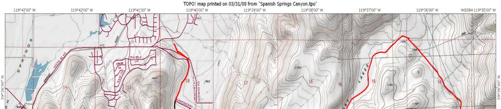
Pah Rah Mountain Range
|
|
|
- Katherine Terry
- 6 years ago
- Views:
Transcription

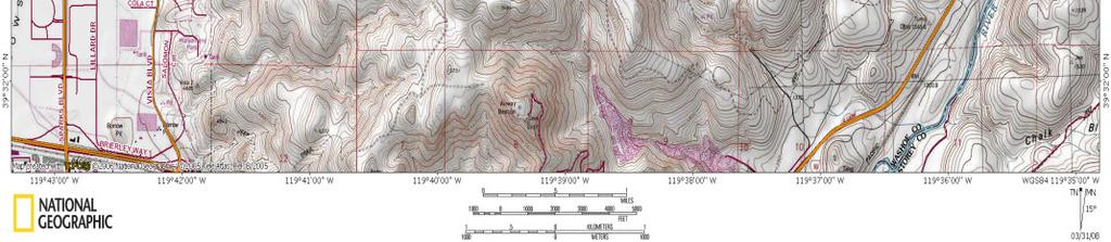
1 Pah Rah Mountain Range The Pah Rah Mountain Range is located east of the city of Sparks, and parallels Vista Boulevard. The mountain range originates at Interstate 80, and terminates at Pyramid Lake. Most of the riding in this range is jeep road. There is a little single track, but not much. This is also one of the rockiest areas that I have ever been. My personal feeling is that if you can ride this area well, you can ride anywhere. The Pah Rah range has much to offer. The views are all unobstructed, there are deer, antelope, coyotes, mountain lions, and golden eagles. So keep your eyes open. There are also many ancient Indian petroglyphs scattered throughout this range. So take lots of water, and a couple of extra tubes for pinch flats.

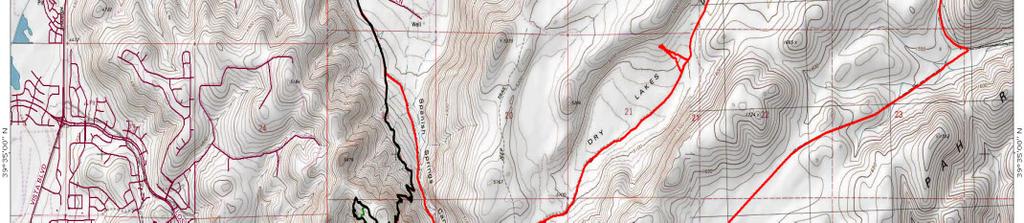
2 Spanish Springs Canyon to the Dry Lake Petroglyphs (Red Trail) 11.5 miles 910 feet of climbing (Intermediate) This ride is very rocky and best suited for the intermediate rider. However, this is a great outing for the high clearance vehicle and the entire family. Take Interstate 80 east to the city of Sparks, and take the Vista Boulevard exit. Take a left on Vista Boulevard. Follow Vista Blvd. just past Red Hawk Golf Course. You will pass the golf course entrance on your left. Continue east on Vista Blvd and you will see a dirt road on your right. Most people miss this road, so if you do, continue east on Vista. You will have a couple of dirt road options on your right. All will lead up Spanish Springs Canyon which you can now see on your right. This is a north south canyon. Park on any of the dirt roads and ride south. You will immediately hit the main dirt road. Take a right and follow this dirt road to your first right. This right is your only choice up the canyon, and if you miss it, you will end up at a ranch. So turn around and take the road you missed. From here, follow this public access road up Spanish Spring Canyon for 1.4 miles where you will see a single track come in on your right. This is the return single track for the Spanish Springs Canyon Single Track Loop. Continue south on the main road, and in 1.8 miles (3.2 miles from the start) you will come to a Y intersection. Stay to the left, and yes, that is your climb in front of you. It is steep, rocky, and loose. However, once to the top the worst is over. So stay to the left, and in.5 miles (3.7 miles) you will come to another intersection. The left will take you out onto another dry lakebed, and dead end at the far north end. So stay strait, east, and follow the road east where it will drop into a lower dry lakebed and take a turn heading north. Continue on this road and in 2.55 miles from the top of the ridge (5.75 miles) you will be at your turn around point. From here, you have just started to climb out of the lower dry lake bed, and are just short of the ridge that drops into the upper dry lakebed. If you look left (west) you will see a scattering of rocks. You need to hike to the largest rock pile that you see. This pile is not quite to the rim rock of the ridge. So drop your bikes off of the road and hike.25 miles to the rocks. This is one of the largest collections of petroglyphs in the area. From this point you can hike around and explore, continue the entire Spanish Springs Pipeline Road Loop, or just hike back to the bikes and retrace your path 5.75 miles (11.5 miles) back to your car. Be careful for pinch flats on the down hills.
 For this ride, follow the directions for the Spanish Springs Canyon to the Dry Lake Petroglyphs ride.")
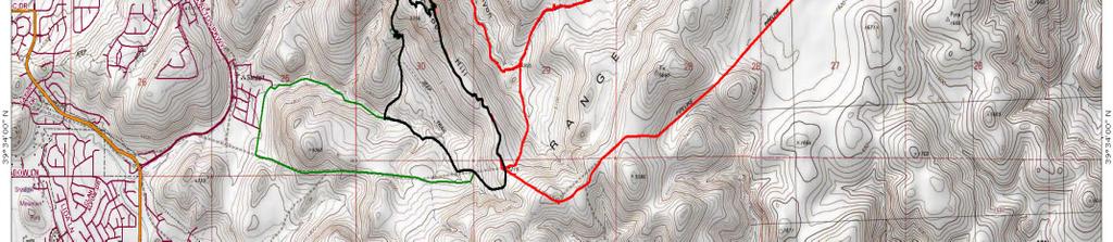
3 Spanish Springs Pipeline Road Loop (Red to Black) 19.5 miles 1470 feet of climbing (Strong Intermediate) For this ride, follow the directions for the Spanish Springs Canyon to the Dry Lake Petroglyphs ride. From the petroglyphs, continue north over the ridge and into the lower dry lake bed. From the petroglyphs, you will travel 2.1 miles (7.85 miles from the start) where the jeep road will take a turn to the right (east.) You will encounter a couple of roads to your right, but ignore those and continue east down the draw for 2.05 miles (9.9 miles) where you will come to a T intersection. If you go left you can drop out at Tracey Power Plant on the Truckee River. However, for this ride, take a right and head west. Follow this road for 1.5 miles (11.4 miles) where you will crest the climb, then drop into yet another dry lake bed. During the winter months, I have seen herds of over 60 antelope in this dry lake bed. However, continue from the ridge for 2 miles (13.4 miles) where you will climb out of the lake bed onto another ridge. Follow the road for.8 miles (14.2 miles) where you will end another climb. Congratulations, most of your climbing is done. Continue west for 1.3 miles (15.5 miles) where you have an option. If you take a hard right, you will drop down Spanish Springs Canyon back to your car. If you go strait west, you may drop out at Pah Rah Park on Vista Blvd. Problem here is that the construction tends to block this path. Your last choice is to take the single track on the ridge heading north, on the ridge to the west of Spanish Springs Canyon. Please note, this single track is very technical and for the expert rider only. So, take a right and be very careful on this down hill. It is very loose and rocky. Watch your speed. Continue north for.75 miles (16.25 miles) where you will be back on the main Spanish Springs Canyon jeep road. At this intersection, take a left and follow this jeep road for 3.2 miles (19.5 miles) where you will be back at your car.
 This is one of the most technical single tracks that I have ever been on.")


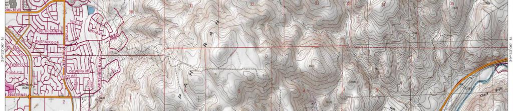
4 Spanish Springs Canyon Single Track Loop (Black Trail) 7.91 miles 1400 ft. of climbing (Advanced) This is one of the most technical single tracks that I have ever been on. It is not a single track that will break you, rather it forces you to go slow, and rely on strength, balance, and ability. This single track is very rocky, and has some of the tightest switch backs that I have ever been on. It is completely rideable both directions up and down, but quite the challenge. This ride follows the start of both of the previous rides. So, follow the main jeep road south up the canyon and in 1.4 miles you will see a single track come in on your right. Take this singletrack and follow it parallel to the jeep road to the north. The singletrack gradually climbs till mile marker 1.25 miles. This is where the climb begins. The trail starts to climb quickly to the west. The switchbacks are tight but can be ridden. Follow the singletrack uphill for.84 miles (2.09 miles from the start) where you will crest the ridge. The worst of the climbing is now over. But remember, this
 you will be on top of the ridge, and you have a long downhill in front of you. Once on the ridge, the trail turns northerly, and continues along the ridge, and in.32 miles (2.")

5 is also your downhill. At this ridge, you will see your return singletrack to the left, here you need to take a right and follow the singletrack uphill to the west. This climb is short and simple. In.10 miles (2.19 miles) you will be on top of the ridge, and you have a long downhill in front of you. Once on the ridge, the trail turns northerly, and continues along the ridge, and in.32 miles (2.51 miles) you have an option. You are at a Y intersection in the singletrack. The left singletrack cuts down to the lower singletrack as a shortcut, and cuts out the very rocky and technical section to the north. For this ride, I am going to assume that you are an advanced rider, so continue strait to the north along the ridge, and in.10 miles (2.61 miles) the trail cuts back to the south and gets very rocky and steep. See pic. to the left and right. The trail continues south winding through the rocks, and in.22 miles (2.83 miles) you will see your shortcut singletrack on the left. Continue south on the singletrack and again, you will wind through another rocky section, then the trail will open out on the side hill, and in.21 miles (3.04 miles) you will cross over a dirt road, and the singletrack will pick up again on the south side of the road. Continue to the south on the singletrack and you will switchback down the side of the hill. Then in.38 miles (3.42 miles) you will cross over another faint jeep road, and the singletrack will drop south down the wash. In.35 miles (3.77 miles) the singletrack will drop out of the wash and onto another faint jeep road. If you go left the trail will drop you out in the housing development above Los Altos Parkway. Take a right and start the climb back up to the left. Follow this faint jeep road that has now turned into more of a singletrack for.73 miles (4.5 miles) where the singletrack will cross Pipeline Road. The singletrack picks up on the south side of Pipeline Road and parallels Pipeline Road for a short distance then turns south and climbs up to the saddle above. In.33 miles (4.83 miles) the singletrack will again cross over Pipeline Road. The singletrack picks up directly across pipeline road on the north side. Here the singletrack just climbs up the ridge to the north. It is a little rocky in places, but not as bad as anything else you have already been over. Continue up the ridge to the north, and in 1.05 miles (5.88 miles) you will be back at the intersection of your return singletrack. This downhill singletrack is the same one you came up earlier. Please be very careful on this downhill, take it slow and easy in the switchbacks. Continue to retrace your singletrack 2.03 miles (7.91 miles) back to your car.
6
Explore the outdoors in Shelby County
 Explore the outdoors in Shelby County Oak Mountain Trail GPS: 33.283831-86.865238 Trail Location: Address: Oak Mountain State Park Trail 200 Terrace Drive Pelham, AL 35124 Type of Trail: Walking, Mountain
HURL ELKHORN 50K RUN AID STATIONS COURSE MARKINGS
 HURL ELKHORN 50K RUN AID STATIONS The race starts and finishes at Crystal Creek Campground, where primitive camping is available. The race starts at 7:00 am. The finish cut off time is 9:00 pm. No drop
LAKE TAHOE peopleforbikes.org/e-bikes
 emtb ADVENTURE MAPS LAKE TAHOE peopleforbikes.org/e-bikes OVERVIEW Lake Tahoe is an iconic destination for mountain biking. With crystal blue waters surrounded by mountain peaks on all sides, the area
THE FIRST MOUNTAIN BIKE TRAIL CENTRE IN THE GCC & MIDDLE EAST
 THE FIRST MOUNTAIN BIKE TRAIL CENTRE IN THE GCC & MIDDLE EAST INTRODUCTION WELCOME TO HATTA TRAIL CENTRE WEBSITE Hatta Trail Centre is a first MTB Centre in the Middle East, and is a home to multiple cross
Owyhee Hikes February & April, 2009
 Owyhee Hikes February & April, 2009 I did a 22 mile loop hike along the Snake River at Swan Falls to view petroglyphs and to find locations to fish for Bass, Catfish and Crappie later in the summer. I
Fish Lake Team Relay Course Information 2016
 Fish Lake Team Relay Course Information 2016 Fish Lake Team Relay Course Information 2016 The Fish Lake Team Relay begins at Fish Lake Lodge on the shores of beautiful Fish Lake located in Sevier County,
Calaveras Big Trees State Park--South Grove Loop
 Copyright 1999 by Jeff Robinson. You are free to use and reproduce this description for personal, not-for-profit, and not-forbusiness use. Any reproduction other than for personal use, including businesses,
Welcome to the 3 day Leadville Stage Race!
 Welcome to the 3 day Leadville Stage Race! This Year marks the 23rd anniversary of the first Leadville Trail 100 mountain bike race. We are excited to have you join us for the second year of this challenge.
Fish Lake Team Relay Course Information
 Fish Lake Team Relay Course Information Fish Lake Team Relay Course Information The Fish Lake Team Relay begins at Fish Lake Lodge on the shores of beautiful Fish Lake located in Sevier County, Utah. The
Trail Notes Local Mountain Bike Areas
 Trail Notes Local Mountain Bike Areas Campus Recreation 875 Perimeter Drive MS 1230 Moscow. Idaho 83844-1230 Ph: 208.885.6810 Rentals: 208.885.6170 Fax: 208.885.6879 uidaho.edu/outdoorprogram 1 Table of
La Madre Wilderness Area
 La Madre Wilderness Area Rock Climbing Inventory Statistics: Area: Walls La Madre North 3 24 136 22 Kraft Mt./Gateway Canyon White Rock Springs Willow Springs East The Promised Land 18 4 3 3 12 23 11 24
Colorado Rocky Mountains Tour
 BikePlusTours Performance Cycling Trips Colorado Rocky Mountains Tour A Breathtaking Experience Our Colorado Rocky Mountains Tour gives you the opportunity to ride on some of North America's highest roads
Gravel Bike Guide Haywood County
 Gravel Bike Guide Haywood County Haywood County is an ideal place for bicycling on gravel roads, because 37% or 129,994 acres of Haywood County is federal property, including portions of the Pisgah National
Helmet Check. Bike Check (A,B,C, Quick, Hand)
") Helmet Check Eyes Should be able to see edge of visor Ears Y of chin strap should fit just below ears Yawn Should be able to feel chin strap when yawning Snug Adjust fit around circumference of head using
Helmet Check Eyes Should be able to see edge of visor Ears Y of chin strap should fit just below ears Yawn Should be able to feel chin strap when yawning Snug Adjust fit around circumference of head using
Module 5: Navigating Roadways
 Module 5: Navigating Roadways Topic 1: Intersections 1. One out of FATAL crashes occur at intersections. 2. Label the intersection warning signs: 3. When possible, begin searching seconds ahead of the
Coyote Buttes/The Waves
 Coyote Buttes/The Waves Ron Ross December 22, 2007 Coyote Buttes is located in the Paria Canyon-Vermilion Cliffs Wilderness just south of US 89 about halfway between Kanab, Utah and Page, Arizona. The
Williams Lake WestSyde Trail Network
 Williams Lake WestSyde Trail Network This is an intermediate to advanced network with many beginner options. The Westside network has 40 trails with over 97Km of singletrack, including the legendary Box
Detailed Descriptions and Maps of Woodside s Nature Trails
 Detailed Descriptions and Maps of Woodside s Nature Trails Access Mill Road Trail Park along Anderson Mill road. Signs on West Pleasant Colony and Anderson Mill road clearly point to the beginning of the
To Benefit the Wachusett Mountain Race Team!
 To Benefit the Wachusett Mountain Race Team! Handbook Outline: Race Overview & Events Schedule....3 Leg 1: 5-mile Run... 4 Leg 2: Scenic Bike Race.....5 Leg 3: Summit Climb......6 Leg 4: Ski Run...7 Application.....8
Wentworth Falls Conservation Hut Loop
 Wentworth Falls Conservation Hut Loop 3 hrs Hard track 6.7 km Circuit 4 341m This scenic walk from Wentworth Falls Station, winds along the Nature Trail to Conservation Hut, then drops into the magnificent
LOCATION Machico, Madeira Island, Portugal REGISTRATION CATEGORIES PROTECTION RULES. Document created by MADproductions
 LOCATION Machico, Madeira Island, Portugal REGISTRATION CATEGORIES PROTECTION RULES COURSE DESCRIPTION By António Abreu, MADproductions LINK 1 (4,96km - 208hmm uphill - 11hm downhill) Start the race at
T R A F F I C S K IL L S 101
 page 1/5 GENERAL INSTRUCTIONS Mark your answers on the answer sheet provided. DO NOT make any marks on the test. Please read the following definitions and assumptions carefully before answering the test
Traffic Signs and Signals
 CHAPTER FOUR Traffic Signs and Signals Traffic signs control traffic flow, making streets and highways safer for drivers, bicyclists and pedestrians. These signs, which are posted by the Indiana Department
About The Big Bend Open Road Race U.S 285 Course Notes
 2018 About The Big Bend Open Road Race U.S 285 Course Notes Course notes for 2018, Ft. Stockton to Sanderson and return. * Please note that these course notes are based on the 2017 race. You will notice
BSA Cycling Merit Badge. Created: April 2017 Updated: May 2017
 BSA Cycling Merit Badge Created: April 2017 Updated: May 2017 MB Counselor Cycling Merit Badge Dan Marsalek 7247 Tottenham Rd. Toledo, Ohio 43617 Cell: 419-279-0217 E-Mail: DMarsalek@hotmail.com Schedule
SOUTH MOUNTAIN TRAILS - THE DEFINITIVE GUIDE Lehigh University, Bethlehem PA. By Daniel McCauley
 SOUTH MOUNTAIN TRAILS - THE DEFINITIVE GUIDE Lehigh University, Bethlehem PA By Daniel McCauley DESCRIPTION: The South Mountain Trail Network is an extensive network of intermediate jeep roads to extreme
Commitment like this is hard to find. Thank you for riding with us in Leadville!
 Welcome to the 3 day Leadville Stage Race! This Year marks the 23rd anniversary of the first Leadville Trail 100 mountain bike race. We are excited to have you join us for the second year of this challenge.
Utah. North Stansbury Mountains Wilderness Study Area Site-Specific Monitoring Guide
 Utah North Stansbury Mountains Wilderness Study Area Site-Specific Monitoring Guide 1 General Information WildSNAP Monitoring Peter Woodruff, American Conservation Experience Coordinator Phone (801) 989-7069
Welcome to the zwitty ultra guide to running the styr labs badwater 135 ultramarathon As fast as you possibly can!!!
 Welcome to the zwitty ultra guide to running the styr labs badwater 135 ultramarathon As fast as you possibly can!!! (OVERVIEW MAP) Section 8: lone pine to finish (122.4-134.2): this section is 11.8 miles.
29 th Annual Army Spring Classic United States Military Academy
 29 th Annual Army Spring Classic United States Military Academy West Point, New York April 13 th and 14 th 2013 Pre-Registration: *Register at Bike Reg.com (Preferred method).* E-Mail: Jennifer.Webster@usma.edu
Dead Horse Gap Loop track
 Dead Horse Gap Loop track 4 hrs 30 mins Hard track 9.8 km Circuit 144m 4 This walk starts with a ride up the Kosciuszko Express Chairlift. There is an opportunity to eat at Australia's highest restaurant,
Biking Trails near Invermere, BC. Lillean Lake Along the Johnson Bike Trails. Spirit Trail Columbia Lake
 Biking Trails near Invermere, BC Lillean Lake Along the Johnson Bike Trails - To get there: From Invermere, take the Panorama Road Mount Swansea Biking and Hiking Trails Spirit Trail Columbia Lake IMBA
Leg #1 (GUNLOCK AND LOADED) Miles
 Miles") Leg #1 (GUNLOCK AND LOADED)- 6.07 Miles Difficulty: Easy to Moderate This is a nice leg for those who like running downhill. It s a beautiful run down the Santa Clara River canyon to the point where the
Leg #1 (GUNLOCK AND LOADED)- 6.07 Miles Difficulty: Easy to Moderate This is a nice leg for those who like running downhill. It s a beautiful run down the Santa Clara River canyon to the point where the
Please refer to the PMBIA manual, pages 48-77, for more detail on the following sections:
 Please refer to the PMBIA manual, pages 48-77, for more detail on the following sections: Outdoors for All Stand-up Mountain Bike 101 Session Lesson Plan Before the lesson: Contact registered participants
2017 Racer Manual Desert RATS mtb Classic
 2017 Racer Manual Desert RATS mtb Classic May 13, 2017 Fruita, CO Hello Racers and Crews! We can t wait to see all of you this May - hopefully with fresh legs and a powerful spirit, ready to start the
2017 Crew Manual Alternate Route Race Day - February 18, 2017
 2017 Crew Manual Alternate Route Race Day - February 18, 2017 Crew Rules Crewing is a privilege not a right at this race. We ask that you follow these simple rules to help keep our race safe and enjoyable
CYCLING - Mountain Bike Page 1
 CYCLING - Mountain Bike - 2019 - Page 1 GUIDING BODIES World Police and Fire Games Federation (WPFGF) 8304 Clairemont Mesa Blvd., # 107, San Diego, CA 92111 USA (858) 571-9919; FAX: (858) 571-1641; E-MAIL:
I-70 ECO-LOGICAL MONITORING 2009 PROGRESS REPORT July 2010
 I-7 ECO-LOGICAL MONITORING 9 PROGRESS REPORT July 1 Prepared by: Paige Bonaker, Alison Huyett and Julia Kintsch In collaboration with: Colorado Department of Transportation Western Transportation Institute
NEVADA BICYCLING GUIDE
 NEVADA BICYCLING GUIDE BE BICYCLE SAFE EVERY TIME YOU RIDE LET S ALL BE SAFE TOGETHER. In Case of Emergency Contact: Name: Phone: Relationship: REMEMBER TO ALWAYS, BE SAFE AND BE SEEN! Before you head
29th Running of the Ouachita Trail 50 Endurance Run April 13, 2019 Race Information
 29th Running of the Ouachita Trail 50 Endurance Run April 13, 2019 Race Information The Basics Location: Starting Time: Packets: Race Detail Maumelle Park, Little Rock, Arkansas, Pavilion # 8 (see map
Heathcote to Engadine via Audley
 Heathcote to Engadine via Audley 6 hrs 3 mins 5 km One way Hard track 4 635m Covering a large section of central Royal National Park, this walk goes through the heath and scrub along a well managed and
Thursday, September 16, th Cobra flight, 15th solo flight Circled Ladron Peak
 Thursday, September 16, 2004 5th Cobra flight, 15th solo flight Circled Ladron Peak Launched 7:05am, Landing 8:50am Flight time: 1:45 hour (gpslog wheels up) Total time: 29:55 Dead Calm at first, 7mph
Banff-Jasper Relay Course Description March 17, 2005
 Banff-Jasper Relay Course Description March 17, 2005 The course description is general, although the distances are reasonably precise. The object is to give teams a sense of the conditions they will meet
Marble: 9:10 am Creede: 11:57 am Today s Airtime: 2.8 hrs Total PIC Time: Total Logged Time:
 Sunday, September 10, 2017 Cobra flight #599, PIC #612, 1 landings Lilly Lake, Redstone Castle, Schoefield Pass, Maroon Bells, Maroon Lake, Half Moon Pass Marble: 9:10 am Creede: 11:57 am Today s Airtime:
White Horse Canyon Ranch
 White Horse Canyon Ranch Modoc County, California Proudly Offered By 707 Merchant Street, Suite 100, Vacaville, Ca 95688 (707) 455-4444 Office (707) 455-0455 Fax info@caoutdoorproperties.com Introduction
2018 Greenway Challenge. Up River Course Maps and Cue Sheets
 2018 Greenway Challenge Up River Course Maps and Cue Sheets Segment 1 2 laps with in- water mass start for 2.7 mile Open Water Paddle (2x 1.35 mile loop) on Olney Pond at Lincoln Woods State Park, Lincoln,
Runner & Crew Handbook
 Never Summer 100K Runner & Crew Handbook Start : Gould Community Center, Gould, CO. Distance : 64.2 Miles with 13,000ft of vertical gain and 13,000ft of descent. Max Elevation : 11,852 Min Elevation :
Campbell Drive to Snapper Point
 Campbell Drive to Snapper Point 1 hr 45 mins 4.2 km One way Experienced only 135m This walk follows the Coast Track to Frazer Beach, along the Geebung and (overgrown) Grass Tree Tracks. From the northern
State Meet Saturday, November 5 th, 2016 Cave Creek Golf Course, Phoenix walkjogrun.net and search for N 19th Ave, Phoenix, AZ 85023
 Saturday, November 5 th, 2016 Cave Creek Golf Course, Phoenix walkjogrun.net and search for 15202 N 19th Ave, Phoenix, AZ 85023 Bus leaves at 6:00 AM Girls run at 8:55 PM but must report at 8:40 PM Boys
Runners Manual. May 22, JMTR2010 v0413
 Runners Manual May 22, 2010 1 2 Introduction: Welcome to the fifth running of the Jemez Mountain Trail Runs. The races take place in the Jemez Mountains surrounding Los Alamos, NM. Three race distances
Douglas A. Ormseth Shortgrass Web Development
 Douglas A. Ormseth Shortgrass Web Development doug@shortgrass.com 406-261-1115 (Note: others have proposed some of these ideas already in the Black Eagle Community Visioning document and on the Rivers
Tour de Wyoming 2015 Route Overview:
 Tour de Wyoming 2015 Route Overview: Route Overview: Gather in Sundance on July 11 Day 1 (July 12): Sundance to Newcastle via Upton Day 2 (July 13): Newcastle to Custer via Wind Cave NP Day 3 (July 14):
Runners Manual May 24, 2014
 Runners Manual May 24, 2014 1 2 Introduction: Welcome to the ninth running of the Jemez Mountain Trail Runs (JMTR). In the summer of 2011 the Las Conchas fire burnt much of the terrain that the original
Canyoneering. Full Day (7-8 Hours)* $199. *Our full day tour includes lunch.
* $199. *Our full day tour includes lunch.") Canyoneering The sport of Canyoneering stretches back more than 12,000 years in the plains of Southern Utah. The ancient tribes who inhabited this landscape would navigate the slot canyons of Zion to gather
Canyoneering The sport of Canyoneering stretches back more than 12,000 years in the plains of Southern Utah. The ancient tribes who inhabited this landscape would navigate the slot canyons of Zion to gather
PARADISE VALLEY TRAIL GUIDE
 PARADISE VALLEY TRAIL GUIDE 4949 East Lincoln Drive Paradise Valley, AZ 85253 (480) 627-3200 omnihotels.com/montelucia omnihotels.com/montelucia HIKE, RUN & RIDE IN PARADISE VALLEY The beautiful weather
13 Different Type of Cycles In India [A Complete List] By Abhishek Tarfe
![13 Different Type of Cycles In India [A Complete List] By Abhishek Tarfe](/thumbs/93/113531073.jpg "13 Different Type of Cycles In India [A Complete List] By Abhishek Tarfe") 13 Different Type of Cycles In India [A Complete List] By Abhishek Tarfe City Bicycles: If you are looking to just ride within the city, consider getting yourself a city bicycle. These bicycles come with
13 Different Type of Cycles In India [A Complete List] By Abhishek Tarfe City Bicycles: If you are looking to just ride within the city, consider getting yourself a city bicycle. These bicycles come with
chapter four Basics of high control
 chapter four Basics of high control F ew riders like spooky animals, and nobody wants sick ones. Spooky animals usually have a sensitive disposition and have experienced aggressive handlers. Sick animals
Hornsby Blue Gum Walk
 Hornsby Blue Gum Walk 3 hrs Hard track 6.7 km Circuit 4 374m This delightful loop is one of the prettiest and most popular walks in the Hornsby area. Going from an environment of ferns and clear bushland
Classic cross country skiing 101
 Classic cross country skiing 101 Created by Lisa Wickerson for Trakkers Ski Club 2017 Contents Trail code Trail markers Putting on your skis Fitting and putting on ski poles Ski techniques Diagonal stride
9. APPENDICES Disciplines of Mountain Biking
 9. APPENDICES 9.1. Disciplines of Mountain Biking Cross-country Cross-country mountain biking is the oldest discipline within the sport and is analogous to cross-country running or skiing. It involves
Army Spring Classic Stony Point and West Point, NY April 5-6, 2014 Held under USAC Cycling Event Permit
 Army Spring Classic Stony Point and West Point, NY April 5-6, 2014 Held under USAC Cycling Event Permit Schedule of Events Saturday, April 5 Sunday, April 6 Stony Lonesome Hill Climb Cp Buckner Circuit
Cottonwood Heights HAWK Pedestrian Crossing on Fort Union Blvd. Project Type Capital Improvement
 Cottonwood Heights HAWK Pedestrian Crossing on Fort Union Blvd. At West Side of Mountview Park Entrance (Approx. 1600 East) $ 206,800 $ 192,800 Install a HAWK Pedestrian Crossing System on Fort Union Boulevard,
MINI VIKING. Name: Snowschool: Instructor: Program/Day: AM PM
 MINI VIKING Name: Snowschool: Program/Day: AM PM SKIER DEVELOPMENT PROGRAM The CSIA Skier Development Program provides guidelines for the development of young skiers. These reference points provide clear
Step 1: Submit Your Request at Step 2: Distribute Liability Forms to Participants
 Step 1: Submit Your Request at www.dodgeridge.com/groups If you ve got this packet already, you ve most likely got this covered! This form will ask for the standard information: Who? What? When? Etc. It
Heartwood Forest, in Sandridge, Hertfordshire, is a place where everyone can find space, peace, wildlife and miles of beautiful woodland to explore.
 Heartwood Forest Accessibility Statement September 2016 Purpose: This accessibility statement outlines the available facilities and access information for Heartwood Forest. Welcome We, the Woodland Trust,
Pima County Mountain Biking Program
 Pima County Mountain Biking Program Published by the Pima County Bicycle and Pedestrian Program Introduction The Pima County Mountain Biking Program has been developed to further educate riders of the
Training Tips. 10 tips for training for the Race to Robie Creek :
 Training Tips 1. 10 tips for training for the Race to Robie Creek 2. What is a workout? 3. Points to remember--before you begin 4. Key points about your training schedule 5. Sample 14 week Training Program
REGIONAL MUNICIPALITY OF WOOD BUFFALO BIKE PARK OPEN HOUSE. RMWB BIKE PARK IBI Group NOVEMBER 7, 2013
 REGIONAL MUNICIPALITY OF WOOD BUFFALO BIKE PARK OPEN HOUSE SITE CONTEXT SITE 1 NORTH PARSONS CREEK LANDS SITE 2 SILIN FOREST ROAD SITE 3 LOWER WOLVERINE SITE 4 REAL MARTIN DRIVE PARSONS CREEK TIMBERLEA
Trail Objec ves. Eleva on Profile. Trail Alignment. Warburton Mountain Bike Trails Design & Masterplan. Trail ID Status Length Difficulty Style
 13A Proposed 2.95 km Advanced Cross country 400m 246m Connec vity Exercise Hey Hey My My is 3,000m of old-school technical Cross-Country/ All Mountain trail. Built by hand on the western slopes of Minesha
Implementation challenge 2: Is there room for Complete Streets? Does street classification enable Complete Streets?
 Implementation challenge 2: Is there room for Complete Streets? Does street classification enable Complete Streets? 1 Do we have to widen roads to fit everything? 2 There s room; it needs to be recaptured
PERFORMANCE ACTIVITY 613 IMPACT ATTENUATOR WORK DESCRIPTION 3
 PERFORMANCE ACTIVITY 613 IMPACT ATTENUATOR WORK DESCRIPTION 1 WORK DESCRIPTION 2 WORK DESCRIPTION 3 Install Remove Repair 613 IMPACT ATTENUATOR ACTIVITY DESCRIPTION Repair, install, remove and maintain
THE 2011 ORCHARD ASSAULT MOUNTAIN BIKE RACE SATURDAY APRIL 30, 2011 AT UMASS, AMHERST
 PRESENTS THE 2011 ORCHARD ASSAULT MOUNTAIN BIKE RACE SATURDAY APRIL 30, 2011 AT UMASS, AMHERST Held under USAC permit - pending April 30 th, 2011 Amherst, MA The UMass Bike Racing Club is proud to present
Cross Country Skiing in the Tumbler Ridge Area
 Cross Country Skiing in the Tumbler Ridge Area There are numerous locations that are great for cross country skiing in the area surrounding Tumbler Ridge. Some are on trails that have hiking brochures
XC Eliminator Rules, Regs & Info
 XC Eliminator Rules, Regs & Info Race Format The XC Eliminator is a race tournament where four riders race side by side on a short cross-country mountain bike course. Each race consists of a single lap
Runners Manual. May 21, JMTR2011 v0427
 Runners Manual May 21, 2011 1 2011 Sponsors Atomic City Road Runners Cross Roads Bible Church 2 Introduction: Welcome to the sixth running of the Jemez Mountain Trail Runs. The races take place in the
USING THE MILITARY LENSATIC COMPASS
 USING THE MILITARY LENSATIC COMPASS WARNING This presentation is intended as a quick summary, and not a comprehensive resource. If you want to learn Land Navigation in detail, either buy a book; or get
ADJUSTING TO, FOLLOWING, AND MEETING URBAN TRAFFIC
 Lesson 4 Student Notes 1 ADJUSTING TO, FOLLOWING, AND MEETING URBAN TRAFFIC 1. What two main factors make city driving difficult? There are more cars, buses, trucks, and pedestrians per mile. City hazards
LAKOTA TERRITORY TOUR WITH HORSE-RIDING
 Tribes of the Northern USA Trip #3 LAKOTA TERRITORY TOUR WITH HORSE-RIDING 14 days (13 nights) This trip represents an all-round introduction to the Lakota way of life, touching on its history, its spirituality
I-5 Colonnade Mountain Bike Skills Park. Phase 2. High Level Design & Trail Standards
 I-5 Colonnade Mountain Bike Skills Park Phase 2 High Level Design & Trail Standards Table of Contents OVERVIEW... 3 INTRODUCTION...3 ACKNOWLEDGEMENTS... 3 PURPOSE AND SCOPE... 4 DESIGN FLEXIBILITY... 4
Multi-Modal Traffic Analysis. Parisi and Associates
 Mill Valley to Corte Madera Bicycle and Pedestrian Corridor Study Appendix D: Multi-Modal Traffic Analysis Prepared by Parisi and Associates August 2009 Appendix D - Multi-Modal Traffic Analysis Table
 Contact: Eric Panicucci 570-618-0228 Panicucci.e@husky.neu.edu USAC Permit: Pending Schedule Saturday, September 15th 7:00 AM Registration Opens 8:00 AM 30 Min. Intro Skills Clinic at XC Start 8:30 AM
RACE BOOK 2018 California Enduro Series Mammoth Bar Enduro Auburn, CA June 16, 2018
 RACE BOOK 2018 California Enduro Series Mammoth Bar Enduro Auburn, CA June 16, 2018 Location Registration Categories Mammoth Bar OHV, Auburn SRA, Auburn, CA Old Foresthill Road - Auburn, CA 95603 Registration/Packet
Team Leaders Meeting Day 5 Long Distance 11/06/2015
 Team Leaders Meeting Day 5 Long Distance 11/06/2015 2 Day 5 - Friday 12 th June (Monfortinho and Termas de Monfortinho) Long Distance Race 08:30-21:00: Opening hours of the EO at the EC 08:30: Last possibility
DECREE TECH FEATURES FELT LONG, LOW, SLACK GEOMETRY
 TECH FEATURES FELT DECREE In October 2015, Felt Bicycles introduced an entirely new trail bike into its family: the Decree. Through many iterations of development and design, plus demanding testing and
Hillside STA Extension
 Hillside STA 2017 Extension History of STA Hillside Singletrack Advocates formed in 2004 to represent mountain bikers amongst the various user groups First STA project completed in 2005 Brown Bear trail
Mackerel Beach, West Head Loop
 Mackerel Beach, West Head Loop 5 hrs 8.6 km Circuit Hard track 422m The Mackerel Beach, West Head Loop is a walk which explores a large part of the West Head. The journey starts and finishes with a ferry
Start / Finish. Version 2
 Start / Finish Version 2 Gosford (Start) to Woy Woy Head South down Etna Street, crossing Henry Parry Drive, then Mann St, Gosford, where Etna St becomes Racecourse Road. Follow this road all the way
RULES FOR MOUNTAIN BIKE ORIENTEERING
 RULES FOR MOUNTAIN BIKE ORIENTEERING Version 2012b April 2012 This second version of MTBO Rules for New Zealand has been developed by the NZOF MTBO Committee and updated twice after the 2012 Otago Carnival
MOUNTAIN BIKE ORIENTEERING RULES
 MOUNTAIN BIKE ORIENTEERING RULES This third version of MTBO Rules for New Zealand has been developed by the Orienteering NZ MTBO Committee and revised after the Otago and Woodhill2Whaka Carnivals. These
RANCH TRAIL JUDGING & RULES
 RANCH TRAIL JUDGING & RULES This Class contains a course on 5-acres of ranch pasture with 20 obstacles and is designed to show a horse's ability and willingness to perform several tasks that might be asked
OTSO VOYTEK. Otso Cycles is a new bicycle company from the engineers. Designed to excel in any condition BIKE TEST / OTSO VOYTEK
 BIKE TEST / Designed to excel in any condition Otso Cycles is a new bicycle company from the engineers at Wolf Tooth Components. One might ask where they got this unique name, and the founders are happy
Detailed maps, and portaging and camping information follow.
 Overview of Bain route. The launch site is at Davidson Lake, just before the Manitoba/Ontario border. You can do a loop if you leave a vehicle at Tulabi Lake (at the canoe route parking lot). The road
ANSWER SHEET PART 4 EXPERT LAND NAVIGATION
 ANSWER SHEET PART 4 EXPERT LAND NAVIGATION 1. Knowing these four basic skills, it is impossible to be totally lost; what are they? a. Track Present Location / Determine Distance / Sense of Direction /
Shimmerhorn Ranch. Buford, Wyoming // Albany County
 Shimmerhorn Ranch Buford, Wyoming // Albany County The Shimmerhorn Ranch is located just off Interstate 80; it lies 20 miles east of Laramie, the home of the University of Wyoming, and 30 miles west of
Echo Point to Leura Forest via Three Sisters and Giant Stairs loop
 Echo Point to Leura Forest via Three Sisters and Giant Stairs loop 3 hrs 3.8 km Circuit Hard track 512m This walk starts from the popular Echo Point, in Katoomba, and winds down to the base of the Three
Son Brull Llubí loop
 THE RIDE: 58.8 km with 500 meters climbing You ll ride along the agricultural center of the island where farmland and orchards are lined with the lovely dry stonewalls that Mallorca is known for. We suggest
VERN S CAMP from Minginui
 VERN S CAMP from Minginui Map: Kuratau, 1:50,000 V18 Refer Figures 1, 3, 4 and 5 GPS: Geodetic Datum 1949 Refer Figure 10a (Geographic) and 10b (NZ Grid) How to get to START: From the police station on
Approach. Via Stewart Creek Three Sisters
 three sisters The Three Sisters are a signature landmark for the Bow Valley and the town of Canmore. They may even compete with Mount Rundle above Banff as the most photographed and painted mountain scene
Gran Fondo Asheville. July 22, 2018 Asheville, NC EVENT GUIDE
 Gran Fondo Asheville July 22, 2018 Asheville, NC EVENT GUIDE WHAT IS A GRAN FONDO A GFNS event is a supported ride with a competitive element to it. You might want to win the overall, win your age group,
RAMS FORM. Date: Sunday 7th May The event consists of a short duration (approx 1 to 1.5 hour) Cross Country mountain bike race.
 Cross Country mountain bike race.") RAMS FORM Activity: Race 1 of the Auckland Secondary school Series of Mountain Bike Cross Country Races hosted by Jafakids for Auckland Secondary Schools. The aim is to improve the riding skills of Auckland
RAMS FORM Activity: Race 1 of the Auckland Secondary school Series of Mountain Bike Cross Country Races hosted by Jafakids for Auckland Secondary Schools. The aim is to improve the riding skills of Auckland