IOP-17 Summary of Operations 4 February 2010, 0000 UTC 6 February UTC
|
|
|
- Berniece Floyd
- 5 years ago
- Views:
Transcription
1 IOP-17 Summary of Operations 4 February 2010, 0000 UTC 6 February UTC Authors: Rauber, Knupp, Brown 1. Summary of storm evolution The IOP-17 storm exhibited a complicated evolution. Low pressure first developed east of the Mexican Plateau and moved eastward over the northern Gulf of Mexico. The initial weak low pressure was associated with the eastward propagation of a wide trough over the western United States and Mexico. During the morning of 4 February, as the low propagated eastward, a wide shield of precipitation developed to its north over the southeastern United States. A weaker, dissipating precipitation region extended northwest across Kansas and Nebraska. The storm slowly intensified and split into two low centers, the first over the Tennessee River Valley and the second over the Florida Panhandle. The low over Florida quickly propagated northward along the East Coast and intensified, while the second center of low pressure propagated northward over Kentucky and also intensified. On 5 Februray, a wide shield of precipitation extended to the north of these low pressure centers, from the East Coast westward into Illinois and Missouri, with a strong surface pressure gradient and winds across the entire region covered by precipitation. Much of the precipitation within this region was snow, with two feet falling in Washington D.C., and 4-7 inches in the area of the ground deployment just southwest of Indianapolis. IN. Logistics associated with flight timing were complicated for this event because prior activities locked us into a daytime flight schedule. At Peoria, snow or freezing rain was predicted to begin very close to 1330 UTC, 5 February. The timing of the storm and its predicted precipitation over the aircraft base at Peoria the next day left the possibility that departure from Peoria on 5 February might not be possible unless we lifted off no later than 1330 UTC. To depart at 1330 UTC on 5 Feb., and stay within crew duty day limitations, we were also locked into a takeoff no earlier or later than 1330 UTC on 4 February (if we wanted to get two flights into the storm). We decided to attempt two flights, the first on 4 February at 1330 UTC and the second on 5 February at 1300 UTC, hoping to beat the onset of precipitation in Peoria. The ground equipment was placed in Indiana to coordinate with the second flight. The first flight sampled the cloud shield early, prior to the development of significant a strong low pressure center. Unfortunately, freezing precipitation developed over Peoria before 1330 UTC on 5 February, preventing takeoff of the second flight. 2. Locations of instrumentation platforms MIPS Location: 39 24' N 86 26' W MIPS time of operation 0320 UTC 5 Feb 10 to 1200 UTC 6 Feb 10 MAX Location: ' N 86 35' W MAX time of operation 1300 UTC 5 Feb 10 to 0200 UTC 6 Feb 10 MISS Location: 39 28'55.5"N, 86 1'10"W Profiler Time of Operation 0230 UTC 5 Feb 10 to 1700 UTC 06 Feb 10 UM Location: Not used-sounding system inoperable RF-09 Flight operations: 4 Feb to 2126 UTC 1


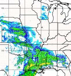
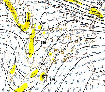
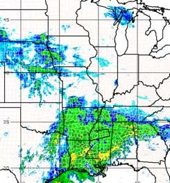
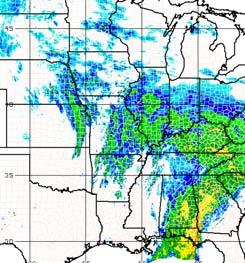
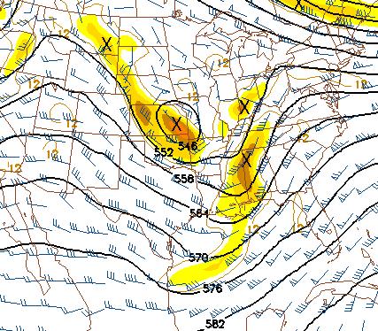
2 0000 UTC 4 Feb 10 Surface P/T/wind 0000 UTC 4 Feb mb Ht/Vort/Wind 0006 UTC 4 Feb 10 radar 0600 UTC 4 Feb 10 Surface P/T/wind 0600 UTC 4 Feb mb Ht/Vort/Wind 0559 UTC 4 Feb 10 radar 1200 UTC 4 Feb 10 Surface P/T/wind 1200 UTC 4 Feb mb Ht/Vort/Wind 1205 UTC 4 Feb 10 radar 1800 UTC 4 Feb 10 Surface P/T/wind 1800 UTC 4 Feb mb Ht/Vort/Wind 1758 UTC 4 Feb 10 radar Figure 1: Evolution of the IOP-17 storm at the surface, 500 mb, and radar echoes from 0000 UTC 4 Feb 10 through 1800 UTC 4 Feb 10. 2


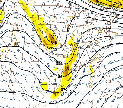
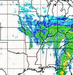
3 0000 UTC 5 Feb 10 Surface P/T/wind 0000 UTC 5 Feb mb Ht/Vort/Wind 0006 UTC 5 Feb 10 radar 0600 UTC 5 Feb 10 Surface P/T/wind 0600 UTC 5 Feb mb Ht/Vort/Wind 0559 UTC 5 Feb 10 radar 1200 UTC 5 Feb 10 Surface P/T/wind 1200 UTC 5 Feb mb Ht/Vort/Wind 1158 UTC 5 Feb 10 radar 1200 UTC 5 Feb 10 Surface P/T/wind 1200 UTC 5 Feb mb Ht/Vort/Wind 1158 UTC 5 Feb 10 radar Figure 2: Evolution of the IOP-17 storm at the surface, 500 mb, and radar echoes from 0000 UTC 5 Feb 10 through 1800 UTC 5 Feb 10. 3


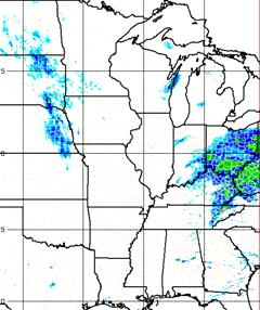
4 0000 UTC 6 Feb 10 Surface P/T/wind 0000 UTC 6 Feb mb Ht/Vort/Wind 0005 UTC 6 Feb 10 radar 0600 UTC 6 Feb 10 Surface P/T/wind 0600 UTC 6 Feb mb Ht/Vort/Wind 0607 UTC 6 Feb 10 radar 1200 UTC 6 Feb 10 Surface P/T/wind 1200 UTC 6 Feb mb Ht/Vort/Wind 1206 UTC 6 Feb 10 radar Figure 3: Evolution of the IOP-17 storm at the surface, 500 mb, and radar echoes from 0000 UTC 6 Feb 10 through 1200 UTC 6 Feb 10. 4


5 3. Precipitation over research area Fig. 4: 24 Hour precipitation ending at 1200 UTC 02/05/10, 1200 UTC 02/06/10, and 1200 UTC 02/07/2010 over the United States 5


6 Fig. 5: 24 Hour precipitation ending at 1200 UTC 02/05/10, and 1200 UTC 02/06/10 over Indiana. 6

7 Fig. 6: one day and storm total snowfall in Indiana for the IOP-17 cyclone Storm total snowfall reported by news organization These totals are preliminary. Indianapolis got six inches by Saturday morning. On Friday, 5.3 inches fell in Indianapolis, breaking a 1908 record of 3.6 inches for that day. Alexandria: 8.5 Atlanta: 7 Avon: 5.8 Bedford: 2 Brownsburg: 6 Columbus: 3.5 Crawfordsville: 4 Economy: 12 Fishers: 6 Fountain City: 9 Frankfort: 8 Franklin: 6.5 Indianapolis: 6 Jamestown: 5.5 Kokomo: 4 Lafayette: 5 Marion: 6 Muncie: 9.5 New Whiteland: 8.5 Noblesville: 7 Portland: 5 Rushville: 6.5 Seymour: 6 Spencer: 4 Parts of Wayne County: 10 7
8 Snowfall reports received at NWS in Indianapolis: SNOW REPORTS LISTED BY AMOUNT INCHES LOCATION ST COUNTY TIME N MUNCIE IN DELAWARE 0225 AM 9.00 RUSHVILLE IN RUSH 0730 AM SSE RIDGEVILLE IN RANDOLPH 0700 AM 8.50 NEW WHITELAND IN JOHNSON 0708 AM S ALEXANDRIA IN MADISON 1125 PM 8.40 MCCORDSVILLE IN HANCOCK 0826 AM 8.00 STRAUGHN IN HENRY 1029 PM S INDIANAPOLIS IN MARION 0800 AM 7.00 NOBLESVILLE IN HAMILTON 0746 AM N INDIANAPOLIS IN MARION 0700 AM WNW ATLANTA IN TIPTON 0530 AM SE CRAWFORDSVILLE IN MONTGOMERY 0700 AM N ZIONSVILLE IN BOONE 0800 AM 6.50 MORRISTOWN IN SHELBY 0700 AM SSW SPEEDWAY IN MARION 0700 AM 6.00 SEYMOUR IN JACKSON 0715 AM SSE NEW CASTLE IN HENRY 0700 AM SW NEW CASTLE IN HENRY 0700 AM 6.00 FRANKFORT IN CLINTON 1003 PM NNW AVON IN HENDRICKS 0700 AM WSW COLUMBUS IN BARTHOLOMEW 0700 AM 5.00 LAFAYETTE IN TIPPECANOE 1003 PM S LAFAYETTE IN TIPPECANOE 0700 AM ENE BROOKLYN IN MORGAN 0820 AM NE NORTH VERNON IN JENNINGS 0730 AM WNW BLOOMINGTON IN MONROE 0800 AM WNW PERRYSVILLE IN VERMILLION 0900 AM SW REELSVILLE IN PUTNAM 0800 AM 4.00 SPENCER IN BROWN 0700 AM WNW COVINGTON IN FOUNTAIN 0700 AM SW KOKOMO IN HOWARD 0515 AM 3.40 WILLIAMS IN LAWRENCE 0700 AM 3.00 FREELANDVILLE IN KNOX 0700 AM 3.00 FLORA IN CARROLL 0700 AM 2.70 MARSHALL IN PARKE 0700 AM SW PENCE IN WARREN 0905 AM S SHOALS IN MARTIN 0700 AM WNW GRAYSVILLE IN SULLIVAN 0700 AM 1.70 TERRE HAUTE IN VIGO 0920 AM 8
9 4. Flight Summary Flight RF-09 focused on the cloud shield north of the weak low pressure center over the Southeast United States. This cloud shield was best characterized as warm frontal rather than the wrap around region of a well developed low. The warm front was evident across the Gulf Coast states. Forcing for this shield of precipitation was weak, and the clouds appeared mostly stratiform on the WCR during the flight. Because of the icing experienced in the previous storm, we took a more cautious approach to the flight track, orienting the flight legs parallel, rather than normal, to the developing dry slot over the Gulf. This essentially made the legs parallel rather than perpendicular to reflectivity enhancements that might be bands. Later in the flight we did run perpendicular legs, but not as far as the dry slot. Because of the warm temperatures in this storm, we were unable to descend very far to obtain microphysical profiles. The flight legs were limited to higher elevations. 9


10 C-130 Flight RF-07 Flight track 1417 UTC 1458 UTC 1530 UTC 1559 UTC 1629 UTC 1659 UTC 1729 UTC 1758 UTC 1830 UTC Figure 7: C-130 flight track overlaid on radar composites from 1400 UTC 4 Feb 10 through 1830 UTC 4 Feb 10. Times shown are the times of the radar composites. The flight track for the period just before the composite is shown. 10


11 1857 UTC 1930 UTC 1958 UTC 2031 UTC 2058 UTC 2119 UTC Figure 8: C-130 flight track overlaid on radar composites from 1900 UTC 4 Feb 10 through 2130 UTC 4 Feb 10. Times shown are the times of the radar composites. The flight track for the period just before the composite is shown. 11


12 1345 UTC to 1408 UTC 1408 UTC to 1431 UTC 1431 UTC to 1454 UTC 1454 UTC to 1516 UTC 1516 UTC to 1519 UTC 1519 UTC to 1541 UTC Fig. 9: Wyoming Cloud Radar Quicklook of radar reflectivity between 1345 UTC 4 Feb 10 and 1541 UTC 4 Feb

13 1541 UTC to 1603 UTC 1603 UTC to 1625 UTC 1625 UTC to 1647 UTC 1647 UTC to 1709 UTC 1710 UTC to 1732 UTC 1732 UTC to 1754 UTC Fig. 10: Wyoming Cloud Radar Quicklook of radar reflectivity between 1541 UTC 4 Feb 10 and 1754 UTC 4 Feb
14 1754 UTC to 1816 UTC 1816 UTC to 1839 UTC 1839 UTC to 1901 UTC 1901 UTC to 1923 UTC 1923 UTC to 1946 UTC 1946 UTC to 2008 UTC Fig. 11: Wyoming Cloud Radar Quicklook of radar reflectivity between 1754 UTC 4 Feb 10 and 2008 UTC 4 Feb


15 2008 UTC to 2031 UTC 2031 UTC to 2053 UTC 2053 UTC to 2115 UTC Fig. 12: Wyoming Cloud Radar Quicklook of radar reflectivity between 2008 UTC 4 Feb 10 and 2115 UTC 4 Feb

16 5. MIPS operations: The MIPS was located in Martinsville, which is in the White River Valley. As a result of the low elevation relative to the plains above the valley, the precipitation at the MIPS site, because of melting, was wetter and the total snowfall much less. A local minimum of 2 inches of slush was on the ground at the end of the IOP. The heavy wet snow led to significant attenuation problems for the XPR as it accumulated on the top surface of the radar. The radar had to be swept often to keep up the signal strength. All other instruments operated without any problems. Fig. 13: Example of 90 sec. segment of XPR radar reflectivity showing two distinct layers 16


17 Figure 14: MIPS 915 MHz Profiler SNR, vertical velocity and spectral width for the period of operation 0300 UTC 5 Feb 10 through 0000 UTC 6 Feb 10 17


18 Figure 15: MIPS 915 MHz Profiler SNR, vertical velocity and spectral width for the period of operation 0000 UTC 6 Feb 10 through 1200 UTC 6 Feb 10 18


19 6. MAX operations: The MAX was located on the plains above the river valley and experienced similar snowfall amounts to those characterized by the local observations on the figures and tables in Sec. 3. The MAX operated without any problems. MAX RHI Reflectivity showing bands at 1454 UTC MAX RHI Reflectivity showing bands at 1538 UTC MAX Correlation coefficient showing bands at 1454 UTC MAX Correlation coefficient showing bands at 1538 UTC Fig. 16: MAX Radar RHIs of radar reflectivity and the Correlation Coefficient at 1454 and 1538 UTC 5 Feb

20 7. MISS 915 MHz Profiler The MISS operated MISS at the Super-8 Hotel, Franklin, IN. No problems occurred during operations. Figure 17: MISS 915 MHz Profiler SNR, vertical velocity and spectral width for the period of operation 0000 UTC 5 Feb 10 through 0000 UTC 6 Feb 10 20

21 Figure 18: MISS 915 MHz Profiler SNR and Winds or the period of operation 0000 UTC 5 Feb 10 through 0000 UTC 6 Feb 10 21

22 Figure 19: MISS 915 MHz Profiler SNR, vertical velocity and spectral width for the period of operation 0000 UTC Feb 10 through 1700 UTC 6 Feb 10 22

23 Figure 20: MISS 915 MHz Profiler SNR and Winds or the period of operation 0000 UTC 6 Feb 10 through 1400 UTC 6 Feb 10 23
24 8. Rawinsondes Rawinsondes were launched at the MISS site in Franklin, IL on a 3 hourly schedule. The following soundings were launched DATE Launch Nominal Date and time Status UTC UTC Good UTC UTC Good UTC UTC Good UTC UTC Failed UTC UTC Good UTC UTC Good UTC UTC Good UTC UTC Good UTC UTC Good Rawinsondes were launched not launched by Missouri during this IOP because of an equipment failure. 24

25 MISS Sounding 0600 UTC 05 Feb 10 MISS Sounding 0900 UTC 05 Feb 10 MISS Sounding 1200 UTC 05 Feb 10 MISS Sounding 1800 UTC 05 Feb 10 25

26 MISS Sounding 2100 UTC 05 Feb 10 MISS Sounding 0000 UTC 06 Feb 10 MISS Sounding 0300 UTC 05 Feb 10 MISS Sounding 0600 UTC 06 Feb 10 26
IC Chapter 6. County Corrections Fund. IC Repealed (Repealed by P.L , SEC.11.)
") IC 11-12-6 Chapter 6. County Corrections Fund IC 11-12-6-1 IC 11-12-6-2 "County misdemeanant fund" defined Sec. 2. As used in this chapter, "county misdemeanant fund" refers to a fund established under
IC 11-12-6 Chapter 6. County Corrections Fund IC 11-12-6-1 IC 11-12-6-2 "County misdemeanant fund" defined Sec. 2. As used in this chapter, "county misdemeanant fund" refers to a fund established under
Adams County 1145 Bollman St. P.O. Box 227 Decatur, IN Cass County 1714 Dividend Drive Logansport, IN
 everybodycounts.org Division of Family Resources 1. Adams County 1145 Bollman St. P.O. Box 227 Decatur, IN 46733 260-724-9169 Allen Co. County 201 E. Rudisill Blvd., Suite 100 Fort Wayne, IN 46806 260-458-6200
P2.17 OBSERVATIONS OF STRONG MOUNTAIN WAVES IN THE LEE OF THE MEDICINE BOW MOUNTAINS OF SOUTHEAST WYOMING
 P2.17 OBSERVATIONS OF STRONG MOUNTAIN WAVES IN THE LEE OF THE MEDICINE BOW MOUNTAINS OF SOUTHEAST WYOMING Larry D. Oolman 1, Jeffrey R. French 1, Samuel Haimov 1, David Leon 1, and Vanda Grubišić 2 1 University
AGM 2015 Club Vote Count
 CLUB # District CLUB NAME Fall DISTRICT 1 109 1 CROWN POINT SOCCER CLUB 0 0 0 0 inactive - no registrations 114 1 VALPO SOCCER CLUB 26 5 31 1 125 1 INDIANA ELITE FC 156 92 248 1 131 1 FC REVOLUTION 61
07/23/02 FC: All aircraft suppressed day hoping for late take-off
 07/23/02 FC: Report: Summary: Aircraft: All aircraft suppressed day hoping for late take-off The forecast called for redeveloping maritime convection NE of Florida, with cloud tops getting to 12 to 14
September 23, champion, will host Martinsville in Sectional 24. Thirdranked
 September 23, 2016 Pairings Announced for Boys & Girls Soccer State Tournaments A record number of teams were paired this morning for the 23rd Annual IHSAA Boys and Girls Soccer State Tournaments which
State tournament brackets, including dates and times and results for each match, will be uploaded to IHSAA.org this week. September 25, 2017.
 September 25, 2017 Boys Tennis State Tournament Pairings Revealed For the first time, the sectional pairings for the 51 st Annual IHSAA Boys Tennis State Tournament were revealed to an online audience
Advancing Indiana is a consortium o f individuals, organizations and businesses.
 What is Advancing Indiana? Advancing Indiana is a consortium o f individuals, organizations and businesses. Hoosiers who understand that our roads and bridges are deteriorating faster than w e can fix
2016 Club Vote Count
 DISTRICT 1 114 1 VALPO SOCCER CLUB 0 0 0 1 active fall 2015 125 1 INDIANA ELITE FC 163 96 259 2 131 1 FC REVOLUTION 81 33 114 1 132 1 MILLENNIUM SC 120 180 300 2 138 1 THREE LIONS UNITED 328 163 491 2
Jackson, TN MSA 64,810 62,540 2, Johnson City-Kingsport-Bristol, TN-VA CSA 230, ,020 7,
 Labor Force Estimates - United States & Tennessee Release: 1:30 PM CT on 12/27/2018 November, 2018 preliminary Oct. '18 revised Nov. '17 Seasonally Adjusted* Labor Force Employed Unemployed Rate Rate Change
3/8/2016 Oregon Wallowa Mountains Published by Michael Hatch (Wallowa Avalanche Center) and Scott Savage (on behalf of USFS National Avalanche Center)
 and Scott Savage (on behalf of USFS National Avalanche Center)") Location: Place Chief Joseph Peak, Wallowa Mountains State Oregon Date 3/8/2016 Time 1630 hrs Summary 1 skier partially buried and killed Number: Caught 1 Fully Buried 0 Injured 0 Killed 1 Avalanche Details:
Location: Place Chief Joseph Peak, Wallowa Mountains State Oregon Date 3/8/2016 Time 1630 hrs Summary 1 skier partially buried and killed Number: Caught 1 Fully Buried 0 Injured 0 Killed 1 Avalanche Details:
Design Criteria Data
 FRESNO CA Latitude = 36.77 N WMO No. 72389 Longitude =119.7 W Elevation = 328 feet Period of Record = 1972 to 1996 Average Pressure = 29.62 inches Hg Design Criteria Data Mean Coincident (Average) Values
Design Criteria Data
 MEMPHIS TN Latitude = 35.35 N WMO No. 723345 Longitude = 89.87 W Elevation = 322 feet Period of Record = 1973 to 1996 Average Pressure = 29.68 inches Hg Design Criteria Data Mean Coincident (Average) Values
Population Change during Trying Times: Illinois New Demographic Reality
 Change during Trying Times: Illinois New Demographic Reality Dr. Matthew Hall IGPA Faculty Member Assistant Professor of Sociology, University of Illinois at Chicago Highlights 1. Illinois grew by 411,399
IHSAA Football State Tournament Begins October 19 Post season anticipation began tonight as 319 teams received notice of their sectional opponents
 October 7, 2018 IHSAA Football State Tournament Begins October 19 Post season anticipation began tonight as 319 teams received notice of their sectional opponents via live webstream at IHSAAtv.org and
Design Criteria Data
 TUCUMCARI NM Latitude = 35.18 N WMO No. 723676 Longitude =13.6 W Elevation = 465 feet Period of Record = 1973 to 1996 Average Pressure = 25.86 inches Hg Design Criteria Data Mean Coincident (Average) Values
NordFoU: External Influences on Spray Patterns (EPAS) Report 16: Wind exposure on the test road at Bygholm
 Report 16: Wind exposure on the test road at Bygholm") NordFoU: External Influences on Spray Patterns (EPAS) Report 16: Wind exposure on the test road at Bygholm Jan S. Strøm, Aarhus University, Dept. of Engineering, Engineering Center Bygholm, Horsens Torben
NordFoU: External Influences on Spray Patterns (EPAS) Report 16: Wind exposure on the test road at Bygholm Jan S. Strøm, Aarhus University, Dept. of Engineering, Engineering Center Bygholm, Horsens Torben
State Tournament Pairings Announced for Boys Basketball Indiana Pacers, Indiana Fever Are Presenting Sponsors of State Tournament
 February 17, 2019 State Tournament Pairings Announced for Boys Basketball Indiana Pacers, Indiana Fever Are Presenting Sponsors of State Tournament Four hundred (400) teams were drawn today and placed
A total of 395 schools and 5,318 student athletes are set to participate in the tourney which begins next week.
 January 25, 2016 Stage Set for 2016 IHSAA Girls Basketball State Tournament From the playing floor at Bankers Life Fieldhouse in Indianapolis, the opening week s pairings were made this evening for the
DANGEROUS DRIVING 2008
 May 2009 A collision produces three levels of data: collision, unit (vehicles), and individual. For this reason, readers should pay particular attention to the wording of statements about the data to avoid
COMPARISON OF CONTEMPORANEOUS WAVE MEASUREMENTS WITH A SAAB WAVERADAR REX AND A DATAWELL DIRECTIONAL WAVERIDER BUOY
 COMPARISON OF CONTEMPORANEOUS WAVE MEASUREMENTS WITH A SAAB WAVERADAR REX AND A DATAWELL DIRECTIONAL WAVERIDER BUOY Scott Noreika, Mark Beardsley, Lulu Lodder, Sarah Brown and David Duncalf rpsmetocean.com
Renewals Complete as of 1/23/2018 9:14 AM
 CAROLINA CORVETTES CA-014 12/7/17 CORVETTE CHARLESTON CA-161 12/2/17 CORVETTES INTERNATIONAL CA-174 12/7/17 SPARTANBURG CORVETTE CLUB CA-177 12/7/17 CHEVY S UNDER GLASS CA-203 12/2/17 FREE WHEELING CORVETTE
Course 1 (18.0 NM) From the start,
 From the start,") CORINTHIAN YACHT CLUB OF PHILADELPHIA 2016 Fall Cruise RACE COURSES Start 10:45 Friday, September 16th, 2016 The start will be in the Tred Avon River off the Tred Avon Yacht Club between the Race Committee
CORINTHIAN YACHT CLUB OF PHILADELPHIA 2016 Fall Cruise RACE COURSES Start 10:45 Friday, September 16th, 2016 The start will be in the Tred Avon River off the Tred Avon Yacht Club between the Race Committee
FY ' 06 Apiary Inspection Report Illinois Department of Agriculture (July 1, 2005 through June 30, 2006)
") FY ' 06 Apiary Inspection Report Illinois Department of Agriculture (July 1, 2005 through June 30, 2006) The Apiary Inspection Section of the Illinois Department of Agriculture administers the Illinois
FY ' 06 Apiary Inspection Report Illinois Department of Agriculture (July 1, 2005 through June 30, 2006) The Apiary Inspection Section of the Illinois Department of Agriculture administers the Illinois
2018 Men's State Basketball Tournament
 DATE: March 24, 2018 CATEGORY: Unified DIVISION: Brown Marion Co. West Heat 42 Day: Saturday, March 17th Time: 9:00am Marion Co. West Heat Marion Co. West Celtics 10 Time: 2:15pm Marion Co. West Bulldogs
FY ' 04 Apiary Inspection Report Illinois Department of Agriculture (July 1, 2003 through June 30, 2004)
") FY ' 04 Apiary Inspection Report Illinois Department Agriculture (July 1, 2003 through June 30, 2004) The Apiary Inspection Section the Illinois Department Agriculture administers the Illinois Bees and
FY ' 04 Apiary Inspection Report Illinois Department Agriculture (July 1, 2003 through June 30, 2004) The Apiary Inspection Section the Illinois Department Agriculture administers the Illinois Bees and
Labor Force Estimates - United States & Tennessee. Labor Force Estimates - Combined Statistical Areas (CSA)
") Labor Force Estimates - United States & Tennessee Seasonally Adjusted* UNITED STATES 153,716,000 142,099,000 11,616,000 7.6% 7.2% 0.4% 4.9% 2.7% TENNESSEE 3,035,200 2,773,400 261,800 8.6% 7.6% 1.0% 5.3%
Labor Force Estimates - United States & Tennessee Seasonally Adjusted* UNITED STATES 153,716,000 142,099,000 11,616,000 7.6% 7.2% 0.4% 4.9% 2.7% TENNESSEE 3,035,200 2,773,400 261,800 8.6% 7.6% 1.0% 5.3%
Americans with Disabilities Act Indiana Transition Plan. Louis E. Feagans Jr. PE Statewide Technical Service Director, Indiana DOT
 Americans with Disabilities Act Indiana Transition Plan Louis E. Feagans Jr. PE Statewide Technical Service Director, Indiana DOT Accomplishments (2015-16) ADA Program Manager Completion of the self inventory
Pasture Cash Rental Rates
 $/acre Pasture Cash Rental Rates One of the most common questions fielded by Extension pertains to rental rates. In Illinois, pasture land can be variable not just county to county, but also farm to farm.
HOW UNINSURED RATES IN TENNESSEE COUNTIES VARY BY EMPLOYMENT AND INCOME
 HOW UNINSURED RATES IN TENNESSEE COUNTIES VARY BY EMPLOYMENT AND INCOME Some Tennesseans are more likely to have health insurance than others. Age, income, education, and race/ethnicity are a just few
105 th IHSAA Boys Basketball State Tournament Pairings Announced Indiana Pacers, Indiana Fever Are Presenting Sponsors of State Tournament
 February 22, 2015 105 th IHSAA Boys Basketball State Tournament Pairings Announced Indiana Pacers, Indiana Fever Are Presenting Sponsors of State Tournament Three hundred ninety seven (397) teams were
Hall of Fame Inductees and Members. Indiana High School Golf Coaches Association
 Hall of Fame Inductees and Members Indiana High School Golf Coaches Association Name School/Affiliation Inductee Category Year Fred Keesling Lawrence School Corporation Official 1979 Dale Morey Martinsville
WEATHER SYSTEMS OF MIDDLE LATITUDES
 CHAPTER 10 WEATHER SYSTEMS OF MIDDLE LATITUDES MULTIPLE CHOICE QUESTIONS 1. In equal volumes, which one of the following air masses exerts the highest surface air pressure? a. cp *b. A c. mp d. ct e. mt
Characterization of Boundary-Layer Meteorology During DISCOVER-AQ
 Characterization of Boundary-Layer Meteorology During DISCOVER-AQ Daniel M. Alrick and Clinton P. MacDonald Sonoma Technology, Inc. Gary A. Morris St. Edward s University for Texas Air Quality Research
It seemed that airplanes arriving and departing AVWEATHER
 BY ED BROTAK It seemed that airplanes arriving and departing from Will Rogers World Airport in Oklahoma City, Oklahoma, United States, on the morning of Aug. 3, 2012, would have few problems with wind
Mesoscale Meteorology
 Mesoscale Meteorology METR 4433 Spring 2015 3.4 Drylines The dryline is a mesoscale phenomena whose development and evaluation is strongly linked to the PBL. In this section, we will consider its general
The Influence of the Chesapeake Bay Breeze on Maryland Air Quality
 The Influence of the Chesapeake Bay Breeze on Maryland Air Quality MARAMA Data Analysis Workshop Laura Landry January 20, 2011 Martin O Malley, Governor Anthony G. Brown, Lt. Governor Robert M. Summers,
2011 Final Point Standings ~ Clubs
 2011 Final Point Standings ~ Clubs PLACE CLUB NAME 1 CORNHUSKER CORVETTE CLUB WR-095 27968 7 2 OKLAHOMA CITY CORVETTE CLUB SW-131 13718 7 3 MICHIGAN AUTOCROSS GROUP MI-362 13010 7 4 CORVETTE CLUB OF MICHIGAN
Host schools will announce playing schedules in the days to come which will then be added to the online brackets at MaxPreps.com.
 April 29, 2018 Another Record Number of Schools Entered in Softball Tournament For the second consecutive year, a record number of teams (379) one better than 2017 were drawn and placed into brackets this
2017 Men's State Basketball Tournament
 DATES: March 25, 2017 DIVISION: UMM Brown Marion Co. West Jazz 20 Time: 12:30pm Putnam Co. Trailblazers 32 Putnam Co. Trailblazers 50 Time: 3:30pm Putnam Co. Trailblazers Marion Co. East WC Gold 28 CATEGORY:
NATIONAL COUNCIL of CORVETTE CLUBS, INC. MEMBERSHIP REPORT for FEB. 27, 2015
 NATIONAL COUNCIL of CORVETTE CLUBS, INC. MEMBERSHIP REPORT for FEB. 27, 2015 REGION CLUBS MEMBERS MALs FCOA LARGEST CLUB IN THE REGION MEMBERS Carolina Region 10 249 20 23 CAROLINA CORVETTES 73 East Ohio
Climate of Colorado. Climatography of the United States No. 60 (updated 1/2003) Prepared by
 Prepared by") Climate of Colorado Climatography of the United States No. 60 (updated 1/2003) Prepared by Nolan J. Doesken, Roger A. Pielke, Sr., and Odilia A.P. Bliss Colorado Climate Center, Atmospheric Science Department,
Climate of Colorado Climatography of the United States No. 60 (updated 1/2003) Prepared by Nolan J. Doesken, Roger A. Pielke, Sr., and Odilia A.P. Bliss Colorado Climate Center, Atmospheric Science Department,
Oceans and the Global Environment: Lec 2 taking physics and chemistry outdoors. the flowing, waving ocean
 Oceans and the Global Environment: Lec 2 taking physics and chemistry outdoors the flowing, waving ocean Peter Rhines 1 Eric Lindahl 2 Bob Koon 2, Julie Wright 3 www.ocean.washington.edu/courses/has221a-08
Fighting Alabama s Prescription Drug Abuse Epidemic
 Fighting Alabama s Prescription Drug Abuse Epidemic Lori M. Quiller, APR Director, Communications & Social Media Medical Association of the State of Alabama Alabama Statistics How bad is prescription drug
Local Chapter Pictorial
 APA Local Chapter Pictorial Local Chapter Pictorial Alamo Chapter of the APA Albuquerque Chapter APA of Acadiana Atlanta Chapter Birmingham Payroll Association Buffalo-Niagara Chapter Cascade Payroll Association
Summertime precipitation patterns associated with the sea breeze and land breeze in southern Mississippi and eastern Louisiana
 Summertime precipitation patterns associated with the sea breeze and land breeze in southern Mississippi and eastern Louisiana Patrick J. Fitzpatrick Christopher M. Hill James H. Corbin Yee H. Lau Sachin
Hoosier Lottery Retailer Terminal Promotion
 Hoosier Lottery Retailer Terminal Promotion WHAT: Receive one (1) FREE $1 Daily 3 Straight Wager ticket. HOW: By making a purchase of one (1) $5 HOOSIER JACKPOT! Fast Play ticket. Tickets must be purchased
COMPARISON OF CONTEMPORANEOUS WAVE MEASUREMENTS WITH A SAAB WAVERADAR REX AND A DATAWELL DIRECTIONAL WAVERIDER BUOY
 31 Bishop Street, Jolimont Western Australia 6014 T +61 8 9387 7955 F +61 8 9387 6686 E info@rpsmetocean.com W rpsmetocean.com & rpsgroup.com.au COMPARISON OF CONTEMPORANEOUS WAVE MEASUREMENTS WITH A SAAB
The Top 60 Senior Workout includes the state s top two leading scorers Dana Evans, Gary West (36 ppg) and Macee Williams, Fountain Central (26.2).
 and Macee Williams, Fountain Central (26.2).") Eight players who will participate in the 2017 IHSAA State Finals highlight the list of the Top 60 invitees Jazmyne Geist, Karissa McLaughlin and Madisen Parker (AAAA - Homestead), Nicole Konieczny and
Eight players who will participate in the 2017 IHSAA State Finals highlight the list of the Top 60 invitees Jazmyne Geist, Karissa McLaughlin and Madisen Parker (AAAA - Homestead), Nicole Konieczny and
What Causes Different Weather?
 What Causes Different Weather? Table of Contents What causes weather?...3 What causes it to rain or snow?...4 What causes flooding?...5 What causes hail?...6 What causes the seasons?...7-8 What causes
Chart Discussion: Fri-25-May-2018 Rainfall Last Week
 Chart Discussion: Fri-25-May-2018 Rainfall Last Week 1 Last Week s Charts 2 MSL Analysis / Sat Image (Thu) 3 MSL Analysis / Sat Image (Fri) 4 Last Week s Model Forecasts OBSERVED Chart Discussion: Fri-25-May-2018
Kentucky - Title 1 Grants To Educational Agencies
 LEA ID District 2100030 ADAIR COUNTY SCHOOL 2100070 ALLEN COUNTY SCHOOL 2100090 ANCHORAGE INDEPENDENT SCHOOL 2100120 ANDERSON COUNTY SCHOOL 2100150 ASHLAND INDEPENDENT SCHOOL 2100180 AUGUSTA INDEPENDENT
2.4. Applications of Boundary Layer Meteorology
 2.4. Applications of Boundary Layer Meteorology 2.4.1. Temporal Evolution & Prediction of the PBL Earlier, we saw the following figure showing the diurnal evolution of PBL. With a typical diurnal cycle,
Global Weather Patterns
 Global Weather Patterns AZ State Standards Concept 2: Energy in the Earth System (Both Internal and External) Understand the relationships between the Earth s land masses, oceans, and atmosphere. PO 2.
Abrupt marine boundary layer changes revealed by airborne in situ and lidar measurements
 Abrupt marine boundary layer changes revealed by airborne in situ and lidar measurements David A. Rahn 1, Thomas R. Parish 2, and David Leon 2 1 Univeristy of Kansas 2 Univeristy of Wyoming Precision Atmospheric
El Niño and the Winter Weather Outlook
 El Niño and the 2015-2016 Winter Weather Outlook 2015 NASEO Annual Meeting http://www.ospo.noaa.gov/products/ocean/sst/anomaly/ NWS Boston February 10, 2015 Jimmy Taeger Meteorologist National Weather
TENNESSEE OFFICE OF LOCAL GOVERNMENT County Property Assessment Maps, Record Group 337
 State of Tennessee Department of State Tennessee State Library and Archives TENNESSEE OFFICE OF LOCAL GOVERNMENT County Property Assessment Maps, 1973-1984 Record Group 337 COLLECTION SUMMARY Creator:
ILLINO PRODUCTION NOTE. University of Illinois at Urbana-Champaign Library Large-scale Digitization Project, 2007.
 ILLINO S UNIVERSITY OF ILLINOIS AT URBANA-CHAMPAIGN PRODUCTION NOTE University of Illinois at Urbana-Champaign Library Large-scale Digitization Project,. ADMINISTRATIVE REPORT HUNTER ACTIVITY AND WILDLIFE
ILLINOIS INCLUDED IN METROPOLITAN STATISTICAL AREA Cape Girardeau-Jackson, MO-IL MSA St. Louis, MO-IL MSA Rockford, IL MSA
 2012 2013 ARTS MIDWEST TOURING FUND METROPOLITAN STATISTICAL AREA (MSA) DETERMINATIONS BY COUNTY For counties in Illinois, Indiana, Iowa, Michigan, Minnesota, North Dakota, Ohio, South Dakota, and Wisconsin
K.H.S. GIRLS BASKETBALL
 SINGLE GAME TEAM RECORDS CATEGORY RECORD OPPONENT YEAR POINTS SCORED IN A GAME 114 vs. Tipton 1992-93 POINTS SCORED IN A HALF 71 vs.tipton 1992-93 POINTS SCORED IN A QUARTER 46 vs. Tipton 1992-93 WINNING
14.1 PRECIPITATION SHADOWS IN THE HUDSON VALLEY
 14.1 PRECIPITATION SHADOWS IN THE HUDSON VALLEY Jeffrey M. Freedman* Atmospheric Information Services, Albany, NY David R. Fitzjarrald, Ricardo K. Sakai, and Mathew J. Czikowsky Atmospheric Sciences Research
THE ATMOSPHERE. WEATHER and CLIMATE. The Atmosphere 10/12/2018 R E M I N D E R S. PART II: People and their. weather. climate?
 R E M I N D E R S Two required essays are due by Oct. 30, 2018. (A third may be used for extra credit in place of a Think Geographically essay.) ESSAY TOPICS (choose any two): Contributions of a noted
The General Circulation and El Niño. Dr. Christopher M. Godfrey University of North Carolina at Asheville
 The General Circulation and El Niño Dr. Christopher M. Godfrey University of North Carolina at Asheville Global Circulation Model Air flow broken up into 3 cells Easterlies in the tropics (trade winds)
Kodiak, Alaska Site 1 Wind Resource Report
 Kodiak, Alaska Site 1 Wind Resource Report Report written by: Douglas Vaught, P.E., V3 Energy LLC, Eagle River, AK Date of report: March 16, 2007 Photo by Doug Vaught, V3 Energy LLC Summary Information
Work Destination Report - Where Workers are Employed Who Live in the Selection Area - by Counties
 Boyle y Kentucky: All ies Work Destination Report - Where Workers are Employed Who Live in the Selection Area - by ies Total All Jobs Total All Jobs 11,326 100.0% Jobs s by ies Where Boyle y, KY 4,826
Lecture 13 March 24, 2010, Wednesday. Atmospheric Pressure & Wind: Part 4
 Lecture 13 March 24, 2010, Wednesday Atmospheric Pressure & Wind: Part 4 Synoptic scale winds Mesoscale winds Microscale winds Air-sea interactions The largest synoptic scale wind. Monsoon: Arabic for
Background Preliminary Review... 3
 January 23, 2012 Evaluation of Prop osed NRWC Wind Farm on Lo cal Micro climate: Preliminary Review & Work Plan For: Debbie Zimmerman Chief Executive Officer Grap e Growers of Ontario P.O. Box 100 Vineland
The dryline is a mesoscale phenomena whose development and evaluation is strongly linked to the PBL.
 2.2. Development and Evolution of Drylines The dryline is a mesoscale phenomena whose development and evaluation is strongly linked to the PBL. Text books containing sections on dryline: The Dry Line.
Monsoon. Arabic word mausim means season. Loose definition: a wind/precipitation pattern that shifts seasonally
 Monsoon Arabic word mausim means season Loose definition: a wind/precipitation pattern that shifts seasonally Classical criteria (Ramage 1971) Prevailing wind shifts 120 o between Jan & July Average frequency
Chart Discussion: Fri-15-Jun-2018 Rainfall Last Week
 Chart Discussion: Fri-15-Jun-2018 Rainfall Last Week 1 Last Week s Charts 2 Last Week s Melbourne Wind Forecasts Forecast 3 PM WIND for 1,2,3,4,5,6,7,8,9,10 Days Ahead [ACCESS model] 1- Jun- 18 SSE SSE
HANDICAP ACTIVE AND INACTIVE SEASON SCHEDULE
 HANDICAP ACTIVE AND INACTIVE SEASON SCHEDULE The authorized golf association having jurisdiction in an area is responsible for declaring the duration of any inactive season. Any non-member club of an authorized
WIND IN KNOTS, WAVE HEIGHTS IN METERS. NO SEA STATE GIVEN IF WAVES LESS THAN 3M.
 DATE ISSUED: 14/08/2015 FORECAST VALID FROM 132200 TO 142200 UTC: IN KNOTS, WAVE HEIGHTS IN METERS. NO SEA STATE GIVEN IF WAVES LESS THAN 3M. GALE WARNINGS: ============== 1 / 13 1. TRISTAN: SW 35 in the
Drought and the Climate of the Ogallala Aquifer
 Drought and the Climate of the Ogallala Aquifer Nolan J. Doesken Colorado Climate Center Colorado State University Presented at Ogallala Symposium, Wray, Colorado February 20, 2006 Prepared by Odie Bliss
National Weather Service
 National Weather Service The North American Monsoon Until the late 1970s, there was serious debate about whether a monsoon truly existed in North America. However, considerable research, which culminated
Chapter 8 Air Masses
 Chapter 8 Air Masses Air Masses - 1 1. An Air Mass is a large body of air usually about 1500 km across and several km thick, that has homogeneous physical properties. 2. The important physical properties
Currents measurements in the coast of Montevideo, Uruguay
 Currents measurements in the coast of Montevideo, Uruguay M. Fossati, D. Bellón, E. Lorenzo & I. Piedra-Cueva Fluid Mechanics and Environmental Engineering Institute (IMFIA), School of Engineering, Research
Gravity waves and bores. Material kindly provided by Dr. Steven Koch GSD NOAA (Boulder, CO)
") Gravity waves and bores Material kindly provided by Dr. Steven Koch GSD NOAA (Boulder, CO) Presented at Iowa State University 11 April 2005 What is a gravity wave? An oscillation caused by the displacement
Gravity waves and bores Material kindly provided by Dr. Steven Koch GSD NOAA (Boulder, CO) Presented at Iowa State University 11 April 2005 What is a gravity wave? An oscillation caused by the displacement
Equine Equine Income Acres
 Equine Equine Equine of Equine State Equine Income Acres Operations Sold Sold Inventory State Adair 13700 $436,000 420 880 3400 $8,906,000 Allen 9600 $259,000 450 460 2400 $6,611,000 Anderson 6100 180
4-H EXPRESS. Hello Montgomery County 4-H Families!! The January edition of the 4-H Express newsletter is full of information but the most important is
 4-H EXPRESS Hello Montgomery County 4-H Families!! The January edition of the 4-H Express newsletter is full of information but the most important is January 15th is the deadline for 4-H enrollment. Please
Intermountain West Climate Summary
 Intermountain West Climate Summary A product of The Western Water Assessment Issued October 2010 Vol. 6, Issue 6 ENSO and Intermountain West Water Supply: A Review of Water Year 2010 and Outlook for Water
APA Local Chapter Pictorial
 APA Local Chapter Pictorial Alamo Chapter of the APA Albuquerque Chapter APA of Acadiana Atlanta Chapter Broward County Association of Payroll Professionals Buffalo-Niagara Chapter Cascade Payroll Association
Recent Atmospheric and Oceanic Circulation Changes Affecting Winter Weather in North America. Dr. Art Douglas Professor Emeritus Creighton University
 Recent Atmospheric and Oceanic Circulation Changes Affecting Winter Weather in North America Dr. Art Douglas Professor Emeritus Creighton University Outline 1. The 2018 El Nino: A Northern Hemisphere induced
Tennessee Wildlife Resources Commission
 Tennessee Wildlife Resources Commission Proclamation 08-07 Statewide Big Game Hunting Seasons and Bag Limit (Exclusive of Wildlife Management Areas and Refuges) Pursuant to the authority granted by Tennessee
Tennessee Wildlife Resources Commission. Proclamation 07-07
 Tennessee Wildlife Resources Commission Proclamation 07-07 Statewide Big Game Hunting Seasons and Bag Limit (Exclusive of Wildlife Management Areas and Refuges) Pursuant to the authority granted by Tennessee
The atmospheric circulation system
 The atmospheric circulation system Key questions Why does the air move? Are the movements of the winds random across the surface of the Earth, or do they follow regular patterns? What implications do these
Near Miss Avalanche Incident Jan 3 rd, 2014
 Near Miss Avalanche Incident Jan 3 rd, 2014 Location: Turnagain Pass Tincan mountain - Lower CFR, West aspect Summary Tincan avalanche, dog fully buried, presumed dead January 3rd, 2014 2:50pm HS-AO-D2.5-R2.5-O/G
Crown Point Avalanche Incident January 4 th, 2017
 Crown Point Avalanche Incident January 4 th, 2017 Report by Dennis D Amico and Ian Nicholson Incident snapshot Occurrence Time and Date: 1100 am on January 4th, 2017 Location: Crown Point, Pickhandle Basin,
The Diurnal Distribution of Lightning over North Florida and Its Relation to the Prevailing Low-Level Flow
 729 The Diurnal Distribution of Lightning over North Florida and Its Relation to the Prevailing Low-Level Flow JOSEPH P. CAMP Department of Meteorology, The Florida State University, Tallahassee, Florida
All-Time College Football Attendance (Includes all divisions and non-ncaa teams) No. Total P/G Yearly Change No. Total P/G Yearly Change Year Teams
 No. Total P/G Yearly Change No. Total P/G Yearly Change Year Teams") Attendance Records All-Time College Football Attendance... 2 All-Time NCAA Attendance... 2 Annual Conference Attendance Leaders... 4 Largest Regular-Season Crowds... 11 2010 Attendance... 11 Annual Team
Attendance Records All-Time College Football Attendance... 2 All-Time NCAA Attendance... 2 Annual Conference Attendance Leaders... 4 Largest Regular-Season Crowds... 11 2010 Attendance... 11 Annual Team
TABLE C: STATE MANDATES AND FUNDING LEVELS
 TABLE C: STATE MANDATES AND FUNDING LEVELS Information was collected from the 2012-2013 State of the States in Gifted Education report. Empty cells indicate no response to the question Hatched cells indicate
You Can Die Here PRACTICE Regents Exam Questions
 You Can Die Here PRACTICE Regents Exam Questions 1. Which diagram best illustrates how air rising over a mountain produces precipitation? (1) (3) (2) (4) 2. As a parcel of air rises, its temperature will
Men's 60m Dash. Finals: Preliminaries: Heat #1. Preliminaries: Heat #2. Preliminaries: Heat #3
 Men's 60m Dash Finals: 1 1 Johnson, Matthew SR Lafayette Jefferson 2 2 Dotson, Malcolm JR Indianapolis Cathed 3 3 Jessup, Marcus SR Lawrence Central 4 4 Harris, J- Shun SR Fishers 5 5 Honaker, Wess JR
Bald Eagle Ridge. Bald Eagle Ridge. How to Get There. The World s Longest Diamond Mine. The World s Longest Diamond Mine. From Toronto.
 Bald Eagle Ridge The World s Longest Diamond Mine Bald Eagle Ridge The World s Longest Diamond Mine 320 320 o 350 o Williamsport, North End How to Get There 335 o 295 o 800 800 km Altoona Ridge Soaring
Arizona Climate Summary December 2008
 Arizona Climate Summary December 28 Summary of conditions for November 28 November 28 Temperature and Precipitation Summary November 1 st - 11 th : November began with high pressure over the western U.S.,
Nolan Doesken. Colorado Climate Center.
 Nolan Doesken Colorado Climate Center Presented to: Colorado Conservation Tillage Association, Greeley, CO, February 1-2, 1 2005 http://ccc.atmos.colostate.edu Prepared by Odie Bliss 1 Key Features of
Directions to BCHS Opponents Events
 Directions to BCHS Opponents Events Austin High School: (401 South Highway 31, Austin) Hwy 39 to 256 east. Continue on 256 E to US 31. Turn south (right) on US 31. School is on the left. Batesville High
SPECIFIED EXPUNGEMENT DOCUMENTS FILED 7/15/ /16/2016 STATEWIDE
 The Department of Information and Technology Services Research and Statistics 1001 Vandalay Drive Frankfort, KY 40601 (502) 573-2350 SPECIFIED EXPUNGEMENT DOCUMENTS FILED 7/15/2016-12/16/2016 STATEWIDE
Formula Ford Championship
 Formula Ford Championship Ford (FF), Club Ford (CF) and Post Club Ford (PCF) Sponsored by SVRA The Formula Ford Championship is designed to celebrate the history of these great affordable open wheel cars.
August 1990 H. Kondo 435. A Numerical Experiment on the Interaction between Sea Breeze and
 August 1990 H. Kondo 435 A Numerical Experiment on the Interaction between Sea Breeze and Valley Wind to Generate the so-called "Extended Sea Breeze" By Hiroaki Kondo National Research Institute for Pollution
Indian Cowboy College Basketball Record. By Game Daily Season To Date Date Game / pick Score W / L Units $$$ Units $$$ Units $$$
 By Game Daily Season To Date Date Game / pick Score W / L Units $$$ Units $$$ Units $$$ 11/9/2011 Liberty +20.5 over Texas A&M 81 59 L 4 440 4 440 4 440 11/10/2011 No games 11/11/2011 Illinois State +2