Climatic Parameters Variability & Climate Change in Lebanon
|
|
|
- Cassandra Grace White
- 5 years ago
- Views:
Transcription


1 Expert Workshop on Developing the Capacities of the Health Sector for Climate Change Adaptation to Protect Health from the Climate Change Effects on Freshwater Resources Amman, April 216 Climatic Parameters Variability & Climate Change in Lebanon Jalal HALWANI Lebanese University, Public Health Faculty Director of Water & Environment Science Laboratory Head of Health & Environment Department Tripoli, Lebanon
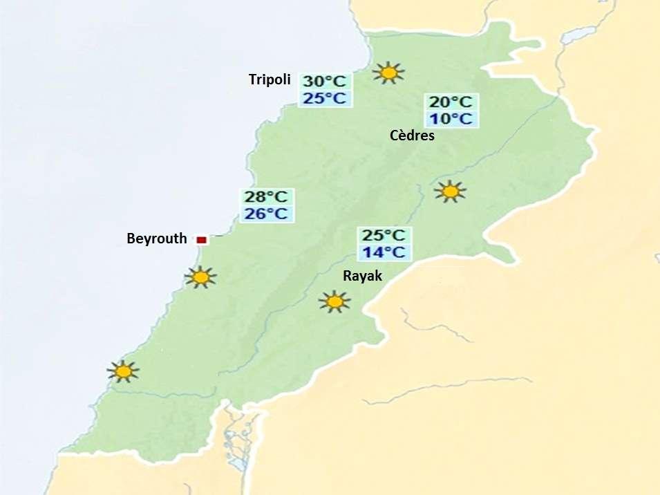
2 Short Description To assess climatic variability and climate change in Lebanon, the climatic parameters (precipitation and minimal and maximal temperature) were studied, through registered data at Beirut International Airport, of the four principal meteorological stations in Lebanon: Tripoli, Beirut, Cedars and Rayak from 193 to 21 (were available).
3 CLIMATIC CHARACTERISTICS OF LEBANON Lebanon is located on the eastern coast of the Mediterranean Sea. The Mediterranean Climate is characterized by mild rainy winters and hot dry summers. A Mediterranean climate benefits from the dampening effect of the sea. In winter the sea temperature is higher than the air temperature, and the sea thus warms up the air masses which are then blown over the coastal regions. In summer the sea temperature is lower than the air temperature, and the cool breeze from the sea contributes to the reduction of the coastal temperatures.

4 Topographic characteristics of Lebanon Lebanon s topography can be divided into three features, a coastal strip, mountain ranges, and an inland plateau. The Western mountain range plays a key influencing role on the climatic pattern of the inland plateau. While the climatic pattern of the western side of the Western mountain range exhibits Maritime characteristics, the climatic pattern of the eastern side of the Western mountain range exhibits Continental characteristics. Continental climates are typically marked by large annual or daily temperature amplitudes, low relative humidity, and moderate to low rainfall.
5 STUDY APPROACH Through statistical analysis, and based on authentic numeric records collected from the department of Meteorology at Beirut International Airport, the dayto-day minimal and maximal temperatures and rainfall records recorded in four different meteorological stations, represent the general geographical aspect of Lebanon: Beirut and Tripoli stations are coastal cities located respectively in the middle and in the North of the coast of Lebanon. Cedars is a mountainous region and Rayak is considered internal.
6 A- Temperatures Analysis 1- Average TTmin 15 Annuelles - Cèdres Mars Cèdres -1 2 Juillet - Cèdres 1
7 Min de TTmin Annuelles - Cèdres Mars - Cèdres Août - Cèdres
8 Max de TTmin 4 Annuelles - Cèdres 2 1 Fevrier - Cèdres Juillet - Cèdres
9
10 Fonction statistiques: Fonction Moving Average B- RAINFALL Somme des RR - Tripoli Somme de RR - Beirut Somme des RR - Rayak Somme des RR - Cèdres
11 Annual distribution of Rainfall 1- Fonction statistiques: Fonction Trendline Somme des RR - Tripoli y = x Somme des RR - Beirut y =.22x Somme des RR - Rayak Somme des RR - Cèdres y = -.771x y = -1.65x + 15
12 2- Percentage years RR which are lower than the average, according to periods of 1, 15,2 and 25 years: Tripoli Beyrouth Rayak Cèdres Tripoli _ Beyrouth Rayak _ Cèdres _ _ Tripoli Beyrouth Rayak Cèdres _ Tripoli _ Beyrouth Rayak _ Cèdres _
13 Monthly distribution of Rainfall statistical functions: Linear Trendline: It was noted that for months there where RR diminish or even remain constant. And likewise, increased RR appears in several months and all stations. In the years 27, 28 and 29, and only in Rayak and the Cedars, the dry months of low or RR (April September) are a high rainfall.
14 Seasonal distribution of Rainfall 1- Applying the "Linear Trendline" near-constant movement (slope of the equation ) at Tripoli, Beirut and Rayak: All stations / All seasons Cedar a- Winter: 15 1 Somme des RR - Cèdres- Hiver 5 y = x
15 Somme des RR - Cèdres y = x b- Printemps: 1 c- Eté Somme des RR - Cèdres y =.128x d-automne 1 5 Somme des RR - Cèdres y = -3.86x + 4.2
16 2- extreme years (Winter and Spring): HIVER % de la majorité des années Intervalles % des années extrêmes Intervalles Années extrêmes Tripoli 96.88% [1-75[ 3.12% [8-9[ Beyrouth 96.1% [2-675 [ Rayak 96.88% [15-575[ Cèdres 87.8% [1-95 [ PRINTEMPS % de la majorité des années Intervalles 2.6% 3% 1.56% 1.56% 4.88% 2.44% 4.88% % des années extrêmes [15-175[ [9-625[ [6-625[ [7-725[ [-5[ [5-1[ [9-1[ Intervalles Années extrêmes Tripoli 98.8% [-2[ 1.92% [26-28[ Beyrouth 94.81% [1-19[ Rayak 96.83% [-13[ 2.6% 1.3% 1.3% 1.59% 1.59% [-1[ [26-27[ [33-34[ [17-18[ [2-21[ Cèdres 97.5% [2-2[ 2.5% [24-26[
17 2- extreme years (Summer and Fall): ETÉ % de la majorité des années Intervalles Tripoli 9.8% [-4[ Beyrouth 96.1% [-15[ % des années extrêmes 1.96% 1.96% 1.3% 1.3% 1.3% Intervalles [7-8[ [16-17[ [3-35[ [5-55[ [65-7[ Rayak 96.88% [-7[ 3.12% [16-18[ Années extrêmes Cèdres 95% [-4[ 5% [55-65[ AUTOMNE % de la majorité des années Intervalles Tripoli 94.23% [9-6[ Beyrouth 93.51% [8-44[ Rayak 96.88% [3-39[ Cèdres 9% [1-55[ % des années extrêmes 3.85% 1.92% 1.3% 1.3% 3.9% 1.56% 1.56% 7.5% 2.5% Intervalles [-3[ [63-66[ [-2[ [6-8[ [44-5[ [-3[ [48-51[ [-5[ [75-8[ Années extrêmes
18 Seasonal distribution of several parameters 3. Comparison between different periods of years: In order to compare the last period to the other, a study was conducted as follows: A calculation of the following variables was performed each season for each station: Min and Max TT TT min and max TT Average min and max average general TT RR sum
19 Standards values of each parameter at the 4 Seasons in Tripoli: TRIPOLI Max de TT max Min de TT max Moyenne de TT max Max de TT min Min de TT min Moyenne TT min TT moyenne Somme de RR Hiver Printemps Été Automne
20 3. Comparison between different periods of years: Then there is provided a calculation of the percentage of years having values lower than standard: TT: Percentage RR: Percentage => number of hot Years => number of low RR Years Max TTmax Min de TT max Moyenne TTmax Max TTmin Min TTmin Moyenne TT min T moyenne Somme RR
21 3. Comparison between different periods of years: b- Spring (Beirut) Printemps - Beyrouth Max de TT max c- Eté (Tripoli) Min de TT max AVG de max Max de TT min Min de TT min AVG de TT min TT moyenne Somme de RR Eté Tripoli Max de TT max Min de TT max AVG de max Max de TT min Min de TT min AVG de TT min TT moyenne Somme de RR
22 3. Comparison between different periods of years: d- Fall (Beirut) Automne Beyrouth Max de TT max Min de TT max AVG de max Max de TT min Min de TT min AVG de TT min TT moyenne Somme de RR

 Martonne index«i» Where P = total annual")
23 Climat Classification Modern climate classification is based on parameters calculable climate (temperature, humidity, etc.) Martonne index«i» Where P = total annual rainfall T = Average annual temperature
24 Climat Classification 4 Martonne index- Tripoli 3 2 1=A 2=SA 3=SH 4=H 1 4 Martonne index- Beirut 3 2 1=A 2=SA 3=SH 4=H 1
25 Climate classification % aridity over different periods Tripoli A SA SH H Cedars A SA SH H Beirut A SA SH H Rayak A SA SH H
26 RESULTS Over the past two decades in Lebanon, there was the following: Cedars: The Average, Min and Max TT min and max are much higher than the average of the past years, reaching an increase of 3.9 C in August The annual amount of precipitation is greatly diminished, but increased in summer and during the dry months supposed especially in 27, 28 and 29.
27 Tripoli: The Average, Min and Max TT min are almost constant. But the average annual TT max increased by 1.8 C, and especially in July (2.5 C). In addition, the Min and Max TT max amounted in March, April, June, July and October. The annual amount of precipitation tends to decrease slightly, especially in the months of January, April and May, and the season Winter and Spring. Rayak: Average annual TT min and max increased by> 1 C, and reaching 1.9 C in August The Min and Max are almost invariant, except for the months of January, February and March. The annual amount of precipitation tends to decrease slightly. In winter it reduces the most, but in Summer, 2 exceptional and high values were recorded (27 and 29).
28 Beirut: The Average Annual TR min increased by 2.3 C compared to 6 and 7, and almost 1 C from years 3, 4 and 5. Very high values are recorded especially in the month of summer, where the increase reached 3.9 C in August The Min and Max TT TT min and max remained almost stable and the average annual TT max. The annual amount of precipitation is constant. However, it increased slightly in September and October; In spring, the sum decreases, and recorded in summer high outstanding value of 65 mm in 29.
29 Conclusion Over the two decades, the minimal and maximal temperatures in Lebanon have undergone unusual changes, which were reflected by high values of the average, the minimum and the maximum. we noticed that a close elevation has already been detected in the average of the minimal and maximal temperatures in all stations. Certainly, the elevation of the temperature and the fluctuation of the precipitation predict an anxious environmental future, where the climate is changing. Lebanon is already influenced by the global climate change particularly on water resources.

30 Thanks for your Attention
Name: Date: Day/Period: CGC1P1: Interactions in the Physical Environment. Factors that Affect Climate
 Name: Date: Day/Period: CGC1P1: Interactions in the Physical Environment PART A: Weather and Climate Factors that Affect Climate 1. The words weather and climate are often incorrectly used interchangeably.
- wet tropical climate
 (1 of 13) Further Reading: Chapter 10 of the text book Outline - wet tropical climate - coastal trade wind climate - wet-dry and monsoon climate - dry tropical climate (2 of 13) Introduction Previously,
GEOGRAPHY UNIT 2 REVIEW. 1. The daily atmospheric conditions, such as heat, moisture and air movement for a particular area are known as
 UNIT 2 REVIEW GEOGRAPHY Name: 1. The daily atmospheric conditions, such as heat, moisture and air movement for a particular area are known as 2. The average conditions of the weather for a long period
Social Studies CHAPTER 2: PART 2 CLIMATE AND WEATHER
 Social Studies CHAPTER 2: PART 2 CLIMATE AND WEATHER Climate Weather and Identity Climate and weather have a large influence on how Canadians build their identity. We will study the factors that contribute
Latitude Altitude (Elevation) Proximity to large bodies of water Ocean Currents. larger. concentrated. direct. heating. heating.
 Proximity to large bodies of water Ocean Currents. larger. concentrated. direct. heating. heating.") Climographs Climographs Climographs Roles of Temperature and Precipitation on Climate Roles of Temperature and Precipitation on Climate : Altitude (Elevation) Proximity to large bodies of water Ocean Currents
Climographs Climographs Climographs Roles of Temperature and Precipitation on Climate Roles of Temperature and Precipitation on Climate : Altitude (Elevation) Proximity to large bodies of water Ocean Currents
CLIMATES IN SOUTH AFRICA
 CLIMATES IN SOUTH AFRICA South Africa has various climates throughout the country. It is in the Southern Hemisphere and is surrounded by ocean except for at its Northern borders. South Africa s climates
Final Report August 2005
 2.0 REGIONAL STUDY AREA 2.1 Regional Setting 2.1.1 Topography The Los Angeles Region is located within the western portion of the Transverse Ranges Geomorphic Province. The San Andreas transform fault
Disaster risk reduction in Mongolia
 Disaster risk reduction in Mongolia Information Research Institute of Meteorology, Hydrology and Environmental N.Baljinnyam Jaipur, India 216.3.1 Outline Climate regime of Mongolia Present Climate change
Exit Ticket: Coriolis Effect
 Exit Ticket: Coriolis Effect 1. How does the Coriolis Effect influence the path of projectiles or wind traveling through the atmosphere? Causes them to curve 2. In which direction does the Coriolis Effect
Cal Poly Lands located in San Luis Obispo County experience a collection of idyllic microclimates
 Climate Margot McDonald, College of Architecture and Environmental Design Cal Poly Lands located in San Luis Obispo County experience a collection of idyllic microclimates due to their geographical position
Bell Ringer. taking next year? 1. This is the first day of the last term. Set. 2. What science are you planning on
 Bell Ringer 1. This is the first day of the last term. Set a specific goal for these last 2.5 months (not just get good grades or don t fail or wake up on time. How are you going to do these things. Set
Tropical Pacific Ocean remains on track for El Niño in 2014
 1 of 10 3/06/2014 3:33 PM ENSO Wrap-Up Current state of the Pacific and Indian Ocean Tropical Pacific Ocean remains on track for El Niño in 2014 Issued on Tuesday 3 June 2014 Product Code IDCKGEWWOO The
Rice Yield And Dangue Haemorrhagic Fever(DHF) Condition depend upon Climate Data
 Condition depend upon Climate Data") Rice Yield And Dangue Haemorrhagic Fever(DHF) Condition depend upon Climate Data Dr Lai Lai Aung, Assistant Director( Met Service) Dr Khaing Khaing Soe Assistant Director(Public Health) Dr Thin Nwe htwe
Rice Yield And Dangue Haemorrhagic Fever(DHF) Condition depend upon Climate Data Dr Lai Lai Aung, Assistant Director( Met Service) Dr Khaing Khaing Soe Assistant Director(Public Health) Dr Thin Nwe htwe
Atmospheric Waves James Cayer, Wesley Rondinelli, Kayla Schuster. Abstract
 Atmospheric Waves James Cayer, Wesley Rondinelli, Kayla Schuster Abstract It is important for meteorologists to have an understanding of the synoptic scale waves that propagate thorough the atmosphere
Climate Scavenger Hunt
 Climate Scavenger Hunt ELA & Science Grades 4nd to 9th Created by Piyush & Ilaxi Directions to use Climate Scavenger Hunt Purpose : At the end of this scavenger hunt on climate students will be able to
Jeopardy Q $100 Q $100 Q $100 Q $100 Q $100 Q $200 Q $200 Q $200 Q $200 Q $200 Q $300 Q $300 Q $300 Q $300 Q $300 Q $400 Q $400 Q $400 Q $400 Q $400
 Jeopardy Grab Bag Review Grab Bag Review 2 Biomes Climate Factors that affect climate Q $100 Q $200 Q $300 Q $400 Q $500 Q $100 Q $100 Q $100 Q $100 Q $200 Q $200 Q $200 Q $200 Q $300 Q $300 Q $300 Q $300
Canada s vast size creates a diverse range of weather conditions and climatic conditions. Warming trend for last 10 years Wet Spring Dry five summers
 Chapter 4 Weather and Climate Canada s vast size creates a diverse range of weather conditions and climatic conditions. Weather examples: Rainy today Snow tomorrow Fog on Wednesday 23 degree C today High
Validation Study of the Lufft Ventus Wind Sensor
 Weather Forecasts Renewable Energies Air and Climate Environmental Information Technology METEOTEST Cooperative Fabrikstrasse 14, CH-3012 Bern Tel. +41 (0)31 307 26 26 Fax +41 (0)31 307 26 10 office@meteotest.ch,
1.3: CLIMATE GEOGRAPHY. pgs
 1.3: CLIMATE GEOGRAPHY pgs. 76-89 INTRODUCTION WEATHER: Is the combination of temperature, precipitation, cloud cover and wind that we experience EACH DAY. Example: 22 0 C and clear skies. CLIMATE: The
Bell Work. Compare and contrast warm fronts and cold fronts. What type of weather is associated with a high pressure and low pressure systems?
 Daily Routine Sit in your appropriate seat quietly Have all necessary materials out All back packs on the floor All cell phones on silent and away in backpacks All music devices off and headphones out
LAB H - ATMOSPHERE AND CLIMATE LAB II STABILITY AND PRECIPITATION PATTERNS
 Introduction LAB H - ATMOSPHERE AND CLIMATE LAB II STABILITY AND PRECIPITATION PATTERNS This lab will provide students with the opportunity to become familiar with the concepts of atmospheric stability
ELA & Science Grades 4 nd to 9 th Created by Piyush & Ilaxi
 ELA & Science Grades 4 nd to 9 th Created by Piyush & Ilaxi 2014 Brilliant Classes by Piyush Page 1 Directions to use Climate Scavenger Hunt Purpose : At the end of this scavenger hunt on climate students
LAB H - ATMOSPHERE AND CLIMATE LAB II STABILITY AND PRECIPITATION PATTERNS
 Introduction LAB H - ATMOSPHERE AND CLIMATE LAB II STABILITY AND PRECIPITATION PATTERNS This lab will provide students with the opportunity to become familiar with the concepts of atmospheric stability
Notepack 41. Aim: What factors determine the climate of a certain area? Do Now: What is the difference between weather and climate?
 Notepack 41 Aim: What factors determine the climate of a certain area? Do Now: What is the difference between weather and climate? WEATHER VS. CLIMATE Weather atmospheric conditions at a certain location
Meteorology of Monteverde, Costa Rica 2007
 Meteorology of Monteverde, Costa Rica 2007 Technical Report submitted to the Monteverde Institute Andrew J. Guswa, Associate Professor, Picker Engineering Program Amy L. Rhodes, Associate Professor, Department
Applied Earth Science Climate Exam Practice Questions Page 1
 Name: 1. Which combination of climate factors generally results in the coldest temperatures? A) low elevation and low latitude B) low elevation and high latitude C) high elevation and low latitude D) high
SESSION THREE: FACTORS THAT INFLUENCE WEATHER IN SOUTH AFRICA
 SESSION THREE: FACTORS THAT INFLUENCE WEATHER IN SOUTH AFRICA KEY CONCEPTS: In this section we will focus on the following aspects: Factors determining the weather of South Africa Influence of the oceans
Natural Regions of the World
 Natural Regions of the World Revision for Competitive Exams 10x10learning.com 1 Concept of Natural Regions provides a framework for understanding the diversity of physical and biological environment Taiga
Water on Earth. How do oceans relate to weather and the atmosphere? Solar Radiation and Convection Currents
 Earth is often called the Blue Planet because so much of its surface (about 71%) is covered by water. Of all the water on Earth, about 96.5% is held in the world s oceans. As you can imagine, these oceans
LONG- TERM CHANGE IN PRE- MONSOON THERMAL INDEX OVER CENTRAL INDIAN REGION AND SOUTH WEST MONSOON VARIABILITY
 LONG- TERM CHANGE IN PRE- MONSOON THERMAL INDEX OVER CENTRAL INDIAN REGION AND SOUTH WEST MONSOON VARIABILITY *S.S. Dugam Indian Institute of Tropical Meteorology, Pune-411008 *Author for Correspondence
Wind Regimes 1. 1 Wind Regimes
 Wind Regimes 1 1 Wind Regimes The proper design of a wind turbine for a site requires an accurate characterization of the wind at the site where it will operate. This requires an understanding of the sources
46 Chapter 8 Statistics: An Introduction
 46 Chapter 8 Statistics: An Introduction Activity 5 Continued Box 4 1. The median is 6. The mode is 5. The mean is about 7 (6.8). 2. The median and the mode were unchanged, but the mean increased significantly.
Urban Environmental Climate Maps for Urban Planning Considering Urban Heat Island Mitigation in Hiroshima
 Academic Article Journal of Heat Island Institute International Vol. 9-2 (2014) Urban Environmental Climate Maps for Urban Planning Considering Urban Heat Island Mitigation in Hiroshima Kaoru Matsuo* 1
Influences on Weather and Climate Weather and Climate. Coriolis Effect
 Influences on Weather and limate Weather and limate oriolis Effect 1 limate is defined as the common weather conditions in one area over a long period of time. Temperature, humidity, rainfall, and wind
Ecology. Professor Andrea Garrison Biology 3A Illustrations 2014 Cengage Learning unless otherwise noted
 Ecology Professor Andrea Garrison Biology 3A Illustrations 2014 Cengage Learning unless otherwise noted Ecology Ecology (oikos = house) is the study of where an organism lives and all the interactions
Applied Multivariate analysis on Precipitation and Temperature data (Barada and Awaj Basin)
") Training Workshop on Environment Statistics Damascus, -8 April 00 Applied on Precipitation and Temperature data (Barada and Awaj Basin) Mazen Abou Abdallah it_div@acsad.org - ACSAD,Syria April 00, Damascus
Training Workshop on Environment Statistics Damascus, -8 April 00 Applied on Precipitation and Temperature data (Barada and Awaj Basin) Mazen Abou Abdallah it_div@acsad.org - ACSAD,Syria April 00, Damascus
Ocean Current Worksheet
 Ocean Current Worksheet Temperature Affects and Surface Currents: Surface waters of the Earth s oceans are forced to move, primarily by winds. Where winds blow in the same direction for a long period of
OCN 201 Lab Fall 2009 OCN 201. Lab 9 - El Niño
 OCN 201 Lab Fall 2009 OCN 201 Lab 9 - El Niño El Niño is probably one of the most widely publicized oceanic phenomena. If there s one single reason for that it s probably the fact that El Niño s presence
Climate briefing. Wellington region, February Alex Pezza and Mike Thompson Environmental Science Department
 Climate briefing Wellington region, February 2016 Alex Pezza and Mike Thompson Environmental Science Department For more information, contact the Greater Wellington Regional Council: Wellington PO Box
Blue crab ecology and exploitation in a changing climate.
 STAC Workshop 28 March 2017 Blue crab ecology and exploitation in a changing climate. Thomas Miller Chesapeake Biological Laboratory University of Maryland Center for Environmental Science Solomons, MD
Unit 2 World Climate Patterns
 Unit 2 World Climate Patterns Weather the day to day or short term conditions of the atmosphere. Weather includes variables such as temperature, precipitation, humidity, cloud cover, wind, and air pressure.
Air Pressure and Wind
 Air Pressure and Wind 19.1 Understanding Air Pressure Air Pressure Defined Air pressure is the pressure exerted by the weight of air. Air pressure is exerted in all directions down, up, and sideways. The
The Child. Mean Annual SST Cycle 11/19/12
 Introduction to Climatology GEOGRAPHY 300 El Niño-Southern Oscillation Tom Giambelluca University of Hawai i at Mānoa and Pacific Decadal Oscillation ENSO: El Niño-Southern Oscillation PDO: Pacific Decadal
6.28 PREDICTION OF FOG EPISODES AT THE AIRPORT OF MADRID- BARAJAS USING DIFFERENT MODELING APPROACHES
 6.28 PREDICTION OF FOG EPISODES AT THE AIRPORT OF MADRID- BARAJAS USING DIFFERENT MODELING APPROACHES Cecilia Soriano 1, Darío Cano 2, Enric Terradellas 3 and Bill Physick 4 1 Universitat Politècnica de
Global Weather Patterns
 Global Weather Patterns AZ State Standards Concept 2: Energy in the Earth System (Both Internal and External) Understand the relationships between the Earth s land masses, oceans, and atmosphere. PO 2.
Conditions for Offshore Wind Energy Use
 Carl von Ossietzky Universität Oldenburg Institute of Physics Energy Meteorology Group Detlev Heinemann Conditions for Offshore Wind Energy Use Detlev Heinemann ForWind Carl von Ossietzky Universität Oldenburg
Chapter. Air Pressure and Wind
 Chapter Air Pressure and Wind 19.1 Understanding Air Pressure Air Pressure Defined Air pressure is the pressure exerted by the weight of air. 19.1 Understanding Air Pressure Air Pressure Defined Air pressure
Nevis Hulme Gairloch High School John Smith Invergordon Academy. Gairloch High School / Invergordon Academy
 Nevis Hulme Gairloch High School John Smith Invergordon Academy 1 Gairloch High School / Invergordon Academy ATMOSPHERIC CIRCULATION The Three Cell Model Global Winds The ITCZ The purpose of this presentation
Climate variability and expected changes in Albania
 Workshop on climate risks and vulnerabilities of Albania s energy sector Climate variability and expected changes in Albania Eglantina Demiraj Bruci Climate Change Programme, MoEFWA 10 March 2009, Tirana
Climate variability and expected changes in Albania
 Workshop on climate risks and vulnerabilities of Albania s energy sector Climate variability and expected changes in Albania Eglantina Demiraj Bruci Climate Change Programme, MoEFWA 10 March 2009, Tirana
Chapter- 9. Multiple Choice Questions
 Chapter- 9 Multiple Choice Questions 1. The low-latitude climates: a. are located along the equator b. are located between the tropics of cancer and capricorn c. do not include the ITCZ d. are restricted
El Niño climate disturbance in northern Madagascar and in the Comoros
 El Niño climate disturbance in northern Madagascar and in the Comoros Rabeharisoa J. M.¹, Ratiarison A.¹, Rakotovao N.¹, Salim Ahmed Ali¹ ² (*) ¹ Laboratoire de Dynamique de l Atmosphère, du Climat et
Canada s Natural Systems. Canadian Geography 1202
 Canada s Natural Systems Canadian Geography 1202 Canada s Natural Systems Natural System: A system found in nature Here are the four natural systems that we will explore in the next few weeks 1. Canada
Physical Geography. Physical Geography III of the United States and Canada. Formation of Great Lakes. Climates of North America. Definitions 2/21/2013
 Physical Geography III of the United States and Canada Ancient Glacial Lakes As the Ice Age ended, areas of North America beyond the terminal moraine were flooded with melt water Prof Anthony Grande AFG
Overview. Learning Goals. Prior Knowledge. UWHS Climate Science. Grade Level Time Required Part I 30 minutes Part II 2+ hours Part III
 Draft 2/2014 UWHS Climate Science Unit 3: Natural Variability Chapter 5 in Kump et al Nancy Flowers Overview This module provides a hands-on learning experience where students will analyze sea surface
Cyprus Climate Change Risk Assessment (CCRA)
") Cyprus Climate Change Risk Assessment (CCRA) Αναλυτική περιγραφή των σεναρίων κλιματικής αλλαγής: Αποτελέσματα Δρ. Απόστολος Βουλγαράκης (Imperial College London) & Δρ. Χρήστος Γιαννακόπουλος (Εθνικό Αστεροσκοπείο
Cyprus Climate Change Risk Assessment (CCRA) Αναλυτική περιγραφή των σεναρίων κλιματικής αλλαγής: Αποτελέσματα Δρ. Απόστολος Βουλγαράκης (Imperial College London) & Δρ. Χρήστος Γιαννακόπουλος (Εθνικό Αστεροσκοπείο
INFLUENCE OF ENVIRONMENTAL PARAMETERS ON FISHERY
 Chapter 5 INFLUENCE OF ENVIRONMENTAL PARAMETERS ON FISHERY 5. Introduction Environmental factors contribute to the population dynamics and abundance of marine fishery. The relationships between weather,
OBSERVATIONAL ANALYSIS OF CHANGES IN EXTREME EVENTS IN EMILIA-ROMAGNA
 OBSERVATIONAL ANALYSIS OF CHANGES IN EXTREME EVENTS IN EMILIA-ROMAGNA C. Cacciamani, R.Tomozeiu,V.Pavan Servizio Meteorologico Regionale ARPA, Bologna, Italy OUTLINE data-base for STARDEX project investigation
Topic 4 Temperature, Atmospheric Circulation and Climate. Temperature Concepts and Measurement 10/2/2017. Thermometer and Instrument Shelter
 Topic 4 Temperature, Atmospheric Circulation and Climate Temperature Controls Global Temp. Patterns Atmospheric Circulation Primary High and Low Pressure Areas Global Circulation Model Local Winds Ocean
GEOS 513 ENSO: Past, Present and Future
 GEOS 513 ENSO: Past, Present and Future Jessica Conroy Department of Geosciences Stephen W. Bieda, III Department of Atmospheric Sciences February 22, 2006: Regional Teleconnections (Observations) References:
First of all, you should know that weather and climate are not the same thing.
 First of all, you should know that weather and climate are not the same thing. WEATHER IS: Short term Limited area Can change rapidly Difficult to predict WEATHER is what s happening outside your window
Atmospheric Rossby Waves in Fall 2011: Analysis of Zonal Wind Speed and 500hPa Heights in the Northern and Southern Hemispheres
 Atmospheric Rossby Waves in Fall 211: Analysis of Zonal Wind Speed and 5hPa Heights in the Northern and Southern s Samuel Cook, Craig Eckstein, and Samantha Santeiu Department of Atmospheric and Geological
A STUDY OF THE PHYSICAL ENVIRONMENT AND WATER CIRCULATION IN FARWA LAGOON, LIBYA
 131 A STUDY OF THE PHYSICAL ENVIRONMENT AND WATER CIRCULATION IN FARWA LAGOON, LIBYA 1 2 M. GERGES and A. DURGHAM 1 UNESCO E:x:pex>t at MRC 2Marine Scientist at MB.C, TX'ipoU, Libya, S.P.L.A.J. ABSTRACT
Global Climate Systems and Climate Change
 Global Climate Systems and Climate Change 1) An area defined by characteristic, long-term weather patterns is called A) a biome. B) an average weather place. C) an ecosystem. D) a climatic region. 2) Climate
18.1 Understanding Air Pressure 18.1 Understanding Air Pressure Air Pressure Defined Measuring Air Pressure Air pressure barometer
 18.1 Understanding Air Pressure 18.1 Understanding Air Pressure Air Pressure Defined Air pressure is the pressure exerted by the weight of air. Air pressure is exerted in all directions down, up, and sideways.
Your web browser (Safari 7) is out of date. For more security, comfort and the best experience on this site: Update your browser Ignore
 is out of date. For more security, comfort and the best experience on this site: Update your browser Ignore") Your web browser (Safari 7) is out of date. For more security, comfort and the best experience on this site: Update your browser Ignore L A NIÑA El Niño-Southern Oscillation (ENSO) For the complete encyclopedic
Your web browser (Safari 7) is out of date. For more security, comfort and the best experience on this site: Update your browser Ignore L A NIÑA El Niño-Southern Oscillation (ENSO) For the complete encyclopedic
Comparison of Predicted and Measured Shoaling at Morro Bay Harbor Entrance, California
 Comparison of Predicted and Measured Shoaling at Morro Bay Harbor Entrance, California by Edward F. Thompson, Inocencio P. DiRamos, and Robert R. Bottin, Jr. PURPOSE: This Coastal and Hydraulics Engineering
Geography & Climate. All species have limits to their distributions across the globe
 Geography & Climate All species have limits to their distributions across the globe To understand species ranges, we need to understand the physical template and climate This is fundamental to biogeography
SURFACE CURRENTS AND TIDES
 NAME SURFACE CURRENTS AND TIDES I. Origin of surface currents Surface currents arise due to the interaction of the prevailing wis a the ocean surface. Hence the surface wi pattern (Figure 1) plays a key
Deep Water Currents Lab
 Deep Water Currents Lab Background: Anyone visiting the seashore is struck by the constant motion of water traveling on the surface of the ocean in the form of waves. But beneath the ocean's surface, water
APPENDIX B NOAA DROUGHT ANALYSIS 29 OCTOBER 2007
 APPENDIX B NOAA DROUGHT ANALYSIS 29 OCTOBER 2007 ENSO Cycle: Recent Evolution, Current Status and Predictions Update prepared by Climate Prediction Center / NCEP October 29, 2007 Outline Overview Recent
STUDY GUIDE. The Land. Physical Geography of Europe. Chapter 11, Section 1. Terms to Know DRAWING FROM EXPERIENCE ORGANIZING YOUR THOUGHTS
 For use with textbook pages 271 276. The Land Terms to Know dikes Large banks of earth and stone that hold back water (page 272) polder Drained area of land (page 272) glaciation The process in which glaciers
Weather of the Promised Land
 Biblical Geography Basics NT110 LESSON 10 of 10 Jack Beck, Ph.D. Experience: Author and faculty member at Jerusalem University College in Israel Introduction There s geography in my Bible. Remember, we
Station 1: Ocean Currents Use the ocean currents map copied from page 4 of the ESRT and the passage to answer the questions that follow.
 Station 1: Ocean Currents Use the ocean currents map copied from page 4 of the ESRT and the passage to answer the questions that follow. The Map: Questions: 1. Name the cool current off the West coast
Deserts and Desert Environments
 Deserts and Desert Environments Introduction Aeolian geomorphology is the study of the effect of wind on Earth surface processes and landforms Wind: the movement of air from one place to another, specifically
1 What Causes Climate?
 Section 1 What Causes Climate? 1 What Causes Climate? Objectives After this lesson, students will be able to I.4.1.1 Identify factors that influence temperature and precipitation. I.4.1.2 Explain what
Full Classification acc. to IEC for SoDAR AQ510 Wind Finder. Vincent Camier, Managing Director, Ammonit Measurement GmbH
 Full Classification acc. to IEC 61400-12-1 for SoDAR AQ510 Wind Finder Vincent Camier, Managing Director, Ammonit Measurement GmbH Ammonit Company Profile German company, based in Berlin +25 years of know-how
Atomspheric Waves at the 500hPa Level
 Atomspheric Waves at the 5hPa Level Justin Deal, Eswar Iyer, and Bryce Link ABSTRACT Our study observes and examines large scale motions of the atmosphere. More specifically it examines wave motions at
Inuvik Wind Monitoring Update 2016
 Inuvik Wind Monitoring Update 2016 Source: MACA Prepared for By Jean Paul Pinard, P. Eng., PhD. 703 Wheeler St., Whitehorse, Yukon Y1A 2P6 Tel. (867) 336 2977; Email jpp@northwestel.net March 31, 2016
Ocean Wave Forecasting
 Ocean Wave Forecasting Jean-Raymond Bidlot* Marine Prediction Section Predictability Division of the Research Department European Centre for Medium-range Weather Forecasts (E.C.M.W.F.) Reading, UK * With
Nolan Doesken. Colorado Climate Center.
 Nolan Doesken Colorado Climate Center Presented to: Colorado Conservation Tillage Association, Greeley, CO, February 1-2, 1 2005 http://ccc.atmos.colostate.edu Prepared by Odie Bliss 1 Key Features of
Lornshill Academy. Geography Department Higher Revision Physical Environments - Atmosphere
 Lornshill Academy Geography Department Higher Revision Physical Environments - Atmosphere Physical Environments Atmosphere Global heat budget The earth s energy comes from solar radiation, this incoming
Weather EOG Review Questions
 Weather EOG Review Questions 1. Which statement best describes runoff? A Water vapor cools off and changes into water droplets. B Water in the form of rain, snow, sleet, or hail falls from clouds. C Precipitation
ECO 745: Theory of International Economics. Jack Rossbach Fall Lecture 6
 ECO 745: Theory of International Economics Jack Rossbach Fall 2015 - Lecture 6 Review We ve covered several models of trade, but the empirics have been mixed Difficulties identifying goods with a technological
Local Winds. Please read Ahrens Chapter 10
 Local Winds Please read Ahrens Chapter 10 Scales of Motion Microscale: meters Turbulent eddies Formed by mechanical disturbance or convection Lifetimes of minutes Mesoscale: km s to 100 s of km s Local
NordFoU: External Influences on Spray Patterns (EPAS) Report 16: Wind exposure on the test road at Bygholm
 Report 16: Wind exposure on the test road at Bygholm") NordFoU: External Influences on Spray Patterns (EPAS) Report 16: Wind exposure on the test road at Bygholm Jan S. Strøm, Aarhus University, Dept. of Engineering, Engineering Center Bygholm, Horsens Torben
NordFoU: External Influences on Spray Patterns (EPAS) Report 16: Wind exposure on the test road at Bygholm Jan S. Strøm, Aarhus University, Dept. of Engineering, Engineering Center Bygholm, Horsens Torben
Chapter 3 Atmospheric Thermodynamics
 Chapter 3 Atmospheric Thermodynamics Spring 2017 Partial Pressure and Dalton Dalton's law of partial pressure: total pressure exerted by a mixture of gases which do not interact chemically is equal to
Agronomy 406 World Climates
 Agronomy 406 World Climates January 30, 2018 Monsoons. Ocean properties and circulation. Review for today: Online textbook: 1.3.1 (Sea water) Composition and properties. For Thursday: Rahmstorf, S.: The
Arizona Climate Summary September 2012
 Arizona Climate Summary September 2012 Summary of conditions for August 2012 August 2012 Temperature and Precipitation Summary August 1 st 15 th : During the month of August, at least one location received
Diminished Windstorm Frequency in Southwest British Columbia and a Possible Association With the Pacific Decadal Oscillation Regime Shift of
 Diminished Windstorm Frequency in Southwest British Columbia and a Possible Association With the Pacific Decadal Oscillation Regime Shift of 1976-77 Mantua, N. M. Wolf Read PhD Program Forest Science University
- terminology. Further Reading: Chapter 07 of the text book. Outline. - characteristics of ENSO. -impacts
 (1 of 14) Further Reading: Chapter 07 of the text book Outline - terminology - characteristics of ENSO -impacts (2 of 14) Today: Introduction We want to look at another source of variability in the atmosphere
OCEANOGRAPHY STUDY GUIDE
 OCEANOGRAPHY STUDY GUIDE Chapter 2 Section 1 1. Most abundant salt in ocean. Sodium chloride; NaCl 2. Amount of Earth covered by Water 71% 3. Four oceans: What are they? Atlantic, Pacific, Arctic, Indian
Goals for today: continuing Ch 8: Atmospheric Circulation and Pressure Distributions. 26 Oct., 2011
 Goals for today: 26 Oct., 2011 continuing Ch 8: Atmospheric Circulation and Pressure Distributions Examples of synoptic scale and mesoscale circulation systems that are driven by geographic diversity in
National Weather Service
 National Weather Service The North American Monsoon Until the late 1970s, there was serious debate about whether a monsoon truly existed in North America. However, considerable research, which culminated
Goal: Describe the principal features and characteristics of monsoons
 Overview and description of major tropical monsoons Monsoon clouds near Kolkata India Goal: Describe the principal features and characteristics of monsoons Published Online March 25, 2010 Science DOI:
PGF. Pressure Gradient. Wind is horizontal movement of the air or other word air in motion. Forces affecting winds 2/14/2017
 Winds Wind is horizontal movement of the air or other word air in motion. Forces affecting winds 1. Pressure gradient force a. High pressure flows to low pressure b. Pressure gradient = difference in pressure
Government of Newfoundland and Labrador Department of Environment and Conservation Water Resources Management Division
 Government of Newfoundland and Labrador Department of Environment and Conservation Water Resources Management Division Real Time Water Quality Monthly Report Leary s Brook- St. John s NL April 2009 General
Characterization of Boundary-Layer Meteorology During DISCOVER-AQ
 Characterization of Boundary-Layer Meteorology During DISCOVER-AQ Daniel M. Alrick and Clinton P. MacDonald Sonoma Technology, Inc. Gary A. Morris St. Edward s University for Texas Air Quality Research
FISHERIES BLUE MOUNTAINS ADAPTATION PARTNERSHIP
 FISHERIES A warming climate, by itself, substantially affects the hydrology of watersheds in the Blue Mountains. Among the key hydrologic changes projected under all scenarios for the 2040s and beyond
Small- and large-scale circulation
 The Earth System - Atmosphere II Small- and large-scale circulation Atmospheric Circulation 1. Global atmospheric circulation can be thought of as a series of deep rivers that encircle the planet. 2. Imbedded