Climate Change and Security:
|
|
|
- Baldric Owen
- 5 years ago
- Views:
Transcription
1 Climate Change and Security: Ideas & Inspiration from Annapolis Angela Schedel, CDR, U.S. Navy Assistant Professor, U.S. Naval Academy Presented on September 13, 2016 at USFSP icar Workshop

2 Disclaimer This presentation is my personal research Information presented here is not an official position of the U.S. Navy 2

3 The Roadmap Source: USA Today 3


4 Threat to Security Climate change, and especially rising seas, is a threat to our homeland security, our economic infrastructure, the safety and health of the American people. -President Obama May 20,


5 Navy Concerns Naval bases are on the coast Naval bases are flooding more often Arctic s Northwest Passage is now open to ship traffic Source: NASA, National Snow and Ice Data Center, nsidc.org/soac/cascading-impacts U.S. Naval Academy Annapolis, MD Sep 5, 2016 Source: NOAA tidesandcurrents.noaa.gov, Emil Petruncio, CAPT, U.S. Navy 5
6 Water Level (meters MLLW) Show Me the Data! Global Sea Level Rise 1.7 mm/yr since 1900 Local Sea Level Rise in Norfolk, Virginia 4.6 mm/yr since Global & Local Norfolk Mean Water Level Trends Sources: National Climate Assessment (2014), NOAA tidesandcurrents.noaa.gov Both trends have been increasing over the past two decades. 6

7 Why Norfolk? U.S. Navy s largest base 7.3 miles of coastline Located at confluence of rivers, bay and ocean Local sea level trend is much more than global trend Source: Google Earth 7

8 Similarities? U.S. Air Force base 7.2 miles of coastline Located at confluence of rivers and bays Local sea level trend is more than global trend Source: Google Earth MacDill Air Force Base 8

9 Sea Level (ft) Temperature Change ( ) CO 2 (ppm) Show Me the Data! CO 2 Concentration Antarctic Temperature Change Sea Level Source: Adapted from Hansen et al. (2008) 9


10 Show Me the Data! 120,000 yrs ago 20 ft higher 18,000 yrs ago 420 ft lower Today Source: Adapted from Dr. Wanless presentation to Miami-Dade County Board of Commissioners (2008) 10

11 Sea Level Change Source: Hall et al. (2016), IPCC AR5 (2013) 11
 \"There's still a lot about the rapid rate of")

12 Climate Models vs. Actual Source: Stroeve et al. (2007) "There's still a lot about the rapid rate of Arctic change that we don't understand." - Mark Serreze, director of the National Snow and Ice Data Center. 12
13 Water Level (meters NAVD) Coastal Flood Events Mean sea level for Norfolk: 4.6 mm/yr NWS Maj FS NWS Mod FS NWS Min FS (m NAVD) Norfolk Water Level Trends National Weather Service Major Flood Stage exceeded 10 times National Weather Service Moderate Flood Stage exceeded 29 times National Weather Service Minor Flood Stage exceeded 138 times Maximum trend for Norfolk: 4.3 mm/yr Note the increasing frequency of flood events Sources: NOAA tidesandcurrents.noaa.gov, National Weather Service, water.weather.gov 13
14 Water Level with respect to MSL trend (meters) Coastal Flood Events Maximum minus mean Are flood events occurring more often or more severely? Norfolk Extreme Flood Events Trend With respect to MSL trend, NWS Major Flood Stage exceeded 6 times With respect to MSL trend, NWS Moderate Flood Stage exceeded 17 times With respect to MSL trend, NWS Minor Flood Stage exceeded 91 times NWS Maj FS - MSLmean NWS Mod FS - MSLmean NWS Min FS - MSLmean Sources: NOAA tidesandcurrents.noaa.gov, National Weather Service, water.weather.gov 14


15 Lessons from Annapolis Source: Google Maps, U.S. Naval Academy 15


16 Lessons from Annapolis Flooding of USNA from Hurricane Isabel precipitation and storm surge, Sep 19, 2003 Damage estimates ranged from $150M - $200M Numerous lasting impacts to facilities, utilities & operations Flooding was estimated at 7.8 feet (100 year event) Source: wunderground.com 16


17 Lessons from Annapolis U.S. Naval Academy Annapolis, MD Feb 9,


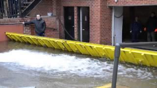
18 Armor, Adapt, Abandon Example of our Armor: Temporary door dams used at the U.S. Naval Academy as a flood preventive measure 18

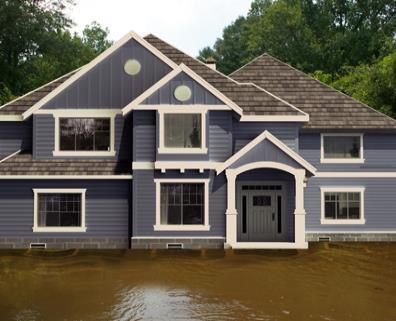
19 Should we adapt? More flood events due to Global SLR Flood damage costs exceed budgeted costs Can you afford not to adapt? Adaptation often costs less over time than flood damage Source: adaptationstories.com/2013/06/28/norfolk-rises-above-the-rising-tide/ 19
20 Height above first floor elevation Should we adapt? Replacement Cost = $1,000,000 5 ft 3 ft 1 ft 0 ft Damage Cost = $0 5 ft Flood Above MSL 10 ft 8 ft 6 ft 5 ft Height above MSL today MSL today 0 ft 20
21 Height above first floor elevation Should we adapt? Replacement Cost = $1,000,000 5 ft 3 ft 1 ft 0 ft Damage Cost = $400,000 7 ft Flood Above MSL 10 ft 8 ft 6 ft 5 ft Height above MSL today Equivalent to 5 ft Flood Above MSL After 2 ft of Sea Level Rise MSL today 0 ft 21

22 Height above first floor elevation Should we adapt? Replacement Cost = $1,000,000 5 ft 3 ft 1 ft 0 ft Damage Cost = $0 3 foot Protective Wall Around the Building 5 ft Flood Above MSL 10 ft 8 ft 6 ft 5 ft Height above MSL today MSL today 0 ft 22
23 Height above first floor elevation Should we adapt? Replacement Cost = $1,000,000 5 ft 3 ft 1 ft 0 ft Damage Cost = $0 3 foot Protective Wall Around the Building 7 ft Flood Above MSL 10 ft 8 ft 6 ft 5 ft Height above MSL today Equivalent to 5 ft Flood Above MSL After 2 ft of Sea Level Rise MSL today 0 ft 23


24 Adaptation Options Sources: - Oak Grove Lutheran School in Fargo, ND floodbreak.com/about/success-stories/success-story-kensington-gate-great-neck-ny 24

25 Adaptation Options Sources: smartvent.com, 25

26 Adaptation Options Sources: stormwater.wef.org/2014/03/first-full-scale-water-square-opens-rotterdam, 26
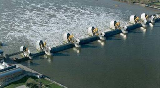
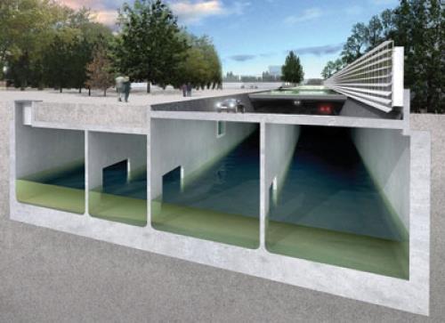
27 Adaptation Options Sources: cdn.londonreconnections.com/assets/thames_barrier_underspill_512.jpg 27

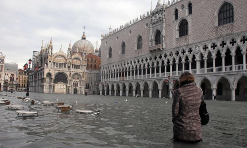
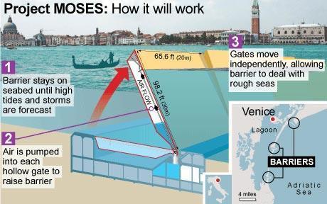
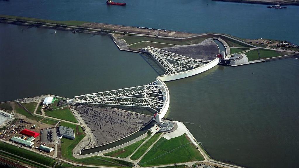
28 Adaptation Options Sources: ses-project-to-secure-future-of-venice.html 28


29 How does this affect my security? Sea level rise is felt by the Navy in Norfolk and Annapolis It s also felt by homeowners and businesses in Tampa Bay What can you do to protect your critical assets? Sources: wfla.com/2016/06/06/tropical-storm-colin-brings-flooding-to-st-pete-beach-pass-a-grille, 29


30 What can you do? Be informed about sea level rise and tell others Learn from other region s experiences Look for your vulnerabilities Take action, as needed, to Adapt, Armor, or Abandon Sources: wfla.com/2016/08/31/tracking-tropical-depression-9-hillsborough-county, 30
31 Questions? Angela Schedel, PhD, PE, Commander, U.S. Navy Ocean Engineering Dept, U.S. Naval Academy
32 References 2007 Stroeve et al. Arctic sea ice decline: Faster than forecast. Geophys. Res. Lett., 34, L onlinelibrary.wiley.com/doi/ /2007gl029703/full 2008 Hansen et al. Target atmospheric CO2: Where should humanity aim? Open Atmos. Sci. J., 2, pubs.giss.nasa.gov/abs/ha00410c.html 2008 Wanless, H. Statement on Sea Level in the Coming Century presentation. statement-on-sea-level.pdf 2013 IPCC 5 th Assessment Report National Climate Assessment. nca2014.globalchange.gov 2016 Hall et al. Regional Sea Level Scenarios for Coastal Risk Management. U.S. Department of Defense. Announcements/Program-News/DoD-Report-on-Regional-Sea-Level-Scenarios 32
Boothbay Harbor Rotary Club May 12, 2016
 Mapping Potential Sea Level Rise and Storm Surge in Boothbay Harbor, ME Boothbay Harbor Rotary Club May 12, 2016 Peter A. Slovinsky, Marine Geologist Maine Geological Survey S.M. Dickson, MGS Quickly,
SUPPLEMENTAL DOCUMENT SEA LEVEL RISE SCENARIO SELECTION AND DESIGN TIDE CALCULATION
 SUPPLEMENTAL DOCUMENT SEA LEVEL RISE SCENARIO SELECTION AND DESIGN TIDE CALCULATION FOR THE GUIDANCE FOR INCORPORATING SEA LEVEL RISE INTO CAPITAL PLANNING IN SAN FRANCISCO: ASSESSING VULNERABILITY AND
Sea Level Rise and Coastal Flooding Why Waves Matter!
 Sea Level Rise and Coastal Flooding Why Waves Matter! Jason D. Burtner Massachusetts Office of Coastal Zone Management South Shore Regional Coordinator Sea Level Rise and Coastal Storm Damage and Flooding
The Storm Surge Hazard 2018 TS-8 Tropical Meteorology 2
 The Storm Surge Hazard 2018 TS-8 Tropical Meteorology 2 Daniel Noah National Weather Service Tampa Bay daniel.noah@noaa.gov Tropical Cyclone Storm Surge Is a large dome of water, often 50 to 100 miles
City of Del Mar Local Coastal Plan (LCP) Amendment for Sea Level Rise and Coastal Flooding
 Amendment for Sea Level Rise and Coastal Flooding") City of Del Mar Local Coastal Plan (LCP) Amendment for Sea Level Rise and Coastal Flooding 6/22/17 Presentation to Sea Level Rise Stakeholder- Technical Advisory Committee (STAC) Nick Garrity, P.E. Lindsey
City of Del Mar Local Coastal Plan (LCP) Amendment for Sea Level Rise and Coastal Flooding 6/22/17 Presentation to Sea Level Rise Stakeholder- Technical Advisory Committee (STAC) Nick Garrity, P.E. Lindsey
U.S. Army Engineer Institute for Water Resources
 Sea Level Change Curve Calculator (2014.88) (DRAFT) U.S. Army Engineer Institute for Water Resources Table of Contents 1. INTRODUCTION... 2 1.1 BACKGROUND... 2 1.1.1 INFORMATION QUALITY ACT... 2 1.2 OVERVIEW...
APPENDIX D-2. Sea Level Rise Technical Memo
 APPENDIX D-2 Sea Level Rise Technical Memo 2185 N. California Blvd., Suite 500 Walnut Creek, CA 94596 (925) 944-5411 Fax: (925) 944-4732 www.moffattnichol.com DRAFT MEMORANDUM To: From: Neil Nichols,
Sea-level rise: How are we tracking in Wellington region & how will it effect coastal flooding? Dr Rob Bell NIWA, Hamilton
 Sea-level rise: How are we tracking in Wellington region & how will it effect coastal flooding? Dr Rob Bell NIWA, Hamilton Coastal adaptation in NZ: Starting-block issues with sea-level rise Tell us what
LOCAL COASTAL PROGRAM UPDATE
 LOCAL COASTAL PROGRAM UPDATE Agenda Meeting #1 General Information (1 1:45 pm) Introductions and Background Grants involved What is a Local Coastal Program? What is required? LCP Update tasks and schedule
Project Incorporation of Sea Level Rise City of Newport Beach Approach for Balboa Islands, City of Newport Beach, California
 Project Incorporation of Sea Level Rise City of Newport Beach Approach for Balboa Islands, City of Newport Beach, California Ying Poon, Everest International Consultants, Inc. CMANC Annual Winter Meeting
VENICE LOCAL COASTAL PROGRAM UPDATE: COASTAL HAZARDS WELCOME
 VENICE LOCAL COASTAL PROGRAM UPDATE: COASTAL HAZARDS WELCOME 1 Introducing the Team Hosted by the Department of City Planning and grant funded in part by the California Coastal Commission 2 Workshop Purpose
Leaning Into Adaptation
 www.marinslr.org Leaning Into Adaptation GFNMS Ocean Summit, May 17, 2016 Jack Liebster, Planning Manager, Marin County Marin County C-SMART Sea Level Rise Adaptation Process Evaluate Science Info. Implement
Sea Level Rise in South Florida: Causes, Consequences and Opportunities
 Sea Level Rise in South Florida: Causes, Consequences and Opportunities Dr. Todd A. Crowl Director, Institute of Water & the Environment Director, Southeast Environmental Research Center Co-Founder, Sea
New Orleans Municipal Yacht Harbor
 New Orleans Municipal Yacht Harbor Marina Schematic Design Update 601 Poydras St., Suite 1860 New Orleans, LA, 70130 504-648-3560 Post-Katrina Municipal Yacht Harbor: Introduction The MYH was an approximate
Assessment of flooding on low-elevation reef-lined coasts
 Assessment of flooding on low-elevation reef-lined coasts Ap van Dongeren, Deltares, Delft, The Netherlands With Curt Storlazzi, USGS, Santa Cruz, USA Impact on coral reef-lined islands and coasts Coral
Coastal Inundation. An Overview for TCDC
 Coastal Inundation An Overview for TCDC Rick Liefting Team Leader Regional Hazards and Environmental Compliance Integrated Catchment Management Waikato Regional Council Photo: Sugar Loaf Wharf, Coromandel.
Introduction to Storm Surge
 Introduction to Storm Surge Hurricane Katrina (2005) Mississippi 1200 deaths, $108 billion damage Hurricane Sandy (2012) Northeast U.S. 73 deaths, $65 billion damage Hurricane Ike (2008) - Bolivar Peninsula,
Coastal Hazards Study
 Coastal Hazards Study 2212 Beach Boulevard, Pacifica Prepared for: EXECUTIVE SUMMARY City of Pacifica 170 Santa Maria Ave Pacifica, CA 94044 Prepared by: moffatt & nichol 2185 N. California Blvd. Walnut
Beach Nourishment as a Management Tool to Adapt to Sea Level Rise
 Beach Nourishment as a Management Tool to Adapt to Sea Level Rise Jim Houston and Bob Dean Shore and Beach (2016) and Coastal Engineering (2016) Future of Florida s Beaches Should we look to the future
FEMA West Coast Sea Level Rise Pilot Study
 FEMA West Coast Sea Level Rise Pilot Study Ed Curtis, P.E., CFM FEMA Region IX June 4, 2014 Presentation Objectives Present the goals of the FEMA West Coast Sea Level Rise Pilot Study Review the SLR Pilot
Collaboration: Sea-level Marin Adaptation Response Team (C-SMART)
") Collaboration: Sea-level Marin Adaptation Response Team (C-SMART) Photo Credit : Lighthawk Aerial Community Development Agency 3501 Civic Center Drive, Rm. 308 San Rafael, CA 94903 415 4736269 T www.marinslr.org
Collaboration: Sea-level Marin Adaptation Response Team (C-SMART) Photo Credit : Lighthawk Aerial Community Development Agency 3501 Civic Center Drive, Rm. 308 San Rafael, CA 94903 415 4736269 T www.marinslr.org
El Niño: what it is and what to expect in San Francisco Bay
 El Niño: what it is and what to expect in San Francisco Bay A. O Neill U.S. Geological Survey Pacific Coastal and Marine Science Center Santa Cruz Outline Tropical Ocean and El Niño Impacts beyond the
Coastal Adaptation to Sea level Rise Patrick Cunningham
 Coastal Adaptation to Sea level Rise Patrick Cunningham 1 Table of Contents The COAST Team Blue Marble and COAST The COAST Approach Example Projects North Hampton, NH/ Portland, ME Ideas for Maine Municipalities
Hydrologic Feasibility of Storm Surge Barriers
 Hydrologic Feasibility of Storm Surge Barriers Malcolm J. Bowman, School of Marine and Atmospheric Sciences State University of New York, Stony Brook, NY. Presented at Against the Deluge: Storm Surge Barriers
Effectiveness of Beach Nourishment in Response to Sea Level Rise
 2014 FSBPA Annual Conference Effectiveness of Beach Nourishment in Response to Sea Level Rise Navarre Beach Santa Rosa County July 18, 2005 Lovers Key Lee County April 23, 2012 South County St. Lucie County
THE ATMOSPHERE. WEATHER and CLIMATE. The Atmosphere 10/12/2018 R E M I N D E R S. PART II: People and their. weather. climate?
 R E M I N D E R S Two required essays are due by Oct. 30, 2018. (A third may be used for extra credit in place of a Think Geographically essay.) ESSAY TOPICS (choose any two): Contributions of a noted
Tsunamis. Tsunamis COMMUNITY EMERGENCY RESPONSE TEAM TSUNAMIS
 Tsunamis Tsunamis Tell the participants that tsunamis are ocean waves that are produced by underwater earthquakes or landslides. The word is Japanese and means harbor wave because of the devastating effects
Physical Geography. Physical Geography III of the United States and Canada. Formation of Great Lakes. Climates of North America. Definitions 2/21/2013
 Physical Geography III of the United States and Canada Ancient Glacial Lakes As the Ice Age ended, areas of North America beyond the terminal moraine were flooded with melt water Prof Anthony Grande AFG
Case Studies Georg Umgiesser and Natalja Čerkasova KU, Lithuania
 Case Studies Georg Umgiesser and Natalja Čerkasova KU, Lithuania Case 1: A beach in the Curonian Lagoon 1 Beach Current situation in Curonian lagoon Beach in Kintai In the past, especially in Baltic inner
Unit 11 Lesson 2 How Does Ocean Water Move? Copyright Houghton Mifflin Harcourt Publishing Company
 Unit 11 Lesson 2 How Does Ocean Water Move? Catch a Wave A wave is the up-and-down movement of surface water. Catch a Wave Catch a Wave (wave effects) Surface waves are caused by wind pushing against
The Wave Climate of Ireland: From Averages to Extremes. Sarah Gallagher, Met Éireann
 The Wave Climate of Ireland: From Averages to Extremes Sarah Gallagher, Met Éireann IMS One Day Conference: The Perfect Storm, 28th March 2015 Motivation & Introduction Methodology - How can we Model Waves?
SURGE SUPPRESSION ACHIEVED BY DIFFERENT COASTAL SPINE (IKE DIKE) ALIGNMENTS. Bruce A. Ebersole, Thomas W. Richardson and Robert W.
 ALIGNMENTS. Bruce A. Ebersole, Thomas W. Richardson and Robert W.") SURGE SUPPRESSION ACHIEVED BY DIFFERENT COASTAL SPINE (IKE DIKE) ALIGNMENTS Abstract Bruce A. Ebersole, Thomas W. Richardson and Robert W. Whalin, Jackson State University, Jackson, Mississippi The primary
SURGE SUPPRESSION ACHIEVED BY DIFFERENT COASTAL SPINE (IKE DIKE) ALIGNMENTS Abstract Bruce A. Ebersole, Thomas W. Richardson and Robert W. Whalin, Jackson State University, Jackson, Mississippi The primary
OCN 201: Coastal Erosion and Beach Loss
 OCN 201: Coastal Erosion and Beach Loss This lecture was prepared from slides and notes kindly provided by: Prof. Chip Fletcher Department of Geology and Geophysics, University of Hawaii Chip Fletcher
Ocean Circulation, Food Webs and Climate What does the wind have to do with feeding fish (and feeding us)?
?") Ocean Circulation, Food Webs and Climate What does the wind have to do with feeding fish (and feeding us)? El Niño: Tropical Oceans and Global Climate Reading: 9.10-9.13, 9.15 Graphic: Upwelling off Cape
Ocean Circulation, Food Webs and Climate What does the wind have to do with feeding fish (and feeding us)? El Niño: Tropical Oceans and Global Climate Reading: 9.10-9.13, 9.15 Graphic: Upwelling off Cape
North Shore of Long Island, Feasibility Study
 North Shore of Long Island, Asharoken New York Asharoken, Feasibility Study Asharoken, NY Public Meeting June 30, 2015 US Army Corps of Engineers US Army Corps of Engineers New York BUILDING STRONG BUILDING
4/20/17. #31 - Coastal Erosion. Coastal Erosion - Overview
 Writing Assignment Due Monday by 11:59 pm #31 - Coastal Erosion Beach front property! Great View! Buy now at a great price! See main class web pages for detailed instructions Essays will be submitted in
Australian Coastal Councils Conference
 Australian Coastal Councils Conference Kiama March 2019 Where Has My Beach Gone? (and what can I do about it?) Dr Andrew McCowan Water Technology Where Has My Beach Gone? Where Has My Beach Gone? Where
Sea-Level Rise and Coastal Habitats in Southeastern Louisiana An Application of the SLAMM Model
 Sea-Level Rise and Coastal Habitats in Southeastern Louisiana An Application of the SLAMM Model Patty Glick (National Wildlife Federation) Jonathan Clough (Warren Pinnacle Consulting, Inc.) Amy Polaczyk
Tracking Marsh Elevation and Water Levels in Elkhorn Slough January 2017
 Tracking Marsh Elevation and Water Levels in Elkhorn Slough January 2017 1931 Charlie Endris GIS Specialist Elkhorn Slough NERR Elkhorn Slough Foundation Central Coast Wetlands Group 2015 Questions Are
NYS Coastal Waters. Water Resources of NYS: THE NATURE of the COASTAL ZONE. NYS Coastal Waters. NYS Coastal Atlas. Coastal Zone Management 10/10/2014
 Water Resources of NYS: THE NATURE of the COASTAL ZONE NYS Coastal Waters NYS is the only state to border the Atlantic Ocean and the Great Lakes (Lakes Erie and Ontario). Great Lakes shoreline: 577 miles
Weather EOG Review Questions
 Weather EOG Review Questions 1. Which statement best describes runoff? A Water vapor cools off and changes into water droplets. B Water in the form of rain, snow, sleet, or hail falls from clouds. C Precipitation
DAILY FLOOD SHEET (Imperial) Manitoba Lakes Highest Recorded Peak Flood
 Manitoba Lakes Highest Recorded Peak Flood") Hydrologic Forecasting and Water Management, Infrastructure & Transportation August 1, 2014 LOCATION Today's Change from (ft) of Forecasted eak DAILY FLOOD SHEET (Imperial) s est Recorded eak Flood Desirable
Hydrologic Forecasting and Water Management, Infrastructure & Transportation August 1, 2014 LOCATION Today's Change from (ft) of Forecasted eak DAILY FLOOD SHEET (Imperial) s est Recorded eak Flood Desirable
Case Studies. Georg Umgiesser and Natalja Čerkasova KU, Lithuania
 Case Studies Georg Umgiesser and Natalja Čerkasova KU, Lithuania Case 1: A beach in the Curonian Lagoon Beach Current situation in Curonian lagoon Beach in Kintai In the past, especially in Baltic inner
Image courtesy of NASA/GSFC
 Image courtesy of NASA/GSFC Impact of Weather Extremes and Climate Change on Midwest Agriculture Eugene S. Takle Professor Department of Agronomy Department of Geological and Atmospheric Science Director,
ENSO and monsoon induced sea level changes and their impacts along the Indian coastline
 Indian Journal of Marine Sciences Vol. 35(2), June 2006, pp. 87-92 ENSO and monsoon induced sea level changes and their impacts along the Indian coastline O.P.Singh* Monsoon Activity Centre, India Meteorological
Ivan-like hurricane storm surge simulations for Tampa Bay, FL with 3-D and 2-D models
 Ivan-like hurricane storm surge simulations for Tampa Bay, FL with 3-D and 2-D models R.H. Weisberg and L. Zheng Storm Surge Workshop St. Pete Beach 2/11/09 Potential for Tampa Bay area inundation is large
Atmospheric Circulation. Recall Vertical Circulation
 Today s topics: Atmospheric circulation: generation of wind patterns on a rotating Earth Seasonal patterns of climate: Monsoons and Sea Breezes Tropical Cyclones: Hurricanes and typhoons Atmospheric Circulation
The Ike Dike. A Coastal Barrier Protecting the. Hurricane Storm Surge. Protecting the Houston/Galveston Region from Hurricane Storm Surge
 The Ike Dike A Coastal Barrier Protecting the Houston/Galveston A Coastal Barrier Region from Hurricane Storm Surge Protecting the Houston/Galveston Region from Hurricane Storm Surge The Houston/Galveston
consulting engineers and scientists
 consulting engineers and scientists Coastal Processes Presented by: January 9, 2015 Varoujan Hagopian, P.E. F.ASCE Senior Consultant, Waterfront Engineer Living Shoreline Workshop Lets Remember Why We
Bob Battalio, PE Chief Engineer, ESA September 8, 2016
 RELATING FUTURE COASTAL CONDITIONS TO EXISTING FEMA FLOOD HAZARD MAPS Technical Methods Manual Bob Battalio, PE Chief Engineer, ESA September 8, 2016 FMA 2016 Sacramento, California DWR-OST-SIO PILOTING
STATUS REPORT FOR THE SUBMERGED REEF BALL TM ARTIFICIAL REEF SUBMERGED BREAKWATER BEACH STABILIZATION PROJECT FOR THE GRAND CAYMAN MARRIOTT HOTEL
 August 23 STATUS REPORT FOR THE SUBMERGED REEF BALL TM ARTIFICIAL REEF SUBMERGED BREAKWATER BEACH STABILIZATION PROJECT FOR THE GRAND CAYMAN MARRIOTT HOTEL performed by Lee E. Harris, Ph.D., P.E. Consulting
Coastal Erosion Impact on Rincón Infrastructure
 Lessons Learned and Best Practices: Resilience of Coastal Infrastructure Coastal Erosion Impact on Rincón Infrastructure Luis D. Aponte, Ph.D. P.E. luisd.aponte@upr.edu Professor University of Puerto Rico
Synoptic Lab, MET 421, Test 2
 Name Synoptic Lab, MET 421, Test 2 1) For a 15 ms -1 east wind blowing towards Milwaukee a) Calculate the distance to the east shore of Lake Michigan. You can use a distance calculator website such as
Influence of oceanographic processes on coastal erosion, morphology and inundation
 FACULTY OF ENGINEERING, COMPUTING AND MATHEMATICS Influence of oceanographic processes on coastal erosion, morphology and inundation Charitha Pattiaratchi School of Civil, Environmental and Mining Engineering
SAN MATEO COUNTY SEA LEVEL RISE INITIATIVE
 SAN MATEO COUNTY SEA LEVEL RISE INITIATIVE OCEAN CLIMATE SUMMIT // MAY 17, 2016 Photo by Biking Nikon SF, all rights reserved San Mateo County has $24 billion in assets at risk from sea level rise Pacifica
The Movement of Ocean Water. Currents
 The Movement of Ocean Water Currents Ocean Current movement of ocean water that follows a regular pattern influenced by: weather Earth s rotation position of continents Surface current horizontal movement
Sussex County, DE Preliminary Study Overview
 Sussex County, DE Preliminary Study Overview Coastal study scope: 102 miles of entire County shoreline Revised 102 panels for coastal study Riverine study scope: 14 streams, 67.1 miles, within the Nanticoke
What are we adapting to? David Provis Senior Principal, Oceanography, Cardno Member, Victorian Coastal Council
 What are we adapting to? David Provis Senior Principal, Oceanography, Cardno Member, Victorian Coastal Council Sea-level -NOAA Sea-level - NOAA 90% probability ranges Sea-level - NOAA Sea-level Port Phillip
Coastal management has lagged behind the growth in population leading to problems with pollution
 Fifty percent of the population of the industrialized world lives within 100 km of a coast. Coastal management has lagged behind the growth in population leading to problems with pollution and natural
A Rapid Assessment of Kili Island, Republic of the Marshall Islands, Following January 2011 Coastal Inundation: Implications for Future Vulnerability
 A Rapid Assessment of Kili Island, Republic of the Marshall Islands, Following January 2011 Coastal Inundation: Implications for Future Vulnerability Table of Contents Executive Summary Kili Objectives
Air Temperature, Melting Ice and Disappearing Land
 Air Temperature, Melting Ice and Disappearing Land Climate scientists study changes in icebergs and glaciers. Glaciers are massive sheets of ice that cover the land in places like Greenland in the Arctic
A Snapshot of Our Changing Climatology
 A Snapshot of Our Changing Climatology Dr. Kenneth ( Kenny ) Blumenfeld Sr. Climatologist DNR State Climatology Office 11/17/2018 1 Items to bear in mind 1. Climate news elsewhere may not apply here 2.
Innovative Technologies for a Resilient Marine Transportation System
 Innovative Technologies for a Resilient Marine Transportation System Transportation Research Board MG John Peabody, P.E. Deputy Commanding General for Civil and Emergency Operations, U.S. Army Corps of
Figure 1, Chart showing the location of the Breach at Old Inlet and sensors deployed in Great South Bay.
 The Impact on Great South Bay of the Breach at Old Inlet Charles N. Flagg and Roger Flood School of Marine and Atmospheric Sciences, Stony Brook University The Great South Bay project (http://po.msrc.sunysb.edu/gsb/)
LAKKOPETRA (GREECE) EUROSION Case Study. Contact: Kyriakos SPYROPOULOS. TRITON Consulting Engineers. 90 Pratinou Str Athens (GREECE)
 EUROSION Case Study. Contact: Kyriakos SPYROPOULOS. TRITON Consulting Engineers. 90 Pratinou Str Athens (GREECE)") LAKKOPETRA (GREECE) Contact: Kyriakos SPYROPOULOS TRITON Consulting Engineers 90 Pratinou Str. 11634 Athens (GREECE) Tel: +32 10 729 57 61 Fax: +32 10 724 33 58 e-mail: kspyropoulos@tritonsa.gr 19 1 1.
LAKKOPETRA (GREECE) Contact: Kyriakos SPYROPOULOS TRITON Consulting Engineers 90 Pratinou Str. 11634 Athens (GREECE) Tel: +32 10 729 57 61 Fax: +32 10 724 33 58 e-mail: kspyropoulos@tritonsa.gr 19 1 1.
3/9/2013. Build house on cliff for a view of the ocean - be one with said view Pearson Education, Inc. Shorelines: summary in haiku form
 Introduction to Environmental Geology, 5e Edward A. Keller Shorelines: summary in haiku form Chapter 11 Coastal Processes Lecture Presentation prepared by X. Mara Chen, Salisbury University Build house
First of all, you should know that weather and climate are not the same thing.
 First of all, you should know that weather and climate are not the same thing. WEATHER IS: Short term Limited area Can change rapidly Difficult to predict WEATHER is what s happening outside your window
Impact of Climate Change on Dutchess County
 Impact of Climate Change on Dutchess County Vicky Kelly Cary Institute of Ecosystem Studies Marist College Center for Lifetime Study The Impact of the Hudson River on American History and Culture October
Municipal Adaptation to Sea Level Rise in Saco Bay, Ogunquit, and Seabrook
 Municipal Adaptation to Sea Level Rise in Saco Bay, Ogunquit, and Seabrook Changing Environments Symposium Bowdoin College October 24, 2009 Climate Change Adaptation Panel 1:45 to 3:00 PM Jonathan T. Lockman,
ALTERNATIVES FOR COASTAL STORM DAMAGE MITIGATION AND FUNCTIONAL DESIGN OF COASTAL STRUCTURES
 The University of the West Indies Organization of American States PROFESSIONAL DEVELOPMENT PROGRAMME: COASTAL INFRASTRUCTURE DESIGN, CONSTRUCTION AND MAINTENANCE A COURSE IN COASTAL DEFENSE SYSTEMS I CHAPTER
Water Budget I: Precipitation Inputs
 Water Budget I: Precipitation Inputs Forest Cover Global Mean Annual Precipitation (MAP) Biomes and Rainfall Forests won t grow where P < 15 / yr Forest type depends strongly on rainfall quantity, type
Name: Date: Day/Period: CGC1P1: Interactions in the Physical Environment. Factors that Affect Climate
 Name: Date: Day/Period: CGC1P1: Interactions in the Physical Environment PART A: Weather and Climate Factors that Affect Climate 1. The words weather and climate are often incorrectly used interchangeably.
Figure 1 GE image of the Costa Sur & EcoEléctrica power plants, located inside Guayanilla and Tallaboa bay.
 1 7 - STORM SURGES IN PUERTO RICO_Power Plants-Costa Sur & EcoElectrica Costa Sur & EcoEléctrica Figure 1 shows a GE image of the Costa Sur (Guayanilla) and EcoElectrica site. Figure 2 shows the topographic
2016 NC Coastal Local Governments Annual Meeting
 2016 NC Coastal Local Governments Annual Meeting Coastal Flood Study Modeling and Mapping 101 April 21, 2016 Tom Langan, PE, CFM Engineering Supervisor NCEM Floodplain Mapping Program FEMA Coastal Flood
3/22/11. General Circulation of the Atmosphere. General Circulation of the Atmosphere
 Chapter 10 General refers to the average air flow, actual winds will vary considerably. Average conditions help identify driving forces. The basic cause of the general circulation is unequal heating of
GONE! Coastal Erosion Happens During Storms! Why Worry About Coastal Setbacks? Goals for Today
 RI Regulatory Setbacks & Buffers: Coastal Zone Management Issues New England Onsite Wastewater Training Program @ URI OWT 155 November 21, 2013 Goals for Today Understand the impacts of storms, coastal
Atmospheric Circulation. Density of Air. Density of Air: H 2 O and Pressure effects
 Today s topics: Atmospheric circulation: generation of wind patterns on a rotating Earth Seasonal patterns of climate: Monsoons and Sea Breezes Tropical Cyclones: Hurricanes and typhoons Atmospheric Circulation
Hydrodynamic and hydrological modelling to support the operation and design of sea ports
 Hydrodynamic and hydrological modelling to support the operation and design of sea ports Data needs and examples Martijn de Jong (port/nautical requirements, waves, currents) Sofia Caires (mean and extreme
COASTAL TOURISM TESTED BY CLIMATE CHANGE. by Pearl Macek. Aerial photographs by John Supancic
 COASTAL TOURISM TESTED BY CLIMATE CHANGE by Pearl Macek Aerial photographs by John Supancic 28 41 N winter 2017 FOCUS ON WATER A fish ladder was constructed at Horseshoe Falls Dam in the Pawcatuck River
METEOROLOGY OF FAIRBANKS WINTER: MAKING SENSE OF THAT CRAZY INVERSION
 METEOROLOGY OF FAIRBANKS WINTER: MAKING SENSE OF THAT CRAZY INVERSION Rick Thoman Climate Science and Services Manager National Weather Service Alaska Region What s an inversion and why should I care?
Decision Support Briefing 1 As of: 945AM EDT 8/28/2017. Wakefield, VA. What Has Changed?
 Decision Support Briefing 1 As of: 945AM EDT 8/28/2017 http://www.weather.gov/akq/--- What Has Changed? Initial Issuance Main Points Hazard Impacts Location Timing Wind Damage to weak structures, trees
North Half Moon Bay Shoreline Improvement Project, Pillar Point Harbor, CA Coastal Engineering Appendix
 Engineer Research & Development Center / San Francisco District U. S. Army Corps of Engineers North Half Moon Bay Shoreline Improvement Project, Pillar Point Harbor, CA Coastal Engineering Appendix Photograph
Equatorial upwelling. Example of regional winds of small scale
 Example of regional winds of small scale Sea and land breezes Note on Fig. 8.11. Shows the case for southern hemisphere! Coastal upwelling and downwelling. Upwelling is caused by along shore winds, that
CALCASIEU SALINITY STRUCTURES. HYDRODYNAMIC MODELING (To Support Design of Salinity Barriers)
") CALCASIEU SALINITY STRUCTURES HYDRODYNAMIC MODELING (To Support Design of Salinity Barriers) Presentation Overview 1 2 3 4 5 Project Overview and CEA Circulation Modeling Vessel Hydrodynamics Modeling
CALCASIEU SALINITY STRUCTURES HYDRODYNAMIC MODELING (To Support Design of Salinity Barriers) Presentation Overview 1 2 3 4 5 Project Overview and CEA Circulation Modeling Vessel Hydrodynamics Modeling
Tides. Tides: longest waves. or seas. or ripples
 Tides or ripples or seas Tides: longest waves Tides Definition: The rise and fall of sea level due to the gravitational forces of the Moon and Sun and the rotation of the Earth. Why tides are important?
Land use changes and their impacts on extreme events. By Millán M. Millán
 Land use changes and their impacts on extreme events By Millán M. Millán Conference: Land as a Resource, Brussels 19 June 2014 Atlantic Fronts 20% Decreasing Summer Storms 15% Decreasing Gone Mediterranean
Taranaki Tsunami Inundation Analysis. Prepared for Taranaki Civil Defence Emergency Management Group. Final Version
 Taranaki Tsunami Inundation Analysis Prepared for Taranaki Civil Defence Emergency Management Group Final Version June 2012 AM 12/07 HBRC Plan Number 4362 Asset Management Group Technical Report Prepared
Name Class Date. Use the terms from the following list to complete the sentences below. Each term may be used only once. Some terms may not be used.
 Assessment Chapter Test B The Movement of Ocean Water USING KEY TERMS Use the terms from the following list to complete the sentences below. Each term may be used only once. Some terms may not be used.
SEA LEVEL RISE IMPACT ASSESSMENT AND MITIGATION ALTERNATIVES DEVELOPMENT FOR BALBOA ISLANDS, CITY OF NEWPORT BEACH, CALIFORNIA
 SEA LEVEL RISE IMPACT ASSESSMENT AND MITIGATION ALTERNATIVES DEVELOPMENT FOR BALBOA ISLANDS, CITY OF NEWPORT BEACH, CALIFORNIA Ying Poon 1, Brett Sanders 2, Randy Mason 3 and Robert Stein 4 The City of
Today: Coastal Issues and Estuaries
 Today: Coastal Issues and Estuaries Coastal issues Human effect on coastlines What is an estuary Why are they so important? Circulation of water in estuary Environmental issues Coastal Issues: Problem
El Nino and Global Warming
 El Nino and Global Warming El Niño and Global Warming El Niño Climate Trade winds Barometric pressure Southern oscillation WHAT YOU WILL LEARN 1. You will identify the cause of El Niño events. 2. You will
Recent Atmospheric and Oceanic Circulation Changes Affecting Winter Weather in North America. Dr. Art Douglas Professor Emeritus Creighton University
 Recent Atmospheric and Oceanic Circulation Changes Affecting Winter Weather in North America Dr. Art Douglas Professor Emeritus Creighton University Outline 1. The 2018 El Nino: A Northern Hemisphere induced
Town of Duck, North Carolina
 Tracking No. 00.00.2010 Erosion Mitigation And Shoreline Management Feasibility Study Town of Duck, North Carolina Coastal Planning & Engineering of North Carolina August 15, 2012 Tom Jarrett Robert Neal
Nature Of Marine winds, Waves and Swells over West African Coasts Case study of Victoria Island beach in Lagos, Nigeria
 Nature Of Marine winds, Waves and Swells over West African Coasts Case study of Victoria Island beach in Lagos, Nigeria By S. O. Gbuyiro and E. Olaniyan Marine Unit, Nigeria Meteorological Agency, Lagos
Water on Earth. How do oceans relate to weather and the atmosphere? Solar Radiation and Convection Currents
 Earth is often called the Blue Planet because so much of its surface (about 71%) is covered by water. Of all the water on Earth, about 96.5% is held in the world s oceans. As you can imagine, these oceans
Higher than a Sea-Bird's Eye View: Coral Reef Remote Sensing Using Satellites
 LIVE INTERACTIVE LEARNING @ YOUR DESKTOP Higher than a Sea-Bird's Eye View: Coral Reef Remote Sensing Using Satellites Presented by Mark Eakin Coordinator, NOAA Coral Reef Watch Tuesday, December 15, 2009
SACO RIVER AND CAMP ELLIS BEACH SACO, MAINE SECTION 111 SHORE DAMAGE MITIGATION PROJECT APPENDIX F ECONOMIC ASSESSMENT
 SACO RIVER AND CAMP ELLIS BEACH SACO, MAINE SECTION 111 SHORE DAMAGE MITIGATION PROJECT APPENDIX F ECONOMIC ASSESSMENT Department of the Army New England District, Corps of Engineers 696 Virginia Road
Jeopardy Q $100 Q $100 Q $100 Q $100 Q $100 Q $200 Q $200 Q $200 Q $200 Q $200 Q $300 Q $300 Q $300 Q $300 Q $300 Q $400 Q $400 Q $400 Q $400 Q $400
 Jeopardy Grab Bag Review Grab Bag Review 2 Biomes Climate Factors that affect climate Q $100 Q $200 Q $300 Q $400 Q $500 Q $100 Q $100 Q $100 Q $100 Q $200 Q $200 Q $200 Q $200 Q $300 Q $300 Q $300 Q $300
ST LEONARDS COASTAL HAZARD VULNERABILITY ASSESSMENT
 Level 12, 333 Collins Street Melbourne VIC 3000 Australia Telephone: +61 3 8676 3500 Facsimile: +61 3 8676 3505 www.worleyparsons.com WorleyParsons Services Pty Ltd ABN 61 001 279 812 23 November 2011
Adaptation of Transport Networks to Climate Change Alexandroupolis, Greece June Capt L.B Barbeau Port Master Mauritius Ports Authority
 Adaptation of Transport Networks to Climate Change Alexandroupolis, Greece 25-26 June 2012 Capt L.B Barbeau Port Master Mauritius Ports Authority Sensitivity of Port Louis Harbour 1. Strategically located