Digital Elevation Models
|
|
|
- Hugh Hines
- 5 years ago
- Views:
Transcription


1 Digital Elevation Models National Elevation Dataset 14-Oct-14 GEO327G/386G, UT Austin 1
2 Data Sets US DEM series 7.5, 30, 1 o for conterminous US 7.5, 15 for Alaska US National Elevation Data (NED) GTOPO30 Global Land One-kilometer Base Elevation (GLOBE) ETOPO2 Shuttle Radar Topographic Mission (SRTM) Advanced Spaceborne Thermal Emission and Reflection Radiometer (ASTER) LIDAR data (TNRIS and other sources) Custom models from stereo photo pairs - photogrammetry 14-Oct-14 GEO327G/386G, UT Austin 2


3 US 1 o DEMs ~90 meter resolution WGS72 or WGS84 datum Decimal seconds (!) in older.dem format Elev. in meters Obtain via FTP 14-Oct-14 GEO327G/386G, UT Austin 3

4 NAD83 (or NAD 27) Resolution 30 (or 10) meters UTM projections Entire US available US 7.5 DEMs 1:130,00 as captured 14-Oct-14 GEO327G/386G, UT Austin 4

5 Data Sets US 7.5 DEMs: detailed view 1:50,000 as captured 14-Oct-14 GEO327G/386G, UT Austin 5

6 Data Sets US 7.5 DEMs: at 1:24,000 1:50,000 as captured 14-Oct-14 GEO327G/386G, UT Austin 6

7 US National Elevation Data (NED) Seamless data set for US and territories 1 Arc Second (30 m) resolution NAD83, decimal degrees Distribution very slick Available in Arc.grd format 14-Oct-14 GEO327G/386G, UT Austin 7
8 GTOPO30 USGS Global 30-Arc Second DEM Completed 1996 Horizontal grid spacing ~ 1 km 21,600 rows x 43,200 columns WGS84 and sea level datums Data are in decimal degrees and meters above S.L. 14-Oct-14 GEO327G/386G, UT Austin 8

9 GTOPO30 30 o x 50 o Data Tiles, EROS Data Center or via FTP 14-Oct-14 GEO327G/386G, UT Austin 9
10 GTOPO30 in ArcMap Load in band-interleaved-by-line (.bil) format Convert.bil to.grd (Spatial Analyst) -16 bit binary integer data converted to ASCII Use map calculator to restore negative values and convert 9999 (no data) cells to null. Details are available 14-Oct-14 GEO327G/386G, UT Austin 10

11 GTOPO30 tiles in ArcMap 1:10,000,000 (as captured) 100 meter classes 14-Oct-14 GEO327G/386G, UT Austin 11


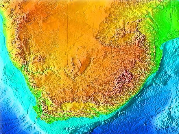
12 GTOPO30 resolution: S. Africa 1:2,000,000 1:1,000, Oct-14 GEO327G/386G, UT Austin 12

13 The Global Land One-km Base Elevation G.L.O.B.E. NOAA data 14-Oct-14 GEO327G/386G, UT Austin 13
14 The Global Land One-km Base Elevation GLOBE 1 completed o x 45 o tiles WGS84, decimal degrees Import in ArcMap exactly like GTOPO30 14-Oct-14 GEO327G/386G, UT Austin 14

15 ETOPO2 NOAA global relief (land & oceans) Gridded at 2 minute resolution (~4 km): columns x 5400 rows Subsets can be extracted from CD in a variety of formats 14-Oct-14 GEO327G/386G, UT Austin 15

16 ETOPO2 14-Oct-14 GEO327G/386G, UT Austin 16

17 ETOPO2 14-Oct-14 GEO327G/386G, UT Austin 17


18 Shuttle RadarTopographic Mission 10-day mission in Feb to map earth s topography at 30 m x, y resolution and ~ 16 m in z Topography derived from radar interferometry Best global data set to date Images courtesy of NASA interferogram 14-Oct-14 GEO327G/386G, UT Austin 18


19 SRTM Coverage ~ 60 o N to 56 o S latitude ~ 80% of land surface Only uniform global elevation dataset Images courtesy of NASA 14-Oct-14 GEO327G/386G, UT Austin 19
20 SRTM Data Availability 1-arc second (30 meter) SRTM data of the continental US available via the USGS EDC Seamless Distribution System Up to 30 degree squares of raster data (1.6 gigabytes), in 100 megabyte sized files, can be downloaded at no charge. As new 3-arc second (~90 meter) international continental datasets are available, USGS will distribute via the Seamless Data Distribution System - Enhanced. Higher resolution (30 meter) international data are available via special request (?) 14-Oct-14 GEO327G/386G, UT Austin 20
21 ASTER DEMs Advanced Spaceborn Thermal Emission and Reflection Radiometer Used for surface temperature, reflectance and elevation See ASTER data site for details 30 meter resolution DEMs are available for registered users (i.e. GDEM) global data set! If not GDEM then data conversion for individual tiles to ArcInfo is required 14-Oct-14 GEO327G/386G, UT Austin 21
22 ASTER GDEM Global 30 meter postings! 14-Oct-14 GEO327G/386G, UT Austin 22


23 Single ASTER Tile Example Lascar volcano, Chile 14-Oct-14 GEO327G/386G, UT Austin 23

 LIDAR 14-Oct-14 GEO327G/386G,")
24 LIDAR LIght Detection And Ranging = Laser Radar : two-way ranging technique using a laser scanner Airborne LIDAR Scanning (Ground-based) LIDAR 14-Oct-14 GEO327G/386G, UT Austin 24

25 Airborne LIDAR From Gibeaut, Oct-14 GEO327G/386G, UT Austin 25
 LIDAR unit in a Cesna 206 14-Oct-14 GEO327G/386G, UT")
26 Airborne LIDAR Requires Precise positioning for aircraft (DGPS ground and air) Laser ranges & scan angles Platform position (yaw, pitch, roll of aircraft) Produces Swaths 100 s meters wide Accuracy of 1-4 cm in x,y,z A Laser head B Control rack BEG s (old) LIDAR unit in a Cesna Oct-14 GEO327G/386G, UT Austin 26


27 Matagorda Island LIDAR Contour interval = 25 cm! From Gibeaut, Oct-14 GEO327G/386G, UT Austin 27
 to Multipoint feature class 2.")
 hillshade of DEM")
28 Airborne LIDAR in ArcGIS 1. Convert LAS file(s) to Multipoint feature class 2. Use Multipoint to create a TIN Terrain 3. Covert TIN to DEM Terrain Model (TIN) hillshade of DEM (raster) 14-Oct-14 GEO327G/386G, UT Austin 28

")
29 Application: Airborne LIDAR slope mapping Mapping of geologic units and faults by changes in slope, e.g. central Texas hill country Slope Map hillshade of DEM (raster) Cretaceous Glen Rose and Walnut Formations (carbonate rocks) 14-Oct-14 GEO327G/386G, UT Austin 29


30 Terrestrial LIDAR Rapid, quantitative characterization of outcrops 2,000 pts/sec, mins/scan Point clouds rendered with software 14-Oct-14 GEO327G/386G, UT Austin From Belian et al.,

31 360 o Cave Image From Gary 14-Oct-14 GEO327G/386G, UT Austin 31

32 Terrestrial LIDAR Applications From Belian et al., Oct GEO327G/386G, UT Austin


33 Scanning Lidar on robotic rover 14-Oct-14 GEO327G/386G, UT Austin 33

 and")


34 Custom Photogrammetry Unmanned Aerial Vehicles (UAVs) and photogrammetry software 274 stitched UAV images Google Earth image 14-Oct-14 GEO327G/386G, UT Austin 34

35 Custom Photogrammetry SfM = Structure from Motion = photogrammetry From Fonstad et al., stitched UAV images 14-Oct-14 GEO327G/386G, UT Austin 35
Utilizing Vessel Based Mobile LiDAR & Bathymetry Survey Techniques for Survey of Four Southern California Breakwaters
 Utilizing Vessel Based Mobile LiDAR & Bathymetry Survey Techniques for Survey of Four Southern California Breakwaters Western Dredging Association: Pacific Chapter September 2012 Insert: Pipe Location
Airborne Remote Sensing of Surface and Internal Wave Processes on the Inner Shelf
 Airborne Remote Sensing of Surface and Internal Wave Processes on the Inner Shelf Ken Melville, Luc Lenain Scripps Institution of Oceanography North Wind/Wave NDBC Station 42040 29.212 N 88.207 W 19 Oct
Challenges in determining water surface in airborne LiDAR topobathymetry. Amar Nayegandhi, Dewberry 15 th Annual JALBTCX Workshop, June 11 th 2014
 Challenges in determining water surface in airborne LiDAR topobathymetry Amar Nayegandhi, Dewberry 15 th Annual JALBTCX Workshop, June 11 th 2014 Why topobathy LiDAR? Complements acoustic (multi-beam sonar)
THE CHALLENGES OF A LARGE-AREA BATHYMETRIC SURVEY
 THE CHALLENGES OF A LARGE-AREA BATHYMETRIC SURVEY Agenda: - Introduction - Tender - Project Planning - Survey - Processing - Delivery - Conclusion 2 Introduction We know less of the oceans at our feet,
Wade Reynolds 1 Frank Young 1,2 Peter Gibbings 1,2. University of Southern Queensland Toowoomba 4350 AUSTRALIA
 A Comparison of Methods for Mapping Golf Greens Wade Reynolds 1 Frank Young 1,2 Peter Gibbings 1,2 1 Faculty of Engineering and Surveying 2 Australian Centre for Sustainable Catchments University of Southern
New Stuyahok-Ekwok Intertie Route Wind Power Site Options
 New Stuyahok-Ekwok Intertie Route Wind Power Site Options November 30, 2015 Douglas Vaught, P.E. V3 Energy, LLC Anchorage, Alaska www.v3energy.com New Stuyahok-Ekwok Intertie Wind Power Site Options Page
Emerging Subsea Networks
 THE FUTURE OF MARINE SURVEY APPLICATIONS FOR SUBMARINE CABLES Ryan Wopschall (Fugro) Email: rwopschall@fugro.com Fugro Pelagos, Inc. - 3574 Ruffin Road, San Diego, California 92123 USA Abstract: New advances
STUDY REPORT W&AR-03 RESERVOIR TEMPERATURE MODEL ATTACHMENT B DON PEDRO RESERVOIR BATHYMETRIC STUDY REPORT
 STUDY REPORT W&AR-03 RESERVOIR TEMPERATURE MODEL ATTACHMENT B DON PEDRO RESERVOIR BATHYMETRIC STUDY REPORT DON PEDRO RESERVOIR BATHYMETRIC STUDY REPORT Prepared for: TURLOCK IRRIGATION DISTRICT MODESTO
Cross-Country Madness: Run for Your Life
 Cross-Country Madness: Run for Your Life BY: THE MAPSTERBATORS- JHON AFRIDI, EMMA LUNDBERG, LUCAS REYES 12TH OF DECEMBER, 2014 Abstract Athletic facilities at Redwood Fields in Eureka, CA are assessed
SEA SURFACE TEMPERATURE RETRIEVAL USING TRMM MICROWAVE IMAGER SATELLITE DATA IN THE SOUTH CHINA SEA
 SEA SURFACE TEMPERATURE RETRIEVAL USING TRMM MICROWAVE IMAGER SATELLITE DATA IN THE SOUTH CHINA SEA Mohd Ibrahim Seeni Mohd and Mohd Nadzri Md. Reba Faculty of Geoinformation Science and Engineering Universiti
Data Collection and Processing: Elwha Estuary Survey, February 2013
 Data Collection and Processing: Elwha Estuary Survey, February 2013 Ian Miller, WA Sea Grant Olympic Peninsula Field Office, 1502 E. Lauridsen Blvd #82, Port Angeles, WA 98362 immiller@u.washington.edu
East Isa Airborne Electromagnetic Survey, QLD, 2016 Contractor supplied data and conductivity models
 East Isa Airborne Electromagnetic Survey, QLD, 2016 Contractor supplied data and conductivity models Geoscience Australia & Geological Survey of Queensland, Versatile Time Domain Electromagnetic (VTEM
Hydrographic Surveying:
 Hydrographic Surveying: Specifications & Standards IHO USACE NOAA Captain Bob Pawlowski, NOAA (Ret), MNI History of Hydrography 13 th century first known chart Does not include Asia China and Japan 15
WMS 8.4 Tutorial Hydraulics and Floodplain Modeling HY-8 Modeling Wizard Learn how to model a culvert using HY-8 and WMS
 v. 8.4 WMS 8.4 Tutorial Hydraulics and Floodplain Modeling HY-8 Modeling Wizard Learn how to model a culvert using HY-8 and WMS Objectives Define a conceptual schematic of the roadway, invert, and downstream
Estimation of damages caused by storm tides in the city of Hamburg K.-H. Pöschke DHI-WASY GmbH Waltersdorfer Str. 105, Berlin, Germany
 Estimation of damages caused by storm tides in the city of Hamburg K.-H. Pöschke DHI-WASY GmbH Waltersdorfer Str. 105, 12526 Berlin, Germany 1 Introduction The city of Hamburg is potentially endangered
NEED FOR SUPPLEMENTAL BATHYMETRIC SURVEY DATA COLLECTION
 305 West Grand Avenue, Suite 300 Montvale, New Jersey 07645 Phone 201.930.9890 Fax 201.930.9805 www.anchorqea.com M EMORANDUM To: Caroline Kwan and Nica Klaber U.S. Environmental Protection Agency Region
Windcube FCR measurements
 Windcube FCR measurements Principles, performance and recommendations for use of the Flow Complexity Recognition (FCR) algorithm for the Windcube ground-based Lidar Summary: As with any remote sensor,
Trial of a process to estimate depth of cover on buried pipelines
 Trial of a process to estimate depth of cover on buried pipelines Daniel Finley (CEng MIMechE) Principal Engineer ROSEN Group Third Party Interference Protection against 3rd party interference can be an
LiDAR My favourite tool in the bag 2011 St Kitts & Nevis
 LiDAR My favourite tool in the bag 2011 St Kitts & Nevis Lt Cdr Rupert Forester-Bennett RN (ret d) December 5 th to 11 th 2011 Content Collection of geospatial data reasons Overcoming the White Ribbon
Figure 1 Example feature overview.
 1. Introduction This case focuses on the northeastern region of Onslow Bay, NC, and includes an initial shoreline, regional contour, wave gauges, inlets, dredging, and beach fills. Most of the features
High Resolution Sea Surface Roughness and Wind Speed with Space Lidar (CALIPSO)
") High Resolution Sea Surface Roughness and Wind Speed with Space Lidar (CALIPSO) Yongxiang Hu NASA Langley Research Center Carl Weimer Ball Aerospace Corp. 1 CALIPSO Mission Overview CALIPSO seeks to improve
High Resolution Sea Surface Roughness and Wind Speed with Space Lidar (CALIPSO) Yongxiang Hu NASA Langley Research Center Carl Weimer Ball Aerospace Corp. 1 CALIPSO Mission Overview CALIPSO seeks to improve
3.6 Magnetic surveys. Sampling Time variations Gradiometers Processing. Sampling
 3.6 Magnetic surveys Sampling Time variations Gradiometers Processing Sampling Magnetic surveys can be taken along profiles or, more often, on a grid. The data for a grid is usually taken with fairly frequent
Satellite Observations of Equatorial Planetary Boundary Layer Wind Shear
 Satellite Observations of Equatorial Planetary Boundary Layer Wind Shear David Halpern and Michael Garay NASA / California Institute of Technology Jet Propulsion Laboratory Pasadena, California, USA Thanks
Boothbay Harbor Rotary Club May 12, 2016
 Mapping Potential Sea Level Rise and Storm Surge in Boothbay Harbor, ME Boothbay Harbor Rotary Club May 12, 2016 Peter A. Slovinsky, Marine Geologist Maine Geological Survey S.M. Dickson, MGS Quickly,
Wave-Phase-Resolved Air-Sea Interaction
 DISTRIBUTION STATEMENT A. Approved for public release; distribution is unlimited. Wave-Phase-Resolved Air-Sea Interaction W. Kendall Melville Scripps Institution of Oceanography (SIO) UC San Diego La Jolla,
Small Footprint Topo-Bathymetric LiDAR
 May 8, 2013 Small Footprint Topo-Bathymetric LiDAR PNAMP Remote Sensing Forum Russ Faux, Co-CEO, WSI Amar Nayegandhi, Manager of Elevation Technologies, Dewberry Colin Cooper, Senior Analyst, WSI Watershed
S-102 v2.0 Status Brief
 S-102 v2.0 Status Brief S-100 TSM6 (SEP 2018) David W Brazier, US Navy Stacy Johnson, US Navy The views expressed in this article are those of the author and do not necessarily reflect the official policy
PACIFIC NORTHWEST TEST OF A HYDROGRAPHIC AIRBORNE LASER SCANNER
 PACIFIC NORTHWEST TEST OF A HYDROGRAPHIC AIRBORNE LASER SCANNER Green LiDAR Workshop June 3 7, 2012 Russell Faux, Principal Watershed Sciences, Inc. 517 SW 2 nd Street, Suite 400 Corvallis, OR 97333 541
An Atlas of Oceanic Internal Solitary Waves (February 2004) by Global Ocean Associates Prepared for Office of Naval Research Code 322 PO
 by Global Ocean Associates Prepared for Office of Naval Research Code 322 PO") Overview covers approximately 5500 km of coast between Western Sahara (22 o N, 17 o W) and Angola (5 o S, 12 o E) (Figure 1). The continental shelf in the region varies significantly in width. The region
Overview covers approximately 5500 km of coast between Western Sahara (22 o N, 17 o W) and Angola (5 o S, 12 o E) (Figure 1). The continental shelf in the region varies significantly in width. The region
METHODS PAPER: Downstream Bathymetry and BioBase Analyses of Substrate and Macrophytes
 Mactaquac Aquatic Ecosystem Study Report Series 2015-006 METHODS PAPER: Downstream Bathymetry and BioBase Analyses of Substrate and Macrophytes Ben Wallace, Jae Ogilvie and Wendy Monk 17 February 2015
HYDROGRAPHIC SURVEY OF DAVE BOYER (WALTERS) LAKE
 LAKE") HYDROGRAPHIC SURVEY OF DAVE BOYER (WALTERS) LAKE Prepared by: Oklahoma Water Resources Board December 20, 2005 TABLE OF CONTENTS TABLE OF CONTENTS... 2 TABLE OF FIGURES... 3 TABLE OF TABLES... 3 INTRODUCTION...
HYDROGRAPHIC SURVEY OF DAVE BOYER (WALTERS) LAKE Prepared by: Oklahoma Water Resources Board December 20, 2005 TABLE OF CONTENTS TABLE OF CONTENTS... 2 TABLE OF FIGURES... 3 TABLE OF TABLES... 3 INTRODUCTION...
COASTAL EROSION. 1 Getting Oriented
 COASTAL EROSION Many people dream of building their home on the California Coastline with its picturesque vistas of the setting sun and the gentle sounds of waves breaking. However, these waves are not
The Importance of Mina site within Mecca urban cover change between 1998 and 2013
 FINAL INTERNSHIP REPORT Internship in Urban Remote Sensing Period: February through May 2015 Company: Starlab Ltd, UK The Importance of site within Mecca urban cover change between 1998 and 2013 Author
SFM mapping of coastal erosion at Point Woronzof. Gennady Gienko, PhD Department of Geomatics, UAA
 SFM mapping of coastal erosion at Point Woronzof Gennady Gienko, PhD Department of Geomatics, UAA ggienko@alaska.edu POINT WORONZOF Point Woronzof bluff 135 ft elevation Point Woronzof bluff Pt. Woronzof
BASELINE SURVEY, VISUAL - SITE SPECIFIC
 BASELINE SURVEY, VISUAL - SITE SPECIFIC Introduction As stated in SEPA s policy and in the Fish Farm Manual (1998), scientific data are required by SEPA in order to assess the existing condition on the
14/10/2013' Bathymetric Survey. egm502 seafloor mapping
 egm502 seafloor mapping lecture 10 single-beam echo-sounders Bathymetric Survey Bathymetry is the measurement of water depths - bathymetry is the underwater equivalent of terrestrial topography. A transect
Evaluation of the Klein HydroChart 3500 Interferometric Bathymetry Sonar for NOAA Sea Floor Mapping
 Evaluation of the Klein HydroChart 3500 Interferometric Bathymetry Sonar for NOAA Sea Floor Mapping Yuhui Ai, Straud Armstrong and Dean Fleury L-3 Communications Klein Associates, Inc. 11 Klein Dr. Salem,
Pathways Interns: Annika O Dea, Ian Conery, Andrea Albright
 1 REMOTE SENSING OF COASTAL MORPHODYNAMICS 237 237 237 217 217 217 2 2 2 8 119 27 252 174.59 255 255 255 163 163 163 131 132 122 239 65 53 11 135 12 112 92 56 62 12 13 12 56 48 13 12 111 Kate Brodie Brittany
Marine Renewables Industry Association. Marine Renewables Industry: Requirements for Oceanographic Measurements, Data Processing and Modelling
 Marine Renewables Industry Association Marine Renewables Industry: Requirements for Oceanographic Measurements, Data Processing and Modelling October 2009 Table of Contents 1. Introduction... 1 2. Measurements
Total Shallow-Water Survey Through Airborne Hydrography
 Total Shallow-Water Survey Through Airborne Hydrography Jennifer M. Wozencraft Joint Airborne Lidar Bathymetry Technical Center of Expertise US Army Corps of Engineers 109 St. Joseph Street Mobile, AL
SURFACE CURRENTS AND TIDES
 NAME SURFACE CURRENTS AND TIDES I. Origin of surface currents Surface currents arise due to the interaction of the prevailing wis a the ocean surface. Hence the surface wi pattern (Figure 1) plays a key
HISUI Vicarious calibration and Cal/Val activities
 HISUI Vicarious calibration and Cal/Val activities Hirokazu YAMAMOTO (GSJ, AIST) Kenta OBATA (GSJ, AIST) Toru KOUYAMA (ITRI, AIST) Satoshi TSUCHIDA (GSJ, AIST) Introduction The Hyperspectral Imager Suite
A1 A2 θ. H r. φ flat= 4 π λ. The University of New South Wales. Single-pass InSAR
 Milestoes of Radar ISAR Geometry B A1 A2 θ Radar, 1904 ---0 SAR (Sythetic Aperture Radar), 1952 ---48 ISAR (Iterferometric SAR, IfSAR), 1974 ---22 DISAR (Differetial ISAR), 1993 ---19 PSISAR, 2000 ---7
P2.17 OBSERVATIONS OF STRONG MOUNTAIN WAVES IN THE LEE OF THE MEDICINE BOW MOUNTAINS OF SOUTHEAST WYOMING
 P2.17 OBSERVATIONS OF STRONG MOUNTAIN WAVES IN THE LEE OF THE MEDICINE BOW MOUNTAINS OF SOUTHEAST WYOMING Larry D. Oolman 1, Jeffrey R. French 1, Samuel Haimov 1, David Leon 1, and Vanda Grubišić 2 1 University
Wind resource assessment using the WAsP software (DTU Wind Energy E-0135)
") Downloaded from orbit.dtu.dk on: Apr 21, 2018 Wind resource assessment using the WAsP software (DTU Wind Energy E-0135) Mortensen, Niels Gylling Publication date: 2016 Document Version Publisher's PDF,
Downloaded from orbit.dtu.dk on: Apr 21, 2018 Wind resource assessment using the WAsP software (DTU Wind Energy E-0135) Mortensen, Niels Gylling Publication date: 2016 Document Version Publisher's PDF,
Robin J. Beaman. School of Earth and Environmental Sciences, James Cook University, Cairns, Qld 4870, Australia.
 Robin J. Beaman School of Earth and Environmental Sciences, James Cook University, Cairns, Qld 4870, Australia. Email: robin.beaman@jcu.edu.au Seminar to SSSI Qld Hydrography Coping with Nature, Brisbane,
Air Pressure and Wind
 Air Pressure and Wind 19.1 Understanding Air Pressure Air Pressure Defined Air pressure is the pressure exerted by the weight of air. Air pressure is exerted in all directions down, up, and sideways. The
Exploration and Mine Site Model Applied to Seamount Lease-Block Selection for Cobalt-Rich Crusts. James R. Hein U.S. Geological Survey For the ISA
 Exploration and Mine Site Model Applied to Seamount Lease-Block Selection for Cobalt-Rich Crusts James R. Hein U.S. Geological Survey For the ISA Introduction Parameters that ultimately will be used to
Emission Inventory Evaluation Using DISCOVER-AQ Aircraft Data
 Emission Inventory Evaluation Using DISCOVER-AQ Aircraft Data Gary McGaughey, David Allen (PI) and Elena McDonald-Buller (co-pi) Center for Energy and Environmental Resources The University of Texas at
SUPPLEMENTARY INFORMATION
 SUPPLEMENTARY INFORMATION Spatially variable response of Himalayan glaciers to climate change affected by debris cover Dirk Scherler 1 *, Bodo Bookhagen 2, Manfred R. Strecker 1 1 Institute of Earth and
WHEN WILL YOUR MULTI-TERABYTE IMAGERY STOP REQUIRING YOU TO BUY MORE DATA STORAGE?
 PRODUCT BROCHURE WHEN WILL YOUR MULTI-TERABYTE IMAGERY STOP REQUIRING YOU TO BUY MORE DATA STORAGE? WHEN YOU START COMPRESSING IT TO HEXAGON GEOSPATIAL S ECW FORMAT 2 WHEN WILL YOUR MULTI-TERABYTE IMAGERY
Wind Resource Assessment Østerild National Test Centre for Large Wind Turbines
 Downloaded from orbit.dtu.dk on: Jan 21, 2018 Wind Resource Assessment Østerild National Test Centre for Large Wind Turbines Hansen, Brian Ohrbeck; Courtney, Michael; Mortensen, Niels Gylling Publication
Chapter. Air Pressure and Wind
 Chapter Air Pressure and Wind 19.1 Understanding Air Pressure Air Pressure Defined Air pressure is the pressure exerted by the weight of air. 19.1 Understanding Air Pressure Air Pressure Defined Air pressure
Impact of Turbulence on Unmanned Aerial Vehicles
 Impact of Turbulence on Unmanned Aerial Vehicles Larry B. Cornman National Center for Atmospheric Research Weather impacts on UAS operations Key Wx factors: Steady wind: headwind, tailwind, crosswind Wind
Hands-on practice: Digital Surface and Terrain Models
 EUFAR - EUropean Facility for Airborne Research Hands-on practice: Digital Surface and Terrain Models Christian Briese cb@ipf.tuwien.ac.at 1 Institute of Photogrammetry and Remote Sensing Vienna University
Reprocessed QuikSCAT (V04) Wind Vectors with Ku-2011 Geophysical Model Function
 Wind Vectors with Ku-2011 Geophysical Model Function") Reprocessed QuikSCAT (V04) Wind Vectors with Ku-2011 Geophysical Model Function Lucrezia Ricciardulli and Frank Wentz Introduction In April 2011, we reprocessed the QuikSCAT ocean wind vectors using a
Reprocessed QuikSCAT (V04) Wind Vectors with Ku-2011 Geophysical Model Function Lucrezia Ricciardulli and Frank Wentz Introduction In April 2011, we reprocessed the QuikSCAT ocean wind vectors using a
Airborne Coherent Wind Lidar measurements of vertical and horizontal wind speeds for the investigation of gravity waves
 Airborne Coherent Wind Lidar measurements of vertical and horizontal wind speeds for the investigation of gravity waves 18 th Coherent Laser Radar Conference, Boulder, CO, USA 27 June to 1 July 2016 Benjamin
MIKE 21 Toolbox. Global Tide Model Tidal prediction
 MIKE 21 Toolbox Global Tide Model Tidal prediction MIKE Powered by DHI 2017 DHI headquarters Agern Allé 5 DK-2970 Hørsholm Denmark +45 4516 9200 Telephone +45 4516 9333 Support +45 4516 9292 Telefax mike@dhigroup.com
ERS-1/2 Scatterometer new products: mission reprocessing and data quality improvement
 ERS-1/2 Scatterometer new products: mission reprocessing and data quality improvement Giovanna De Chiara (1), Raffaele Crapolicchio (1), Pascal Lecomte (2) (1) Serco SpA Via Sciadonna 22-24 Frascati (Roma),
CHANGE OF THE BRIGHTNESS TEMPERATURE IN THE MICROWAVE REGION DUE TO THE RELATIVE WIND DIRECTION
 JP4.12 CHANGE OF THE BRIGHTNESS TEMPERATURE IN THE MICROWAVE REGION DUE TO THE RELATIVE WIND DIRECTION Masanori Konda* Department of Geophysics, Graduate School of Science, Kyoto University, Japan Akira
OPERATIONAL AMV PRODUCTS DERIVED WITH METEOSAT-6 RAPID SCAN DATA. Arthur de Smet. EUMETSAT, Am Kavalleriesand 31, D Darmstadt, Germany ABSTRACT
 OPERATIONAL AMV PRODUCTS DERIVED WITH METEOSAT-6 RAPID SCAN DATA Arthur de Smet EUMETSAT, Am Kavalleriesand 31, D-64295 Darmstadt, Germany ABSTRACT EUMETSAT started its Rapid Scanning Service on September
Boost Your Skills with On-Site Courses Tailored to Your Needs
 Boost Your Skills with On-Site Courses Tailored to Your Needs www.aticourses.com The Applied Technology Institute specializes in training programs for technical professionals. Our courses keep you current
Validation of 12.5 km Resolution Coastal Winds. Barry Vanhoff, COAS/OSU Funding by NASA/NOAA
 Validation of 12.5 km Resolution Coastal Winds Barry Vanhoff, COAS/OSU Funding by NASA/NOAA Outline Part 1: Determining empirical land mask Characterizing σ 0 near coast Part 2: Wind retrieval using new
Development of SAR-Derived Ocean Surface Winds at NOAA/NESDIS
 Development of SAR-Derived Ocean Surface Winds at NOAA/NESDIS Pablo Clemente-Colón, William G. Pichel, NOAA/NESDIS Frank M. Monaldo, Donald R. Thompson The Johns Hopkins University Applied Physics Laboratory
Google Earth Introduction Lab
 Google Earth Introduction Lab - If your computer has Google Earth installed already, skip to Part 2 Part 1: Download: Going to this URL will allow you to download the 5.0 version of Google Earth. http://earth.google.com/
Where are you right now? How fast are you moving? To answer these questions precisely, you
 4.1 Position, Speed, and Velocity Where are you right now? How fast are you moving? To answer these questions precisely, you need to use the concepts of position, speed, and velocity. These ideas apply
Hydrologic Feasibility of Storm Surge Barriers
 Hydrologic Feasibility of Storm Surge Barriers Malcolm J. Bowman, School of Marine and Atmospheric Sciences State University of New York, Stony Brook, NY. Presented at Against the Deluge: Storm Surge Barriers
An Atlas of Oceanic Internal Solitary Waves (February 2004) by Global Ocean Associates Prepared for Office of Naval Research Code 322 PO
 by Global Ocean Associates Prepared for Office of Naval Research Code 322 PO") Overview covers approximately 2200 km of coast from Kenya to the tip of Somalia (approximately 39 o E, 4 o S to 51 o E, 12 o N)(Figure 1). Internal wave activity has been observed in the area the near
Overview covers approximately 2200 km of coast from Kenya to the tip of Somalia (approximately 39 o E, 4 o S to 51 o E, 12 o N)(Figure 1). Internal wave activity has been observed in the area the near
Tidal regime along Vietnam coast under impacts of sea level rise
 VNU Journal of Science, Earth Sciences 28 (2012) 133-139 Tidal regime along Vietnam coast under impacts of sea level rise Tran Thuc, Duong Hong Son* Vietnam Institute of Meteorology, Hydrology and Environment
GNSS Technology for the Determination of Real-Time Tidal Information
 GNSS Technology for the Determination of Real-Time Tidal Information Benjamin Kidder C-Nav Positioning Solutions European region Outline of Topics Covered Introduction to Tides Past and Present Methods
Wind Plant Simulation and Validation Jonathan Naughton Department of Mechanical Engineering University of Wyoming
 Wind Plant Simulation and Validation Jonathan Naughton Department of Mechanical Engineering University of Wyoming 1 Overview Wind s Success Wind s Challenges Wind Plant Simulation and Validation Summary
Department of Wind Energy
 Planning and Development of Wind Farms: Wind Resource Assessment and Siting Department of Wind Energy I-Report Niels G. Mortensen DTU Wind Energy Report-I-45 December 2013 Author: Niels G. Mortensen Title:
Terrain Analysis, For Determining The Best Location For A Swimming Pool, In Waziri Umaru Federal Polytechnic, Birnin Kebbi, Kebbi State
 IOSR Journal of Environmental Science, Toxicology and Food Technology (IOSR-JESTFT) e-issn: 2319-2402,p- ISSN: 2319-2399.Volume 9, Issue 6 Ver. II (Jun. 2015), PP 16-20 www.iosrjournals.org Terrain Analysis,
18.1 Understanding Air Pressure 18.1 Understanding Air Pressure Air Pressure Defined Measuring Air Pressure Air pressure barometer
 18.1 Understanding Air Pressure 18.1 Understanding Air Pressure Air Pressure Defined Air pressure is the pressure exerted by the weight of air. Air pressure is exerted in all directions down, up, and sideways.
Uncertainty Estimates in Satellite Derived Bathymetry
 Uncertainty Estimates in Satellite Derived Bathymetry Richard Flemmings, TCarta #chcnsc2018 Introduction and Overview 1. TCarta 2. Satellite Derived Bathymetry Overview 3. Satellite Derived Bathymetry
Chapter 11 Applications in Trigonometry
 F.3 athematics Supplementary Worksheet for C 3 Chapter 11 ame: Class: 3 ( ) Date: Chapter 11 pplications in Trigonometry Level 1 1. eter walks up along an uphill road. The inclination of the road is 15.
An Atlas of Oceanic Internal Solitary Waves (February 2004) by Global Ocean Associates Prepared for Office of Naval Research Code 322 PO
 by Global Ocean Associates Prepared for Office of Naval Research Code 322 PO") Overview The is located in the North Atlantic Ocean between southern Ireland and southwest England (Figure 1). The Sea s western edge covers a continental shelf region characterized by rough and irregular
Overview The is located in the North Atlantic Ocean between southern Ireland and southwest England (Figure 1). The Sea s western edge covers a continental shelf region characterized by rough and irregular
GPS-based Vertical Control, Unaided by a Shore Station
 GPS-based Vertical Control, Unaided by a Shore Station John Shannon Byrne, SAIC, Newport, R.I. Gail Smith, NAVOCEANO, Stennis Space Center, Miss. Walter Simmons, SAIC, Newport, R.I. Bill Mehaffey, NAVOCEANO,
Global Ocean Internal Wave Database
 Global Ocean Internal Wave Database Victor Klemas Graduate College of Marine Studies University of Delaware Newark, DE 19716 phone: (302) 831-8256 fax: (302) 831-6838 email: klemas@udel.edu Quanan Zheng
Travel, Trade, and Communication Routes On the North Edge of the Anatolian Plateau
 Sarah Craft ARCH2010f Class Exercise Travel, Trade, and Communication Routes On the North Edge of the Anatolian Plateau In this exercise, you will be working in the area of the Avkat Archaeological Project,
ICES Guidelines for Multibeam Echosounder Data (Compiled September 2006)
") ICES Guidelines for Multibeam Echosounder Data (Compiled September 2006) If you are considering producing a hydrographic survey please read the following information first. Your survey could be used to
ICES Guidelines for Multibeam Echosounder Data (Compiled September 2006) If you are considering producing a hydrographic survey please read the following information first. Your survey could be used to
Planning and Development of Wind Farms: Wind Resource Assessment and Siting
 Downloaded from orbit.dtu.dk on: Apr 21, 2018 Planning and Development of Wind Farms: Wind Resource Assessment and Siting Mortensen, Niels Gylling Publication date: 2012 Document Version Publisher's PDF,
A comparison of deltaic structure in forested and deforested watersheds using highresolution
 A comparison of deltaic structure in forested and deforested watersheds using highresolution bathymetric surveys Student: Willie Guerra Mentor: Kiram Lezzar Introduction Steeply sloping deltaic systems
Satellite information for wind energy applications
 Downloaded from orbit.dtu.dk on: Oct 01, 2018 Satellite information for wind energy applications Nielsen, Morten; Astrup, Poul; Hasager, Charlotte Bay; Barthelmie, R.J.; Pryor, S.C. Publication date: 2004
Wind Atlas for South Africa (WASA) Best practice guide for application of WASA
 Best practice guide for application of WASA") Downloaded from orbit.dtu.dk on: Oct 20, 2018 Wind Atlas for South Africa (WASA) Best practice guide for application of WASA Hansen, Jens Carsten; Mortensen, Niels Gylling; Cronin, Tom; Nielsen, Morten;
Downloaded from orbit.dtu.dk on: Oct 20, 2018 Wind Atlas for South Africa (WASA) Best practice guide for application of WASA Hansen, Jens Carsten; Mortensen, Niels Gylling; Cronin, Tom; Nielsen, Morten;
Dual-Frequency Acoustic Camera: A Candidate for an Obstacle Avoidance, Gap-Filler, and Identification Sensor for Untethered Underwater Vehicles
 Dual-Frequency Acoustic Camera: A Candidate for an Obstacle Avoidance, Gap-Filler, and Identification Sensor for Untethered Underwater Vehicles Edward O. Belcher, Warren L. J. Fox, and William H. Hanot
Sussex County, DE Preliminary Study Overview
 Sussex County, DE Preliminary Study Overview Coastal study scope: 102 miles of entire County shoreline Revised 102 panels for coastal study Riverine study scope: 14 streams, 67.1 miles, within the Nanticoke
Unit VI Detecting Coastal Change with Lasers. Modern Coastal Studies
 Unit VI Detecting Coastal Change with Lasers On the cutting edge Barrier Islands provide natural protection against the destructive wind, waves, and tides that wash the shores of coastal communities. As
Kevin Prosser (AF) Next-Next Gen Auto-GCAS
 Next-Next Gen Auto-GCAS") Kevin Prosser (AF) Next-Next Gen Auto-GCAS Overview Introduction the Why? Test Item Description the What? Technology Developed the How? Test Execution Application of previous Lessons Learned Results 2
Kevin Prosser (AF) Next-Next Gen Auto-GCAS Overview Introduction the Why? Test Item Description the What? Technology Developed the How? Test Execution Application of previous Lessons Learned Results 2
INTERNATIONAL HYDROGRAPHIC SURVEY STANDARDS
 INTERNATIONAL HYDROGRAPHIC SURVEY STANDARDS by Gerald B. MILLS 1 I. Background The International Hydrographic Organization (IHO) traces its origin to the establishment of the International Hydrographic
Land Navigation at Nevada Youth Range Camp
 Curriculum 15-03 Land Navigation at Nevada Youth Range Camp Stephen S. Foster, Pershing County Extension Educator Sherm Swanson, Riparian and Rangeland Specialist This curriculum is used at Nevada Youth
Monitoring tidal movements in Cook Inlet, Alaska, using the integration of remote sensing data, GIS, and inundation models
 Monitoring tidal movements in Cook Inlet, Alaska, using the integration of remote sensing data, GIS, and inundation models Hua Liu Department of political Science and Geography Old Dominion University
Vindatlas i Ægypten. Mortensen, Niels Gylling; Badger, Jake; Hansen, Jens Carsten. Publication date: Document Version Peer reviewed version
 Downloaded from orbit.dtu.dk on: Dec 19, 2017 Vindatlas i Ægypten Mortensen, Niels Gylling; Badger, Jake; Hansen, Jens Carsten Publication date: 2006 Document Version Peer reviewed version Link back to
NOAA s Underwater UXO Demonstration Projects Vieques Island, Puerto Rico
 NOAA s Underwater UXO Demonstration Projects Vieques Island, Puerto Rico Vieques Restoration Advisory Board Meeting May 7, 2008 Jason Rolfe NOAA s Office of Response & Restoration NOAA s Underwater UXO
g) Use the map compass to provide the general locality of the knoll on the chart.
 Use the map compass to provide the general locality of the knoll on the chart.") The horizontal scale (x axis) of your cross-section/profile is the linear map distance between point A and point B on the map (or between X and Y and Z). It conforms to the map scale. In other words, the
The horizontal scale (x axis) of your cross-section/profile is the linear map distance between point A and point B on the map (or between X and Y and Z). It conforms to the map scale. In other words, the
ENVIRONMENT AGENCY GREAT OUSE AND 100 FT DRAIN QUARTERLY BATHYMETRIC SURVEY DECEMBER 2013 SITE SURVEY REPORT NO. H6787
 ENVIRONMENT AGENCY GREAT OUSE AND 100FT DRAIN QUARTERLY BATHYMETRIC SURVEY DECEMBER 2013 NO. H6787 LONGDIN & BROWNING (SURVEYS) LIMITED CHERRY TREE HOUSE CARMARTHEN ROAD SWANSEA SA1 1HE H6787 1 Measured
The impact of ocean bottom morphology on the modelling of long gravity waves from tides and tsunami to climate
 The impact of ocean bottom morphology on the modelling of long gravity waves from tides and tsunami to climate Christian Le Provost and Florent Lyard Laboratoire d Etudes en Géophysique et Océanographie
TRMM TMI and AMSR-E Microwave SSTs
 TMI and AMSR-E Microwave SSTs Chelle Gentemann, Frank Wentz, & Peter Ashcroft Gentemann@remss.com www.remss.com TMI/AMSR-E MW SST algorithm development Validation Results Sensor Issues Useful for Climate
LAKEBED CHARACTERIZATION USING SIDE-SCAN DATA FOR INVESTIGATING THE LATEST LAKE SUPERIOR COASTAL ENVIRONMENT CONDITIONS
 Michigan Technological University Digital Commons @ Michigan Tech Dissertations, Master's Theses and Master's Reports 2017 LAKEBED CHARACTERIZATION USING SIDE-SCAN DATA FOR INVESTIGATING THE LATEST LAKE
Atmospheric Waves James Cayer, Wesley Rondinelli, Kayla Schuster. Abstract
 Atmospheric Waves James Cayer, Wesley Rondinelli, Kayla Schuster Abstract It is important for meteorologists to have an understanding of the synoptic scale waves that propagate thorough the atmosphere