TAKOMA METRO STATION
|
|
|
- Camilla Gray
- 5 years ago
- Views:
Transcription
1 TKOM METRO STTION Traffic nalysis Technical Memorandum Station Planning in Support of Joint evelopment Job No. 13-FQ165-LN-2 November 213 WSHINGTON METROPOLITN RE TRNSIT UTHORITY (WMT)
2 Takoma Metro Station Table of Contents 1. INTROUCTION Study rea and Intersections Existing Conditions Field Observation ata Collection Methodology nalysis Results No-Build Conditions No-Build Volume Projections No-Build nalysis Results Build Volume Projections evelopment Plan Trip Generation Mode Share Trip istribution nalysis Results Summary List of Tables Table 1: LOS Thresholds for Signalized and Un-signalized Intersections... 4 Table 2: Land Use Type and Trip Generation Rates/Equations... 8 Table 3: Site-Generated Trips... 8 Table 4: Generated Vehicular Trips... 9 Table 5: Summary of LOS List of Figures Figure 1: Study rea, Study Intersections and Proposed evelopment Site... 2 Figure 2: Existing and Proposed Lane Configurations on Piney Branch Road... 7 Figure 3: Conceptual Site Plan... 8 Figure 4: Trip istribution in the M... 1 Figure 5: Trip istribution in the PM ppendices ppendix ppendix B ppendix C Traffic nalysis Technical Memorandum i November 213
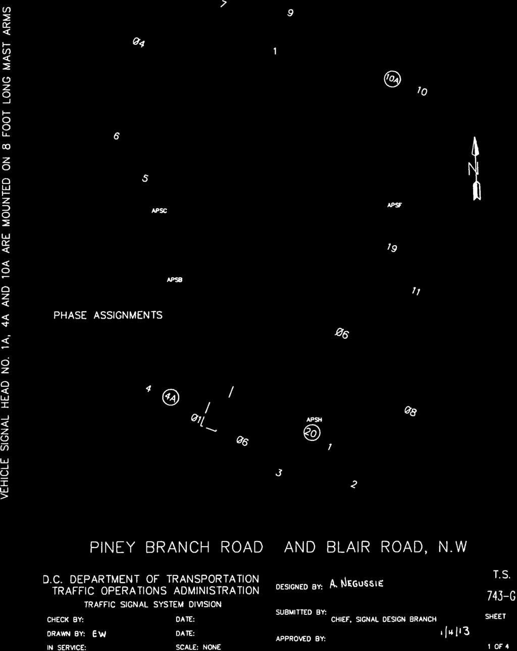
3 Takoma Metro Station 1. INTROUCTION The Takoma Metro Station is located on the Red Line in the Washington Metropolitan rea Transit System. It serves the area of Takoma Park, Maryland and the Takoma neighborhood of Washington.C. new residential apartment development is being proposed at the existing Kiss & Ride site to the northeast of the station. The purpose of this technical memorandum is to document the existing traffic conditions in the vicinity of the Takoma Metro Station, and also assess the traffic impacts from the proposed Joint evelopment for its projected opening date of the year 22. This technical memorandum is organized in the following manner: Study rea and Intersections Existing Conditions 22 No-Build Conditions 22 Build Conditions 1.1 Study rea and Intersections The Takoma Metro Station is located immediately south of C-Maryland borderline. It is bounded by Cedar Street to the east, Piney Branch Road to the west, Eastern venue to the north, and Blair Road and Cedar Street to the south. The studied intersections include four signalized intersections and five un-signalized intersections, listed as follows: 1. Eastern venue and Piney Branch Road (signalized) 2. Eastern venue and Holly venue (un-signalized) 3. Eastern venue and Kiss & Ride Facility (un-signalized) 4. Eastern venue and Bus ccess (un-signalized) 5. Eastern venue and Cedar Street (un-signalized) 6. Carroll Street and Cedar Street (signalized) 7. Carroll Street and Bus ccess (un-signalized) 8. Cedar Street and Blair Road and 4th Street (signalized) 9. Blair Road and Piney Branch Road (signalized) Figure 1 shows the study area, study intersections, and locations of the proposed development site at the Takoma Metro Station. Traffic nalysis Technical Memorandum 1 November 213

4 Takoma Metro Station Figure 1: Study rea, Study Intersections and Proposed evelopment Site 1.2 Existing Conditions This section presents the existing traffic conditions on the roadways adjacent to project and the purpose of this analysis is to establish the base conditions Field Observation Field observations were performed in the study area during the M and PM peak periods. The purpose of these field visits was to investigate the existing roadway and geometric conditions, traffic control operations, pedestrian/bicycle activities, and transit operations. These factors could affect the traffic operations at the study intersections Traffic The major congestion within the study area is observed at the intersection of Blair Road and Piney Branch Road. Vehicles experience long delays along eastbound and westbound Blair Road approaching Piney Branch Road during both M and PM peak hours. The westbound queues on Blair Road spill back to Cedar Street, and the eastbound queues extend beyond Fern Place in the M and PM. One major cause of the congestion is the insufficient duration of the green time at Piney Branch Road and Blair Road traffic signalized operation. Since there is only one travel lane on Blair Road, left-turning or rightturning vehicles were observed blocking the though traffic in some cycles. However, the Blair Road traffic queues do not block vehicles coming from the adjacent side streets such as ahlia Street or Chestnut Street. Traffic nalysis Technical Memorandum 2 November 213
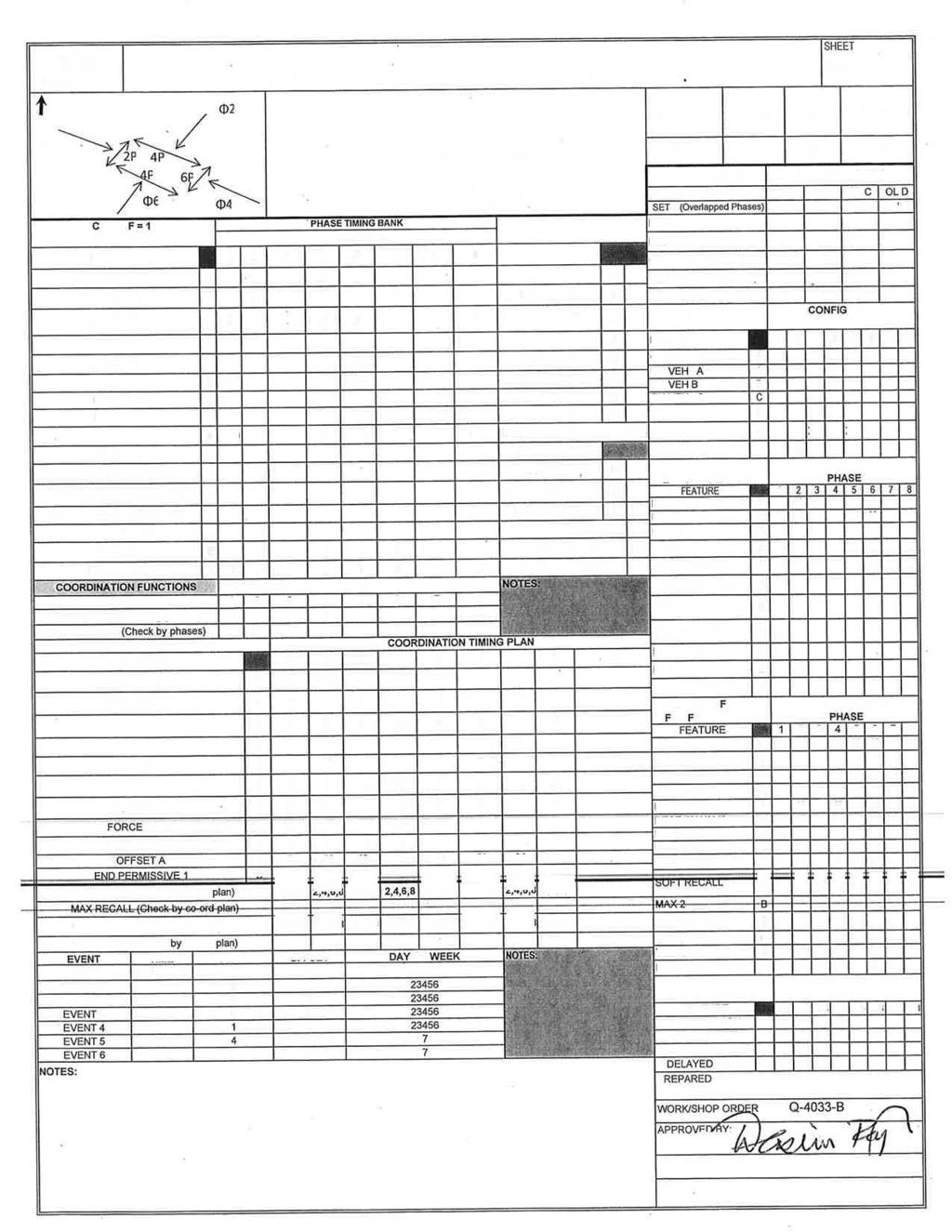
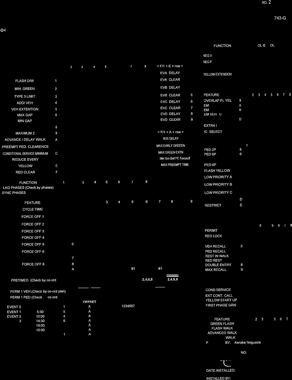
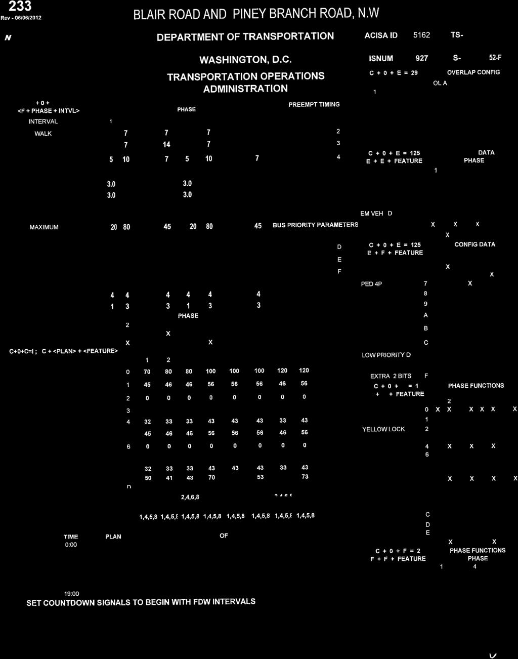
5 Takoma Metro Station Long queues were also observed on the following approaches: Southbound Piney Branch Road approaching Eastern venue in the M peak hour Northbound Piney Branch Road approaching Blair Road in the PM peak hour and on Westbound Carroll Street approaching Cedar Street in the M peak hour. However, these queues were cleared during most cycles. ll other signalized and un-signalized intersections are operating at acceptable conditions Bus Operation The Takoma Metro Station is served by WMT s Metrobus and Montgomery County s Ride-On Bus service. There are 16 bus lines serving the station during the M and PM peak hours. There are 9 bus bays provided at the station while 1 bay is currently not assigned to any bus route. WMT buses including bus routes 52/53/54, F1/F2, K2 and 62/63 use 4 bus bays, and Ride On buses including Lines 3, 12, 13, 14, 16, 18, 24, 25 use the other 4 bus bays. espite the fact that the two bus-access intersections are un-signalized, buses currently do not appear to encounter any problem in entering and exiting the station Park and Ride and Kiss and Ride There are no long-term Park and Ride facilities provided at the Takoma Metro Station. The Kiss & Ride and short-term parking lots are located to the northeast of the metro station. No congestion or overcrowding was observed at the Kiss & Ride/Short-term parking lots. Informal drop-off and pickup also occurs on Cedar Street adjacent to the station entrance. However, these vehicles do not create traffic congestion Pedestrians Sidewalk is provided on all the streets within the study area. Heavy pedestrian activity was observed on Carroll Street, Blair Road and Eastern venue Bicycle ccording to the 212 bike parking census, the Takoma Metro Station has the second-highest number of bike users in the Metro system. Many bicyclists were observed along Blair Road, Piney Branch Road, Eastern venue, and Carroll Street. However, no bike lanes are provided on any of these corridors. Cyclists either ride on the curb-side parking lane, or share the travel lane with cars ata Collection Turning movement counts at study intersections were collected in mid-september, 213 during the M peak period (6: a.m. 1: a.m.), and PM peak period (3: p.m. 7: p.m.). ccording to the data reports, the peak hour is between 7:45 a.m. and 8:45 a.m. in the morning, and between 5:3 p.m. and 6:3 p.m. in the afternoon. The highest hourly traffic volumes were used for M and PM peak hour traffic analysis. ppendix includes turning movement counts collected from the field. Signal timing at signalized study intersections was provided by istrict epartment of Transportation (OT). ppendix B shows the signal timing sheets. Traffic nalysis Technical Memorandum 3 November 213
6 Takoma Metro Station Methodology traffic analysis was performed for the study intersections using the micro-simulation tool VISSIM. Traffic operation was assessed using Measures of Effectiveness (MOE), including elay (seconds per vehicle), Level of Service (LOS), and queue length (feet) at the study intersections. Intersection LOS analysis provides a measurement of delay and service conditions for all approaches to the intersection. The HCM 21 edition uses LOS as a qualitative measure to describe the operating conditions at signalized and un-signalized intersections based on control delay per vehicle (seconds). The LOS range of through F represents driving conditions from best to worst. Table 1 presents the LOS thresholds for signalized and un-signalized intersections per the HCM 21. Table 1: LOS Thresholds for Signalized and Un-signalized Intersections Signalized Intersections Un-signalized Intersections elay (sec/veh) LOS elay (sec/veh) LOS <= 1 <= 1 > 1 2 B > 1 15 B > 2 35 C > C > > > 55 8 E > 35 5 E > 8 F > 5 F Source: HCM 21. The VISSIM models were run 2 times, and the average output results were tabulated and analyzed to determine the overall conditions at the study intersections during the M and PM peak hours. In order to replicate the existing peak hour traffic conditions at study intersections, the M and PM peak hour models were calibrated based on field data and observations nalysis Results This section summarizes the delay, LOS and queue results from VISSIM at each study intersection during M and PM peak hours. See ppendix C for the MOE summary for the existing M and PM peak hour conditions from VISSIM analysis. The results indicate that the VISSIM outputs are consistent with field observations. Vehicles on Blair Road approaching Piney Branch Road experience LOS E and LOS F in both M and PM peak periods. The westbound queues on Blair Road starting at Piney Branch spill back beyond Cedar Street, which makes westbound vehicles approaching Cedar Street experience LOS E and F in the M and PM, respectively. Northbound Piney Branch Road has long queues in the PM peak hour approaching Blair Road intersection. The 95th-percentile queue on northbound Piney Branch Road is approximately 1,1 feet long No-Build Conditions 22 No-Build represents the background traffic condition in 22 excluding the proposed joint developments at the Takoma Metro Station. 22 was selected as the analysis year because that is the date the development is planned to open. Traffic nalysis Technical Memorandum 4 November 213
7 Takoma Metro Station No-Build Volume Projections MWCOG 2.3 model was used to project the traffic growth from 213 to 22 (excluding the development at the Takoma Metro Station). MWCOG model indicates that three of the local jurisdictions including Washington,C., Prince George s County, and Montgomery County are showing more than 1% total increase in households and employment from 21 to 22. Silver Spring, which is located to the northeast of the Takoma Metro Station, expects significant growth in both jobs and number of residents. This study, assumed a total growth of 15% from 213 to 23 in the M and PM peak period that is equivalent to an annual traffic growth rate of 2% No-Build nalysis Results ue to the traffic growth through 22, the existing signal timing or roadway alignment may potentially fail to support the future traffic volumes. Note that this would be the case even if the proposed WMT joint development project is not implemented. Several scenarios were tested to assess the future traffic conditions and to potentially improve the traffic operations for 22 No-Build, including: 1) Keeping the existing signal timing and lane configurations; 2) djusting the signal timing while keeping the existing lane configurations; and 3) djusting the signal timing and lane configurations No-Build Scenario 1: Kept existing signal timing and existing lane configurations In Scenario 1, the signal timing and roadway lane configurations assumed for 22 models would be the same as the existing conditions. See ppendix C for the detailed MOE results for the 22 No-Build Scenario 1 from VISSIM analysis. s shown in the results, several signalized and un-signalized intersections experience level-of-service downgrades in 22 No-Build when they are compared with the existing conditions. uring the M peak hour, the level of service for the intersection of Carroll Street and Cedar Street downgrades from C to E. The westbound approach experiences LOS F with more than 1,5 feet length of queue. The intersection of Piney Branch Road and Blair Road downgrades from LOS to F. Both westbound and eastbound approaches on Blair Road experience significant delays. The westbound queue on Blair Road extends to the upstream intersection of Cedar Street, Blair Road and 4th Street, resulting in significant delays and queues at this upstream intersection. The intersection of Cedar Street, Blair road and 4th Street also operates with LOS F. The westbound Blair Road approach experiences significant delays of 423 seconds per vehicle in the M peak hour. The PM traffic conditions are similar to the M. part from three signalized intersections level of service downgrading to LOS E or F, several un-signalized intersections along Eastern venue also downgrade to LOS E or F. The major cause is the queues on eastbound Eastern venue at Piney Branch Road is blocking the vehicles from the side streets, causing long delays on the side streets. In summary, the existing signal operation and facilities are not able to provide adequate capacity for future traffic growth in the region. potential remedy would be adjusting signal timing and improving lane configurations No-Build Scenario 2: djusted signal timing and kept existing lane configurations In Scenario 2, signal timing at four signalized study intersections were optimized for the purpose of reducing the average vehicle delay. The cycle length remains 1 seconds, which is the same as the existing conditions. For example, the green signal time provided for Blair Road is extended in the M peak hour to reduce the approach delay while keeping the LOS on Piney Branch Road at an acceptable Traffic nalysis Technical Memorandum 5 November 213
8 Takoma Metro Station level. See ppendix C for the detailed MOE summary for the 22 No-Build Scenario 2 from VISSIM analysis. s compared to the results in Scenario 1, Scenario 2 shows an improvement in traffic operation in the M peak hour. uring the M peak hour, the intersection of Carroll Street and Cedar Street improves from LOS E in Scenario 1 to LOS in Scenario 2, but westbound Carroll Street still has 1,5 feet-long queues. Similar improvements were observed at the intersection of Blair Road and Piney Branch Road where the LOS improves from F to E. ue to this improvement, the intersection of Cedar Street, Blair Road and 4th Street also improves from LOS F to. uring the PM peak hour, the LOS for un-signalized intersections along Eastern venue improves from LOS F to or better by adjusting signal timing at the intersection of Piney Branch Road and Eastern venue. The signalized intersection of Carroll Street and Cedar Street also improves from LOS E to C. However, the intersection of Cedar Street, Blair Road and 4th Street, and the intersection of Piney Branch road and Blair Road continue to operate with LOS F in Scenario 2. This indicates that adjusting the signal timing at these intersections does not essentially address the congestion problems along Piney Branch Road and Blair Road. In summary, traffic operation in the M is greatly improved by adjusting signal timing at four signalized intersections. However, optimizing signal timing does not improve the traffic operation at two signalized intersections in the PM No-Build Scenario 3: djusted signal timing and improved lane configurations In Scenario 2, the major operational problem in the M peak hour is the excessive queue on westbound Carroll Street and the two signalized intersections operating at LOS F in the PM peak hour. The proposed lane configuration improvement to solve the M operational problem is to provide additional 1 foot long westbound right-turn lane (pocket) on Carroll Street approaching Cedar Street intersection. For the PM peak hour, the proposed improvement is to restrict parking during peak hours and convert the curb-side parking lane into a travel lane on northbound Piney Branch Road between ahlia Street and Eastern venue. The proposed improvement provides an additional capacity to Piney Branch Road which will in turn improve the capacity of Blair Road intersection by providing more green time to Blair Road. Figure 2 shows the existing and proposed lane configurations for the year 22 on Piney Branch Road. See ppendix C for the detailed MOE VISSIM analysis summary result for the 22 No-Build Scenario 3. s shown in the results, the westbound right-turn pocket at the intersection of Carroll Street and Cedar Street helps reduce the westbound queues and improves the overall intersection level of service from to B during the M peak hour. The westbound queue length also decreases from 1,5 feet to approximately 4 feet. The proposed lane configurations along Piney Branch venue help alleviate traffic delays along Blair Road and improve the operation at the intersection of Piney Branch venue and Blair Road from LOS F to, and at the intersection of Blair Road, 4th Street and Cedar Street from LOS F to E. Traffic nalysis Technical Memorandum 6 November 213
9 Takoma Metro Station Figure 2: Existing and Proposed Lane Configurations on Piney Branch Road (Note: iagrams not to scale) Existing Lane Configuration Proposed Lane Configuration for 22 Eastern ve Eastern ve Piney Branch Rd Blair Rd Piney Branch Rd Blair Rd ahlia St ahlia St Median Parking Median Traffic nalysis Technical Memorandum 7 November 213
. The conceptual site plan is shown in Figure 3.")
10 Build Volume Projections evelopment Plan Takoma Metro Station new residential building on a site shared with a Metro Kiss & Ride and short-term parking facility is proposed at the Takoma Metro Station. The new residential building would include 212 apartment units and 19 parking spaces (excluding Kiss & Ride and short-term parking for the metro). The conceptual site plan is shown in Figure 3. Figure 3: Conceptual Site Plan Trip Generation The ITE Trip Generation Manual 9th Edition was used to estimate the generated trips from the proposed development at the Takoma Metro Station. Table 2 shows the land use type and trip generation rates/equations used to estimate total generated trips. Table 3 shows the calculated site-generated trips including transit, walk/bike and vehicular trips. Table 2: Land Use Type and Trip Generation Rates/Equations Use Residential Land Use Type partments Feature 212 Units Rate/ Equations (M).49 Unit In/Out Rate (M) (%) 2/8 Rate/ Equations (PM).55 Unit In/Out Rate (PM) (%) 65/35 Table 3: Site-Generated Trips M PM Land Use Total Trips In Out Total Trips In Out Residential Traffic nalysis Technical Memorandum 8 November 213
11 Takoma Metro Station Mode Share Transit and walk/bike trips were not considered for purposes of trip generation calculation, although they are accounted for in the final Build analysis and evaluation. The 25 evelopment-related Ridership Survey conducted by the Washington Metropolitan rea Transit uthority (WMT) studies the travel behavior of persons traveling to and from office, residential, hotel and retail sites near Metrorail stations in the Washington.C. metropolitan area. For residential trips, the 25 Survey investigates the mode share for residential sites within ¼ mile walking distance at a variety of metro stations. The average mode share at these metro stations is listed as follows: 11% walk/bike trips 48% transit trips 41% vehicle trips This study assumes the same mode share to estimate the vehicular trips at the Takoma Metro Station. Table 4 presents the total vehicular trips entering and exiting the development sites during the M and PM peak hour. Table 4: Generated Vehicular Trips M PM Land Use In Out In Out Residential Trip istribution The future new development site would share the same access intersection/driveway with the metro Kiss & Ride and short-term parking trips. The distribution of the generated vehicular trips at the access intersection is assumed to follow the same traffic pattern as the vehicles coming from Holly venue. The distribution is comparable because the trips from Holly venue are also residential trips. The existing traffic distribution was used as a guide for determining the trip distribution at other intersections. Figures 4 and 5 show the trip distribution for the new generated trips in the M and PM peak hours, respectively. Traffic nalysis Technical Memorandum 9 November 213

12 Takoma Metro Station Figure 4: Trip istribution in the M Traffic nalysis Technical Memorandum 1 November 213

13 Takoma Metro Station Figure 5: Trip istribution in the PM nalysis Results 22 Build models assume the same lane configurations as 22 No-Build Scenario 3. Signal timings were adjusted to accommodate the site generated trips. See ppendix C for the detailed delay and LOS results for 22 Build scenarios. s compared to the 22 No-Build Scenario 3, the intersection of Holly venue and Eastern venue downgrades from LOS C to in the M peak hour. The intersection of the Kiss & Ride entrance/exit and Eastern venue also downgrades from LOS C to in both M and PM due to the additional trips added to the network. However, these intersections still operate at an acceptable level of service condition. Table 5 shows a summary of LOS at the study intersections in each scenario. The detailed results are included in ppendix C. Traffic nalysis Technical Memorandum 11 November 213
14 Takoma Metro Station Table 5: Summary of LOS LOS M PM No-Build No-Build No. Intersections Ex S1 S2 S3 Build Ex S1 S2 S3 Build 1 Eastern ve and Piney Branch C C C C 2 Eastern ve and Holly ve B C C C B F C C C 3 Eastern ve and Kiss & Ride B C C C C F C C 4 Eastern ve and Bus ccess E 5 Eastern ve and Cedar ve C C C C C C C C C C 6 Carroll St and Cedar ve C E B B C E C C B 7 Carroll St and Bus ccess 8 Cedar St, Blair Rd and 4th St F E F F E E 9 Piney Branch Rd and Blair Rd F E E F F Notes: Ex denotes Existing; S1 denotes Scenario 1; S2 denotes Scenario 2; S3 denotes Scenario Summary The study investigates the existing 22 No-Build and 22 Build traffic conditions at the Takoma Metro Station. In the existing conditions, westbound and eastbound Blair Road experience long delays when approaching Piney Branch Road in both M and PM. The congestion is caused by the insufficient signal green time provided for traffic on Blair Road. In the existing condition, westbound Carroll Street and southbound Piney Branch Road have long traffic queues in the M peak hour. The northbound Piney Branch Road have long traffic queues during the PM peak period. However, the queues were cleared during most cycles. 22 No-Build assumes an annual traffic growth rate of 2% to a total growth of 15% from the year 213 to 23. However, the existing signal operation and facilities are not able to provide adequate capacity to handle the future traffic growth in the region. Several intersections show LOS F in the M and PM peak hours. Proposed improvements for 22 No-Build conditions include signal timing optimization and lane configuration improvement. Lane configuration improvements include 1) adding a 1 foot long right-turn pocket on westbound Carroll Street approaching Cedar Street intersection; and 2) converting the curb side parking lane on northbound Piney Branch Road into a travel lane between ahlia Street and Eastern venue. The results indicate the traffic operation will improve with the proposed recommendations and all the intersections will operate with LOS E or better. The proposed lane configuration would be used for the Build analysis and evaluation. In 22 Build conditions, the additional vehicular trips from the development sites are 44 and 54 vehicles in the M and PM, respectively. The vehicles were distributed to the network by following the existing traffic pattern. The results indicate that the additional trips would slightly impact the traffic operation along Eastern venue, whereas at two un-signalized intersections, LOS downgrades from C to. However, these intersections would still operate at an acceptable level of service condition. Traffic nalysis Technical Memorandum 12 November 213
15 Takoma Metro Station ppendix Traffic nalysis Technical Memorandum November 213
16 Type of peak hour being reported: Intersection Peak Method for determining peak hour: Total Entering Volume LOCTION: Piney Branch Rd NW -- Eastern ve NW QC JOB #: CITY/STTE: Washington, C TE: Wed, Sep Peak-Hour: 7:45 M -- 8:45 M Peak 15-Min: 8: M -- 8:15 M Min Count Period Piney Branch Rd NW (Northbound) Piney Branch Rd NW (Southbound) Eastern ve NW (Eastbound) Eastern ve NW (Westbound) Total Hourly Totals Beginning t Left Thru Right U Left Thru Right U Left Thru Right U Left Thru Right U 6: M :15 M :3 M :45 M : M :15 M :3 M :45 M : M :15 M :3 M :45 M : M :15 M :3 M :45 M Peak 15-Min Northbound Southbound Eastbound Westbound Flowrates Left Thru Right U Left Thru Right U Left Thru Right U Left Thru Right U Total ll Vehicles Heavy Trucks Pedestrians Bicycles Railroad Stopped Buses Comments: Report generated on 9/2/213 1:59 M SOURCE: Quality Counts, LLC (
17 Type of peak hour being reported: Intersection Peak Method for determining peak hour: Total Entering Volume LOCTION: Piney Branch Rd NW -- Eastern ve NW QC JOB #: CITY/STTE: Washington, C TE: Wed, Sep Peak-Hour: 5:3 PM -- 6:3 PM Peak 15-Min: 5:45 PM -- 6: PM Min Count Period Piney Branch Rd NW (Northbound) Piney Branch Rd NW (Southbound) Eastern ve NW (Eastbound) Eastern ve NW (Westbound) Total Hourly Totals Beginning t Left Thru Right U Left Thru Right U Left Thru Right U Left Thru Right U 3: PM :15 PM :3 PM :45 PM : PM :15 PM :3 PM :45 PM : PM :15 PM :3 PM :45 PM : PM :15 PM :3 PM :45 PM Peak 15-Min Northbound Southbound Eastbound Westbound Flowrates Left Thru Right U Left Thru Right U Left Thru Right U Left Thru Right U Total ll Vehicles Heavy Trucks Pedestrians Bicycles Railroad Stopped Buses Comments: Report generated on 9/2/213 1:59 M SOURCE: Quality Counts, LLC (
18 Type of peak hour being reported: Intersection Peak Method for determining peak hour: Total Entering Volume LOCTION: Holly ve NW -- Eastern ve NW QC JOB #: CITY/STTE: Takoma Park, C TE: Wed, Sep Peak-Hour: 7:45 M -- 8:45 M Peak 15-Min: 8: M -- 8:15 M Min Count Period Holly ve NW (Northbound) Holly ve NW (Southbound) Eastern ve NW (Eastbound) Eastern ve NW (Westbound) Total Hourly Totals Beginning t Left Thru Right U Left Thru Right U Left Thru Right U Left Thru Right U 6: M :15 M :3 M :45 M : M :15 M :3 M :45 M : M :15 M :3 M :45 M : M :15 M :3 M :45 M Peak 15-Min Northbound Southbound Eastbound Westbound Flowrates Left Thru Right U Left Thru Right U Left Thru Right U Left Thru Right U Total ll Vehicles Heavy Trucks Pedestrians Bicycles Railroad Stopped Buses Comments: Report generated on 9/2/213 1:59 M SOURCE: Quality Counts, LLC (
19 Type of peak hour being reported: Intersection Peak Method for determining peak hour: Total Entering Volume LOCTION: Holly ve NW -- Eastern ve NW QC JOB #: CITY/STTE: Takoma Park, C TE: Wed, Sep Peak-Hour: 5:3 PM -- 6:3 PM Peak 15-Min: 6: PM -- 6:15 PM Min Count Period Holly ve NW (Northbound) Holly ve NW (Southbound) Eastern ve NW (Eastbound) Eastern ve NW (Westbound) Total Hourly Totals Beginning t Left Thru Right U Left Thru Right U Left Thru Right U Left Thru Right U 3: PM :15 PM :3 PM :45 PM : PM :15 PM :3 PM :45 PM : PM :15 PM :3 PM :45 PM : PM :15 PM :3 PM :45 PM Peak 15-Min Northbound Southbound Eastbound Westbound Flowrates Left Thru Right U Left Thru Right U Left Thru Right U Left Thru Right U Total ll Vehicles Heavy Trucks Pedestrians Bicycles Railroad Stopped Buses Comments: Report generated on 9/2/213 1:59 M SOURCE: Quality Counts, LLC (
20 Type of peak hour being reported: Intersection Peak Method for determining peak hour: Total Entering Volume LOCTION: Cedar St NW -- Eastern ve NW QC JOB #: CITY/STTE: Washington, C TE: Tue, Sep Peak-Hour: 7:3 M -- 8:3 M Peak 15-Min: 7:45 M -- 8: M Min Count Period Cedar St NW (Northbound) Cedar St NW (Southbound) Eastern ve NW (Eastbound) Eastern ve NW (Westbound) Total Hourly Totals Beginning t Left Thru Right U Left Thru Right U Left Thru Right U Left Thru Right U 6: M :15 M :3 M :45 M : M :15 M :3 M :45 M : M :15 M :3 M :45 M : M :15 M :3 M :45 M Peak 15-Min Northbound Southbound Eastbound Westbound Flowrates Left Thru Right U Left Thru Right U Left Thru Right U Left Thru Right U Total ll Vehicles Heavy Trucks Pedestrians Bicycles Railroad Stopped Buses Comments: Report generated on 9/2/213 1:59 M SOURCE: Quality Counts, LLC (
21 Type of peak hour being reported: Intersection Peak Method for determining peak hour: Total Entering Volume LOCTION: Cedar St NW -- Eastern ve NW QC JOB #: CITY/STTE: Washington, C TE: Tue, Sep Peak-Hour: 5:3 PM -- 6:3 PM Peak 15-Min: 5:45 PM -- 6: PM Min Count Period Cedar St NW (Northbound) Cedar St NW (Southbound) Eastern ve NW (Eastbound) Eastern ve NW (Westbound) Total Hourly Totals Beginning t Left Thru Right U Left Thru Right U Left Thru Right U Left Thru Right U 3: PM :15 PM :3 PM :45 PM : PM :15 PM :3 PM :45 PM : PM :15 PM :3 PM :45 PM : PM :15 PM :3 PM :45 PM Peak 15-Min Northbound Southbound Eastbound Westbound Flowrates Left Thru Right U Left Thru Right U Left Thru Right U Left Thru Right U Total ll Vehicles Heavy Trucks Pedestrians Bicycles Railroad Stopped Buses Comments: Report generated on 9/2/213 1:59 M SOURCE: Quality Counts, LLC (
22 Type of peak hour being reported: Intersection Peak Method for determining peak hour: Total Entering Volume LOCTION: Cedar St NW -- Carroll St NW QC JOB #: CITY/STTE: Washington, C TE: Wed, Sep Peak-Hour: 8: M -- 9: M Peak 15-Min: 8:3 M -- 8:45 M Min Count Period Cedar St NW (Northbound) Cedar St NW (Southbound) Carroll St NW (Eastbound) Carroll St NW (Westbound) Total Hourly Totals Beginning t Left Thru Right U Left Thru Right U Left Thru Right U Left Thru Right U 6: M :15 M :3 M :45 M : M :15 M :3 M :45 M : M :15 M :3 M :45 M : M :15 M :3 M :45 M Peak 15-Min Northbound Southbound Eastbound Westbound Flowrates Left Thru Right U Left Thru Right U Left Thru Right U Left Thru Right U Total ll Vehicles Heavy Trucks Pedestrians Bicycles Railroad Stopped Buses Comments: Report generated on 9/2/213 1:59 M SOURCE: Quality Counts, LLC (
23 Type of peak hour being reported: Intersection Peak Method for determining peak hour: Total Entering Volume LOCTION: Cedar St NW -- Carroll St NW QC JOB #: CITY/STTE: Washington, C TE: Wed, Sep Peak-Hour: 6: PM -- 7: PM Peak 15-Min: 6: PM -- 6:15 PM Min Count Period Cedar St NW (Northbound) Cedar St NW (Southbound) Carroll St NW (Eastbound) Carroll St NW (Westbound) Total Hourly Totals Beginning t Left Thru Right U Left Thru Right U Left Thru Right U Left Thru Right U 3: PM :15 PM :3 PM :45 PM : PM :15 PM :3 PM :45 PM : PM :15 PM :3 PM :45 PM : PM :15 PM :3 PM :45 PM Peak 15-Min Northbound Southbound Eastbound Westbound Flowrates Left Thru Right U Left Thru Right U Left Thru Right U Left Thru Right U Total ll Vehicles Heavy Trucks Pedestrians Bicycles 3 3 Railroad Stopped Buses Comments: Report generated on 9/2/213 1:59 M SOURCE: Quality Counts, LLC (
24 Type of peak hour being reported: Intersection Peak Method for determining peak hour: Total Entering Volume LOCTION: Blair Rd NW -- Piney Branch Rd NW QC JOB #: CITY/STTE: Washington, C TE: Wed, Sep Peak-Hour: 7:45 M -- 8:45 M Peak 15-Min: 8: M -- 8:15 M Min Count Period Blair Rd NW (Northbound) Blair Rd NW (Southbound) Piney Branch Rd NW (Eastbound) Piney Branch Rd NW (Westbound) Total Hourly Totals Beginning t Left Thru Right U Left Thru Right U Left Thru Right U Left Thru Right U 6: M :15 M :3 M :45 M : M :15 M :3 M :45 M : M :15 M :3 M :45 M : M :15 M :3 M :45 M Peak 15-Min Northbound Southbound Eastbound Westbound Flowrates Left Thru Right U Left Thru Right U Left Thru Right U Left Thru Right U Total ll Vehicles Heavy Trucks Pedestrians Bicycles Railroad Stopped Buses Comments: Report generated on 9/2/213 1:59 M SOURCE: Quality Counts, LLC (
25 Type of peak hour being reported: Intersection Peak Method for determining peak hour: Total Entering Volume LOCTION: Blair Rd NW -- Piney Branch Rd NW QC JOB #: CITY/STTE: Washington, C TE: Wed, Sep Peak-Hour: 5:15 PM -- 6:15 PM Peak 15-Min: 6: PM -- 6:15 PM Min Count Period Blair Rd NW (Northbound) Blair Rd NW (Southbound) Piney Branch Rd NW (Eastbound) Piney Branch Rd NW (Westbound) Total Hourly Totals Beginning t Left Thru Right U Left Thru Right U Left Thru Right U Left Thru Right U 3: PM :15 PM :3 PM :45 PM : PM :15 PM :3 PM :45 PM : PM :15 PM :3 PM :45 PM : PM :15 PM :3 PM :45 PM Peak 15-Min Northbound Southbound Eastbound Westbound Flowrates Left Thru Right U Left Thru Right U Left Thru Right U Left Thru Right U Total ll Vehicles Heavy Trucks 4 4 Pedestrians Bicycles Railroad Stopped Buses Comments: Report generated on 9/2/213 1:59 M SOURCE: Quality Counts, LLC (
26 Type of peak hour being reported: Intersection Peak Method for determining peak hour: Total Entering Volume LOCTION: Bus Entry -- Eastern ve NW QC JOB #: CITY/STTE: Washinton, C TE: Wed, Sep Peak-Hour: 8: M -- 9: M Peak 15-Min: 8:45 M -- 9: M Min Count Period Bus Entry (Northbound) Bus Entry (Southbound) Eastern ve NW (Eastbound) Eastern ve NW (Westbound) Total Hourly Totals Beginning t Left Thru Right U Left Thru Right U Left Thru Right U Left Thru Right U 6: M :15 M :3 M :45 M : M :15 M :3 M :45 M : M :15 M :3 M :45 M : M :15 M :3 M :45 M Peak 15-Min Northbound Southbound Eastbound Westbound Flowrates Left Thru Right U Left Thru Right U Left Thru Right U Left Thru Right U Total ll Vehicles Heavy Trucks Pedestrians Bicycles Railroad Stopped Buses Comments: Report generated on 9/2/213 1:59 M SOURCE: Quality Counts, LLC (
27 Type of peak hour being reported: Intersection Peak Method for determining peak hour: Total Entering Volume LOCTION: Bus Entry -- Eastern ve NW QC JOB #: CITY/STTE: Washinton, C TE: Wed, Sep Peak-Hour: 5:3 PM -- 6:3 PM Peak 15-Min: 6: PM -- 6:15 PM Min Count Period Bus Entry (Northbound) Bus Entry (Southbound) Eastern ve NW (Eastbound) Eastern ve NW (Westbound) Total Hourly Totals Beginning t Left Thru Right U Left Thru Right U Left Thru Right U Left Thru Right U 3: PM :15 PM :3 PM :45 PM : PM :15 PM :3 PM :45 PM : PM :15 PM :3 PM :45 PM : PM :15 PM :3 PM :45 PM Peak 15-Min Northbound Southbound Eastbound Westbound Flowrates Left Thru Right U Left Thru Right U Left Thru Right U Left Thru Right U Total ll Vehicles Heavy Trucks Pedestrians Bicycles Railroad Stopped Buses Comments: Report generated on 9/2/213 1:59 M SOURCE: Quality Counts, LLC (
28 Type of peak hour being reported: Intersection Peak Method for determining peak hour: Total Entering Volume LOCTION: Bus Exit -- Carroll St NW QC JOB #: CITY/STTE: Washington, C TE: Wed, Sep Peak-Hour: 7:45 M -- 8:45 M Peak 15-Min: 8:3 M -- 8:45 M Min Count Period Bus Exit (Northbound) Bus Exit (Southbound) Carroll St NW (Eastbound) Carroll St NW (Westbound) Total Hourly Totals Beginning t Left Thru Right U Left Thru Right U Left Thru Right U Left Thru Right U 6: M :15 M :3 M :45 M : M :15 M :3 M :45 M : M :15 M :3 M :45 M : M :15 M :3 M :45 M Peak 15-Min Northbound Southbound Eastbound Westbound Flowrates Left Thru Right U Left Thru Right U Left Thru Right U Left Thru Right U Total ll Vehicles Heavy Trucks Pedestrians Bicycles 1 1 Railroad Stopped Buses Comments: Report generated on 9/2/213 1:59 M SOURCE: Quality Counts, LLC (
29 Type of peak hour being reported: Intersection Peak Method for determining peak hour: Total Entering Volume LOCTION: Bus Exit -- Carroll St NW QC JOB #: CITY/STTE: Washington, C TE: Wed, Sep Peak-Hour: 5:45 PM -- 6:45 PM Peak 15-Min: 6: PM -- 6:15 PM Min Count Period Bus Exit (Northbound) Bus Exit (Southbound) Carroll St NW (Eastbound) Carroll St NW (Westbound) Total Hourly Totals Beginning t Left Thru Right U Left Thru Right U Left Thru Right U Left Thru Right U 3: PM :15 PM :3 PM :45 PM : PM :15 PM :3 PM :45 PM : PM :15 PM :3 PM :45 PM : PM :15 PM :3 PM :45 PM Peak 15-Min Northbound Southbound Eastbound Westbound Flowrates Left Thru Right U Left Thru Right U Left Thru Right U Left Thru Right U Total ll Vehicles Heavy Trucks Pedestrians Bicycles 1 1 Railroad Stopped Buses Comments: Report generated on 9/2/213 1:59 M SOURCE: Quality Counts, LLC (
30 Type of peak hour being reported: Intersection Peak Method for determining peak hour: Total Entering Volume LOCTION: Kiss & Ride wy -- Eastern ve NW QC JOB #: CITY/STTE: Washington, C TE: Wed, Sep Peak-Hour: 7:45 M -- 8:45 M Peak 15-Min: 8: M -- 8:15 M Min Count Period Kiss & Ride wy (Northbound) Kiss & Ride wy (Southbound) Eastern ve NW (Eastbound) Eastern ve NW (Westbound) Total Hourly Totals Beginning t Left Thru Right U Left Thru Right U Left Thru Right U Left Thru Right U 6: M :15 M :3 M :45 M : M :15 M :3 M :45 M : M :15 M :3 M :45 M : M :15 M :3 M :45 M Peak 15-Min Northbound Southbound Eastbound Westbound Flowrates Left Thru Right U Left Thru Right U Left Thru Right U Left Thru Right U Total ll Vehicles Heavy Trucks Pedestrians Bicycles Railroad Stopped Buses Comments: Report generated on 9/2/213 1:59 M SOURCE: Quality Counts, LLC (
31 Type of peak hour being reported: Intersection Peak Method for determining peak hour: Total Entering Volume LOCTION: Kiss & Ride wy -- Eastern ve NW QC JOB #: CITY/STTE: Washington, C TE: Wed, Sep Peak-Hour: 5:3 PM -- 6:3 PM Peak 15-Min: 6: PM -- 6:15 PM Min Count Period Kiss & Ride wy (Northbound) Kiss & Ride wy (Southbound) Eastern ve NW (Eastbound) Eastern ve NW (Westbound) Total Hourly Totals Beginning t Left Thru Right U Left Thru Right U Left Thru Right U Left Thru Right U 3: PM :15 PM :3 PM :45 PM : PM :15 PM :3 PM :45 PM : PM :15 PM :3 PM :45 PM : PM :15 PM :3 PM :45 PM Peak 15-Min Northbound Southbound Eastbound Westbound Flowrates Left Thru Right U Left Thru Right U Left Thru Right U Left Thru Right U Total ll Vehicles Heavy Trucks Pedestrians Bicycles 6 6 Railroad Stopped Buses Comments: Report generated on 9/2/213 1:59 M SOURCE: Quality Counts, LLC (
32 U- Turns Right Thru to 4th St NW Thru 749 SW Tech Center r, Ste B15 Tigard, OR Counts: ll Vehicle Counts Peak Hour: Highlighted In Blue Location: Blair Rd NW & Cedar St NW Peak 15-minutes: Highlighted In Orange ate: 9/24/213 Peak Hour Factor (M):.911 Peak Hour Factor (PM):.92 Blair Rd NW (Southbound) Cedar St NW (Westbound) Blair Rd NW (Northbound) 4th St NW (Northbound) Left U- Turns Right Thru Left to 4th St NW Left U- Turns Right Thru Left Left to 4th St NW U- Turns Right to Blair Rd NW Right to Cedar St NW Thru to Blair Rd NW Left to Cedar St NW U- Turns Cedar St NW (Eastbound) Right to 4th St NW Right Thru Left 6: M :15 M :3 M :45 M : M :15 M :3 M :45 M : M :15 M :3 M :45 M : M :15 M :3 M :45 M Totals U- Turns Blair Rd NW (Southbound) Cedar St NW (Westbound) Blair Rd NW (Northbound) 4th St NW (Northbound) Cedar St NW (Eastbound) Right Thru to 4th St NW Thru Left U- Turns Right Thru Left to 4th St NW Left U- Turns Right Thru Left Left to 4th St NW U- Turns Right to Blair Rd NW Right to Cedar St NW Thru to Blair Rd NW Left to Cedar St NW U- Turns Right to 4th St NW Right Thru Left 3: PM :15 PM :3 PM :45 PM : PM :15 PM :3 PM :45 PM : PM :15 PM :3 PM :45 PM : PM :15 PM :3 PM :45 PM Totals
33 749 SW Tech Center r, Ste B15 Tigard, OR Counts: Pedestrian Counts Location: Blair Rd NW & Cedar St NW ate: 9/24/213 Peds Blair Rd NW (Southbound) Cedar St NW (Westbound) Blair Rd NW (Northbound) 4th St NW (Northbound) Right Thru to 4th St NW Thru Left Peds Right Thru Left to 4th St NW Left Peds Right Thru Left Left to 4th St NW Peds Right to Blair Rd NW Right to Cedar St NW Thru to Blair Rd NW Left to Cedar St NW Peds Cedar St NW (Eastbound) Right to 4th St NW Right Thru Left 6: M :15 M :3 M :45 M : M :15 M :3 M :45 M : M :15 M :3 M :45 M : M :15 M :3 M :45 M Totals Mid Crosswal k Peds Blair Rd NW (Southbound) Cedar St NW (Westbound) Blair Rd NW (Northbound) 4th St NW (Northbound) Cedar St NW (Eastbound) Right Thru to 4th St NW Thru Left Peds Right Thru Left to 4th St NW Left Peds Right Thru Left Left to 4th St NW Peds Right to Blair Rd NW Right to Cedar St NW Thru to Blair Rd NW Left to Cedar St NW Peds Right to 4th St NW Right Thru Left 3: PM :15 PM :3 PM :45 PM : PM :15 PM :3 PM :45 PM : PM :15 PM :3 PM :45 PM : PM :15 PM :3 PM :45 PM Totals Mid Crosswal k
34 Takoma Metro Station ppendix B Traffic nalysis Technical Memorandum November 213

35
36
37
38
39
40
41
42
43
44
45
46
47
48
49
50
51
52
53
54
55
56
57
58
59
60
61
62
63
64
65
66
67
68
69
70
71
72
73
74
Traffic Impact Study WestBranch Residential Development Davidson, NC March 2016
 Traffic Impact Study WestBranch Residential Development Davidson, NC March 216 TRAFFIC IMPACT STUDY FOR THE WestBranch Residential Development LOCATED IN DAVIDSON, NC Prepared For: Lennar Carolinas, LLC
TECHNICAL MEMORANDUM. Kevin Even, P.E. Village Engineer and Public Works Director Village of Waunakee. From: Kevin Wehner, P.E. KL Engineering, Inc.
 TEHIL MEMORUM To: Kevin Even, P.E. Village Engineer and Public Works irector Village of Waunakee 400 King James Way, uite 200 Madison, Wisconsin 3719 608-663-1218 www.klengineering.com From: Kevin Wehner,
Appendix B: Forecasting and Traffic Operations Analysis Framework Document
 Existing Conditions Report - Appendix Appendix B: Forecasting and Traffic Operations Analysis Framework Document This document defines the methodology and assumptions that will be used in the traffic forecasting
TRAFFIC ASSESSMENT River Edge Colorado
 TRAFFIC ASSESSMENT River Edge Colorado Submitted by: Fehr & Peers 621 17th Street, Ste. 231 Denver, CO 8293 (33) 296-43 December, 21 App. M-2 Traffic Assessment River Edge Colorado December 21 TABLE OF
Highway 111 Corridor Study
 Highway 111 Corridor Study June, 2009 LINCOLN CO. HWY 111 CORRIDOR STUDY Draft Study Tea, South Dakota Prepared for City of Tea Sioux Falls Metropolitan Planning Organization Prepared by HDR Engineering,
TRAFFIC IMPACT ANALYSIS
 TRAFFIC IMPACT ANALYSIS FOR THE CHAMPAIGN UNIT#4 SCHOOL DISTRICT PROPOSED HIGH SCHOOL (SPALDING PARK SITE) IN THE CITY OF CHAMPAIGN Final Report Champaign Urbana Urbanized Area Transportation Study 6/24/2014
Shockoe Bottom Preliminary Traffic and Parking Analysis
 Shockoe Bottom Preliminary Traffic and Parking Analysis Richmond, Virginia August 14, 2013 Prepared For City of Richmond Department of Public Works Prepared By 1001 Boulders Pkwy Suite 300, Richmond, VA
Complete Street Analysis of a Road Diet: Orange Grove Boulevard, Pasadena, CA
 Complete Street Analysis of a Road Diet: Orange Grove Boulevard, Pasadena, CA Aaron Elias, Bill Cisco Abstract As part of evaluating the feasibility of a road diet on Orange Grove Boulevard in Pasadena,
Ownership Lots 17 & 18 (Part of Lot 14), Montgomery Auto Sales Park
, Montgomery Auto Sales Park") Traffic Impact Analysis Ownership Lots 17 & 18 (Part of Lot 14), Montgomery Auto Sales Park Silver Spring, MD Lot 17: Site Plan No. 821413 Lot 18: Site Plan No. 821414 Filing Number: 13-TS-1198527A Prepared
Traffic Impact Analysis Ownership Lots 17 & 18 (Part of Lot 14), Montgomery Auto Sales Park Silver Spring, MD Lot 17: Site Plan No. 821413 Lot 18: Site Plan No. 821414 Filing Number: 13-TS-1198527A Prepared
133 rd Street and 132 nd /Hemlock Street 132 nd Street and Foster Street MINI ROUNDABOUTS. Overland Park, Kansas
 133 rd Street and 132 nd /Hemlock Street 132 nd Street and Foster Street MINI ROUNDABOUTS Overland Park, Kansas September 1, 2017 TABLE OF CONTENTS 1. INTRODUCTION... 1 2. LITERATURE REVIEW... 1 3. CONCEPT
MEMORANDUM. Charlotte Fleetwood, Transportation Planner
 MEMORANDUM Date: Updated August 22, 2017 To: Organization: Charlotte Fleetwood, Transportation Planner Boston Transportation Department From: Jason DeGray, P.E., PTOE, Regional Director of Engineering
CITY OF OAKLAND. 27th Street Bikeway Feasibility and Design. Final Report (v3) March 23, Kimley-Horn and Associates, Inc.
 March 23, Kimley-Horn and Associates, Inc.") CITY OF OAKLAND 27th Street Bikeway Feasibility and Design Final Report (v3) March 23, 2007 PREPARED BY: Kimley-Horn and Associates, Inc. Table of Contents 1. Introduction 3 2. 27 th Street/Bay Place Corridor
CITY OF OAKLAND 27th Street Bikeway Feasibility and Design Final Report (v3) March 23, 2007 PREPARED BY: Kimley-Horn and Associates, Inc. Table of Contents 1. Introduction 3 2. 27 th Street/Bay Place Corridor
Appendix C. NORTH METRO STATION AREA TRAFFIC IMPACT STATEMENT 88th Avenue Station
 Appendix C NORTH METRO STATION AREA TRAFFIC IMPACT STATEMENT 88th Avenue Station Prepared for: Regional Transportation Department and URS Corporation as part of the North Metro EIS David Evans and Associates,
Figure 1: East West Connector Alignment Alternatives Concept Drawing
 Page 2 of 9 Figure 1: East West Connector Alignment Alternatives Concept Drawing The Montebello Drive extension will run north south and connect Wilsonville Road to the Boones Ferry Road to Brown Road
THIS PAGE LEFT BLANK INTENTIONALLY
 GA SR 25 Spur at Canal Road Transportation Impact Analysis PREPARED FOR GLYNN COUNTY, GEORGIA 1725 Reynolds Street, Suite 300 Brunswick, Georgia 31520 PREPARED BY 217 Arrowhead Boulevard Suite 26 Jonesboro,
Gateway Transportation Study
 Gateway Transportation Study Amherst, Massachusetts SUBMITTED TO University of Massachusetts Amherst Town of Amherst SUBMITTED BY Vanasse Hangen Brustlin, Inc. Watertown, Massachusetts March 213 Back of
5858 N COLLEGE, LLC N College Avenue Traffic Impact Study
 5858 N COLLEGE, LLC nue Traffic Impact Study August 22, 2016 Contents Traffic Impact Study Page Preparer Qualifications... 1 Introduction... 2 Existing Roadway Conditions... 5 Existing Traffic Conditions...
Transportation Impact Study for Abington Terrace
 Transportation Impact Study for Abington Terrace Abington Township, Montgomery County, PA Sandy A. Koza, P.E., PTOE PA PE License Number PE059911 Prepared by McMahon Associates, Inc. 425 Commerce Drive,
Brian McHugh, Buckhead Community Improvement District. SUBJECT: Wieuca Road at Phipps Boulevard Intersection Improvements Project
 MEMO TO: FROM: Brian McHugh, Buckhead Community Improvement District Jagan Kaja, AICP, WSP Parsons Brinckerhoff SUBJECT: Wieuca Road at Phipps Boulevard Intersection Improvements Project DATE: October
INDUSTRIAL BUILDING 3009 HAWTHORNE ROAD CITY OF OTTAWA TRANSPORTATION OVERVIEW REVISED. Prepared for: Canada Inc.
 INDUSTRIAL BUILDING 3009 HAWTHORNE ROAD CITY OF OTTAWA TRANSPORTATION OVERVIEW REVISED Prepared for: 7849648 Canada Inc. Octiober 1, 2015 114-598 Overview_2.doc D. J. Halpenny & Associates Ltd. Consulting
List of Attachments. Location Map... Site Plan... City of Lake Elsinore Circulation Element... City of Lake Elsinore Roadway Cross-Sections...
 List of Attachments Exhibits Location Map... Site Plan... City of Lake Elsinore Circulation Element... City of Lake Elsinore Roadway Cross-Sections... Existing Lane Geometry and Traffic Controls... Existing
Harrah s Station Square Casino
 Transportation Analysis Harrah s Station Square Casino Pittsburgh, Pennsylvania Submitted To: City of Pittsburgh and Pennsylvania Gaming Control Board Prepared By: DKS Associates GAI Consultants December
TRAFFIC IMPACT STUDY And A TRAFFIC SIGNAL WARRANT ANALYSIS FOR A SENIOR LIVING AND APARTMENT DEVELOPMENT
 TRAFFIC IMPACT STUDY And A TRAFFIC SIGNAL WARRANT ANALYSIS FOR A SENIOR LIVING AND APARTMENT DEVELOPMENT DEERFIELD TOWNSHIP, WARREN COUNTY, OHIO Nantucket Circle and Montgomery Road () Prepared for: ODLE
1609 E. FRANKLIN STREET HOTEL TRAFFIC IMPACT STUDY EXECUTIVE SUMMARY
 1609 E. FRANKLIN STREET HOTEL TRAFFIC IMPACT STUDY EXECUTIVE SUMMARY Prepared for: The Town of Chapel Hill Public Works Department Traffic Engineering Division Prepared by: HNTB North Carolina, PC 343
TRANSPORTATION ANALYSIS REPORT US Route 6 Huron, Erie County, Ohio
 TRANSPORTATION ANALYSIS REPORT US Route 6 Huron, Erie County, Ohio December 12, 2012 Prepared for: The City of Huron 417 Main Huron, OH 44839 Providing Practical Experience Technical Excellence and Client
Wesbrook Place Traffic Analysis of Redistributed Dwelling Units
 Wesbrook Place Traffic Analysis of Redistributed Dwelling Units 1 Summary This report presents an analysis of the changes in traffic volumes in the Wesbrook Place neighbourhood associated with a redistribution
Low Level Road Improvements Traffic Analysis. Report
 Low Level Road Improvements Traffic Analysis Report June, 22 Table of Contents. INTRODUCTION.... LOW LEVEL ROAD PROJECT....2 STUDY AREA....2. West-End Corridor Improvements... 2.2.2 East-End Corridor Improvements...
FRONT RANGE CROSSINGS TRAFFIC IMPACT STUDY
 FRONT RANGE CROSSINGS TRAFFIC IMPACT STUDY Prepared for: City of Thornton And Colorado Department of Transportation Prepared by: 11 Blake Street, Suite 2 Denver, Colorado 822 Contact: Brian Bern, PE, PTOE
Project Report. South Kirkwood Road Traffic Study. Meadows Place, TX October 9, 2015
 Meadows Place, TX October 9, 2015 Contents 1 Introduction... 1 2 Data Collection... 1 3 Existing Roadway Network... 2 4 Traffic Volume Development... 2 5 Warrant Analysis... 3 6 Traffic Control Alternative
Reference number /VP. Lafayette Downtown Congestion Study - Additional Traffic Analysis
 To James Hinkamp and Tony Coe, City of Lafayette Date January 19, 2017 Copies Reference number 243381/VP From Michael Iswalt and Vanessa Peers File reference 4-05 Subject Lafayette Downtown Congestion
NEW YORK CENTRAL PARK SUBDIVISION BLAIS STREET/ST-PIERRE STREET EMBRUN, ONTARIO TRAFFIC IMPACT STUDY. Prepared for:
 NEW YORK CENTRAL PARK SUBDIVISION BLAIS STREET/ST-PIERRE STREET EMBRUN, ONTARIO TRAFFIC IMPACT STUDY Prepared for: Solidex Holdings Limited & Investissement Maurice Lemieux Investments Attn: Mr. Anthony
Metropolitan Park 4/5
 Traffic Impact Study and Transportation Management Plan Metropolitan Park 4/ Arlington County, VA July 3, 0 Prepared by: 40 Connecticut Avenue Suite 00 Washington, DC 003 Tel: 0.9. Fax: 0.. 394 Centreville
OFFICE/RETAIL DEVELOPMENT 1625 BANK STREET OTTAWA, ONTARIO TRANSPORTATION BRIEF. Prepared for: Canada Inc.
 OFFICE/RETAIL DEVELOPMENT 1625 BANK STREET OTTAWA, ONTARIO TRANSPORTATION BRIEF Prepared for: 9402209 Canada Inc. December 15, 2015 115-625 Report_2.doc D. J. Halpenny & Associates Ltd. Consulting Transportation
Comments EXECUTIVE SUMMARY
 Comments 1. Under any Alternatives, MCDOT should provide better at-grade pedestrian crossing of Georgia Avenue and Forest Glen Road, including improved crosswalks with wider medians and adequate signal
Addendum #1 to the Alternatives Analysis:
 ddendum #1 to the lternatives nalysis: ontents 1. Introduction... 2 2. Scope... 2 3. etermination of Intersection and Roadway Volumes... 4 4. VISSIM Model evelopment... 5 5. 6. 4.1. IndyGo Operational
HENDERSON DEVELOPMENT 213, 217, 221, 221 ½, 223 HENDERSON AVENUE and 65 TEMPLETON STREET OTTAWA, ONTARIO TRANSPORTATION OVERVIEW.
 HENDERSON DEVELOPMENT 213, 217, 221, 221 ½, 223 HENDERSON AVENUE and 65 TEMPLETON STREET OTTAWA, ONTARIO TRANSPORTATION OVERVIEW Prepared for: 2294170 Ontario Inc. February 2, 2017 117-652 Report_1.doc
Road Conversion Study Plumas Street
 Plumas Street Phase I Submitted to The Regional Transportation Commission of Washoe County Submitted by Zong Tian, Ph.D., P.E. Saeedeh Farivar Haiyuan Li, Ph.D. Center for Advanced Transportation Education
HILTON GARDEN INN HOTEL HOTEL EXPANSION 2400 ALERT ROAD, OTTAWA TRANSPORTATION BRIEF. Prepared for:
 HILTON GARDEN INN HOTEL HOTEL EXPANSION 2400 ALERT ROAD, OTTAWA TRANSPORTATION BRIEF Prepared for: Bona Building & Management Co. Ltd. Place Vanier, 333 North River Road Vanier, Ontario K1L 8B9 October
INDUSTRIAL BUILDING 1660 COMSTOCK ROAD CITY OF OTTAWA TRANSPORTATION OVERVIEW. Prepared for:
 INDUSTRIAL BUILDING 1660 COMSTOCK ROAD CITY OF OTTAWA TRANSPORTATION OVERVIEW Prepared for: Simluc Contractors Limited 2550 Blackwell Street, Ottawa K1B 5R1 October 18, 2013 113-584 Overview_1.doc D. J.
Magnolia Place. Traffic Impact Analysis. Prepared for: City of San Mateo. Prepared by: Hexagon Transportation Consultants, Inc.
 Magnolia Place Traffic Impact Analysis Prepared for: City of San Mateo Prepared by: Hexagon Transportation Consultants, Inc. Updated January 4, 2010 Table of Contents 1. Introduction...1 2. Existing Conditions...6
MEETING FACILITY 2901 GIBFORD DRIVE CITY OF OTTAWA TRANSPORTATION BRIEF. Prepared for: Holiday Inn Express 2881 Gibford Drive Ottawa, ON K1V 2L9
 MEETING FACILITY 2901 GIBFORD DRIVE CITY OF OTTAWA TRANSPORTATION BRIEF Prepared for: Holiday Inn Express 2881 Gibford Drive Ottawa, ON K1V 2L9 December 18, 2012 112-566 Brief_1.doc D. J. Halpenny & Associates
Arlington Public Schools Thomas Jefferson Site Evaluation Transportation Networks. Thomas Jefferson Working Group Meeting #6 November 10, 2014
 Arlington Public Schools Thomas Jefferson Site Evaluation Transportation Networks Thomas Jefferson Working Group Meeting #6 November 10, 2014 2 3 INTRODUCTION 4 Goal of our work: Identify and assess multi-modal
DEPARTMENT OF ENVIRONMENTAL SERVICES. North Harrison Street (Lee Highway to Little Falls Road) Comparative Analysis. Prepared for:
 Comparative Analysis. Prepared for:") DEPARTMENT OF ENVIRONMENTAL SERVICES North Harrison Street (Lee Highway to Little Falls Road) Comparative Analysis Prepared for: Arlington County Department of Environmental Services 2100 Clarendon Boulevard,
DEPARTMENT OF ENVIRONMENTAL SERVICES North Harrison Street (Lee Highway to Little Falls Road) Comparative Analysis Prepared for: Arlington County Department of Environmental Services 2100 Clarendon Boulevard,
Preliminary Transportation Analysis
 Preliminary Transportation Analysis Goals of a Robust, Multimodal Transportation Network Safe Accessible/Connected Efficient Comfortable Context-Sensitive Motor Vehicle: Continue to analyze the data to
4. ENVIRONMENTAL IMPACT ANALYSIS 9. TRANSPORTATION AND TRAFFIC
 4. ENVIRONMENTAL IMPACT ANALYSIS 9. TRANSPORTATION AND TRAFFIC 4.9.1 INTRODUCTION The following section addresses the Proposed Project s impact on transportation and traffic based on the Traffic Study
MEDICAL/OFFICE BUILDING 1637 BANK STREET OTTAWA, ONTARIO TRANSPORTATION OVERVIEW. Prepared for:
 MEDICAL/OFFICE BUILDING 1637 BANK STREET OTTAWA, ONTARIO TRANSPORTATION OVERVIEW Prepared for: 2434984 Ontario Inc. 13-5510 Canotek Road Ottawa, Ontario K1J 9J5 June 4, 2015 115-613 Report_2.doc D. J.
South Albion-Bolton Community Plan North Hill Supermarket Transportation Study Part B: Evaluation of Alternatives
 Community Plan North Hill Supermarket Transportation Study Part B: Evaluation of Alternatives Prepared for: The Town of Caledon August 9 Transportation Solutions Ltd. 43 Forest Road Cambridge, ON N1S 3B4
List of Exhibits...ii
 One Brickell Traffic Study TABLE OF CONTENTS List of Exhibits...ii EXECUTIVE SUMMARY...1 1. INTRODUCTION...2 1.1 Study Area...2 1.2 Study Objective...5 2. EXISTING TRAFFIC CONDITIONS...6 2.1 Data Collection...6
Evaluation of M-99 (Broad Street) Road Diet and Intersection Operational Investigation
 Road Diet and Intersection Operational Investigation") Evaluation of M-99 (Broad Street) Road Diet and Intersection Operational Investigation City of Hillsdale, Hillsdale County, Michigan June 16, 2016 Final Report Prepared for City of Hillsdale 97 North Broad
Evaluation of M-99 (Broad Street) Road Diet and Intersection Operational Investigation City of Hillsdale, Hillsdale County, Michigan June 16, 2016 Final Report Prepared for City of Hillsdale 97 North Broad
Traffic Impact Study. Roderick Place Columbia Pike Thompson s Station, TN. Transportation Group, LLC Traffic Engineering and Planning
 F i s c h b a c h Transportation Group, LLC Traffic Engineering and Planning Traffic Impact Study Roderick Place Columbia Pike Thompson s Station, TN Prepared March 2016 Ms. Gillian L. Fischbach, P.E.,
East 12 th Street Bikeway Feasibility Study
 Final Report East 12 th Street Bikeway Feasibility Study Prepared for: City of Oakland Public Works Agency Submitted by: 180 Grand Avenue, Suite 250 Oakland, CA 94612 Phone: (510) 839-1742; Fax: (510)
QUICKIE C STORE AND GAS BAR 1780 HERON ROAD OTTAWA, ONTARIO TRANSPORTATION BRIEF. Prepared for:
 QUICKIE C STORE AND GAS BAR 1780 HERON ROAD OTTAWA, ONTARIO TRANSPORTATION BRIEF Prepared for: Quickie Convenience Stores Larny Holdings Ltd. c/o PBC Group April 15, 2015 115-615 Report_1.doc D. J. Halpenny
Walmart (Store # ) 60 th Street North and Marion Road Sioux Falls, South Dakota
 60 th Street North and Marion Road Sioux Falls, South Dakota") Walmart (Store #4865-00) 60 th Street North and Marion Road Sioux Falls, South Dakota Prepared for: Wal-Mart Stores, Inc. Bentonville, Arkansas Prepared by: Kimley-Horn and Associates, Inc. ã2013 Kimley-Horn
Walmart (Store #4865-00) 60 th Street North and Marion Road Sioux Falls, South Dakota Prepared for: Wal-Mart Stores, Inc. Bentonville, Arkansas Prepared by: Kimley-Horn and Associates, Inc. ã2013 Kimley-Horn
Public Involvement Meeting Tuesday, June 13, Albany Shaker Road Corridor Study
 Public Involvement Meeting Tuesday, June 13, 2017 Albany Shaker Road Corridor Study Agenda / Meeting Outline 1. Introduce the project 2. Complete Streets 3. Share/confirm our findings 4. Your Opinion 5.
Traffic Impact Analysis Chatham County Grocery Chatham County, NC
 Chatham County Grocery Chatham County, NC TABLE OF CONTENTS 1. INTRODUCTION... 1 1.1. Location and Study Area... 1 1.2. Proposed Land Use and Access... 2 1.3. Adjacent Land Uses... 2 1.4. Existing ways...
Michael A. Werthmann, PE, PTOE Principal
 9575 West Higgins Road, Suite 400 Rosemont, Illinois 60018 p: 847-518-9990 f: 847-518-9987 MEMORANDUM TO: FROM: Brian Lorenc GHB-630, LLC Michael A. Werthmann, E, TOE rincipal Luay R. Aboona, E rincipal
Figure 1: Vicinity Map of the Study Area
 ARIZONA TEXAS NEW MEXICO OKLAHOMA May 5, 2016 Mr. Anthony Beach, P.E. BSP Engineers 4800 Lakewood Drive, Suite 4 Waco, Texas 76710 Re: Intersection and Access Analysis along Business 190 in Copperas Cove
Lyons Avenue/Dockweiler Road Extension Project Draft Environmental Impact Report. Appendix I Traffic Impact Study
 Lyons Avenue/Dockweiler Road Extension Project Draft Environmental Impact Report Appendix I Traffic Impact Study Street 0 80-1947 500.4501 RITA ld Court 0 91355-1096 400.7401 LA n Avenue 0 590-3745 300-9301
APARTMENT BUILDING DEVELOPMENT 1161 HERON ROAD OTTAWA, ONTARIO TRANSPORTATION IMPACT STUDY. Prepared for:
 APARTMENT BUILDING DEVELOPMENT 1161 HERON ROAD OTTAWA, ONTARIO TRANSPORTATION IMPACT STUDY Prepared for: 1649362 Ontario Inc. c/o Manor Park Management 231 Brittany Drive, Suite D Ottawa ON K1K 0R8 July
Technical Memorandum TRAFFIC IMPACT STUDY. RIDLEY ROAD CONVENIENCE STORE Southampton County, VA. Prepared for: Mr. David Williams.
 Technical Memorandum TRFFIC IMPCT STUDY RIDLEY ROD CONVENIENCE STORE Southampton County, V Prepared for: Mr. David Williams By: Charles Smith, P.E., PTOE EPR Charlottesville, V July 2014 1 TBLE OF CONTENTS
ALLEY 24 TRAFFIC STUDY
 ALLEY 24 TRAFFIC STUDY in City of Frostburg, Maryland January 2013 3566 Teays Valley Road Hurricane, WV Office: (304) 397-5508 www.denniscorporation.com Alley 24 Traffic Study January 2013 Frostburg, Maryland
CITY OF WEST LAKE HILLS. Forest View Neighborhood Traffic Calming Study
 CITY OF WEST LAKE HILLS 901 South Mopac Expressway Building V, Suite 220 Austin, Texas 78746 Texas P.E. Firm Registration No. F-929 Klotz Associates Final Report Submittal: March 20, 2015 Revised Final
HIGHBURY AVENUE/HAMILTON ROAD INTERSECTION IMPROVEMENTS PUBLIC INFORMATION CENTRE 1 MAY 14, 2015
 HIGHBURY AVENUE/HAMILTON ROAD INTERSECTION IMPROVEMENTS Municipal Class Environmental Assessment PUBLIC INFORMATION CENTRE 1 MAY 14, 2015 ACCESSIBILITY Under the Accessibility Standards 2015 for Customer
Traffic Impact Analysis Walton Acres at Riverwood Athletic Club Clayton, NC
 Traffic Impact Analysis Walton Acres at Riverwood Athletic Club Clayton, NC 1. TABLE OF CONTENTS INTRODUCTION...1 1.1. Site Location and Study Area...1 1.2. Proposed Land Use and Site Access...2 1.3.
Simulating Street-Running LRT Terminus Station Options in Dense Urban Environments Shaumik Pal, Rajat Parashar and Michael Meyer
 Simulating Street-Running LRT Terminus Station Options in Dense Urban Environments Shaumik Pal, Rajat Parashar and Michael Meyer Abstract The Exposition Corridor transit project is a light rail project
Marina Loft (DRC 51-R-12)
") Marina Loft (DRC 51-R-12) traffic study prepared for: Cymbal Development OCtober 2012 Traf Tech October 1, 2012 Mr. Asi Cymbal - President Cymbal Development 3470 North Miami Avenue Upper Suite Miami,
Marina Loft (DRC 51-R-12) traffic study prepared for: Cymbal Development OCtober 2012 Traf Tech October 1, 2012 Mr. Asi Cymbal - President Cymbal Development 3470 North Miami Avenue Upper Suite Miami,
Henderson Avenue Mixed-Use Development
 Zoning Case: Z145-3 Traffic Impact Analysis Henderson Avenue Mixed-Use Development Dallas, TX October 26 th, 216 Kimley-Horn and Associates, Inc. Dallas, Texas Project #644827 Registered Firm F-928 Traffic
Los Altos Hills Town Council - June 18, 2015 Palo Alto City Council June 22, AGENDA ITEM #2.B Presentation
 Los Altos Hills Town Council - June 18, 2015 Palo Alto City Council June 22, 2015 AGENDA ITEM #2.B Presentation Previous Presentations Los Altos Hills Town Council in May 2014 and February 2015 Palo Alto
METHODOLOGY. Signalized Intersection Average Control Delay (sec/veh)
") Chapter 5 Traffic Analysis 5.1 SUMMARY US /West 6 th Street assumes a unique role in the Lawrence Douglas County transportation system. This principal arterial street currently conveys commuter traffic
Chapter 5 Traffic Analysis 5.1 SUMMARY US /West 6 th Street assumes a unique role in the Lawrence Douglas County transportation system. This principal arterial street currently conveys commuter traffic
Grant Avenue Streetscape
 REPORT TYPE GOES HERE Grant Avenue Streetscape PREPARED FOR City of Manassas 9027 Center Street Manassas, VA 20110 PREPARED BY 8300 Boone Boulevard Suite 700 Vienna, Virginia 22182 571.389.8121 July 31,
MONTGOMERY COUNTY PLANNING DEPARTMENT THE MARYLAND-NATIONAL CAPITAL PARK AND PLANNING COMMISSION
 MONTGOMERY COUNTY PLANNING DEPARTMENT THE MARYLAND-NATIONAL CAPITAL PARK AND PLANNING COMMISSION MCPB Item No. 4 Date: 04-17-14 2014 Mobility Assessment Report José Dory, Senior Planner, Functional Planning
Multnomah County Courthouse Relocation. Transportation Alternatives Analysis Technical Memorandum: FINAL
 Multnomah County Courthouse Relocation Portland, Oregon Transportation Alternatives Analysis Technical Memorandum: FIL Prepared for Multnomah County Facilities and Property Management Division 41 N Dixon
Bridge Street Corridor Study Report
 Bridge Street Corridor Study Report Prepared for: Prepared by: BRIDGE STREET CORRIDOR STUDY REPORT PREPARED FOR: CITY OF ARROYO GRANDE COMMUNITY DEVELOPMENT DEPARTMENT 300 EAST BRANCH STREET ARROYO GRANDE,
Meadow Woods Elementary School
 Drag and drop pic and stretch/crop to the limits of the blue rectangle (delete this text box) Meadow Woods Elementary School Drag and drop pic and stretch/crop to the limits of the blue rectangle (delete
FAIRFIELD INN & SUITES HOTEL 135 THAD JOHNSON PRIVATE OTTAWA TRANSPORTATION BRIEF. Prepared for:
 FAIRFIELD INN & SUITES HOTEL 135 THAD JOHNSON PRIVATE OTTAWA TRANSPORTATION BRIEF Prepared for: Bona Building & Management Co. Ltd. Place Vanier, 333 North River Road Vanier, Ontario K1L 8B9 August 12,
TABLE OF CONTENTS TABLE OF CONTENTS... I APPENDICES... III LIST OF EXHIBITS... V LIST OF TABLES... VII LIST OF ABBREVIATED TERMS...
 TABLE OF CONTENTS TABLE OF CONTENTS... I APPENDICES... III LIST OF EXHIBITS... V LIST OF TABLES... VII LIST OF ABBREVIATED TERMS... IX 1 INTRODUCTION... 1 1.1 Project Overview... 1 1.2 Analysis Scenarios...
Lake Whitney Elementary School
 Lake Whitney Elementary School SCHOOL ROUTE PLAN For LAKE WHITNEY ELEMENTARY SCHOOL LOCATION 18 ORANGE COUNTY Prepared for: ORANGE COUNTY SCHOOL ASSESSMENT PROGRAM ORANGE COUNTY PUBLIC WORKS Traffic Engineering
EXECUTIVE SUMMARY. Page 1 of 6
 EXECUTIVE SUMMARY The purpose of this report is to identify conformance with the original traffic impact study for the proposed retail development on Lot 5 of Riverdale Retail Filing No. 1 located on the
canopy Ithaca The Commons by Hilton
 Traffic Impact Study f or t h e p r o p o s e d canopy Ithaca The Commons by Hilton C i t y o f I t h a c a T o m p k i n s C o u n t y, N ew Y ork January 215 Project No. 347 Prepared For: 3 3 7 E l m
OTTAWA TRAIN YARDS PHASE 3 DEVELOPMENT CITY OF OTTAWA TRANSPORTATION IMPACT STUDY. Prepared for:
 OTTAWA TRAIN YARDS PHASE 3 DEVELOPMENT CITY OF OTTAWA TRANSPORTATION IMPACT STUDY Prepared for: The Ottawa Train Yards Inc. 223 Colonnade Road South, Suite 212 Nepean, Ontario K2E 7K3 January 17, 2012
ADVANCED TRANSIT OPERATIONS AND MODELING
 SOUTHERN DISTRICT OF INSTITUTE OF TRANSPORTATION ENGINEERS (SDITE) 2017 ADVANCED TRANSIT OPERATIONS AND MODELING SURESH KARRE, PE, PTOE ROBERT DUBNICKA, PE, TE, PTOE AGENDA Background Transit operations
HOLIDAY INN HOTEL 235 KING EDWARD AVENUE CITY OF OTTAWA TRANSPORTATION BRIEF. Prepared for:
 HOLIDAY INN HOTEL 235 KING EDWARD AVENUE CITY OF OTTAWA TRANSPORTATION BRIEF Prepared for: Momentum Planning & Communications 1165 Greenlawn Crescent Ottawa, ON K1L 6C2 June 29, 2015 115-618 Brief_1.doc
Traffic Impact Study for Rolling Ridge Redevelopment
 Traffic Impact Study for Rolling Ridge Redevelopment Webster Groves, Missouri October 19, 2018 Prepared For: Gershman Commercial Real Estate 150 North Meramec Avenue Suite 500 St. Louis, Missouri 63105
CITY OF OTTAWA ROADWAY MODIFICATION APPROVAL UNDER DELEGATED AUTHORITY
 RMA-2015-ATM-038 CITY OF OTTAWA ROADWAY MODIFICATION APPROVAL UNDER DELEGATED AUTHORITY DATE: April 22, 2015 SUBJECT Approval of Roadway Modifications Recommended through an Area Traffic Management Study
Prepared for Lutheran Services Carolinas. Project Number: /07/2017. Trinity Landing. New Hanover County, NC
 Prepared for Lutheran Services Carolinas Project Number: 16273 4/7/217 Trinity Landing New Hanover County, NC Trinity Landing Transportation Impact nalysis Prepared for Lutheran Services Carolinas New
TRANSPORTATION IMPACT STUDY
 Dundas MEP Developments Inc. City of Toronto 219 and 231 Dundas Street East, Proposed Mixed-Use Development TRANSPORTATION IMPACT STUDY 9782/2 April 216 LEA Consulting Ltd. Consulting Engineers & Planners
Mission Street Medical Office Development
 reet Medical Office Development Traffic Impact Analysis Prepared for: Palo Alto Medical Foundation February 23, 2012 Hexagon Office: 7888 Wren Avenue, Suite B121 Gilroy, CA 95020 Hexagon Job Number: 11RD11
Windy Ridge Elementary School
 Windy Ridge Elementary School SCHOOL ROUTE PLAN For WINDY RIDGE ELEMENTARY SCHOOL LOCATION 54 ORANGE COUNTY Prepared for: ORANGE COUNTY SCHOOL ASSESSMENT PROGRAM ORANGE COUNTY PUBLIC WORKS Traffic Engineering
Traffic Impact Memorandum. May 22, 2018
 BISHOP PROFESSIONAL DEVELOPMENT BUILDING Proposed Land-use Change & Parking Modification 3601 SW 31st Street Topeka, Kansas 66614 CFS Project No. 185077 Traffic Impact Memorandum May 22, 2018 Prepared
Memorandum Pershing Road Suite 400 Kansas City, MO Tel Fax
 Memorandum 2400 Pershing Road Suite 400 Kansas ity, MO 64108 Tel 816 329 8600 Fax 816 329 8601 www.transystems.com To: Mr. avid Gurss Kansas epartment of Transportation wight. Eisenhower State Office ldg.
Paul VI Redevelopment. Traffic Impact Study
 ATTACHMENT 5 Paul VI Redevelopment Traffic Impact Study April 18, 2017 PAUL VI REDEVELOPMENT TRAFFIC IMPACT STUDY CITY OF FAIRFAX, VIRGINIA Prepared for: IDI GROUP COMPANIES Prepared by: Wells + Associates,
EAST AND SOUTH STREET CITY OF ANAHEIM, CALIFORNIA
 T R A F F I C I M P A C T A N A LY S I S EAST AND SOUTH STREET CITY OF ANAHEIM, CALIFORNIA April 217 T R A F F I C I M P A C T A N A LY S I S EAST AND SOUTH STREET CITY OF ANAHEIM, CALIFORNIA Submitted
Traffic Circulation Study for Neighborhood Southwest of Mockingbird Lane and Airline Road, Highland Park, Texas
 ARIZONA TEXAS NEW MEXICO OKLAHOMA February 13, 2015 Mr. Meran Dadgostar P.E., R.S. Town of Highland Park 4700 Drexel Dr. Highland Park, Texas 75205 Re: Traffic Circulation Study for Neighborhood Southwest
Chapter 4 Traffic Analysis
 Chapter 4 Traffic Analysis PURPOSE The traffic analysis component of the K-68 Corridor Management Plan incorporates information on the existing transportation network, such as traffic volumes and intersection
Memorandum. Sunday, July 13, Saturday, July 19, 2014
 Memorandum To: David Lowin, Brooklyn Bridge Park Corporation From: Daniel Schack, AICP, PTP Date: Re: Brooklyn Bridge Park Pier 5/6 Loop Road Traffic Study Project No: 14-01-2407 At the request of Brooklyn
APS Stratford Project Transportation Analysis Overview. Stratford BLPC #5 June 1, 2015
 APS Stratford Project Transportation Analysis Overview Stratford BLPC #5 June 1, 2015 8 Arrival/dismissal observations and counts BLPC arrival/dismissal observations BLPC early release observation Williamsburg
TRAFFIC IMPACT STUDY
 TRAFFIC IMPACT STUDY for the GLEN ELLEN COUNTRY CLUB SENIOR RESIDENTIAL REDEVELOPMENT 84 Millis, Massachusetts Prepared by: McMahon Associates, Inc. Prepared for: Toll Brothers, Inc. August 216 DRAFT
Appendix B. Environmental Resource Technical Memorandum. Assessment on Travel Pattern and Access Impacts
 Appendix B Environmental Resource Technical Memorandum Assessment on Travel Pattern and Access Impacts TECHNICAL MEMORANDUM ENVIRONMENTAL RE-EVALUATION FOR UNION STATION TO OAK CLIFF DALLAS STREETCAR To:
LSC TRANSPORTATION CONSULTANTS, INC. 516 North Tejon Street Colorado Springs, CO (719) FAX (719)
 FAX (719)") LSC TRANSPORTATION CONSULTANTS, INC. 516 North Tejon Street Colorado Springs, CO 80903 (719) 633-2868 FAX (719) 633-5430 E-mail: lsc@lsccs.com May 15, 2009 Mr. Davis Farrar Western Slope Consulting, LLC
LSC TRANSPORTATION CONSULTANTS, INC. 516 North Tejon Street Colorado Springs, CO 80903 (719) 633-2868 FAX (719) 633-5430 E-mail: lsc@lsccs.com May 15, 2009 Mr. Davis Farrar Western Slope Consulting, LLC
CITY OF LOS ANGELES INTER-DEPARTMENTAL MEMORANDUM
 CITY OF LOS ANGELES INTER-DEPARTMENTAL MEMORANDUM Date: April 1, 219 To: Honorable City Council c/o City Clerk, Room 395, City Hall Attention: Honorable Mike Bonin, Chair, Transportation Committee From: