Evaluation of MODIS chlorophyll algorithms in
|
|
|
- Vernon Houston
- 6 years ago
- Views:
Transcription
1 Evaluation of MODIS chlorophyll algorithms in Australian continental shelf waters: The IMOS match up data base Schroeder T, Lovell J,, Clementson L, King E, Brando V 9 July 2014 Australian Marine Science Association Conference, Canberra, Australia
2 Motivation No consistent national validation approach
3 Motivation No coherent algorithm validation on continental scale Global algorithms are biased towards northern hemisphere data
4 The Australian bio optical data desert
5 Motivation No coherent algorithm validation on continental scale Global algorithms are biased towards northern hemisphere data IMOS Ocean Colour Sub facility is addressing data gap Compilation of a national bio optical data base
6 IMOS data updates to NASA SeaBASS (since Jan 2014)
7 In situ HPLC chlorophyll IMOS data base N= p// / p /
8 Motivation No coherent algorithm validation on continental scale Global algorithms are biased towards northern hemisphere data IMOS Ocean Colour Sub facility is addressing data gap Compilation of a national bio optical data base Production and provision of Ocean Colour data
9 L2 re mapped d swath h L2 continental scale mosaics In future also via
10 Motivation No coherent algorithm validation on continental scale Global algorithms are biased towards northern hemisphere data IMOS Ocean Colour Sub facility is addressing data gap Compilation of a national bio optical data base Production and provision of Ocean Colour data Evaluation of algorithm accuracy: Combining coincident in situ chlorophyll and remote sensing measurements
11 Which chlorophyll product to choose? IMOS MODIS A repository based on SeaDAS v7.0 processing Empirical algorithms OC3 (MODIS standard algorithm) Clark Semi analytical algorithms GSM (Garver Siegel Maritorena model) Carder
12 IMOS in situ HPLC data coverage Time constrain to satellite overpasses ±1 day All HPLC data (N=1992) ±1 day (N=262)
13 IMOS in situ HPLC data coverage Time constrain to satellite overpasses p ±2 hours All HPLC data (N=1992) ±1 day (N=262) ±2 hours (N=34)
14 Data distribution NOMAD vs IMOS
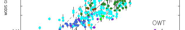
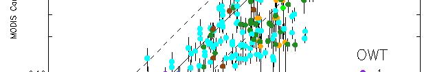
15 Match up Methodology For each in situ Chl a data from IMOS data base identify matching satellite images within ±2 hours upto ±1 day Extract satellite derived CHL observations at in situ locations within a 5 km radius for open ocean waters, 3 km for coastal waters, calculate median and standard deviation Apply quality control flags Land, cloud, glint, Sun zenith < 60, view zenith < 60,... Calculate statistics (RMSE, % error, bias) of match up pairs Classify match up pairs according to Optical Water Type (OWT) 8 classes (Moore et al. 2009) Extra class for cocolithophore bloom
16 Optical Water Type (OWT) classification Moore et al. 2009
17 OC3 MODIS A) Satellite CHL (M In situ CHL
18 OC3 MODIS A) Satellite CHL (M In situ CHL
19 OC3 MODIS A) Satellite CHL (M In situ CHL

20 OC3 MODIS A) Satellite CHL (M In situ CHL
21 OC3 MODIS A) Satellite CHL (M In situ CHL
22 OC3 MODIS A) Satellite CHL (M In situ CHL
23 OC3 MODIS A) Satellite CHL (M In situ CHL
24
25
26 N=60 N=264 ±3 h ±1 day
27 Match up Statistics ±1 Day OC3 Clark Carder GSM N RMSE MAPE Bias ±3 hr OC3 Clark Carder GSM N RMSE MAPE Bias
28 Conclusions IMOS OC sub facility provides a useful platform for nationally consistent evaluation of ocean colour products All data freely available through the IMOS portal Ongoing effort (currently secured until 06/2015) Optical Water Types vital to constrain match up analysis exclude out of range conditions larger deviations OWT 7,8,9 In situ HPLC does not confirm presence of cocolithophore (OWT9) Reducing time window for match ups improves statistics (except Carder) Empirical algorithms perform better than semi analytical Performance ranking: OC3, Clark, Carder, GSM
29 The IMOS bio optical data base needs your data! The IMOS bio optical data base needs your data! It is a community effort.
30 Thank you question? Dr Thomas Schroeder, Brisbane Acknowledgements: SeaDAS Development Group and the OPBG at NASA GSFC for development, support and distribution of the SeaDAS software
Inter-comparison of atmospheric correction algorithms over optically-complex waters
 Inter-comparison of atmospheric correction algorithms over optically-complex waters proposed by Cédric Jamet Laboratoire d'océanologie et de Géosciences UMR 8187, ULCO/CNRS 32 avenue Foch 62930 Wimereux,
The Pandonia network for ground validation of satellite-derived trace gas products
 Yonsei University, Seoul The for ground validation of satellite-derived trace gas products Alexander Cede 1,2 and Michel van Roozendael 3 for the Pandora team 1 LuftBlick, 2 NASA/GSFC, 3 BIRA Pandonia
SEA SURFACE TEMPERATURE RETRIEVAL USING TRMM MICROWAVE IMAGER SATELLITE DATA IN THE SOUTH CHINA SEA
 SEA SURFACE TEMPERATURE RETRIEVAL USING TRMM MICROWAVE IMAGER SATELLITE DATA IN THE SOUTH CHINA SEA Mohd Ibrahim Seeni Mohd and Mohd Nadzri Md. Reba Faculty of Geoinformation Science and Engineering Universiti
46 1 ( ) Vol. 46 Sup. 1
 Vol. 46 Sup. 1") 46 1 () Vol. 46 Sup. 1 2007 8 Journal of Xiamen University (Nat ural Science) Aug. 2007 1, 1,2, 1 3 (1. ( ),2., 361005) : SeaWiFS,, 2,16. 7 %, 0. 077 81, 0. 87. ( 38. 0 %,0. 152 4, 0. 56),. Gulf of Mexico
46 1 () Vol. 46 Sup. 1 2007 8 Journal of Xiamen University (Nat ural Science) Aug. 2007 1, 1,2, 1 3 (1. ( ),2., 361005) : SeaWiFS,, 2,16. 7 %, 0. 077 81, 0. 87. ( 38. 0 %,0. 152 4, 0. 56),. Gulf of Mexico
Global Ocean Internal Wave Database
 Global Ocean Internal Wave Database Victor Klemas Graduate College of Marine Studies University of Delaware Newark, DE 19716 phone: (302) 831-8256 fax: (302) 831-6838 email: klemas@udel.edu Quanan Zheng
High resolution wind fields over the Black Sea derived from Envisat ASAR data using an advanced wind retrieval algorithm
 High resolution wind fields over the Black Sea derived from Envisat ASAR data using an advanced wind retrieval algorithm Werner Alpers (1), Alexis Mouche (2), Andrei Yu. Ivanov (3), and Burghard Brümmer
Where are the Bathymetric Hot-Spots?
 Where are the Bathymetric Hot-Spots? Dave Monahan Center for Coastal and Ocean Mapping University of New Hampshire If I win really BIG at the Casino tonight Every now and then, there are news stories of
Freeboard changes of Drygalski and Mertz ice tongues in east Antarctica using altimetry data
 Freeboard changes of Drygalski and Mertz ice tongues in east Antarctica using altimetry data XIANWEI WANG 1 and DAVID M. HOLLAND 1, 2 1. Center for Global Sea Level Change, New York University Abu Dhabi.
The Cross-Calibrated Multi-Platform (CCMP) Ocean Vector Wind Analysis (V2.0)
 Ocean Vector Wind Analysis (V2.0)") The Cross-Calibrated Multi-Platform (CCMP) Ocean Vector Wind Analysis (V2.0) Carl A. Mears, L. Ricciardulli, J. Scott and F. J. Wentz Remote Sensing Systems Ross Hoffman, S. Mark Leidner Robert Atlas Atmospheric
The Cross-Calibrated Multi-Platform (CCMP) Ocean Vector Wind Analysis (V2.0) Carl A. Mears, L. Ricciardulli, J. Scott and F. J. Wentz Remote Sensing Systems Ross Hoffman, S. Mark Leidner Robert Atlas Atmospheric
Reprocessed QuikSCAT (V04) Wind Vectors with Ku-2011 Geophysical Model Function
 Wind Vectors with Ku-2011 Geophysical Model Function") Reprocessed QuikSCAT (V04) Wind Vectors with Ku-2011 Geophysical Model Function Lucrezia Ricciardulli and Frank Wentz Introduction In April 2011, we reprocessed the QuikSCAT ocean wind vectors using a
Reprocessed QuikSCAT (V04) Wind Vectors with Ku-2011 Geophysical Model Function Lucrezia Ricciardulli and Frank Wentz Introduction In April 2011, we reprocessed the QuikSCAT ocean wind vectors using a
Monitoring tidal movements in Cook Inlet, Alaska, using the integration of remote sensing data, GIS, and inundation models
 Monitoring tidal movements in Cook Inlet, Alaska, using the integration of remote sensing data, GIS, and inundation models Hua Liu Department of political Science and Geography Old Dominion University
Bias assessment of MODIS/MISR winds
 Bias assessment of MODIS/MISR winds Feng Lu, Yixuan Shou, Xiaohu Zhang, Jianmin Xu Office of System Development, National Satellite Meteorological Center/CMA 13th International Winds Workshop (IWW13),
Quantifying Wave Measurement Differences in Historical and Present Wave Buoy Systems
 Quantifying Wave Measurement Differences in Historical and Present Wave Buoy Systems R. E. Jensen 1, V. Swail 2, R.H. Bouchard 3, and B. Bradshaw 2 1 Coastal and Hydraulics Laboratory 2 Environment and
High Resolution Sea Surface Roughness and Wind Speed with Space Lidar (CALIPSO)
") High Resolution Sea Surface Roughness and Wind Speed with Space Lidar (CALIPSO) Yongxiang Hu NASA Langley Research Center Carl Weimer Ball Aerospace Corp. 1 CALIPSO Mission Overview CALIPSO seeks to improve
High Resolution Sea Surface Roughness and Wind Speed with Space Lidar (CALIPSO) Yongxiang Hu NASA Langley Research Center Carl Weimer Ball Aerospace Corp. 1 CALIPSO Mission Overview CALIPSO seeks to improve
Monitoring beach usage on Gold Coast beaches: Is it beneficial?
 Monitoring beach usage on Gold Coast beaches: Is it beneficial? Peta Williams 1, Gervase Tuxworth 2 and Chris Lane 2 1 Griffith Centre for Coastal Management (GCCM) Gold Coast Campus, Griffith University
Development of SAR-Derived Ocean Surface Winds at NOAA/NESDIS
 Development of SAR-Derived Ocean Surface Winds at NOAA/NESDIS Pablo Clemente-Colón, William G. Pichel, NOAA/NESDIS Frank M. Monaldo, Donald R. Thompson The Johns Hopkins University Applied Physics Laboratory
TRMM TMI and AMSR-E Microwave SSTs
 TMI and AMSR-E Microwave SSTs Chelle Gentemann, Frank Wentz, & Peter Ashcroft Gentemann@remss.com www.remss.com TMI/AMSR-E MW SST algorithm development Validation Results Sensor Issues Useful for Climate
Climate Change Scenarios for the Agricultural and Hydrological Impact Studies
 Climate Change Scenarios for the Agricultural and Hydrological Impact Studies Martin Dubrovský (WP 3, 5, 6) hotel Mendi, Halkidiki, Greece ***** 10-12. June 2009 scheme of cc impacts study GCM output obs.wea.series
Monitoring algal blooms using the MERIS Maximum Chlorophyll Index
 Monitoring algal blooms using the MERIS Maximum Chlorophyll Index Caren Binding & Tracie Greenberg, Bob Bukata, Sue Watson, Shannah Rastin, Jess Gould Workshop for Remote Sensing of Coastal and Inland
What s UP in the. Pacific Ocean? Learning Objectives
 What s UP in the Learning Objectives Pacific Ocean? In this module, you will follow a bluefin tuna on a spectacular migratory journey up and down the West Coast of North America and back and forth across
MISR CMVs. Roger Davies and Aaron Herber Physics Department
 MISR CMVs Roger Davies and Aaron Herber Physics Department Acknowledgements: MISR Science and Data Processing Team (especially Catherine Moroney and Mike Garay) From the AGU Fall Meeting 2009 MISR and
Modelled and observed winds in the Adriatic sea
 Modelled and observed winds in the Adriatic sea F. De Biasio, S.Zecchetto, A. della Valle ISAC-CNR Institute of Atmospheric Sciences and Climate Italian National Research Council http://www.esurge-venice.eu
Mining and Agricultural Productivity
 Mining and Agricultural Productivity - A presentation of preliminary results for Ghana The World Bank, Washington D.C., USA, 29 May 214 MAGNUS ANDERSSON, Senior Lecturer in Human Geography, Lund University,
Aquarius Brings New Understanding to Tropical Instability Waves (TIWs)
") Aquarius Brings New Understanding to Tropical Instability Waves (TIWs) Tong Lee1*, Gary Lagerloef2, Michelle M. Gierach1, Hsun-Ying Kao2, Simon Yueh1, Kathleen Dohan2 1NASA Jet Propulsion Laboratory, CalTech,
Aquarius Brings New Understanding to Tropical Instability Waves (TIWs) Tong Lee1*, Gary Lagerloef2, Michelle M. Gierach1, Hsun-Ying Kao2, Simon Yueh1, Kathleen Dohan2 1NASA Jet Propulsion Laboratory, CalTech,
Analysis of Wave Predictions from the Coastal Model Test Bed using cbathy
 Analysis of Wave Predictions from the Coastal Model Test Bed using cbathy Spicer Bak, Ty Hesser, Jane Smith U.S. Army Engineer Research & Development Center Duck, NC Coastal Model Test Bed Purpose: Automated
Climate Change Scenarios for the Agricultural and Hydrological Impact Studies
 Climate Change Scenarios for the Agricultural and Hydrological Impact Studies Martin Dubrovský (WP 3, 5, 6) Masarykova kolej, Praha ***** 25-27 November 2009 scheme of cc impacts study GCM output obs.wea.series
Sea Surface Temperature (SST) in South China Sea Retrieved from Chinese Satellite FY-3B VIRR Data
 in South China Sea Retrieved from Chinese Satellite FY-3B VIRR Data") Sea Surface Temperature (SST) in South China Sea Retrieved from Chinese Satellite FY-3B VIRR Data Chuqun CHEN*, Quanjun HE, Shilin TANG, Haibin YE State key Lab of Tropical Oceanography, South China Sea
Sea Surface Temperature (SST) in South China Sea Retrieved from Chinese Satellite FY-3B VIRR Data Chuqun CHEN*, Quanjun HE, Shilin TANG, Haibin YE State key Lab of Tropical Oceanography, South China Sea
JCOMM Technical Workshop on Wave Measurements from Buoys
 JCOMM Technical Workshop on Wave Measurements from Buoys Val Swail Chair, JCOMM Expert Team on Wind Waves and Storm Surges Neville Smith Vincent Cardone Peter Janssen Gerbrand Komen Peter Taylor WIND WAVES
Cooperative Navigation for Autonomous Underwater Vehicles. Navigare 2011, 4 May 2011, Bern
 Cooperative Navigation for Autonomous Underwater Vehicles Navigare 2011, 4 May 2011, Bern Distributed Intelligent Systems and Algorithms Laboratory disal.epfl.ch Alexander Bahr Land, atmosphere and sea
Boost Your Skills with On-Site Courses Tailored to Your Needs
 Boost Your Skills with On-Site Courses Tailored to Your Needs www.aticourses.com The Applied Technology Institute specializes in training programs for technical professionals. Our courses keep you current
Pathways Interns: Annika O Dea, Ian Conery, Andrea Albright
 1 REMOTE SENSING OF COASTAL MORPHODYNAMICS 237 237 237 217 217 217 2 2 2 8 119 27 252 174.59 255 255 255 163 163 163 131 132 122 239 65 53 11 135 12 112 92 56 62 12 13 12 56 48 13 12 111 Kate Brodie Brittany
Dynamic validation of Globwave SAR wave spectra data using an observation-based swell model. R. Husson and F. Collard
 Dynamic validation of Globwave SAR wave spectra data using an observation-based swell model. R. Husson and F. Collard Context 1978 1979 1980 1981 1982 1983 1984 1985 1986 1987 1988 1989 1990 1991 1992
OCEAN vector winds from the SeaWinds instrument have
 IEEE GEOSCIENCE AND REMOTE SENSING LETTERS, VOL. 6, NO. 3, JULY 2009 413 Coastal Validation of Ultra-High Resolution Wind Vector Retrieval From QuikSCAT in the Gulf of Maine A. M. Plagge, Student Member,
An Atlas of Oceanic Internal Solitary Waves (February 2004) by Global Ocean Associates Prepared for Office of Naval Research Code 322 PO
 by Global Ocean Associates Prepared for Office of Naval Research Code 322 PO") Overview The is located in the North Atlantic Ocean between southern Ireland and southwest England (Figure 1). The Sea s western edge covers a continental shelf region characterized by rough and irregular
Overview The is located in the North Atlantic Ocean between southern Ireland and southwest England (Figure 1). The Sea s western edge covers a continental shelf region characterized by rough and irregular
Jackie May* Mark Bourassa. * Current affilitation: QinetiQ-NA
 Jackie May* Mark Bourassa * Current affilitation: QinetiQ-NA Background/Motivation In situ observations (ships and buoys) are used to validate satellite observations Problems with comparing data Sparseness
The Ice Contamination Ratio Method: Accurately Retrieving Ocean Winds Closer to the Sea Ice Edge While Eliminating Ice Winds
 The Ice Contamination Ratio Method: Accurately Retrieving Ocean Winds Closer to the Sea Ice Edge While Eliminating Ice Winds David Long Department of Electrical and Computer Engineering Brigham Young University
Floats in Polar Oceans. Olaf Boebel and Eberhard Fahrbach, AWI-Bremerhaven, Germany
 Floats in Polar Oceans Olaf Boebel and Eberhard Fahrbach, AWI-Bremerhaven, Germany Floats in Polar Oceans: Strategy Development of a system for bipolar use in the Antarctic because of easier conditions:
Lifting satellite winds from 10 m to hub-height
 Lifting satellite winds from 10 m to hub-height Hasager, C.B., Badger, M., Peña, A., Hahmann, A., Volker, P. 23 May 2016 VindkraftNet meeting, DONG Energy, Skærbæk Motivation We have: Satellite wind maps
Aquarius / SMAP Ocean Roughness and SSS
 Aquarius / SMAP Ocean Roughness and SSS Alex Fore, Simon Yueh, Wenqing Tang, Akiko Hayashi L2B and L3 data are available at: h2p://ourocean.jpl.nasa.gov 216 California InsItute of Technology, Government
Offshore phytoplankton biomass increase and its oceanographic causes in the South China Sea
 MARINE ECOLOGY PROGRESS SERIES Vol. 268: 31 41, 2004 Published March 9 Mar Ecol Prog Ser Offshore phytoplankton biomass increase and its oceanographic causes in the South China Sea DanLing Tang 1, 2, 3,
Upwelling and Phytoplankton Productivity
 Name: Date: Guiding Questions: Upwelling and Phytoplankton Productivity How does nutrient concentration influence phytoplankton growth in coastal and open ocean waters? What and where are the upwelling
ERS WAVE MISSION REPROCESSING- QC SUPPORT ENVISAT MISSION EXTENSION SUPPORT
 REPORT 8/2011 ISBN 978-82-7492-248-8 ISSN 1890-5218 ERS WAVE MISSION REPROCESSING- QC SUPPORT ENVISAT MISSION EXTENSION SUPPORT - Annual Report 2010 Author (s): Harald Johnsen (Norut), Fabrice Collard
IDENTIFICATION OF WIND SEA AND SWELL EVENTS AND SWELL EVENTS PARAMETERIZATION OFF WEST AFRICA. K. Agbéko KPOGO-NUWOKLO
 Workshop: Statistical models of the metocean environment for engineering uses IDENTIFICATION OF WIND SEA AND SWELL EVENTS AND SWELL EVENTS PARAMETERIZATION OFF WEST AFRICA K. Agbéko KPOGO-NUWOKLO IFREMER-
Wind Atlas for the Gulf of Suez Satellite Imagery and Analyses
 Downloaded from orbit.dtu.dk on: Nov 09, 2017 Wind Atlas for the Gulf of Suez Satellite Imagery and Analyses Hasager, Charlotte Bay Publication date: 2003 Document Version Publisher's PDF, also known as
OPERATIONAL AMV PRODUCTS DERIVED WITH METEOSAT-6 RAPID SCAN DATA. Arthur de Smet. EUMETSAT, Am Kavalleriesand 31, D Darmstadt, Germany ABSTRACT
 OPERATIONAL AMV PRODUCTS DERIVED WITH METEOSAT-6 RAPID SCAN DATA Arthur de Smet EUMETSAT, Am Kavalleriesand 31, D-64295 Darmstadt, Germany ABSTRACT EUMETSAT started its Rapid Scanning Service on September
Field Evaluation of the Wave Module for NDBC s New Self-Contained Ocean Observing Payload (SCOOP) on Modified NDBC Hulls
 on Modified NDBC Hulls") Field Evaluation of the Wave Module for NDBC s New Self-Contained Ocean Observing Payload (SCOOP) on Modified NDBC Hulls Richard H. Bouchard 1, Rodney R. Riley 1, Lex A. LeBlanc 1, Michael Vasquez 1, Michael
Field Evaluation of the Wave Module for NDBC s New Self-Contained Ocean Observing Payload (SCOOP) on Modified NDBC Hulls Richard H. Bouchard 1, Rodney R. Riley 1, Lex A. LeBlanc 1, Michael Vasquez 1, Michael
ADVANCES ON WIND ENERGY RESOURCE MAPPING FROM SAR
 ADVANCES ON WIND ENERGY RESOURCE MAPPING FROM SAR C.B. Hasager, M. Nielsen, M.B. Christiansen, R. Barthelmie, P. Astrup Risoe National Laboratory, Wind Energy Department, Frederiksborgvej 399, DK-4000
Uncertainty Estimates in Satellite Derived Bathymetry
 Uncertainty Estimates in Satellite Derived Bathymetry Richard Flemmings, TCarta #chcnsc2018 Introduction and Overview 1. TCarta 2. Satellite Derived Bathymetry Overview 3. Satellite Derived Bathymetry
Catch The SEACOOS Wave!
 Catch The SEACOOS Wave! Lundie Spence, Terri Hathaway, Margaret Olsen, Maia McGuire, Carrie Thomas, Jennifer Jolly Clair Presentation National Marine Educators Association July 20, 2004 Why are we interested
The influence of ocean dynamics and climate changes on the Lemuru (Bali Sardinella) abundance in the Bali Strait, Indonesia
 abundance in the Bali Strait, Indonesia") The influence of ocean dynamics and climate changes on the Lemuru (Bali Sardinella) abundance in the Bali Strait, Indonesia Mu>ara Rachmat Putri 1 Agus Se>awan 2 1 Research Group of Oceanography, Ins>tute
The influence of ocean dynamics and climate changes on the Lemuru (Bali Sardinella) abundance in the Bali Strait, Indonesia Mu>ara Rachmat Putri 1 Agus Se>awan 2 1 Research Group of Oceanography, Ins>tute
Climate depends on: - the amount of energy received from the sun - what happens to this energy once it reaches Earth's atmosphere
 Sea, Sky and Land: The Climate Connection Oceans and Heat Daily Variations - Sea and Land Breezes Seasonal Variations - Monsoons Reading: Ch 6: 6.3-6.5, 6.11-6.13; Ch 8: 8.12-8.13; Ch 9: 9.9 Graphic: Bergy
Validation of 12.5 km Resolution Coastal Winds. Barry Vanhoff, COAS/OSU Funding by NASA/NOAA
 Validation of 12.5 km Resolution Coastal Winds Barry Vanhoff, COAS/OSU Funding by NASA/NOAA Outline Part 1: Determining empirical land mask Characterizing σ 0 near coast Part 2: Wind retrieval using new
DEVELOPMENT AND VALIDATION OF A SAR WIND EMULATOR
 The Nansen Environmental and Remote Sensing Center a non-profit research institute affiliated with the University of Bergen Thormøhlensgate 47, N-5006 Bergen Norway NERSC Technical Report no. 304 DEVELOPMENT
Walking up Scenic Hills: Towards a GIS Based Typology of Crowd Sourced Walking Routes
 Walking up Scenic Hills: Towards a GIS Based Typology of Crowd Sourced Walking Routes Liam Bratley 1, Alex D. Singleton 2, Chris Brunsdon 3 1 Department of Geography and Planning, School of Environmental
Assessing the quality of Synthetic Aperture Radar (SAR) wind retrieval in coastal zones using multiple Lidars
 wind retrieval in coastal zones using multiple Lidars") Assessing the quality of Synthetic Aperture Radar (SAR) wind retrieval in coastal zones using multiple Lidars Tobias Ahsbahs Merete Badger, Ioanna Karagali, Xiaoli Larsen What is the coastal zone? Coastal
Assessing the quality of Synthetic Aperture Radar (SAR) wind retrieval in coastal zones using multiple Lidars Tobias Ahsbahs Merete Badger, Ioanna Karagali, Xiaoli Larsen What is the coastal zone? Coastal
TEACHER VERSION: Suggested Student Responses Included. Upwelling and Phytoplankton Productivity
 Name: Date: TEACHER VERSION: Suggested Student Responses Included Guiding Questions: Upwelling and Phytoplankton Productivity How does nutrient concentration influence phytoplankton growth in coastal and
An Atlas of Oceanic Internal Solitary Waves (February 2004) by Global Ocean Associates Prepared for Office of Naval Research Code 322 PO
 by Global Ocean Associates Prepared for Office of Naval Research Code 322 PO") Overview covers approximately 2200 km of coast from Kenya to the tip of Somalia (approximately 39 o E, 4 o S to 51 o E, 12 o N)(Figure 1). Internal wave activity has been observed in the area the near
Overview covers approximately 2200 km of coast from Kenya to the tip of Somalia (approximately 39 o E, 4 o S to 51 o E, 12 o N)(Figure 1). Internal wave activity has been observed in the area the near
Introduction EU-Norsewind
 Satellite winds in EU-Norsewind Charlotte Bay Hasager, Risø DTU, Denmark Alexis Mouche, CLS, France Merete Badger, Poul Astrup & Morten Nielsen, Risø DTU, Denmark Romain Husson, ESA Introduction EU-Norsewind
RapidScat wind validation report
 Ocean and Sea Ice SAF Technical Note SAF/OSI/CDOP2/KNMI/TEC/RP/228 25 and 50 km wind products (OSI-109) Anton Verhoef, Jur Vogelzang and Ad Stoffelen KNMI Version 1.1 March 2015 DOCUMENTATION CHANGE RECORD
Climate Change Impacts on Sea Surface Temperature in the Eastern Mediterranean, Levantine Basin
 Climate Change Impacts on Sea Surface Temperature in the Eastern Mediterranean, Levantine Basin Yianna Samuel-Rhoads *, George Zodiatis, Daniel Hayes, Gregory Konnaris, Georgios Georgiou, Marios Nikolaides
Ocean Inter-annual Variability: El Niño and La Niña. How does El Niño influence the oceans and climate patterns?
 Name: Date: Guiding Question: Ocean Inter-annual Variability: El Niño and La Niña How does El Niño influence the oceans and climate patterns? Introduction What is El Niño/La Niña? The El Niño/La Niña cycle
MARINE NOTICE MARINE NOTICE. Marine Notice 11/2012 Supersedes 15/2010 and 7/2012. Guidance on ECDIS for ships calling at Australian ports 11/2012
 MARINE NOTICE MARINE 11/2012 NOTICE Marine tice 11/2012 Supersedes 15/2010 and 7/2012 Guidance on ECDIS for ships calling at Australian ports This notice aims to clarify some of the emerging issues relating
Hyperspectral Optical Properties, Remote Sensing, and Underwater Visibility
 Hyperspectral Optical Properties, Remote Sensing, and Underwater Visibility Robert A. Maffione Hydro-Optics, Biology, and Instrumentation Laboratories P.O. Box 859 Moss Landing, California 95039 Phone:
WindSat Applications for Weather Forecasters and Data Assimilation
 WindSat Applications for Weather Forecasters and Data Assimilation Thomas Lee, James Goerss, Jeffrey Hawkins, Joseph Turk Naval Research Laboratory 7 Grace Hopper Avenue Monterey CA Zorana Jelenak, Paul
MIKE 21 Toolbox. Global Tide Model Tidal prediction
 MIKE 21 Toolbox Global Tide Model Tidal prediction MIKE Powered by DHI 2017 DHI headquarters Agern Allé 5 DK-2970 Hørsholm Denmark +45 4516 9200 Telephone +45 4516 9333 Support +45 4516 9292 Telefax mike@dhigroup.com
ERRORS ANALYSIS OF SST ESTIMATION IN UPWELLING AND ATMOSPHERIC SUBSIDENCE CONDITION
 ERRORS ANALYSIS OF SST ESTIMATION IN UPWELLING AND ATMOSPHERIC SUBSIDENCE CONDITION Gutemberg França, Rosa Cristhyna Paes, Rodrigo Sousa Federal University of Rio de Janeiro - Brazil OUTLINE: 1. Brief
NONLINEAR INTERNAL WAVES IN THE SOUTH CHINA SEA
 25 th ACRS 2004 Chiang Mai, Thailand xxx NONLINEAR INTERNAL WAVES IN THE SOUTH CHINA SEA Ming-Kuang Hsu Professor, Kuang Wu Institute of Technology, Taipei, Taiwan, R.O.C. Hsumk@kwit.edu.tw Antony K. Liu
Airborne Remote Sensing of Surface and Internal Wave Processes on the Inner Shelf
 Airborne Remote Sensing of Surface and Internal Wave Processes on the Inner Shelf Ken Melville, Luc Lenain Scripps Institution of Oceanography North Wind/Wave NDBC Station 42040 29.212 N 88.207 W 19 Oct
PERSPECTIVES FOR ACCURACY AND QUALITY ASSURANCE OF CTD & BIOGEOCHEMICAL DATA STREAMS FROM AUTONOMOUS PLATFORMS
 PERSPECTIVES FOR ACCURACY AND QUALITY ASSURANCE OF CTD & BIOGEOCHEMICAL DATA STREAMS FROM AUTONOMOUS PLATFORMS Ian D. Walsh (1), Jochen Klinke (2), Kim Martini (3), David Murphy (4) (1) Sea-Bird Scientific,
Experience on the use of MyOcean products for the marine resources sector. IST SubWP 18 Leader
 Experience on the use of MyOcean products for the marine resources sector IST SubWP 18 Leader Campuzano F.J. campuzanofj.maretec@ist.utl.pt Objectives A. To provide structured assessment of the MCS products
JCOMM Pilot Project on Wave measurement Evaluation and Test from moored buoys. Val Swail and Bob Jensen, Co-Chairs
 JCOMM Pilot Project on Wave measurement Evaluation and Test from moored buoys Val Swail and Bob Jensen, Co-Chairs Courtesy C-C Teng Wave Data on the GTS Bias in wave height measurements ENVISAT wave heights
Comparative Study of Satellite Images Performance in Mapping Lake Bathymetry: Case Study of Al-Manzala Lake, Egypt
 American Journal of Geographic Information System 2018, 7(3): 82-87 DOI: 10.5923/j.ajgis.20180703.02 Comparative Study of Satellite Images Performance in Mapping Lake Bathymetry: Case Study of Al-Manzala
Probing the subsurface ocean processes using ocean LIDARS
 Probing the subsurface ocean processes using ocean LIDARS Authors: Robert Arnone (1), Sergio Derada (1), Sherwin Ladner (1), and Charles Trees (2) (1) NRL, Oceanography Division, Stennis Space Center,
Outline Physical Basis Aerosol Products Validation Algorithm Improvements. AEROCOM Meeting CNES, Paris, June 2-3, 2003
 Aerosol Products from TOMS Omar Torres Joint Center for Earth Systems Technology University of Maryland Baltimore County NASA Goddard Space Flight Center Outline Physical Basis Aerosol Products Validation
The RSS WindSat Version 7 All-Weather Wind Vector Product
 2010 International Ocean Vector Winds Meeting Barcelona, Spain May 18 20, 2010 The RSS WindSat Version 7 All-Weather Wind Vector Product Thomas Meissner Lucrezia Ricciardulli Frank Wentz Outline 1. Overview:
Ocean color data for Sardinella lemuru management in Bali Strait
 Ocean color data for Sardinella lemuru management in Bali Strait Jonson Lumban Gaol 1, B. P. Pasaribu 1, K. Mahapatra 2, Y. Okada and T. Osawa 3 1 Department of Marine Science and Technology Bogor Agriculture
CHANGE OF THE BRIGHTNESS TEMPERATURE IN THE MICROWAVE REGION DUE TO THE RELATIVE WIND DIRECTION
 JP4.12 CHANGE OF THE BRIGHTNESS TEMPERATURE IN THE MICROWAVE REGION DUE TO THE RELATIVE WIND DIRECTION Masanori Konda* Department of Geophysics, Graduate School of Science, Kyoto University, Japan Akira
IMPROVED OIL SLICK IDENTIFICATION USING CMOD5 MODEL FOR WIND SPEED EVALUATION ON SAR IMAGES
 IMPROVED OIL SLICK IDENTIFICATION USING CMOD5 MODEL FOR WIND SPEED EVALUATION ON SAR IMAGES H.KHENOUCHI & Y. SMARA University of Sciences and Technology Houari Boumediene (USTHB). Faculty of Electronics
The seasonal burden of Dimethyl sulphide-derived aerosols in the Arctic and the impact on global warming
 The seasonal burden of Dimethyl sulphide-derived aerosols in the Arctic and the impact on global warming Bo Qu *, Albert Gabric, Patricia Matrai 3 and T. Hirst. Lecturer, Nantong University, Science Faculty,
THE CHALLENGES OF A LARGE-AREA BATHYMETRIC SURVEY
 THE CHALLENGES OF A LARGE-AREA BATHYMETRIC SURVEY Agenda: - Introduction - Tender - Project Planning - Survey - Processing - Delivery - Conclusion 2 Introduction We know less of the oceans at our feet,
Bathymetry User Needs and Challenges in Australia and New Zealand
 Bathymetry User Needs and Challenges in Australia and New Zealand Nathan Quadros nquadros@crcsi.com.au Shallow Water Survey February 212 Background Recent significant investment in Bathymetric LiDAR acquisition
An Atlas of Oceanic Internal Solitary Waves (February 2004) by Global Ocean Associates Prepared for Office of Naval Research Code 322 PO
 by Global Ocean Associates Prepared for Office of Naval Research Code 322 PO") Overview covers approximately 5500 km of coast between Western Sahara (22 o N, 17 o W) and Angola (5 o S, 12 o E) (Figure 1). The continental shelf in the region varies significantly in width. The region
Overview covers approximately 5500 km of coast between Western Sahara (22 o N, 17 o W) and Angola (5 o S, 12 o E) (Figure 1). The continental shelf in the region varies significantly in width. The region
Australian Northwest Shelf
 Overview The Australian Northwest shelf extends roughly 2000 km along the coast of Western Australia (Figure 1). The region is influenced by part of the South Equatorial Current that runs southwest out
UK Pavement Management System. Technical Note 45. Data Topic guidance notes for UKPMS Developers. Version Number 2.00 Issue
 UK Pavement Management System Technical Note 45 Data Topic 130-02 guidance notes for UKPMS Developers Version Number 2.00 Issue February 2019 Document Information Title (Sub Title) Technical Note 45 Data
SSAXC Selection Policies
 SSAXC Selection Policies Cross Country Committee National Team Selection Policy National Team Selection Policy Discipline: Event: Level: Gender: Cross Country Distance Sprint World Cup Team Continental
Write answers on your own paper. A. the Sun B. the Moon C. Earth s gravity D. Earth s rotation
 The tmosphere Write answers on your own paper 1. What is the primary energy source that drives all weather events, including precipitation, hurricanes, and tornados?. the Sun. the Moon C. Earth s gravity
5 g solar powered satellite transmitter. Database = Web of Science, terms = satellite & remote sensing & habitat
 Rob Suryan 5 g solar powered satellite transmitter Database = Web of Science, terms = satellite & remote sensing & habitat Words in Abstracts From 120 Bird and Mammal Satellite Habitat Use Papers 2006-2016
J4.2 AUTOMATED DETECTION OF GAP WIND AND OCEAN UPWELLING EVENTS IN CENTRAL AMERICAN GULF REGIONS
 J4.2 AUTOMATED DETECTION OF GAP WIND AND OCEAN UPWELLING EVENTS IN CENTRAL AMERICAN GULF REGIONS Xiang Li*, University of Alabama in Huntsville Huntsville, AL D. K. Smith Remote Sensing Systems Santa Rosa,
Digital Elevation Models
 Digital Elevation Models National Elevation Dataset 14-Oct-14 GEO327G/386G, UT Austin 1 Data Sets US DEM series 7.5, 30, 1 o for conterminous US 7.5, 15 for Alaska US National Elevation Data (NED) GTOPO30
Validation of long-range scanning lidars deployed around the Høvsøre Test Station
 Downloaded from orbit.dtu.dk on: Dec 18, 2017 Validation of long-range scanning lidars deployed around the Høvsøre Test Station Lea, Guillaume; Courtney, Michael Publication date: 2016 Link back to DTU
Monetisation of sustainable business models for Satellite Derived Bathymetry
 Monetisation of sustainable business models for Satellite Derived Bathymetry Who are we? We are a UK & UAE based company specialising in satellite derived seabed & environmental mapping products We aim
ARE SIGNALIZED INTERSECTIONS WITH CROSSWALKS SAFER IN INDIA? A STUDY BASED ON SAFETY ANALYSIS USING VIDEO DATA
 ARE SIGNALIZED INTERSECTIONS WITH CROSSWALKS SAFER IN INDIA? A STUDY BASED ON SAFETY ANALYSIS USING VIDEO DATA By Marisamynathan S Research Scholar & Dr. P. Vedagiri Associate Professor Indian Institute
SENSOR SYNERGY OF ACTIVE AND PASSIVE MICROWAVE INSTRUMENTS FOR OBSERVATIONS OF MARINE SURFACE WINDS
 SENSOR SYNERGY OF ACTIVE AND PASSIVE MICROWAVE INSTRUMENTS FOR OBSERVATIONS OF MARINE SURFACE WINDS N. Ebuchi Institute of Low Temperature Science, Hokkaido University, N19-W8, Kita-ku, Sapporo 060-0819,
ERS-1/2 Scatterometer new products: mission reprocessing and data quality improvement
 ERS-1/2 Scatterometer new products: mission reprocessing and data quality improvement Giovanna De Chiara (1), Raffaele Crapolicchio (1), Pascal Lecomte (2) (1) Serco SpA Via Sciadonna 22-24 Frascati (Roma),
World Leading Traffic Analysis
 World Leading Traffic Analysis Over the past 25 years, has worked closely with road authorities and traffic managers around the world to deliver leading traffic monitoring equipment. With products now
Predictability of Pacific saury fishing grounds in the Northwestern North Pacific using satellite remote sensing data
 PICES 14th 5 October 2005 Predictability of Pacific saury fishing grounds in the Northwestern North Pacific using satellite remote sensing data O Toshiyuki Konishi, Hidetada Kiyofuji and Sei-Ichi Saitoh
Application of Analytical Algorithm to Classify Near Shore Substrate Types and Coral Reef Environment.
 Application of Analytical Algorithm to Classify Near Shore Substrate Types and Coral Reef Environment. A.K.Mishra, Rahul K. Pandey and A. Mukhopadhya *Marine Science Division, Indian Institute of Remote
Advection of deep-sea and coastal water into the HNLC region of the northeast Pacific Ocean
 Advection of deep-sea and coastal water into the HNLC region of the northeast Pacific Ocean William Crawford, Nick Bolingbroke William Crawford, Nick Bolingbroke Inst. Ocean Sciences, Sidney, BC, Canada
Analysis of Traditional Yaw Measurements
 Analysis of Traditional Yaw Measurements Curiosity is the very basis of education and if you tell me that curiosity killed the cat, I say only the cat died nobly. Arnold Edinborough Limitations of Post-
Smart-Walk: An Intelligent Physiological Monitoring System for Smart Families
 Smart-Walk: An Intelligent Physiological Monitoring System for Smart Families P. Sundaravadivel 1, S. P. Mohanty 2, E. Kougianos 3, V. P. Yanambaka 4, and M. K. Ganapathiraju 5 University of North Texas,