FM APPENDIX F ORIENTEERING
|
|
|
- Jeffery Cannon
- 6 years ago
- Views:
Transcription
1 APPENDIX F ORIENTEERING What is orienteering? Orienteering is a competitive form of land navigation. It is for all ages and degrees of fitness and skill. It provides the suspense and excitement of a treasure hunt. The object of orienteering is to locate control points by using a map and compass to navigate through the woods. The courses may be as long as 10 km. F-1. HISTORY Orienteering began in Scandinavia in the nineteenth century. It was primarily a military event and was part of military training. It was not until 1919 that the modern version of orienteering was born in Sweden as a competitive sport. Ernst Killander, its creator, can be rightfully called the father of orienteering. In the early thirties, the sport received a technical boost with the invention of a new compass, more precise and faster to use. The Kjellstrom brothers, Bjorn and Alvan, and their friend, Brunnar Tillander, were responsible for this new compass. They were among the best Swedish orienteers of the thirties, with several individual championships among them. Orienteering was brought into the US in 1946 by Bjorn Kjellstrom. F-2. DESCRIPTION Each orienteer is given a 1:50,000 topographic map with the various control points circled. Each point has a flag marker and a distinctive punch that is used to mark the scorecard. Competitive orienteering involves running from checkpoint to checkpoint. It is more demanding than road running, not only because of the terrain, but because the orienteer must constantly concentrate, make decisions, and keep track of the distance covered. Orienteering challenges both the mind and the body; however, the competitor's ability to think under pressure and make wise decisions is more important than speed or endurance. F-3. THE COURSE The orienteering area should be on terrain that is heavily wooded, preferably uninhabited, and difficult enough to suit different levels of competition. The area must be accessible to competitors and its use must be coordinated with appropriate terrain and range control offices. a. The ideal map for an orienteering course is a multi-colored, accurate, large-scale topographic map. A topographic map is a graphic representation of selected man made and natural features of a part of the earth's surface plotted to a definite scale. The distinguishing characteristic of a topographic map is the portrayal of the shape and elevation of the terrain by contour lines. b. For orienteering within the United States, large-scale topographic (topo) maps are available from the Defense Mapping Agency Hydrographic Topographic Center. The scale suitable for orienteering is 1:50,000 (DMA). F-1

2 F-4. SETTING UP THE COURSE The challenge for the course setter is to keep the course interesting, but never beyond the individual's or group's ability. General guidance is to select locations that are easily identifiable on the map and terrain, and accessible from several routes. a. Those who set up the initial event should study a map for likely locations of control points and verification of the locations. Better yet, they should coordinate with an experienced competitor in selecting the course. b. There are several forms of orienteering events. Some of the most common are route, line, cross-country, and score orienteering. (1) Route Orienteering. This form can be used during the training phase and in advanced orienteering. In this type of event, a master or advanced competitor leads the group as they walk a route. The beginners trace the actual route walked on the ground on their maps. They circle the location of the different control points found along the walked route. When they finish, the maps are analyzed and compared. During training, time is not a factor. Another variation is when a course is laid out on the ground with markers for the competitor to follow. There is no master map, as the course is traced for the competitor by flags or markers. The winner of the event is the competitor who has successfully traced the route and accurately plotted the most control points on his map. (2) Line Orienteering. At least five control points are used during this form of orienteering training. The competitor traces on his map a preselected route from a master map. The object is to walk the route shown on the map, circling the control points on the map as they are located on the ground (Figure F-1). Figure F-1. Line orienteering. F-2
.")
3 (3) Cross-Country Orienteering. This is the most common type of orienteering competitions. It is sometimes called free or point orienteering and is considered to be the most competitive and intriguing of all events (Figure F-2). In this event, all competitors must visit the same controls in the same order. With the normal one-minute starting interval, it becomes a contest of route choice and physical skill. The winner is the contestant with the fastest time around the course. Figure F-2. A cross-country orienteering map. (a) After selecting the control points for the course, determine the start and finish locations. The last control should be near the finish. In describing each control's location, an eight-digit grid coordinate and a combination of two letters identifying the point (control code) should be included in each descriptive clue list that is normally given to each competitor at least two minutes before his start time. (b) There are usually 6 to 12 control markers on the course in varying degrees of difficulty and distances apart so that there are no easy, direct routes. Instead, each competitor is faced with many choices of direct but difficult routes, or of indirect but easier routes. Each control's location is circled, and the order in which each is to be visited is clearly marked on the master map. The course may be a closed transverse with start and finish collocated, or the start and finish may be at different locations. The length of the course and difficulty of control placement varies with the competitors' degree of expertise. Regardless of the class of event, all competitors must indicate on their event cards proof of visiting the control markers. Inked stamps, coded letters, or punches are usually used to do this procedure. F-3
.")
4 NOTE: The same orienteering range may serve in both cross-country and score events. However, a separate set of competitor maps, master maps, and event cards are necessary. (4) Score orienteering. In this event, the area chosen for the competition is blanketed with many control points (Figure F-3). The controls near the start/finish point (usually identical in this event) have a low point value, while those more distant or more difficult to locate have a high point value. (See Figure F-6 for a sample card.) This event requires the competitor to locate as many control markers as he can within the specified time (usually 90 minutes). Points are awarded for each control visited and deducted for exceeding the specified time. The competitor with the highest point score is the winner. Figure F-3. A score orienteering map. (a) Conducting a score event at the start is basically the same as the cross-country event. The competitor is given a map and an event card. The event card lists all the controls with their different point values. When released to the master map, the competitor finds the circles and numbers indicating the location of all the controls listed on his event card. He copies all the red circles on his map. Then he chooses any route he wishes to take in amassing the F-4
5 highest possible point score in the time available. The course is designed to ensure that there are more control points than can possibly be visited in the allotted time. Again, each control marker visited must be indicated on the event card. (b) It is important for the competitor to take time initially to plot the most productive route. A good competitor may spend up to 6 minutes in the master map area while plotting the ideal route. (c) There is no reward for returning early with time still available to find more points, so the good competitor must be able to coordinate time and distance with his ability in land navigation in running the course. F-5. OFFICIALS The same officials can be used at the start and finish. More officials or assistants can be used; the following material lists the minimum that can be used for a competition. They include the following: a. At The Start. (1) Course Organizer Briefs the orienteers in the assembly area, issues event cards and maps, and calls orienteers forward to start individually. (2) Recorder Records orienteer's name and start time on recorder's sheet, checks orienteer's name and start number on his event card, and issues any last-minute instructions. (3) Timer Controls the master clock and releases the orienteers across the start line at their start time (usually at one-minute intervals) to the master map area. b. At The Finish. (1) Timer Records finish time of each orienteer on the orienteer's event card and passes card to recorder. (2) Recorder Records finish time of each orienteer on the orienteer's event card and passes card to recorder. (3) Course Organizer Verifies correctness of names, finish times, and final score; posts orienteers' positions on results board; and accounts for all orienteers at the end of event. F-6. START/FINISH AREA The layout of the start/finish areas for orienteering events is basically the same for all forms. a. Assembly Area. This is where orienteers register and receive instructions, maps, event cards, and start numbers. They may also change into their orienteering clothes if facilities are available, study their maps, and fill out their event cards here. Sanitation facilities should be available in this area. b. Start. At the start, the orienteer reports to the recorder and timer's table to be logged in by the recorder and released by the timer. c. Master Map Area. There are three to five master maps 20 to 50 meters from the start. When the orienteer arrives at this area, he must mark his map with all the course's control points. Having done this, he must decide on the route that he is to follow. The good orienteer takes the time to orient his map and carefully plot his route before rushing off. It is a good idea to locate the master map area out of sight of the start point to preclude orienteers tracking one another. F-5

6 d. Equipment. The following is a list of equipment needed by the host of an orienteering event: Master maps, three to five, mounted. Competitor maps, one each. Event cards, one each. Recorder's sheets, two. Descriptive clue cards, one each. Time clocks, two. Rope, 100 to 150 feet, with pegs for finish tunnel. Card tables, one or two. Folding chairs, two or three. Results board. Control markers, one per point. Extra compasses. Whistle, for starting. First aid kit. Colored tape or ribbon for marking route to master map and from last control point to finish. e. Control Markers. These are orange-and-white markers designating each control point (Figure F-4). Ideally, they should have three vertical square faces, forming a triangle with the top and bottom edges. Each face should be 12 inches on a side and divided diagonally into red and white halves or cylinders (of similar size) with a large, white, diagonal stripe dividing the red cylinder. For economy or expediency, 1-gallon milk cartons, 5-gallon ice cream tubs, 1-gallon plastic bleach bottles, or foot-square plaques, painted in the diagonal or divided red and white colors of orienteering, may be used. Figure F-4. Control markers. (1) Each marker should have a marking or identification device for the orienteer to use to indicate his visit to the control. This marker may be the European-style punch pliers, a self-inking marker, different colored crayons at each point, different letter combinations, different number combinations, or different stamps or coupons. The marking device must be unique, simple, and readily transcribable to the orienteers' event cards. F-6
7 (2) The control marker should normally be visible from at least 10 meters. It should not be hidden. f. Recorder's Sheets. A suggested format for the recorder's sheet is depicted in Figure F-5. Figure F-5. Recorder's sheet. F-7

8 g. Event Card. The event card can be made before the event and should be as small as possible, as it is carried by the competitor. It must contain the following items: name, start number, start time, finish time, total time, place, and enough blocks for marking the control points. As indicated earlier, it may also contain a listing of descriptive clues (Figure F-6). Figure F-6. Cross-country orienteering event card. h. Results Board. This board displays the orienteer's position in the event at the finish (Figure F-7). There are a variety of ways of displaying the results, from blackboard to ladder-like to a clothesline-type device where each orienteer's name, point score, and times are listed. Figure F-7. Results board. F-8
9 i. Clue Description Card. These cards are prepared with the master maps after the course is set. They contain the descriptive clues for each control point, control code, grid coordinate references, returning time for competitors, removal times for each location, and panic azimuth (Figure F-8). The terminology on these must be identical to that listed in the definition section. These cards and the master maps must be kept confidential until the orienteers start the event. Figure F-8. Clue description card. j. Scoring. The cross-country or free event is scored by the orienteer's time alone. All control points must be visited; failure to visit one results in disqualification. In this event, the fastest time wins. (1) A variation that can be introduced for novices is to have a not-later-than return time at the finish and add minutes to the orienteer's final time for minutes late and control points not located. F-9
10 (2) The score event requires the amassing of as many points as possible within the time limit. Points are deducted for extra time spent on the course, usually one point for each 10 seconds extra. k. Prizes. A monetary prize is not awarded. A suggested prize for beginners is an orienteering compass or some other practical outdoor-sports item. F-7. SAFETY ON THE COURSE A first aid kit must be available at the start and finish. One of the officials should be trained in first aid or have a medic at the event. Other safety measures include: a. Control Points. Locate the controls where the safety of the competitor is not jeopardized by hazardous terrain or other circumstances. b. Safety Lane. Have a location, usually linear, on the course where the competitor may go if injured, fatigued, or lost. A good course will usually have its boundary as a safety lane. Then a competitor can set a panic azimuth on the compass and follow it until he reaches the boundary. c. Finish Time. All orienteering events must have a final return time. At this time, all competitors must report to the finish line even if they have not completed the course. d. Search-and-Rescue Procedures. If all competitors have not returned by the end of the competition, the officials should drive along the boundaries of the course to pick up the missing orienteers. F-8. CONTROL POINT GUIDELINES When the control point is marked on the map as well as on the ground, the description of that point is prefaced by the definite article the; for example, the pond. When the control point is marked on the ground but is not shown on the map, then the description of the point is prefaced by the indefinite article a; for example, a trail junction. In this case, care must be taken to ensure that no similar control exists within at least 25 meters. If it does, then either the control must not be used or it must be specified by a directional note in parentheses; for example, a depression (northern). Other guidelines include: a. Points of the compass are denoted by capital letters; for example, S, E, SE. b. Control points within 100 meters of each other or different courses are not to be on the same features or on features of the same description or similar character. c. For large (up to 75 meters across) features or features that are not possible to see across, the position of the control marker on the control point should be given in the instructions. For example, the east side of the pond; the north side of the building. d. If a very large (100 to 200 meters) feature is used, the control marker should be visible from most directions from at least 25 meters. e. If a control point is near but not on a conspicuous feature, this fact and the location of the marker should be clearly given; for example, 10 meters E of the junction. Avoid this kind of control point. f. Use trees in control descriptions only if they are prominent and a totally different species from those surrounding. Never use bushes and fauna as control points. g. Number control points in red on the master map. h. For cross-country events, join all control points by a red line indicating the course's shape. F-10

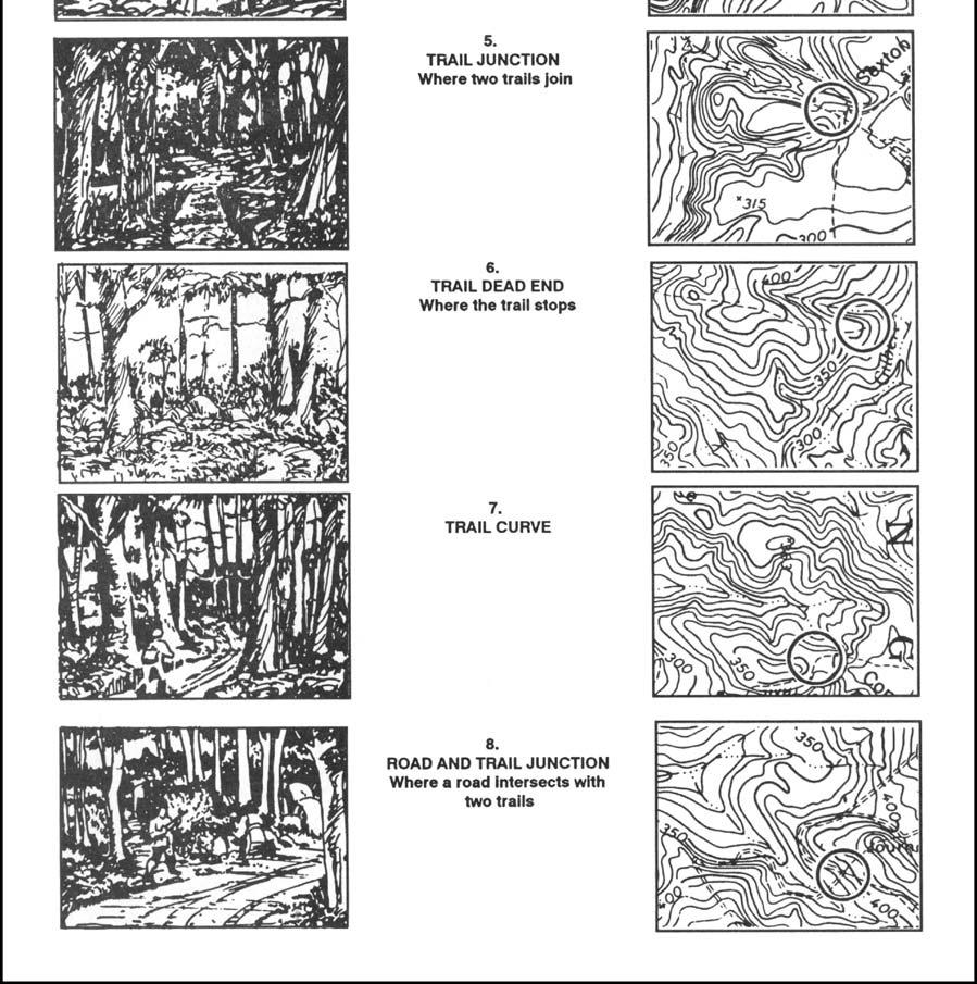
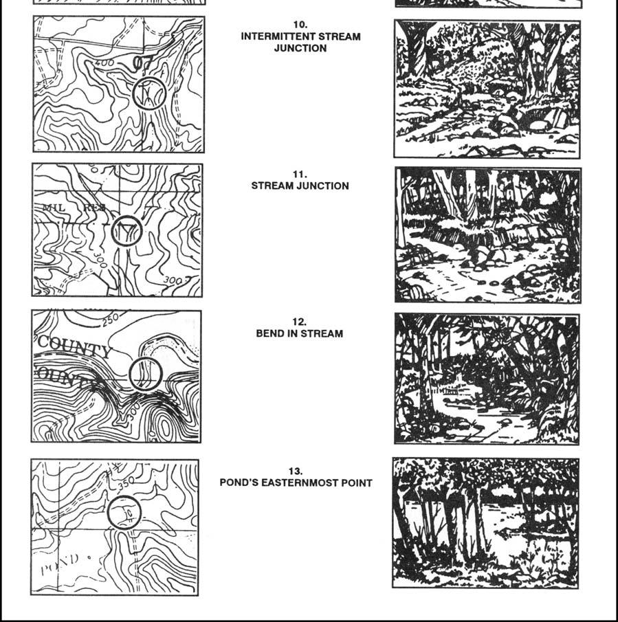
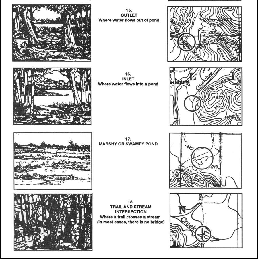
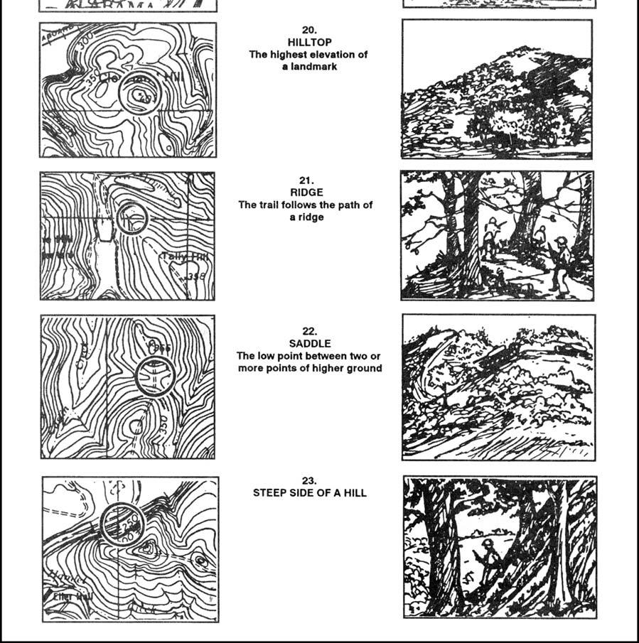
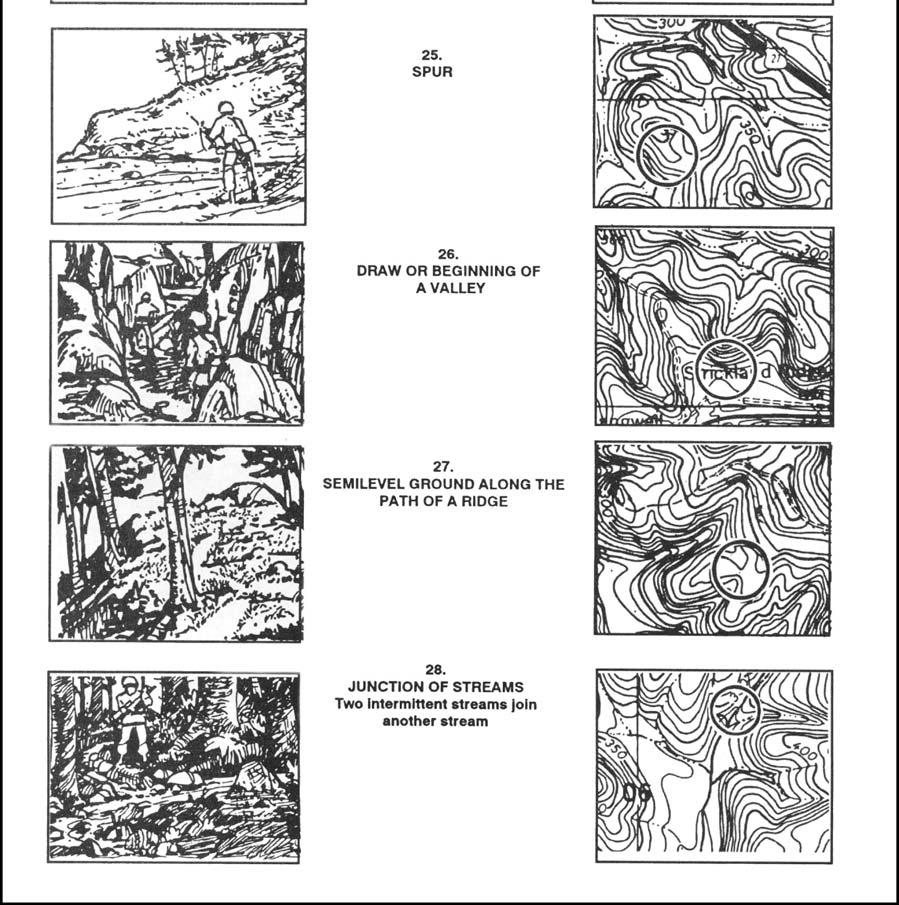
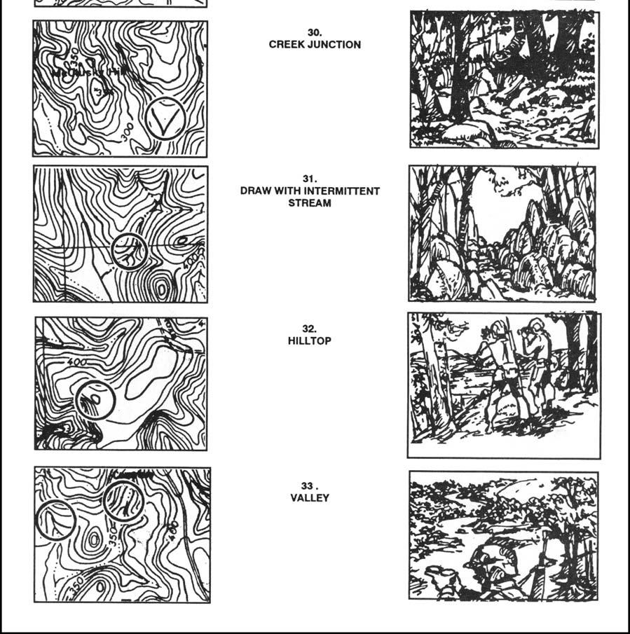
11 F-9. MAP SYMBOLS The map symbols in Figure F-9 are typical topographic and cultural symbols that can be selected for orienteering control points. The map cutouts have been selected from DMA maps. Figure F-9. Map symbols. F-11

12 Figure F-9. Map symbols (continued). F-12

13 Figure F-9. Map symbols (continued). F-13

14 Figure F-9. Map symbols (continued). F-14

15 Figure F-9. Map symbols (continued). F-15

16 Figure F-9. Map symbols (continued). F-16

17 Figure F-9. Map symbols (continued). F-17

18 Figure F-9. Map symbols (continued). F-18

19 Figure F-9. Map symbols (continued). F-10. ORIENTEERING TECHNIQUES The orienteer should try not to use the compass to orient the map. The terrain association technique is recommended instead. The orienteer should learn the following techniques: a. Pacing. One of the basic skills that the orienteer should develop early is how to keep track of distance traveled while walking and running. This is done on a 100-meter pace course. b. Thumbing. This technique is very simple, but the map has to be folded small to use it. The orienteer finds his location on the map and places his thumb directly next to it. He moves from point to point on the ground without moving his thumb from his initial location. To find the new location, the only thing that he has to do is look at the map and use his thumb as a point of reference for his last location. This technique prevents the orienteer from looking all over the map for his location. F-19
. Figure F-10. Handrails. d. Attack Points.")
20 c. Handrails. This technique enables the orienteer to move rapidly on the ground by using existing linear features (such as trails, fences, roads, and streams) that are plotted along his route. They can also be used as limits or boundaries between control points (Figure F- 10). Figure F-10. Handrails. d. Attack Points. These are permanent known landmarks that are easily identified on the ground. They can be used as points of reference to find control points located in the woods. Some examples of attack points are stream junctions, bridges, and road intersections. F-11. CIVILIAN ORIENTEERING Civilian orienteering is conducted under the guidelines of the United States Orienteering Federation with at least 70 clubs currently affiliated. Although civilian orienteering is a form of land navigation, the terms, symbols, and techniques are different from the military. a. An expert military map reader/land navigator is by no means ready to compete in a civilian orienteering event. However, military experience in navigating on the ground and reading maps will help individuals to become good orienteers. Several orienteering practices and complete familiarization with the map symbols and terms before participating in a real orienteering event is recommended. (1) Map. The standard orienteering map is a very detailed, 1:15,000-scale, colored topographical map. All orienteering maps contain only north-south lines that are F-20
21 magnetically drawn; this eliminates any declination conversions. Because of the absence of horizontal lines, grid coordinates cannot be plotted and therefore are not needed. (2) Symbols (Legend). Despite standard orienteering symbols, the legend in orienteering maps has a tendency to change from map to map. A simple way to overcome this problem is to get familiar with the legend every time that a different map is used. (3) Scale. The scale of orienteering maps is 1:15,000. This requires an immediate adjustment for the military land navigator, especially while moving from point to point. It takes a while for a person that commonly uses a 1:50,000 scale to get used to the orienteering map. (4) Contours. The normal contour interval in an orienteering map is 5 meters. This interval, combined with the scale, makes the orienteering maps so meticulously detailed that a 1-meter boulder, a 3-meter shallow ditch, or a 1-meter depression will show on the map. This may initially shock a new orienteer. (5) Terms and Description of Clues. The names of landforms are different from those commonly known to the military. For example, a valley or a draw is known as a reentrant; an intermittent stream is known as a dry ditch. These terms, with a description of clues indicating the position and location of the control points, are used instead of grid coordinates. b. The characteristics of the map, the absence of grid coordinates, the description of clues, and the methods used in finding the control points are what make civilian orienteering different from military land navigation. F-21
ORIENTEERING APPENDIX F
 APPENDIX F ORIENTEERING What is orienteering? Orienteering is a competitive form of land navigation It is for all ages and degrees of fitness and skill. It provides the suspense and excitement of a treasure
ORIENTEERING LESSON 1: ORIENTEERING
 ORIENTEERING LESSON 1: ORIENTEERING PURPOSE This lesson will introduce you to orienteering, its techniques and terminology, as well as the various types of orienteering courses. In addition, many of the
Orienteering Michael Sorrentino EDU 255 Due: May 9th 2011
 Orienteering Michael Sorrentino EDU 255 Due: May 9 th 2011 Objectives Psychomotor 1. By the end of the unit, the students will be able to correctly pace themselves using the pacing technique 3 out of 4
USING THE MILITARY LENSATIC COMPASS
 USING THE MILITARY LENSATIC COMPASS WARNING This presentation is intended as a quick summary, and not a comprehensive resource. If you want to learn Land Navigation in detail, either buy a book; or get
ILLINOIS ARMY NATIONAL GUARD Sparta Training Area 715 Industrial Drive Sparta, IL 62286
 ILLINOIS ARMY NATIONAL GUARD Sparta Training Area 715 Industrial Drive Sparta, IL 62286 103 Land Navigation Course Ph. (309) 567-6810 INDEX Chapter 1 GENERAL Page Guidance for OIC/Test Administrator 2-4
Orienteering Canada. This revised document was approved by the Orienteering Canada Board in April 2017 W55+ W65+ W17-20B M17-20B M75+ W75+ W80+ M80+
 Orienteering Canada Course and category guidelines for Championship Events: North American Orienteering Championships Canadian Orienteering Championships Western Canadian Orienteering Championships Eastern
Auckland Secondary Schools Orienteering Championship 2018
 Auckland Secondary Schools Orienteering Championship 2018 Temu Rd, Woodhill Wednesday 23rd May, 2018 The Auckland Secondary Schools Individual Orienteering Championship is being hosted by Auckland Orienteering
USING THE MILITARY LENSATIC COMPASS
 USING THE MILITARY LENSATIC COMPASS WARNING This presentation is intended as a quick summary, and not a comprehensive resource. If you want to learn Land Navigation in detail, either buy a book; or get
USING THE MILITARY LENSATIC COMPASS
 USING THE MILITARY LENSATIC COMPASS WARNING This presentation is intended as a quick summary, and not a comprehensive resource. If you want to learn Land Navigation in detail, either buy a book; or get
USING THE MILITARY LENSATIC COMPASS
 USING THE MILITARY LENSATIC COMPASS WARNING This presentation is intended as a quick summary, and not a comprehensive resource. If you want to learn Land Navigation in detail, either buy a book; or get
COACHING SAFETY GUIDELINES For all leaders of orienteering activity and coaching sessions in schools, outdoor centres, clubs and squads
 COACHING SAFETY GUIDELINES For all leaders of orienteering activity and coaching sessions in schools, outdoor centres, clubs and squads This document is offered as a guide. Each organisation or individual
ILLINOIS ARMY NATIONAL GUARD Marseilles Training Area 1700 Army Road Marseilles, IL
 ILLINOIS ARMY NATIONAL GUARD Marseilles Training Area 1700 Army Road Marseilles, IL 61341-9535 106 Land Navigation Course Ph. (815)795-5701 INDEX Chapter 1 GENERAL Page Guidance for OIC/Test Administrator
Course Planning for an NGOC League event
 NGOC Training Course Revised April 2018 Course Planning for an NGOC League event Paul Taunton Controller - Grade B (Middle), Organiser - Grade D (Lowest), Experienced Planner but no formal planner qualifications
MOUNTED LAND NAVIGATION
 CHAPTER 12 MOUNTED LAND NAVIGATION A vehicle commander should be able to navigate from one point on the ground to another with or without a compass. If separated from his unit and given an azimuth and
1. NUMBERED CONTROL DESCRIPTIONS
 ORIENTEERING AT BRIGHTON WOODS There are eight numbered posts (controls) for the orienteering course at Brighton Woods. Each has a number that corresponds to the number on the Brighton Woods Orienteering
MOUNTAIN BIKE ORIENTEERING RULES
 MOUNTAIN BIKE ORIENTEERING RULES This third version of MTBO Rules for New Zealand has been developed by the Orienteering NZ MTBO Committee and revised after the Otago and Woodhill2Whaka Carnivals. These
International Specification for Ski Orienteering Maps ISSkiOM
 International Specification for Ski Orienteering Maps ISSkiOM 2014 Approved by IOF Ski Orienteering Commission, October 2014 Approved by IOF Map Commission, October 2014 Approved by IOF Council, November,
Navigating Briones: getting around an advanced orienteering course. Brown Course, October 2011.
 Navigating Briones: getting around an advanced orienteering course. Brown Course, October 2011. The trek to the start this year wasn t short and boy was it steep. But this should be treated as an opportunity
Orienteering Canada Course and class guidelines for Canada Cup and Championship Events
 Orienteering Canada Course and class guidelines for Canada Cup and Championship Events This revised document was approved by the Orienteering Canada (OC) Board in April 2017 Revision and consolidation
Winter O /WIOL Course Design Guidelines
 2015-2016 Winter O /WIOL Course Design Guidelines ARE YOU A COURSE DESIGNER? Even if this is your first time, you know the symptoms: You think of great route choices you enjoyed and legs you would have
Derwent Valley Orienteers
 Derwent Valley Orienteers Notes for Planners of Levels C and D Events Thank you for agreeing to be a planner at a forthcoming DVO event. These notes should be read alongside the relevant British Orienteering
Chapter 6 - The Compass Upon completion of this chapter, you will be able to:
 Chapter 6 - The Compass Upon completion of this chapter, you will be able to: Explain the use of the 360 degree system in defining direction. Identify the parts of a compass, i.e.: - base plate - magnetic
Adventure Racing/Navigation 101
 Adventure Racing/Navigation 101 Adventure Racing (AR) is a multi-sport, team event in which racers navigate their way from checkpoint to checkpoint using a map, compass and route strategy within a set
Land Navigation at Nevada Youth Range Camp
 Curriculum 15-03 Land Navigation at Nevada Youth Range Camp Stephen S. Foster, Pershing County Extension Educator Sherm Swanson, Riparian and Rangeland Specialist This curriculum is used at Nevada Youth
Advanced Land Navigation
 California Cadet Corps Curriculum on Map Reading Advanced Land Navigation LEADERS KNOW THE WAY 5/22/2017 Advanced Land Navigation Agenda C1. Advanced Map Reading Techniques C2. Land Navigation C3. Designing
International Rogaining Federation Rules of Rogaining
 International Rogaining Federation Rules of Rogaining Rogaining is an amateur sport to be enjoyed by social and competitive participants and event organisers. These rules have been drafted with simplicity
USING THE GPS TO WALK TRANSECTS. by Robert L. Hafey
 USING THE GPS TO WALK TRANSECTS by Robert L. Hafey This paper will provide specific instructions or suggestions on how to setup the GPS to facilitate transect walking for field surveys. Systematic field
RULES FOR MOUNTAIN BIKE ORIENTEERING
 RULES FOR MOUNTAIN BIKE ORIENTEERING Version 2012b April 2012 This second version of MTBO Rules for New Zealand has been developed by the NZOF MTBO Committee and updated twice after the 2012 Otago Carnival
Get Your Bearings.
 Get Your Bearings A compass tells you in what direction you are headed relative to magnetic north. You can combine use of a compass with pacing to find your way across country (where there may not be any
FM CHAPTER 11 TERRAIN ASSOCIATION
 CHAPTER 11 TERRAIN ASSOCIATION Failure to make use of the vast amounts of information presented by the map and available to the eye on the ground reduces the chances for success in land navigation. The
Walk - Run Activity --An S and P Wave Travel Time Simulation ( S minus P Earthquake Location Method)
") Walk - Run Activity --An S and P Wave Travel Time Simulation ( S minus P Earthquake Location Method) L. W. Braile and S. J. Braile (June, 2000) braile@purdue.edu http://web.ics.purdue.edu/~braile Walk
Walk - Run Activity --An S and P Wave Travel Time Simulation ( S minus P Earthquake Location Method) L. W. Braile and S. J. Braile (June, 2000) braile@purdue.edu http://web.ics.purdue.edu/~braile Walk
Course Planning COF Conference
 Course Planning 2011 COF Conference Today s presentation What is a good course? Course planner s raw ingredients Cooking up good courses: Long / Middle What s different about Sprint? JWOC 2011 courses
FIRST AID (Seven Life-Savings Steps)
") FIRST AID (Seven Life-Savings Steps) Ensure area is safe before approaching victim. 1. Check for responsiveness. a. Ask in a loud, but calm voice, "Are you okay?" b. Gently shake or tap the victim on the
FIRST AID (Seven Life-Savings Steps) Ensure area is safe before approaching victim. 1. Check for responsiveness. a. Ask in a loud, but calm voice, "Are you okay?" b. Gently shake or tap the victim on the
ANSWER SHEET PART 4 EXPERT LAND NAVIGATION
 ANSWER SHEET PART 4 EXPERT LAND NAVIGATION 1. Knowing these four basic skills, it is impossible to be totally lost; what are they? a. Track Present Location / Determine Distance / Sense of Direction /
Chartwork Learn the basics for position fixing using a number of techniques and a simple equation for speed, distance and time.
 Chartwork Learn the basics for position fixing using a number of techniques and a simple equation for speed, distance and time. Chartwork Chartwork Tools Accurate chart work is the basis for good navigation.
USING THE MILITARY LENSATIC COMPASS
 USING THE MILITARY LENSATIC COMPASS WARNING This presentation is intended as a quick summary, and not a comprehensive resource. If you want to learn Land Navigation in detail, either buy a book; or get
Your First Event. All you need to know to take part
 Your First Event All you need to know to take part Orienteering is a sport combining navigation and exercise. You find a series of controls marked by an orange and white flag, using a map and, for more
New Zealand Rules of Rogaining
 New Zealand Rules of Rogaining Endorsed by the New Zealand Rogaining Association and the New Zealand Orienteering Federation Rogaining is an amateur sport to be enjoyed by social and competitive participants
Homework 2 Bathymetric Charts [based on the Chauffe & Jefferies (2007)]
![Homework 2 Bathymetric Charts [based on the Chauffe & Jefferies (2007)]](/thumbs/75/72427079.jpg "Homework 2 Bathymetric Charts [based on the Chauffe & Jefferies (2007)]") 1 MAR 110 HW-2 - Bathy Charts Homework 2 Bathymetric Charts [based on the Chauffe & Jefferies (2007)] 2-1. BATHYMETRIC CHARTS Bathymetric charts are maps of a region of the ocean used primarily for navigation
1 MAR 110 HW-2 - Bathy Charts Homework 2 Bathymetric Charts [based on the Chauffe & Jefferies (2007)] 2-1. BATHYMETRIC CHARTS Bathymetric charts are maps of a region of the ocean used primarily for navigation
CANADIAN PONY CLUB WESTERN ONTARIO REGION REGIONAL TREC OBSTACLES
 CANADIAN PONY CLUB WESTERN ONTARIO REGION REGIONAL TREC OBSTACLES August 2014 PHASE C OBSTACLE COURSE DATA SHEETS The obstacles included in this document have been used at previous WOR Regional Trec Competitions
PLACEMENT OF SIGNS RECOMMENDED PRACTICES SUB-SECTION
 Page 1 of 6 RECOMMENDED PRACTICES PART SECTION SUB-SECTION HIGHWAY SIGNS GENERAL General Proper positioning of signs is an important element in the overall control of traffic within a roadway network.
Wade Reynolds 1 Frank Young 1,2 Peter Gibbings 1,2. University of Southern Queensland Toowoomba 4350 AUSTRALIA
 A Comparison of Methods for Mapping Golf Greens Wade Reynolds 1 Frank Young 1,2 Peter Gibbings 1,2 1 Faculty of Engineering and Surveying 2 Australian Centre for Sustainable Catchments University of Southern
Lowland Leader Award. Lowland Leader Award
 Lowland Leader Award 1 Contents Introduction 4 Scope of the Lowland Leader Award Scheme 4 Stages in the Lowland Leader Award Scheme 5 Exemption from training or consolidation 8 Equal Opportunities 8 Complaints
Cross Country Skiing Rules & Regulations. Maine
 1. GOVERNING RULES The Official Special Olympics Sports Rules for Cross-Country Skiing shall govern all Special Olympics competitions. As an international sports program, Special Olympics has created these
SNOWSHOEING SPORT RULES. Snowshoeing Sport Rules. VERSION: June 2016 Special Olympics, Inc., 2016 All rights reserved
 Snowshoeing Sport Rules 1 TABLE OF CONTENTS 1. GOVERNING RULES... 3 2. OFFICIAL EVENTS... 3 25 Meter Race... 3 50 Meter Race... 3 100 Meter Race... 3 200 Meter Race... 3 400 Meter Race... 3 800 Meter Race...
The activity is designed to take about an hour start to finish.
 Troop 606 Orienteering Course Overview This Orienteering Course is designed to help Scouts satisfy requirements 4a and 4b for the First Class Rank. These requirements are as follows (as of 2017): 4a. Using
Rules for. Polyathlon. Version Released
 Object of the game: What is a polyathlon? Rules for Polyathlon Version 151021 Released Polyathlon is a series of contests or events similar to the athletic decathlon where robots compete to determine the
LENSATIC COMPASS W140009XQ STUDENT HANDOUT
 B170249XQ UNITED STATES MARINE CORPS THE BASIC SCHOOL MARINE CORPS TRAINING COMMAND CAMP BARRETT, VIRGINIA 22134-5019 LENSATIC COMPASS W140009XQ STUDENT HANDOUT Warrant Officer Basic Course Introduction
USING THE MILITARY LENSATIC COMPASS
 USING THE MILITARY LENSATIC COMPASS WARNING This presentation is intended as a quick summary, and not a comprehensive resource. If you want to learn Land Navigation in detail, either buy a book; or get
2017 Hillcrest Country Club
 2017 Hillcrest Country Club Local Rules and Conditions of Competition FOR 2017 USGA CHAMPIONSHIPS The Rules of Golf as approved by the United States Golf Association and The R&A govern play. See applicable
CROSS COUNTRY SKIING SPORT RULES. Cross Country Skiing Sport Rules. VERSION: June 2016 Special Olympics, Inc., 2016, 2018 All rights reserved
 Cross Country Skiing Sport Rules 1 TABLE OF CONTENTS 1. GOVERNING RULES... 3 2. OFFICIAL EVENTS... 3 3. FACILITIES... 3 Trails... 3 Warming Facilities... 4 Ski Area... 4 4. COURSE AND VENUE SPECIFICATIONS...
SNOWSHOEING SNOWSHOEING
 1 The Official Special Olympics Rules shall govern all Special Olympics Snowshoeing competitions. Special Olympics, Inc. is the International Governing Body for Snowshoeing. Refer to Article1, http://resources.specialolympics.org/article1.aspx,for
APPENDIX A: COURSE PLANNING PRINCIPLES
 APPENDIX A: COURSE PLANNING PRINCIPLES (Replaced Guideline 2 Principles of Course Planning in the 2002 version of the Rules in December 2010) AA1. INTRODUCTION AA1.1 The purpose of course planning principles
Appendix B: Course planning. Table of contents
 Table of contents 1. Introduction... 5 1.1 Purpose... 5 1.2 Support... 5 2. General... 5 2.1 Formats... 5 2.2 Technical Difficulty... 6 2.3 Definitions of terms:... 7 2.4 Physical difficulty... 11 2.5
OSSA MINIMUM SEARCH & RESCUE CERTIFICATION / QUALIFICATION CRITERIA BASIC LEVEL
 OSSA MINIMUM SEARCH & RESCUE CERTIFICATION / QUALIFICATION CRITERIA BASIC LEVEL Chapter 1 LEGAL ISSUES Through written evaluation the applicant will demonstrate knowledge of the legal issues involved in
CROSS-COUNTRY SKIING CROSS-COUNTRY SKIING
 1 The Official Special Olympics Sports Rules for Cross-Country Skiing shall govern all Special Olympics competitions. As an international sports program, Special Olympics has created these rules based
Rules for Orienteering USA Sanctioned Events February, 2016
 Rules for Orienteering USA Sanctioned Events February, 2016 Table of Contents A Rules for Foot Orienteering Events...5 A.1 Application and Enforcement of the Rules...5 A.2 Definitions...5 A.3 Classification
Standard Agility Event
 Dogs On Course in North America, LLC Competitive Events Course Design Philosophy Dogs On Course in North America, LLC respects that today s agility enthusiasts are talented handlers that often train for
TEST EXAM PART 3 ADVANCE LAND NAVIGATION
 NAME DATE TEST EXAM PART 3 ADVANCE LAND NAVIGATION 1. Knowing these four basic skills, it is impossible to be totally lost; what are they? a. Track Present Location / Determine Distance / Sense of Direction
In order to have a fair and consistent National League, the following guidelines must be followed.
 MBO National League In order to have a fair and consistent National League, the following guidelines must be followed. Points System for League For the purposes of the league, competitors will only be
The Rogaine Setting & Vetting Process
 The Rogaine Setting & Vetting Process by Nick Lethbridge August 2014 volume 2 :... Appendices Appendices : A1 A2 A3 A4 A5 A6 Levels of Rogaine Event A Standard Rogaine Event Levels Overview of Setter and
2017 The Country Club of Lincoln
 2017 The Country Club of Lincoln Local Rules and Conditions of Competition FOR 2017 USGA CHAMPIONSHIPS The Rules of Golf as approved by the United States Golf Association and The R&A govern play. See applicable
RULES FOR LARGEST PARADE OF VEHICLES. 6. Minimum distance of parade 3.2km (from starting line to finish line)
") 1. Written proof of official closure of road 2. Route to be marked 3. Drivers to have FULL drivers licence RULES FOR LARGEST PARADE OF VEHICLES 4. License plate numbers of all vehicles participation 5.
1. Written proof of official closure of road 2. Route to be marked 3. Drivers to have FULL drivers licence RULES FOR LARGEST PARADE OF VEHICLES 4. License plate numbers of all vehicles participation 5.
Direction-of-travel arrow. Line up the magnetic arrow and orienting arrow. bearing.
 Orienteering Direction-of-travel arrow Line up the magnetic arrow and orienting arrow. Read bearing. How to Use This Pamphlet The secret to successfully earning a merit badge is for you to use both the
Rules for Orienteering USA Sanctioned Events March, 2018
 Rules for Orienteering USA Sanctioned Events March, 2018 Table of Contents A Rules for Foot Orienteering Events... 5 A.1 Application and Enforcement of the Rules... 5 A.2 Definitions... 5 A.3 Classification
Navigation Using Compass
 Navigation Using Compass Updated January 2015 Albi Sole 0 Outdoor Council of Canada / Conseil canadien de plein air Published by The Outdoor Council of Canada / Conseil canadien de plein air KNA-101, 2500
ORIENTEERING Page 1
 ORIENTEERING 2019 - Page 1 GUIDING BODIES World Police and Fire Games Federation (WPFGF) 8304 Clairemont Mesa Blvd., #107, San Diego, CA 92111 USA TELE: (858) 571-9919 FAX (858) 571-1641 E-MAIL: worldgamesinfo@cpaf.org
Local Rules and Conditions of Competition FOR 2018 USGA CHAMPIONSHIPS
 2018 ArborLinks Local Rules and Conditions of Competition FOR 2018 USGA CHAMPIONSHIPS The Rules of Golf as approved by the United States Golf Association and The R&A govern play. See applicable championship
Homework 2a Bathymetric Charts [based on the Chauffe & Jefferies (2007)]
![Homework 2a Bathymetric Charts [based on the Chauffe & Jefferies (2007)]](/thumbs/73/69074241.jpg "Homework 2a Bathymetric Charts [based on the Chauffe & Jefferies (2007)]") 14 August 2008 MAR 110 HW-2a: ex1bathymetric Charts 1 2-1. BATHYMETRIC CHARTS Homework 2a Bathymetric Charts [based on the Chauffe & Jefferies (2007)] Nautical charts are maps of a region of the ocean
14 August 2008 MAR 110 HW-2a: ex1bathymetric Charts 1 2-1. BATHYMETRIC CHARTS Homework 2a Bathymetric Charts [based on the Chauffe & Jefferies (2007)] Nautical charts are maps of a region of the ocean
Terrestrial Trip Plan
 Terrestrial Trip Plan Provide name of all parties conducting off campus Terrestrial field work (If a UP Course, please print and attach the full class list) 1. Name: 2. Name: 3. Name: 4. Name: Departure
RANCH TRAIL JUDGING & RULES
 RANCH TRAIL JUDGING & RULES This Class contains a course on 5-acres of ranch pasture with 20 obstacles and is designed to show a horse's ability and willingness to perform several tasks that might be asked
MOTOCROSS CIRCUIT SAFETY GUIDELINES
 MOTOCROSS CIRCUIT SAFETY GUIDELINES Issue #3 OCTOBER 2012 1. The MCFederation Motocross Circuit Guidelines will be used to conduct course inspections prior to the issue of a Course Certificate and are
Appendix F: Wayfinding Protocol and Best Practices
 Appendix F: Wayfinding Protocol and Best Practices Table of Contents Introduction... 259 Current Practice... 259 Policy and Regulatory Framework... 260 Best Practices... 262 Chicago, IL... 262 Seattle,
MINIBIKE MOTOCROSS CIRCUIT SAFETY GUIDELINES
 MINIBIKE MOTOCROSS CIRCUIT SAFETY GUIDELINES Issue #4 JANUATY 2015 1. The Minibike Circuit Guidelines will be used to conduct course inspections prior to the issue of a Course Certificate 2. A Course Certificate
Table 1: Original and adjusted slope gradients for each difficulty rating Traditional Ranges Adjusted Ranges
 1 Summary Nothing beats a day spent skiing. Except, of course, a day spent designing slopes for skiing. As winter looms closer, some wealthy investors are considering purchasing Wasatch Ranch in Utah.
SECTION 5 SURF BOAT EVENTS
 SECTION 5 SURF BOAT EVENTS 5.1 GENERAL CONDITIONS Boat Crew Definition - a boat crew shall consist of five competitors, four of whom shall be rowers and the fifth shall control the boat by a sweep oar
Activity #1: The Dynamic Beach
 Activity #1: The Dynamic Beach Beach Profiling By Betsy Sheffield, COASTeam Program, College of Charleston, Charleston, SC Subjects: Science, Math Skills: Analysis, description, listing, research, small
On the Other Side Of the Ice
 On the Other Side Of the Ice Competition in Vladivostok Text and photos by Aleksei Kondratuk 63 X-RAY MAG : 78 : 2017 Participants (above and previous page) in the World Open Diving Championship in Under-Ice
Australian Barrel Horse Association Inc.
 Australian Barrel Horse Association Inc. ABHA Official Rule Book 1996 Revised Edition April 2016 ABHA RULE BOOK Page 1 Subheadings INDEX Forward 3 Logo 3 Social Media Code of Conduct 4 Bullying and Harassment
Surveying Fundamentals and Practices, 5/e
 Online Instructor s Manual to accompany Surveying Fundamentals and Practices, 5/e Jerry Nathanson Michael T. Lanzafama Philip Kissam Upper Saddle River, New Jersey Columbus, Ohio Copyright 2010 by Pearson
2009 Manual on Uniform Traffic Control Devices
 2009 Manual on Uniform Traffic Control Devices Tori Brinkly, PE Highway Safety Engineer WFL-FHWA April 20, 2010 Paragraphs are numbered. Standard Statements are bolded. Guidance statements are italicized.
National Search Dog Alliance (NSDA) Area Search Field Test with Live Subject & Cadaver
 Area Search Field Test with Live Subject & Cadaver") 1. STATEMENT OF PURPOSE This test has been promulgated by NSDA to assess the handler/k- 9 team s ability as to operational suitability for typical large area search incidents for a live subject with the
1. STATEMENT OF PURPOSE This test has been promulgated by NSDA to assess the handler/k- 9 team s ability as to operational suitability for typical large area search incidents for a live subject with the
Land Survey. 1. Pick the two points (A and B) that you would like to measure. You must be able to see clearly between the two points.
 that you would like to measure. You must be able to see clearly between the two points.") Land Survey William Clark did most of the surveying and mapping for the Lewis and Clark Expedition. When he needed to measure the distance between two points that were far apart, he used a method called
Land Survey William Clark did most of the surveying and mapping for the Lewis and Clark Expedition. When he needed to measure the distance between two points that were far apart, he used a method called
SCOTTISH HILL RUNNERS SAFETY GUIDELINES FOR COMPETITORS IN HILL RACES
 1. INTRODUCTION SCOTTISH HILL RUNNERS SAFETY GUIDELINES FOR COMPETITORS IN HILL RACES If you intend to compete in a race conducted under SHR insurance, you must comply with the SHR Generic Safety Rules
Team Leaders Meeting Day 5 Long Distance 11/06/2015
 Team Leaders Meeting Day 5 Long Distance 11/06/2015 2 Day 5 - Friday 12 th June (Monfortinho and Termas de Monfortinho) Long Distance Race 08:30-21:00: Opening hours of the EO at the EC 08:30: Last possibility
CHAPTER FIFTEEN Mini Motocross & Junior Motocross (Off Road)
") CHAPTER FIFTEEN Mini Motocross & Junior Motocross (Off Road) 15.1 MINI MOTOCROSS Introduction: Mini riding is intended to be an introduction to off road motorcycling sport, providing an outlet for youthful
CHAPTER FIFTEEN Mini Motocross & Junior Motocross (Off Road) 15.1 MINI MOTOCROSS Introduction: Mini riding is intended to be an introduction to off road motorcycling sport, providing an outlet for youthful
And Sponsored By: Nova Scotia Health Promotion
 Administered by: Nova Scotia Outdoor Leadership Development Program P.O. Box 864, Halifax, Nova Scotia B3J 2V2 And Sponsored By: Nova Scotia Health Promotion 2 Table of Contents Introduction 4 The Topographic
MINIMUM SEARCH & RESCUE CERTIFICATION CRITERIA BASIC LEVEL
 MINIMUM SEARCH & RESCUE CERTIFICATION CRITERIA BASIC LEVEL Oregon State Sheriffs Association & Oregon Emergency Management 2005 First printed May 1975 Revised and reprinted August 1980 March 1984 March
METHODS EMPLOYED IN LOCATING SOUNDINGS
 METHODS EMPLOYED IN LOCATING SOUNDINGS The soundings are located with reference to the shore traverse by observations made (i) entirely from the boat, (ii) entirely from the shore or (iii) from both. The
Interland 2018 Bulletin 4
 Interland 2018 Bulletin 4 To our O-friends, This is the final bulletin with all details necessary for Interland 2018. The organising team Course details MD + LD: Course: Classes: stage 2 MD: stage 4 LD:
USING THE MILITARY LENSATIC COMPASS
 USING THE MILITARY LENSATIC COMPASS WARNING This presentation is intended as a quick summary, and not a comprehensive resource. If you want to learn Land Navigation in detail, either buy a book; or get
Chart Features Maritime maps and Admiralty charts have these features:
 Introduction to Charts A chart or map of the area is an important safety item to carry on board. It allows the Master to obtain knowledge of the area to be travelled, and indicates the navigable channels
PART 1 BASIC LAND NAVIGATION
 PART 1 BASIC LAND NAVIGATION USING THE MILITARY LENSATIC COMPASS WARNING This presentation is intended as a quick summary, and not a comprehensive resource. If you want to learn Land Navigation in detail,
one foot. being called.
 HIGH JUMP ******************************************** RULE 7 -- JUMPING EVENTS ******************************************** SECTION 1 DEFINITIONS ART. 1...A trial is an attempt in a jumping event. Each
HERO Route Information Formats
 Page 1 HERO Route Information Formats These pages give a brief overview of the principles of how the route information will be presented on the more difficult HERO events. This covers the Base Roadbook,
FINAL DETAILS - RACE 2 GOYT VALLEY
 FINAL DETAILS - RACE 2 GOYT VALLEY Thank you for entering the second event in the 2018 series, where we ve gone back to the usual format of the 3 hour event. We are pleased to see you at this first Peak
Five Categories will be used during the regional and state competitions and is suggested as a starting point as follows:
 RA Racers Rules Preface These guidelines are intended as a starting point for churches/associations which are beginning this activity. Generally, there are four levels of RA Racer competition open to churches
SEC. 1.0 GENERAL RULES...3 SEC. 2.0 RATING EVENTS...3
 GYMKHANA COURSES SEC. 1.0 GENERAL RULES...3 SEC. 2.0 RATING EVENTS...3 2.1 Big T...3 2.2 Birangle...4 2.3 Cloverleaf Barrels (table 1)...4 2.4 Skill Barrels...5 SEC. 3.0 NON RATING EVENTS...5 3.1 Cloverleaf
2018 Beatrice Country Club
 2018 Beatrice Country Club Local Rules and Conditions of Competition FOR 2018 USGA CHAMPIONSHIPS The Rules of Golf as approved by the United States Golf Association and The R&A govern play. See applicable
GYMKHANA COURSES GC 1
 GYMKHANA COURSES SEC. 1.0 GENERAL RULES... 3 SEC. 2.0 RATING EVENTS... 3 2.1 Big T... 3 2.2 Birangle... 4 2.3 Cloverleaf Barrels (table 1)... 4 2.4 Skill Barrels... 5 SEC. 3.0 NON RATING EVENTS... 5 3.1